Showing 31 items matching "ararat map"
-
 Stawell Historical Society Inc
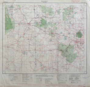
Map, Topographic Map Ararat North
... Topographic Map Ararat North...Stawell Historical Society Inc 46 Longfield St Stawell grampians Mapping Ararat North 7423-2-N Topographic Map 1:25000 Coloured 1990 Topographic Map Ararat North Map ...Topographic Map 1:25000 Coloured 1990Ararat North 7423-2-Nmapping -
Stawell Historical Society Inc
Map, Victorian Topographic Map Ararat
... Victorian Topographic Map Ararat...Stawell Historical Society Inc 46 Longfield St Stawell grampians Mapping Ararat 7423 Topographic Map 1:100000 Coloured 1966 Victorian Topographic Map Ararat Map ...Topographic Map 1:100000 Coloured 1966Ararat 7423mapping -
Federation University Historical Collection
Magazine, Ararat: The Guide, 2000-2001
... ...ararat map...Ararat community directory gwenda allgood paul hooper pat mcaloon steve shannon peter O'Rorke ted millear geoff king bill braithwaite ian couper ian manley annette newton lesley harvie j ward david hawker dianne hadden bruce chamberaine joe helper john mcQuilten denis Napthine roger hallam ararat advertiser ararat community college ararat map grampians soaring club ararat gaol ararat town hall Gum San Museum chinese Yellow and blue soft covered Ararat Community Directory Ararat: The Guide, 2000-2001 Magazine Magazine ...Yellow and blue soft covered Ararat Community Directoryararat, community directory, gwenda allgood, paul hooper, pat mcaloon, steve shannon, peter o'rorke, ted millear, geoff king, bill braithwaite, ian couper, ian manley, annette newton, lesley harvie, j ward, david hawker, dianne hadden, bruce chamberaine, joe helper, john mcquilten, denis napthine, roger hallam, ararat advertiser, ararat community college, ararat map, grampians soaring club, ararat gaol, ararat town hall, gum san museum, chinese -
 Beechworth Honey Archive
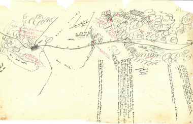
Hand-Drawn Map Centred on Ararat by Frank Lebbell Frost December 1916
... Hand-Drawn Map Centred on Ararat by Frank Lebbell Frost December 1916...Map...Ararat...Front Side: Hand-drawn map centred on Ararat, central Victoria. Details road and railway and vegetation with comments on flowering. ...Hand Drawn Hand-Drawn Map Ararat Frost Beekeeper Beechworth Honey Front Side: Hand-drawn map centred on Ararat, central Victoria. ...This is one of the maps drawn by Frank L. Frost while he was beekeeping in North-East Victoria. This particular map may be reference in the "Wooden" Diary on page 11. Front Side: Hand-drawn map centred on Ararat, central Victoria. Details road and railway and vegetation with comments on flowering. Back Side: Comments in grey lead [ca 1923]hand drawn, hand-drawn, map, ararat, frost, beekeeper, beechworth honey -
University of Melbourne, Burnley Campus Archives
Map - Topographic Survey, Ararat, 1970
... Australia 1:100,000 Topographic Survey map of Ararat district, Victoria dated 1970. Sheet 7423 (Edition 1) Series R 652. ...Produced by the Royal Australian Survey Corps. Ararat Map Topographic Survey ...Australia 1:100,000 Topographic Survey map of Ararat district, Victoria dated 1970. Sheet 7423 (Edition 1) Series R 652. Produced by the Royal Australian Survey Corps.royal australian survey corps, ararat area, stawell area -
Federation University Historical Collection
Document, Zelda Martin, Central Victorian Goldmining towns - Boom Towns or Ghost Towns?, c1996
... Black display book titled Local Towns 1 : Alma: *Brief history *Directory *Maps Amphitheatre / Mountain Hut: *Brief History Post Office Directory Ararat: *Brief History *Post Office Directory 1869 - Alphabetical Listing by Occupation *Ararat - Prominent Citizens of 1858 *Langi-Morgala Museum Avoca: *Brief History *Excerpts from 'Avoca The Early Years', Margery and Betty Beavis; pg1 - Beginnings; pg11 - The Midas Touch; pg25 - Local Gold Escorts; pg27 - A Town is Born; pg51- The Administration of Justice; pg53 - The Ways of the Law; pg61 - News of the Day; pg65 - A Time to Play; pg72 - Land Ownership *Post Office Directory (Bailliere's) 1869 *Tourism Map and Information of area *Historic Avoca - A 5.5km Tour *Avoca & the Pyrenees Region - information pamphlet Ballarat: *Early History of Ballarat - Ballarat Historical Society, Publication No.1: origin of the name; Ballaarat - the Beginning; Fabulous Yields from the Ballaarat Goldfield; *Streetscape Lydiard Street. ...Black display book titled Local Towns 1 : Alma: *Brief history *Directory *Maps Amphitheatre / Mountain Hut: *Brief History Post Office Directory Ararat: *Brief History *Post Office Directory 1869 - Alphabetical Listing by Occupation *Ararat - Prominent Citizens of 1858 *Langi-Morgala Museum Avoca: *Brief History *Excerpts from 'Avoca The Early Years', Margery and Betty Beavis; pg1 - Beginnings; pg11 - The Midas Touch; pg25 - Local Gold Escorts; pg27 - A Town is Born; pg51- The Administration of Justice; pg53 - The Ways of the Law; pg61 - News of the Day; pg65 - A Time to Play; pg72 - Land Ownership *Post Office Directory (Bailliere's) 1869 *Tourism Map and Information of area *Historic Avoca - A 5.5km Tour *Avoca & the Pyrenees Region - information pamphlet Ballarat: *Early History of Ballarat - Ballarat Historical Society, Publication No.1: origin of the name; Ballaarat - the Beginning; Fabulous Yields from the Ballaarat Goldfield; *Streetscape Lydiard Street. ...Zelda Martin was a PhD candidate at the University of Melbourne.[.1] 4th item in light blue display book titled Research Approach/Overview of Chapters/Confirmation of Canditure/Chapters1,2,3&4 of proposed thesis. *Twenty-seven page article on Victorian goldfields towns titled: Central Victorian Goldmining Towns - Boom Towns or Ghost Towns. The article was written during the author's PhD study. It outlines the context methodology, and resources and the chapters of the proposed thesis: (1) Central Victorian Goldmining Towns - The Context (2) Contemporary Views of the Factors Necessary for Town Growth (3) Outward Manifestations of Town Growth (4) The Trappings of Government (5-9) The Main Towns and Their Hinterland. [.2] 5th item in Light Blue display book as above item. *Chapter 1 of proposed thesis titled 'Pick, Shovel and Tin Dish Mining.' Covers in Section A: Central Victoria - Pre 1851: Aborigines in Central Victoria, Squatters, and Government. Section B: The years 1851-1854: The Early Gold Rushes, Government Reaction, Township Surveys, Legislation, Town Development, Local Government and Early Settlement. [.3] 6th item in Light Blue display book as above item. *2A of proposed thesis titled 'Contemporary Views of the Factors Necessary for Town Growth'. Similar information to Chapter 1 plus extra re towns and maps. Sections: Introduction, Context of Place - Geographical Towns Listed, The Context of Time - Pre1851 Aborigines, Governance of Port Phillip, The Squatters, The Villages of Central Victorian Highlands, Conclusion, Condensed Version of Chapter2B. [.4] 7th item in Light Blue display book as above item. *Chapter2B of proposed thesis. Sections: Area of Research, Schools, Banks, Newspapers, Progress Association, Town Development - Sandhurst (Bendigo), Ballarat, Castlemaine,, Maryborough, Ararat and Stawell. [.5] 8th item in Light Blue display book as above item. *Chapter 3 of proposed thesis titled 'Outward Manifestations of Town Growth'. Sections: Introduction, Contemporary Writing, Educationalists, The Bankers, The Townsfolk, Current Theory, General Theories of Urban Development, and Conclusion. [.6] 9th item in Light Blue display book as above item. *Chapter 4 of proposed thesis titled 'Trappings of Government' Sections: Introduction, Early Government Attitudes to Mining and Town Development, Law and Order, Township Surveys, Legislation, Local Government, Transport and Communication, The People and Lobbyists. [.7] 10th item in Light Blue display book as above item. *'The Rise and Fall of Central Victorian Goldmining Towns'. Includes a map showing main Goldfields, a table showing towns and villages at two points in time - 1857 and 1871; a Bibliography of Primary and Secondary Sources. [.8] Resource No1. Black display book titled Local Towns 1 : Alma: *Brief history *Directory *Maps Amphitheatre / Mountain Hut: *Brief History Post Office Directory Ararat: *Brief History *Post Office Directory 1869 - Alphabetical Listing by Occupation *Ararat - Prominent Citizens of 1858 *Langi-Morgala Museum Avoca: *Brief History *Excerpts from 'Avoca The Early Years', Margery and Betty Beavis; pg1 - Beginnings; pg11 - The Midas Touch; pg25 - Local Gold Escorts; pg27 - A Town is Born; pg51- The Administration of Justice; pg53 - The Ways of the Law; pg61 - News of the Day; pg65 - A Time to Play; pg72 - Land Ownership *Post Office Directory (Bailliere's) 1869 *Tourism Map and Information of area *Historic Avoca - A 5.5km Tour *Avoca & the Pyrenees Region - information pamphlet Ballarat: *Early History of Ballarat - Ballarat Historical Society, Publication No.1: origin of the name; Ballaarat - the Beginning; Fabulous Yields from the Ballaarat Goldfield; *Streetscape Lydiard Street. *Hand drawn map showing Leigh River, Old Portland Bay Road, plaque on road to Colac; etc. *Newspaper article re 'The Theatre Royal' ( which stood in the vicinity of the current Owen Williams store) - 'The News'15/04/1998 *Article - 'Ballarat's Mechanics' Institute Lives On' Ballarat Courier, 14/09/1985 *Article - Standing the Test of Time' The News 17/11/1993 re The Mechanics Institute & picture of the Reading Room *'Ballarat a Study of a City, Phyllis Reichl, pub. Nelson, 1968; no.3 place, time and people field studies series *Investigator Vol.33 No.2, 1998 Geelong Historical Society. Article on pg75 describes Ballarat in 1861 *Folded poster - 'Ballarat 100' a history of telegraph communication, pub. Telecom. Beaufort (Fiery Creek): *Brief history *Post Office Directory [.9] Resource No.2 Black Folder Titled Towns cont.No2 Bendigo (Sandhurst): *'Family & Local History at the Bendigo Library - 1851-2001 150 years of gold'. *Bendigo Government Camp in 1853 illustration; key to sketch and names of Government officers stationed there *Excerpts from 'Bendigo and Vicinity' Adolph Haman *The Bendigo Goldfield Registry - pgs 1-7 Introduction *Excerpt: 'Breaking the Grip' *Excerpt: The Most Go-Ahead Place *Excerpts from 'History of Bendigo' - anti license agitation; laying out of town; proposed railway; gold calls and dividends; the Sandhurst Municipality; journalism *Bibliography Blackwood: *Excerpts from 'Aspects of Early Blackwood - The Goldfield, the Landmarks, the Pioneers' Alan J Buckingham and Margaret F Hitchcock, JG Publishing,1980 Buninyong: *A Brief History *Investigator Vol1 No.2 Feb 1966 Geelong Historical Society. Pg3 - Article re gold escort route - Mt Alexander to Adelaide - (see a simple monument on the Western Highway a few miles out of Horsham. Pg 15 - Ballarat Excursion - re the finding of gold. *Three articles published by Buninyong and District Historical Society Inc: (Magpie Exploration; Finding Gold In The Green Hills; Magpie Exploration; Burnt Bridge to Cargarie to Mt Mercer) *Copies of newspaper articles/items *Buninyong Street Directory Carisbrook: *In the Beginning There Was Carisbrook *The History of the Carisbrook Racecourse Carngham / Snake Valley: *Brief History *Directory Castlemaine: *Directory 1865-1866 - Alphabetical and Street *Poster - Castlemaine A Contemporary Guide "The Great Centre" 1866 - A Contemporary Guide to the Fascinating Past *Pamphlet - Castlemaine District Community Hospital *Map - Castlemaine, Maldon & Surrounding Districts *Map and Information - The Dry Diggings Track - a 55kl walk among historic goldfields relics ( Castlemaine Fryerstown Vaughan Mt Franklin Hepburn Daylesford) *Postcard - Former Court House *Directory 1867 - Alphabetical, Trade [.10] Resource No.3 Grey folder Titled Towns 3 Creswick to Maryborough Creswick: *Brief History *Booklet - "Creswick Cemetery Walk" *Booklet - The Buried Rivers of Gold Heritage Trail Creswick *Creswick Historical Museum Information Sheet *Chronological History of Creswick *Alphabetical Directory of the Borough of Creswick *Creswick's Creek Directory 1856 *Historic Creswick Walking Tour *A Brief Account of the Schools of Creswick - Past and Present *100 Years of Railway Travel in Creswick *The Berry Deep Leads *The Spence Home at Jackass Gully in the Creswick State Forest ( William Guthrie Spence - Pioneer) *The New Australian Mine and the 1882 Disaster *Creswick District News, Issue 7, July August 1999 *The Creswick Miners Walk - Information and Map *Maps Chewton: *Brief History *Directory Clunes: *Brief History *Clunes Street Directory Daylesford: *Brief History *Notable Bushfires in Daylesford District Over More Than a Century - "Black Thursday" 1851; 1862; 1899; the Disastrous Hepburn Fire of 1906; 1939; 1944; 1969. *Post Office Directory -Daylesford and Hepburn Dunolly / Inkerman: *Brief History *Directory *Pamphlet - Goldfields Historical Museum *Pamphlet - Historic Dunolly - Victoria's Best Kept Secret *Map of Gold Workings at Dunolly Area - showing where the main gold rushes occurred *Brief History - Inglewood *Directory - Inglewood - Name Occupation, Dwelling Kingower: *Brief History *Directory - Name / Ocupation / Dwelling Linton / Happy Valley / Piggoreet: *Brief History *Directory - Lintons McIvor: *"A History of the Shire and the Township of Heathcote" by J.O. Randell Majorca: *Brief History *Official Post Office Directory 1869 - Name / Occupation/ Address Maldon (Tarrangower): *Brief History Part 1 *Brief History Part 2 *Post Office Directory *List - Alphabetical Order by Names plus Business and Trade (Tarrangower Times Oct/1858) *List - Alphabetical Order by Trade plus Name and Business *Directory - Name / Occupation / Dwelling Maryborough: *Worsley Cottage - built by Arthur Worsley, a contractor in stonework in 1894 [.11] Resource No. 4 Blue Display Book titled Towns 4 Moliagul to Stawell Moliagul: *Brief History *Moligul Legislative Assembly (Voting?) List - Names and Occupations *Moliagul Victorian Post Office Directory 1868 - Name / Ocupation / Address / Comments *"The Welcome Stranger" gold nugget *The Sunday School *The Welcome Stranger Discovery Walk - information and map Moonambel (Mountain Creek) Redbank *Brief History *List of names extracted from advertisments of the Pioneer and Mountain Creek Advertiser 16/02/1861. *Bailliere's Directory 1869 - Alphabetical List of Name / Occupation / Place St Arnaud: *Brief History Sebastapol: *Brief History *Directory 1869 - Alphabetical by Name; plus occupation and address. Browns and Scarsdale: *Brief History *Browns Street Directory - Name and Occupation Smythesdale: *Brief Description *Smythesdale Street Directory -Name and Occupation Stawell (Pleasant Creek) *Brief History *Victorian Official Post Office Directory - Name /Occupation / Dwelling *Chronology - 1841-1920 *Production of gold statistics - 1879 - 1900 *Big Hill *Extracts from "The Golden Years of Stawell". Chapt 1 - Stawell's Coming Out. Capt. 2 - The Gold Rush. Caapt.3 - Cradle of Democracy. Chapt.4 - The Reefs Becomes Stawell. Chapt. 5 - Rushing In. Chapt.6 - The Pioneers. Chapt 7 - The Decade of Optimism. [.12] Resource No. 5: Blue Display Book titled 'Towns Steiglitz to the The Golden Triangle. Steiglitz: Brief History Victorian Post Office Directory 1869 *Map of Steiglitz *List of maps relevant to Steiglitz history *Information 6 tables of data from "Reports of Mining Surveyors Talbot (Back Creek) Brief History Taradale: Post office Directory 1869 - Name/Occupation/Street. Also list in alphabetical order by Occupation Taradale *Chronological Reference to Taradale Mines *Water - The Coliban System of Waterworks *Joseph Brady *The Syphon Tarnagulla (Sandy Creek) *Brief History *Tarnagulla Businessmen Cameos to give depth to advertisments in 'The Tarnagulla Courier' various issues 1864-1871 *Directory - Name/Occupation /Address *List - Name/Business/Trade Wedderburn (Koorong) *Brief History *List - Name/Occupation The Golden Triangle: *The Early Rushes - Wedderburn / Moliagul / Sandy Creek - Tarnagulla / Jones Creek - Waanyarra / Kingower / Dunolly - Goldsborough / Inglweood *Census of 1857 - Population / Occupations *1858-1871 - A Time of Consolidation- Wedderburn / Moliagul / Sandy Creek- Tarnagulla / Arnold *Census 1871 - Population *Information gleaned from the census data - Demographics / Population / Occupations / marital / Birthplace / Religion / Literacy/ Occupation and Housing Cameos *Graphs - Birthplace of settlers /Male-Female Ratio / Married males / Children under 15 as Percentage of Population / Religion *Census 1857 - Statistical data *Maps *Bibliography [.13] Resource No. 6 - Black Display Book Information and Research in Central Victoria including: *Banking - Research from ANZ Bank Archives *Institutions - also includes articles listed from the Ballarat Times Newspaper *Australian mining History Association - A.M.H.A. Bibliography *Australia's Mining History * Bibliography - Land Surveys Victoria - *1853 Administration (Statistics and Other) includes: schools / ministers of religion / police / military / local administration / licences for sale of spirits / distances between various Victorian gold fields. * Victoria Government Gazette (Copy) - N0. 116, 12/12/1854 includes: Gold Felds Commission of Enquiry & No. 85, 15/09/1854 - Addresses presented to the Lieutenant Governor (Sir Charles Hotham) during his tour through the Gold Fields of Victoria,1854. Addresses on behalf of : the people of Bendigo; Members of the Church of England, Bendigo; Members of the Wesleyan Church on the Bendigo Gold Fields; Bendigo Gold District General Hospital; the Bendigo Prospecting Association; Committee of the Bendigo Local Exhibition; Bendigo District Medical Association; Coloured Americans Resident at Bendigo; German Inhabitants of Bendigo; Landowners, Inhabitants, and Miners of Castlemaine; Inhabitants of Forest Creek; Inhabitants of Heathcote and Gold Miners of McIvor; Residents and landholders of the District of Bacchus Marsh; Inhabitants of Kilmore and Vicinity. *Gold Fields Correspondence 1853: letter from Lieutenant Colonel Valiant, (Officer commanding the Troops in Victoria) to the Lieutenant Governor re threatened disturbance at Sandhurst (Bendigo) regarding the Gold License Fee. * Extracts from a book "Victoria" re Gold Fields Commission of Enquiry involving mainly Ballarat and Castlemaine and a chapter titled 'A Tour to the Victorian Gold-Fields' *Lists of central Victorian newspapers - listed by date published 1851to 1874; by first date available to State Library. *A list of cities and towns showing County, population in 1861 &1871, and municipal status. [.14] Resource no.7. Black display book. *Reference: Papers presented to Parliament Victoria - 1859-1860 4 volumes - relevant sections copied. Contains information on Branches of Government. General / Finance / Gold / Gazette / Commission and Warrant / Statistic. *Gold Fields Act. In accordance with the Act the gold fields are divided into six districts - Ballaarat, Castlemaine , Sandhurst, Avoca, Ararat, and Beechworth.. Official staff in each gold district consists of a Resident Warden, Wardens, Wardens' Clerks, Bailiffs, Chinese Protectors, Chinese Interpreters, and Mining Surveyors. *Gold Receiver *Gaols *Police magistrates and Clerks of Petty Sessions, etc. *Field Branch *Immigration and Emigration Overland - Chinese - 1859 *Population on the Goldfields *The Geological Survey - The Government Geologist is assisited by staff from four branches - the office Branch; the Publishing Branch; the Field Branch and the Museum Branch. *Commission to Enquire Into Sludge dated 10/02/1859 (Some sections copied) - Report to the Honorable Chief Commissioner of Public Works, Melbourne re the mode of carrying the sludge from the puddling mills in Sandhurst without interfering with the drainage of the town and the roads in the neighbourhood. [.15] Resource No.8: Camel display book titled Resource No. 8. Aborigines *Lists of book titles - +"Readings in Victorian prehistory" +"The Aborigines of Port Phillip" +Aboriginal languages and clans" +"A History of the Port Phillip District" +"Langi Ghiran 1: Aboriginal Rock...." +"Koorie History: sources for aboriginal studies in the State Library of Victoria", ed. Tom Griffiths, Melb. Friends of the State Library, 1989 +"The Public Lands of Australia Felix"; settlement and land appraisal in Victoria1834-91 with special reference to the Western Plains", J.M.Powell, Melb. Oxford University Press 1970 +*Bibliography of the Victorian Aborigines' from the earliest manuscripts to 31st December 1970, Massoa, Aldo, Melb. Hawthorn Press, 1971 +"Aborigines in Colonial Victoria, 1836-1886", M.F. Christie, Sydney University Press, 1979 +"Urban and Industrial Australia: readings in Human Geography" ed J.M. Powell, Melb. Sorrett Pub. 1974 *Extracts: -Processes of Pioneer Settlement - The Squatting Occupation of Victoria, 1834-60. J.M. Powell -Areal Variations in the Class Structure of the Central-Place Hierarchy. P. Scott - Volume1 and Volume 2: Notes Relating to the Habits of the Natives of Other Parts of Australia and Tasmania. Compiled from various sources for the Government of Victoria by R Brough Smyth. John Curry, O'Neil, Melb. 1st pub. Melb. 1876. p31-45 - Numbers and Distribution of the Aborigines in Victoria -Victorian Aborigines 1835-1901 - A Resource Guide to the Holdings of the Public Record Office, Victoria; published by the Government Information Centre 1984. *History of the Aboriginal Artefacts Displayed in the Daylesford Museum. F. G. Powell (4 page pamphlet) *Letter to Zelda Martin from Peter Lovett, Cultural Officer, Ballarat & District Aboriginal Co- Operative, 05/02/1997 *Map: Ian Clarke Victorian Tribunal Boundary Map - Clans of Central Victoria. *Victorian Rock Art and Mythology - Article about Mount Langhi Ghiran and myths of the Tjapwarong people. *Two Aboriginal myths relating to the Grampians - 'The Monster Emu' / 'The Aquisition of Fire', by the Aborigines in the Grampians Areas *Article titled (chapter 8) Ballarat - information re camping sites in the region. Lake Wendouree / Lake Burrumbeet (includes a myth) / Mt Bunninyong / Lal Lal / Pitfield / Mount Elephant / Mount Egerton / Meredith / Lake Goldsmith / Lake Learmonth / Ercildoune *Notes on the Aborigines of the Wider Ballarat Region plus European names=Aboriginal names. John Morris 26/07/1995 *Role of Aborigines in Town Development in Central Victoria. Mentions Native Police Force est. in Port Phillip 1842 and Central Board for Aborigines est. 1860 *The Grave of King Billy. (Frank Wilson) Pamphlet. *Camping Places in Central and Northern Victoria. Article re Lake Burrumbeet site. *Programme for the Unveiling of Memorial Cairn for Edward Stone Parker 1802-1865. Note portrait not accurate. Accurate portrait is available in the book "A Successful Failure A Trilogy The Aborigines and Early Settlers", Edgar Morrison, Graffiti Publications, 2002. * Large envelope addressed to Mr G Netherway containing newspaper cuttings regarding the life of Edward Stone Parker, the unveiling of the Memorial Cairn as mentioned above, articles titled 'Episodes from Our Early Days' (Edgar Morrison, Yandoit)- The Black's School, A School At Last and The Final years. Also a typed page titled 'Historical Background to E.S.Parker's Career. Includes an interesting tale titled 'When the cat lay doggo' re laying power leads for the unveiling ceremony at the memorial site. [.16] green display folder titled 'Research Aids' *List of references to Commissioners' & W'ardens' Reports (formerly held at La Trobe Library Archives, now at Public Records Office [PRO]). Indicates town referred to / date of report / name of camp if different to town. * Archive information re Anglican Records *Movement around the Goldfields - Miners and Storekeepers - usefulness of newspapers in providing information - areas covered - Castlemaine, Maldon, Ararat, Stawell, Tarnagulla, Dunolly. *Port Phillip /Victoria Directories 1839/1867 - Chronological list of Directories included in this series. *"Notes on the History of Local Government in Victoria" A.W. Greig Melb. University Press 1925 - Photo-copied extract p5-p40. (Source - Deakin University Library) - Introduction by W.Harrison Moore. Section 1 - Development in New South Wales Before Separation. Section 2 - Development in Victoria After Its Separation from New South Wales. Hand written notations: 'roads, markets, and local government 1855 on' ;'opportunity of squatters in parliament' and 'opportunities of matters in parliament p33' * Notes on the Establishment of Surveyor General's Department 1851and Commissioner of Crown Lands and Survey. * Newspaper articles from The Argus, 1849, re the discovery of gold in the Pyrenees region. * Excerpt - a report on schools - A.B.Orlebar, Inspector; re the need for permanent school buildings rather than tents. *Excerpt from - 'Approaches to Urban History', Sean Glynn: The Case for Caution * Except from - 'The Urban Sprinkle', Weston Bate: Country Towns and Australian Regional History *Reference- 'The History of Land Tenure in the Colony of Victoria', John Quick. References the Haines Land Bill, land tenure and Land Leagues. [.17] Light blue envelope folder titled 'Birtchnell's Ballarat, etc. Directory 1862 *Contains various directories for Smythesdale, Buninyong, Clunes, Brown's and Creswick. [.18] Red envelope folder no.2 titled Victorian Gazetteer *Selected pages from 1869 Victorian Gazetteer on A4 paper (with a handwritten note questioning if some pages are from 1868 Victorian Gazetteer as appears to be different sizes - A3 pages.) Information includes locations and descriptions of towns, hotels, banks, communications and populations. (Does not include names, residences and occupations) [.19] Red Envelope folder titled Bailliere's Official Post Office Directory 1868 (or1869 or a mixture of both?) *Preface *Contains a selection of pages of towns highlighted in yellow in the the index *Work on this directory was commenced in 1867. *Information includes: Municipalities - mayors and councilors; lists of towns naming male inhabitants and their occupations. [.20]Yellow manila folder titled Post Grad Seminar Presentation 1996 *Gives some background to Zelda Martin's proposed thesis and why she chose the topic Gold Mining Towns Boom or Bust [.21] A3 display book - No. 1A * A list of 'Relevant Newspapers collected: The Tarrangower Times and Maldon Advertiser (first published 1858) Includes dates 1858-1867. The Mount Alexander Mail. Includes dates 1854-1866 The Tarnagulla Courier. Includes dates from1864-1871 Dunolly and Burnt Creek Express. Includes dates from 1862-1871 * Selection of newspaper pages from The Mount Alexander Mail 1854 to 1856, mostly showing advertisements for businesses and services provided to that community. [.22] A3 display book - No. 1B * Selection of newspaper pages from The Mount Alexander Mail 1857 to 1866, mostly showing advertisements for businesses and services provided to that community. [.23] A3 display book -No. 2 * Selection of newspaper pages from The Tarnagulla Courier 1864 to 1871, mostly showing advertisements for businesses and services provided to that community. [.24] A3 display book - No. 3 *Selection of newspaper pages from The Tarrangower Times (and Maldon and Newstead) Advertiser 1858 to1867, mostly showing advertisements for businesses and services provided to that community. [.25] A3 display book - No.4 * Selection of newspaper pages from The Dunolly and Burnt Creek Express; and The Dunolly and Betbetshire Express 1862 to 1871, mostly showing advertisements for businesses and services provided for that community. [.26] A3 display book - No.5 Includes: * Bryce Ross's Diggings Directory. Includes instructions for using this directory. This directory was used by "all persons having connexion or desiring to communicate with 'working parties, private friends, or Stores at the Diggings." As a directory for each area wwas completed it was published in each month's issue of Bonwick's "Digger's Magazine." Years c1852/1853. This Directory commences first at the head of Forest Creek. Includes a directory for Bendigo and Ballarat. Of interest at the end of the Bendigo and Ballarat directory is a list of the number of storekeepers, butchers, doctors, smiths, eating houses, lemonade sellers and chapels. * The Castlemaine Directory and Book of General Information Comprehending Glass's Model Calendar for the Two Years 1862 and1863. "zelda martin, victorian goldfield towns, bendigo, castlemaine, ballarat, maldon, stawell, ararat, maryborough, creswick, avoca, heathcote, banks, bank of australasia, union bank of australia, government camp, sandhurst, water supply, tarnagulla, talbot, back creek, mountain creek, police court, carisbrook, dunolly, thompson's foundry, charles clacy, anthony trollope, robert cecil, mount alexander, urbanisation, national schools, education, govenrment, industry, railway, transport, settlement, land settlement in central victoria, steiglitz, joseph brady, the new australian mine, berry deep leads, william guthrie spence, creswick state forest, arthur worsley, worsley cottage, the welcome stranger, moliagul, moonambel, redbank, st arnaud, sebastapol, brown's, scarsdale, clunes, chewton, daylesford, bushfires, inkerman, inglewood, kingower, lintons, happy valley, piggoreet, mcivor, majorca, tarrangower, taradale, the coliban system, the syphon, sandy creek, wedderburn, koorong, arnold, jones creek, waanyarra, the golden triangle, census 1857, blackwood, buninyong, durham lead, magpie, carngham, snake valley, alma, amherst, daisy hill, amphitheatre, mountain hut, beaufort, fiery creek, counties, population, gold fields commission of enquiry1854, william westgarth, gold license fee, lieutenant colonel valiant, administration of the victorian gold fields, commission to enquire into sludge 1859, e.s. parker, edward stone parker, edgar morrison, mount franklin protectorate, dja dja wurrung, memorial cairn, franklinford, mt franklin memorial cairn, jajowurrong, dja dja wurung, tjaowarong, wothowurong, assistant protectors, daylesford museum, buluk, rock art - grampians, aboriginal mythology - grampians, aborigines, first nations people, mount franklin, aboriginal artifacts, lake burrumbeet, native police force, central board of aborigines, yandoit, commissioners' reports, wardens' reports, port phillip/victoria directories 1839-1867, local government - victoria 1853/1854, surveyor general's department - 1850's, victorian schools 1850's, a.b.orlebar, haines land bill, william charles haines, wilson gray, land tenure, land leagues, victorian gazetteer, the tarrangower times and maldon advertiser - 1858-1867, the mount alexander mail 1854-1866, the tarnagulla courier 1864, dunolly and burnt creek express 1862-1871, bryce rose's diggings directory, the castlemaine directory 1862-1863 -
 Bendigo Historical Society Inc.
Book - CHINESE CEMETERIES IN AUSTRALIA, VOLUME 3. CHINESE GRAVES AND CEMETERIES IN VICTORIA, 2003
... Ararat, Vaughan, Pennyweight Flat. Publisher: Golden Dragon Museum, Bendigo. ISBN: 09578013 7 8. 93 pages. Black and white illustrations & map....Ararat, Vaughan, Pennyweight Flat. Publisher: Golden Dragon Museum, Bendigo. ISBN: 09578013 7 8. 93 pages. Black and white illustrations & map. ...Chinese Cemeteries in Australia, Volume 3. Chinese Graves and Cemeteries in Victoria: Echuca, Avoca, Rutherglen, Yackandandah, Eddington, Ararat, Vaughan, Pennyweight Flat. Publisher: Golden Dragon Museum, Bendigo. ISBN: 09578013 7 8. 93 pages. Black and white illustrations & map.Dr Kok Hu Jincemetery, chinese, bendigo cemeteries victoria, chinese graves, genealogy -
 Bendigo Historical Society Inc.
Document - J W SWATTON COLLECTION: RACV ROUTE MAPS
... Four RACV Route Maps and Touring Information, Bendigo to Alexandra via Seymour and Yea, Bendigo to Mt Gambier and return, Bendigo to Horsham via Ararat and Bendigo to Anglesea, dated 1 March 76. ...History House 11 Mackenzie Street Bendigo goldfields J W Swatton Collection Royal Automobile Club of Victoria Four RACV Route Maps and Touring Information, Bendigo to Alexandra via Seymour and Yea, Bendigo to Mt Gambier and return, Bendigo to Horsham via Ararat and Bendigo to Anglesea, dated 1 March 76. ...Four RACV Route Maps and Touring Information, Bendigo to Alexandra via Seymour and Yea, Bendigo to Mt Gambier and return, Bendigo to Horsham via Ararat and Bendigo to Anglesea, dated 1 March 76. Also an unsigned Safe Driving Pledge.j w swatton collection, royal automobile club of victoria -
 Bendigo Historical Society Inc.
Document - LIST OF MAPS, PLANS, REPORTS PUBLISHED BY MINES DEPARTMENT VICTORIA 1938
... Booklet contains list of publications of geological reports, maps etc for Ararat, Ballarat, Beechworth, Bendigo, Castlemaine, Gippsland, Maryborough....Booklet contains list of publications of geological reports, maps etc for Ararat, Ballarat, Beechworth, Bendigo, Castlemaine, Gippsland, Maryborough. ...Blue booklet, on front ' List of Maps, Plans, Reports and other publications of the Mines Department of Victoria. Issued by Geo Brown Secretary for Mines under the authority of The Hon. E.J. Hogan, MLA, Minister of Mines. Booklet contains list of publications of geological reports, maps etc for Ararat, Ballarat, Beechworth, Bendigo, Castlemaine, Gippsland, Maryborough.Geo Brown, Secretary for Mines under the authority of The Hon.E.J. Hogan, M.L.A. Minister of Mines.organisation, government, geological maps list -
 Federation University Historical Collection
Book, Stanley B. Hunter, Memoirs of the Geological Survey of Victoria No 7., The Deep Leads of Victoria, 1909
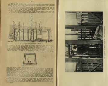
... Contents include tunnelling, deep sinking, the Chiltern Method, the Ballarat Method, Stawell, Ararat, Moyston, Raglan, Wimmera, Landsborough, Avoca, Ballarat West Leads, Berry-Moolort-Loddon Lead System, Clunes, Creswick, Bullarook Affluent, Corinella, Daylesford-Castlemaine Tributary, Majorca-Carisbrook tributary, Huntly, Coliban, Campaspe, Rutherglen., Smythesdale, Durham Lead, Tanjil, Evolution of Mining Machinery, size of claims, Definition of a Deep Lead, Discovery of Gold in Victoria, Geographical Position of Deep Leads, Water in Deep Leads, Methods of Deep Lead Mining, Cost of Deep Lead Mining, Stawell, Ararat, Moyston, Raglan, Wimmera, Landsborough, Avoca, Ballarat West, Berry, Springs Hill, Loddon Valley, Charlotte Plains, , Timor, Burn Creek, Huntly, Colinan, Goulburn, Ovens Valley, Chiltern, Indigo, Morrison's Lead, Plans include: geological Map of Stawell, ararat, Raglan and Landsborough; Kempson's Freehold Mine, Stawell; Geological Map of Beaufort, Avoca, Maryborough, Ballarat west, Berry-Moolort, Loddon, Creswick, Marong, &c; Cardigan Propriety Gold Mine; Working Miners United Gold Mine, Homebush; Hepburn Deep Lead Plan; Madame Berry West Mine; West Berry Consols Mine; Spring Hill and Central Leads; Berry Consols Extended Mine; Loddon Valley Goldfields; Chalk's No 3 Mine; Charlotte Plains Considated Mine; Duke United Mine; Geological Map of Bendigo, Huntley, Campaspe, Malmsbury, Kyneton, trentham, &c; Geological Map of Chiltern, Rutherglan, Eldorado, Beechworth, &c; Chiltern Valley Gold Mine; Wallace Chiltern Valley Consols Mine; great Southern and Chiltern Valley United Mine; great Northern extended Consols; Prentice and Southern deep Leads; Glenfine South Gold Mine; Geological map of Pitfield, Rokewood, Mt Mercer, Ballark, Meredith, &c.; McEvoy Mine; Dargo . . . . . . . . . . . . . . . . . . . . . . . ...Contents include tunnelling, deep sinking, the Chiltern Method, the Ballarat Method, Stawell, Ararat, Moyston, Raglan, Wimmera, Landsborough, Avoca, Ballarat West Leads, Berry-Moolort-Loddon Lead System, Clunes, Creswick, Bullarook Affluent, Corinella, Daylesford-Castlemaine Tributary, Majorca-Carisbrook tributary, Huntly, Coliban, Campaspe, Rutherglen., Smythesdale, Durham Lead, Tanjil, Evolution of Mining Machinery, size of claims, Definition of a Deep Lead, Discovery of Gold in Victoria, Geographical Position of Deep Leads, Water in Deep Leads, Methods of Deep Lead Mining, Cost of Deep Lead Mining, Stawell, Ararat, Moyston, Raglan, Wimmera, Landsborough, Avoca, Ballarat West, Berry, Springs Hill, Loddon Valley, Charlotte Plains, , Timor, Burn Creek, Huntly, Colinan, Goulburn, Ovens Valley, Chiltern, Indigo, Morrison's Lead, Plans include: geological Map of Stawell, ararat, Raglan and Landsborough; Kempson's Freehold Mine, Stawell; Geological Map of Beaufort, Avoca, Maryborough, Ballarat west, Berry-Moolort, Loddon, Creswick, Marong, &c; Cardigan Propriety Gold Mine; Working Miners United Gold Mine, Homebush; Hepburn Deep Lead Plan; Madame Berry West Mine; West Berry Consols Mine; Spring Hill and Central Leads; Berry Consols Extended Mine; Loddon Valley Goldfields; Chalk's No 3 Mine; Charlotte Plains Considated Mine; Duke United Mine; Geological Map of Bendigo, Huntley, Campaspe, Malmsbury, Kyneton, trentham, &c; Geological Map of Chiltern, Rutherglan, Eldorado, Beechworth, &c; Chiltern Valley Gold Mine; Wallace Chiltern Valley Consols Mine; great Southern and Chiltern Valley United Mine; great Northern extended Consols; Prentice and Southern deep Leads; Glenfine South Gold Mine; Geological map of Pitfield, Rokewood, Mt Mercer, Ballark, Meredith, &c.; McEvoy Mine; Dargo . . . . . . . . . . . . . . . . . . . . . . . ...Pink paper covered book by Stanley Hunter, Engineer in Charge of Boring Operations. Contents include tunnelling, deep sinking, the Chiltern Method, the Ballarat Method, Stawell, Ararat, Moyston, Raglan, Wimmera, Landsborough, Avoca, Ballarat West Leads, Berry-Moolort-Loddon Lead System, Clunes, Creswick, Bullarook Affluent, Corinella, Daylesford-Castlemaine Tributary, Majorca-Carisbrook tributary, Huntly, Coliban, Campaspe, Rutherglen., Smythesdale, Durham Lead, Tanjil, Evolution of Mining Machinery, size of claims, Definition of a Deep Lead, Discovery of Gold in Victoria, Geographical Position of Deep Leads, Water in Deep Leads, Methods of Deep Lead Mining, Cost of Deep Lead Mining, Stawell, Ararat, Moyston, Raglan, Wimmera, Landsborough, Avoca, Ballarat West, Berry, Springs Hill, Loddon Valley, Charlotte Plains, , Timor, Burn Creek, Huntly, Colinan, Goulburn, Ovens Valley, Chiltern, Indigo, Morrison's Lead, Plans include: geological Map of Stawell, ararat, Raglan and Landsborough; Kempson's Freehold Mine, Stawell; Geological Map of Beaufort, Avoca, Maryborough, Ballarat west, Berry-Moolort, Loddon, Creswick, Marong, &c; Cardigan Propriety Gold Mine; Working Miners United Gold Mine, Homebush; Hepburn Deep Lead Plan; Madame Berry West Mine; West Berry Consols Mine; Spring Hill and Central Leads; Berry Consols Extended Mine; Loddon Valley Goldfields; Chalk's No 3 Mine; Charlotte Plains Considated Mine; Duke United Mine; Geological Map of Bendigo, Huntley, Campaspe, Malmsbury, Kyneton, trentham, &c; Geological Map of Chiltern, Rutherglan, Eldorado, Beechworth, &c; Chiltern Valley Gold Mine; Wallace Chiltern Valley Consols Mine; great Southern and Chiltern Valley United Mine; great Northern extended Consols; Prentice and Southern deep Leads; Glenfine South Gold Mine; Geological map of Pitfield, Rokewood, Mt Mercer, Ballark, Meredith, &c.; McEvoy Mine; Dargo . . . . . . . . . . . . . . . . . . . . . . . mining, deep leads, squire, tools, gold panning, gold cradle, cradling, puddling, tubbing, mining shaft, shaft sinking, whip, horse whip, whim, horse whim, chalk's no. 1 mine, maryborough, mining cage, shaft, mining trucks, maryborough, washdirt, puddler, tunnelling, deep sinking, chiltern method of working, ballarat method of working, sampling washdirt. gravels, balmoral, mt william, stawell, moyston, great western, ararat, raglan, wimmera valley, landsborough, cardigan, haddon, beaufort, waterloo, avoca, lamplough, caralulup, ballarat west, ballarat, smythesdale, glenfine, illabarook, durham lead, morrison's lead, bullengarook, berry-moolort-loddon system, clunes, creswick, spring hill, bullarook, castlemaine - daylesford, majorca, carisbrook, timor, burnt creek tributary, tarnagulla, marong, rheola, inglewood, huntly, coliban, campaspe, goulburn lead system, ovens valley system, mitta mitta, kiewa valley, tarago, tanjil, moondarra, bogong, dargo high plains -
 Federation University Historical Collection
Map, Ballarat, Victoria, 1942, 1942
... map...world war two...skipton...creswick...ararat...Two copies of a map of the district around Ballarat, including Creswick, Scarsdale, Smythesdale, Lake Bolac, Ararat, Talbot, Sebastopol, Maryborough, Cardigan, Skipton, Mount Emu Creek, Leigh River, Fiery Creek, Hopkins River. ...Barker Library (top floor) Mount Helen goldfields ballarat map world war two skipton creswick ararat lake bolac Printed in red at the base of the map "This map is an official document. ...Two copies of a map of the district around Ballarat, including Creswick, Scarsdale, Smythesdale, Lake Bolac, Ararat, Talbot, Sebastopol, Maryborough, Cardigan, Skipton, Mount Emu Creek, Leigh River, Fiery Creek, Hopkins River. Street names are listed on the back of the map. It includes roads, timber, creeks, rivers, telephone lines, railwayPrinted in red at the base of the map "This map is an official document. If found, itmust be handed in to the nearest Military Headquarters or Police Station.ballarat, map, world war two, skipton, creswick, ararat, lake bolac -
 Ararat Gallery TAMA
Textile, Sue Rosenthal, Egyptian Fragments; Maps and Murals or which way to the schist quarries?
... Ararat Gallery TAMA 82 Vincent Street Ararat grampians Egyptian Fragments; Maps and Murals or which way to the schist quarries? ... -
 Victorian Railway History Library
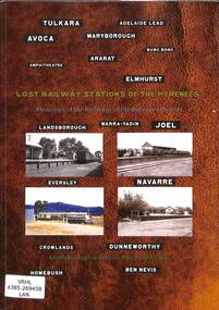
Book, Jeffrey, Max et al, Lost Railway Stations of the Pyrenees, 2019
... .) -- Buildings structures etc -- History Railroad stations -- Victoria -- Pyrenee Range -- History Illustrated history of the railway stations on the closed railway lines of the Victorian Pyrenees including the line to Navarre & Ararat to Maryborough. ill, maps, p.226. Lost Railway Stations of the Pyrenees Book Jeffrey, Max Leslie, Brett Landsborough & District Historical Group ...Illustrated history of the railway stations on the closed railway lines of the Victorian Pyrenees including the line to Navarre & Ararat to Maryborough.ill, maps, p.226.non-fictionIllustrated history of the railway stations on the closed railway lines of the Victorian Pyrenees including the line to Navarre & Ararat to Maryborough.pyrenee range (vic.) -- buildings, structures, etc -- history, railroad stations -- victoria -- pyrenee range -- history -
 Victorian Railway History Library
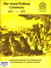
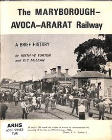
Book, Turton, Keith et al, The Ararat Railway Centenary 1875-1975, 1975
... The book was issued by the Australian Railway Historical Society, Victorian Division on the occasion of the Centenary Celebrations of the opening of the railway to Ararat on the 5th April 1875. ill, maps, p.60. The Ararat Railway Centenary 1875-1975 Book Turton, Keith Banfield, Miss L. ...A history of the Ballarat to Ararat railway in western Victoria and a lineside guide to the stations on the line. The book was issued by the Australian Railway Historical Society, Victorian Division on the occasion of the Centenary Celebrations of the opening of the railway to Ararat on the 5th April 1875.ill, maps, p.60.non-fictionA history of the Ballarat to Ararat railway in western Victoria and a lineside guide to the stations on the line. The book was issued by the Australian Railway Historical Society, Victorian Division on the occasion of the Centenary Celebrations of the opening of the railway to Ararat on the 5th April 1875.railroad construction - victoria - history, railway services: ballarat-ararat railway. victoria. ararat region -
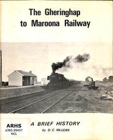 Victorian Railway History Library
Booklet, McLean, D.C, The Gheringhap to Maroona Railway, 1968
... Victorian Railway History Library 39 St Edmonds Rd Prahran Prahran Railroad construction - Victoria - history Railroads - Victoria - Gheringhap - history A history of the Victorian Railway's Gheringhap to Maroona Railway in western Victoria, complied to coincide with the Australian Railway Historical Society, Victorian Division's special train tour to Ararat via Cressy on the 15th September 1973. ill, maps, p.22. The Gheringhap to Maroona Railway Booklet McLean, D.C. ...A history of the Victorian Railway's Gheringhap to Maroona Railway in western Victoria, complied to coincide with the Australian Railway Historical Society, Victorian Division's special train tour to Ararat via Cressy on the 15th September 1973.ill, maps, p.22.non-fictionA history of the Victorian Railway's Gheringhap to Maroona Railway in western Victoria, complied to coincide with the Australian Railway Historical Society, Victorian Division's special train tour to Ararat via Cressy on the 15th September 1973.railroad construction - victoria - history, railroads - victoria - gheringhap - history -
 Beechworth Honey Archive
Hand-Drawn Map Centred on Armstrong by Frank Lebbell Frost Dec 1916
... Map...Armstrong...Ararat...Hand-drawn map centred on Armstrong, a town 6 miles from Ararat. Details vegetation along Great Western Highway. ...Hand Drawn Hand-Drawn Map Armstrong Ararat Frost Beekeeper Beechworth Honey Hand-drawn map centred on Armstrong, a town 6 miles from Ararat. ...This is one of the maps drawn by Frank L. Frost while he was beekeeping in North-East Victoria. This particular map may be reference in the "Wooden" Diary on page 11.Hand-drawn map centred on Armstrong, a town 6 miles from Ararat. Details vegetation along Great Western Highway. Drawn with black pen and grey lead on paper. Features are marked in red.hand drawn, hand-drawn, map, armstrong, ararat, frost, beekeeper, beechworth honey -
Lakes Entrance Historical Society
Book, Government Printer, Reports of the Mining Registrars for the quarter ended 31st December 1887, 1887
... Reports of the Mining Registrars for Mining Districts of Ballarat Beechworth Sandhurst Maryborough castlemaine Ararat and Gippsland to 31st December 1887 Geological details mine plans and maps are included....Lakes Entrance Historical Society 4 Marine Parade Lakes Entrance gippsland Mines and Mining Government Geographic Reports of the Mining Registrars for Mining Districts of Ballarat Beechworth Sandhurst Maryborough castlemaine Ararat and Gippsland to 31st December 1887 Geological details mine plans and maps are included. ...Reports of the Mining Registrars for Mining Districts of Ballarat Beechworth Sandhurst Maryborough castlemaine Ararat and Gippsland to 31st December 1887 Geological details mine plans and maps are included.mines and mining, government, geographic -
Stawell Historical Society Inc
Map, Crowlands & Navarre Railway Construction Trust, VR Plan Showing Railway Construction District Crowlands to navarre Line 1916, 4 July 1916
... Shire of Stawell Shire of Ararat 4 July 1916 Two (2) Very large Coloured Maps. Scale 40 Chains to 1 Inch. rail Line Drawn in Red VR Plan Showing Railway Construction District Crowlands to navarre Line 1916 Map Crowlands & Navarre Railway Construction Trust ...Two (2) Very large Coloured Maps. Scale 40 Chains to 1 Inch. rail Line Drawn in RedShire of Kara Kara. Shire of Stawell Shire of Ararat 4 July 1916railways -
Stawell Historical Society Inc
Map, Plan of Division Line between Ararat and Stawell Shires 1877, 1877
... Stawell Historical Society Inc 46 Longfield St Stawell grampians Grampians Halls Gap Black Range Stawell Shire Ararat Shire Crowlands Township Survey Examined by H.C. Malcolm 28.12.77 Traced By D.H. Meike 28.12.77 Very Large Map Printed on Linen with Table of bearings Plan of Division Line between Ararat and Stawell Shires 1877 Map ...Grampians Halls Gap Black Range Stawell Shire Ararat Shire Crowlands TownshipVery Large Map Printed on Linen with Table of bearingsExamined by H.C. Malcolm 28.12.77 Traced By D.H. Meike 28.12.77survey -
 Victorian Aboriginal Corporation for Languages
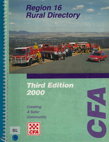
Map, Country Fire Authority, Region 16 rural directory, 2000
... Victorian Aboriginal Corporation for Languages 33 Saxon Street Brunswick melbourne Ararat fire protection emergency services maps Victorian regional maps maps, colour photographs Region 16 rural directory Map Country Fire Authority ...maps, colour photographsararat, fire protection, emergency services, maps, victorian regional maps -
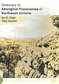 Victorian Aboriginal Corporation for Languages
Book, Ian D Clark et al, Dictionary of Aboriginal placenames of Northwest Victoria, 2002
... Victorian Aboriginal Corporation for Languages 33 Saxon Street Brunswick melbourne Grampians Hindmarsh Horsham Ararat Gannawarra Mildura Swan Hill Glenelg Djabwurrung Djadjawurrung Jardwadjali Dadidadi Wergaia Wembawemba Barababaraba Wadi Wadi Wathawurrung Ladji Ladji maps, b&w photographs Dictionary including Indigenous and European place names. ...Dictionary including Indigenous and European place names. Origins are given.maps, b&w photographsgrampians, hindmarsh, horsham, ararat, gannawarra, mildura, swan hill, glenelg, djabwurrung, djadjawurrung, jardwadjali, dadidadi, wergaia, wembawemba, barababaraba, wadi wadi, wathawurrung, ladji ladji -
Koorie Heritage Trust
Book, Banfield, Lorna. L, Shire of Ararat Centenary: It's settlement and development 1864-1964, 1964
... Koorie Heritage Trust Levels 1 & 3, Yarra Building Federation Square, Melbourne melbourne Ararat Shire-History 5-78 p.; ports; tables; maps; bib.; 25 cm. Shire of Ararat Centenary: It's settlement and development 1864-1964 Book Banfield, Lorna. ...5-78 p.; ports; tables; maps; bib.; 25 cm.ararat shire-history -
Koorie Heritage Trust
Book, Banfield, Lorna. L, Green Pastures and Gold: A history of Ararat, 1974
... Ararat District-conflict-social life and customs-Bunjil's Cave| place names- weapons and implements-hunting Early contacts between Thomas Mitchell and Aboriginal peoples and the later violent encounters involving settlers and squatters. The work and contacts of G.A. Robinson among the various peoples of the Western District. Gatherings of many Aboriginal peoples at Lake Bolac for eeling season, during which there was also trading of sandstone, obsidian and other materials for weapons and spears. Photograph of Jenny 'Ware' "the last of the Fiery Creek tribe of the Aboriginies" facing page 20. v-xi; 146 p.; ports;maps ...Early contacts between Thomas Mitchell and Aboriginal peoples and the later violent encounters involving settlers and squatters. The work and contacts of G.A. Robinson among the various peoples of the Western District. Gatherings of many Aboriginal peoples at Lake Bolac for eeling season, during which there was also trading of sandstone, obsidian and other materials for weapons and spears. Photograph of Jenny 'Ware' "the last of the Fiery Creek tribe of the Aboriginies" facing page 20.v-xi; 146 p.; ports;maps; index; bib.; appendics; footnotes; 22 cm.Early contacts between Thomas Mitchell and Aboriginal peoples and the later violent encounters involving settlers and squatters. The work and contacts of G.A. Robinson among the various peoples of the Western District. Gatherings of many Aboriginal peoples at Lake Bolac for eeling season, during which there was also trading of sandstone, obsidian and other materials for weapons and spears. Photograph of Jenny 'Ware' "the last of the Fiery Creek tribe of the Aboriginies" facing page 20.ararat -- victoria -- history |, aborigines, ararat district-conflict-social life and customs-bunjil's cave| place names- weapons and implements-hunting -
Stawell Historical Society Inc
Archive - CD/DVD, Historical Survey Maps of Ararat & Stawell - BMP's of all Images Scan of Book, 1/12/2005 12:00:00 AM
... Stawell Historical Society Inc 46 Longfield St Stawell grampians Stawell Historical Survey Maps of Ararat & Stawell - BMP's of all Images Scan of Book Archive CD/DVD ...stawell -
Stawell Historical Society Inc
Map, Special Surveys, District of Ararat, 1869
... Stawell Historical Society Inc 46 Longfield St Stawell grampians Stawell Special Surveys, District of Ararat Special Surveys, District of Ararat Map ...Special Surveys, District of Araratstawell -
Stawell Historical Society Inc
Map, Special Surveys, District of Ararat, 1968
... Stawell Historical Society Inc 46 Longfield St Stawell grampians stawell Special Surveys, District of Ararat Special Surveys, District of Ararat Map ...Special Surveys, District of Araratstawell -
 Victorian Railway History Library
Booklet, Turton, Keith et al, The Maryborough-Avoca-Ararat Railway: A Brief History, 1972
... Railroad construction - Victoria - history Maryborough to Ararat railway - history A brief history of the Maryborough to Avoca and Ararat railway in Victoria as part of Tour notes for a train trip run by the Australian Railway Historical Society Victorian Division on Saturday 11th November 1972. ill, maps, p16. ...A brief history of the Maryborough to Avoca and Ararat railway in Victoria as part of Tour notes for a train trip run by the Australian Railway Historical Society Victorian Division on Saturday 11th November 1972.ill, maps, p16.non-fictionA brief history of the Maryborough to Avoca and Ararat railway in Victoria as part of Tour notes for a train trip run by the Australian Railway Historical Society Victorian Division on Saturday 11th November 1972.railroad construction - victoria - history, maryborough to ararat railway - history -
 Stawell Historical Society Inc
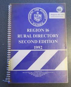
Book, Country Fire Authority, Region 16 Rural Directory, Second Edition 1992 - Country Fire Authority - Previously Cat No 3635, 1992
... A book of maps of region 16 for use by the CFA in bushfires stawell map Region 16 Rural Directory Second Edition 1992 Published by The Country Fire Authority Mapping Association INc. Sold by Country Fore Authority Regio 16 Headquarters 390 Barkly Street Ararat 3377 Clear Plastic cover with wire spiral binding, over pruple paper with CFA Logo and White Stripes in the lower half Region 16 Rural Directory, Second Edition 1992 - Country Fire Authority - Previously Cat No 3635 Book Country Fire Authority ...A book of maps of region 16 for use by the CFA in bushfires Clear Plastic cover with wire spiral binding, over pruple paper with CFA Logo and White Stripes in the lower halfRegion 16 Rural Directory Second Edition 1992 Published by The Country Fire Authority Mapping Association INc. Sold by Country Fore Authority Regio 16 Headquarters 390 Barkly Street Ararat 3377stawell map -
 Federation University Historical Collection
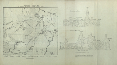
Map, Geological Sketch Map of of Dundas, Berung, and Ripon Counties
... map...geology...ararat...county of dundas county of berung county of ripon map geology ararat stawell hamilton grampians Map of the Counties of Dundas, Berung, and Ripon Geological Sketch Map of of Dundas, Berung, and Ripon Counties Map Map ...Map of the Counties of Dundas, Berung, and Riponcounty of dundas, county of berung, county of ripon, map, geology, ararat, stawell, hamilton, grampians -
Stawell Historical Society Inc
Map, Aerial Photomap of Stawell Airport 2
... Stawell West Top Left Airport Centre Right ARARAT 7423 Run 3 14750 Large B/W Photo Map Aerial Photomap of Stawell Airport 2 Map ...Stawell West Top Left Airport Centre RightLarge B/W Photo MapARARAT 7423 Run 3 14750