Showing 37 items matching "archaeological report"
-
 Bendigo Historical Society Inc.
Book - FORTUNA COLLECTION: ARCHAEOLOGICAL ASSESSMENT REPORT 2009, 2009
... FORTUNA COLLECTION: ARCHAEOLOGICAL ASSESSMENT REPORT 2009...Fortuna Bendigo Archaeological Assessment Final Report, prepared for the Department of Defence January 2009 by Godden Mackay Logan Heritage Consultants 105 pages with maps, plans & photographs....Book FORTUNA COLLECTION: ARCHAEOLOGICAL ASSESSMENT REPORT 2009 ...Fortuna Bendigo Archaeological Assessment Final Report, prepared for the Department of Defence January 2009 by Godden Mackay Logan Heritage Consultants 105 pages with maps, plans & photographs.Godden Mackay Logan Heritage Consultantsbuildings, house, fortuna -
 Tatura Irrigation & Wartime Camps Museum
Document - Folder, Camp 1 Conservation Report, 1993
... ...Archaeological report...Archaeological report prepared as part of post graduate studies....Tatura Irrigation & Wartime Camps Museum 49 Hogan Street Tatura the-murray Archaeological report prepared as part of post graduate studies. camp 1 reports Conservation report camp 1 Camp 1 Tatura Archaeological report Camp 1 Conservation Report Green plastic side bound folder containing approx. 50 A4 pages of text, photos and sketches. ...Archaeological report prepared as part of post graduate studies.Green plastic side bound folder containing approx. 50 A4 pages of text, photos and sketches.Camp 1 Conservation Reportcamp 1, reports, conservation report camp 1, camp 1 tatura, archaeological report -
Tatura Irrigation & Wartime Camps Museum
Document - Folder, Camp 1 Conservation Report (copy), 1993
... ...archaeological report...Copy of C0705. Archaeological report prepared as part of post graduate studies....Tatura Irrigation & Wartime Camps Museum 49 Hogan Street Tatura the-murray Copy of C0705. Archaeological report prepared as part of post graduate studies. camp 1 reports conservation report camp 1 camp 1 tatura archaeological report Black folder containing approx. 50 A4 pages of text, photos and sketches. ...Copy of C0705. Archaeological report prepared as part of post graduate studies.Black folder containing approx. 50 A4 pages of text, photos and sketches.camp 1, reports, conservation report camp 1, camp 1 tatura, archaeological report -
 The Beechworth Burke Museum
Photograph, 25 October 1930
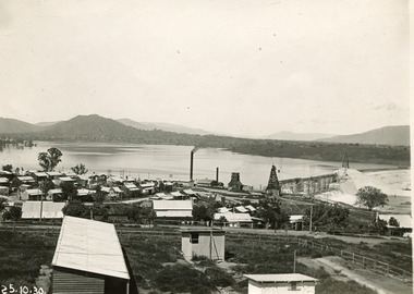
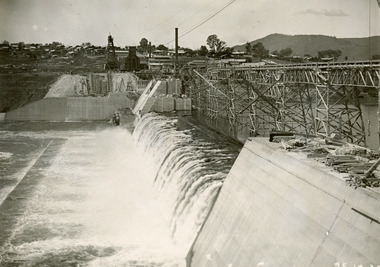
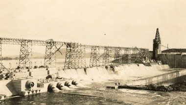
... Archaeological surveys were completed by Austral Archaeology, which was done when the Department of Land & Water Conservation was doing work to improve Hume Dam. The archaeological report that came out of the survey recommended three sites of interest where archaeological excavation should be done: Camp Ganger’s Quarters, Stableman’s Quarters, and the Industrial Dump. ...Archaeological surveys were completed by Austral Archaeology, which was done when the Department of Land & Water Conservation was doing work to improve Hume Dam. The archaeological report that came out of the survey recommended three sites of interest where archaeological excavation should be done: Camp Ganger’s Quarters, Stableman’s Quarters, and the Industrial Dump. ...Taken on 25 October 1930, various houses with the Hume Dam under construction are depicted in the background. The construction of the Hume Dam took place from 1919 to 1936. At the time of construction, it was the second largest dam in the world. It was also one of the earliest civil projects developed after the Federation. Some of the Dam workers consisted of World War I veterans. Dam workers often settled their families in Mitta Junction Village and Wodonga. Archaeological surveys were completed by Austral Archaeology, which was done when the Department of Land & Water Conservation was doing work to improve Hume Dam. The archaeological report that came out of the survey recommended three sites of interest where archaeological excavation should be done: Camp Ganger’s Quarters, Stableman’s Quarters, and the Industrial Dump. The excavation uncovered artefacts. Mitta Mitta: Mitta Mitta is situated between Mount Welcome and Mount Misery. It is named after the river that explorers Hume and Hovell discovered in 1824. The town would eventually become a huge gold mining town. Mitta Mitta is called Midamodunga by the local Indigenous peoples Wodonga: Wodonga is situated on the Murray River and is part of North East Victoria. Hume and Hovell: Hamilton Hume (1979-1873) and William Hilton Hovell (1786-1875). W. H. Hovell was born in Norfolk England and Hume was born in Parramatta, New South Wales Hovell and Hume undertook an exploration journey in 1824 and thought they discovered a river, which turned out to be the Murray River. They returned home in 1825, but returned to the area in 1826 and discovered coal in the area. This photo is historically significant as it shows the Hume Dam under construction in 1930. The Dam was named after Hamilton Hume, who is an important historical figure for this area as he helped discover the area where resources were found. Black and white rectangular photograph printer unmountedReverse: 1997.3145/ 84-20-2construction, houses, veterans, mitta junction village, hume dam, world war i, federation, wodonga, archaeological survey, excavation, austral archaeology, department of land & water conservation, camp ganger's quarter's, stableman's quarters, industrial dump, artefacts, mitta mitta, mount welcome, mount misery, murray river, hamilton hume, william hilton hovell, hume and hovell expedition -
 The Beechworth Burke Museum
Photograph, 25 October 1930
... Archaeological surveys were completed by Austral Archaeology, which was done when the Department of Land & Water Conservation was doing work to improve Hume Dam. The archaeological report that came out of the survey recommended three sites of interest where archaeological excavation should be done: Camp Ganger’s Quarters, Stableman’s Quarters, and the Industrial Dump. ...Archaeological surveys were completed by Austral Archaeology, which was done when the Department of Land & Water Conservation was doing work to improve Hume Dam. The archaeological report that came out of the survey recommended three sites of interest where archaeological excavation should be done: Camp Ganger’s Quarters, Stableman’s Quarters, and the Industrial Dump. ...Taken on 25 October 1930, various houses with the Hume Dam under construction are depicted in the background. The construction of the Hume Dam took place from 1919 to 1936. At the time of construction, it was the second largest dam in the world. It was also one of the earliest civil projects developed after the Federation. Some of the Dam workers consisted of World War I veterans. Dam workers often settled their families in Mitta Junction Village and Wodonga. Archaeological surveys were completed by Austral Archaeology, which was done when the Department of Land & Water Conservation was doing work to improve Hume Dam. The archaeological report that came out of the survey recommended three sites of interest where archaeological excavation should be done: Camp Ganger’s Quarters, Stableman’s Quarters, and the Industrial Dump. The excavation uncovered artefacts. Mitta Mitta: Mitta Mitta is situated between Mount Welcome and Mount Misery. It is named after the river that explorers Hume and Hovell discovered in 1824. The town would eventually become a huge gold mining town. Mitta Mitta is called Midamodunga by the local Indigenous peoples Wodonga: Wodonga is situated on the Murray River and is part of North East Victoria. Hume and Hovell: Hamilton Hume (1979-1873) and William Hilton Hovell (1786-1875). W. H. Hovell was born in Norfolk England and Hume was born in Parramatta, New South Wales Hovell and Hume undertook an exploration journey in 1824 and thought they discovered a river, which turned out to be the Murray River. They returned home in 1825, but returned to the area in 1826 and discovered coal in the area.This photo is historically significant as it shows the Hume Dam under construction in 1930. The Dam was named after Hamilton Hume, who is an important historical figure for this area as he helped discover the area where resources were found.Black and white rectangular photograph printer unmountedReverse: 84-20-1/ 1997.3147construction, houses, veterans, mitta junction village, hume dam, world war i, federation, wodonga, archaeological survey, excavation, austral archaeology, department of land & water conservation, camp ganger's quarter's, stableman's quarters, industrial dump, artefacts, mitta mitta, mount welcome, mount misery, murray river, hamilton hume, william hilton hovell, hume and hovell expedition -
 The Beechworth Burke Museum
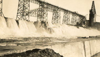
Photograph
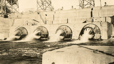
... Archaeological surveys were completed by Austral Archaeology, which was done when the Department of Land & Water Conservation was doing work to improve Hume Dam. The archaeological report that came out of the survey recommended three sites of interest where archaeological excavation should be done: Camp Ganger’s Quarters, Stableman’s Quarters, and the Industrial Dump. ...Archaeological surveys were completed by Austral Archaeology, which was done when the Department of Land & Water Conservation was doing work to improve Hume Dam. The archaeological report that came out of the survey recommended three sites of interest where archaeological excavation should be done: Camp Ganger’s Quarters, Stableman’s Quarters, and the Industrial Dump. ...Taken on 25 October 1930, various houses with the Hume Dam under construction are depicted in the background. The construction of the Hume Dam took place from 1919 to 1936. At the time of construction, it was the second largest dam in the world. It was also one of the earliest civil projects developed after the Federation. Some of the Dam workers consisted of World War I veterans. Dam workers often settled their families in Mitta Junction Village and Wodonga. Archaeological surveys were completed by Austral Archaeology, which was done when the Department of Land & Water Conservation was doing work to improve Hume Dam. The archaeological report that came out of the survey recommended three sites of interest where archaeological excavation should be done: Camp Ganger’s Quarters, Stableman’s Quarters, and the Industrial Dump. The excavation uncovered artefacts. Mitta Mitta: Mitta Mitta is situated between Mount Welcome and Mount Misery. It is named after the river that explorers Hume and Hovell discovered in 1824. The town would eventually become a huge gold mining town. Mitta Mitta is called Midamodunga by the local Indigenous peoples Wodonga: Wodonga is situated on the Murray River and is part of North East Victoria. Hume and Hovell: Hamilton Hume (1979-1873) and William Hilton Hovell (1786-1875). W. H. Hovell was born in Norfolk England and Hume was born in Parramatta, New South Wales Hovell and Hume undertook an exploration journey in 1824 and thought they discovered a river, which turned out to be the Murray River. They returned home in 1825, but returned to the area in 1826 and discovered coal in the area. This photo is historically significant as it shows the Hume Dam under construction in 1930. The Dam was named after Hamilton Hume, who is an important historical figure for this area as he helped discover the area where resources were found.Sepia rectangular photograph printed unmountedReverse: 84-19-5 / 1997.3185/ Values & spillway. / When completed the wall / will be as high as the / scaffolding. [featuring trademark: kodak print]construction, houses, veterans, mitta junction village, hume dam, world war i, federation, wodonga, archaeological survey, excavation, austral archaeology, department of land & water conservation, camp ganger's quarter's, stableman's quarters, industrial dump, artefacts, mitta mitta, mount welcome, mount misery, murray river, hamilton hume, william hilton hovell, hume and hovell expedition -
 The Beechworth Burke Museum
Photograph, c1930
... Archaeological surveys were completed by Austral Archaeology, which was done when the Department of Land & Water Conservation was doing work to improve Hume Dam. The archaeological report that came out of the survey recommended three sites of interest where archaeological excavation should be done: Camp Ganger’s Quarters, Stableman’s Quarters, and the Industrial Dump. ...Archaeological surveys were completed by Austral Archaeology, which was done when the Department of Land & Water Conservation was doing work to improve Hume Dam. The archaeological report that came out of the survey recommended three sites of interest where archaeological excavation should be done: Camp Ganger’s Quarters, Stableman’s Quarters, and the Industrial Dump. ...Taken on 25 October 1930, various houses with the Hume Dam under construction are depicted in the background. The construction of the Hume Dam took place from 1919 to 1936. At the time of construction, it was the second largest dam in the world. It was also one of the earliest civil projects developed after the Federation. Some of the Dam workers consisted of World War I veterans. Dam workers often settled their families in Mitta Junction Village and Wodonga. Archaeological surveys were completed by Austral Archaeology, which was done when the Department of Land & Water Conservation was doing work to improve Hume Dam. The archaeological report that came out of the survey recommended three sites of interest where archaeological excavation should be done: Camp Ganger’s Quarters, Stableman’s Quarters, and the Industrial Dump. The excavation uncovered artefacts. Mitta Mitta: Mitta Mitta is situated between Mount Welcome and Mount Misery. It is named after the river that explorers Hume and Hovell discovered in 1824. The town would eventually become a huge gold mining town. Mitta Mitta is called Midamodunga by the local Indigenous peoples Wodonga: Wodonga is situated on the Murray River and is part of North East Victoria. Hume and Hovell: Hamilton Hume (1979-1873) and William Hilton Hovell (1786-1875). W. H. Hovell was born in Norfolk England and Hume was born in Parramatta, New South Wales Hovell and Hume undertook an exploration journey in 1824 and thought they discovered a river, which turned out to be the Murray River. They returned home in 1825, but returned to the area in 1826 and discovered coal in the area.This photo is historically significant as it shows the Hume Dam under construction in 1930. The Dam was named after Hamilton Hume, who is an important historical figure for this area as he helped discover the area where resources were found.Sepia rectangular photograph printed unmountedReverse: 84-19-2/ 1997.3188/ These are the four / release valves they are / not always open (illegible) this / when closed the water flows / over the spillway. [featuring trademark: kodak print] photograph number: 354construction, houses, veterans, mitta junction village, hume dam, world war i, federation, wodonga, archaeological survey, excavation, austral archaeology, department of land & water conservation, camp ganger's quarter's, stableman's quarters, industrial dump, artefacts, mitta mitta, mount welcome, mount misery, murray river, hamilton hume, william hilton hovell, hume and hovell expedition -
 The Beechworth Burke Museum
Photograph, 25 October 1930
... Archaeological surveys were completed by Austral Archaeology, which was done when the Department of Land & Water Conservation was doing work to improve Hume Dam. The archaeological report that came out of the survey recommended three sites of interest where archaeological excavation should be done: Camp Ganger’s Quarters, Stableman’s Quarters, and the Industrial Dump. ...Archaeological surveys were completed by Austral Archaeology, which was done when the Department of Land & Water Conservation was doing work to improve Hume Dam. The archaeological report that came out of the survey recommended three sites of interest where archaeological excavation should be done: Camp Ganger’s Quarters, Stableman’s Quarters, and the Industrial Dump. ...Taken on 25 October 1930, various houses with the Hume Dam under construction are depicted in the background. The construction of the Hume Dam took place from 1919 to 1936. At the time of construction, it was the second largest dam in the world. It was also one of the earliest civil projects developed after the Federation. Some of the Dam workers consisted of World War I veterans. Dam workers often settled their families in Mitta Junction Village and Wodonga. Archaeological surveys were completed by Austral Archaeology, which was done when the Department of Land & Water Conservation was doing work to improve Hume Dam. The archaeological report that came out of the survey recommended three sites of interest where archaeological excavation should be done: Camp Ganger’s Quarters, Stableman’s Quarters, and the Industrial Dump. The excavation uncovered artefacts. Mitta Mitta: Mitta Mitta is situated between Mount Welcome and Mount Misery. It is named after the river that explorers Hume and Hovell discovered in 1824. The town would eventually become a huge gold mining town. Mitta Mitta is called Midamodunga by the local Indigenous peoples Wodonga: Wodonga is situated on the Murray River and is part of North East Victoria. Hume and Hovell: Hamilton Hume (1979-1873) and William Hilton Hovell (1786-1875). W. H. Hovell was born in Norfolk England and Hume was born in Parramatta, New South Wales Hovell and Hume undertook an exploration journey in 1824 and thought they discovered a river, which turned out to be the Murray River. They returned home in 1825, but returned to the area in 1826 and discovered coal in the area.This photo is historically significant as it shows the Hume Dam under construction in 1930. The Dam was named after Hamilton Hume, who is an important historical figure for this area as he helped discover the area where resources were found.Sepia rectangular photograph printed unmountedReverse: 84-19-6/ 1997.3187/ The spillway [featuring trademark: kodak print] construction, houses, veterans, mitta junction village, hume dam, world war i, federation, wodonga, archaeological survey, excavation, austral archaeology, department of land & water conservation, camp ganger's quarter's, stableman's quarters, industrial dump, artefacts, mitta mitta, mount welcome, mount misery, murray river, hamilton hume, william hilton hovell, hume and hovell expedition -
 Orbost & District Historical Society
book, A History of the Aboriginal people of East Gippsland by Kym Thompson, January, 1985
... It is a report for the Land Conservation Council, Victoria, 1985. Contains archaeological research, history of white invasion and matters related to the preservation of sites of significance in the area. 284pp....It is a report for the Land Conservation Council, Victoria, 1985. Contains archaeological research, history of white invasion and matters related to the preservation of sites of significance in the area. 284pp. ...A manuscript book with a pink cover. A History of the Aboriginal People of East Gippsland by Kym Thompson. It is a report for the Land Conservation Council, Victoria, 1985. Contains archaeological research, history of white invasion and matters related to the preservation of sites of significance in the area. 284pp.book australian-aborigines land-conservation-council thompson-kym -
 Flagstaff Hill Maritime Museum and Village
Photograph, post 1889
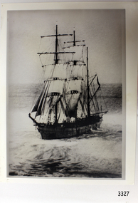
... The report from SHP documented the following in regards to the Newfield collection: Flagstaff Hill’s collection of artefacts from the Newfield is of historical and archaeological significance at a State level, because of its association with the shipwreck, which is on the Victorian Heritage Register. ...The photograph shows the three-masted iron and steel bark "Newfield" sailing in open seas. It event would have been between 1889-1892 during the ship's working life. ABOUT THE NEWFIELD The Newfield was a three-masted iron and steel barque, built in Dundee, Scotland, in 1889 by Alexander Stephen and Sons. It was owned by the Newfield Ship Company in 1890 and later that year It was registered in Liverpool to owners Brownells and Co. The Newfield left Sharpness, Scotland, on 28th May 1892 with a crew of 25 under the command of Captain George Scott and on 1st June left Liverpool. She was bound for Brisbane, Australia, with a cargo of 1850 tons of fine rock salt, the main export product of Sharpness. At about 9pm on 28th August 1892, in heavy weather, Captain Scott sighted, between heavy squalls, the Cape Otway light on the mainland of Victoria but, due to a navigational error (the ship’s chronometers were wrong), he assumed it to be the Cape Wickham light on King Island, some 40 miles south. He altered his course to the north, expecting to enter Bass Strait. The ship was now heading straight for the south west Victorian coast and at about 1:30am ran aground on a reef about 100 yards from shore and one mile east of Curdie’s Inlet, Peterborough. The ship struck heavily three times before grounding on an inner shoal with 6 feet of water in the holds. Rough sea made the job of launching lifeboats very difficult. The first two lifeboats launched by the crew were smashed against the side of the ship and some men were crushed or swept away. The third lifeboat brought eight men to shore. It capsized when the crew tried to return it to the ship for further rescue The Port Campbell rocket crew arrived and fired four rocket lines, none of which connected with the ship. A local man, Peter Carmody, volunteered to swim one mile to the ship with a line to guide the fourth and final lifeboat safely to shore. Seventeen men survived the shipwreck but the captain and eight of his crew perished. One of the men, apprentice William McLeod, was rescued by local woman Margaret E. MacKenzie. The Newfield remained upright on the reef with sails set for a considerable time as the wind slowly ripped the canvas to shreds and the sea battered the hull to pieces. The Marine Board inquiry found the wreck was caused by a "one man style of navigation" and that the Captain had not heeded the advice of his crew. According to Jack Loney ‘… when the drama was over . . the Newfield was deserted except for the Captain’s dog and two pigs.’ Flagstaff Hill Maritime Museum has several artefacts that have been salvaged from the wreck. The report from SHP documented the following in regards to the Newfield collection: Flagstaff Hill’s collection of artefacts from the Newfield is of historical and archaeological significance at a State level, because of its association with the shipwreck, which is on the Victorian Heritage Register. The collection is significant because of its relationship between the objects. The Newfield collection is archaeologically significant as it is the remains of an international cargo ship. The Newfield collection is historically significant for representing aspects of Victoria’s shipping history and its potential to interpret sub-theme 1.5 (Living with natural processes). The collection is also historically significant for its association with the shipwreck. Black and white photograph of the three-masted sailing ship “Newfield” in the open sea, sails unfurled. The ship was built in 1859 by Alexander Stephen and Sons Limited of Dundee, Scotland. flagstaff hill, warrnambool, shipwrecked-coast, flagstaff-hill, flagstaff-hill-maritime-museum, maritime-museum, shipwreck-coast, flagstaff-hill-maritime-village, barque newfield, photograph, 1880s sailing ship -
 Bendigo Historical Society Inc.
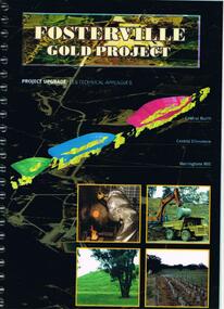
Document - FOSTERVILLE GOLD MINE COLLECTION: PROJECT UPGRADE TECHNICAL APPENDICES
... report. On front: "Fosterville Gold Project' Project upgrade, EES Technical Appendix B. Central North, Central Ellesmere, Harringtons Hill." Page 1 'Perseverance Exploration Pty Limited' Book contains technical appendices. Topics: hydro geological assessment; surface drainage study, noise emission to residential properties, flora survey, tailings dam site; flora survey Wellesford Forest; Daley's Hill Plant List; diurnal Avifauna Survey - Wellesford Forest; survey of vertebrate fauna - Wellesford Forest; brief summary of fauna - Daley's Hill, Axedale, Aboriginal Archaeological survey; archaeological investigation Fosterville; traffic survey - Fosterville Sulphide Project; traffic report....report. On front: "Fosterville Gold Project' Project upgrade, EES Technical Appendix B. Central North, Central Ellesmere, Harringtons Hill." Page 1 'Perseverance Exploration Pty Limited' Book contains technical appendices. Topics: hydro geological assessment; surface drainage study, noise emission to residential properties, flora survey, tailings dam site; flora survey Wellesford Forest; Daley's Hill Plant List; diurnal Avifauna Survey - Wellesford Forest; survey of vertebrate fauna - Wellesford Forest; brief summary of fauna - Daley's Hill, Axedale, Aboriginal Archaeological survey; archaeological investigation Fosterville; traffic survey - Fosterville Sulphide Project; traffic report. ...Black cover book, wire binding. Pages in reports numbered individually, overall approx 250 page report. On front: "Fosterville Gold Project' Project upgrade, EES Technical Appendix B. Central North, Central Ellesmere, Harringtons Hill." Page 1 'Perseverance Exploration Pty Limited' Book contains technical appendices. Topics: hydro geological assessment; surface drainage study, noise emission to residential properties, flora survey, tailings dam site; flora survey Wellesford Forest; Daley's Hill Plant List; diurnal Avifauna Survey - Wellesford Forest; survey of vertebrate fauna - Wellesford Forest; brief summary of fauna - Daley's Hill, Axedale, Aboriginal Archaeological survey; archaeological investigation Fosterville; traffic survey - Fosterville Sulphide Project; traffic report.bendigo, mining, fosterville gold mine, hydro geological assessment, surface drainage study, noise emission to residential properties, flora survey, tailings dam site, flora survey wellesford forest, daley's hill plant list, diurnal avifauna survey - wellesford forest, survey of vertebrate fauna - wellesford forest, brief summary of fauna - daley's hill, axedale, aboriginal archaeological survey, archaeological investigation fosterville, traffic survey - fosterville sulphide project, traffic report. -
 Queenscliffe Maritime Museum
Document - Diary of John Clarke 1850 to 1883, John Clarke, Personal diary of John Clarke, 1850 to 1883
... reported to Heritage Victoria as located on the 15th January 2003 by Peter Ferrier and Don Love. As the site is over 75 years old it is automatically protected under the Commonwealth Historic Shipwrecks Act 1976. This diary is important as it outlines the eye witness account of the last moments of the Barque Columbine which is primarily of historic, technical, social and archaeological significance internationally and to the State of Victoria. ...The wreck site identified as the Columbine, a two masted brig built in 1839 in Aberdeen, Scotland and wrecked on the 1st April 1854 at Ocean Grove, Victoria, was formally reported to Heritage Victoria as located on the 15th January 2003 by Peter Ferrier and Don Love. As the site is over 75 years old it is automatically protected under the Commonwealth Historic Shipwrecks Act 1976. This diary is important as it outlines the eye witness account of the last moments of the Barque Columbine which is primarily of historic, technical, social and archaeological significance internationally and to the State of Victoria. It is a unique original account of that episode in early migrant history of Victoria and of Australia.A small leather bound black diary containing entries by John Clarke from 1843 to 1883, recording aspects of his life in Australia from the wreck of the Colombine as a child [approx 13 y.o.a.] to his experiences working in the gold fields and around the Geelong area. The diary is extensively damaged.john clarke, barque colombine, approaches to port phillip, ship wrecks, south coast -
 Queenscliffe Maritime Museum
Functional object - Doors
... reported as a result of the Commonwealth Amnesty held in 1993-94. These are the Loch Ard (1878), Schomberg (1855) and Fiji (1891) - all situated along the western district 'Shipwreck Coast' - and the George Roper (1883), Light of the Age (1868), Joseph H. Scammell (1891) and Victoria Tower - all situated along the short section of the 'Surf Coast' between Point Lonsdale and Torquay. The Victoria Tower is archaeologically ...There are only seven shipwrecks in Victoria that have had more than 100 objects recovered from them reported as a result of the Commonwealth Amnesty held in 1993-94. These are the Loch Ard (1878), Schomberg (1855) and Fiji (1891) - all situated along the western district 'Shipwreck Coast' - and the George Roper (1883), Light of the Age (1868), Joseph H. Scammell (1891) and Victoria Tower - all situated along the short section of the 'Surf Coast' between Point Lonsdale and Torquay.The Victoria Tower is archaeologically significant as the wreck of an international inward-bound passenger and cargo vessel. It is educationally and recreationally significant as a coherently intact example of a British built iron clipper ie: representative of a class or type. Along with the wrecks of the Light of the Age (1868 - American-built wooden clipper ship) and Sussex (1871 - Blackwall frigate) nearby these vessels represent the three major design classes, and span the evolution of commercial and immigrant sailing ships used by the British in the colonial Australian trade in the last half of the nineteenth century.2 Doors from the 'Victoria Tower' made from teak and mahoganydoors, salvage, shipwreck, torquay, victoria tower -
 Australian Institute of Archaeology
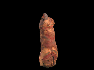
Mummified Cat, Charlie, Pre Ptolemaic - before 330BC
... Australian Institute of Archaeology Mont Park complex (near La Trobe University) Bundoora melbourne Neutron scans from ANSTO reveal that only portion of the animal, probably a cat, was wrapped in the mummy. Preliminary reports ...Neutron scans from ANSTO reveal that only portion of the animal, probably a cat, was wrapped in the mummy. Preliminary reports of C14 dating indicates that it dates from about 600BCE. It was discovered in the 1850s in Egypt. Many animals in ancient Egypt were deemed to represent a specific deity. Egyptologists have suggested that in the first millennium B.C. an act of popular piety was to place a mummified animal as a votive offering in a catacomb established at a cult center of that deity. Such an act may be expected to afford protection and bring good fortune. More recently, a close connection between the veneration of sacred animals and the worship of the king has been proposed, with the suggestion that these offerings were obligatory for religious officials and soldiers connected with certain royal cults. Interment of sacred animals was quite common in the Ptolemaic period (304-30 BCE) and continued well into the first half of the Roman period, or the second century CE. Cat cemeteries have been found throughout Egypt, and it is probably the Goddess, Bastet's association with her divine sisters in the wild, the malevolent Sakhmet and other lion-headed goddesses, that accounts for the presence of very large cat catacombs at Saqqara, Thebes, and Beni Hasan, where these leonine deities were particularly revered. There were several ways in which the cats were prepared for deposition; in the simplest cases the bodies were mummified and wrapped in linen strips, which were sometimes dyed different brown tones and woven to form geometric patterns. Usually the limbs were positioned close to the body, making a compact bundle but some mummies held lifelike poses. Egyptians considered certain individual animals to be living manifestations of a god, such as, the Apis bull. Individuals were mummified when they died and buried for eternal life, then replaced by another single living manifestation. Research on animal mummies shows that the majority of mummies found at the large animal cemetery sites are pre-adults who were purposely killed for use, sometimes by breaking the neck. Some mummies are 'substitutes' containing only a few bones or feathers or possibly sticks or sand. Mummified cat remains. -
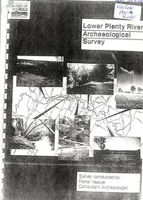 Greensborough Historical Society
Report, Lower Plenty River Archaeological Survey; Fiona Weaver, 1989_
... Lower Plenty River Archaeological Survey; Fiona Weaver Report ...Archaeological survey of the Lower Plenty River undertaken in 1989-1990 by Fiona Weaver for the Board of Works. Indigenous heritage sites along the Plenty River are examined and recommendations made for the preservation and to lessen the impact of development on these sites.Printed on white A4 paper. Approx 92 pages (not numbered). Illus., maps. 2 copies.plenty river, board of works, aboriginal heritage sites, fiona weaver -
 Flagstaff Hill Maritime Museum and Village
Machine - Pulley, Ca 1889
... The report from SHP documented the following in regards to the Newfield collection: Flagstaff Hill’s collection of artefacts from the Newfield is of historical and archaeological significance at a State level, because of its association with the shipwreck, which is on the Victorian Heritage Register. ...Wooden pulley wheel section from the wreck “Newfield”. The Newfield was a three-masted iron and steel barque, built in Dundee, Scotland, in 1889 by Alexander Stephen and Sons. It was owned by the Newfield Ship Company in 1890 and later that year It was registered in Liverpool to owners Brownells and Co. The Newfield left Sharpness, Scotland, on 28th May 1892 with a crew of 25 under the command of Captain George Scott and on 1st June left Liverpool. She was bound for Brisbane, Australia, with a cargo of 1850 tons of fine rock salt, the main export product of Sharpness. At about 9pm on 28th August 1892, in heavy weather, Captain Scott sighted, between heavy squalls, the Cape Otway light on the mainland of Victoria but, due to a navigational error (the ship’s chronometers were wrong), he assumed it to be the Cape Wickham light on King Island, some 40 miles south. He altered his course to the north, expecting to enter Bass Strait. The ship was now heading straight for the south west Victorian coast and at about 1:30am ran aground on a reef about 100 yards from shore and one mile east of Curdie’s Inlet, Peterborough. The ship struck heavily three times before grounding on an inner shoal with 6 feet of water in the holds. Rough sea made the job of launching lifeboats very difficult. The first two lifeboats launched by the crew were smashed against the side of the ship and some men were crushed or swept away. The third lifeboat brought eight men to shore. It capsized when the crew tried to return it to the ship for further rescue The Port Campbell rocket crew arrived and fired four rocket lines, none of which connected with the ship. A local man, Peter Carmody, volunteered to swim one mile to the ship with a line to guide the fourth and final lifeboat safely to shore. Seventeen men survived the shipwreck but the captain and eight of his crew perished. The Newfield remained upright on the reef with sails set for a considerable time as the wind slowly ripped the canvas to shreds and the sea battered the hull to pieces. The Marine Board inquiry found the wreck was caused by a "one man style of navigation" and that the Captain had not heeded the advice of his crew. According to Jack Loney ‘… when the drama was over . . the Newfield was deserted except for the Captain’s dog and two pigs.’ Flagstaff Hill Maritime Museum has several artefacts that have been salvaged from the wreck. See also other items in the Flagstaff Hill Newfield Collection.The report from SHP documented the following in regards to the Newfield collection: Flagstaff Hill’s collection of artefacts from the Newfield is of historical and archaeological significance at a State level, because of its association with the shipwreck, which is on the Victorian Heritage Register. The collection is significant because of its relationship between the objects. The Newfield collection is archaeologically significant as it is the remains of an international cargo ship. The Newfield collection is historically significant for representing aspects of Victoria’s shipping history and its potential to interpret sub-theme 1.5 (Living with natural processes). The collection is also historically significant for its association with the shipwreck. The Newfield collection meets the following criteria for assessment: Criteria A: Importance to the course, or pattern, of Victoria’s cultural history Criteria B: Possession of uncommon, rare or endangered aspects of Victoria’s cultural history Criteria C: Potential to yield information that will contribute to an understanding of Victoria’s cultural history This item is an oval-shaped brown and orange wooden shell from a ship’s pulley. The original wooden material is now petrified but the lighter coloured concentric rings of the wood's grain are still visible. A metal sheave or drum is fitted into the centre hole and some of the edge of its sheave’s collar has corroded and broken away. The collar has three holes of equal size that are evenly spaced around it. The bearing ring is now detached but still connected to the pulley with a string on which a label is attached. Most of the six cylindrical metal roller bearings are sand encrusted but some are still visible. Recovered from the wreck of the ship NEWFIELD.The pulley has a string through it that attaches it to the bearing. The label on the string bears the handwritten words “PULLEY WHEEL / NEWFIELD / PETER ROLAND”.block, flagstaff hill, maritime museum, shipwreck coast, warrnambool, peter carmody, carmody, newfield, shipwreck, pulley, wheel, pulley block, sheave, drum, peterborough, south west victoria, rocket, rocket crew, shipwreck artefact, flagstaff hil maritime museum -
 Flagstaff Hill Maritime Museum and Village
Document - Report, Jet Probings, Warrnambool Harbour, 16-10-1929
... This report lists the depths of water and the consistency of the seabed surrounding the Warrnambool Harbour in October 1929, The information, often referred to as 'soundings', was obtained by Jet Probing,. In earlier days a lead line was used to perform a similar task. The author of the document is unknown. Jet Probing is a method used for underwater archaeology...Flagstaff Hill Maritime Museum and Village 89 Merri Street Warrnambool great-ocean-road This report lists the depths of water and the consistency of the seabed surrounding the Warrnambool Harbour in October 1929, The information, often referred to as 'soundings', was obtained by Jet Probing,. In earlier days a lead line was used to perform a similar task. The author of the document is unknown. Jet Probing is a method used for underwater archaeology ...This report lists the depths of water and the consistency of the seabed surrounding the Warrnambool Harbour in October 1929, The information, often referred to as 'soundings', was obtained by Jet Probing,. In earlier days a lead line was used to perform a similar task. The author of the document is unknown. Jet Probing is a method used for underwater archaeology, cable installation and coastal engineering. A jet probe is a machine that produces a strong jet of water that penetrates the layers of sediment on the seabed, determining their depth, thickness and consistency. It provides a survey of the seabed and can be used as an aid to engineering design and construction. The report mentions lining up with the wooden jetty, the end of the breakwater and the leading lights. It mentions sand, loose rock and rock. It tells of stopping work due to the water being too rough, the pipe choking, difficulty in connecting pipes, and pipe joint breaking as it tried to get through the sand, The report in the document is significant for its connection with the Warrnambool Harbour, Warrnambool Breakwater, Warrnambool Jetty and Lady Bay. The report gives figures for the depth and consistency of the water and seabed at a particular point in time and can be used to compart with similar figures taken at different times. The results could determine plans for future engineering works.Report, titled 'Jet Probings, Warrnambool Harbour'. Two pages of cream coloured paper with hand written notes in pen and ink. Report covers three days of Jet Probings, with resulting figures and comments, for the depths of the surroundings of the Warrnambool Harbour. The report is in point form, with some underlining. Dates of recordings are 14-10-29, 15-10-29 and 16-10-29. (1929) The situation of the harbour had become a real problem by 1910 and required continuous dredging. In 1914 the Breakwater was extended but proved to be a failure because the work began to subside and by 1920 about two thirds of the harbour was silted up. Alterations made in the 1920's increased the silting problem. The soundings and Jet Probings were done after the Royal Commission of 1923, when the damaged stonework on the seaward side of the Warrnambool Breakwater, caused by the action of the sea, was the subject of enquiry. A conference between the Public Works, Water Commission and the Harbour Trust concluded that it would less costly to make repairs to prevent further damage rather than replaced the damage portion of the wall. A contract was raised in late 1924 to deposit rubble on the damaged side of the breakwater to minimise the Southern Ocean’s destructive action and work had started by August 1925. By the 1940's the harbour was no longer used. More alterations were made in the 1950's and 1960's. document, depth, warrnambool harbour, 1929, soundings, jet probe, jet probing, seabed, map of seabed, underwater engineering, warrnambool jetty, warrnambool breakwater, breakwater upgrade, leading lights, chart the harbour, flagstaff hill, warrnambool, flagstaff hill maritime museum & village, maritime museum, maritime village, shipwreck coast, lady bay, port of warrnambool, breakwater, jetty, pier, vhr h2024, royal commission, 1923, public works, water commission, harbour trust, victorian harbours -
 Flagstaff Hill Maritime Museum and Village
Handle, c. 1859
... A report from SHP documented the following in regards to the Newfield collection: Flagstaff Hill’s collection of artefacts from the Newfield is of historical and archaeological significance at a State level, because of its association with the shipwreck, which is on the Victorian Heritage Register. ...This brass handle was found on Sea Elephant Bay beach in King Island, Tasmania, in 1913. The donor identified it as being from the wreck of the Newfield. It would could have been part of the fittings or amongst the cargo on the ship. ABOUT THE "NEWFIELD" The Newfield was a three-masted iron and steel barque, built in Dundee, Scotland, in 1889 by Alexander Stephen and Sons. It was owned by the Newfield Ship Company in 1890 and later that year It was registered in Liverpool to owners Brownells and Co. The Newfield left Sharpness, Scotland, on 28th May 1892 with a crew of 25 under the command of Captain George Scott and on 1st June left Liverpool. She was bound for Brisbane, Australia, with a cargo of 1850 tons of fine rock salt, the main export product of Sharpness. At about 9pm on 28th August 1892, in heavy weather, Captain Scott sighted, between heavy squalls, the Cape Otway light on the mainland of Victoria but, due to a navigational error (the ship’s chronometers were wrong), he assumed it to be the Cape Wickham light on King Island, some 40 miles south. He altered his course to the north, expecting to enter Bass Strait. The ship was now heading straight for the south west Victorian coast and at about 1:30am ran aground on a reef about 100 yards from shore and one mile east of Curdie’s Inlet, Peterborough. The ship struck heavily three times before grounding on an inner shoal with 6 feet of water in the holds. Rough sea made the job of launching lifeboats very difficult. The first two lifeboats launched by the crew were smashed against the side of the ship and some men were crushed or swept away. The third lifeboat brought eight men to shore. It capsized when the crew tried to return it to the ship for further rescue The Port Campbell rocket crew arrived and fired four rocket lines, none of which connected with the ship. A local man, Peter Carmody, volunteered to swim one mile to the ship with a line to guide the fourth and final lifeboat safely to shore. Seventeen men survived the shipwreck but the captain and eight of his crew perished. One of the men, apprentice William McLeod, was rescued by local woman Margaret E. MacKenzie. The Newfield remained upright on the reef with sails set for a considerable time as the wind slowly ripped the canvas to shreds and the sea battered the hull to pieces. The Marine Board inquiry found the wreck was caused by a "one man style of navigation" and that the Captain had not heeded the advice of his crew. According to Jack Loney ‘… when the drama was over . . the Newfield was deserted except for the Captain’s dog and two pigs.’ Flagstaff Hill Maritime Museum has several artefacts that have been salvaged from the wreck. A report from SHP documented the following in regards to the Newfield collection: Flagstaff Hill’s collection of artefacts from the Newfield is of historical and archaeological significance at a State level, because of its association with the shipwreck, which is on the Victorian Heritage Register. The collection is significant because of its relationship between the objects. The Newfield collection is archaeologically significant as it is the remains of an international cargo ship. The Newfield collection is historically significant for representing aspects of Victoria’s shipping history and its potential to interpret sub-theme 1.5 (Living with natural processes). The collection is also historically significant for its association with the shipwreck. The Newfield collection meets the following criteria for assessment: Criteria A: Importance to the course, or pattern, of Victoria’s cultural history Criteria B: Possession of uncommon, rare or endangered aspects of Victoria’s cultural history Criteria C: Potential to yield information that will contribute to an understanding of Victoria’s cultural history Ornate brass handle, round plates each end, each with 4 round fixing holes. Found washed up on Sea Elephant Bay beach, King Island 1913, identified by donor as being from the wreck of the Newfield.flagstaff hill, warrnambool, shipwrecked-coast, flagstaff-hill, flagstaff-hill-maritime-museum, maritime-museum, barque newfield, shipwreck-coast, flagstaff-hill-maritime-village, ornate handle, sailing ship fitting, sea elephant bay, king island -
 Federation University Historical Collection
Book - Report, Camp Street Precinct Ballarat Conservation Management Plan, November 1999
... Barker Library (top floor) Mount Helen goldfields This report was prepared for the City of Ballarat to assist in the process of planning for the future management and development of the Camp Street precinct. ballarat fine art gallery Art Gallery of Ballarat ballarat old colonists hall ballarat former library ballarat old court house old ballarat police station former ballarat post office ballarat market reserve ballarat benevolent reserve bones building old colonists hall former ballarat call room former ballarat police court archaeology aledandria tea room former lister and angel warehouse pratts warehouse cms conservation management plan Old Colonists' Hall Old Colonists' Association 214 page report with spiral binding and a cover featuring a black and white image of the Ballarat Post Office, Ballarat Free Library and Ballarat State Offices. ...This report was prepared for the City of Ballarat to assist in the process of planning for the future management and development of the Camp Street precinct.214 page report with spiral binding and a cover featuring a black and white image of the Ballarat Post Office, Ballarat Free Library and Ballarat State Offices. The report includes information on buildings in the Camp Street precinct including Art Gallery of Ballarat, old Colonists' Hall, former Police Court, former Police Station, Former Police Barracks, Government Camp (1852-1864), etcballarat fine art gallery, art gallery of ballarat, ballarat old colonists hall, ballarat former library, ballarat old court house, old ballarat police station, former ballarat post office, ballarat market reserve, ballarat benevolent reserve, bones building, old colonists hall, former ballarat call room, former ballarat police court, archaeology, aledandria tea room, former lister and angel warehouse, pratts warehouse, cms, conservation management plan, old colonists' hall, old colonists' association -
 Ballarat Tramway Museum
Document, City of Ballarat, "Statement regarding tram tracks at Bridge Mall", 21-11-2023
... archaeological significance of the works. The photograph shows some of the rail being excavated. Understood that the work is being done in four stages. Demonstrates the work to return road traffic to Bridge St Ballarat Bridge St Bridge Mall City of Ballarat roadworks Report downloaded from the City of Ballarat website - 21-11-2023 and digital image from [email protected] received by email 21-11-2023 "Statement regarding tram tracks at Bridge Mall" Document City of Ballarat ...The two items concern the work being undertaken at the time by the City of Ballarat to reconstruct Bridge St Mall. The City of Ballarat notes the archaeological significance of the works. The photograph shows some of the rail being excavated. Understood that the work is being done in four stages.Demonstrates the work to return road traffic to Bridge St BallaratReport downloaded from the City of Ballarat website - 21-11-2023 and digital image from [email protected] received by email 21-11-2023bridge st, bridge mall, city of ballarat, roadworks -
 Sunshine and District Historical Society Incorporated
Archive - Aboriginal First Nation and Archaelogy
... Newspaper Article Brimbank Independent 6 May 1997 Aboriginal reconciliation meeting at St Albans|Typed Letter 8 June 1982 Victoria Archaelogical Survey|Typed Letter 10 June 1982 Survey of Archaelogical Sites in the Melbourne Metropolitan Area|Newspaper Article Herald Sun 18 September 1994 Before the white man|Newspaper Article Advocate 30 June 1999 We re rockin on Rock of Ages - Volcanic rock from the banks of the Kororoit Creek|Newspaper Article Advocate 20 June 2000 History revealed Aboriginal artefacts on a West Sunshine site|Typed Report First Residents of Melbourne's Western Region by Gary Presland|Brochure First Residents of Melbourne's Western Region by Gary Presland|Flyer The Melbourne and Metropolitan Archaeological Survey|Flyer John Bateman and the Aborigines|Flyer and Time A Celebration of Victoria's Submerged Archaelogical Heritage|Flyer Aborigines in the Gellibrand Hill area|Program 9 Octoberr 1981 Archaelogy|Handmade Map 1997 Brimbank Dreamtime Festival 22nd March 1997 - Map of Festival Layout at Brimbank Park|Newspaper Article Advocate 20 April 2013 Call for leaders to take a stand|Typed Letter 2010 Preliminary Report on Aboriginal Artefacts found in Albion and Ardeer by Robert Jackson|Brimbank Together Yes Acknowledging our history embracing our future poster - Use by Brimbank Council at The Hunt Club Community Centre|Newspaper Article Weekly Times 2 July 2002 A cultural experience for students Maribyrnong Primary School|Newspaper Article Living Museum 10 October 2001 Project forges links between cultures|The Advocate 20th April - Call for leaders to take a stand Colleen Marion|Booklet The Voice to Parliament|Booklet The Voice to Parliament Your Questions answered|Brochure Yes23 It's time to recognise Aboriginal and Torres Strait Islander Peoples in the Consititution throug a voice information sheets|Your official referendum booklet|Flyer How to vote yes campaign cards|Newspaper Article Herald Sun 15 October 2023 Time to Unite after the referendum defeat|Newspaper Article Herald Sun 16 October 2023 How Australia Voted|Brochure Brimbank council wants a better future for Aboriginal and Torres Strait Islander people|Brochure council for Aboriginal Reconciliation Working Together|Email La Trobe University Branch 4 March 2001|Typed Letter 13 March 1991 The Aboriginal Programme Exchange|Typed Letter 20 April 2000 Union of Australian Women|Typed Letter August 2000 Union of Australian Women Newsletter|Magazine Dissent Spring 2000 Aborigines reconciliation racial prejudice|Brochure Talking Together Women and Reconciliation|Brochure A National Action Network|Brochure High Court Decision on Native Title|Brochure Running Discussion Groups|Brochure Dealing with the Media|Brochure Contacts and Resources|Program The Western Metropolitan Region NAIDOC Program 2007|Newspaper Article The Age 25 May 1991 The Jawoyns troubled dreaming|Newsletter AEQUA Equal Employment Opportunity Newsletter 12 August 1981 Aboriginal employment in the APS on the up|Photocopy of Photograph Off Opie Road near Brachnell Place|Brochure Brimbank News Issue 10 2023 Be Bold Festival 7 October 2023|Typed Notes Uluru Statement from the Heart|Newspaper Article The Age 18 January 2001 William Barak|Newspaper Article The Star 17th October 2006 Special day for youth Karen Jackson|Newspaper Article Lalor Star March 1980 Aboriginal Treaty|Typed Letter Womens International Leagure for Peace and Freedom November 1979|Newspaper Article The Age 17 April 1997 Rednecks using Wik debate to grab new rights|Flyer Support Workers Claims for Stolen Wages and Return the Stolen wages for Workers and their families and Support Wage Justice Return the Stolen Wages|Handwritten Letter from Leo Prestia 27 January|List of Aboriginal Organisatons February 2004|Newspaper Article A Saturday Reflection|Postcard Pitchi Richi Sanctuary Alice Springs|Postcard Pitchi Richi Sanctuary Alice Spring|Invitation The Mayor and Councillors of Moreland City Council Connections Land and people|Notes Address Selina Aborignes|Booklet Recognition The Way forward An Issues paper from the Ausralian Catholic Social Justice Council|Newspaper Article The Age 21 January 1980 Signs of ancient man found in threatened valley|Form Australians for Native title reconciliation|Booklet Vic Uni News June 1997 Jindi woraback joining together|Newspaper Article The Age 17 April 1997 Black network hears Wik plan|Booklet Australian Institute for a Just Sustainable Peaceful Future Native Title Implications for Land management April 1997 Discussion Paper Number 11|Typed Notes Parliament of Australia Department of the Parliamentary Library current Information Digest Education and Welfare 14 January 1973 Aborigines Government Policy|Koori music and the Multicultural choir 13 July|Typed Notes 4 February 2004|Flyer State of Shock A new film by David Bradbury|Newspaper Article 21 October 1997 The Age Metro Arts and Life Heritage voting for a Trust you can trust6|Typed Letter from Parliament of Australia The Senate Hon Margaret Reynolds 15 September 1997 Native title Amendment bill 1997|Typed notes What are the International implications of Australias proposed legislative response to the Wik decision 16 May 1997|Newspaper Article The Age 11 October 1980 CRA and the Aborigines|Newspaper Article The Age 27 October 1980 Lost languages of the Aborigine|Program Western Metropolitan Region NAIDOC Committee 6 October 2004|Typed Notes How the English Language is used to put Aborigines down Deny us rights or Is Employed as a Political Tool Against Us|Flyer Australias for Reconciliation Study Circle The Footscray Community Arts Centre|Newspaper Article Weekly Times 4 December 2001 Smoking marks opening|Flyer Save The Racial Discrimination Act The Law for All of Us|Flyer Freedom fund for 1988 Dont Celebrate 1988 White Australia Has a Black History|Typed Notes 4 May 1997 Area Meeting on Aboriginal Reconciliation 20 May 1997 Why Reconciliation|Newspaper Article Sunday Press 17 July 1988 Hes black hes white and hes Browned off|Handwritten list Morning Tea with Yolande Klempprier 5 December 1979|Typed Notes Interim Consultative Committee Western Region Community Legal Centre|Brochure Aboriginal Myths and Legends from the Goldfields to the South West of Western Australia|Brochure Messagestick Conserve or Destroy May 1980 Voume 5 No 1|Brochure Aboringinal Women's Task Force "We need to know what you think"|Newspaper Article The Age 27th February 1980 Aboriginal skeleton found by workmen Barries Rd Melton|Newspaper Article 18th September 1985 Only maternal instricts have saved Aboriginal race from destruction says Hollows|Newspaper Article Star Weekly 26th March 2024 New Indigenous name for Sydenham Park "Yaluk barring Park"|Newspaper Article Star Weekly 30th July 2024 - New name for park|Newspaper Artilce 9th January 2024 Abandoning January 26 - Brimbank Council will no longer hold citizenship cermonies on January 26...Aborigine Aboriginal First Nation Newspaper Article Brimbank Independent 6 May 1997 Aboriginal reconciliation meeting at St Albans|Typed Letter 8 June 1982 Victoria Archaelogical Survey|Typed Letter 10 June 1982 Survey of Archaelogical Sites in the Melbourne Metropolitan Area|Newspaper Article Herald Sun 18 September 1994 Before the white man|Newspaper Article Advocate 30 June 1999 We re rockin on Rock of Ages - Volcanic rock from the banks of the Kororoit Creek|Newspaper Article Advocate 20 June 2000 History revealed Aboriginal artefacts on a West Sunshine site|Typed Report First Residents of Melbourne's Western Region by Gary Presland|Brochure First Residents of Melbourne's Western Region by Gary Presland|Flyer The Melbourne and Metropolitan Archaeological Survey|Flyer John Bateman and the Aborigines|Flyer and Time A Celebration of Victoria's Submerged Archaelogical Heritage|Flyer Aborigines in the Gellibrand Hill area|Program 9 Octoberr 1981 Archaelogy|Handmade Map 1997 Brimbank Dreamtime Festival 22nd March 1997 - Map of Festival Layout at Brimbank Park|Newspaper Article Advocate 20 April 2013 Call for leaders to take a stand|Typed Letter 2010 Preliminary Report on Aboriginal Artefacts found in Albion and Ardeer by Robert Jackson|Brimbank Together Yes Acknowledging our history embracing our future poster - Use by Brimbank Council at The Hunt Club Community Centre|Newspaper Article Weekly Times 2 July 2002 A cultural experience for students Maribyrnong Primary School|Newspaper Article Living Museum 10 October 2001 Project forges links between cultures|The Advocate 20th April - Call for leaders to take a stand Colleen Marion|Booklet The Voice to Parliament|Booklet The Voice to Parliament Your Questions answered|Brochure Yes23 It's time to recognise Aboriginal and Torres Strait Islander Peoples in the Consititution throug a voice information sheets|Your official referendum booklet|Flyer How to vote yes campaign cards|Newspaper Article Herald Sun 15 October 2023 Time to Unite after the referendum defeat|Newspaper Article Herald Sun 16 October 2023 How Australia Voted|Brochure Brimbank council wants a better future for Aboriginal and Torres Strait Islander people|Brochure council for Aboriginal Reconciliation Working Together|Email La Trobe University Branch 4 March 2001|Typed Letter 13 March 1991 The Aboriginal Programme Exchange|Typed Letter 20 April 2000 Union of Australian Women|Typed Letter August 2000 Union of Australian Women Newsletter|Magazine Dissent Spring 2000 Aborigines reconciliation racial prejudice|Brochure Talking Together Women and Reconciliation|Brochure A National Action Network|Brochure High Court Decision on Native Title|Brochure Running Discussion Groups|Brochure Dealing with the Media|Brochure Contacts and Resources|Program The Western Metropolitan Region NAIDOC Program 2007|Newspaper Article The Age 25 May 1991 The Jawoyns troubled dreaming|Newsletter AEQUA Equal Employment Opportunity Newsletter 12 August 1981 Aboriginal employment in the APS on the up|Photocopy of Photograph Off Opie Road near Brachnell Place|Brochure Brimbank News Issue 10 2023 Be Bold Festival 7 October 2023|Typed Notes Uluru Statement from the Heart|Newspaper Article The Age 18 January 2001 William Barak|Newspaper Article The Star 17th October 2006 Special day for youth Karen Jackson|Newspaper Article Lalor Star March 1980 Aboriginal Treaty|Typed Letter Womens International Leagure for Peace and Freedom November 1979|Newspaper Article The Age 17 April 1997 Rednecks using Wik debate to grab new rights|Flyer Support Workers Claims for Stolen Wages and Return the Stolen wages for Workers and their families and Support Wage Justice Return the Stolen Wages|Handwritten Letter from Leo Prestia 27 January|List of Aboriginal Organisatons February 2004|Newspaper Article A Saturday Reflection|Postcard Pitchi Richi Sanctuary Alice Springs|Postcard Pitchi Richi Sanctuary Alice Spring|Invitation The Mayor and Councillors of Moreland City Council Connections Land and people|Notes Address Selina Aborignes|Booklet Recognition The Way forward An Issues paper from the Ausralian Catholic Social Justice Council|Newspaper Article The Age 21 January 1980 Signs of ancient man found in threatened valley|Form Australians for Native title reconciliation|Booklet Vic Uni News June 1997 Jindi woraback joining together|Newspaper Article The Age 17 April 1997 Black network hears Wik plan|Booklet Australian Institute for a Just Sustainable Peaceful Future Native Title Implications for Land management April 1997 Discussion Paper Number 11|Typed Notes Parliament of Australia Department of the Parliamentary Library current Information Digest Education and Welfare 14 January 1973 Aborigines Government Policy|Koori music and the Multicultural choir 13 July|Typed Notes 4 February 2004|Flyer State of Shock A new film by David Bradbury|Newspaper Article 21 October 1997 The Age Metro Arts and Life Heritage voting for a Trust you can trust6|Typed Letter from Parliament of Australia The Senate Hon Margaret Reynolds 15 September 1997 Native title Amendment bill 1997|Typed notes What are the International implications of Australias proposed legislative response to the Wik decision 16 May 1997|Newspaper Article The Age 11 October 1980 CRA and the Aborigines|Newspaper Article The Age 27 October 1980 Lost languages of the Aborigine|Program Western Metropolitan Region NAIDOC Committee 6 October 2004|Typed Notes How the English Language is used to put Aborigines down Deny us rights or Is Employed as a Political Tool Against Us|Flyer Australias for Reconciliation Study Circle The Footscray Community Arts Centre|Newspaper Article Weekly Times 4 December 2001 Smoking marks opening|Flyer Save The Racial Discrimination Act The Law for All of Us|Flyer Freedom fund for 1988 Dont Celebrate 1988 White Australia Has a Black History|Typed Notes 4 May 1997 Area Meeting on Aboriginal Reconciliation 20 May 1997 Why Reconciliation|Newspaper Article Sunday Press 17 July 1988 Hes black hes white and hes Browned off|Handwritten list Morning Tea with Yolande Klempprier 5 December 1979|Typed Notes Interim Consultative Committee Western Region Community Legal Centre|Brochure Aboriginal Myths and Legends from the Goldfields to the South West of Western Australia|Brochure Messagestick Conserve or Destroy May 1980 Voume 5 No 1|Brochure Aboringinal Women's Task Force "We need to know what you think"|Newspaper Article The Age 27th February 1980 Aboriginal skeleton found by workmen Barries Rd Melton|Newspaper Article 18th September 1985 Only maternal instricts have saved Aboriginal race from destruction says Hollows|Newspaper Article Star Weekly 26th March 2024 New Indigenous name for Sydenham Park "Yaluk barring Park"|Newspaper Article Star Weekly 30th July 2024 - New name for park|Newspaper Artilce 9th January 2024 Abandoning January 26 - Brimbank Council will no longer hold citizenship cermonies on January 26 Collection documents relating to Aboriginal First Nation and Archaelogy in the district Archive Aboriginal First Nation and Archaelogy ...Newspaper Article Brimbank Independent 6 May 1997 Aboriginal reconciliation meeting at St Albans|Typed Letter 8 June 1982 Victoria Archaelogical Survey|Typed Letter 10 June 1982 Survey of Archaelogical Sites in the Melbourne Metropolitan Area|Newspaper Article Herald Sun 18 September 1994 Before the white man|Newspaper Article Advocate 30 June 1999 We re rockin on Rock of Ages - Volcanic rock from the banks of the Kororoit Creek|Newspaper Article Advocate 20 June 2000 History revealed Aboriginal artefacts on a West Sunshine site|Typed Report First Residents of Melbourne's Western Region by Gary Presland|Brochure First Residents of Melbourne's Western Region by Gary Presland|Flyer The Melbourne and Metropolitan Archaeological Survey|Flyer John Bateman and the Aborigines|Flyer and Time A Celebration of Victoria's Submerged Archaelogical Heritage|Flyer Aborigines in the Gellibrand Hill area|Program 9 Octoberr 1981 Archaelogy|Handmade Map 1997 Brimbank Dreamtime Festival 22nd March 1997 - Map of Festival Layout at Brimbank Park|Newspaper Article Advocate 20 April 2013 Call for leaders to take a stand|Typed Letter 2010 Preliminary Report on Aboriginal Artefacts found in Albion and Ardeer by Robert Jackson|Brimbank Together Yes Acknowledging our history embracing our future poster - Use by Brimbank Council at The Hunt Club Community Centre|Newspaper Article Weekly Times 2 July 2002 A cultural experience for students Maribyrnong Primary School|Newspaper Article Living Museum 10 October 2001 Project forges links between cultures|The Advocate 20th April - Call for leaders to take a stand Colleen Marion|Booklet The Voice to Parliament|Booklet The Voice to Parliament Your Questions answered|Brochure Yes23 It's time to recognise Aboriginal and Torres Strait Islander Peoples in the Consititution throug a voice information sheets|Your official referendum booklet|Flyer How to vote yes campaign cards|Newspaper Article Herald Sun 15 October 2023 Time to Unite after the referendum defeat|Newspaper Article Herald Sun 16 October 2023 How Australia Voted|Brochure Brimbank council wants a better future for Aboriginal and Torres Strait Islander people|Brochure council for Aboriginal Reconciliation Working Together|Email La Trobe University Branch 4 March 2001|Typed Letter 13 March 1991 The Aboriginal Programme Exchange|Typed Letter 20 April 2000 Union of Australian Women|Typed Letter August 2000 Union of Australian Women Newsletter|Magazine Dissent Spring 2000 Aborigines reconciliation racial prejudice|Brochure Talking Together Women and Reconciliation|Brochure A National Action Network|Brochure High Court Decision on Native Title|Brochure Running Discussion Groups|Brochure Dealing with the Media|Brochure Contacts and Resources|Program The Western Metropolitan Region NAIDOC Program 2007|Newspaper Article The Age 25 May 1991 The Jawoyns troubled dreaming|Newsletter AEQUA Equal Employment Opportunity Newsletter 12 August 1981 Aboriginal employment in the APS on the up|Photocopy of Photograph Off Opie Road near Brachnell Place|Brochure Brimbank News Issue 10 2023 Be Bold Festival 7 October 2023|Typed Notes Uluru Statement from the Heart|Newspaper Article The Age 18 January 2001 William Barak|Newspaper Article The Star 17th October 2006 Special day for youth Karen Jackson|Newspaper Article Lalor Star March 1980 Aboriginal Treaty|Typed Letter Womens International Leagure for Peace and Freedom November 1979|Newspaper Article The Age 17 April 1997 Rednecks using Wik debate to grab new rights|Flyer Support Workers Claims for Stolen Wages and Return the Stolen wages for Workers and their families and Support Wage Justice Return the Stolen Wages|Handwritten Letter from Leo Prestia 27 January|List of Aboriginal Organisatons February 2004|Newspaper Article A Saturday Reflection|Postcard Pitchi Richi Sanctuary Alice Springs|Postcard Pitchi Richi Sanctuary Alice Spring|Invitation The Mayor and Councillors of Moreland City Council Connections Land and people|Notes Address Selina Aborignes|Booklet Recognition The Way forward An Issues paper from the Ausralian Catholic Social Justice Council|Newspaper Article The Age 21 January 1980 Signs of ancient man found in threatened valley|Form Australians for Native title reconciliation|Booklet Vic Uni News June 1997 Jindi woraback joining together|Newspaper Article The Age 17 April 1997 Black network hears Wik plan|Booklet Australian Institute for a Just Sustainable Peaceful Future Native Title Implications for Land management April 1997 Discussion Paper Number 11|Typed Notes Parliament of Australia Department of the Parliamentary Library current Information Digest Education and Welfare 14 January 1973 Aborigines Government Policy|Koori music and the Multicultural choir 13 July|Typed Notes 4 February 2004|Flyer State of Shock A new film by David Bradbury|Newspaper Article 21 October 1997 The Age Metro Arts and Life Heritage voting for a Trust you can trust6|Typed Letter from Parliament of Australia The Senate Hon Margaret Reynolds 15 September 1997 Native title Amendment bill 1997|Typed notes What are the International implications of Australias proposed legislative response to the Wik decision 16 May 1997|Newspaper Article The Age 11 October 1980 CRA and the Aborigines|Newspaper Article The Age 27 October 1980 Lost languages of the Aborigine|Program Western Metropolitan Region NAIDOC Committee 6 October 2004|Typed Notes How the English Language is used to put Aborigines down Deny us rights or Is Employed as a Political Tool Against Us|Flyer Australias for Reconciliation Study Circle The Footscray Community Arts Centre|Newspaper Article Weekly Times 4 December 2001 Smoking marks opening|Flyer Save The Racial Discrimination Act The Law for All of Us|Flyer Freedom fund for 1988 Dont Celebrate 1988 White Australia Has a Black History|Typed Notes 4 May 1997 Area Meeting on Aboriginal Reconciliation 20 May 1997 Why Reconciliation|Newspaper Article Sunday Press 17 July 1988 Hes black hes white and hes Browned off|Handwritten list Morning Tea with Yolande Klempprier 5 December 1979|Typed Notes Interim Consultative Committee Western Region Community Legal Centre|Brochure Aboriginal Myths and Legends from the Goldfields to the South West of Western Australia|Brochure Messagestick Conserve or Destroy May 1980 Voume 5 No 1|Brochure Aboringinal Women's Task Force "We need to know what you think"|Newspaper Article The Age 27th February 1980 Aboriginal skeleton found by workmen Barries Rd Melton|Newspaper Article 18th September 1985 Only maternal instricts have saved Aboriginal race from destruction says Hollows|Newspaper Article Star Weekly 26th March 2024 New Indigenous name for Sydenham Park "Yaluk barring Park"|Newspaper Article Star Weekly 30th July 2024 - New name for park|Newspaper Artilce 9th January 2024 Abandoning January 26 - Brimbank Council will no longer hold citizenship cermonies on January 26aborigine, aboriginal, first nation -
 Sunshine and District Historical Society Incorporated
Archive - Western Ring Road (M80)
... Collection of documents relating to the Western Ring Road including Enviroment Effects Statement - Panel Submission Report - Flora and Flora - Calder Freeway Interchange - Archaeology - Road Traffic Noise - Community Profile...Western Ring Road Western Ring Road (M80) Collection of documents relating to the Western Ring Road including Enviroment Effects Statement - Panel Submission Report - Flora and Flora - Calder Freeway Interchange - Archaeology - Road Traffic Noise - Community Profile Archive Western Ring Road (M80) ...Western Ring Road (M80)western ring road -
Clunes Museum
Document - HERITAGE ASSESSMENT, ROGER LUEBBERS et al, HERITAGE IMPACT ASSESSMENT OF A SEWERAGE SYSTEM IN THE STATE'S FIRST GOLD MINING TOWN, 1998
... REPORT - SEWERAGE SYSTEM IN CLUNES 1998 ARCHAEOLOGICAL INVESTIGATION AT CLUNES. ...Clunes Museum 36 Fraser Street enter building through Collins Place Clunes goldfields REPORT - SEWERAGE SYSTEM IN CLUNES 1998 ARCHAEOLOGICAL INVESTIGATION AT CLUNES. ...SEWERAGE SYSTEM IN CLUNES 1998FOLDER WITH RED SPINE - HERITAGE IMPACT ASSESSMENT OF A SEWERAGE SYSTEM IN THE STATE'S FIRST GOLD MINING TOWN. REPORT MADE MAY 1998non-fiction SEWERAGE SYSTEM IN CLUNES 1998local history, civil engineering, sewerage, sewerage -
Lakes Entrance Historical Society
Book, Duncan, Brad and Nicolson, Oona, Gippsland Ports Maritime Cultural Heritage Desk Study, 2007
... Lakes Entrance Historical Society 4 Marine Parade Lakes Entrance gippsland Reports Ships and Shipping Maritime History Findings of a maritime archaeological/cultural heritage desk study of Lakes Entrance, East Gippsland, Victoria, Australia Gippsland Ports Maritime Cultural Heritage Desk Study Book Duncan, Brad and Nicolson, Oona ...Findings of a maritime archaeological/cultural heritage desk study of Lakes Entrance, East Gippsland, Victoria, Australiareports, ships and shipping, maritime history -
Lakes Entrance Historical Society
Book, Hewitt Geoff Bader Hans Dieter, Geometria, 2007
... Report on the geomagnetic archaeological survey of areas of prograded Ninety Mile Beach shore in East Gippsland Victoria, immediately to the East and West of the artificial entrance to the Gippsland Lakes....Lakes Entrance Historical Society 4 Marine Parade Lakes Entrance gippsland Waterways Topography Ships and Shipping Report on the geomagnetic archaeological survey of areas of prograded Ninety Mile Beach shore in East Gippsland Victoria, immediately to the East and West of the artificial entrance to the Gippsland Lakes. ...Report on the geomagnetic archaeological survey of areas of prograded Ninety Mile Beach shore in East Gippsland Victoria, immediately to the East and West of the artificial entrance to the Gippsland Lakes.waterways, topography, ships and shipping -
 Victorian Aboriginal Corporation for Languages
Periodical, Australian Institute of Aboriginal and Torres Strait Islander Studies, Australian Aboriginal studies : journal of the Australian Institute of Aboriginal and Torres Strait Islander Studies, 2010
... report on the challenges and solutions we have come across and the lessons that can be drawn from our experience for other social science database projects, particularly in Australia. A time for change? Indigenous heritage values and management practice in the Coorong and Lower Murray Lakes region, South Australia Lynley A Wallis (Aboriginal Environments Research Centre, The University of Queensland) and Alice C Gorman (Department of Archaeology, Flinders University) The Coorong and Lower Murray Lakes in South Australia have long been recognised under the Ramsar Convention for their natural heritage values. ...report on the challenges and solutions we have come across and the lessons that can be drawn from our experience for other social science database projects, particularly in Australia. A time for change? Indigenous heritage values and management practice in the Coorong and Lower Murray Lakes region, South Australia Lynley A Wallis (Aboriginal Environments Research Centre, The University of Queensland) and Alice C Gorman (Department of Archaeology, Flinders University) The Coorong and Lower Murray Lakes in South Australia have long been recognised under the Ramsar Convention for their natural heritage values. ...Mediating conflict in the age of Native Title Peter Sutton (The University of Adelaide and South Australian Museum) Mediators have played roles in managing conflict in Aboriginal societies for a long time. This paper discusses some of the similarities and differences between older customary mediator roles and those of the modern Native Title process. Determinants of tribunal outcomes for Indigenous footballers Neil Brewer, Carla Welsh and Jenny Williams (School of Psychology, Flinders University) This paper reports on a study that examined whether football tribunal members? judgments concerning players? alleged misdemeanours on the sporting field are likely to be shaped by extra-evidential factors that disadvantage players from Indigenous backgrounds. Indigenous and non-Indigenous Australian Football League (AFL) players, matched in terms of their typical levels of confidence and demeanour in public situations, were interrogated in a mock tribunal hearing about a hypothetical incident on the football field. The specific aim was to determine if the pressures of such questioning elicited behavioural differences likely to be interpreted as indicative of testimonial unreliability. Mock tribunal members (number = 103) then made judgments about the degree to which a number of behavioural characteristics were evident in the players? testimonies. Under intense interrogation, Indigenous players were judged as presenting less confidently and displaying a greater degree of gaze aversion than non-Indigenous players. These behavioural characteristics are commonly ? and inappropriately ? used as cues or heuristics to infer testimonial accuracy. The paper discusses the implications for Indigenous players appearing at tribunal hearings ? and for the justice system more broadly. Timothy Korkanoon: A child artist at the Merri Creek Baptist Aboriginal School, Melbourne, Victoria, 1846?47 ? a new interpretation of his life and work Ian D Clark (School of Business, University of Ballarat) This paper is concerned with the Coranderrk Aboriginal artist Timothy Korkanoon. Research has uncovered more about his life before he settled at the Coranderrk station in 1863. Evidence is provided that five sketches acquired by George Augustus Robinson, the former Chief Protector of Aborigines, in November 1851 in Melbourne, and found in his papers in the State Library of New South Wales, may also be attributed to the work of the young Korkanoon when he was a student at the Merri Creek Baptist Aboriginal School from 1846 to 1847. Developing a database for Australian Indigenous kinship terminology: The AustKin project Laurent Dousset (CREDO, and CNRS, Ecole des Hautes Etudes en Sciences Sociales), Rachel Hendery (The Australian National University), Claire Bowern (Yale University), Harold Koch (The Australian National University) and Patrick McConvell (The Australian National University) In order to make Australian Indigenous kinship vocabulary from hundreds of sources comparable, searchable and accessible for research and community purposes, we have developed a database that collates these resources. The creation of such a database brings with it technical, theoretical and practical challenges, some of which also apply to other research projects that collect and compare large amounts of Australian language data, and some of which apply to any database project in the humanities or social sciences. Our project has sought to overcome these challenges by adopting a modular, object-oriented, incremental programming approach, by keeping metadata, data and analysis sharply distinguished, and through ongoing consultation between programmers, linguists and communities. In this paper we report on the challenges and solutions we have come across and the lessons that can be drawn from our experience for other social science database projects, particularly in Australia. A time for change? Indigenous heritage values and management practice in the Coorong and Lower Murray Lakes region, South Australia Lynley A Wallis (Aboriginal Environments Research Centre, The University of Queensland) and Alice C Gorman (Department of Archaeology, Flinders University) The Coorong and Lower Murray Lakes in South Australia have long been recognised under the Ramsar Convention for their natural heritage values. Less well known is the fact that this area also has high social and cultural values, encompassing the traditional lands and waters (ruwe) of the Ngarrindjeri Nation. This unique ecosystem is currently teetering on the verge of collapse, a situation arguably brought about by prolonged drought after decades of unsustainable management practices. While at the federal level there have been moves to better integrate typically disparate ?cultural? and ?natural? heritage management regimes ? thereby supporting Indigenous groups in their attempts to gain a greater voice in how their traditional country is managed ? the distance has not yet been bridged in the Coorong. Here, current management planning continues to emphasise natural heritage values, with limited practical integration of cultural values or Ngarrindjeri viewpoints. As the future of the Coorong and Lower Murray Lakes is being debated, we suggest decision makers would do well to look to the Ngarrindjeri for guidance on the integration of natural and cultural values in management regimes as a vital step towards securing the long-term ecological viability of this iconic part of Australia. Hearts and minds: Evolving understandings of chronic cardiovascular disease in Aboriginal and Torres Strait Islander populations Ernest Hunter (Queensland Health and James Cook University) Using the experience and reflections of a non-Indigenous clinician and researcher, Randolph Spargo, who has worked in remote Aboriginal Australia for more than 40 years, this paper tracks how those at the clinical coal-face thought and responded as cardiovascular and other chronic diseases emerged as new health concerns in the 1970s to become major contributors to the burden of excess ill health across Indigenous Australia. The paper cites research evidence that informed prevailing paradigms drawing primarily on work in which the clinician participated, which was undertaken in the remote Kimberley region in the north of Western Australia. Two reports, one relating to the Narcoonie quarry in the Strzelecki Desert and the other concerning problematic alcohol use in urban settings.maps, b&w photographs, colour photographs, tablesstrzelecki desert, native title, timothy korkanoon, merri creek baptist aboriginal school, austkin project, coorong, lower murray lakes district, south australia, indigenous health -
Victorian Aboriginal Corporation for Languages
Book, Sue Ferrier, Wathaurong medicines
... Victorian Aboriginal Corporation for Languages 33 Saxon Street Brunswick melbourne Wathaurong Bellarine Peninsula ethnobotany oral history archaeology bush medicine National Estate Register botany William Buckley Maps, b&w photographs, word lists Report to gather oral history and review ethnobotanical resources of Bellarine Peninsula. ...Report to gather oral history and review ethnobotanical resources of Bellarine Peninsula. Investigates traditional medicines in the Victorian area of the Wathaurong people.Maps, b&w photographs, word listswathaurong, bellarine peninsula, ethnobotany, oral history, archaeology, bush medicine, national estate register, botany, william buckley -
Villa Alba Museum
Document, Villa Alba Museum Archaeological Test Excavations, 2002
... Villa Alba Museum 44 Walmer Street Kew melbourne Conservation studies Conservation reports archaeological reports villa alba museum A preliminary report on archaeological test excavations, conducted on 5 & 7 September 2002 by Maddy Atkinson (Ripple Arc). ...A preliminary report on archaeological test excavations, conducted on 5 & 7 September 2002 by Maddy Atkinson (Ripple Arc). The purpose of the excavations was twofold. Firstly, to conduct subsurface testing at Villa Alba to determine the presence, location and depth below ground of archaeological remains relating to a number of landscape features identified in historical plans, photographs, survey field books and aerial photographs. Secondly, soils surrounding the Villa Alba mansion, which have been found to be contaminated with lead will need to be removed up to a depth of up to 0.6 metres. Removal of deposits from the site may have an adverse impact on any archaeological remains existing below the surface.Contents: Acknowledgements / Abbreviations / List of figures / List of tables / List of plates / Introduction / Historical context / Methodology / Results and interpretations / Discussion / Recommendations / References / Appendix 1 - Plates / Appendix 2 - Content list / Appendix 3 - Copy of Heritage Victoria permit.non-fictionA preliminary report on archaeological test excavations, conducted on 5 & 7 September 2002 by Maddy Atkinson (Ripple Arc). The purpose of the excavations was twofold. Firstly, to conduct subsurface testing at Villa Alba to determine the presence, location and depth below ground of archaeological remains relating to a number of landscape features identified in historical plans, photographs, survey field books and aerial photographs. Secondly, soils surrounding the Villa Alba mansion, which have been found to be contaminated with lead will need to be removed up to a depth of up to 0.6 metres. Removal of deposits from the site may have an adverse impact on any archaeological remains existing below the surface. conservation studies, conservation reports, archaeological reports, villa alba museum -
Villa Alba Museum
Document, Maddy Atkinson (Ripple Arc), Villa Alba Museum Landscape Reconstruction Archaeological Test Excavations, 2002
... Villa Alba Museum 44 Walmer Street Kew melbourne villa alba - archaeology villa alba - garden reconstruction 2002 This report documents the results of archaeological test excavations conducted within the grounds of Villa Alba in Kew. ...This report documents the results of archaeological test excavations conducted within the grounds of Villa Alba in Kew. Archaeological testing was commissioned by the Villa Alba Museum Management Committee as part of the design development stage of a proposed landscape reconstruction. The project was directed by Maddy Atkinson in consultation with Jeremy Smith (Heritage Victoria) and James Broadbent (landscape architect for VAMI Inc). The field team consisted of undergraduates and graduate volunteers from La Trobe University, Monash University, the University of Melbourne and Holmesglen TAFE. Archaeological testing took place on Monday 8th April and Wednesday 10th 2002.Contents: Acknowledgements / Abbreviations / List of figures / List of tables / List of plates / Introduction / Historical context / Methodology / Results and interpretations / Discussion / Recommendations / References / Appendix 1 - Plates / Appendix 2 - Content list / Appendix 3 - Copy of Heritage Victoria permit.non-fictionThis report documents the results of archaeological test excavations conducted within the grounds of Villa Alba in Kew. Archaeological testing was commissioned by the Villa Alba Museum Management Committee as part of the design development stage of a proposed landscape reconstruction. The project was directed by Maddy Atkinson in consultation with Jeremy Smith (Heritage Victoria) and James Broadbent (landscape architect for VAMI Inc). The field team consisted of undergraduates and graduate volunteers from La Trobe University, Monash University, the University of Melbourne and Holmesglen TAFE. Archaeological testing took place on Monday 8th April and Wednesday 10th 2002.villa alba - archaeology, villa alba - garden reconstruction, 2002 -
Villa Alba Museum
Document, Dr James Broadbent, The Garden: A Report, 2005
... Report Villa Alba’s garden is a reconstruction, but in its design it is as accurate to its late nineteenth century form as the available evidence and Xavier College’s requirements, allowed. This is so, despite the 1890s garden having been progressively destroyed, built on and reformed as a hospital garden during the third quarter of last century. Yet, with its combination of preserved architectural and some archaeological ...Villa Alba’s garden is a reconstruction, but in its design it is as accurate to its late nineteenth century form as the available evidence and Xavier College’s requirements, allowed. This is so, despite the 1890s garden having been progressively destroyed, built on and reformed as a hospital garden during the third quarter of last century. Yet, with its combination of preserved architectural and some archaeological features, and a largely accurate re-created form, Villa Alba’s new garden is a major interpretational component of the property which allows the visitor to comprehend its original design and functions and provides an essential historical context for the house as a major suburban villa.Introduction / p1.Features of Heritage Significance / p1-2. Garden Reconstruction (The Flower Garden, South East Shrubbery, The East lawn, The Back or North Garden and Fernery, Privy Fishpond and Conservatory Area, Planting as at 19/7/2001 and later, The Replanting of the Garden, works Awaiting Completion: Stage 2 of Garden Plan) / p2-7.non-fictionVilla Alba’s garden is a reconstruction, but in its design it is as accurate to its late nineteenth century form as the available evidence and Xavier College’s requirements, allowed. This is so, despite the 1890s garden having been progressively destroyed, built on and reformed as a hospital garden during the third quarter of last century. Yet, with its combination of preserved architectural and some archaeological features, and a largely accurate re-created form, Villa Alba’s new garden is a major interpretational component of the property which allows the visitor to comprehend its original design and functions and provides an essential historical context for the house as a major suburban villa.villa alba museum, dr james broadbent, 2005, heritage gardens, garden reconstruction, conservation analysis, conservation report