
Showing 33 items matching "artificial lake"
-
 The Beechworth Burke Museum
Photograph, c.1927-1930
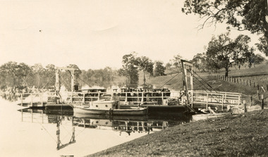
... ...Artificial Lake...This record is associated with the Heritage Listed sites of the Hume Dam and the Bethanga Bridge, and shows the environment during the process of construction and the creation of Lake Hume Bethanga Bethanga Bridge Hume Hume Dam Artificial Lake Lake Hume Hume Weir Flood Floodplain Boat Punt Weir Pier Dock Transport Transportation Reverse: 1997.3189 / 84 -19 -1 / This is the snap of the Punt. / Our only means of getting out / of Bethanga for the present / Until the bridge is completed / it is 2 miles above the junction / of the Mitta + Murray. ...This image shows the Punt (a kind of small boat) that took residents of Bethanga across the Murray River before the Bethanga Bridge was built. Bethanga Bridge was built between 1927 and 1930, and was made a necessity by the building of the Hume Dam. The Hume Dam, formerly known as the Hume Weir, was in construction between 1919 and 1936, which swelled the Murray River into the floodplain to the East of the dam permanently, creating Lake Hume, and isolating the residents of Bethanga and nearby towns, for whom the trip all the way around the new lake to another river crossing was a massive undertaking. The person who wrote on the back of this card instead chose to cross the river on a boat until the Bethanga Bridge became available. Interestingly, partially submerged trees can be seen in the lake in the background of this photograph, illustrating that the dam had already begun to fill the floodplain even before the bridge was built. This photograph shows the methods the residents of Bethanga used while the Bethanga Bridge was being built. This record is associated with the Heritage Listed sites of the Hume Dam and the Bethanga Bridge, and shows the environment during the process of construction and the creation of Lake HumeSepia rectangular photograph printed on matte photographic paperReverse: 1997.3189 / 84 -19 -1 / This is the snap of the Punt. / Our only means of getting out / of Bethanga for the present / Until the bridge is completed / it is 2 miles above the junction / of the Mitta + Murray. It is / 1/2 a mile wide + runs across / the Murray into NSW / Kodak Print / bethanga, bethanga bridge, hume, hume dam, artificial lake, lake hume, hume weir, flood, floodplain, boat, punt, weir, pier, dock, transport, transportation -
 Lakes Entrance Historical Society
Book, Bird, Eric and Lennon, Jane, Making an Entrance- The Story of the artificial entrance to the Gippsland Lakes, 1989
... Lakes'. Contains illustrations, Maps, Diagrams timed for the centenary of the opening of the artificial entrance at Lakes Entrance Victoria...Lakes'. Contains illustrations, Maps, Diagrams timed for the centenary of the opening of the artificial entrance at Lakes Entrance Victoria...Lakes'. Contains illustrations, Maps, Diagrams timed for the centenary of the opening of the artificial entrance at Lakes Entrance Victoria Exploration Coast Transport Civil Engineering Revised edition of an earlier publication 'The Entrance to the Gippsland Lakes'. ...Revised edition of an earlier publication 'The Entrance to the Gippsland Lakes'. Contains illustrations, Maps, Diagrams timed for the centenary of the opening of the artificial entrance at Lakes Entrance VictoriaRevised edition of an earlier publication 'The Entrance to the Gippsland Lakes'. Contains illustrations, Maps, Diagrams timed for the centenary of the opening of the artificial entrance at Lakes Entrance Victoriaexploration, coast, transport, civil engineering -
 Bendigo Historical Society Inc.
Photograph - FORTUNA COLLECTION; PHOTOGRAPH LAKE
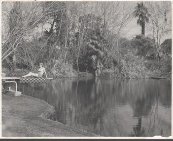
... Inscription in red pen on rear of photo reads 'An artificial lake in Survey Regiment 'Fortuna' Bend...Inscription in red pen on rear of photo reads 'An artificial lake in Survey Regiment 'Fortuna' Bend Photograph FORTUNA COLLECTION; PHOTOGRAPH LAKE ...Matt finish, black & white photograph, on cardboard back of same size. Photo depicts lake view with a woman sitting on diving board on left hand side of photo. Inscription in red pen on rear of photo reads 'An artificial lake in Survey Regiment 'Fortuna' Bendfortuna villa, photograph -
 Lakes Entrance Historical Society
Photograph, John Carpenter, 1880 c
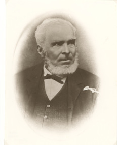
... John Carpenter was contractor for building artificial entrance Lakes Entrance Victoria...John Carpenter was contractor for building artificial entrance Lakes Entrance Victoria Celebrations Clubs Sepia toned photograph of John Carpenter showing a middle aged man with grey hair and trimmed beard wearing white shirt with narrow bow tie waistcoat and suitcoat Melbourne Victoria John Carpenter Photograph ...John Carpenter was contractor for building artificial entrance Lakes Entrance VictoriaSepia toned photograph of John Carpenter showing a middle aged man with grey hair and trimmed beard wearing white shirt with narrow bow tie waistcoat and suitcoat Melbourne Victoriacelebrations, clubs -
 Mortlake and District Historical Society
Queen Victoria's Oak Tree
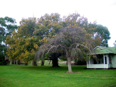
... This park was formerly the Botanic Gardens which were developed on what had been swamp land. An artificial lake was created there in 1988 as a Bi-Centenary project.The tree is located adjacent to the historic Montgomery Pavillion and was planted on the occasion of Her Majesty Queen Victoria's birthday on 24th May 1883. ...This park was formerly the Botanic Gardens which were developed on what had been swamp land. An artificial lake was created there in 1988 as a Bi-Centenary project.The tree is located adjacent to the historic Montgomery Pavillion and was planted on the occasion of Her Majesty Queen Victoria's birthday on 24th May 1883. ...This magnificent English oak tree is located at Tea Tree Lake park in Mortlake. This park was formerly the Botanic Gardens which were developed on what had been swamp land. An artificial lake was created there in 1988 as a Bi-Centenary project.The tree is located adjacent to the historic Montgomery Pavillion and was planted on the occasion of Her Majesty Queen Victoria's birthday on 24th May 1883. An outstanding tree, planted to commemorate a much-revered Queen in an historically-significant Botanic Gardens (now much altered). A very old oak tree planted 1883. queen victoria, mortlake, mortlake botanic gardens, tea tree lake, montgomery pavillion -
 Lakes Entrance Historical Society
Photograph - Tramway buffers North Arm Gippsland Lakes c1952
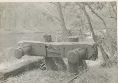
... Black and white photograph of the buffers beside the North Arm at the terminus of the tramway which carried rock from the Colquhoun quarry for forming the artificial entrance at Lakes Entrance Victoria.c1952...Waterways tramway Civil Engineering Black and white photograph of the buffers beside the North Arm at the terminus of the tramway which carried rock from the Colquhoun quarry for forming the artificial entrance at Lakes Entrance Victoria.c1952 Photograph Tramway buffers North Arm Gippsland Lakes c1952 ...Black and white photograph of the buffers beside the North Arm at the terminus of the tramway which carried rock from the Colquhoun quarry for forming the artificial entrance at Lakes Entrance Victoria.c1952 waterways, tramway, civil engineering -
 Lakes Entrance Historical Society
Photograph - New Works Lakes Entrance
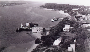
... Black and white photograph showing elevated view of Works buildings and cottages near artificial entrance to Gippsland Lakes Victoria...Boats and Boating Topography Settlement Historic Buildings Black and white photograph showing elevated view of Works buildings and cottages near artificial entrance to Gippsland Lakes Victoria Photograph New Works Lakes Entrance ...Black and white photograph showing elevated view of Works buildings and cottages near artificial entrance to Gippsland Lakes Victoria boats and boating, topography, settlement, historic buildings -
 Williamstown Botanic Gardens- Hobsons Bay City Council
Postcard – Williamstown Botanic Gardens, The Crown Studios, Sydney, c1900-1920
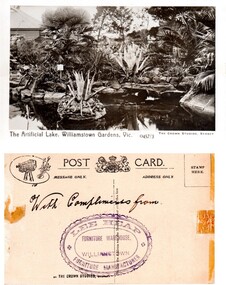
... Front: ‘The Artificial Lake, Williamstown Gardens. Vic.’ ‘0457/3’ ‘THE CROWN STUDIOS, SYDNEY’. ...Postcard Gardens Post-Card Williamstown-Botanic-Gardens Hobsons-Bay-City-Council Ornamental Lake Crown Studios Lee Heap Furniture Warehouse Front: ‘The Artificial Lake, Williamstown Gardens. Vic.’ ‘0457/3’ ‘THE CROWN STUDIOS, SYDNEY’. ...The lake was built in 1904, during the curatorship of Mr Thake. Lee Heap Furniture Warehouse of Williamstown used the postcards to advertise. The postcards are evidence of the interest the gardens held as a subject for postcard publishers. The text and images provide a snapshot into fashions, social interests and concerns of the time. The professionally produced images provide a pictorial history of Gardens including changing planting styles, various structures and features of the Gardens eg the aviary, cannons, the fountain, the second Curator’s Lodge and gates. The images offer an opportunity to compare garden vistas with the present day.Sepia image of the ornamental lake and part of the Curator’s Lodge in the background on the left side of card. The small island with a succulent is in the centre of the image with a similar plant on the right side of it. The water is edged with rocks. Reflections of the plantings and lodge can be seen.Front: ‘The Artificial Lake, Williamstown Gardens. Vic.’ ‘0457/3’ ‘THE CROWN STUDIOS, SYDNEY’. Reverse: Centre top ‘POST CARD’ with a logo in the middle of the words. Left top corner a drawing of an artist’s board and brushes with a camera in the centre. Left side ‘MESSAGE ONLY.’ Right side ‘ADDRESS ONLY.’ Top right corner inside a dotted rectangle ‘STAMP HERE’. Bottom on card ‘BY THE CROWN STUDIOS, SYNDEY.’ Under the vertical line down the middle line ‘Neither the Address not the Message must cross this line’. In ink ‘With Compliments from’. An oval stamp with scalloped rim ‘LEE HEAP FURNITURE MANUFACTURER’ inside inner oval ‘FURNITURE WAREHOUSE, / WILLIAMSTOWN’.postcard, gardens, post-card, williamstown-botanic-gardens, hobsons-bay-city-council, ornamental lake, crown studios, lee heap furniture warehouse -
 Lakes Entrance Historical Society
Postcard - North Arm bridge, Lakes Entrance Victoria c1898
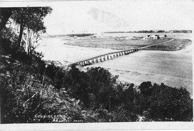
... Black and white postcard of wooden bridge across the North Arm, showing sand hummocks Cunninghame Arm, Club Hotel, and die back of melaleuca on mudflats, caused by salination of Gippsland Lakes after artificial entrance opened 1889. Vegetation on Kalimna Hill in foreground. ...Bridges Topography Township Cunninghame N Caire Black and white postcard of wooden bridge across the North Arm, showing sand hummocks Cunninghame Arm, Club Hotel, and die back of melaleuca on mudflats, caused by salination of Gippsland Lakes after artificial entrance opened 1889. Vegetation on Kalimna Hill in foreground. ...Black and white postcard of wooden bridge across the North Arm, showing sand hummocks Cunninghame Arm, Club Hotel, and die back of melaleuca on mudflats, caused by salination of Gippsland Lakes after artificial entrance opened 1889. Vegetation on Kalimna Hill in foreground. Steamer on Cunninghame Arm centre top of photo. Lakes Entrance VictoriaCunninghame N Cairebridges, topography, township -
 Lakes Entrance Historical Society
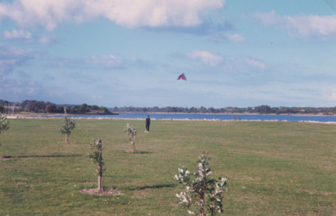
Photograph - Recreation Area Development Lakes Entrance, Lakes Post Newspaper, 1/04/1999 12:00:00 AM
... The artificially constructed knoll beside lake in the distance one person flying a kite from lawn Lakes Entrance Victoria. ...The artificially constructed knoll beside lake in the distance one person flying a kite from lawn Lakes Entrance Victoria. ...Colour photograph taken of the newly planted trees on the recreation area east of the footbridge. The artificially constructed knoll beside lake in the distance one person flying a kite from lawn Lakes Entrance Victoria. Also three colour photographs showing progress of recreation area east of the footbridge and instillation of rotunda. Small boy in foreground is Jarrod Elstob of Paynsville 04270.1, 04270.2, 04270.3 size 10 x 15 cmtownship, waterfront, recreation -
 Lakes Entrance Historical Society
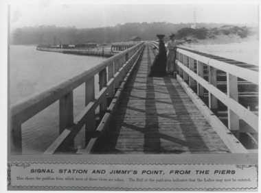
Photograph - Eastern pier at the entrance Lakes Entrance Victoria c1905, Caire, Nicholas John
... Black and white photograph of the decking and walkway platform atop the Eastern retaining wall of the artificial entrance to the Gippsland Lakes. The view shows the equipment used for unloading rock at the northern end of the pier, the site office, blacksmith shop, rocket shed and flagstaff. ...lakes may now be entered. Waterfront Government Waterways Fashion Beaches Black and white photograph of the decking and walkway platform atop the Eastern retaining wall of the artificial entrance to the Gippsland Lakes. ...Signal Station and Jimmy's Point from the piers. This shows the position from which most of these views are taken. The Ball at the yard-arm indicates that the lakes may now be entered.Black and white photograph of the decking and walkway platform atop the Eastern retaining wall of the artificial entrance to the Gippsland Lakes. The view shows the equipment used for unloading rock at the northern end of the pier, the site office, blacksmith shop, rocket shed and flagstaff. Two women on walkway in fashion of approximately 1900. Kalimna Heights and Jemmys Point in background. Lakes Entrance Victoriawaterfront, government, waterways, fashion, beaches -
 Lakes Entrance Historical Society
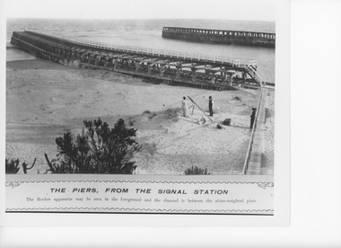
Photograph - The Piers , Lakes Entrance c1905, Caire, Nicholas John, c1905
... Black and white photograph of the overhead walkways on the piers of the artificial entrance to the Gippsland Lakes looking towards the open ocean. ...Waterfront Coast Safety Black and white photograph of the overhead walkways on the piers of the artificial entrance to the Gippsland Lakes looking towards the open ocean. ...The Piers, from the signal station. The rocket apparatus may be seen in the foreground and the channel is between the stone-weighted piers.Black and white photograph of the overhead walkways on the piers of the artificial entrance to the Gippsland Lakes looking towards the open ocean. One man and two women are standing near the rocket apparatus set up on a sandy knoll beside the timber path leading to the pier walkway. Lakes Entrance Victoriawaterfront, coast, safety -
 Lakes Entrance Historical Society
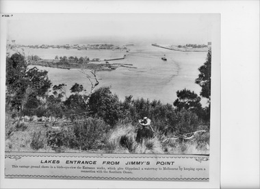
Photograph - The Entrance from Jemmy's Point Lakes Entrance c1905, Caire, Nicholas John
... Black and white photograph of a panorama of the artificial entrance to the Gippsland Lakes. The New Works village on the lake shore of the hummocks, the rock groynes at Bullock Island and a steamer in the main shipping channel of the lake. ...Lakes Entrance from Jimmy's Point. This vantage ground shows a birds eye view the Entrance works, which give Gippsland a waterway to Melbourne by keeping open a connection with the Southern Ocean. Waterfront Boats and Boating Township Waterways Islands Black and white photograph of a panorama of the artificial ...Lakes Entrance from Jimmy's Point. This vantage ground shows a birds eye view the Entrance works, which give Gippsland a waterway to Melbourne by keeping open a connection with the Southern Ocean.Black and white photograph of a panorama of the artificial entrance to the Gippsland Lakes. The New Works village on the lake shore of the hummocks, the rock groynes at Bullock Island and a steamer in the main shipping channel of the lake. Back view of a woman in hat and dark clothing seated amongst vegetation in foreground. Lakes Entrance Victoriawaterfront, boats and boating, township, waterways, islands -
Lakes Entrance Historical Society
Book, Bird, Eric and Lennon, Jane, The Entrance to the Gippsland Lakes, 1973
... A scientific and historical study of the artificial entrance to the entrance to the Gippsland Lakes, victoria. ...Exploration Transport Commerce Civil Engineering A scientific and historical study of the artificial entrance to the entrance to the Gippsland Lakes, victoria. ...A scientific and historical study of the artificial entrance to the entrance to the Gippsland Lakes, victoria. Includes references, illustrations, mapsexploration, transport, commerce, civil engineering -
Lakes Entrance Historical Society
Book, Bird E C F, The Geomorphology of the Gippsland Lakes Region, 1978
... A geomorphological study of the Gippsland lakes Region Victoria with reference to the effects of the artificial entrance, settlement, erosion and salinity on the changes to the configuration of the lakes, rivers, and coastline....Natural History Waterways Genealogy A geomorphological study of the Gippsland lakes Region Victoria with reference to the effects of the artificial entrance, settlement, erosion and salinity on the changes to the configuration of the lakes, rivers, and coastline. ...A geomorphological study of the Gippsland lakes Region Victoria with reference to the effects of the artificial entrance, settlement, erosion and salinity on the changes to the configuration of the lakes, rivers, and coastline.natural history, waterways, genealogy -
Lakes Entrance Historical Society
Book, Hewitt Geoff Bader Hans Dieter, Geometria, 2007
... Report on the geomagnetic archaeological survey of areas of prograded Ninety Mile Beach shore in East Gippsland Victoria, immediately to the East and West of the artificial entrance to the Gippsland Lakes....Waterways Topography Ships and Shipping Report on the geomagnetic archaeological survey of areas of prograded Ninety Mile Beach shore in East Gippsland Victoria, immediately to the East and West of the artificial entrance to the Gippsland Lakes. Geometria Book Hewitt Geoff Bader Hans Dieter ...Report on the geomagnetic archaeological survey of areas of prograded Ninety Mile Beach shore in East Gippsland Victoria, immediately to the East and West of the artificial entrance to the Gippsland Lakes.waterways, topography, ships and shipping -
Lakes Entrance Historical Society
Book, Fish Marie, Carpentertown A History of the New Works Cottages at Lakes Entrance by Marie Fish, 2008
... The story of the cottages at the New Works area at Lakes Entrance Victoria, their relationship to the early fishing industry and the construction of the artificial entrance from Bass Strait to the Gippsland Lakes, and the past and recent residents....Civil Engineering Land Settlement The story of the cottages at the New Works area at Lakes Entrance Victoria, their relationship to the early fishing industry and the construction of the artificial entrance from Bass Strait to the Gippsland Lakes, and the past and recent residents. ...The story of the cottages at the New Works area at Lakes Entrance Victoria, their relationship to the early fishing industry and the construction of the artificial entrance from Bass Strait to the Gippsland Lakes, and the past and recent residents.civil engineering, land settlement -
Lakes Entrance Historical Society
Book, LERHS, Background to Entrance Construction, 1989|2013
... Containing background information about the planning construction and opening of the artificial entrance from the ocean to the Gippsland Lakes Victoria...Waterways Civil Engineering Topography Containing background information about the planning construction and opening of the artificial entrance from the ocean to the Gippsland Lakes Victoria Background to Entrance Construction Book LERHS ...Containing background information about the planning construction and opening of the artificial entrance from the ocean to the Gippsland Lakes Victoriawaterways, civil engineering, topography -
Lakes Entrance Historical Society
Book - Centenary of the opening of the artificial entrance memories, LERHS, Festivals, 1995
... Newspaper clippings giving report of two festivals the centenary of the opening of the artificial entrance memories of Healey on the lakes and the centenary of change of name from Colquhoun to Lakes Entrance Victoria...Celebrations Newspaper clippings giving report of two festivals the centenary of the opening of the artificial entrance memories of Healey on the lakes and the centenary of change of name from Colquhoun to Lakes Entrance Victoria Festivals Book Centenary of the opening of the artificial entrance memories LERHS ...Newspaper clippings giving report of two festivals the centenary of the opening of the artificial entrance memories of Healey on the lakes and the centenary of change of name from Colquhoun to Lakes Entrance Victoriacelebrations -
 Lakes Entrance Historical Society
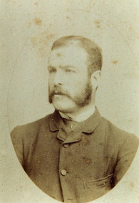
Photograph - George Carpenter c1900
... Black and white photograph of George Carpenter, eldest son of John Carpenter contractor for construction of artificial entrance to the Gippsland Lakes....Genealogy Black and white photograph of George Carpenter, eldest son of John Carpenter contractor for construction of artificial entrance to the Gippsland Lakes. Photograph George Carpenter c1900 ...Black and white photograph of George Carpenter, eldest son of John Carpenter contractor for construction of artificial entrance to the Gippsland Lakes.genealogy -
 Lakes Entrance Historical Society
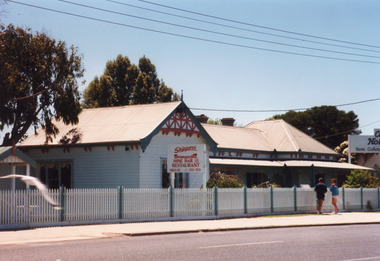
Photograph - Skippers Restaurant Esplanade Lakes Entrance Victoria1999c
... artificial entrance. On this site home and office of Carpenter's Caravan Park. Architecture Township Restaurant Colour photograph of Skippers Restaurant, Esplanade. It shows a weatherboard building, centre roof connects eastern hipped roof and western gable which is half timbered in Tudor style. Decorative corbels support eaves. Wrought iron lacework and brackets under veranda roof. Lakes ...Original home of George Carpenter, son of John Carpenter, first contractor for the artificial entrance. On this site home and office of Carpenter's Caravan Park.Colour photograph of Skippers Restaurant, Esplanade. It shows a weatherboard building, centre roof connects eastern hipped roof and western gable which is half timbered in Tudor style. Decorative corbels support eaves. Wrought iron lacework and brackets under veranda roof. Lakes Entrance Victoriaarchitecture, township, restaurant -
 Lakes Entrance Historical Society
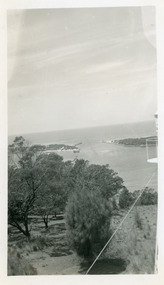
Photograph - The Entrance Lakes Entrance Victoria c1950
... Black and white photograph of the artificial entrance from Bass Strait to the Gippsland Lakes, taken from the lookout tower on Jemmy's Point. ...Islands Waterways Black and white photograph of the artificial entrance from Bass Strait to the Gippsland Lakes, taken from the lookout tower on Jemmy's Point. ...Black and white photograph of the artificial entrance from Bass Strait to the Gippsland Lakes, taken from the lookout tower on Jemmy's Point. In foreground is the natural vegetation of Jemmy's Point and a glimpse of the light beacon. Lakes Entrance Victoriaislands, waterways -
 Lakes Entrance Historical Society
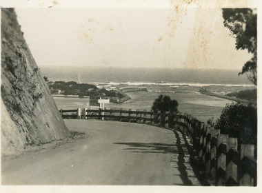
Postcard - Princes Highway Kalimna Hill. Lakes Entrance Victoria c1940, Bulmer H.D
... The artificial entrance from Bass Strait to Lakes system is in view. ...The artificial entrance from Bass Strait to Lakes system is in view. ...Black and white small format postcard showing a bend in the Princes Highway on the Kalimna Hill. The road runs between the steep road cutting and post and rail guard fence. The artificial entrance from Bass Strait to Lakes system is in view. Lakes Entrance Victoriawaterways, islands -
 Lakes Entrance Historical Society
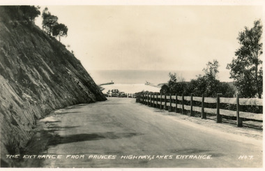
Postcard - Princes Highway at Kalimna Hill Lakes Entrance c1940, Valentine Series
... In the distance is the artificial entrance to the Gippsland Lakes. Lakes Entrance Victoria...Roads and Streets Fences The entrance from Princes Highway, Lakes Entrance Black and white small format postcard of the Princes Highway at Kalimna Hill The road winds between the steep road cutting and a post & rail guard fence. In the distance is the artificial ...Black and white small format postcard of the Princes Highway at Kalimna Hill The road winds between the steep road cutting and a post & rail guard fence. In the distance is the artificial entrance to the Gippsland Lakes. Lakes Entrance VictoriaThe entrance from Princes Highway, Lakes Entranceroads and streets, fences -
 Lakes Entrance Historical Society
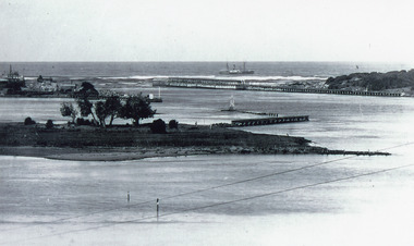
Photograph - Bullock Island and The Entrance Lakes Entrance Victoria c1915
... artificial entrance from Bass Strait. It shows the western end of Bullock Island, some natural vegetation, jetty and timber groynes and trading vessel standing outside entrance. Lakes...artificial entrance from Bass Strait. It shows the western end of Bullock Island, some natural vegetation, jetty and timber groynes and trading vessel standing outside entrance. Lakes ...On back of original 'To Rit with love from Arthur' (Arthur Seagrove - Head Teacher, Johnsonville Primary School - 1920)Black and white photograph of Bullock Island and the artificial entrance from Bass Strait. It shows the western end of Bullock Island, some natural vegetation, jetty and timber groynes and trading vessel standing outside entrance. Lakes Entrance Victoriawaterways, islands, topography -
 Lakes Entrance Historical Society
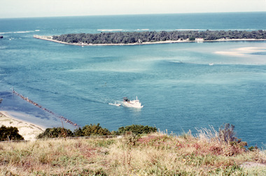
Photograph - The Entrance from Jemmys Point Lakes Entrance c1990, Fraser, Ian
... It shows a fishing boat with scallop dredge moving up the lake opposite the artificial entrance, grassy edge of Jemmy's Point in foreground above highway guard fence, rock groyne at entry to North Arm, sandy shallows at entry to Hopetoun Channel, scrub covered hummocks of south shore and Bass Strait in distance. ...It shows a fishing boat with scallop dredge moving up the lake opposite the artificial entrance, grassy edge of Jemmy's Point in foreground above highway guard fence, rock groyne at entry to North Arm, sandy shallows at entry to Hopetoun Channel, scrub covered hummocks of south shore and Bass Strait in distance. ...Colour photograph of the lake. It shows a fishing boat with scallop dredge moving up the lake opposite the artificial entrance, grassy edge of Jemmy's Point in foreground above highway guard fence, rock groyne at entry to North Arm, sandy shallows at entry to Hopetoun Channel, scrub covered hummocks of south shore and Bass Strait in distance. Lakes Entrance Victoriaislands, waterways, topography -
 Kew Historical Society Inc
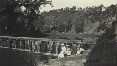
Photograph, Richardson Family at Dight's Falls, 1920
... artificial weir built on a natural rock bar across the Yarra. The weir was built in the 1840s to provide water to the ‘Ceres’ flour-mill, one of the first in Victoria. The falls were later to become known as Dight’s Falls after the owners of the mill. Later, a pumping station was built on the Kew side of the river, which pumped water uphill to a reservoir in Walmer Street that provided water to the Melbourne Botanical Gardens and to Albert Park Lake. ...artificial weir built on a natural rock bar across the Yarra. The weir was built in the 1840s to provide water to the ‘Ceres’ flour-mill, one of the first in Victoria. The falls were later to become known as Dight’s Falls after the owners of the mill. Later, a pumping station was built on the Kew side of the river, which pumped water uphill to a reservoir in Walmer Street that provided water to the Melbourne Botanical Gardens and to Albert Park Lake. ...Dight’s Falls in Studley Park is an artificial weir built on a natural rock bar across the Yarra. The weir was built in the 1840s to provide water to the ‘Ceres’ flour-mill, one of the first in Victoria. The falls were later to become known as Dight’s Falls after the owners of the mill. Later, a pumping station was built on the Kew side of the river, which pumped water uphill to a reservoir in Walmer Street that provided water to the Melbourne Botanical Gardens and to Albert Park Lake. The area around Dight’s Falls was and is frequently used for recreational activities.This photograph forms part of the collection assembled by the historian Dorothy Rogers, that was donated to the Kew Historical Society by her son John Rogers in 2015. The manuscripts, photographs, maps, and documents were sourced by her from both family and local collections or produced as references for her print publications. Many were directly used by Rogers in writing ‘Lovely Old Homes of Kew’ (1961) and 'A History of Kew' (1973), or the numerous articles on local history that she produced for suburban newspapers. Most of the photographs in the collection include detailed annotations in her hand. The Rogers Collection provides a comprehensive insight into the working habits of a historian in the 1960s and 1970s. Together it forms the largest privately-donated collection within the archives of the Kew Historical Society.Black and white photograph of the Richardson family seated on the Kew side of Dight's Falls in 1920. One of the girls in the photograph was to become the Melbourne historian Dorothy (Richardson) Rogers.Annotation on reverse: "Mrs D. Rogers, 29 Park Crst Kew. Dights Falls 1920"dight's falls - kew (vic) - fairfield (vic), sport and recreation - kew (vic), dorothy rogers -
 Kew Historical Society Inc
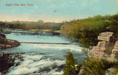
Postcard - Dight's Falls, River Yarra, c.1911
... artificial weir built on a natural rock bar across the Yarra. The weir was built in the 1840s to provide water to the ‘Ceres’ flour-mill, one of the first in Victoria. The falls were later to become known as Dight’s Falls after the owners of the mill. Later, a pumping station was built on the Kew side of the river, which pumped water uphill to a reservoir in Walmer Street that provided water to the Melbourne Botanical Gardens and to Albert Park Lake. ...artificial weir built on a natural rock bar across the Yarra. The weir was built in the 1840s to provide water to the ‘Ceres’ flour-mill, one of the first in Victoria. The falls were later to become known as Dight’s Falls after the owners of the mill. Later, a pumping station was built on the Kew side of the river, which pumped water uphill to a reservoir in Walmer Street that provided water to the Melbourne Botanical Gardens and to Albert Park Lake. ...Dight’s Falls in Studley Park is an artificial weir built on a natural rock bar across the Yarra. The weir was built in the 1840s to provide water to the ‘Ceres’ flour-mill, one of the first in Victoria. The falls were later to become known as Dight’s Falls after the owners of the mill. Later, a pumping station was built on the Kew side of the river, which pumped water uphill to a reservoir in Walmer Street that provided water to the Melbourne Botanical Gardens and to Albert Park Lake. The area around Dight’s Falls was and is frequently used for recreational activities.Dated postcard allowing one to analyse the form of the Falls in 1911Colour postcard, of Dight's Falls on the River Yarra between Kew and Fairfield. The photograph is taken looking upstream towards the Falls from the Kew side, from the embankment in the vicinity of the Pumping Station. Obverse: "Dight's falls, Kew" Reverse: "Printed in Great Britain Writing in ink on Reverse: "31/3/1911 / To dear Nell with best wishes for a happy birthday from your old friend Eve / [Addressed to] "Mrs N Dunn, Prahran" Franked Victorian 1d stamp on Reverse top rightdight's falls, dight's falls - kew (vic) - fairfield (vic) -
 Kew Historical Society Inc
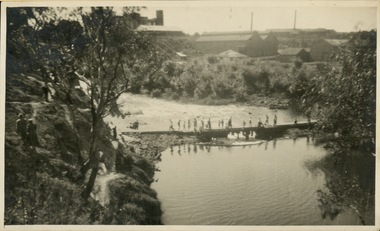
Photograph - Crossing Dights' Falls on the Yarra by foot
... artificial weir built on a natural rock bar across the Yarra. The weir was built in the 1840s to provide water to the ‘Ceres’ flour-mill, one of the first in Victoria. The falls were later to become known as Dight’s Falls after the owners of the mill. Later, a pumping station was built on the Kew side of the river, which pumped water uphill to a reservoir in Walmer Street that provided water to the Melbourne Botanical Gardens and to Albert Park Lake. ...artificial weir built on a natural rock bar across the Yarra. The weir was built in the 1840s to provide water to the ‘Ceres’ flour-mill, one of the first in Victoria. The falls were later to become known as Dight’s Falls after the owners of the mill. Later, a pumping station was built on the Kew side of the river, which pumped water uphill to a reservoir in Walmer Street that provided water to the Melbourne Botanical Gardens and to Albert Park Lake. ...Dight’s Falls in Studley Park is an artificial weir built on a natural rock bar across the Yarra. The weir was built in the 1840s to provide water to the ‘Ceres’ flour-mill, one of the first in Victoria. The falls were later to become known as Dight’s Falls after the owners of the mill. Later, a pumping station was built on the Kew side of the river, which pumped water uphill to a reservoir in Walmer Street that provided water to the Melbourne Botanical Gardens and to Albert Park Lake. The area around Dight’s Falls was and is frequently used for recreational activities.Rare original print photograph of people walking across Dight's Falls when the river flow was low. View west towards Abbotsford. Photograph taken from Kew side of river above the Falls.Reverse: "M Holmes"dight's falls, river yarra -- kew - abbotsford -
 Kew Historical Society Inc
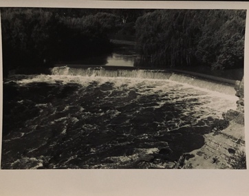
Photograph - Dight's Falls, 1920s
... artificial weir built on a natural rock bar across the Yarra. The weir was built in the 1840s to provide water to the ‘Ceres’ flour-mill, one of the first in Victoria. The falls were later to become known as Dight’s Falls after the owners of the mill. Later, a pumping station was built on the Kew side of the river, which pumped water uphill to a reservoir in Walmer Street that provided water to the Melbourne Botanical Gardens and to Albert Park Lake. ...artificial weir built on a natural rock bar across the Yarra. The weir was built in the 1840s to provide water to the ‘Ceres’ flour-mill, one of the first in Victoria. The falls were later to become known as Dight’s Falls after the owners of the mill. Later, a pumping station was built on the Kew side of the river, which pumped water uphill to a reservoir in Walmer Street that provided water to the Melbourne Botanical Gardens and to Albert Park Lake. ...Dight’s Falls in Studley Park is an artificial weir built on a natural rock bar across the Yarra. The weir was built in the 1840s to provide water to the ‘Ceres’ flour-mill, one of the first in Victoria. The falls were later to become known as Dight’s Falls after the owners of the mill. Later, a pumping station was built on the Kew side of the river, which pumped water uphill to a reservoir in Walmer Street that provided water to the Melbourne Botanical Gardens and to Albert Park Lake. The area around Dight’s Falls was and is frequently used for recreational activities.One of a series of photographs, probably taken by Henry Christian of the Yarra River in Kew. An item from an outstanding and diverse photographic collection, assembled by members of the Christian and Washfold families of Kew.River Yarra at Dight’s Falls, Kew/Fairfield photographed from Kew bank.dight's falls, river yarra, christian-washfold collection
