Showing 700 items matching assessment
-
 Eltham District Historical Society Inc
Ledger, Eltham Road District. Assessment for the Year ending Oct. 14th, 1863, 1862c
The Eltham Roads Board was established in 1856. This is a unique significant record of early settlers in the Shire of Eltham. One of 6 early rate books. This is among the oldest items in the EDHS collection. An article in the Eltham and Whittlesea Shires Advertiser Friday 21 Nov 1941 Page 5 titled: District's Early History states: "The first rate book which is still in existence at the Shire Office is for the year ending October 14, 1858 and is probably the best record possible to indicate the development of the district. At the time properties were rated as follows: Cultivated land. 6d. per acre; pasture land, 1d. per acre: estimated annual value of buildings, etc., 6d in the (pound). The total amount of rate recorded for the year was (pounds)153/14/8. Properties were described as being situated at Lower Plenty, Yarra Yarra, Eltham, Lower Eltham, Kangaroo Ground, Yarra Flats, Diamond Creek and the Yarra."Ledger with printed columns: Number, Name of Occupier, Description, Where situated, Cultivated land, Pasture land, Estimated annual value of buildings, Rate, Remarks, Arrears collected, excused, unoccupied, uncollected and amount actually collected. Ledger filled out by hand with 181 entries (not alphabetically arranged) and summary section. A number of blank pages are included. Inside cover includes pasted printed note: RATE OF ASSESSMENT AS FOLLOWS: Cultivated land 6d per acre Pasture land 1/2d per acre Unalienated Pasture Land 1/28 per Acre Estimated Annual Value of Buildings, &c., 6d. in the Pound eltham roads board, rate book, rate payers, transaction, pioneers, settlers, 1863, assessment ledger, eltham road district, public records office victoria (prov), rate books, shire of eltham archives -
 Eltham District Historical Society Inc
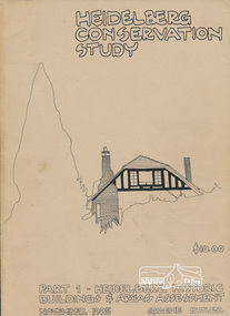
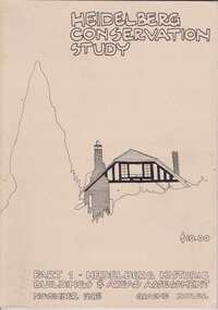
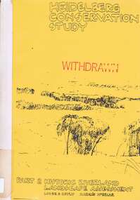
Book, Graem Butler, Heidelberg Conservation Study, Part 1 Heidelberg Historic Buildings and Areas Assessment by Graeme Butler, November 1985
Historic Buildings and Areas Assessment by Graeme Butler. Part 1 of award winning study carried out in 1982 in collaboration with a community advisory committee to Heidelberg City Council. Pioneering identification of a broad range of heritage assets varying from buildings, gravestones, farm structures, landscape areas, mileposts, divided street construction, in a time when buildings only were assessed in municipal studies.2 v. : ill., maps ; 29 cm.significant buildings heidelberg victoria, history development of heidelberg victoria, man-made landscape heidelberg victoria, significant precincts heidelberg victoria, conservation study, graeme butler -
 Kew Historical Society Inc
Document, Kew Historical Society Collection : Preservation Needs Assessment, 2021
Following a Significance Assessment, in 2020, Kew Historical Society received a Community Heritage Grant from the National Library of Australia for a Preservation Needs Assessment, prepared by Grimwade Conservation Services (GCS). The purpose of the assessment was to consider the physical condition of the collection, the suitability of the current housing and storage facilities and to make recommendations for the development of a conservation program.Illustrated 87-page Final Report by Vanessa Kowalski (Grimwade Conservation Services), including - Executive Summary / p5. Key recommendations / p7. Policies and Procedures / p9. Collection / p11. Building (Repository Structure) / p25. Environment / p33. Storage / p41. Display/Exhibitions / p54. Housekeeping / p58. Visitor Impact / p51. Disaster Preparedness / p63. Training Needs/Skills Assessment / p65. Action Plan / p67. Authorship / p71. References / p73. Appendices / p75. non-fictionFollowing a Significance Assessment, in 2020, Kew Historical Society received a Community Heritage Grant from the National Library of Australia for a Preservation Needs Assessment, prepared by Grimwade Conservation Services (GCS). The purpose of the assessment was to consider the physical condition of the collection, the suitability of the current housing and storage facilities and to make recommendations for the development of a conservation program.preservation needs assessments, kew historical society -- collections, kew historical society - conservation, community heritage grants -
 Eltham District Historical Society Inc
Ledger, Eltham Road District. Assessment for the Year ending Oct. 14th, 1858, 1857c
The Eltham Roads Board was established in 1856. This is a unique significant record of early settlers in the Shire of Eltham. One of 6 early rate books. This is among the oldest items in the EDHS collection. An article in the Eltham and Whittlesea Shires Advertiser Friday 21 Nov 1941 Page 5 titled: District's Early History states: "The first rate book which is still in existence at the Shire Office is for the year ending October 14, 1858 and is probably the best record possible to indicate the development of the district. At the time properties were rated as follows: Cultivated land. 6d. per acre; pasture land, 1d. per acre: estimated annual value of buildings, etc., 6d in the (pound). The total amount of rate recorded for the year was (pounds)153/14/8. Properties were described as being situated at Lower Plenty, Yarra Yarra, Eltham, Lower Eltham, Kangaroo Ground, Yarra Flats, Diamond Creek and the Yarra."Ledger with printed columns: Number, Name of Occupier, Description, Where situated, Cultivated land, Pasture land, Estimated annual value of buildings, Rate, Remarks. Ledger filled out by hand with 152 entries (not alphabetically arranged). A number of blank pages are included. Copy re-bound in green hard leather look card by Arnall & Jackson Pty Ltd Brunswick, 1968 Inside cover includes a compliments slip taped to the cover from Arnall & Jackson Pty Ltd. with handwritten inscription: "Ian, I hope the hysterical society doesn't get historical about this". Organised 1968 I. Maynard Inside cover includes pasted printed note: RATE OF ASSESSMENT AS FOLLOWS: Cultivated land 6d per acre Pasture land 1 per acre Estimated Annual Value of Buildings, &c., 6d. in the Pound eltham roads board, rate book, rate payers, transaction, pioneers, settlers, 1858, assessment ledger, eltham road district, public records office victoria (prov), rate books, shire of eltham archives -
 Melbourne Tram Museum
Document - Report, Heritage Victoria, "Recommendation of the Executive Director and assessment of cultural heritage significance - Brunswick West Tramway Substation", Nov. 2019
Digital copy of a 50 page report - "Recommendation of the Executive Director and assessment of cultural heritage significance - Brunswick West Tramway Substation" at 196a Dawson St Brunswick West. Report prepared November 2019. Details the history and context of the location relevant to the development of the West Coburg route, the equipment contained within the building, includes all moveable objects within the building including documents. Has a detailed statement of cultural significance, proposed permit policy. The history includes details of the electrification of the Melbourne's tramways, the mercury arc equipment, its operation, architecture. Report includes photographs of the interior of the building.trams, tramways, substation, west brunswick electric tramway, mercury arc, heritage victoria, significance, dawson st, transformer, power supply, electrical engineering, rotary converters -
 Ballarat Tramway Museum
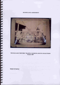
Document - Report, Stella Barber, "Significance Assessment - The Ballarat Historic Tramway Museum and its Collections Oct. 2007", Jan. 2008
Yields information about the BTM collection as at 2007 and has a strong association with the work of Stella Barber.Seventy One page report, within plastic front cover and black card rear cover, wire bound, titled "Significance Assessment - The Ballarat Historic Tramway Museum and its Collections Oct. 2007". Written by Stella Barber of SMB Wordsmith for the BTM with a grant from Heritage Victoria. Completed Oct. 2007. Examines the significance overall of the BTM collection, has many illustrations of objects within the collection and looks at their significance from a Museum point of view. Illustration in black and white and colour. Document held on CD as well. Page 71 has notes on Stella Barber with a photograph. Copy printed by BTM 1/2008. trams, tramways, btm, significance, collection management, collection -
 Melbourne Tram Museum
Document - Report, Heritage Victoria, "Recommendation of the Executive Director and assessment of cultural heritage significance - Malvern Tram Depot - Amendment - 20/2/2020", Jan. 2020
Digital copy of a 60 page report - ""Recommendation of the Executive Director and assessment of cultural heritage significance - Malvern Tram Depot - Amendment - 20/2/2020" Details the history and context of the location relevant to the development of the PMTT and MMTB systems route, the equipment contained within the building, includes all moveable objects within the building including documents. Has a detailed statement of cultural significance, proposed permit policy. The history includes details of the electrification of the Melbourne's tramways, the rotary converter equipment, its operation, architecture. Report includes photographs of the interior of the building. The last amendment was to include the items with the former Rotary Converter sub-station.trams, tramways, substation, malvern depot, rotary converters, heritage victoria, significance, coldblo road, transformer, power supply, electrical engineering, pmtt, mmtb -
 Ringwood and District Historical Society
Book, Bryce Raworth, Heritage Impact Assessment - 1 Bedford Road, Ringwood, Victoria. Application for permit - Proposed Redevelopment - July 2021, 2021
A4 size wire-bound book compiled by Bryce RaworthINTRODUCTION: This heritage impact assessment (HIS) was prepared at the request of the City of Maroondah, the owner of the subject property at 1 Bedford Street (sic), Ringwood. It relates to a proposal to demolish the existing shop on the site and construct a multi-storey car park incorporating a commercial tenancy at the lower levels. It reviews the significance of the existing building on the site and the contribution it makes to the surrounding streetscapes, then comments on the heritage impacts of the proposed demolition in the context of the significance of the place and broader considerations. This office has previously provided an Historical Overview of the subject site (June 2020) and this assessment draws upon that previous research and analysis. The report has been prepared by Guy Murphy and Bryce Raworth. CONCLUSION: The proposed demolition of the former Blood Brothers Store at 1 Bedford Street (sic), Ringwood and the construction of a multi-storey car park on the enlarged site will result in the loss of some significance to the Heritage Overlay. The degree of loss is moderated by the partial intactness of the store, its modest character and the loss of its original setting, as well the proposal to implement a heritage interpretation strategy for the site. When considered in the context of the broader range of urban planning considerations and broader net community benefit, the proposed development is supported with respect to heritage impacts. -
Ballarat Tramway Museum
Document - Report, Connell Wagner, "Ballarat Heritage Tram Route Concept Engineering Assessment", 22/03/2002 12:00:00 AM
Forty Eight sheet A4 size document, unbound, printed mainly double sided "Ballarat Heritage Tram Route Concept Engineering Assessment". Produced by Connell Wagner for Booz Allen Hamilton as part of the project study for the return of trams to the central part of the City of Ballarat. Document, dated 1/3/2002. See Reg, Item 2273 for a bound draft version of this document. Has an introduction, looks at the concept for each section of the route with a photograph showing possible route, features, looks at passing loop locations, tram stop locations, substations, potential depot sites, concept construction costs and has maps of preferred route and alternative routes, depot options, concept construction costs, typical track cross sections and costing detail. Has an index.trams, tramways, ballarat city tramway, ballarat revival, civil engineering, depot -
Ballarat Tramway Museum
Document - Report, Connell Wagner, "Ballarat Heritage Tram Route Concept Engineering Assessment", Mar. 2002
Seventy Seven page A4 size document, bound with clear plastic cover, black coloured card back cover using a black comb binder, titled "Ballarat Heritage Tram Route Concept Engineering Assessment". Produced by Connell Wagner for Booz Allen Hamilton as part of the project study for the return of trams to the central part of the City of Ballarat. Draft Document, dated 1/3/2002. Has an introduction, looks at the concept for each section of the route with a photograph showing possible route, features, looks at passing loop locations, tram stop locations, substations, potential depot sites, concept construction costs and has maps of preferred route and alternative routes, depot options. Note folio page 40 assumes the track in the pavement at Armstrong St was the original track - not the replica crossing to the Phoenix foundry. Has an index.trams, tramways, ballarat city tramway, ballarat revival, civil engineering, depot -
 Federation University Historical Collection
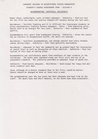
Document - Document - Assessment Form, VIOSH - Ballarat College of Advanced Education; Graduate Diploma in Occupational Hazard Management, Student's Course Assessment Form
Victorian Institute of Occupational Safety and Health (VIOSH) Australia is the Asia-Pacific centre for teaching and research in occupational health and safety (OHS) and is known as one of Australia's leaders on the field. VIOSH has a global reputation for its innovative approach within the field of OHS management. VIOSH had its first intake of students in 1979. At that time the Institution was known as the Ballarat College of Advanced Education. In 1990 it became known as Ballarat University College, then in 1994 as University of Ballarat. It was 2014 that it became Federation University. VIOSH Australia students are safety managers, senior advisors and experienced OHS professionals. They come from all over Australia and industry. Students are taught active research and enquiry; rather than textbook learning and a one-size fits all approach. VIOSH accepts people into the Graduate Diploma of Occupational Hazard Management who have no undergraduate degree - on the basis of extensive work experience and knowledge. At the completion of Session 4 and Session 2, students were asked to complete an assessment form covering various aspects of the course and accommodation. For each course unit they were to grade the statements according to the scale - 5 Agree Strongly; 4 Agree; 3 No feeling one way or the other; 2 Disagree; 1 Strongly Disagree Comments on Accommodation, Cafeteria, Residences, Course Administration - Timetabling, Communication and Co-ordination plus Other. Other allowed for students to choose to comment on what they thought was important - e.g.guidance in dissertations.Ten A4 pages, typed. Two in grid formviosh, victorian institute of occupational safety and health, student's course assessment, graduate diploma in occupational hazard management, ballarat college of advanced education, grade statements according to scale, residences, course administration, communications, guidance in dissertations -
 Kew Historical Society Inc
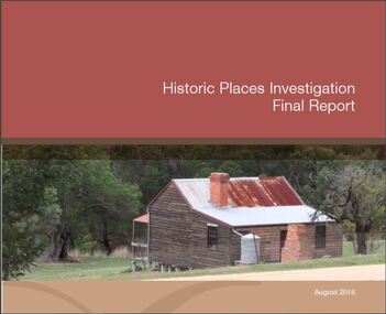
Book, Victorian Environmental Assessment Council, Historic Places Investigation: Final report, 2016
Victorian Assessment of historic sitesEast Melbourne, Victoria : VEAC, 2016 ©2016 viii, 50 pages : colour illustrations ; 30 cm non-fictionVictorian Assessment of historic siteshistoric buildings -- victoria., historic sites -- victoria., public lands -- victoria. -
 Victorian Aboriginal Corporation for Languages
Book with CD-ROM, Senior Secondary Assessment Board of South Australia, Australia's Indigenous languages, 1996
The book shows that Australia's languages are rich, living languages that are relevant to all Australians. You can share the pride that Indigenous people have in their language by reading their accounts of what their language means to them and by learning about how Australian Indigenous languages are structured and used.Maps, colour illustrations, colour photographs, word lists, sheet music, CD-ROMlanguage and culture, bilingual education, linguistics, language and technology, yorta yorta, ganai -
Victorian Aboriginal Corporation for Languages
Book, Senior Secondary Assessment Board of South Australia, Australia's Indigenous languages in practice, 1996
Based on the Australian Indigenous Languages Framework.b&w illustrations, tables, word lists, sample programs and examination paperskaurna, pitjantjatjara, yankunytjatjara, antikirinya, yolgnu, pilbara, language and culture, bilingual education, linguistics, language and technology, teaching programs, -
Victorian Aboriginal Corporation for Languages
Book, Victorian Curriculum and Assessment Authority, Victorian essential learning standards, 2005
curriculum development, secondary school education, primary school education -
Victorian Aboriginal Corporation for Languages
Book, Victorian Curriculum and Assessment Authority, Victorian essential learning standards : overview, 2005
curriculum development, secondary school education, primary school education -
 Victorian Aboriginal Corporation for Languages
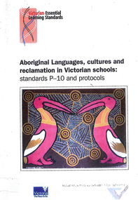
Book, Victorian Curriculum and Assessment Authority, Aboriginal languages, cultures and reclamation in Victorian schools : standards P-10 and protocols, 2009
maps, diagramseducation, language revival, bilingual education -
Federation University Historical Collection
Booklet, Victorian Curriculum and Assessment Authority, Indigenous Languages of Victoria: Revival and Reclamation, 2004
Purple soft covered Victorian Certificate of Education Study Design. Includes a brief summary of Indigenous languages of Victoria.indigenous languages, aboriginal, aborigines, kulin, kulin languages, education, curriculum, victorian certificate of education study design -
 Camberwell Historical Society
Booklet (Item) - Report, Phil Honeywood, Historic Places Investigation Final Report, 2016
melbourne, victoria, council -
 Port Melbourne Historical & Preservation Society
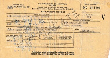
Document - Triplicate copy of Commonwealth of Australia Employees Income Tax Assessment record, Commonwealth of Australia, 1948
1948 Tax Assessment certificate belonged to donor's father, Percy MAY . It was filled in by Shipowners Waterside Pay Office , Commonwealth of Australia , Victoria . The Assessment was pounds 18 shillings for a Gross salary of 604 pounds & 19 shillings.Buff coloured, triplicate copy of Employees Record of Tax Assessment 1948.On reverse mathematical calculations in pounds, shillings & pence.percy allan may, income tax, shipowners' waterside pay office -
 Greensborough Historical Society
Book, Heidelberg Conservation Study: Part 1 Historic Buildings and Areas Assessment, 1985_
Report prepared by Graeme Butler on behalf of City of Heidelberg and Heidelberg Heritage Advisory Committee. Area covered is from Eaglemont in the south to Macleod in the north.This study identifies neighbourhood character, documents past development and the capacity of the environment for future development.Part one of set of three books. Paperback, 189 pages, Illus., maps. 2 copies.Stamps: Yarra Plenty Regional Library Service, and, Withdrawnheidelberg, macleod, heidelberg heritage advisory committee, graeme butler, plenty river, eaglemont -
 Greensborough Historical Society
Book, Heidelberg Conservation Study: Part 2: Historic Riverland Landscape Assessment. Revised 1987, 1987_
Report prepared by Loder and Bayly and Marilyn McBriar on behalf of City of Heidelberg and Heidelberg Heritage Advisory Committee. Area covered is from Darebin Parklands in the south to Plenty River at Yallambie in the north. Revised 1987.This study identifies neighbourhood character, documents past development and the capacity of the environment for future development with particular emphasis on the river precincts - Plenty River, Yarra River and Darebin Creek.Part three of set of three books. Paperback, 333 pages, Illus., maps. 2 copies.Stamps: Yarra Plenty Regional Library Service, and, Withdrawnheidelberg, macleod, heidelberg heritage advisory committee, marilyn mcbriar, plenty river, yarra river, darebin creek -
Phillip Island and District Historical Society Inc.
Book, Significance assessment : Phillip Island & District Historical Society Inc., Cleeland Bequest library and art collection, 2009
-
Phillip Island and District Historical Society Inc.
Book, WOODHOUSE, Fay, Significance assessment : Phillip Island & District Historical Society, Museum, 2011
-
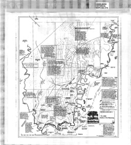 Greensborough Historical Society
Map, Heidelberg: Historic River Landscape Assessment, Historical Maps. Map A To 1838. Country of the Wawarang, 1985c
Geographical area of around 35 sq. kilometres marked with physical features such as major roads, rivers, vegetation and properties, with contemporary notes on landowners, descriptions and comments on the land and its development. Bounded by Shire of Diamond Valley to the North, Darebin Creek to the West and Plenty River to the East.Black an white sketch map on white paperheidelberg, heidelberg - maps -
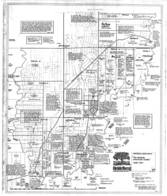 Greensborough Historical Society
Map, Heidelberg: Historic River Landscape Assessment. Historical Maps. Map B 1838-1851, "The Distinctly aristocratic locality", 1985c
Geographical area of around 35 sq. kilometres marked with physical features such as major roads, rivers, vegetation and properties, with contemporary notes on landowners, descriptions and comments on the land and its development. Bounded by Shire of Diamond Valley to the North, Darebin Creek to the West and Plenty River to the EastBlack and white sketch map on white paperheidelberg, heidelberg - maps -
 Greensborough Historical Society
Map, Heidelberg. Historic River Landscape Assessment. Historical maps: Map C 1851-1863. "The Garden of the colony", 1985c
Geographical area of around 35 sq. kilometres marked with physical features such as major roads, vegetation and properties, with locations and notes of the increasing number of farms, gardens orchards and vineyards which had become established in addition to pastoral runs. Bounded by Shire of Diamond Valley to the North, Darebin Creek to the West and Plenty River to the East.Black and white sketch map on white paperheidelberg, heidelberg - maps -
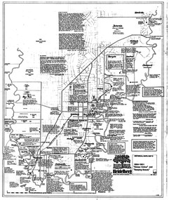 Greensborough Historical Society
Map, Heidelberg: Historic River Landscape Assessment. Historical maps. Map D 1864 -1901 "Sleepy Hollow" and "Sleeping beauty", 1985c
Geographical area of c. 35 sq. kilometres marked with physical features such as major roads, rivers, vegetation and properties, with locations and notes on the increasing number of farms, orchards and vineyards that had been developed in addition to pastoral runs. Bounded by Shire of Diamond Valley to the North, Darebin Creek to the West, and Plenty River to the East.Black and white sketch on white paper. Second copy 600 x 430 cm printed in black on semi-opaque paperheidelberg, heidelberg - maps -
 Greensborough Historical Society
Map, Heidelberg: Historic River Landscape Assessment. Historical maps. Map E 1901-1934 "A Time of projects and improvements", 1985c
Geographical area of around 35 sq. kilometres marked with physical features such as major roads, railways (new extension to Eltham), rivers and properties, also housing sub-divisions and community facilities such as hospitals, parks and sporting reserves and indications of new small scale industries such as dairying. Bounded by Shire of Diamond Valley to the North, Darebin Creek to the West and Plenty River to the East. Black and white sketch map on white paperheidelberg, heidelberg - maps -
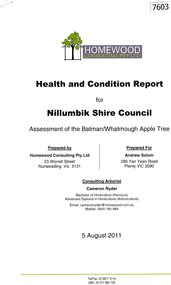 Greensborough Historical Society
Document - Report, Homewood Consulting Pty Ltd, Assessment of the Batman / Whatmough Apple Tree, 2011, 05/08/2011
A health and condition report for Nillumbik Shire Council on the Batman / Whatmough Apple Tree. Prepared by Homewood Consulting in 2011The Batman Apple tree is said to be over 170 years old, being brought to Greensborough in the 1840s from the Melbourne orchard of John Batman, following Batman's death in 1839.9 page photocopy, text and colour illustrations.batman apple tree, robert whatmough, nillumbik council, plenty river trail