Showing 119 items matching "australia economic development"
-
 Greensborough Historical Society
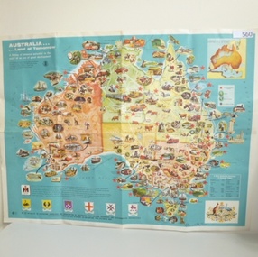
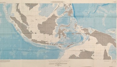
Map, International Harvester, Australia. Land of tomorrow, 1965_
... australia economic development...This 1960s map of Australia shows areas of economic development at that time....Greensborough Historical Society 34A Glenauburn Road Lower Plenty Lower Plenty melbourne This 1960s map of Australia shows areas of economic development at that time. australia economic development international harvester Colour map of Australia Australia. ...This 1960s map of Australia shows areas of economic development at that time.Colour map of Australiaaustralia economic development, international harvester -
 Phillip Island and District Historical Society Inc.
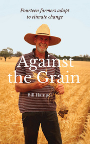
Book, Bill Hampel, Against the grain : fourteen farmers adapt to climate change, 2015
... farmers -- australia -- economic conditions....rural development...A summary of climate change impacts - and an account of the numerous economic, political, and media barriers toward change - combine to provide a context for their work. agriculture -- environmental aspects -- australia. farmers -- australia -- economic conditions. rural development -- australia. climatic changes -- australia. ...Can we humans simply ignore the fires, the floods, and the increase in deaths brought about by climate change? In this book, Australian farmers - who bear the brunt of climate change, yet accept the science - share their experiences with the unpredictable weather events, the reduction in rainfall, and the shift to hotter months which are a challenge to farming cycles. Far from contributing to the problem with their farming practices, these farmers demonstrate how to reduce their greenhouse gases - to zero or below in some cases - while remaining profitable. They are all committed to pass on their farm in a better condition than when they first purchased or inherited it. With crops or livestock, big or small, they have worked cooperatively, mostly through land management, to plant thousands of trees, which has led to the daily presence of over 100 bird species. The farmers' inspiring and informative stories will open up a new world to most urban dwellers. A summary of climate change impacts - and an account of the numerous economic, political, and media barriers toward change - combine to provide a context for their work. 280 pages : colour illustrations, colour maps, colour portraits ; 23 cm. Includes bibliographical references and index. Also available in digital formats: ebook & epdf. ISBN 9781925078503 Dewey number 338.10994 Chapter 5 : Bob & Anne Davie Donor : Anne Davie ; Date : 14.10.2015.agriculture -- environmental aspects -- australia., farmers -- australia -- economic conditions., rural development -- australia., climatic changes -- australia. -
 Warrnambool and District Historical Society Inc.
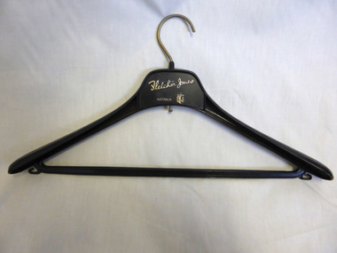
Domestic object - Fletcher Jones Coat Hanger, Late 20th century
... Australia to sell the garments. A common item linked to a significant business and personality of Warrnambool.Fletcher Jones Factory held a significant place in the economic development of the city. ...David Fletcher Jones commenced his tailoring and hawking business in the 1920’s. The business expanded through the decades to become the main manufacturing employer in the city of Warrnambool. The business moved from Liebig Street around 1947 to a site in East Warrnambool which was once an old quarry. The factory which was built at “Pleasant Hill” manufactured quality clothing, initially men’s trousers, suits which expanded in later times to include ladies’ wear. A network of stores was opened throughout Australia to sell the garments. A common item linked to a significant business and personality of Warrnambool.Fletcher Jones Factory held a significant place in the economic development of the city. The Fletcher Jones Gardens remain a significant landmark in the cityBlack plastic coat hanger with metal hook. Fletcher Jones in gold lettering below the hook.warrnambool, fletcher jones, pleasant hill, fletcher jones gardens, coathanger -
 Warrnambool and District Historical Society Inc.
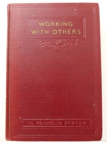
Book, Working with others, 1940s
... The Fletcher Jones business was important in Australia for over 50 years and played a key part in the economic development of Warrnambool in the second half of the 20th century as the city’s largest manufacturing business. ...This book belonged to Fletcher Jones and was later part of the library at the Fletcher Jones Factory Complex in Warrnambool. Fletcher Jones was a prominent Warrnambool businessman who established a men’s clothing shop in Warrnambool in the 1920s and a factory in Warrnambool in the 1940s. He extended this business Australia-wide and later included women’s clothing. He was noted for his philanthropy and for his interest in co-operative management and the participation of staff in the ownership of the business. This book is significant because it reflects the personal philosophies of Fletcher Jones who was a prominent Warrnambool businessman who advocated the participation of staff in the ownership of businesses. The Fletcher Jones business was important in Australia for over 50 years and played a key part in the economic development of Warrnambool in the second half of the 20th century as the city’s largest manufacturing business. Fletcher Jones was a significant person in Warrnambool in the 20th century. This is a hard cover book of 114 pages. It has nine chapters and a bibliography. The cover is red with gold and black lettering and part of the title embedded into the cover. There is a stamp of the Fletcher Jones business and an embossed one of Fletcher Jones’ home address. There is also evidence of library use. The inscription is handwritten in black ink. ‘Fletcher Jones & Staff Pty Ltd’ ‘Fletcher Jones, 2/7/44’ ‘Fletcher Jones, Raloda, 72 Jamieson St. Warrnambool’ fletcher jones, fletcher jones and staff pty ltd, history of warrnambool -
 Warrnambool and District Historical Society Inc.
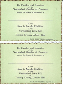
Document, Made in Australia Exhibition, 1950s
... economic development. These tickets are of some interest as an example of the activities of the Warrnambool Chamber of Commerce in the mid 20th century. made in australia exhibition, warrnambool warrnambool warrnambool chamber of commerce e Dempster ‘The President and Committee of the Warrnambool Chamber of Commerce requests the pleasure of the company of ….. at the Made in Australia Exhibition at the Warrnambool Town Hall on Thursday Evening, October 22nd, E. ...No information has been found regarding this exhibition in Warrnambool. The card design indicates that the exhibition may have been in the 1950s. The Warrnambool Chamber of Commerce has been operating at various times in the 20th century and was formed by the local businesses to promote Warrnambool as a city for business initiatives, tourism and economic development. These tickets are of some interest as an example of the activities of the Warrnambool Chamber of Commerce in the mid 20th century. These are two identical tickets, with black printing on a green background on one side and blank on the other side. The edges of the cards are gold- tipped in a serrated pattern.‘The President and Committee of the Warrnambool Chamber of Commerce requests the pleasure of the company of ….. at the Made in Australia Exhibition at the Warrnambool Town Hall on Thursday Evening, October 22nd, E. M. Dempster, Organizer’. made in australia exhibition, warrnambool, warrnambool, warrnambool chamber of commerce, e dempster -
 Bendigo Military Museum
Administrative record - International Map of the World (IMW) 1:1 Million Scale - H Ureta, Circa 1964, MR H Ereta, Post 1964
... Ereta, Chief of the Cartographic Section of the United Nations Department of Economic Development and Social Affairs gave a lecture on the IMW and described the history and development of the map series in post 1964. This document is a copy of that lecture. Royal Australian ...This document records the history of the International Map of the World (IMW) at 1:1Million Scale. Mr H. Ereta, Chief of the Cartographic Section of the United Nations Department of Economic Development and Social Affairs gave a lecture on the IMW and described the history and development of the map series in post 1964. This document is a copy of that lecture. 7 x Foolscap pages of typed text, stapled and two hole punched, Paper is dis-coloured.royal australian survey corps, rasvy, fortuna, army survey regiment, army svy regt, asr, imw -
 Kiewa Valley Historical Society
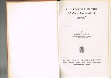
Book - Reference Teaching Infants, The Teacher in the Modern Elementary School, 1941
... Australian rural teachers with an advanced American approach to teaching methods. These methods were based on the then modern "group" psychological teachings and were a good guide in the development of a more effective and progressive teaching platform. The one thing that it did not address was the easy going Australian psyche of "she'll be right mate" of the Australia rural community. The socio-economic ...This teacher's aid publication was used by the teachers in the The Bogong Primary School from 1941 and also the Mount Beauty Primary School from its establishment in 1947. Both had most of their pupils recruited from SEC(Victoria) Hydro Electricity Scheme employees working for a limited time scale. Rural based children benefited greatly by the decision by the SEC to provide these facilities for their worker's families. This bypass of the "typical rural provisions" offered to other schools, by the Victorian Department of Education was a bonus to the Kiewa Valley educational community. These schools had a higher level of facilities available to them than other "typical" rural schools. Treasured facilities such as a comprehensive library, movie projector, tape recorder and public address system placed these two schools at the level of the Greater Public School of city or the larger towns rather than the small rural schools in Victoria.This item was used in Mount Beauty Primary School as part of a teacher's curriculum. The fact that it is in a rural area, in an enclosed SEC construction worker's village in the Kiewa Valley did present a slightly different learning atmosphere than in the larger towns and cities. The majority of parents within the Kiewa Valley, had a slight resentment of the "high and mighty" attitude of city dwellers with a "plum in their mouths" and the effectiveness that city bred teachers had to achieve was to overcome these ingrained mores. The majority of students at this primary school had parents who were working for (the closed "village" of the SEC Hydro Electricity Scheme. In the 1940s this school would have children from multi-cultural backgrounds as many of the parents were recruited as labourers or with European technical backgrounds. In the book,the black and white photographs detailing the classroom sizes and configurations point to larger classes and slightly different teaching methods than that which existed in Australia. This teacher's aid book presents the Australian rural teachers with an advanced American approach to teaching methods. These methods were based on the then modern "group" psychological teachings and were a good guide in the development of a more effective and progressive teaching platform. The one thing that it did not address was the easy going Australian psyche of "she'll be right mate" of the Australia rural community. The socio-economic identity of the Kiewa Valley rural community was not that of the typical city community (American) and this was a challenge for city based and trained teachers. The principles that the book presents is not constrained by the date of publication or its time of use (1954).This hard cardboard covered book is sleeveless but bound by a red cloth glued onto a thick cardboard base. It has the title printed in gold script on the spine with horizontal and fifteen black horizontal lines at the top and bottom. The front cover has the title printed in gold coloured letters (the first and last words are in freehand script style)On the spine and front cover is printed "The TEACHER IN THE MODERN ELEMENTARY School" school organisation, developmental stages of children, subliminal classroom mental and physical stimulation, usa 1940s teacher aids. -
 Emerald Museum & Nobelius Heritage Park
Award - Football Trophy, Nutting & Young, 1977
... Australian Rules football mounted on a stand was probably the same football that was used in the match. The football was manufactured by historic Victorian sports equipment makers, Nutting & Young, who ceased operations in 1977. This is an example of a creative sporting trophy which recognised an Emerald Football Club player's outstanding achievement. Local football and other sporting teams are often integral to the economic and social development ...The Emerald Football club history dates from 1904, and like many local clubs and organisations, has always played an important role in the community. This trophy was awarded to Geoff "Digger" Dolan of the Emerald Football Club for scoring 15 goals in a single match against the Woori Yallock Club on the 9th of July 1977. The match broke the club record at the time, resulting in 120 goals being scored in 12 matches from the 16th of April to 9th of July 1977. The trophy consisting of an Australian Rules football mounted on a stand was probably the same football that was used in the match. The football was manufactured by historic Victorian sports equipment makers, Nutting & Young, who ceased operations in 1977.This is an example of a creative sporting trophy which recognised an Emerald Football Club player's outstanding achievement. Local football and other sporting teams are often integral to the economic and social development of an area.A trophy consisting of an actual Australian Rules football secured onto a hard plastic stand with a metal clasp. A metal plaque on the stand is inscribed with the award details. The football is mounted in an upward and forward position as though ready to be kicked.On metal plaque inscribed: 'PRESENTED TO G. 'DIGGER' DOLAN / CLUB RECORD OF 15 GOALS IN A MATCH / AGAINST WOORI YALLOCK JULY 1977 / 102 GOALS IN 12 MATCHES / 16 APRIL 1977 - 5 JULY 1977' On the football, printed: 'Football made by Nutting & Young, Vic/ NFL APPROVED' Also on the football handwritten signatures of (presumably) other team membersemerald football club -
 Federation University Historical Collection
Book, Frank Hurley, An Event That Never Happened: The history and politics of decentralisation in Victorian and New South Wales 1885-1985 (Thesis), 1989
... Australia E.J. Barker Library (top floor) Mount Helen goldfields This thesis is an account of movements and policies for decentralisation of population and economic activity away from metropolitan to non-metropolitan areas in Victoria and New South Wales between 1885 and 1985. Frank hurley thesis doctorate decentralisation ppoulation economics policy Closer settlement acts urbanisation decentralisation league war and reconstruction central planning town planning victorian Decentralisatoin League Owen paper mill Slough Estate Noel Mobbs Ballarat Common Edgar Bartrop Australian Paper Mills Bendix Mintex ball ballarat development committee Red hard covered thesis undertaken for a Doctory of Philosphy ot the University of Melbourne. ...This thesis is an account of movements and policies for decentralisation of population and economic activity away from metropolitan to non-metropolitan areas in Victoria and New South Wales between 1885 and 1985. Red hard covered thesis undertaken for a Doctory of Philosphy ot the University of Melbourne. frank hurley, thesis, doctorate, decentralisation, ppoulation, economics, policy, closer settlement acts, urbanisation, decentralisation league, war and reconstruction, central planning, town planning, victorian decentralisatoin league, owen paper mill, slough estate, noel mobbs, ballarat common, edgar bartrop, australian paper mills, bendix mintex, ball, ballarat development committee -
Marysville & District Historical Society
THE TRIANGLE NEWS-VOL 36 NO 17-MAY 15 2009
... australia...greaternoosa qld assisting recovery...what's on when...marysville & district historical society meeting...new beginnings...radio murrindindi marysville...98.5FM...free tools...marysville resource recovery centre...cross country ski hire reopens...postcard from paris...advertisements...alexandra resource recovery centre...free bus service...television available to marysville...triangle distribution & fire relief centre...alexandra open gardens weekend...councillor comment...state government about turn in bushfire assistance...two new grants...murrindindi shire council...economic development...Marysville & District Historical Society 39 Darwin Street Marysville yarra-valley-and-the-dandenong-ranges marysville victoria australia greaternoosa qld assisting recovery what's on when marysville & district historical society meeting new beginnings radio murrindindi marysville 98.5FM free tools marysville resource recovery centre cross country ski hire reopens postcard from paris advertisements alexandra resource recovery centre free bus service television available to marysville triangle distribution & fire relief centre alexandra open gardens weekend councillor comment state government about turn in bushfire assistance two new grants murrindindi shire council economic development department alexandra vacancy marysville medical clinic help & support get together marysville golf club thank you gallipoli park beauty escape mary kay cosmetics alexandra visitors information centre marysville & district lions club community bbq THE TRIANGLE NEWS-VOL 36 NO 17-MAY 15 2009 ...marysville, victoria, australia, greaternoosa qld assisting recovery, what's on when, marysville & district historical society meeting, new beginnings, radio murrindindi marysville, 98.5fm, free tools, marysville resource recovery centre, cross country ski hire reopens, postcard from paris, advertisements, alexandra resource recovery centre, free bus service, television available to marysville, triangle distribution & fire relief centre, alexandra open gardens weekend, councillor comment, state government about turn in bushfire assistance, two new grants, murrindindi shire council, economic development department, alexandra vacancy, marysville medical clinic, help & support get together, marysville golf club, thank you, gallipoli park, beauty escape mary kay cosmetics, alexandra visitors information centre, marysville & district lions club, community bbq -
 Orbost & District Historical Society
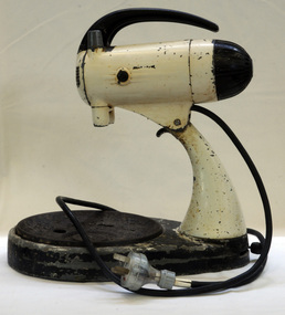
cake mixer, circa 1948
... Australia. It was designed in the USA. After years of rationing and shortages, the 1950s were a period of economic prosperity, high employment and great technological development. ...The Mixmaster 9B in 1948 was the first Sunbeam appliance to be made in Australia. It was designed in the USA.After years of rationing and shortages, the 1950s were a period of economic prosperity, high employment and great technological development. During this period, Australians enthusiastically adorned their homes with a dazzling range of new domestic appliances. Hire-purchase schemes allowed people to take products home and pay for them in instalments. The American-designed Mixmaster 9B was the first Sunbeam appliance manufactured and sold in Australia in 1948. An early Sunbeam Mixmaster. It is an electronic stand mixer with a black metal base in the shape of a rounded teardrop with two holes for the turntable. It has a cream enameled metal arm, cream coloured metal motor housing with a black plastic handle on the top. On the back of the motor housing is a black plastic knob with ten speed options for the mixer, and the "OFF" position. a black electric cord is attached under the motor housing with a black switch beneath the cord. The motor housing is able to tilt backwards on a hinge which is attached to the top of the stand arm. It is worked on AC or Dc power 240 On the bottom are the words "MODEL 9B". mixmaster sunbeam kitchen-appliance food-technology -
 Federation University Historical Collection
Map - Geological, U.S. Government Printing Office, Bathymetric Map of the Indonesian Region: Folio of the Indonesian Region Map I-875-A, 1974, 1974
... Australia E.J. Barker Library (top floor) Mount Helen goldfields Map was prepared on behalf of the Government of Indonesia, The United Nations Economic Commission for Asia and the Far East, the Agency for International Development and the U.S. ...Map was prepared on behalf of the Government of Indonesia, The United Nations Economic Commission for Asia and the Far East, the Agency for International Development and the U.S. Department of State in cooperation with the Geological Survey of Indonesia. The area covered shows the islands and seas from Latitude 12 degree North to 16 degrees South and Longitude 90 degrees to 148 degrees. Various water features are also named.Large map showing the Indonesian area - islands and seasLongitude and Latitude are shown. Major / Capitol cities indicated. Names of those responsible for the productionindonesia, united nations economic commission, department of state, geological survey, latitude, longitude, government of indonesia -
 Federation University Historical Collection
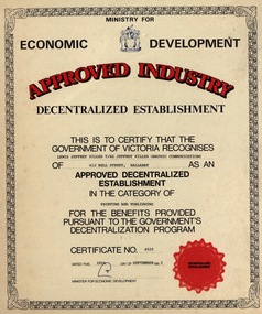
Certificate - Certificate - Approved Industry, ZILLES COLLECTION: Recognition by Victorian Government - Approved Decentralized Establishment, 1982
... Australia E.J. Barker Library (top floor) Mount Helen goldfields Zilles Printers was begun by Lewis Zilles in the early 1930s. It was in McKenzie Street Ballarat. His son Jeffrey also became a printer - letterpress, offset and screen printer. The business became Zilles Printers/Graphics and was in Armstrong Street and later Bell Street Ballarat. The Ministry for Economic Development ...Zilles Printers was begun by Lewis Zilles in the early 1930s. It was in McKenzie Street Ballarat. His son Jeffrey also became a printer - letterpress, offset and screen printer. The business became Zilles Printers/Graphics and was in Armstrong Street and later Bell Street Ballarat. The Ministry for Economic Development, Government of Victoria, awarded the Zilles family company the certificate for Approved Decentralized Establishment in the category of Printing and Publishing for the benefits provided pursuant to the Government's Decentraization Program. Dated 28th September 1982.Buff coloured card. Scroll edging, brown and red print.Symbol of government, red seal, signature. Certificate No 4525zilles printers, ballarat, minister of economic development, government of victoria, decentralized industry, award -
Glen Eira Historical Society
Article - Rosstown Railway
... Murray Ross Murray Sugar Beet Mills Mills Elsternwick Land Transport Railways Railway Lines Railway Routes Carnegie Neville Street Carnegie Miller Street Factories Market Gardens Horticulture Peat Soils Land Forms Topography Geology Civic Issues Cone Sugar Industry Elsternwick Plaza Elsternwick Glenhuntly Road Parks and Reserves EE Gunn Reserve Caulfield Racecourse Sportsgrounds Caulfield Carnegie Riddell Parade Clarence Street Aileen Avenue Princes Park Dover Street Marara Road Oakleigh Road Rosanna Street Murrumbeena Crescent North Road Kooyong Road Hawthorn Road Booran Road Koornang Road Poath Road Warragul Road Railway Platforms Railway Buildings Bambra Road Swamps Landforms Landfill Council Landfill Railway Bridges Bridges Railway Underpasses Sporting Clubs Tennis Clubs Bowls Clubs Rosstown Railway Rosanna Street Reserve Maps Railway Maps LIVING IN GLEN EIRA Weickhardt Ian Jowett Des Caulfield South Curraweena Road Oakleigh Caulfield Technical School RETURN TO ROSSTOWN Beet Sugar Industry Crops Land Booms Land Development and Subdivisions Bent Thomas Fink Benjamin Sugar Works Rosstown Hotel Oamdenong Road ROSSTOWN DRY CLEANERS Shops Rosstown Road Rosstown Plate People by Circumstance Migrants Accountants Occupations Professionals THE GRANGE Real Estate Grange Road Financial Agents Judges ROSSTOWN ESTATE Financial Trouble Rabbit Preserving Breweries Political Debates Political Issues Political Electorates Politics Political Science Debt Financial Loans Court Procedures Court Cases Legal Events and Activities MALLESON AND RIGGALL Widowers SEABEACH RAILWAY Economics Economic Deadline Depression 1890s Economic Crash Mortgages Divorce Social Problems Poverty Ross Claude Ross Roderick World War 1914-1918 Wars Military History Servicemen AUSTRALIAN FLYING CORPS Engineers Caulfield Council Swagmen Homelessness Glenhuntly Road Glenhuntly Road Tram Woornack Road Leila Road Wild Cherry Road Melten Avenue Illustrations Steam Trains Trains Horse and Cart Horse-drawn Transport Railway Stations Article Rosstown Railway ...This file contains three items: 1/A review of the ROSSTOWN RAIL TRAIL from LIVING IN GLEN EIRA, vol. 11, 2004, Issue 4, no. 25, date and author unknown. The review explains the purpose of the Rail Trail with a brief narrative of the history behind Rosstown Sugar Mill Railway line. Concluding with information on the location of the Trail and the expected time required to walk the entire track included in the review is a map of the Rail Trail, which marks significant sites along the trail with historic pictures. 2/A newspaper article from THE AGE, dated Tuesday 21/10/1980 and written by Iola Matthews, reporting on the circumstances that led to the publication of the book RETURN TO ROSSTOWN written by Des Jowett and Ian Weickhardt. The article begins with a brief biography of the authors before moving into details of the book’s content, providing a further biography of W. Murray Ross which includes information on his financial ventures – particularly the Rosstown Rail – his marriage and children. The article includes a black and white photograph of Weickhardt and Jowett walking along the route of the railway line, an illustration of the Rosstown sugar works and a map of the area surrounding the site of the mill. 3/Three photocopies of a black and white illustration of the Rosstown sugar works from the east, undated and artist unknown.rosstown rail trail, rosstown, ross william, ross w. murray, ross murray, sugar beet mills, mills, elsternwick, land transport, railways, railway lines, railway routes, carnegie neville street, carnegie miller street, factories, market gardens, horticulture, peat, soils, land forms, topography, geology, civic issues, cone sugar industry, elsternwick plaza, elsternwick, glenhuntly road, parks and reserves, ee gunn reserve, caulfield racecourse, sportsgrounds, caulfield, carnegie, riddell parade, clarence street, aileen avenue, princes park, dover street, marara road, oakleigh road, rosanna street, murrumbeena crescent, north road, kooyong road, hawthorn road, booran road, koornang road, poath road, warragul road, railway platforms, railway buildings, bambra road, swamps, landforms, landfill, council landfill, railway bridges, bridges, railway underpasses, sporting clubs, tennis clubs, bowls clubs, rosstown railway, rosanna street reserve, maps, railway maps, living in glen eira, weickhardt ian, jowett des, caulfield south, curraweena road, oakleigh, caulfield technical school, return to rosstown, beet sugar industry, crops, land booms, land development and subdivisions, bent thomas, fink benjamin, sugar works, rosstown hotel, oamdenong road, rosstown dry cleaners, shops, rosstown road, rosstown plate, people by circumstance, migrants, accountants, occupations, professionals, the grange, real estate, grange road, financial agents, judges, rosstown estate, financial trouble, rabbit preserving, breweries, political debates, political issues, political electorates, politics, political science, debt, financial loans, court procedures, court cases, legal events and activities, malleson and riggall, widowers, seabeach railway, economics, economic deadline, depression 1890s, economic crash, mortgages, divorce, social problems, poverty, ross claude, ross roderick, world war 1914-1918, wars, military history, servicemen, australian flying corps, engineers, caulfield council, swagmen, homelessness, glenhuntly road, glenhuntly road tram, woornack road, leila road, wild cherry road, melten avenue, illustrations, steam trains, trains, horse and cart, horse-drawn transport, railway stations -
 The Beechworth Burke Museum
Audio - Oral History, Jennifer Williams, Mavis Jensen, 11 May 2000
... She details important historical events and hardships in the region's history that had a lasting local, regional and national impact, including Australia during war time, economic struggles, and women's societal roles in a rural area. Her oral history is particularly significant for its insights into developments in psychiatric patient treatment and care in regional Victoria, as well as women's work conditions in the mid-twentieth century. ...Mavis Jensen (nee Knight) was born in Broadford in 1920 and came to Beechworth with her family a year later, so her father could assist his father at Knight's Blacksmith at 1A Camp Street, where the Hotel Nicholas is now located. Mavis Jensen left school at the age of 13 and worked as a kitchen maid at Ovens Benevolent Asylum. She was employed as a ward assistant at Mayday Hills Hospital from 1939 to 1980, except for 1958-59 when she gave birth to her son, Noel. This oral history recording was part of a project conducted by Jennifer Williams in the year 2000 to capture the everyday life and struggles in Beechworth during the twentieth century. This project involved recording seventy oral histories on cassette tapes of local Beechworth residents which were then published in a book titled: Listen to what they say: voices of twentieth century Beechworth. These cassette tapes were digitised in July 2021 with funds made available by the Friends of the Burke.Mavis Jensen's account of her life in Beechworth and the local area during the 20th century is historically and socially significant to the cultural heritage of the region. She details important historical events and hardships in the region's history that had a lasting local, regional and national impact, including Australia during war time, economic struggles, and women's societal roles in a rural area. Her oral history is particularly significant for its insights into developments in psychiatric patient treatment and care in regional Victoria, as well as women's work conditions in the mid-twentieth century. This oral history account is socially and historically significant as it is a part of a broader collection of interviews conducted by Jennifer Williams which were published in the book 'Listen to what they say: voices of twentieth-century Beechworth.' While the township of Beechworth is known for its history as a gold rush town, these accounts provide a unique insight into the day-to-day life of the town's residents during the 20th century, many of which will have now been lost if they had not been preserved.This is a digital copy of a recording that was originally captured on a cassette tape. The cassette tape is black with a horizontal white strip and is currently stored in a clear flat plastic rectangular container. It holds up 40 minutes of recordings on each side.Mavis Jensen /listen to what they say, beechworth, oral history, burke museum, jensen, mavis jensen, psychiatric hospitals, mid-twentieth century psychiatry, regional hospitals, regional mental health care, mid-twentieth century women's working conditions, mayday hills hospital., ovens benevolent asylum, beechworth hospital history -
The Beechworth Burke Museum
Audio - Oral History, Jennifer Williams, Fred and Bette Wyatt, 27 April 2000
... They both mention important historical events and hardships in the region's history that had a lasting local, regional and national impact, including Australia during wartime, economic struggles, and the development of Beechworth town. ...Fred was born on the 1st of March 1928 and Bette in 1934, in Beechworth. Both of their families immigrated from England on convict ships in the 1800s. Fred and Bette both had large families of 9 and 5 siblings respectively, with 2 of Fred's siblings suffering from muscular dystrophy both dying at 20 years old which affected the family. Bette originally worked in multiple cafes and kitchens in Beechworth before working in "Ennals Store" which was a grocery store, for over 30 years. Fred worked as a milkman during the war before becoming an engineer at the tannery and the brewery in Beechworth. He rebuilt the factory at the brewery during the 1970s and worked there until he retired. This oral history recording was part of a project conducted by Jennifer Williams in the year 2000 to capture the everyday life and struggles in Beechworth during the twentieth century. This project involved recording seventy oral histories on cassette tapes of local Beechworth residents which were then published in a book titled: Listen to what they say: voices of twentieth century Beechworth. These cassette tapes were digitised in July 2021 with funds made available by the Friends of the Burke.Fred and Bette Wyatt's account of their lives in Beechworth and the local area during the 20th century is historically and socially significant to the cultural heritage of the region. They both mention important historical events and hardships in the region's history that had a lasting local, regional and national impact, including Australia during wartime, economic struggles, and the development of Beechworth town. This oral history account is socially and historically significant as it is a part of a broader collection of interviews conducted by Jennifer Williams which were published in the book 'Listen to what they say: voices of twentieth-century Beechworth.' While the township of Beechworth is known for its history as a gold rush town, these accounts provide a unique insight into the day-to-day life of the town's residents during the 20th century, many of which will have now been lost if they had not been preserved.This is a digital copy of a recording that was originally captured on a cassette tape. The cassette tape is black with a horizontal white strip and is currently stored in a clear flat plastic rectangular container. It holds up 40 minutes of recordings on each side.Fred and Bette Wyattbeechworth, beechworth tannery, beechworth brewery, fred and bette wyatt, wyatt, wyatt beechworth, ennals store, ennals beechworth, listen to what they say, burke museum -
 The Beechworth Burke Museum
Photograph, 1960s
... Caravanning was extremely popular during the 1960s in Australia due to multiple social and economic factors including the stopping of fuel rations, the accessibility of car ownership through the manufacturing of affordable cars, technological developments in caravan design, and the increase in prosperity and leisure time for many Australians. ...This photograph was taken in the 1960s at Lake Sambell Caravan Park and visible in the photograph are individual caravan sites with electricity outlets, a large single-story building with a caravan park banner, dirt roads, a freestanding message board, and a parked car. Lake Sambell Caravan Park opened in 1959 owing to the work of R.E. Carter, Beechworth Shire engineer from 1954-63. Carter advocated for improvements to the lake and surrounding area in order to encourage tourism in Beechworth. The opening of the caravan park was part of many improvements to Lake Sambell made in this period by Carter including: the swimming pool in 1961, water skiing and boating facilities, and increased lake surface in 1964. These improvements were financed mainly by grants from the Tourist Development Authority. The popularity of caravanning in Australia exploded during this post-war period of the late 1950s and 1960s. This popularity was driven by multiple factors, including: the stopping of fuel rations, the accessibility of car ownership through the manufacturing of affordable cars, technological developments in caravan design, and the increase in prosperity and leisure time for many Australians. Facilities such as electrical outlets to power caravans are present in this photograph of Lake Sambell Caravan Park. Lake Sambell is an artificial lake that was developed on the previous site of the Rocky Mountain Mining Company workings and was officially opened by Minister for Lands, Mr Baily, on October 5, 1928. The disused and unattractive remains of the mine were converted into a recreational area intended for swimming, boating, and fishing. The lake is named after Mr L.H. Sambell, shire engineer and secretary of the Forward Beechworth Committee, who advocated for the enhancement of Beechworth into a tourist destination and was central to the planning and establishment of the lake. This photograph is of historical and social significance in providing insight into caravanning during the 1960s in Australia. Caravanning was extremely popular during the 1960s in Australia due to multiple social and economic factors including the stopping of fuel rations, the accessibility of car ownership through the manufacturing of affordable cars, technological developments in caravan design, and the increase in prosperity and leisure time for many Australians.Black and white rectangle photograph printed on photographic paper and unmounted.Reverse: 3536/ [logo back printing: KODAK/ VELOX/ PAPER] / C798 lake sambell caravan park, lake sambell, caravanning 1960s, caravan park, rocky mountain mining company, kodak velox paper, r.e. carter, l.h. sambell, caravan electricity outlets, tourist development authority, post-war prosperity, forward beechworth committee, lake sambell boating, lake sambell swimming pool, lake sambell fishing, artificial lake, travel 1960s, recreation 1960s -
 The Beechworth Burke Museum
Photograph, 1960s
... Caravanning was extremely popular in Australia during the late 1950s and 60s due to multiple social and economic factors including the stopping of fuel rations, the accessibility of car ownership through the manufacturing of affordable cars, technological developments in caravan design, and the increase in prosperity and leisure time for many Australians. ...This photograph was taken in the 1960s at Lake Sambell Caravan Park, visible in the photograph are individual caravan sites with electricity outlets, a large single-story building, a parked car, and two caravans partially obstructed by trees. Lake Sambell Caravan Park opened in 1959 owing to the work of R.E. Carter, Beechworth Shire engineer from 1954-63. Carter advocated for improvements to the lake and surrounding area in order to encourage tourism in Beechworth. The opening of the caravan park was part of many improvements to Lake Sambell made in this period by Carter including: the swimming pool in 1961, water skiing and boating facilities, and increased lake surface in 1964. These improvements were financed mainly by grants from the Tourist Development Authority. The popularity of caravanning in Australia exploded during this post-war period of the late 1950s and 1960s. This popularity was driven by multiple factors, including: the stopping of fuel rations, the accessibility of car ownership through the manufacturing of affordable cars, technological developments in caravan design, and the increase in prosperity and leisure time for many Australians. Facilities such as electrical outlets to power caravans are present in this photograph of Lake Sambell Caravan Park. Lake Sambell is an artificial lake that was developed on the previous site of the Rocky Mountain Mining Company workings and was officially opened by Minister for Lands, Mr Baily, on October 5, 1928. The disused and unattractive remains of the mine were converted into a recreational area intended for swimming, boating, and fishing. The lake is named after Mr L.H. Sambell, shire engineer and secretary of the Forward Beechworth Committee, who advocated for the enhancement of Beechworth into a tourist destination and was central to the planning and establishment of the lake. This photograph is of historic and social significance in documenting the enhancement of the Lake Sambell area overseen by R.E. Carter and providing insight into caravanning during the 1960s in Australia. Caravanning was extremely popular in Australia during the late 1950s and 60s due to multiple social and economic factors including the stopping of fuel rations, the accessibility of car ownership through the manufacturing of affordable cars, technological developments in caravan design, and the increase in prosperity and leisure time for many Australians. Black and white rectangle photograph printed on photographic paper and unmounted.Reverse: 3538/ [logo back printing KODAK/ VELOX/ PAPER] / C798lake sambell caravan park, lake sambell, lake sambell 1960s, lake sambell fishing, lake sambell boating, lake sambell swimming pool, r.e. carter, l.h. sambell, tourist development authority, caravanning 1960s, caravan electricity outlets, caravan park, forward beechworth committee, rocky mountain mining company, lake caravan park, caravan mid 20th century, beechworth tourism, travel in the 1960s, holiday 1960s -
 Greensborough Historical Society
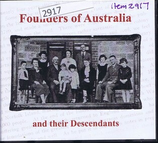
Audio - Compact disc, Founders of Australia and their descendants, 2007_
... Book 1: discovery, exploration, settlement and economic development of Australia; Book 2: biographical details of early emigrants and pioneering families...Greensborough Historical Society 34A Glenauburn Road Lower Plenty Lower Plenty melbourne Book 1: discovery, exploration, settlement and economic development of Australia; Book 2: biographical details of early emigrants and pioneering families australian history settlers colonisation european settlement family history pioneers Founders of Australia and their descendants Compact disc in plastic case with printed, paper-insert cover Founders of Australia and their descendants Audio Compact disc Archive CD Books Australia Pty Ltd ...Book 1: discovery, exploration, settlement and economic development of Australia; Book 2: biographical details of early emigrants and pioneering familiesCompact disc in plastic case with printed, paper-insert coverFounders of Australia and their descendantsaustralian history, settlers, colonisation, european settlement, family history, pioneers -
 Mission to Seafarers Victoria
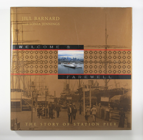
Book - Reference book, Jill Barnard et al, Welcome and Farewell: The Story of Station Pier, 2004
... development. The Government wanted a history that would also speak to ordinary Victorians, and other Australians, of their own experiences of this significant place. For indeed the Station Pier site has played its part in almost every milestone or phase in our history: at moments of celebration and commemoration, during economic booms and depressions, during times of war and peace. ...In the mid-nineteenth century, Victoria’s primitive maritime infrastructure was not coping with the volume of passenger and cargo traffic arriving in and departing from the burgeoning gold-fevered colony. However, the opening of Railway Pier at Port Melbourne in 1854 greatly improved the situation. Railway Pier serviced the steamships, which plied Port Phillip Bay and the Victorian coastal waters beyond, and also offered berths for vessels on the regular runs to other Australian colonies and to overseas destinations. However, as the larger and more powerful steamships of the early twentieth century found berthing increasingly difficult at Railway Pier, the need for a more modern pier became apparent. By 1930, the new Station Pier had replaced its predecessor. Itself extended and upgraded several times including during the past decade, Station pier still offers every contemporary convenience to shipping services using its busy facilities, just as did its predecessor Railway Pier, 150 years ago. The Victorian Government commissioned Welcome & Farewell to celebrate the 150 years since the opening of the Railway Pier. In doing so, it was mindful that the story of the site is not limited to its contribution to national and state economies, or to its physical development. The Government wanted a history that would also speak to ordinary Victorians, and other Australians, of their own experiences of this significant place. For indeed the Station Pier site has played its part in almost every milestone or phase in our history: at moments of celebration and commemoration, during economic booms and depressions, during times of war and peace. It has also won a place in the hearts of ordinary individuals affected by the welcomes and farewells they have experienced there: those for visiting royalty and celebrities, for servicemen and medical personnel off to war or returning home, for migrants from distant countries and refugees from war zones, for friends and family travelling for personal, professional or cultural reasons. Welcome & Farewell thoughtfully examines Station Pier’s significance and offers a splendid visual panorama of the experiences lived out there between 1854 and 2004.Illustrated large-format book with 224 pages [36] p. of plates. : ill., maps, ports.Bibliography: p. 199-201non-fictionIn the mid-nineteenth century, Victoria’s primitive maritime infrastructure was not coping with the volume of passenger and cargo traffic arriving in and departing from the burgeoning gold-fevered colony. However, the opening of Railway Pier at Port Melbourne in 1854 greatly improved the situation. Railway Pier serviced the steamships, which plied Port Phillip Bay and the Victorian coastal waters beyond, and also offered berths for vessels on the regular runs to other Australian colonies and to overseas destinations. However, as the larger and more powerful steamships of the early twentieth century found berthing increasingly difficult at Railway Pier, the need for a more modern pier became apparent. By 1930, the new Station Pier had replaced its predecessor. Itself extended and upgraded several times including during the past decade, Station pier still offers every contemporary convenience to shipping services using its busy facilities, just as did its predecessor Railway Pier, 150 years ago. The Victorian Government commissioned Welcome & Farewell to celebrate the 150 years since the opening of the Railway Pier. In doing so, it was mindful that the story of the site is not limited to its contribution to national and state economies, or to its physical development. The Government wanted a history that would also speak to ordinary Victorians, and other Australians, of their own experiences of this significant place. For indeed the Station Pier site has played its part in almost every milestone or phase in our history: at moments of celebration and commemoration, during economic booms and depressions, during times of war and peace. It has also won a place in the hearts of ordinary individuals affected by the welcomes and farewells they have experienced there: those for visiting royalty and celebrities, for servicemen and medical personnel off to war or returning home, for migrants from distant countries and refugees from war zones, for friends and family travelling for personal, professional or cultural reasons. Welcome & Farewell thoughtfully examines Station Pier’s significance and offers a splendid visual panorama of the experiences lived out there between 1854 and 2004.port melbourne, station pier -
 Bendigo Historical Society Inc.
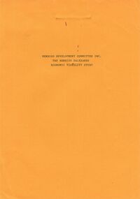
Document - BENDIGO SALEYARDS COLLECTION: THE BENDIGO SALEYARDS ECONOMIC VIABILITY STUDY
... Economic Viability Study... Bendigo Development Committee Inc.... Kate Millard... Loddon Campaspe Planning Authority... Street... Ryan and Associates... Bendigo City Council... Strathfieldsaye Shire Council... Department of Industry Technology & Resources... National Library of Australia...Economic Viability Study Bendigo Development Committee Inc. Kate Millard Loddon Campaspe Planning Authority Street Ryan and Associates Bendigo City Council Strathfieldsaye Shire Council Department of Industry Technology & Resources National Library of Australia Meldrum Burows & Partners Core Wilson Sayer Town Planning Appeals Panel CES Victorian Farmers and Graziers Association Stock Agents Association Department of Agriculture Department of Industry Technology & Resources Department of Conservation Forests and Land Cr Jock Comini RCA Depot Wellsford Rifle Range Bendigo Airport Bendigo Field Naturalists Club Mr David Kennedy Mr John Brumby Mr John Radford Neil O'Keefe Bendigo East Progress Association Bendigo East Traders Trades Hall Council Mr Tom Uren Mr Frank Wilkes Mr Bruce Reid Mr K I M Wright Mr E T Ebery Bendigo Pastoral Council of the VFGA Victorian Meatworks Association Bendigo Stock & Station Agents Association Rutlands Transport Mr Don Pickles Country Abattoirs & Wholesalers Association Association of Victoria Meat and Allied Trade Federation of Australia Bendigo Saleyards Advisory Committee Bendigo Residents & Ratepayers Association A H & N Graham Mrs P Unmack Australian Bureau of Statistics Mr Lloyd Houlden Cr C Rodda Mr Jolly Mr Tony Milanese Dr Robert Carter University of Melbourne Bendigo College of TAFE T Matthews A S & R D Rutland John Kerr J Talbot G L O'Sullivan Penney & Lang Pty Ltd Graeme Pickering Pickhall J W & Sons R A Plant W K Schmidt T J Vick K & J Wignall A E Wright G Chapman A J Gillies P G & M M Harris Ian R Hollingsworth B Kennedy S Letcher S & D K Letcher P M Llewellyn L G Mason Boyer R T Connally M F Kennedy & Mortlock Nevins J P R W Johnstone W J Keith B D Kelly Notman R Pitts A J & C A Pitts Mervyn L & Co Rowe W O Warren K M Associated Stock & Station Agents Dalgety Farmers Ltd Elders DSM Estates Ellis Nuttall & Co Gallagher G D Hamilton Real Estate McGregor Ralph H & Co McKean W & Co Miller Turner Livestock Co Vains E M & Co Victorian Producers Hill M J & Co Bennetts Meats Comell Bros Davis B & D Hardwick G F & V C Penney & Lang P/L Tendercut Meats Northern Seed Supply Co Bendigo Fertilizers Agri Business Pty Ltd Agrilink Consulting Group Pty Ltd Acil Aust Pty Ltd McGowan & Associates Chapman W C Talbot E J McCulloch W & Sons Pty Ltd K V Equipment Commercial Egg Producers Assoc Co-op Monsanto Aust Ltd Balmer Bryan R Barry I J Bath L Clarke B J Treacy K M Turner J M Bendigo Mower Serv Pty Ltd Everlast Concrete Tank tyLtd Wicks Bros canvas Goods Don McArthur Bendigo Communications Transcom Emdell Pty Ltd Epsom Pharmaceutical Supplies Sandhurst Fencing Pty Ltd Arnolds Gates & Fencing R Furniss Carne Neville AWA & UNICLA AJM Refrigeration bendigo Concrete Sawing Service Hamilton R J Hearpes T W J E Brown Campey DR A R Fyffe J J Kangaroo Flat Vet Clinic Ottrey K E Bendigo Sprinkler Installations Milnes Irrigation Onga Pumpshop Barastoc Products Bush's Produce Stores Epsom Produce K M M Pty Ltd Bendigo Grain Co Eaglehawk Chaff Mills Grain Elevators Board Dept Bonneys Pest Control Knights Pest Control Brown Wk & L d Bendigo Sewerage Authority Bendigo Water Board ACI Computer Services Leham Donald A E Hueffer & Associates Wolmoke Planners P Langley Mr Ken Strachan Mr Evan Jones Mr Peter Byrnes Mr Wayne Street Street Ryan & Associates 140 Loose pages titled The Bendigo Saleyards Economic Viability Study. ...140 Loose pages titled The Bendigo Saleyards Economic Viability Study. Report written by Kate Millard on behalf of the Bendigo Development Committee Inc. Contents include: Chapter 1 - Background Information, Chapter 1 - Present Operations at the Saleyards, Chapter 3 - Economic Factors, Chapter 4 - Environmental Factors, Chapter 5 - Selling Techniques, Chapter 6 - Employment Study, Management and Sundry Issues, Chapter 7 - Survey of Farmers and Saleyard Users in the 'Catchment Area', and Chapter 8 - Recommendations of the Report. Includes diagrams and maps. Recommendations printed on dark yellow paper.bendigo, council, cattle markets, bendigo saleyards collection - the bendigo saleyards economic viability study, bendigo development committee inc., kate millard, loddon campaspe planning authority, street, ryan and associates, bendigo city council, strathfieldsaye shire council, department of industry technology & resources, national library of australia, meldrum burows & partners, core wilson sayer, town planning appeals panel, ces, victorian farmers and graziers association, stock agents association, department of agriculture, department of industry technology & resources, department of conservation forests and land, cr jock comini, rca depot, wellsford rifle range, bendigo airport, bendigo field naturalists club, mr david kennedy, mr john brumby, mr john radford, neil o'keefe, bendigo east progress association, bendigo east traders, trades hall council, mr tom uren, mr frank wilkes, mr bruce reid, mr k i m wright, mr e t ebery, bendigo pastoral council of the vfga, victorian meatworks association, bendigo stock & station agents association, rutlands transport, mr don pickles, country abattoirs & wholesalers association association of victoria, meat and allied trade federation of australia, bendigo saleyards advisory committee, bendigo residents & ratepayers association, a h & n graham, mrs p unmack australian bureau of statistics, mr lloyd houlden, cr c rodda, mr jolly, mr tony milanese, dr robert carter, university of melbourne, bendigo college of tafe, t matthews, a s & r d rutland, john kerr, j talbot, g l o'sullivan, penney & lang pty ltd, graeme pickering, pickhall j w & sons, r a plant, w k schmidt, t j vick, k & j wignall, a e wright, g chapman, a j gillies, p g & m m harris, ian r hollingsworth, b kennedy, s letcher, s & d k letcher, p m llewellyn, l g mason, boyer r t, connally m f, kennedy & mortlock, nevins j p, r w johnstone, w j keith, b d kelly, notman r, pitts a j & c a, pitts mervyn l & co, rowe w o, warren k m, associated stock & station agents, dalgety farmers ltd, elders dsm estates, ellis nuttall & co, gallagher g d, hamilton real estate, mcgregor ralph h & co, mckean w & co, miller turner livestock co, vains e m & co, victorian producers, hill m j & co, bennetts meats, comell bros, davis b & d, hardwick g f & v c, penney & lang p/l, tendercut meats, northern seed supply co, bendigo fertilizers, agri business pty ltd, agrilink consulting group pty ltd, acil aust pty ltd, mcgowan & associates, chapman w c, talbot e j, mcculloch w & sons pty ltd, k v equipment, commercial egg producers assoc co-op, monsanto aust ltd, balmer bryan r, barry i j, bath l, clarke b j, treacy k m, turner j m, bendigo mower serv pty ltd, everlast concrete tank tyltd, wicks bros, canvas goods, don mcarthur, bendigo communications, transcom, emdell pty ltd, epsom pharmaceutical supplies, sandhurst fencing pty ltd, arnolds gates & fencing, r furniss, carne neville, awa & unicla, ajm refrigeration, bendigo concrete sawing service, hamilton r j, hearpes t w, j e brown, campey dr a r, fyffe j j, kangaroo flat vet clinic, ottrey k e, bendigo sprinkler installations, milnes irrigation, onga pumpshop, barastoc products, bush's produce stores, epsom produce, k m m pty ltd, bendigo grain co, eaglehawk chaff mills, grain elevators board dept, bonneys pest control, knights pest control, brown wk & l d, bendigo sewerage authority, bendigo water board, aci computer services, leham donald, a e hueffer & associates, wolmoke planners, p langley, mr ken strachan, mr evan jones, mr peter byrnes, mr wayne street, street ryan & associates -
 Bendigo Historical Society Inc.
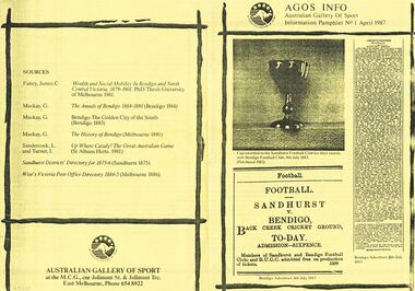
Document - AGOS INFO, BENDIGO, April 1987
... Australian game at a crucial stage of its development.. . Trophy presented by local jeweler, Mr Joseph Moody. .. Football was relatively weaker in Bendigo than in the comparable city of Ballarat. This can be explained by the high migrant proportion of the Bendigo population, its economic...Australian stage development.. . Trophy local jeweler Mr Joseph Moody. .. Football weaker in Bendigo than in Ballarat. explained by the migrant proportion Bendigo population its economic difficulties 1880s distance from Melbourne.. ...AGOS INFO, Bendigo. Australian Gallery of Sport. Information Pamphlet No. 1 April 1987. Photo of cup awarded to the Sanhurst Football Club for their victory over Bendigo Football Club, 4th July 1883. (Purchased 1987). Extract from Bendigo Advertiser, 4th July 1883 advertising Match between Sandhurst and Bendigo. Admission - Sixpence. Members of Sanhurst & Bendigo Football Clubs and BUCC admitted free on production of tickets. Extract of Bendigo Advertiser, 5th July 1883, FOOTBALL Sandhurst v. Bendigo. (remainder of print too small to read. Sandhurst. Bendigo July 4th 1883 The match played between Sandhurst and Bendigo provides a rare insight into the Australian game at a crucial stage of its development.. . Trophy presented by local jeweler, Mr Joseph Moody. .. Football was relatively weaker in Bendigo than in the comparable city of Ballarat. This can be explained by the high migrant proportion of the Bendigo population, its economic difficulties in the 1880s and by its distance from Melbourne. .. Football overtook cricket by the end of the decade as the most popular sport. .. A regular Saturday competition was played, with matches also played on Wednesdays. These matches were a legacy of the earliest ''scratch'' matches, suggesting a relatively strong union movement which had won concessions for weekend work. Matches started at 3pm. ..The best player on the ground was a contractor and the captain an accountant. .. Transition. The predominance of the ''little mark'' the participation of sometimes frightened junior teams against adults and the division of the game into halves rather than quarters represents an era that has disappeared. Complaints of rough play, poor losers, the problems posed by children. .. An issue, was seen as a blight on the game in 1883. The greatest offender, alleged by ''Drop-Kick'' in The Bendigo Advertiser, was Sheldon of Sandhurst, an ancestor of current day player Ken Sheldon of St Kilda. .. Fundamental issue about the place of sport in society. .. The reason for this is that the Bendigo club was in dispute with the Bendgio Union Cricket Club over control of the Back Creek Ground. If they had been refused the ground, as it was feared, then the whole association would have been forced to disband. Only last minute negotiations resolved the dispute. .. Reflects the values of society, .. Broader conflicts about power and the control of resources within that society. 2000 turned out. The crowd cheered lustily and the players exhibited similar excitement and were urged on by their captains to play up and kick the ball. In the eventual Sanhurst victory, amongst the best players was Edward Cordner, a forerunner of the renowned Cordner family of the Melbourne Football Clubs. Shane Cahill. Sources: Fahey, James C. Wealth and Social Mobility In Bendigo and North Central Victoria, 1868-1891. Mackay, G. The Annals of Bendigo 1868-1891 (Bendigo 1914). Mackay, G. Bendigo The Golden City of the South (Bendigo 1893) Mackay, G. The History of Bendigo (Melbourne 1891). Sandercock, L.. And Turner, I. Up Where Cazaly? The Great Australian Game (St Albans Herts. 1981) Sanhurst Districts' Directory for 1875-6 (Sandhurst 1875) Wise's Victoria Post Office Directory 1884-5 (Melbourne 1886). Australian Gallery Of Sport at the MCG, cnr Joliment St. & Joliment Trc. East Melbourne, Phone 654 8922.clubs and associations, football, agos, agos info, bendigo. australian gallery of sport. information pamphlet no. 1 april 1987. photo cup awarded sanhurst football club for victory bendigo football club, 4th july 1883. (purchased 1987). advertiser, 4th july 1883 match between sandhurst v. bendigo. admission - sixpence. members sanhurst & bendigo football clubs and bucc free. extract, 5th july 1883, football sandhurst v. bendigo. sandhurst. bendigo july 4th 1883 sandhurst and bendigo provides insight into the australian stage development.. . trophy local jeweler, mr joseph moody. .. football weaker in bendigo than in ballarat. explained by the migrant proportion bendigo population, its economic difficulties 1880s distance from melbourne.. football overtook cricket by end decade the popular sport.. saturday competition played, matches also wednesdays. legacy of the earliest ''scratch'' matches, strong union movement concessions for weekend work. matches started at 3pm.. best player on the ground a contractor the captain accountant. .. transition. predominance ''little mark'' participation frightened junior teams adults game halves rather than quarters represents an era disappeared. complaints rough play, poor losers, problems posed children., a blight 1883. offender, ''drop-kick'', sheldon, ancestor ken sheldon of st kilda...bendigo club was in dispute bendgio union cricket club control of the back creek ground. refused, as it was feared, association forced to disband. negotiations resolved dispute..values of society.. conflicts power control resources. 2000 turned out. crowd cheered players exhibited similar excitement captains. edward cordner. cordner family melbourne football clubs. shane cahill. sources: fahey, james c. wealth and social mobility in bendigo and north central victoria, 1868-1891. mackay, g. the annals of bendigo 1868-1891 (bendigo 1914). mackay, g. bendigo the golden city of the south (bendigo 1893) mackay, g. the history of bendigo (melbourne 1891). sandercock, l.. and turner, i. up where cazaly? the great australian game (st albans herts. 1981) sanhurst districts' directory for 1875-6 (sandhurst 1875) wise's victoria post office directory 1884-5 (melbourne 1886). australian gallery of sport at the mcg, cnr joliment st. & joliment trc. east melbourne, phone 654 8922. -
 Flagstaff Hill Maritime Museum and Village
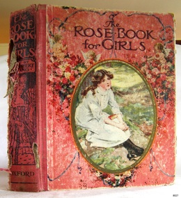
Book - Fiction, Mrs Herbert Strang, editor, The Rose Book for Girls, 1916
... Australia, particularly those from Victoria and the Warrnambool district in southwest Victoria. It is a tangible link to the history and legacy of these early settlers, who were instrumental in shaping the regional development. In addition, the book is notable for its connection to the McCullagh family, a prominent farming family whose contributions supported the social and economic growth of the local district. ...Alma McCullagh was a student at the Presbyterian Sabbath School located in Dennington, near Warrnambool. In January, around 1928, she received a book as an award from R. Conn, her Sabbath School teacher, in recognition of her involvement and achievements at the school. The exact year of this award is based on available records: in January 1928, Alma was presented with a prize by R. Conn, whereas by 1930, the role of awarding prizes had passed to F. Jones. Alma was probably the granddaughter of James McCullagh (1831–1911) and Elizabeth Eccles (1831–1909), who were pioneering settlers in the region. James and Elizabeth married in 1856 and established their home at Oak Grove, Yangery, Illowa from 1859, residing there until their deaths. One of their sons, William McCullagh (1873–1940), married Margaret Jane Russell (1879–1981). William and Margaret continued the family tradition, making their home at Oak Grove as well. They raised eleven children, with Alma likely being among the youngest of their children.The book, “The Rose Book for Girls”, edited by Mrs Herbert Strang, represents an example of literature accessible to older girls during the early 20th century. It was specifically selected as an end-of-year award, recognising consistent attendance at Sabbath School. Such choices highlight the role of books in supporting the educational and moral development of young women during this period. The book is important as a connection to the early township of Dennington, a community distinguished by its established school and church. This association reflects the values the community placed on education and religious instruction. The book’s significance is further enhanced by its relationship with colonial pioneer families in Australia, particularly those from Victoria and the Warrnambool district in southwest Victoria. It is a tangible link to the history and legacy of these early settlers, who were instrumental in shaping the regional development. In addition, the book is notable for its connection to the McCullagh family, a prominent farming family whose contributions supported the social and economic growth of the local district. This historical association enriches its value, situating the book within the broader narrative of community progress and pioneer achievement in the area, and highlighting its place within a tradition of religious life and community building.The Rose Book for Girls A collection of short stories by various authors Edited by Mrs Herbert Strang Publisher: Henry Frowde, Hodder & Stoughton, London Printer: Morrison & Gibb Ltd., Tanfield, Edinburgh, Scotland, UK Date: 1916 Hardcover book. Deep pink front and back covers, decorated with garlands of pink and white flowers, cupids and blue ribbons. The front has a cameo with a seated girl in white, with a book in her lap. Details on the spine: title, author, publisher and a sketched female in 19th-century dress holding a fan. The fly page shows details of the book and has a black and red sketch of two seated girls, one reading, the other stitching. Twenty-five books are listed on the Contents page, as well as the printer's details. Within the book are several colourful sketches. Inscriptions include the name of the book's previous owner, Alma McCullagh.Front loose-end paper: "Presbyterian Sabbath School, Dennington. Prize Awarded to: Alma McCullagh. January. (year is unreadable, circa 1928) R. Conn, Teacher"flagstaff hill, flagstaff hill maritime museum and village, warrnambool, maritime museum, maritime village, great ocean road, shipwreck coast, book, the rose book for girls, mrs herbert strang, short stories, henry frowde, hodder & stoughton, london, morrison & gibb ltd, 1916, alma mccullagh, james mccullagh, elizabeth eccles mccullagh, ca. 1928, dennington, southwest victoria, warrnambool district, presbyterian sabbath school, presbyterian sunday school, dennington presbyterian church, book award, book prize, book presentation, r. conn, sabbath school superintendent -
Federation University Historical Collection
Book, Hepburn Shire Council - Hepburn Shire - Tourism Directions Statement 2002, 2002
... Australia E.J. Barker Library (top floor) Mount Helen goldfields Hepburn Shire Council - Hepburn Shire - Tourism Directions Statement 2002 hepburn sustainable tourism management major themes future directions community environment customers council organisational roles recommended structure - sustainable economic development advisory group sustainable tourism focus group Hepburn Shire COuncil White bound book of 31 pages. ...Hepburn Shire Council - Hepburn Shire - Tourism Directions Statement 2002White bound book of 31 pages.hepburn, sustainable tourism management, major themes, future directions, community, environment, customers, council, organisational roles, recommended structure - sustainable economic development advisory group, sustainable tourism focus group, hepburn shire council -
Federation University Historical Collection
Book, Tourism & Marketing Unit, Ballarat University College, Grampians Tourist Survey - Summary Results January-December, 1991, 1991
... Australia E.J. Barker Library (top floor) Mount Helen goldfields Grampians Tourist Survey - Summary Results January-December, 1991. Tourism & Marketing Unit, Ballarat University College, Students' Project. ballarat university college grampians stawell introduction methodology results conclusion stawell and grampians economic development association halls gap grampians national park great ocean road victorian otways mckenzie falls wonderland forest brambuk cultural centre grampians/gariwerd region White bound book of 12 pages plus 15 tables and 1 appendix. ...Grampians Tourist Survey - Summary Results January-December, 1991. Tourism & Marketing Unit, Ballarat University College, Students' Project.White bound book of 12 pages plus 15 tables and 1 appendix.ballarat university college, grampians, stawell, introduction, methodology, results, conclusion, stawell and grampians economic development association, halls gap, grampians national park, great ocean road, victorian otways, mckenzie falls, wonderland forest, brambuk cultural centre, grampians/gariwerd region -
Bendigo Historical Society Inc.
Administrative record - Commercial Egg Producers' Association of Victoria (CEPA) Central Council Correspondence, 1991
... Greiner, has requested advice on the issue and will respond once that advice is available. 8504.47u The document is a formal reply from the Department of Premier, Economic and Trade Development to the Commercial Egg Producers' Association of Victoria regarding a request for uniform egg stamping across Australia. ...Greiner, has requested advice on the issue and will respond once that advice is available. 8504.47u The document is a formal reply from the Department of Premier, Economic and Trade Development to the Commercial Egg Producers' Association of Victoria regarding a request for uniform egg stamping across Australia. ...The Commercial Egg Producers' Association of Victoria was active by the 1930s, engaging in industry management and lobbying.The Commercial Egg Producer's Association (CEPA) had branches in Bendigo, South Bendigo, Eaglehawk, Wedderburn, Murrabit and Euroa.CEPA Commercial Egg Producer's Association (Bendigo Region) correspondence, for the year 1991. This item includes the following documents: 8504.47a 15 pages Draft of Code of Accepted Practice for the Domestic Fowl, The code guides those responsible for domestic fowl welfare, emphasizing husbandry systems that meet birds' physiological and needs. 8504.47b Coliban Water Investigation Committee - Notice of Meeting in May 1995 8504.47c Coliban Water Investigation Committee - Notice of Meeting in Mar 1994 8504.47d Coliban Water System Preliminary Assessment - 16 pages. The study was initiated due to recent dry conditions and water restrictions, highlighting the need for a long-term water security strategy for the Coliban Water System in Victoria. This summary highlights the document's focus on cost-effective, sustainable strategies for securing the Coliban Water System's future supply, emphasizing demand management, water trading, and optimal use of existing entitlements. 8504.47e The Victorian Egg Marketing Board's five-year corporate plan for 1990/91 is designed to guide the organization toward sustainable growth and effective market management. 8504.47f The document is a notification from Crystal Egg Company to egg producers regarding recent price adjustments for various egg sizes, following a change in export pulp value. 8504.47g Five pages - This document from Crystal Egg Company communicates important changes regarding egg pricing and production for producers: 8504.47h The document is a letter addressing the relationship and communication between Crystal Egg Company, CEPA and Loddon Valley Eggs Pty. Ltd. in the Bendigo egg industry. 8504.47i From the Crystal Egg Company. The letter references a recent newspaper article and ongoing discussions among industry members.The author has communicated concerns and explanations to relevant parties, ensuring transparency. 8504.47j Key points from the Victorian Egg Industry franchisee meeting held on April 30, 199. A new price change for eggs will take effect on May 20, 1991. The change is based on a one-month average of grades, not the usual three-month average. 8504.47k Document entitled "Brief History". The document captures the challenges, strategies, and upcoming efforts in the Victorian egg market as described. 8504.47l CEPA Invoice Producers Meeting. This document provides contact information for Crystal Industries and references the minutes from a meeting held on May 30 1991 8504.47m News Circulars from the Victorian Egg Marketing Board 1991 8504.47n Newsletter from the Victorian Egg Market Board "Egg Report" Vol 9 No 1/2 1991 8504.47o Newsletter from the Victorian Egg Market Board "Egg Report" Vol 9 No 3/4 1991 8504.47p Newsletter from the Victorian Egg Market Board "Egg Report" Vol 9 No 5/6 1991 8504.47q Newsletter from the Department of Agriculture and Rural affairs "Rural Update" Summer 1991 8504.47r This document is a formal letter from Bill McGrath, Member of Parliament and Shadow Minister for Agriculture, addressed to Kevin Fitzgibbon, Secretary of the Commercial Egg Producers' Association of Victoria. Bill McGrath acknowledges receipt of correspondence regarding the uniform stamping of eggs across Australia.He supports the current regulations for egg stamping, stating that the arguments for maintaining them are valid and sees no reason for change at present. 8504.47s This document is a formal letter from the Leader of the Opposition in Victoria, Ian Brown, addressed to the Secretary of the Commercial Egg Producers' Association of Victoria. The Leader of the Opposition thanks the Association for their letter and correspondence regarding the Victorian egg industry.He recognizes and appreciates the difficulties faced by egg producers in Victoria. 8504.47t This document is a formal acknowledgment from the New South Wales Cabinet Office regarding a letter sent by the Commercial Egg Producers' Association of Victoria about uniform egg stamping. The Cabinet Office, on behalf of the Premier, acknowledges receipt of the letter concerning uniform egg stamping.The Premier, Mr. Greiner, has requested advice on the issue and will respond once that advice is available. 8504.47u The document is a formal reply from the Department of Premier, Economic and Trade Development to the Commercial Egg Producers' Association of Victoria regarding a request for uniform egg stamping across Australia. The department thanks Mr. Fitzgibbon for his letter concerning uniform egg stamping.Ongoing enquiries and has initiated enquiries into the matter raised. 8504.47v The Premier of Western Australia, Dr Carmen Lawrence, formally acknowledges receipt of a letter from the Commercial Egg Producers' Association of Victoria regarding uniform egg stamping across Australia.The Premier expresses appreciation for the Association's views and notes the comments provided. 8504.47w This document is a formal acknowledgment from the Department of Premier and Cabinet Tasmania regarding a letter sent by the Commercial Egg Producers' Association of Victoria about the uniform stamping of eggs across Australia. The Department acknowledges receipt of the letter dated 23 May 1991, addressed to the Premier of Tasmania.The subject of the letter concerns the implementation of uniform egg stamping throughout Australia. 8504.47x Department of Agriculture and Rural Affairs newsletter No 54 Jan 1991 "Poultry Newsletter" 8504.47y This document outlines official correspondence regarding the harmonization of national standards for egg grading, packaging, and safety in Australia. New South Wales Office of the Premier proposed that all states remove egg quality requirements except those necessary for human health. 8504.47z From The Cabinet Office NSW - The document outlines the process and responsible bodies for establishing uniform egg stamping and packaging regulations across Australia 8504.47aa From the Premier of South Australia - The document addresses concerns about a proposal for nationally uniform egg grading and packaging regulations across Australia. 8504.47ab Educational Article "How to be ready for anything with eggs" The Victorian Egg Marketing Board's Consumer Education Department is dedicated to communicating with consumers, especially about healthy eating.Promotion of Eggs as a Low-Fat Food. In 1990, a major objective was to highlight eggs as a healthy, low-fat food option. 8504.47ac Egg Farmers of Victoria New Circular 7/91egg producer's information, correspondence, cepa, commercial egg producers' association -
Lakes Entrance Historical Society
Book, Australian Narional University, Oil Search in Australia CEB Conybeare, 1980
... Lakes Entrance Historical Society 4 Marine Parade Lakes Entrance gippsland It covers the scientific, technological and economic aspects of oil production oil industry history An account of the history and development on the search for oil in Australia and production up to 1980 Small book with orange cover 151 pages Oil Search in Australia CEB Conybeare Book Australian Narional University ...An account of the history and development on the search for oil in Australia and production up to 1980Small book with orange cover 151 pagesnon-fictionAn account of the history and development on the search for oil in Australia and production up to 1980oil, industry, history -
 Uniting Church Archives - Synod of Victoria
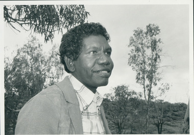
Photograph, Rev. Djiniyini Gondarra, 1986
... Development Northern Territory Government, 1995. ‘Where have All The Skilled People of Arnhem Land Gone – Economic Literacy’, Report Update for the Office of Aboriginal Development, June 1995. ‘Cross Cultural Awareness Education for Aboriginal People’, A consultancy for the Office of Aboriginal Development, 1994. ‘Let My People Go’, Series of Reflections of Aboriginal Theology, Bethel Presbytery 1986. ‘Working Together as Christians’, Nungalinya College T.E.E. Extension Study Book, with Rev. Don Carrington. ‘Overcoming the Captivities of the Western Church Context’, 8th Assembly Christian Conference of Asia, A Cultured Pearl: Australian...Development Northern Territory Government, 1995. ‘Where have All The Skilled People of Arnhem Land Gone – Economic Literacy’, Report Update for the Office of Aboriginal Development, June 1995. ‘Cross Cultural Awareness Education for Aboriginal People’, A consultancy for the Office of Aboriginal Development, 1994. ‘Let My People Go’, Series of Reflections of Aboriginal Theology, Bethel Presbytery 1986. ‘Working Together as Christians’, Nungalinya College T.E.E. Extension Study Book, with Rev. Don Carrington. ‘Overcoming the Captivities of the Western Church Context’, 8th Assembly Christian Conference of Asia, A Cultured Pearl: Australian ...Rev Dr Djiniyini Gondarra OAM, was born in Milingimbi, eastern Arnhemland in 1945. He was educated at Milingimbi Mission School and pursued his theological education as a youth leader and Sunday School teacher through the Methodist Church, before attending college in Brisbane. In 1969 he trained as a Minister in Papua New Guinea and the Solomon Islands under the Uniting Church, before returning to Arnhemland to minister his own people at the Galiwin’ku parish, firstly as a lay pastor (1971-1972) and then as a Minister from 1976-1982. In 1983-84, Rev Djiniyini worked as a Lecturer in Theology at Nungalinya College, Darwin. He was honoured with a Diploma of Theology (Honorary) from there in 1984, and in 1991 received a Cultural Doctorate in Literature (Honorary) from the World University, Roundtable, Arizona USA. Rev Djiniyini was awarded the Order of Australia Medal (OAM) in 1995. As well as being the Chairman of ALPA since 1993, Rev Djiniyini is currently the Director of Duduy’ngu Pty Ltd, which provides consultancy and cross-cultural services. He is also Director of Yirrkala Business Enterprises. Over the years, Rev Djiniyini has served on many committees and councils including: Member of the Steering Committee of the Australian Indigenous Cultural Network (1998-2001), CEO of Aboriginal Resource and Development Services Inc (1998-2001), CEO of the Northern Regional Council of the Uniting Aboriginal and Islander Christian Congress (1998-2001), Director of Reconciliation Australia Limited (2000-2001), Member of Council for Aboriginal Reconciliation (1998-2000), Chairman of Uniting Aboriginal and Islander Christian Congress (1995-2000 & 1990-1993), Member of Central Committee of the World Council of Churches (1991-1994), Moderator of Northern Synod, Uniting Church in Australia (1985-1987), Secretary of newly formed Aboriginal Presbytery, Northern Synod, Uniting Church in Australia (1985), and Vice-President of Uniting Aboriginal and Islander Christian Congress Uniting Church in Australia (1983-1987). Rev Dr Djiniyini Gondarra OAM has also been extensively published, and his works include: • Information Papers (co authored), Aboriginal Resource and Development Services: • Confusion Between Cultures (1998) • MHead & Shoulders of Djiniyini Gondarra facing right of picture."Rev. Djiniyini Gondarra 1986. Moderator Northern Synod and Vice President of Uniting Aboriginal and Islander Christian Conference."gondarra, djiniyini, uaicc, northern synod uca -
 Kew Historical Society Inc
Plan, Studley Heights Estate, 1936
... development. An obvious starting point for Sanderson’s groupings involved population growth and the associated economic cycles. These cycles also highlighted urban expansion onto land that was predominantly rural, although in other cases it represented the decline and breakup of large estates. A number of the plans in the Kew Historical Society’s collection can also be found in other collections, such as those of the State Library of Victoria and the Boroondara Library Service. A number are however unique to the collection. Subdivision plans are historically important documents used as evidence of the growth of suburbs in Australia ...Pru Sanderson, in her groundbreaking ‘City of Kew Urban Conservation Study : Volume 2 - Development History’ (1988), summarised the periods of urban development and subdivisions of land in Kew. The periods that she identified included 1845-1880, 1880-1893, 1893-1921, 1921-1933, 1933-1943, and Post-War Development. These periods were selected as they represented periods of rapid growth or decline in urban development. An obvious starting point for Sanderson’s groupings involved population growth and the associated economic cycles. These cycles also highlighted urban expansion onto land that was predominantly rural, although in other cases it represented the decline and breakup of large estates. A number of the plans in the Kew Historical Society’s collection can also be found in other collections, such as those of the State Library of Victoria and the Boroondara Library Service. A number are however unique to the collection.Subdivision plans are historically important documents used as evidence of the growth of suburbs in Australia. They frequently provide information about when the land was sold on which a built structure was subsequently constructed as well as evidence relating to surveyors and real estate and financial agents. The numerous subdivision plans in the Kew Historical Society's collection represent working documents, ranging from the initial sketches made in planning a subdivision to printed plans on which auctioneers or agents listed the prices for which individual lots were sold. In a number of cases, the reverse of a subdivision plan in the collection includes a photograph of a house that was also for sale by the agent. These photographs provide significant heritage information relating house design and decoration, fencing and household gardens.The ‘Studley Heights Estate’ on the South Side of Studley Park Road was launched in 1936. The seventeen allotments in the subdivision fronted Hyton Crescent and Studley Park Road.subdivision plans - kew, studley heights estate -
![Monnington [Estate], 1935](/media/collectors/550653872162f11fb04854aa/items/5907eb86d0ce0c14e82385c8/item-media/5907ecafd0ce0c14e823e87f/item-fit-380x285.jpg?cb=6) Kew Historical Society Inc
Kew Historical Society IncPlan - Subdivision Plan, Monnington [Estate], 1935, 1935
... development. An obvious starting point for Sanderson’s groupings involved population growth and the associated economic cycles. These cycles also highlighted urban expansion onto land that was predominantly rural, although in other cases it represented the decline and breakup of large estates. A number of the plans in the Kew Historical Society’s collection can also be found in other collections, such as those of the State Library of Victoria and the Boroondara Library Service. A number are however unique to the collection. Subdivision plans are historically important documents used as evidence of the growth of suburbs in Australia ...Pru Sanderson, in her groundbreaking ‘City of Kew Urban Conservation Study : Volume 2 - Development History’ (1988), summarised the periods of urban development and subdivisions of land in Kew. The periods that she identified included 1845-1880, 1880-1893, 1893-1921, 1921-1933, 1933-1943, and Post-War Development. These periods were selected as they represented periods of rapid growth or decline in urban development. An obvious starting point for Sanderson’s groupings involved population growth and the associated economic cycles. These cycles also highlighted urban expansion onto land that was predominantly rural, although in other cases it represented the decline and breakup of large estates. A number of the plans in the Kew Historical Society’s collection can also be found in other collections, such as those of the State Library of Victoria and the Boroondara Library Service. A number are however unique to the collection.Subdivision plans are historically important documents used as evidence of the growth of suburbs in Australia. They frequently provide information about when the land was sold on which a built structure was subsequently constructed as well as evidence relating to surveyors and real estate and financial agents. The numerous subdivision plans in the Kew Historical Society's collection represent working documents, ranging from the initial sketches made in planning a subdivision to printed plans on which auctioneers or agents listed the prices for which individual lots were sold. In a number of cases, the reverse of a subdivision plan in the collection includes a photograph of a house that was also for sale by the agent. These photographs provide significant heritage information relating house design and decoration, fencing and household gardens.The first subdivision of Monnington took place in 1935. At that time, Monnington and 10 new allotments were offered for sale bordering Adeney and Marshall Avenues. In this subdivision plan, Monnington is one of 13 lots for sale. The subdivision created the irregular land holding of Monnington today. The excision of southwest corner of Monninton was caused by the need to have regular allotments facing the curve in Marshall Avenue.monnington - adeney avenue -- kew (vic.), subdivision plans -- kew (vic.)