Showing 24 items matching "avoca district"
-
 Pyrenees Shire Council
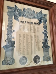
Record, Avoca and Lexton District WW1 Roll of Honour, c1914
... Avoca and Lexton District WW1 Roll of Honour...Avoca and Lexton District WW1 Roll of Honour ...Avoca and Lexton District WW1 Roll of Honour 1914 ...Pyrenees Shire Council 5 Lawrence Street Beaufort grampians Avoca and Lexton District WW1 Roll of Honour significant to the Pyrenees Shire and Lexton community Avoca and Lexton District WW1 Roll of Honour 1914 Avoca and Lexton District WW1 Roll of Honour Record ...Avoca and Lexton District WW1 Roll of Honour significant to the Pyrenees Shire and Lexton communityAvoca and Lexton District WW1 Roll of Honour 1914 -
 Marysville & District Historical Society
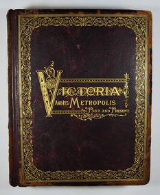
Book - Hardcover book, McCarron, Bird & Co, Victoria and its Metropolis-Past and Present-Volume 2, 1888
... ...avoca district...A history of the various colonies and districts of Victoria from the time of the discovery of Australia through until 1888. melbourne victoria pioneers colonisation history fauna flora banking finance medicine western district south-western district wimmera district geelong district ballarat district avoca district coliban district campase district loddon district lower goulburn district upper goulburn district ovens district north-east district gippsland district mornington district westernport district upper yarra district evelyn district bourke district A history of the various colonies and districts of Victoria from the time of the discovery of Australia through until 1888. ...A history of the various colonies and districts of Victoria from the time of the discovery of Australia through until 1888.Hardback. Dark brown cover with the title in gold lettering. There is also a border in gold decorating the outer edge of the front cover. The spine is also decorated in gold along with the title and the volume number.non-fictionA history of the various colonies and districts of Victoria from the time of the discovery of Australia through until 1888.melbourne, victoria, pioneers, colonisation, history, fauna, flora, banking, finance, medicine, western district, south-western district, wimmera district, geelong district, ballarat district, avoca district, coliban district, campase district, loddon district, lower goulburn district, upper goulburn district, ovens district, north-east district, gippsland district, mornington district, westernport district, upper yarra district, evelyn district, bourke district -
 Clunes Museum
Photograph - PHOTOGRAPHS - SLIDES
... SLIDES BEING FOUND IN THE COLLECTION OF AVOCA DISTRICT HISTORICAL SOCIETY...Clunes Museum 36 Fraser Street enter building through Collins Place Clunes goldfields SLIDES BEING FOUND IN THE COLLECTION OF AVOCA DISTRICT HISTORICAL SOCIETY CLUNS SLIDES A TOWN STUDY 44 SLIDES IN FOLDER AND PLASTIC SLEEVES, SLIDES ABOUT CLUNES SINCE 1839, LABELLED A TOWN STUDY WITH SOME NOTES Photograph PHOTOGRAPHS - SLIDES ...SLIDES BEING FOUND IN THE COLLECTION OF AVOCA DISTRICT HISTORICAL SOCIETY44 SLIDES IN FOLDER AND PLASTIC SLEEVES, SLIDES ABOUT CLUNES SINCE 1839, LABELLED A TOWN STUDY WITH SOME NOTEScluns slides, a town study -
 Stawell Historical Society Inc
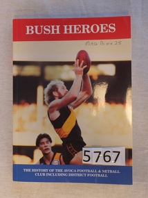
Book, Ross Dawson, Bush Heroes – The History of the Avoca Football & Netball Club including District Football, 1993
... Bush Heroes – The History of the Avoca Football & Netball Club including District Football...A Tribute to the Sportsmen & Sportswomen of the Avoca & District, on & off the field, Past & present. ...Stawell Historical Society Inc 46 Longfield St Stawell grampians A Tribute to the Sportsmen & Sportswomen of the Avoca & District, on & off the field, Past & present. stawell sport Bush Heroes The History of the Avoca Football & Netball library Card Cover with red strip across the top and Blue Strip across the Bottom, Color photograph of two men playing foorball Bush Heroes – The History of the Avoca Football & Netball Club including District Football Book Ross Dawson ...A Tribute to the Sportsmen & Sportswomen of the Avoca & District, on & off the field, Past & present. Card Cover with red strip across the top and Blue Strip across the Bottom, Color photograph of two men playing foorballBush Heroes The History of the Avoca Football & Netball librarystawell sport -
 Federation University Historical Collection
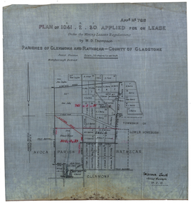
Plan, Plan applied for a Lease, Parishes of Glenmora and Rothcar, 27/05/1913
... avoca...maryborough district...glenmona rathcar gladstone maryborough mining clarence smith homebush clarence smith w d thompson peter leyden b elliot c horne a field john leydon g jolly r e jolly d garner s j barry m harris a harris w j mcconnell ellen harris r j harris j barry t curtain s garner e barry m j barry l e squires wilkins jnr e c grace e j field mary field m broughton b l lusby m j lusby j e field f broughton j gillock m simmons glenmona rathscar parish of avoca maryborough district albert field g grose j harris Plan on linen showing mining leases around the township of Lower Homebush, District of Maryborough. ...Plan on linen showing mining leases around the township of Lower Homebush, District of Maryborough. Scale: 20 chains to in inch (1:15840) WGS 84 Centroid Lat: 37 degrees 01 feet 35 inches S Long: 143 degrees 30 feet 35 inches S NS: 3.2km EW: 2.8km glenmona, rathcar, gladstone, maryborough, mining, clarence smith, homebush, clarence smith, w d thompson, peter leyden, b elliot, c horne, a field, john leydon, g jolly, r e jolly, d garner, s j barry, m harris, a harris, w j mcconnell, ellen harris, r j harris, j barry, t curtain, s garner, e barry, m j barry, l e squires, wilkins jnr, e c grace, e j field, mary field, m broughton, b l lusby, m j lusby, j e field, f broughton, j gillock, m simmons, glenmona, rathscar, parish of avoca, maryborough district, albert field, g grose, j harris -
 Victoria Police Museum
Police Stations (Amherst)
... In 1857 it came under the District of Avoca, in 1858 the District of Carisbrook, in 1859 the District of Avoca, in 1866 the District of Maryborough, in 1879 the South Western District, and Central District in 1883. ...In 1857 it came under the District of Avoca, in 1858 the District of Carisbrook, in 1859 the District of Avoca, in 1866 the District of Maryborough, in 1879 the South Western District, and Central District in 1883. ...Amherst, a former gold rush town, is located 13 kilometres south-west of Avoca on the Pyrenees Highway in the Pyrenees Shire in Victoria, Australia. It is 183 kilometres north west of Melbourne. The police station, in Camp Street, opened in 1853 and was originally in the District of Castlemaine. In 1857 it came under the District of Avoca, in 1858 the District of Carisbrook, in 1859 the District of Avoca, in 1866 the District of Maryborough, in 1879 the South Western District, and Central District in 1883. The station closed on 8 August 1892. In 1861 the station was staffed by 1 Mounted Constable, 1 Foot Senior Constable and 2 Foot Constables. Amherst "Outstation" opened in 1854 and was part of the Avoca District until it closed in 1856 An outstation was opened in 1854 and closed in 18561 photopolice stations; amherst police station -
 Maryborough Midlands Historical Society operating the Worsley Cottage Museum
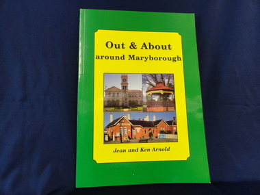
Book, Out and About around Maryborough, 2007
... Includes Carisbrook, Avoca, Dunolly districts. Soft covered book, 96 pages. ...Includes Carisbrook, Avoca, Dunolly districts. Soft covered book, 96 pages. ...Plaques and monuments incorporate vital information about Maryborough's history.Photographs of plaques and memorials around Maryborough, with captions. Includes Carisbrook, Avoca, Dunolly districts. Soft covered book, 96 pages. Cover features pictures of Maryborough Post Office and band rotunda and Talbot Post Office. Cover bordered in yellow and green.monuments plaques maryborough -
 Bendigo Historical Society Inc.
Document - THOMAS LANGDON COLLECTION: IN MEMORIAM FOLDER
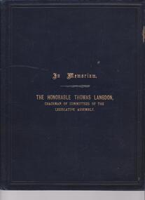
... The Honorable Thomas Langdon, Chairman of Committees of the Legislative Assembly' Inside, first page: In Memoriam, The Honorable Thomas Langdon, M.L.A., member of the Legislative Assembly for - The Avoca District from 1880 - 1889; The Korong District from 1892 - 1914. ...The Honorable Thomas Langdon, Chairman of Committees of the Legislative Assembly' Inside, first page: In Memoriam, The Honorable Thomas Langdon, M.L.A., member of the Legislative Assembly for - The Avoca District from 1880 - 1889; The Korong District from 1892 - 1914. ...Thomas Langdon (1832-1914) was born in Somerset, England and came to Australia in 1853. He started in Bendigo as a miner and carter before beginning farming at Laanacoorie. He married twice; Esther Temlett in 1855 and Sarah Coventry in 1862. He was elected to the Marong Shire Council in 1871 and went on to become a member of the Victorian parliament. He was the Member for Avoca and later Korong. In 1907 he was the Minister for Labour.Black leather folder, 5 pages inside. On front of folder in gold print ' In Memoriam. The Honorable Thomas Langdon, Chairman of Committees of the Legislative Assembly' Inside, first page: In Memoriam, The Honorable Thomas Langdon, M.L.A., member of the Legislative Assembly for - The Avoca District from 1880 - 1889; The Korong District from 1892 - 1914. Died 27th May, 1914. Following pages cite extracts from the minutes of the Lagislative Council that discuss Thomas Langdon's passion and significance in representing his constituents in Parliament. His passing is noted. 'Wednesday June 24 1914' The One. W.L. Baiullieu ' it is with much regret that I have to propose the following motion 'that this House desires to place on record its deep regret at the death of the Honorable Thomas Langdon .....'person, government, thomas langdon -
Federation University Historical Collection
Document, Zelda Martin, Central Victorian Goldmining towns - Boom Towns or Ghost Towns?, c1996
... In accordance with the Act the gold fields are divided into six districts - Ballaarat, Castlemaine , Sandhurst, Avoca, Ararat, and Beechworth.. ...In accordance with the Act the gold fields are divided into six districts - Ballaarat, Castlemaine , Sandhurst, Avoca, Ararat, and Beechworth.. ...Zelda Martin was a PhD candidate at the University of Melbourne.[.1] 4th item in light blue display book titled Research Approach/Overview of Chapters/Confirmation of Canditure/Chapters1,2,3&4 of proposed thesis. *Twenty-seven page article on Victorian goldfields towns titled: Central Victorian Goldmining Towns - Boom Towns or Ghost Towns. The article was written during the author's PhD study. It outlines the context methodology, and resources and the chapters of the proposed thesis: (1) Central Victorian Goldmining Towns - The Context (2) Contemporary Views of the Factors Necessary for Town Growth (3) Outward Manifestations of Town Growth (4) The Trappings of Government (5-9) The Main Towns and Their Hinterland. [.2] 5th item in Light Blue display book as above item. *Chapter 1 of proposed thesis titled 'Pick, Shovel and Tin Dish Mining.' Covers in Section A: Central Victoria - Pre 1851: Aborigines in Central Victoria, Squatters, and Government. Section B: The years 1851-1854: The Early Gold Rushes, Government Reaction, Township Surveys, Legislation, Town Development, Local Government and Early Settlement. [.3] 6th item in Light Blue display book as above item. *2A of proposed thesis titled 'Contemporary Views of the Factors Necessary for Town Growth'. Similar information to Chapter 1 plus extra re towns and maps. Sections: Introduction, Context of Place - Geographical Towns Listed, The Context of Time - Pre1851 Aborigines, Governance of Port Phillip, The Squatters, The Villages of Central Victorian Highlands, Conclusion, Condensed Version of Chapter2B. [.4] 7th item in Light Blue display book as above item. *Chapter2B of proposed thesis. Sections: Area of Research, Schools, Banks, Newspapers, Progress Association, Town Development - Sandhurst (Bendigo), Ballarat, Castlemaine,, Maryborough, Ararat and Stawell. [.5] 8th item in Light Blue display book as above item. *Chapter 3 of proposed thesis titled 'Outward Manifestations of Town Growth'. Sections: Introduction, Contemporary Writing, Educationalists, The Bankers, The Townsfolk, Current Theory, General Theories of Urban Development, and Conclusion. [.6] 9th item in Light Blue display book as above item. *Chapter 4 of proposed thesis titled 'Trappings of Government' Sections: Introduction, Early Government Attitudes to Mining and Town Development, Law and Order, Township Surveys, Legislation, Local Government, Transport and Communication, The People and Lobbyists. [.7] 10th item in Light Blue display book as above item. *'The Rise and Fall of Central Victorian Goldmining Towns'. Includes a map showing main Goldfields, a table showing towns and villages at two points in time - 1857 and 1871; a Bibliography of Primary and Secondary Sources. [.8] Resource No1. Black display book titled Local Towns 1 : Alma: *Brief history *Directory *Maps Amphitheatre / Mountain Hut: *Brief History Post Office Directory Ararat: *Brief History *Post Office Directory 1869 - Alphabetical Listing by Occupation *Ararat - Prominent Citizens of 1858 *Langi-Morgala Museum Avoca: *Brief History *Excerpts from 'Avoca The Early Years', Margery and Betty Beavis; pg1 - Beginnings; pg11 - The Midas Touch; pg25 - Local Gold Escorts; pg27 - A Town is Born; pg51- The Administration of Justice; pg53 - The Ways of the Law; pg61 - News of the Day; pg65 - A Time to Play; pg72 - Land Ownership *Post Office Directory (Bailliere's) 1869 *Tourism Map and Information of area *Historic Avoca - A 5.5km Tour *Avoca & the Pyrenees Region - information pamphlet Ballarat: *Early History of Ballarat - Ballarat Historical Society, Publication No.1: origin of the name; Ballaarat - the Beginning; Fabulous Yields from the Ballaarat Goldfield; *Streetscape Lydiard Street. *Hand drawn map showing Leigh River, Old Portland Bay Road, plaque on road to Colac; etc. *Newspaper article re 'The Theatre Royal' ( which stood in the vicinity of the current Owen Williams store) - 'The News'15/04/1998 *Article - 'Ballarat's Mechanics' Institute Lives On' Ballarat Courier, 14/09/1985 *Article - Standing the Test of Time' The News 17/11/1993 re The Mechanics Institute & picture of the Reading Room *'Ballarat a Study of a City, Phyllis Reichl, pub. Nelson, 1968; no.3 place, time and people field studies series *Investigator Vol.33 No.2, 1998 Geelong Historical Society. Article on pg75 describes Ballarat in 1861 *Folded poster - 'Ballarat 100' a history of telegraph communication, pub. Telecom. Beaufort (Fiery Creek): *Brief history *Post Office Directory [.9] Resource No.2 Black Folder Titled Towns cont.No2 Bendigo (Sandhurst): *'Family & Local History at the Bendigo Library - 1851-2001 150 years of gold'. *Bendigo Government Camp in 1853 illustration; key to sketch and names of Government officers stationed there *Excerpts from 'Bendigo and Vicinity' Adolph Haman *The Bendigo Goldfield Registry - pgs 1-7 Introduction *Excerpt: 'Breaking the Grip' *Excerpt: The Most Go-Ahead Place *Excerpts from 'History of Bendigo' - anti license agitation; laying out of town; proposed railway; gold calls and dividends; the Sandhurst Municipality; journalism *Bibliography Blackwood: *Excerpts from 'Aspects of Early Blackwood - The Goldfield, the Landmarks, the Pioneers' Alan J Buckingham and Margaret F Hitchcock, JG Publishing,1980 Buninyong: *A Brief History *Investigator Vol1 No.2 Feb 1966 Geelong Historical Society. Pg3 - Article re gold escort route - Mt Alexander to Adelaide - (see a simple monument on the Western Highway a few miles out of Horsham. Pg 15 - Ballarat Excursion - re the finding of gold. *Three articles published by Buninyong and District Historical Society Inc: (Magpie Exploration; Finding Gold In The Green Hills; Magpie Exploration; Burnt Bridge to Cargarie to Mt Mercer) *Copies of newspaper articles/items *Buninyong Street Directory Carisbrook: *In the Beginning There Was Carisbrook *The History of the Carisbrook Racecourse Carngham / Snake Valley: *Brief History *Directory Castlemaine: *Directory 1865-1866 - Alphabetical and Street *Poster - Castlemaine A Contemporary Guide "The Great Centre" 1866 - A Contemporary Guide to the Fascinating Past *Pamphlet - Castlemaine District Community Hospital *Map - Castlemaine, Maldon & Surrounding Districts *Map and Information - The Dry Diggings Track - a 55kl walk among historic goldfields relics ( Castlemaine Fryerstown Vaughan Mt Franklin Hepburn Daylesford) *Postcard - Former Court House *Directory 1867 - Alphabetical, Trade [.10] Resource No.3 Grey folder Titled Towns 3 Creswick to Maryborough Creswick: *Brief History *Booklet - "Creswick Cemetery Walk" *Booklet - The Buried Rivers of Gold Heritage Trail Creswick *Creswick Historical Museum Information Sheet *Chronological History of Creswick *Alphabetical Directory of the Borough of Creswick *Creswick's Creek Directory 1856 *Historic Creswick Walking Tour *A Brief Account of the Schools of Creswick - Past and Present *100 Years of Railway Travel in Creswick *The Berry Deep Leads *The Spence Home at Jackass Gully in the Creswick State Forest ( William Guthrie Spence - Pioneer) *The New Australian Mine and the 1882 Disaster *Creswick District News, Issue 7, July August 1999 *The Creswick Miners Walk - Information and Map *Maps Chewton: *Brief History *Directory Clunes: *Brief History *Clunes Street Directory Daylesford: *Brief History *Notable Bushfires in Daylesford District Over More Than a Century - "Black Thursday" 1851; 1862; 1899; the Disastrous Hepburn Fire of 1906; 1939; 1944; 1969. *Post Office Directory -Daylesford and Hepburn Dunolly / Inkerman: *Brief History *Directory *Pamphlet - Goldfields Historical Museum *Pamphlet - Historic Dunolly - Victoria's Best Kept Secret *Map of Gold Workings at Dunolly Area - showing where the main gold rushes occurred *Brief History - Inglewood *Directory - Inglewood - Name Occupation, Dwelling Kingower: *Brief History *Directory - Name / Ocupation / Dwelling Linton / Happy Valley / Piggoreet: *Brief History *Directory - Lintons McIvor: *"A History of the Shire and the Township of Heathcote" by J.O. Randell Majorca: *Brief History *Official Post Office Directory 1869 - Name / Occupation/ Address Maldon (Tarrangower): *Brief History Part 1 *Brief History Part 2 *Post Office Directory *List - Alphabetical Order by Names plus Business and Trade (Tarrangower Times Oct/1858) *List - Alphabetical Order by Trade plus Name and Business *Directory - Name / Occupation / Dwelling Maryborough: *Worsley Cottage - built by Arthur Worsley, a contractor in stonework in 1894 [.11] Resource No. 4 Blue Display Book titled Towns 4 Moliagul to Stawell Moliagul: *Brief History *Moligul Legislative Assembly (Voting?) List - Names and Occupations *Moliagul Victorian Post Office Directory 1868 - Name / Ocupation / Address / Comments *"The Welcome Stranger" gold nugget *The Sunday School *The Welcome Stranger Discovery Walk - information and map Moonambel (Mountain Creek) Redbank *Brief History *List of names extracted from advertisments of the Pioneer and Mountain Creek Advertiser 16/02/1861. *Bailliere's Directory 1869 - Alphabetical List of Name / Occupation / Place St Arnaud: *Brief History Sebastapol: *Brief History *Directory 1869 - Alphabetical by Name; plus occupation and address. Browns and Scarsdale: *Brief History *Browns Street Directory - Name and Occupation Smythesdale: *Brief Description *Smythesdale Street Directory -Name and Occupation Stawell (Pleasant Creek) *Brief History *Victorian Official Post Office Directory - Name /Occupation / Dwelling *Chronology - 1841-1920 *Production of gold statistics - 1879 - 1900 *Big Hill *Extracts from "The Golden Years of Stawell". Chapt 1 - Stawell's Coming Out. Capt. 2 - The Gold Rush. Caapt.3 - Cradle of Democracy. Chapt.4 - The Reefs Becomes Stawell. Chapt. 5 - Rushing In. Chapt.6 - The Pioneers. Chapt 7 - The Decade of Optimism. [.12] Resource No. 5: Blue Display Book titled 'Towns Steiglitz to the The Golden Triangle. Steiglitz: Brief History Victorian Post Office Directory 1869 *Map of Steiglitz *List of maps relevant to Steiglitz history *Information 6 tables of data from "Reports of Mining Surveyors Talbot (Back Creek) Brief History Taradale: Post office Directory 1869 - Name/Occupation/Street. Also list in alphabetical order by Occupation Taradale *Chronological Reference to Taradale Mines *Water - The Coliban System of Waterworks *Joseph Brady *The Syphon Tarnagulla (Sandy Creek) *Brief History *Tarnagulla Businessmen Cameos to give depth to advertisments in 'The Tarnagulla Courier' various issues 1864-1871 *Directory - Name/Occupation /Address *List - Name/Business/Trade Wedderburn (Koorong) *Brief History *List - Name/Occupation The Golden Triangle: *The Early Rushes - Wedderburn / Moliagul / Sandy Creek - Tarnagulla / Jones Creek - Waanyarra / Kingower / Dunolly - Goldsborough / Inglweood *Census of 1857 - Population / Occupations *1858-1871 - A Time of Consolidation- Wedderburn / Moliagul / Sandy Creek- Tarnagulla / Arnold *Census 1871 - Population *Information gleaned from the census data - Demographics / Population / Occupations / marital / Birthplace / Religion / Literacy/ Occupation and Housing Cameos *Graphs - Birthplace of settlers /Male-Female Ratio / Married males / Children under 15 as Percentage of Population / Religion *Census 1857 - Statistical data *Maps *Bibliography [.13] Resource No. 6 - Black Display Book Information and Research in Central Victoria including: *Banking - Research from ANZ Bank Archives *Institutions - also includes articles listed from the Ballarat Times Newspaper *Australian mining History Association - A.M.H.A. Bibliography *Australia's Mining History * Bibliography - Land Surveys Victoria - *1853 Administration (Statistics and Other) includes: schools / ministers of religion / police / military / local administration / licences for sale of spirits / distances between various Victorian gold fields. * Victoria Government Gazette (Copy) - N0. 116, 12/12/1854 includes: Gold Felds Commission of Enquiry & No. 85, 15/09/1854 - Addresses presented to the Lieutenant Governor (Sir Charles Hotham) during his tour through the Gold Fields of Victoria,1854. Addresses on behalf of : the people of Bendigo; Members of the Church of England, Bendigo; Members of the Wesleyan Church on the Bendigo Gold Fields; Bendigo Gold District General Hospital; the Bendigo Prospecting Association; Committee of the Bendigo Local Exhibition; Bendigo District Medical Association; Coloured Americans Resident at Bendigo; German Inhabitants of Bendigo; Landowners, Inhabitants, and Miners of Castlemaine; Inhabitants of Forest Creek; Inhabitants of Heathcote and Gold Miners of McIvor; Residents and landholders of the District of Bacchus Marsh; Inhabitants of Kilmore and Vicinity. *Gold Fields Correspondence 1853: letter from Lieutenant Colonel Valiant, (Officer commanding the Troops in Victoria) to the Lieutenant Governor re threatened disturbance at Sandhurst (Bendigo) regarding the Gold License Fee. * Extracts from a book "Victoria" re Gold Fields Commission of Enquiry involving mainly Ballarat and Castlemaine and a chapter titled 'A Tour to the Victorian Gold-Fields' *Lists of central Victorian newspapers - listed by date published 1851to 1874; by first date available to State Library. *A list of cities and towns showing County, population in 1861 &1871, and municipal status. [.14] Resource no.7. Black display book. *Reference: Papers presented to Parliament Victoria - 1859-1860 4 volumes - relevant sections copied. Contains information on Branches of Government. General / Finance / Gold / Gazette / Commission and Warrant / Statistic. *Gold Fields Act. In accordance with the Act the gold fields are divided into six districts - Ballaarat, Castlemaine , Sandhurst, Avoca, Ararat, and Beechworth.. Official staff in each gold district consists of a Resident Warden, Wardens, Wardens' Clerks, Bailiffs, Chinese Protectors, Chinese Interpreters, and Mining Surveyors. *Gold Receiver *Gaols *Police magistrates and Clerks of Petty Sessions, etc. *Field Branch *Immigration and Emigration Overland - Chinese - 1859 *Population on the Goldfields *The Geological Survey - The Government Geologist is assisited by staff from four branches - the office Branch; the Publishing Branch; the Field Branch and the Museum Branch. *Commission to Enquire Into Sludge dated 10/02/1859 (Some sections copied) - Report to the Honorable Chief Commissioner of Public Works, Melbourne re the mode of carrying the sludge from the puddling mills in Sandhurst without interfering with the drainage of the town and the roads in the neighbourhood. [.15] Resource No.8: Camel display book titled Resource No. 8. Aborigines *Lists of book titles - +"Readings in Victorian prehistory" +"The Aborigines of Port Phillip" +Aboriginal languages and clans" +"A History of the Port Phillip District" +"Langi Ghiran 1: Aboriginal Rock...." +"Koorie History: sources for aboriginal studies in the State Library of Victoria", ed. Tom Griffiths, Melb. Friends of the State Library, 1989 +"The Public Lands of Australia Felix"; settlement and land appraisal in Victoria1834-91 with special reference to the Western Plains", J.M.Powell, Melb. Oxford University Press 1970 +*Bibliography of the Victorian Aborigines' from the earliest manuscripts to 31st December 1970, Massoa, Aldo, Melb. Hawthorn Press, 1971 +"Aborigines in Colonial Victoria, 1836-1886", M.F. Christie, Sydney University Press, 1979 +"Urban and Industrial Australia: readings in Human Geography" ed J.M. Powell, Melb. Sorrett Pub. 1974 *Extracts: -Processes of Pioneer Settlement - The Squatting Occupation of Victoria, 1834-60. J.M. Powell -Areal Variations in the Class Structure of the Central-Place Hierarchy. P. Scott - Volume1 and Volume 2: Notes Relating to the Habits of the Natives of Other Parts of Australia and Tasmania. Compiled from various sources for the Government of Victoria by R Brough Smyth. John Curry, O'Neil, Melb. 1st pub. Melb. 1876. p31-45 - Numbers and Distribution of the Aborigines in Victoria -Victorian Aborigines 1835-1901 - A Resource Guide to the Holdings of the Public Record Office, Victoria; published by the Government Information Centre 1984. *History of the Aboriginal Artefacts Displayed in the Daylesford Museum. F. G. Powell (4 page pamphlet) *Letter to Zelda Martin from Peter Lovett, Cultural Officer, Ballarat & District Aboriginal Co- Operative, 05/02/1997 *Map: Ian Clarke Victorian Tribunal Boundary Map - Clans of Central Victoria. *Victorian Rock Art and Mythology - Article about Mount Langhi Ghiran and myths of the Tjapwarong people. *Two Aboriginal myths relating to the Grampians - 'The Monster Emu' / 'The Aquisition of Fire', by the Aborigines in the Grampians Areas *Article titled (chapter 8) Ballarat - information re camping sites in the region. Lake Wendouree / Lake Burrumbeet (includes a myth) / Mt Bunninyong / Lal Lal / Pitfield / Mount Elephant / Mount Egerton / Meredith / Lake Goldsmith / Lake Learmonth / Ercildoune *Notes on the Aborigines of the Wider Ballarat Region plus European names=Aboriginal names. John Morris 26/07/1995 *Role of Aborigines in Town Development in Central Victoria. Mentions Native Police Force est. in Port Phillip 1842 and Central Board for Aborigines est. 1860 *The Grave of King Billy. (Frank Wilson) Pamphlet. *Camping Places in Central and Northern Victoria. Article re Lake Burrumbeet site. *Programme for the Unveiling of Memorial Cairn for Edward Stone Parker 1802-1865. Note portrait not accurate. Accurate portrait is available in the book "A Successful Failure A Trilogy The Aborigines and Early Settlers", Edgar Morrison, Graffiti Publications, 2002. * Large envelope addressed to Mr G Netherway containing newspaper cuttings regarding the life of Edward Stone Parker, the unveiling of the Memorial Cairn as mentioned above, articles titled 'Episodes from Our Early Days' (Edgar Morrison, Yandoit)- The Black's School, A School At Last and The Final years. Also a typed page titled 'Historical Background to E.S.Parker's Career. Includes an interesting tale titled 'When the cat lay doggo' re laying power leads for the unveiling ceremony at the memorial site. [.16] green display folder titled 'Research Aids' *List of references to Commissioners' & W'ardens' Reports (formerly held at La Trobe Library Archives, now at Public Records Office [PRO]). Indicates town referred to / date of report / name of camp if different to town. * Archive information re Anglican Records *Movement around the Goldfields - Miners and Storekeepers - usefulness of newspapers in providing information - areas covered - Castlemaine, Maldon, Ararat, Stawell, Tarnagulla, Dunolly. *Port Phillip /Victoria Directories 1839/1867 - Chronological list of Directories included in this series. *"Notes on the History of Local Government in Victoria" A.W. Greig Melb. University Press 1925 - Photo-copied extract p5-p40. (Source - Deakin University Library) - Introduction by W.Harrison Moore. Section 1 - Development in New South Wales Before Separation. Section 2 - Development in Victoria After Its Separation from New South Wales. Hand written notations: 'roads, markets, and local government 1855 on' ;'opportunity of squatters in parliament' and 'opportunities of matters in parliament p33' * Notes on the Establishment of Surveyor General's Department 1851and Commissioner of Crown Lands and Survey. * Newspaper articles from The Argus, 1849, re the discovery of gold in the Pyrenees region. * Excerpt - a report on schools - A.B.Orlebar, Inspector; re the need for permanent school buildings rather than tents. *Excerpt from - 'Approaches to Urban History', Sean Glynn: The Case for Caution * Except from - 'The Urban Sprinkle', Weston Bate: Country Towns and Australian Regional History *Reference- 'The History of Land Tenure in the Colony of Victoria', John Quick. References the Haines Land Bill, land tenure and Land Leagues. [.17] Light blue envelope folder titled 'Birtchnell's Ballarat, etc. Directory 1862 *Contains various directories for Smythesdale, Buninyong, Clunes, Brown's and Creswick. [.18] Red envelope folder no.2 titled Victorian Gazetteer *Selected pages from 1869 Victorian Gazetteer on A4 paper (with a handwritten note questioning if some pages are from 1868 Victorian Gazetteer as appears to be different sizes - A3 pages.) Information includes locations and descriptions of towns, hotels, banks, communications and populations. (Does not include names, residences and occupations) [.19] Red Envelope folder titled Bailliere's Official Post Office Directory 1868 (or1869 or a mixture of both?) *Preface *Contains a selection of pages of towns highlighted in yellow in the the index *Work on this directory was commenced in 1867. *Information includes: Municipalities - mayors and councilors; lists of towns naming male inhabitants and their occupations. [.20]Yellow manila folder titled Post Grad Seminar Presentation 1996 *Gives some background to Zelda Martin's proposed thesis and why she chose the topic Gold Mining Towns Boom or Bust [.21] A3 display book - No. 1A * A list of 'Relevant Newspapers collected: The Tarrangower Times and Maldon Advertiser (first published 1858) Includes dates 1858-1867. The Mount Alexander Mail. Includes dates 1854-1866 The Tarnagulla Courier. Includes dates from1864-1871 Dunolly and Burnt Creek Express. Includes dates from 1862-1871 * Selection of newspaper pages from The Mount Alexander Mail 1854 to 1856, mostly showing advertisements for businesses and services provided to that community. [.22] A3 display book - No. 1B * Selection of newspaper pages from The Mount Alexander Mail 1857 to 1866, mostly showing advertisements for businesses and services provided to that community. [.23] A3 display book -No. 2 * Selection of newspaper pages from The Tarnagulla Courier 1864 to 1871, mostly showing advertisements for businesses and services provided to that community. [.24] A3 display book - No. 3 *Selection of newspaper pages from The Tarrangower Times (and Maldon and Newstead) Advertiser 1858 to1867, mostly showing advertisements for businesses and services provided to that community. [.25] A3 display book - No.4 * Selection of newspaper pages from The Dunolly and Burnt Creek Express; and The Dunolly and Betbetshire Express 1862 to 1871, mostly showing advertisements for businesses and services provided for that community. [.26] A3 display book - No.5 Includes: * Bryce Ross's Diggings Directory. Includes instructions for using this directory. This directory was used by "all persons having connexion or desiring to communicate with 'working parties, private friends, or Stores at the Diggings." As a directory for each area wwas completed it was published in each month's issue of Bonwick's "Digger's Magazine." Years c1852/1853. This Directory commences first at the head of Forest Creek. Includes a directory for Bendigo and Ballarat. Of interest at the end of the Bendigo and Ballarat directory is a list of the number of storekeepers, butchers, doctors, smiths, eating houses, lemonade sellers and chapels. * The Castlemaine Directory and Book of General Information Comprehending Glass's Model Calendar for the Two Years 1862 and1863. "zelda martin, victorian goldfield towns, bendigo, castlemaine, ballarat, maldon, stawell, ararat, maryborough, creswick, avoca, heathcote, banks, bank of australasia, union bank of australia, government camp, sandhurst, water supply, tarnagulla, talbot, back creek, mountain creek, police court, carisbrook, dunolly, thompson's foundry, charles clacy, anthony trollope, robert cecil, mount alexander, urbanisation, national schools, education, govenrment, industry, railway, transport, settlement, land settlement in central victoria, steiglitz, joseph brady, the new australian mine, berry deep leads, william guthrie spence, creswick state forest, arthur worsley, worsley cottage, the welcome stranger, moliagul, moonambel, redbank, st arnaud, sebastapol, brown's, scarsdale, clunes, chewton, daylesford, bushfires, inkerman, inglewood, kingower, lintons, happy valley, piggoreet, mcivor, majorca, tarrangower, taradale, the coliban system, the syphon, sandy creek, wedderburn, koorong, arnold, jones creek, waanyarra, the golden triangle, census 1857, blackwood, buninyong, durham lead, magpie, carngham, snake valley, alma, amherst, daisy hill, amphitheatre, mountain hut, beaufort, fiery creek, counties, population, gold fields commission of enquiry1854, william westgarth, gold license fee, lieutenant colonel valiant, administration of the victorian gold fields, commission to enquire into sludge 1859, e.s. parker, edward stone parker, edgar morrison, mount franklin protectorate, dja dja wurrung, memorial cairn, franklinford, mt franklin memorial cairn, jajowurrong, dja dja wurung, tjaowarong, wothowurong, assistant protectors, daylesford museum, buluk, rock art - grampians, aboriginal mythology - grampians, aborigines, first nations people, mount franklin, aboriginal artifacts, lake burrumbeet, native police force, central board of aborigines, yandoit, commissioners' reports, wardens' reports, port phillip/victoria directories 1839-1867, local government - victoria 1853/1854, surveyor general's department - 1850's, victorian schools 1850's, a.b.orlebar, haines land bill, william charles haines, wilson gray, land tenure, land leagues, victorian gazetteer, the tarrangower times and maldon advertiser - 1858-1867, the mount alexander mail 1854-1866, the tarnagulla courier 1864, dunolly and burnt creek express 1862-1871, bryce rose's diggings directory, the castlemaine directory 1862-1863 -
 Wycheproof & District Historical Society Inc.
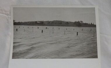
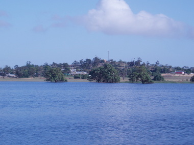
Photograph, Mr Ernie Taylor, Cooroopajerrup Creek 1923, 1923 (exact)
... Wycheproof & District Historical Society Inc. 38 High Street Wycheproof the-murray The semi-mythical stream, the Cooroopajerrup Creek. Before there were any channel banks and formed roads, this creek shared the Avoca flood waters with the Tyrrell Creek. ...The semi-mythical stream, the Cooroopajerrup Creek. Before there were any channel banks and formed roads, this creek shared the Avoca flood waters with the Tyrrell Creek. In more recent times the Wycheproof channel prevented the major floods of 1956 and 1973 from following the old river course. Also there is said to have been some shifting of the sand-hills at Teddywaddy which have blocked much of the old Cooroopajerrup flow. Little is known of earlier records, but The Mount Wycheproof Ensign records flooding of the creek in 1909. 2011 saw the Cooroopajerrup flow again after 88 years. This 2011 photo was taken at about the same position as the 1923 photo. The modern steel roadway fence is submerged. see-Photograph-Record No 001997.Copy of a B&W photograph of the Cooroopajerrup-Creek in flood-1923. To the north is Mount-Wycheproof, with the hospital barely visible behind the trees just left of centre, and a few scattered dwellings. The nearer railway-fence follows the road leading to the current saleyards.The outer fence has been replaced with a modern steel fence.None1923, cooroopajerrup creek, flood, mount wycheproof -
 Wycheproof & District Historical Society Inc.
Photograph, Len Storey, Cooroopajerrup Creek 2011, 17/1/2011 (exact)
... Wycheproof & District Historical Society Inc. 38 High Street Wycheproof the-murray On Monday January 17th 2011,Wycheproof residents awoke to see the township surrounded by water. Record flooding on the Avoca ...On Monday January 17th 2011,Wycheproof residents awoke to see the township surrounded by water. Record flooding on the Avoca River had forced the flood water up the semi-mythical Cooroopajerrup Creek. Digital colour photograph of the Cooroorajerrup Creek, depicting the flood-waters of 2011 surrounding Mount Wycheproof. The dwelling in the foreground is the home of Francis and Denise Dillon, barely visible to the left is the Public Hospital.cooroopajerrup creek, mount wycheproof, 2011, flood waters -
 Eltham District Historical Society Inc
Photograph, Four guests at Buffet Dinner. Left: Mr. Higgins Methodist Minister, Eltham, Mrs. Higgins and Captain Brian Robertson and Captain Irene Robertson of the Salvation Army, 7 Jul 1971
... District Historical Society Inc 728 Main Rd Eltham melbourne Guests at the West Riding Hall, Henry Petrie Community Centre, Montmorency on the occasion of a buffet dinner as part of the Shire of Eltham centenary celebrations. Left: Mr Higgins, Methodist Minister, Eltham and Mrs Higgins and Brian & Irene Robertson, both Captains in the Salvation Army. Reverend William ‘Bill’ Leslie Higgins (b. 15/1/1925, Renmark, Victoria, d. 18/10/1998) and Mrs Ella May Higgins (née Leersen b. 3/11/1921, Avoca ...Guests at the West Riding Hall, Henry Petrie Community Centre, Montmorency on the occasion of a buffet dinner as part of the Shire of Eltham centenary celebrations. Left: Mr Higgins, Methodist Minister, Eltham and Mrs Higgins and Brian & Irene Robertson, both Captains in the Salvation Army. Reverend William ‘Bill’ Leslie Higgins (b. 15/1/1925, Renmark, Victoria, d. 18/10/1998) and Mrs Ella May Higgins (née Leersen b. 3/11/1921, Avoca, Victoria, d. 24/5/2003). William was ordained to the Methodist Church of Australia on September 1, 1959. Bill and Ella were involved with many communities throughout Bill’s full-time service until 1989. These parishes included Underbool, Wycheproof, Drysdale, Wonthaggi, South Yarra, Eltham, Nathalia, Murchison and Seymour. Bill and Ella touched many thousands lives during their ministry. Bill passed away in 1998 while assisting with a Sunday evening service near Drysdale, and Ella continued to dedicate her time to others until her death in 2003. Information received via Brian and Irene Robertson's son, Mark (15 Dec 2023), noted that in 1969 they lived in Prahran and by 1971 they would have been appointed to Briar Hill (now Greensborough). Brian Robertson's parents and at least one set of his grandparents were also Salvation Army officers (primarily from Victoria), whilst Irene was originally from Perth and she had 2 other sisters that became Salvation Army Officers as well. Irene also had 3rd sister and younger brother who were linked to the Salvos (as was Brian’s brother). After several years in church work, Brian and Irene transferred over to the Social Services branch of the Salvos and worked with homeless men, broken families, drug & alcohol dependent clients (similar to what Brendan Nottle does in Burke St), family stores and eventually seniors (nursing homes). Brian, known as Robbie passed away in 2013, and Irene is currently living in a retirement unit. [Dedc 2023]This photo forms part of a collection of photographs gathered by the Shire of Eltham for their centenary project book, "Pioneers and Painters: 100 years of the Shire of Eltham" by Alan Marshall (1971). The collection of over 500 images is held in partnership between Eltham District Historical Society and Yarra Plenty Regional Library (Eltham Library) and is now formally known as 'The Shire of Eltham Pioneers Photograph Collection.' It is significant in being the first community sourced collection representing the places and people of the Shire's first one hundred years.Digital imagesepp, shire of eltham pioneers photograph collection, shire of eltham, shire of eltham centenary, henry petrie community centre, centenary celebrations, buffet dinner, higgins, rev. william (bill) higgins, ella may higgins (nee leersen), salvation army, brian robertson, irene robertson -
 Charlton Golden Grains Museum Inc
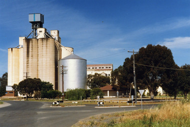
Photograph, Charlton Shire, Charlton Flour Mill, c.1987
... Avoca River and was acquired in 1919 by Noske Bros. The present Flour Mill was built by Noske Bros and opened in May 1927. It was taken over by the Grain Elevator Board in the 1970s. Noske's Flour Mill, with its commanding presence and towering silos, has long **dominated the Charlton skyline** and remains a significant landmark, even though it no longer mills flour. The mill's history is deeply intertwined with the development of Charlton and the grain industry of the surrounding district...Avoca River and was acquired in 1919 by Noske Bros. The present Flour Mill was built by Noske Bros and opened in May 1927. It was taken over by the Grain Elevator Board in the 1970s. Noske's Flour Mill, with its commanding presence and towering silos, has long **dominated the Charlton skyline** and remains a significant landmark, even though it no longer mills flour. The mill's history is deeply intertwined with the development of Charlton and the grain industry of the surrounding district ...A previous mill had operated in Charlton by Mr. W.E. Foreman on the banks of the Avoca River and was acquired in 1919 by Noske Bros. The present Flour Mill was built by Noske Bros and opened in May 1927. It was taken over by the Grain Elevator Board in the 1970s. Noske's Flour Mill, with its commanding presence and towering silos, has long **dominated the Charlton skyline** and remains a significant landmark, even though it no longer mills flour. The mill's history is deeply intertwined with the development of Charlton and the grain industry of the surrounding district. The foundation for the mill's presence was laid in 1919 when Messrs Noske Bros. Pty. Ltd., already owning mills in Horsham, Nhill, and Murray Bridge, acquired G. H. Foreman’s Mill located by the Avoca River. The founder, **T. J. Noske**, was an early pioneer of flour exporting, expanding his milling business after unexpectedly acquiring the Horsham mill. ### A State-of-the-Art Operation The original mill by the river operated until August 1926 before being closed and dismantled. Plans were well underway for a **new, state-of-the-art mill** to be located at the former Cobb and Co site. In 1927, the new mill began operation. It was one of the largest in the state, boasting a capacity of three tons of flour per hour, a 250 h.p. diesel engine, and three initial silos. The mill quickly gained a reputation for **excellence** for both its design and its flour, which was sold successfully in local and overseas markets. ### Periods of Expansion and Trial The mill continued to grow, reflecting the importance of the local agricultural industry. Between 1940 and 1941, **nine new silos** were built, adding bulk receival points. In the record-breaking 1968 season, the mill received a colossal wheat intake of **695,000 bushels**. However, the mill also faced setbacks. On January 21, 1949, disaster struck when a **large fire** erupted in the storage shed, which contained 500 tons of bagged flour ready for export and new flour bags. The blaze was so intense that smoke was visible as far away as Wycheproof, and it threatened to destroy the entire mill. Thanks to the monumental efforts of the Charlton, St. Arnaud, Wycheproof, and Wedderburn Brigades, who ran the main pump almost continuously for 26 hours, the damage was contained, though the estimated loss was a substantial £60,000. ### Transformation of the Site At its peak, the mill was a major employer, providing work for approximately 65–70 men. But after over 45 years of operation, flour production at the mill ceased on October 25, 1973. Noske Industries Ltd. sought to adapt, converting the operation to a less successful stock feed production centre. In 1977, the **Grain Elevators Board** took over the site as a grain receival depot, building a large elevator tower that surpassed the height of the original buildings. The site eventually returned to private hands and, since 2000, has been owned and operated as a primary grain receival site for **GrainCorp**, cementing its continued, vital role in Charlton's agricultural life. Colour photograph of Charlton Flour Mill and silos. Intersection of Kaye & Davies Streets in the foreground. One large silver silo and three taller greyish concrete silos to the left. Three other cream coloured silos behind. There are pipes and sheds on top of the silos. There is a cream single story building to the right of the silver silo and a multi-storey building behind with eight window in the upper level. There is a small red brick building on the far left of the photo.w.e. foreman, noske bros, flour mill charlton, business, industry -
 Charlton Golden Grains Museum Inc
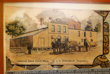
Photograph - Lithograph, Rider & Mercer, Views of Charlton
... Avoca river. The mill owners attempted to dam the river during the 1870s. The mill was built in 1876 as recorded by the local traveling correspondent . Foreman's flour mill established 1876 at the west end of High Street. Sold to Norske in 1925. Replaced by Noske's Flour Mill on Kays Street in 1927. Noske's Flour Mill, with its commanding presence and towering silos, has long **dominated the Charlton skyline** and remains a significant landmark, even though it no longer mills flour. The mill's history is deeply intertwined with the development of Charlton and the grain industry of the surrounding district...Avoca river. The mill owners attempted to dam the river during the 1870s. The mill was built in 1876 as recorded by the local traveling correspondent . Foreman's flour mill established 1876 at the west end of High Street. Sold to Norske in 1925. Replaced by Noske's Flour Mill on Kays Street in 1927. Noske's Flour Mill, with its commanding presence and towering silos, has long **dominated the Charlton skyline** and remains a significant landmark, even though it no longer mills flour. The mill's history is deeply intertwined with the development of Charlton and the grain industry of the surrounding district ...Close up photograph of part of the Charlton Lithograph showing the Charlton Steam Power Flour Mill of G & C Foreman. Located in on the bank of the Avoca river. The mill owners attempted to dam the river during the 1870s. The mill was built in 1876 as recorded by the local traveling correspondent . Foreman's flour mill established 1876 at the west end of High Street. Sold to Norske in 1925. Replaced by Noske's Flour Mill on Kays Street in 1927. Noske's Flour Mill, with its commanding presence and towering silos, has long **dominated the Charlton skyline** and remains a significant landmark, even though it no longer mills flour. The mill's history is deeply intertwined with the development of Charlton and the grain industry of the surrounding district. The foundation for the mill's presence was laid in 1919 when Messrs Noske Bros. Pty. Ltd., already owning mills in Horsham, Nhill, and Murray Bridge, acquired G. H. Foreman’s Mill located by the Avoca River. The founder, **T. J. Noske**, was an early pioneer of flour exporting, expanding his milling business after unexpectedly acquiring the Horsham mill. ### A State-of-the-Art Operation The original mill by the river operated until August 1926 before being closed and dismantled. Plans were well underway for a **new, state-of-the-art mill** to be located at the former Cobb and Co site. In 1927, the new mill began operation. It was one of the largest in the state, boasting a capacity of three tons of flour per hour, a 250 h.p. diesel engine, and three initial silos. The mill quickly gained a reputation for **excellence** for both its design and its flour, which was sold successfully in local and overseas markets. ### Periods of Expansion and Trial The mill continued to grow, reflecting the importance of the local agricultural industry. Between 1940 and 1941, **nine new silos** were built, adding bulk receival points. In the record-breaking 1968 season, the mill received a colossal wheat intake of **695,000 bushels**. However, the mill also faced setbacks. On January 21, 1949, disaster struck when a **large fire** erupted in the storage shed, which contained 500 tons of bagged flour ready for export and new flour bags. The blaze was so intense that smoke was visible as far away as Wycheproof, and it threatened to destroy the entire mill. Thanks to the monumental efforts of the Charlton, St. Arnaud, Wycheproof, and Wedderburn Brigades, who ran the main pump almost continuously for 26 hours, the damage was contained, though the estimated loss was a substantial £60,000. ### Transformation of the Site At its peak, the mill was a major employer, providing work for approximately 65–70 men. But after over 45 years of operation, flour production at the mill ceased on October 25, 1973. Noske Industries Ltd. sought to adapt, converting the operation to a less successful stock feed production centre. In 1977, the **Grain Elevators Board** took over the site as a grain receival depot, building a large elevator tower that surpassed the height of the original buildings. The site eventually returned to private hands and, since 2000, has been owned and operated as a primary grain receival site for **GrainCorp**, cementing its continued, vital role in Charlton's agricultural life.Colour photo taken of a small portion of the Charlton Lithograph. Showing the Charlton Steam Flour Mill of G. C. Foreman.Charlton Steam Flour Mills. G & C Foreman proprietors.lithograph, business, industry, charlton, flour mill, noske bros, foreman -
 Charlton Golden Grains Museum Inc
Photograph, c.1948
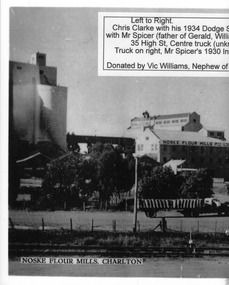
... district. The foundation for the mill's presence was laid in 1919 when Messrs Noske Bros. Pty. Ltd., already owning mills in Horsham, Nhill, and Murray Bridge, acquired G. H. Foreman’s Mill located by the Avoca...district. The foundation for the mill's presence was laid in 1919 when Messrs Noske Bros. Pty. Ltd., already owning mills in Horsham, Nhill, and Murray Bridge, acquired G. H. Foreman’s Mill located by the Avoca ...Black and white photo copied and enlarged from small photo which was part of a set produced in c.1948. Chris Clarke with his 1934 Dodge semi trailer and W Spicer in his 1930 International truck line up to unload wheat at Noske's mill. Noskes flour mill built in 1927 with extra silos added in 1940's.Photo enlarged by Vic Williams of Bendigo nephew of Chris Clarke transport driver. Noske's Flour Mill, with its commanding presence and towering silos, has long **dominated the Charlton skyline** and remains a significant landmark, even though it no longer mills flour. The mill's history is deeply intertwined with the development of Charlton and the grain industry of the surrounding district. The foundation for the mill's presence was laid in 1919 when Messrs Noske Bros. Pty. Ltd., already owning mills in Horsham, Nhill, and Murray Bridge, acquired G. H. Foreman’s Mill located by the Avoca River. The founder, **T. J. Noske**, was an early pioneer of flour exporting, expanding his milling business after unexpectedly acquiring the Horsham mill. ### A State-of-the-Art Operation The original mill by the river operated until August 1926 before being closed and dismantled. Plans were well underway for a **new, state-of-the-art mill** to be located at the former Cobb and Co site. In 1927, the new mill began operation. It was one of the largest in the state, boasting a capacity of three tons of flour per hour, a 250 h.p. diesel engine, and three initial silos. The mill quickly gained a reputation for **excellence** for both its design and its flour, which was sold successfully in local and overseas markets. ### Periods of Expansion and Trial The mill continued to grow, reflecting the importance of the local agricultural industry. Between 1940 and 1941, **nine new silos** were built, adding bulk receival points. In the record-breaking 1968 season, the mill received a colossal wheat intake of **695,000 bushels**. However, the mill also faced setbacks. On January 21, 1949, disaster struck when a **large fire** erupted in the storage shed, which contained 500 tons of bagged flour ready for export and new flour bags. The blaze was so intense that smoke was visible as far away as Wycheproof, and it threatened to destroy the entire mill. Thanks to the monumental efforts of the Charlton, St. Arnaud, Wycheproof, and Wedderburn Brigades, who ran the main pump almost continuously for 26 hours, the damage was contained, though the estimated loss was a substantial £60,000. ### Transformation of the Site At its peak, the mill was a major employer, providing work for approximately 65–70 men. But after over 45 years of operation, flour production at the mill ceased on October 25, 1973. Noske Industries Ltd. sought to adapt, converting the operation to a less successful stock feed production centre. In 1977, the **Grain Elevators Board** took over the site as a grain receival depot, building a large elevator tower that surpassed the height of the original buildings. The site eventually returned to private hands and, since 2000, has been owned and operated as a primary grain receival site for **GrainCorp**, cementing its continued, vital role in Charlton's agricultural life.Black and white photo copied and enlarged from small photo.charlton, flour mill, noske's, noske bros -
 Charlton Golden Grains Museum Inc
Photograph, c.1948
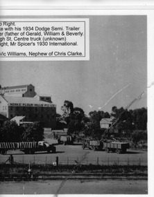
... district. The foundation for the mill's presence was laid in 1919 when Messrs Noske Bros. Pty. Ltd., already owning mills in Horsham, Nhill, and Murray Bridge, acquired G. H. Foreman’s Mill located by the Avoca...district. The foundation for the mill's presence was laid in 1919 when Messrs Noske Bros. Pty. Ltd., already owning mills in Horsham, Nhill, and Murray Bridge, acquired G. H. Foreman’s Mill located by the Avoca ...Black and white photo copied and enlarged from small photo which was part of a set produced in c.1948. Chris Clarke with his 1934 Dodge semi trailer and W Spicer in his 1930 International truck line up to unload wheat at Noske's mill. Noskes flour mill built in 1927 with extra silos added in 1940's. Photo enlarged by Vic Williams of Bendigo nephew of Chris Clarke transport driver. Noske's Flour Mill, with its commanding presence and towering silos, has long **dominated the Charlton skyline** and remains a significant landmark, even though it no longer mills flour. The mill's history is deeply intertwined with the development of Charlton and the grain industry of the surrounding district. The foundation for the mill's presence was laid in 1919 when Messrs Noske Bros. Pty. Ltd., already owning mills in Horsham, Nhill, and Murray Bridge, acquired G. H. Foreman’s Mill located by the Avoca River. The founder, **T. J. Noske**, was an early pioneer of flour exporting, expanding his milling business after unexpectedly acquiring the Horsham mill. ### A State-of-the-Art Operation The original mill by the river operated until August 1926 before being closed and dismantled. Plans were well underway for a **new, state-of-the-art mill** to be located at the former Cobb and Co site. In 1927, the new mill began operation. It was one of the largest in the state, boasting a capacity of three tons of flour per hour, a 250 h.p. diesel engine, and three initial silos. The mill quickly gained a reputation for **excellence** for both its design and its flour, which was sold successfully in local and overseas markets. ### Periods of Expansion and Trial The mill continued to grow, reflecting the importance of the local agricultural industry. Between 1940 and 1941, **nine new silos** were built, adding bulk receival points. In the record-breaking 1968 season, the mill received a colossal wheat intake of **695,000 bushels**. However, the mill also faced setbacks. On January 21, 1949, disaster struck when a **large fire** erupted in the storage shed, which contained 500 tons of bagged flour ready for export and new flour bags. The blaze was so intense that smoke was visible as far away as Wycheproof, and it threatened to destroy the entire mill. Thanks to the monumental efforts of the Charlton, St. Arnaud, Wycheproof, and Wedderburn Brigades, who ran the main pump almost continuously for 26 hours, the damage was contained, though the estimated loss was a substantial £60,000. ### Transformation of the Site At its peak, the mill was a major employer, providing work for approximately 65–70 men. But after over 45 years of operation, flour production at the mill ceased on October 25, 1973. Noske Industries Ltd. sought to adapt, converting the operation to a less successful stock feed production centre. In 1977, the **Grain Elevators Board** took over the site as a grain receival depot, building a large elevator tower that surpassed the height of the original buildings. The site eventually returned to private hands and, since 2000, has been owned and operated as a primary grain receival site for **GrainCorp**, cementing its continued, vital role in Charlton's agricultural life.Black and white photocharton, business, noske bros, flour mill -
 Charlton Golden Grains Museum Inc
Photograph, c.1960
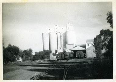
... district. The foundation for the mill's presence was laid in 1919 when Messrs Noske Bros. Pty. Ltd., already owning mills in Horsham, Nhill, and Murray Bridge, acquired G. H. Foreman’s Mill located by the Avoca...district. The foundation for the mill's presence was laid in 1919 when Messrs Noske Bros. Pty. Ltd., already owning mills in Horsham, Nhill, and Murray Bridge, acquired G. H. Foreman’s Mill located by the Avoca ...Noske's mill in mid 1960s. Noske's Flour Mill, with its commanding presence and towering silos, has long **dominated the Charlton skyline** and remains a significant landmark, even though it no longer mills flour. The mill's history is deeply intertwined with the development of Charlton and the grain industry of the surrounding district. The foundation for the mill's presence was laid in 1919 when Messrs Noske Bros. Pty. Ltd., already owning mills in Horsham, Nhill, and Murray Bridge, acquired G. H. Foreman’s Mill located by the Avoca River. The founder, **T. J. Noske**, was an early pioneer of flour exporting, expanding his milling business after unexpectedly acquiring the Horsham mill. ### A State-of-the-Art Operation The original mill by the river operated until August 1926 before being closed and dismantled. Plans were well underway for a **new, state-of-the-art mill** to be located at the former Cobb and Co site. In 1927, the new mill began operation. It was one of the largest in the state, boasting a capacity of three tons of flour per hour, a 250 h.p. diesel engine, and three initial silos. The mill quickly gained a reputation for **excellence** for both its design and its flour, which was sold successfully in local and overseas markets. ### Periods of Expansion and Trial The mill continued to grow, reflecting the importance of the local agricultural industry. Between 1940 and 1941, **nine new silos** were built, adding bulk receival points. In the record-breaking 1968 season, the mill received a colossal wheat intake of **695,000 bushels**. However, the mill also faced setbacks. On January 21, 1949, disaster struck when a **large fire** erupted in the storage shed, which contained 500 tons of bagged flour ready for export and new flour bags. The blaze was so intense that smoke was visible as far away as Wycheproof, and it threatened to destroy the entire mill. Thanks to the monumental efforts of the Charlton, St. Arnaud, Wycheproof, and Wedderburn Brigades, who ran the main pump almost continuously for 26 hours, the damage was contained, though the estimated loss was a substantial £60,000. ### Transformation of the Site At its peak, the mill was a major employer, providing work for approximately 65–70 men. But after over 45 years of operation, flour production at the mill ceased on October 25, 1973. Noske Industries Ltd. sought to adapt, converting the operation to a less successful stock feed production centre. In 1977, the **Grain Elevators Board** took over the site as a grain receival depot, building a large elevator tower that surpassed the height of the original buildings. The site eventually returned to private hands and, since 2000, has been owned and operated as a primary grain receival site for **GrainCorp**, cementing its continued, vital role in Charlton's agricultural life.Black and white photograph with white border.charlton, business, noske's, flour mill -
 Charlton Golden Grains Museum Inc
Postcard, A view of Charlton. The seasons greeting from Charlton, c.1946
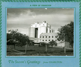
... district. The foundation for the mill's presence was laid in 1919 when Messrs Noske Bros. Pty. Ltd., already owning mills in Horsham, Nhill, and Murray Bridge, acquired G. H. Foreman’s Mill located by the Avoca...district. The foundation for the mill's presence was laid in 1919 when Messrs Noske Bros. Pty. Ltd., already owning mills in Horsham, Nhill, and Murray Bridge, acquired G. H. Foreman’s Mill located by the Avoca ...Eight silos added in 1940s. Noske's Flour Mill, with its commanding presence and towering silos, has long **dominated the Charlton skyline** and remains a significant landmark, even though it no longer mills flour. The mill's history is deeply intertwined with the development of Charlton and the grain industry of the surrounding district. The foundation for the mill's presence was laid in 1919 when Messrs Noske Bros. Pty. Ltd., already owning mills in Horsham, Nhill, and Murray Bridge, acquired G. H. Foreman’s Mill located by the Avoca River. The founder, **T. J. Noske**, was an early pioneer of flour exporting, expanding his milling business after unexpectedly acquiring the Horsham mill. ### A State-of-the-Art Operation The original mill by the river operated until August 1926 before being closed and dismantled. Plans were well underway for a **new, state-of-the-art mill** to be located at the former Cobb and Co site. In 1927, the new mill began operation. It was one of the largest in the state, boasting a capacity of three tons of flour per hour, a 250 h.p. diesel engine, and three initial silos. The mill quickly gained a reputation for **excellence** for both its design and its flour, which was sold successfully in local and overseas markets. ### Periods of Expansion and Trial The mill continued to grow, reflecting the importance of the local agricultural industry. Between 1940 and 1941, **nine new silos** were built, adding bulk receival points. In the record-breaking 1968 season, the mill received a colossal wheat intake of **695,000 bushels**. However, the mill also faced setbacks. On January 21, 1949, disaster struck when a **large fire** erupted in the storage shed, which contained 500 tons of bagged flour ready for export and new flour bags. The blaze was so intense that smoke was visible as far away as Wycheproof, and it threatened to destroy the entire mill. Thanks to the monumental efforts of the Charlton, St. Arnaud, Wycheproof, and Wedderburn Brigades, who ran the main pump almost continuously for 26 hours, the damage was contained, though the estimated loss was a substantial £60,000. ### Transformation of the Site At its peak, the mill was a major employer, providing work for approximately 65–70 men. But after over 45 years of operation, flour production at the mill ceased on October 25, 1973. Noske Industries Ltd. sought to adapt, converting the operation to a less successful stock feed production centre. In 1977, the **Grain Elevators Board** took over the site as a grain receival depot, building a large elevator tower that surpassed the height of the original buildings. The site eventually returned to private hands and, since 2000, has been owned and operated as a primary grain receival site for **GrainCorp**, cementing its continued, vital role in Charlton's agricultural life.Large landscape black and white photo set on a blue card backing. The card has a green holly leaf pattern embossed on the edge.A view of Charlton. The Season's Greetings from Charlton.charlton, noske bros, noske's, flour mill -
 Bendigo Historical Society Inc.
Slide - DIGGERS & MINING. THE GOLD LICENCE, c1854
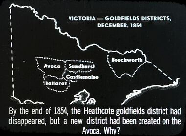
... Beechworth, Sandhurst Avoca, Castlemaine and Ballarat. By the end of 1854, the Heathcote goldfields district had disappeared, but a district had been created on the Avoca. ...Beechworth, Sandhurst Avoca, Castlemaine and Ballarat. By the end of 1854, the Heathcote goldfields district had disappeared, but a district had been created on the Avoca. ...Diggers & Mining. The gold licence. The Government Camp. Slide depicts map of Victoria with the 5 gold rush regions marked on it. Beechworth, Sandhurst Avoca, Castlemaine and Ballarat. By the end of 1854, the Heathcote goldfields district had disappeared, but a district had been created on the Avoca. Why? Markings: 31 994.LIF. 4. Used as a teaching aid.hanimounteducation, tertiary, goldfields -
 Bendigo Historical Society Inc.
Document - LANDS OFFICE, REPORTS OF SALES BY PUBLIC AUCTION BENDIGO DISTRICT
... district. Entries are in chronological order of sales with sale advertisement attached to page. Includes Manangatang, Boort, Rushworth, Maldon, Heathcote, Castlemaine, Sea Lake, Avoca....district. Entries are in chronological order of sales with sale advertisement attached to page. Includes Manangatang, Boort, Rushworth, Maldon, Heathcote, Castlemaine, Sea Lake, Avoca. ...Document: green hard cover book with buff spine and corners. Contains details of public auctions of land in Bendigo and district. Entries are in chronological order of sales with sale advertisement attached to page. Includes Manangatang, Boort, Rushworth, Maldon, Heathcote, Castlemaine, Sea Lake, Avoca.Lands Officeland sales, northern victoria, lands office, land surveyed, land sold, public auction, country victoria -
 Federation University Historical Collection
Map, Creswick, Clunes, Smeaton, Newstead, Yandoit and District, 1904, 06/1904
... Barker Library (top floor) Mount Helen goldfields ascot creswick clunes franklinford miners rest sandon smeaton tourello yandoit mt moorookyle powlett's hill woodhouse's hill smeaton hill mcdonald's hill green hill spring hill horse shoe hill mt cameron strangways avoca forest stanley hunter j.w. gregory d. mcleod donald mcleod daruel A coloured geological map with green and pink predominating. The shows Ascot, Creswick, Clunes, Franklinford, Miners Rest, Sandon, Smeaton, Tourello, Yandoit Creswick, Clunes, Smeaton, Newstead, Yandoit and District, 1904 Map Map Stanley Hunter ...A coloured geological map with green and pink predominating. The shows Ascot, Creswick, Clunes, Franklinford, Miners Rest, Sandon, Smeaton, Tourello, Yandoitascot, creswick, clunes, franklinford, miners rest, sandon, smeaton, tourello, yandoit, mt moorookyle, powlett's hill, woodhouse's hill, smeaton hill, mcdonald's hill, green hill, spring hill, horse shoe hill, mt cameron, strangways, avoca forest, stanley hunter, j.w. gregory, d. mcleod, donald mcleod, daruel -
 Federation University Historical Collection
Document - Real Estate Flyers, J. Chatham, Daunt Pty. Ltd, Various years
... district...the mill restaurant malmsbury..."emu downs" beaufort..."wattlw grove" mount mercer..."rowan lodge"...centennial hotel kensington..."ben nevis estate" elmhurst..."paddlesteamer lodge" wodonga place albury..."woodlands" ararat...lake wallace hotel, edenhope...cremorne hotel newtown geelong...terang hotel...avoca...[Jane Dyer (nee Chatham).16 June 2024] j chatham daunt auction "greenslopes" haddon "mindai park" cape clear kingston district the mill restaurant malmsbury "emu downs" beaufort "wattlw grove" mount mercer "rowan lodge" centennial hotel kensington "ben nevis estate" elmhurst "paddlesteamer lodge" wodonga place albury "woodlands" ararat lake wallace hotel, edenhope cremorne hotel newtown geelong terang hotel avoca hotel woori yallock hotel ballarat tram family restaurant victoria hotel woodend patersons siding restaurant and bar, ballarat the coorrabin motor inn, stawell clifton hill hotel, clifton hill albion hotel, kyabram "stag hotel" learmonth "osborne" rokewood shamrock hotel echuca willaura hotel, willaura "boggy creek pub" curdie vale shamrock hotel, dennington "mt elephant hotel/motel" derrinallum narmbool, ballarat brighton inn hotel khyat's posters real estate Hotels. ...The Ballarat-based firm, J Chatham and Co, serviced the Hotel Industry in Victoria, particularly Victoria’s Wimmera and Western Districts. Established by Jack { John} Chatham in 1956, The business was based at 7 Lydiard St South, Ballarat. As a regional hotel and motel broking specialist, Jack worked closely with other Ballarat businesses, including the Ballarat Brewery. On Jack's death in 1967, the business was taken over by his son, Philip, and renamed J Chatham Pty Ltd. The business continued to grow. Chatham House, the building the business operated from, and subsequently purchased and named, at 7 Lydiard St South, Ballarat still stands today. It was renamed by new owners in 2025 In the 1970's Philip opened a Melbourne branch in Dudley St, Nth Melbourne, The Melbourne branch, J Chatham and Daunt Pty Ltd, operated from 205 Victoria Parade, Fitzroy, a few blocks west of the Carlton United Brewery in the 1980s. In the late 1980s Philip's son, Andrew, joined the business, then called J Chatham, Daunt and Foley Pty Ltd. The business at this time operated from a terrace house [?Bouverie Street] Carlton near Grattan St. By 2005, the Daunt and Foley partnership had dissolved. In 2001 Philip predeceased his wife, Elizabeth Chatham (nee Holmes), a Director of the Company. His share of the business was inherited by Andrew. Elizabeth died in 2005. The business was sold in 2006. [Jane Dyer (nee Chatham).16 June 2024]Thirty-one real estate flyers j chatham, daunt, auction, "greenslopes" haddon, "mindai park" cape clear, kingston district, the mill restaurant malmsbury, "emu downs" beaufort, "wattlw grove" mount mercer, "rowan lodge", centennial hotel kensington, "ben nevis estate" elmhurst, "paddlesteamer lodge" wodonga place albury, "woodlands" ararat, lake wallace hotel, edenhope, cremorne hotel newtown geelong, terang hotel, avoca hotel, woori yallock hotel, ballarat tram family restaurant, victoria hotel woodend, patersons siding restaurant and bar, ballarat, the coorrabin motor inn, stawell, clifton hill hotel, clifton hill, albion hotel, kyabram, "stag hotel" learmonth, "osborne" rokewood, shamrock hotel echuca, willaura hotel, willaura, "boggy creek pub" curdie vale, shamrock hotel, dennington, "mt elephant hotel/motel" derrinallum, narmbool, ballarat, brighton inn hotel, khyat's, posters, real estate, hotels., restaurants -
 Narre Warren and District Family History Group
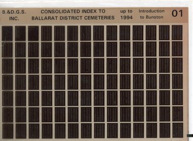
Film, Ballarat and District Genealogical Society Inc, Consolidated Index to Ballarat District Cemeteries Up to 1994, c1995
... Narre Warren and District Family History Group 110 High Street Berwick melbourne Cemeteries -- Victoria -- Ballarat Ballarat (Vic.) The index contains information for: Amhurst Cemetery; Avoca Cemetery; Ballan Cemetery; Beaufort Cemetery; Bungaree Cemetery; Buninyong Cemetery; Cape Clear Cemetery; Carngham Cemetery; Clarendon Cemetery; Clunes Cemetery; Coghills Creek Cemetery; Creswick Cemetery; Daylesford Cemetery; Dowling Forest Cemetery; Eganstown/Blanket Flat Cemetery; Eurenbeen East/Franklinford Cemetery; Gordon Cemetery; Greendale Cemetery; Learmonth Cemetery; Lexton Cemetery; Linton Cemetery; Majorca Cemetery; Maryborough Cemetery; Morrisons Cemetery; Mt Cole Cemetery; Mt Egerton Cemetery; Mt Prospect Cemetery; Newstead Cemetery; Rokewood Cemetery; Skipton Cemetery; Smeaton Cemetery; Smeaton House Cemetery; Smythesdale Cemetery; Staffordshire Reef Cemetery; Talbot Cemetery; Waterloo Cemetery and Waubra Cemetery. ...The index contains information for: Amhurst Cemetery; Avoca Cemetery; Ballan Cemetery; Beaufort Cemetery; Bungaree Cemetery; Buninyong Cemetery; Cape Clear Cemetery; Carngham Cemetery; Clarendon Cemetery; Clunes Cemetery; Coghills Creek Cemetery; Creswick Cemetery; Daylesford Cemetery; Dowling Forest Cemetery; Eganstown/Blanket Flat Cemetery; Eurenbeen East/Franklinford Cemetery; Gordon Cemetery; Greendale Cemetery; Learmonth Cemetery; Lexton Cemetery; Linton Cemetery; Majorca Cemetery; Maryborough Cemetery; Morrisons Cemetery; Mt Cole Cemetery; Mt Egerton Cemetery; Mt Prospect Cemetery; Newstead Cemetery; Rokewood Cemetery; Skipton Cemetery; Smeaton Cemetery; Smeaton House Cemetery; Smythesdale Cemetery; Staffordshire Reef Cemetery; Talbot Cemetery; Waterloo Cemetery and Waubra Cemetery.Set of 10 microfiche. non-fictionThe index contains information for: Amhurst Cemetery; Avoca Cemetery; Ballan Cemetery; Beaufort Cemetery; Bungaree Cemetery; Buninyong Cemetery; Cape Clear Cemetery; Carngham Cemetery; Clarendon Cemetery; Clunes Cemetery; Coghills Creek Cemetery; Creswick Cemetery; Daylesford Cemetery; Dowling Forest Cemetery; Eganstown/Blanket Flat Cemetery; Eurenbeen East/Franklinford Cemetery; Gordon Cemetery; Greendale Cemetery; Learmonth Cemetery; Lexton Cemetery; Linton Cemetery; Majorca Cemetery; Maryborough Cemetery; Morrisons Cemetery; Mt Cole Cemetery; Mt Egerton Cemetery; Mt Prospect Cemetery; Newstead Cemetery; Rokewood Cemetery; Skipton Cemetery; Smeaton Cemetery; Smeaton House Cemetery; Smythesdale Cemetery; Staffordshire Reef Cemetery; Talbot Cemetery; Waterloo Cemetery and Waubra Cemetery. cemeteries -- victoria -- ballarat, ballarat (vic.) -
Pyrenees Shire Council
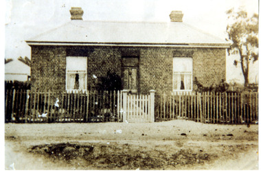
photograph, Avoca in 1866 by J.N. Dallimore, 1866
... Dalimore lived at Woodstock Station, near Avoca, he exhibited view photographs of the district at the 1866 Melbourne Intercolonial Exhibition that were sent on to the 1867 Paris Universal Exhibition. ...Dalimore lived at Woodstock Station, near Avoca, he exhibited view photographs of the district at the 1866 Melbourne Intercolonial Exhibition that were sent on to the 1867 Paris Universal Exhibition. ...J.N. Dalimore was an amateur photographer and settler who arrived at Port Phillip (Victoria) with his wife in September 1840 on board the Himalaya. Dalimore lived at Woodstock Station, near Avoca, he exhibited view photographs of the district at the 1866 Melbourne Intercolonial Exhibition that were sent on to the 1867 Paris Universal Exhibition. The Avoca Mail of 7 November 1866 reported: Mr Dallimore of Woodstock, determined that the town of Avoca and its environs shall be pictorially represented at the Victorian and Paris Exhibitions, has we learn, forwarded a series of photographs representing the High Street and the Pyrenees [Victoria] from different points of view. All the photographs are well executed and will possess considerable interest for the friends of Avocaites visiting the World’s Fair in 1867. Also included were views of Dallimore’s own station. They won him a medal 'for good Landscape Photography’. His panoramic photograph of Avoca is in the Shire Council significant as a historic photograph of Avoca, locally significant to the Central Highlands Region of Victoria as a representation of local landscape and/or culture Black and white photograph of Avoca showing Rutherford Street to the left and the original site of the Avoca Hotel"verso (affixed): AVOCA MAIL, 1st JUNE 1867. ""A remarkably well-executed photograph of the town of Avoca taken in 1866. and forming one of the exhibits at the Melbourne Exhibition, has been presented to the Avoca Shire Councilby F.W. Dalimore formally of Woodstock verso (affixed): No. 875 Intercolonial Exhibition 1866 Exhibitor: Avoca Shire Council Class: Section:"