Showing 620 items matching "bacchus"
-
 Bacchus Marsh & District Historical Society
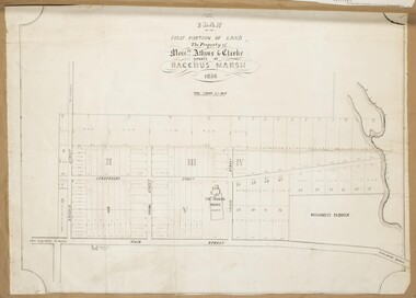
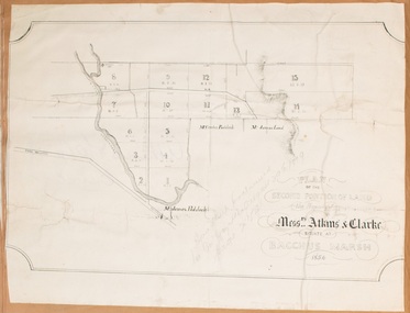
Map, Atkins and Clarke Land Sale situate at Bacchus Marsh 1856 Copy 2
... Atkins and Clarke Land Sale situate at Bacchus Marsh 1856 Copy 2...The Bacchus family sold their property in Bacchus Marsh to John Atkins and Robert Nalder Clarke in March 1851. ...A single page paper map showing a portions of land available for sale in Bacchus Marsh in 1856. The subdivided land shown was owned by John Atkins and Robert Nalder Clarke, but previously owned by the Bacchus Family and was in and around their Manor House (Mansion) property in Bacchus Marsh.There are 5 portions of land further divided into numerous small portions. ...The property of Messers Atkins and Clarke situate at Bacchus Marsh....Shire of Bacchus Marsh...Bacchus Marsh & District Historical Society Lerderderg Library Main Street Bacchus Marsh This plan of land allotments for sale indicates the property once owned by the Bacchus family in and around the township area of Bacchus Marsh. ...This plan of land allotments for sale indicates the property once owned by the Bacchus family in and around the township area of Bacchus Marsh. The Bacchus family sold their property in Bacchus Marsh to John Atkins and Robert Nalder Clarke in March 1851. Atkins and Clarke kept the property for a number of years until April 1856 when these allotments were put up for sale.This plan is almost identical to another copy held by the Bacchus Marsh and District Historical Society, VC Record 707, BMDHS collection). This plan, VC Record 452 Copy 2, contains a less detail than than VC Record 707 Copy 1. For example the selling agents and the surveyor who created the plan are not indicated on this copy of the plan. This copy of the plan does indicate the name Crook Street on the map. As the Crook family were the buyers of the Manor House property and surrounding land from Atkins and Clarke in 1856 it suggests that this copy is a later one of the earlier version. It is unlikely that the Crook family would have had the adjacent street named after them prior to purchasing the house and property. This is a very early land sales plan for the township of Bacchus Marsh and it therefore provides some clues as to how the early urban development of the township took place. Upon seeing the map in 1911 Bacchus Marsh Express newspaper editor Christopher Crisp wrote "The sale appears to have created the present township, which had a nucleus in earlier times further east", Express, 30 September, 1911, page 3. A single page paper map showing a portions of land available for sale in Bacchus Marsh in 1856. The subdivided land shown was owned by John Atkins and Robert Nalder Clarke, but previously owned by the Bacchus Family and was in and around their Manor House (Mansion) property in Bacchus Marsh.There are 5 portions of land further divided into numerous small portions. The land for sale is bounded by the present day streets of Main Street, Young Street, McFarland Street, Morton Streets, Crook Street, and part of the eastern section extends to the Lerderderg River. Scale: 4 chains to 1 inch. The map is pasted into a bound volume containing 76 maps or plans in total. High resolution digital image stored on BMDHS computer network. Plan of the first portion of land. The property of Messers Atkins and Clarke situate at Bacchus Marsh.land sales, land sales bacchus marsh, manor house bacchus marsh, crook family bacchus marsh -
 Bacchus Marsh & District Historical Society
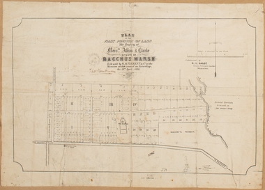
Map, Plan of the property of Messers Atkins and Clarke to be sold at the Mansion, Bacchus Marsh 19th April 1856. Copy 1
... Plan of the property of Messers Atkins and Clarke to be sold at the Mansion, Bacchus Marsh 19th April 1856. Copy 1...The Bacchus family sold their property in Bacchus Marsh to John Atkins and Robert Nalder Clarke in March 1851. ...BMDHS Loc: AR/B12/S4 Bacchus Marsh Township and Nearby Districts Maps Volume In-house Digital copies: BMDHS, Computer Network: Maps\Bacchus Marsh Township and Nearby Districts Maps Volume...Post Office Stamp: BACCHUS MARSH VICTORIA MY 6, 63...Shire of Bacchus Marsh...Bacchus Marsh & District Historical Society Lerderderg Library Main Street Bacchus Marsh This plan of land allotments for sale indicates the property once owned by the Bacchus family in and around the township area of Bacchus Marsh. ...This plan of land allotments for sale indicates the property once owned by the Bacchus family in and around the township area of Bacchus Marsh. The Bacchus family sold their property in Bacchus Marsh to John Atkins and Robert Nalder Clarke in March 1851. Atkins and Clarke kept the property for a number of years until April 1856 when these allotments were put up for sale.This plan is almost identical to another copy held by the Bacchus Marsh and District Historical Society, VC Record 452, BMDHS collection). This plan, VC Record 707 Copy 1, contains a little more detail overall than VC Record 452 Copy 2, such as who did the survey work for the plan (R.C. Bagot) and who the selling agents were, (W.M. Tennent), and on the right side of the plan near the Lerderderg River is indicated the general area for a second parcel of land from this sale which is to be sold. There is also a compass illustration indicating north and south compass points.This is a very early land sales plan for the township of Bacchus Marsh and it therefore provides some clues as to how the early urban development of the township took place. Upon seeing the map in 1911 Bacchus Marsh Express newspaper editor Christopher Crisp wrote "The sale appears to have created the present township, which had a nucleus in earlier times further east", Express, 30 September, 1911, page 3.A single page paper plan showing allotments of land for sale. The subdivided land shown was owned by John Atkins and Robert Nalder Clarke, but previously owned by the Bacchus Family and was in and around their Manor House (Mansion) property in Bacchus Marsh.There are 5 portions of land further divided into numerous small portions. The land for sale is bounded by the present day streets of Main Street, Young Street, McFarland Street, Morton Streets, Crook Street, and part of the eastern section extends to the Lerderderg River. Scale: 8 chains to 1 inch The plan is pasted into a bound volume containing 76 maps or plans in total. BMDHS Loc: AR/B12/S4 Bacchus Marsh Township and Nearby Districts Maps Volume In-house Digital copies: BMDHS, Computer Network: Maps\Bacchus Marsh Township and Nearby Districts Maps VolumeHeading: Plan of the first portion of land. The property of Messers Atkins and Clarke situate at Bacchus Marsh. To be sold by W.M. Tennent & Co. at the Mansion on the Ground on Saturday the 19th April 1856. Below heading: Jas Ferguson, Lithographer On upper right side: Subdivided by R.C. Bagot London and Liverpool Chambers, Melbourne. 'Thos Taubman'. Post Office Stamp: BACCHUS MARSH VICTORIA MY 6, 63bacchus marsh victoria maps, bacchus family, land sales, manor house bacchus marsh -
 Bacchus Marsh & District Historical Society
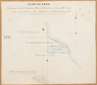
Map, Plan of land purchased by the Bacchus Marsh Shire Council from Mr. T. Low for a deviation of the Melbourne to Ballarat main road. 1877
... Plan of land purchased by the Bacchus Marsh Shire Council from Mr. T. Low for a deviation of the Melbourne to Ballarat main road. 1877...It adjoins the Korkuperrimul Creek on one side which indicates the land is located just a few kilometers to the west of Bacchus Marsh. ...Single page map showing a portion of land purchased by the Bacchus Marsh Shire from Mr Thomas Low for the purpose of a road deviation. ...Standfield, Shire Engineer, Bacchus Marsh, 12/4/77...Shire of Bacchus Marsh...Bacchus Marsh & District Historical Society Lerderderg Library Main Street Bacchus Marsh The date of this plan is 1877 and the land indicted on it required for a road deviation is shaded in blue. ...The date of this plan is 1877 and the land indicted on it required for a road deviation is shaded in blue. It adjoins the Korkuperrimul Creek on one side which indicates the land is located just a few kilometers to the west of Bacchus Marsh. Single page map showing a portion of land purchased by the Bacchus Marsh Shire from Mr Thomas Low for the purpose of a road deviation. Land held by David Robertson is also shown on the map. Scale: 2 chains to 1 inch. Part of a set of maps which are pasted into a bound volume containing 76 maps or plans in total. High resolution digital image stored on BMDHS computer network. Surveyed by W. E. Standfield, Shire Engineer, Bacchus Marsh, 12/4/77bacchus marsh roads and streets, melbourne to ballarat road -
 Bacchus Marsh & District Historical Society
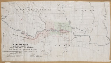
Map, General Plan for Water Supply Works, Shire of Bacchus Marsh 1887
... General Plan for Water Supply Works, Shire of Bacchus Marsh 1887...Debate about water supply and its planning and development took place in the Bacchus Marsh region from the 1850s through into the twentieth century. ...The plan is signed by Bacchus Marsh Shire Engineer, W.E. Standfield. ...General Plan of Water Supply Works in the Shire of Bacchus Marsh. Accompanying application for 2nd additional Loan. ...Shire of Bacchus Marsh...Bacchus Marsh & District Historical Society Lerderderg Library Main Street Bacchus Marsh Debate about water supply and its planning and development took place in the Bacchus Marsh region from the 1850s through into the twentieth century. ...Debate about water supply and its planning and development took place in the Bacchus Marsh region from the 1850s through into the twentieth century. This plan was part of documentation to support an application for an additional loan of money from the Ministry of Water Supply to the Bacchus Marsh Shire Water Supply Trust. The plan includes the route of a proposed water channel in the Parwan area, and other features of water supply infrastructure such as the location of standpipes and gates are also shown on the plan.A single page paper map showing a general plan for the supply of water in the Bacchus Marsh area.The plan shows the route of the 'Main Channel' near the Werribee River and a proposed route for a Parwan Channel. The location of 'Dryden's House' near the Werribee River is also shown and the locations of land held by T. (Tom) Oliver and the Racecourse Reserve in Maddingley. Scale 40 chains to 1 inch. The plan is signed by Bacchus Marsh Shire Engineer, W.E. Standfield. The map is pasted into a bound volume containing 76 maps or plans in total. High resolution digital image stored on BMDHS computer network. General Plan of Water Supply Works in the Shire of Bacchus Marsh. Accompanying application for 2nd additional Loan. Original Waterworks district. Additional area. W.E. Standfield, 30/8/87.water supply, water supply maps, water supply bacchus marsh, irrigation, bacchus marsh victoria maps -
 Bacchus Marsh & District Historical Society
Map, Plan of the second portion of the property of Messers Atkins and Clarke situate at Bacchus Marsh 1856
... Plan of the second portion of the property of Messers Atkins and Clarke situate at Bacchus Marsh 1856...The Bacchus family sold their property in Bacchus Marsh to John Aitkins and Robert Nalder Clarke in March 1851. ...The subdivided land shown was owned by John Aitkins and Robert Nalder Clarke, but previously owned by the Bacchus Family and was in and around their Manor House (Mansion) property in Bacchus Marsh. ...Shire of Bacchus Marsh...Bacchus Marsh & District Historical Society Lerderderg Library Main Street Bacchus Marsh This plan of land allotments for sale indicates part of the property once owned by the Bacchus family in and around the township area of Bacchus Marsh. ...This plan of land allotments for sale indicates part of the property once owned by the Bacchus family in and around the township area of Bacchus Marsh. The Bacchus family sold their property in Bacchus Marsh to John Aitkins and Robert Nalder Clarke in March 1851. Aitkins and Clarke kept the property for a number of years until April 1856 when these allotments were put up for sale.This is a very early land sales plan for agricultural land close to the township of Bacchus Marsh. It therefore provides some clues as to how the early urban development of the township and agricultural development of the nearby area took place. Upon seeing the map in 1911 Bacchus Marsh Express newspaper editor Christopher Crisp wrote "The sale appears to have created the present township, which had a nucleus in earlier times further east", Express, 30 September, 1911, page 3.A single page paper plan showing allotments of land for sale. The subdivided land shown was owned by John Aitkins and Robert Nalder Clarke, but previously owned by the Bacchus Family and was in and around their Manor House (Mansion) property in Bacchus Marsh. This plan shows allotments in the second portion of land to be sold which was located east of the Manor House on the eastern side of the Lerderderg River. The land for sale was made up of 15 allotments. The plan is pasted into a bound volume containing 76 maps or plans in total. BMDHS Loc: AR/B12/S4 Bacchus Marsh Township and Nearby Districts Maps Volume In-house Digital copies: BMDHS, Computer Network: Maps\Bacchus Marsh Township and Nearby Districts Maps Volumebacchus marsh victoria maps, bacchus family, land sales, manor house bacchus marsh -
 Victorian Interpretive Projects Inc.
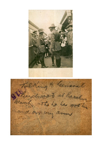
Photograph - digital, General Birdwood at Bacchus Marsh Station
... General Birdwood at Bacchus Marsh Station...Black and white photograph showing a number of Australian soldiers beside a train at Bacchus Marsh Railway station. ...Verso: Talking to General Birdwood at Bacchus Marsh (illegible) he had got his hand on my arm,...Bacchus Marsh, Victoria, Australia...General Birdwood at Bacchus Marsh Station Photograph - digital ...Black and white photograph showing a number of Australian soldiers beside a train at Bacchus Marsh Railway station. Verso: Talking to General Birdwood at Bacchus Marsh (illegible) he had got his hand on my arm,bacchus marsh, world war, world war one, train, railway, birdwood, general birdwood -
 Bacchus Marsh & District Historical Society
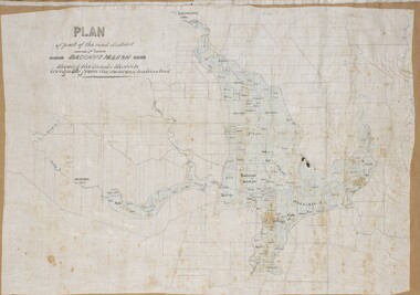
Map, Plan of part of the road district of Bacchus Marsh circa 1856-1862
... Plan of part of the road district of Bacchus Marsh circa 1856-1862...By 1856 the local committee in Bacchus Marsh was constituted as the Bacchus Marsh Road District. ...A single page paper map showing a plan of part of the road district of Bacchus Marsh. The map is pasted into a bound volume containing 76 maps or plans in total. ...Shire of Bacchus Marsh...Bacchus Marsh & District Historical Society Lerderderg Library Main Street Bacchus Marsh Local government in much of Victoria including the Bacchus Marsh area began with the formation of 'local committees'. ...Local government in much of Victoria including the Bacchus Marsh area began with the formation of 'local committees'. These local committees could make representations to a Central Road Board regarding plans for road construction. Road construction and maintenance were seen as the essential tasks of these early local government authorities. By 1856 the local committee in Bacchus Marsh was constituted as the Bacchus Marsh Road District. This entity continued until 1862 when the name changed to the Bacchus Marsh and Maddingley Road District. This new entity lasted until 1871 when the local government authority in accordance with new statewide legislation became known as the Shire of Bacchus Marsh. The title of this plan being a plan of 'a portion of the road district of Bacchus Marsh' suggests that the plan was produced sometime between 1856 and 1862. The main purpose of this map was to shown the irrigable land in the district and the sources from which water for irrigation could be drawn. Bacchus Marsh was an early irrigation district in Victoria. Irrigation trusts were formed in the 1880s and 1890s to manage irrigation districts. But this was the culmination of many years of earlier attempts to construct irrigation systems in the Bacchus Marsh area and create a system to manage irrigation more broadly. This map dating from around 1856-1862 is an important cartographic document which provides evidence of how the early planning for irrigation was developing in the Bacchus Marsh region.A single page paper map showing a plan of part of the road district of Bacchus Marsh. The map is pasted into a bound volume containing 76 maps or plans in total. High resolution digital image stored on BMDHS computer network. bacchus marsh victoria maps, bacchus marsh road district, local government, road districts, irrigation -
 Bacchus Marsh & District Historical Society
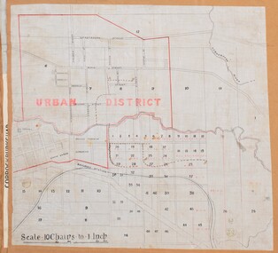
Map, Bacchus Marsh Urban District
... Bacchus Marsh Urban District...The date of this map has not been established but the date would be sometime after 1887 as the Bacchus Marsh Railway Station, which opened in 1887, is shown on the map. ...A single page paper map showing blocks of land in the urban district of Bacchus Marsh. The 'urban district' is indicated by red drawn lines on the map and includes streets and blocks on the northern side of the Werribee River in Bacchus Marsh, and streets and blocks south of the Werribee in Maddingley. ...Shire of Bacchus Marsh...Bacchus Marsh & District Historical Society Lerderderg Library Main Street Bacchus Marsh The date of this map has not been established but the date would be sometime after 1887 as the Bacchus Marsh Railway Station, which opened in 1887, is shown on the map. ...The date of this map has not been established but the date would be sometime after 1887 as the Bacchus Marsh Railway Station, which opened in 1887, is shown on the map. A single page paper map showing blocks of land in the urban district of Bacchus Marsh. The 'urban district' is indicated by red drawn lines on the map and includes streets and blocks on the northern side of the Werribee River in Bacchus Marsh, and streets and blocks south of the Werribee in Maddingley. Scale 10 chains to 1 inch. The map is pasted into a bound volume containing 76 maps or plans in total. High resolution digital image stored on BMDHS computer network. bacchus marsh victoria maps, maddingley victoria maps -
 Bacchus Marsh & District Historical Society
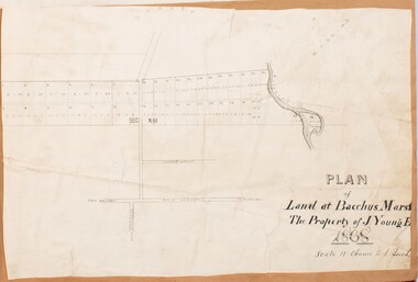
Map, Plan of Land at Bacchus Marsh, the Property of James Young, 1868
... Plan of Land at Bacchus Marsh, the Property of James Young, 1868...The sale notice in the Bacchus Marsh Express of 1st February 1868 page 2, also noted that, ' Plans can be seen at Mr. ...A single page paper map showing 38 blocks of land for sale in 1868 in the vicinity of Masons Lane Bacchus Marsh. Scale 11 chains to 1 inch. The map is pasted into a bound volume containing 76 maps or plans in total. ...Shire of Bacchus Marsh...Bacchus Marsh & District Historical Society Lerderderg Library Main Street Bacchus Marsh James Young was a prominent businessman, land owner and public figure in the early colonial period of Bacchus Marsh. ...James Young was a prominent businessman, land owner and public figure in the early colonial period of Bacchus Marsh. In February 1868 he offered for sale through the agent W. Anderson 38 blocks of land which ran from the Lerderderg RIver westwards beyond Gisborne Road in the vicinity of the present day Masons Land. The land for sale was described as, 'unsurpassed Agricultural Land, in the immediate vicinity of Bacchus Marsh, varying in size from 2 to 12 acres each'. The sale notice in the Bacchus Marsh Express of 1st February 1868 page 2, also noted that, ' Plans can be seen at Mr. Young's Border Mills Store, and at the Border Inn'. One of the largest and most important land sales in the early colonial period of Bacchus Marsh.A single page paper map showing 38 blocks of land for sale in 1868 in the vicinity of Masons Lane Bacchus Marsh. Scale 11 chains to 1 inch. The map is pasted into a bound volume containing 76 maps or plans in total. High resolution digital image stored on BMDHS computer network. land sales bacchus marsh, bacchus marsh victoria maps, james young 1816-1871, masons lane bacchus marsh land sales -
 Bacchus Marsh & District Historical Society
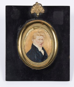
Painting - Portrait, William Henry Bacchus, 1782-1849, Circa 1808-1818
... William Henry Bacchus, 1782-1849...He established a large sheep property and built a notable large Georgian style home which still stands in the town of Bacchus Marsh today. From shortly after his arrival the area became known to the colonists as Bacchus's Marsh, and was later officiaslly named 'Bacchus Marsh' in his memory....Small framed painting of William Henry Bacchus. ...On the reverse is a label which reads: Captain William Henry Bacchus who arrived in the district of Bacchus Marsh early in 1838, was born in Suffolk, England, 1782, and died at Bacchus Marsh on 26 February 1849. ...Bacchus Family William Henry Bacchus 1782-1849 On the reverse is a label which reads: Captain William Henry Bacchus who arrived in the district of Bacchus Marsh early in 1838, was born in Suffolk, England, 1782, and died at Bacchus Marsh on 26 February 1849. ...Artist is not known. Comments recorded at the time of purchase are that it is possibly by 'Plimer'. Andrew Plimer, 1763-1837 and his brother Nathaniel Plimer, 1757-1828, were notable British miniaturist portrait painters.William Henry Bacchus was one of the first British colonists to arrive in the Waddawurrung and Wurundjeri first nations peoples country 55 kilometers west of Melbourne in 1838. He established a large sheep property and built a notable large Georgian style home which still stands in the town of Bacchus Marsh today. From shortly after his arrival the area became known to the colonists as Bacchus's Marsh, and was later officiaslly named 'Bacchus Marsh' in his memory.Small framed painting of William Henry Bacchus. On the reverse is a label which reads: Captain William Henry Bacchus who arrived in the district of Bacchus Marsh early in 1838, was born in Suffolk, England, 1782, and died at Bacchus Marsh on 26 February 1849. His remains were interred in the graveyard of Holy Trinity Church which during his lifetime he had richly endowed with a gift of land. He was a Captain of the 2nd Royal Surrey Militia and formerly Captain of the 18th Light Dragoons.bacchus family, william henry bacchus 1782-1849 -
 Bacchus Marsh & District Historical Society
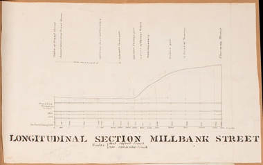
Drawing, Longitudinal Section Millbank Street Bacchus Marsh circa 1905
... Longitudinal Section Millbank Street Bacchus Marsh circa 1905...Millbank Street is a short street located close to the central business and shopping area of Bacchus Marsh. In the early 1900s works to improve the drainage of the street were discussed and planned by Bacchus Marsh Shire Council. ...Single page plan showing a longitudinal section view of MIllbank Street running from Clarinda Street to Grant Street in Bacchus Marsh. The names of Millbank Street property owners, Cain, Shelley, Oliver and Ramsay are marked on this plan. ...Shire of Bacchus Marsh...Bacchus Marsh & District Historical Society Lerderderg Library Main Street Bacchus Marsh Millbank Street is a short street located close to the central business and shopping area of Bacchus Marsh. ...Millbank Street is a short street located close to the central business and shopping area of Bacchus Marsh. In the early 1900s works to improve the drainage of the street were discussed and planned by Bacchus Marsh Shire Council. This plan is most probably the plan discussed at a Shire Council meeting in April 1905. Single page plan showing a longitudinal section view of MIllbank Street running from Clarinda Street to Grant Street in Bacchus Marsh. The names of Millbank Street property owners, Cain, Shelley, Oliver and Ramsay are marked on this plan. Scale: Vertical 10 feet to 1 inch. Horizontal: 100 links to 1 inch Part of a set of maps which are pasted into a bound volume containing 76 maps or plans in total. High resolution digital image stored on BMDHS computer network. bacchus marsh victoria maps, millbank street bacchus marsh -
![Map, Liquidator's sale, 1896. [Woolpack Estate, Bacchus Marsh]](/media/collectors/5e461d8021ea67224c82f2a1/items/6779ee97032b72846b5995f2/item-media/6779ef33032b72846b599b30/item-fit-380x285.jpg?cb=6) Bacchus Marsh & District Historical Society
Bacchus Marsh & District Historical SocietyMap, Liquidator's sale, 1896. [Woolpack Estate, Bacchus Marsh]
... [Woolpack Estate, Bacchus Marsh] ...Anderson and Bence in conjunction with Pearce Brothers also of Bacchus Marsh....Also shown on the map are lots for sale at Robinson's Farm on Coimadai Creek and allotments near Bacchus Marsh railway station, including lots on Government Road (East Maddingley Road), View Street and Government Road (Parwan Road). ...Shire of Bacchus Marsh...[Woolpack Estate, Bacchus Marsh] Map Shire of Bacchus Marsh ...The Woolpack Estate was an area of land owned by various landowners in the Bacchus Marsh area since the early Colonial period of the 1840s. The area was located on the eastern side of the Bacchus Marsh township about 7 kilometers from the town. The Lerderderg River ran through part of the land and so did the Melbourne to Ballarat Road. The historic Woolpack Inn associated with James Crook was also located on this land. By 1896 150 acres of this land was under the control of liquidators for the Federal Bank of Australasia who instructed that the land be sub-divided and sold in lots by public auction. A successful sale was held on 24 June 1896. Most of the blocks of land were sold for higher than expected prices and most of the buyers were people from the town and district of Bacchus Marsh. The map includes various details about the land which is described on the map as an "important sale of rich alluvial irrigable flat land in the Bacchus Marsh Valley, and other properties". The auction was conducted by the local agents W. Anderson and Bence in conjunction with Pearce Brothers also of Bacchus Marsh.A single page paper map showing a plan of 150 acres of land from the Woolpack Estate to be sold in various lots in June 1896. Also shown on the map are lots for sale at Robinson's Farm on Coimadai Creek and allotments near Bacchus Marsh railway station, including lots on Government Road (East Maddingley Road), View Street and Government Road (Parwan Road). No scale provided. The map is pasted into a bound volume containing 76 maps or plans in total. High resolution digital image stored on BMDHS computer network. land sales bacchus marsh, bacchus marsh victoria maps, woolpack estate bacchus marsh victoria -
 Bacchus Marsh & District Historical Society
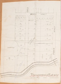
Map, Langmann's Estate Bacchus Marsh
... Langmann's Estate Bacchus Marsh...Little upon of a portion of the map. Little was Bacchus Marsh Shire Secretary and Engineer between 1886 and 1914 which dates the map to some time between 1886 and 1914....A single page paper map showing a portions of land in part of Bacchus Marsh.The area shown is described as Langmann's Estate. ...Shire of Bacchus Marsh...Langmann's Estate Bacchus Marsh Map Shire of Bacchus Marsh ...The date of this map has not been determined. It bears the signature of D.A. Little upon of a portion of the map. Little was Bacchus Marsh Shire Secretary and Engineer between 1886 and 1914 which dates the map to some time between 1886 and 1914.A single page paper map showing a portions of land in part of Bacchus Marsh.The area shown is described as Langmann's Estate. The area is bounded by the Werribee River, Fisken Street, Waddle Street(sic.) (Waddell) and Lord Street. The map is pasted into a bound volume containing 76 maps or plans in total. High resolution digital image stored on BMDHS computer network. bacchus marsh victoria maps -
 Bacchus Marsh & District Historical Society
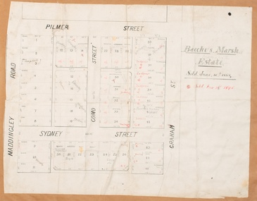
Map, Bacchus Marsh Estate sold 30th June 1888 and sold 28 December 1895
... Bacchus Marsh Estate sold 30th June 1888 and sold 28 December 1895...Blocks of land in this area of Bacchus Marsh were sold in lots between 1888 and the late 1890s. ...Single page map showing allotments of land bounded by Pilmer Street, Graham Street, Sydney Street and Maddingley Road (Grant Street) in Bacchus Marsh.The area is dissected by Como Street down the central area. 43 blocks of land are shown with the names of buyers or sellers in 1888 written in black in. ...Shire of Bacchus Marsh...Bacchus Marsh & District Historical Society Lerderderg Library Main Street Bacchus Marsh Blocks of land in this area of Bacchus Marsh were sold in lots between 1888 and the late 1890s. ...Blocks of land in this area of Bacchus Marsh were sold in lots between 1888 and the late 1890s. This map shows sales made in 1888 and 1895.Single page map showing allotments of land bounded by Pilmer Street, Graham Street, Sydney Street and Maddingley Road (Grant Street) in Bacchus Marsh.The area is dissected by Como Street down the central area. 43 blocks of land are shown with the names of buyers or sellers in 1888 written in black in. Buyers or sellers for December 1895 are written in red ink. Part of a set of maps which are pasted into a bound volume containing 76 maps or plans in total. High resolution digital image stored on BMDHS computer network. bacchus marsh victoria maps, land sales bacchus marsh, pilmer street bacchus marsh, graham street bacchus marsh, sydney street bacchus marsh, como street bacchus marsh, maddingley road bacchus marsh, grant street bacchus marsh -
![Map, Plan showing proposed deviation of the road through McKenzie's Flat to Bacchus Marsh. [Undated]](/media/collectors/5e461d8021ea67224c82f2a1/items/677d22f37f2053f3e5d500dc/item-media/677d25247f2053f3e5d50950/item-fit-380x285.jpg?cb=6) Bacchus Marsh & District Historical Society
Bacchus Marsh & District Historical SocietyMap, Plan showing proposed deviation of the road through McKenzie's Flat to Bacchus Marsh. [Undated]
... Plan showing proposed deviation of the road through McKenzie's Flat to Bacchus Marsh. [Undated]...McKenzie's Flat is a bushland picnic area on the Lerderderg River in the Lerderderg State Park close to Bacchus Marsh. The proposed road deviation shown on this map is very close to a sharp bend in the Lerderderg River which shows an island in the centre of that bend. ...Single page map showing a proposed deviation of the road from McKenzie's Flat to Bacchus Marsh. Scale: 5 chains to 1 inch. Part of a set of maps which are pasted into a bound volume containing 76 maps or plans in total. ...Shire of Bacchus Marsh...Bacchus Marsh & District Historical Society Lerderderg Library Main Street Bacchus Marsh The date of this map or plan is uncertain. ...The date of this map or plan is uncertain. McKenzie's Flat is a bushland picnic area on the Lerderderg River in the Lerderderg State Park close to Bacchus Marsh. The proposed road deviation shown on this map is very close to a sharp bend in the Lerderderg River which shows an island in the centre of that bend. The name of a landholder, J.B. Perry is shown on the map close to the area of the road deviation.The land shown is identified as within the Parish of Merrimu.Single page map showing a proposed deviation of the road from McKenzie's Flat to Bacchus Marsh. Scale: 5 chains to 1 inch. Part of a set of maps which are pasted into a bound volume containing 76 maps or plans in total. High resolution digital image stored on BMDHS computer network. mckenzies flat bacchus marsh, bacchus marsh roads and streets -
 Bacchus Marsh & District Historical Society
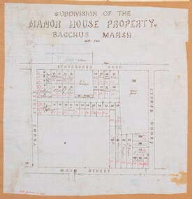
Map, Subdivision of the Manor House Property Bacchus Marsh c.1908
... Subdivision of the Manor House Property Bacchus Marsh c.1908...The Crooks had been resident in Bacchus Marsh since the 1840s and were prominent members of the community. ...The map shows portions of land for sale from the subdivision of the Manor House property in Bacchus Marsh in 1908. The names of most of the buyers of the portions of land have been hand-written into the various allotments they purchased. ...Shire of Bacchus Marsh...Bacchus Marsh & District Historical Society Lerderderg Library Main Street Bacchus Marsh This land sales plan shows allotments of land offered for sale in the inner township area of Bacchus Marsh in 1908. ...This land sales plan shows allotments of land offered for sale in the inner township area of Bacchus Marsh in 1908. The land put up for sale was from the estate of the late Mr and Mrs J.E. Crook. That being James Elijah Crook and his wife Harriet, (nee Athorn). The Crooks had been resident in Bacchus Marsh since the 1840s and were prominent members of the community. They were prominent in the business, social and civic affairs of the town and district. In the 1850s the Crooks acquired the Manor House and nearby land once owned by the Bacchus family. James Crook died in 1889. When Harriet Crook died in February 1908 their estate was offered for sale. This included the large stone home known as the Manor House and various parcels of land including around 50 allotments of land near the Manor House, bounded by Young, Lerderderg, Crook and Main Streets. Most of these allotments of land were sold in October 1908. The Manor House itself was passed in at the sale and continued to be owned by the Crook family for several decades after 1908.A single page map on a single page of a bound volume of maps. The map shows portions of land for sale from the subdivision of the Manor House property in Bacchus Marsh in 1908. The names of most of the buyers of the portions of land have been hand-written into the various allotments they purchased. The maps are pasted into a bound volume containing 76 maps or plans in total. High resolution digital image stored on BMDHS computer network. bacchus marsh victoria maps, land sales bacchus marsh, manor house bacchus marsh, crook family bacchus marsh -
 Bacchus Marsh & District Historical Society
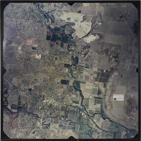
Photograph, Aerial image of Bacchus Marsh and Darley in 1994
... Aerial image of Bacchus Marsh and Darley in 1994...A whole of town and nearby area aerial image of Bacchus Marsh produced for display in the Arbee Real Estate Agency premises in Main Street, Bacchus Marsh....A large framed colour aerial photograph showing the township of Bacchus Marsh, the neighbouring smaller community of Darley, and the nearby areas of both places. ..."Bacchus Marsh - Darley. Aerial Photo 27 November, 1994. ...Bacchus Marsh & District Historical Society Lerderderg Library Main Street Bacchus Marsh A whole of town and nearby area aerial image of Bacchus Marsh produced for display in the Arbee Real Estate Agency premises in Main Street, Bacchus Marsh. ...A whole of town and nearby area aerial image of Bacchus Marsh produced for display in the Arbee Real Estate Agency premises in Main Street, Bacchus Marsh.A large framed colour aerial photograph showing the township of Bacchus Marsh, the neighbouring smaller community of Darley, and the nearby areas of both places. "Bacchus Marsh - Darley. Aerial Photo 27 November, 1994. Presented by Arbee Real Estate "Professionals"'arbee real estate agency bacchus marsh, aerial views bacchus marsh vic. -
 Federation University Historical Collection
Book, Back to Bacchus Marsh, 1957, 1957
... Back to Bacchus Marsh, 1957...A back to Bacchus Marsh was held from 12 to 20 October 1957....Brown covered book of 28 pages including the official programme for back to Bacchus Marsh, 1957. The book includes an historical essay, Maddingley Brown Coal, World war 11, Darley Military Camp, Darley Firebrick Co., industrial changes and numerous advertisements. ...Bacchus Marsh, Victoria, Victoria, 3350, Australia...Barker Library (top floor) Mount Helen goldfields A back to Bacchus Marsh was held from 12 to 20 October 1957. maddingley brown coal world war 11 old woolpack inn darley military camp darley firebrick jim pyke andrew george scott captain moonlite bacchus marsh world war bacchus marsh state school no 28 grant street avenue bacchus marsh war memorial hospital bacchus marsh avenue of honour Captain Bacchus Brown covered book of 28 pages including the official programme for back to Bacchus Marsh, 1957. ...A back to Bacchus Marsh was held from 12 to 20 October 1957.Brown covered book of 28 pages including the official programme for back to Bacchus Marsh, 1957. The book includes an historical essay, Maddingley Brown Coal, World war 11, Darley Military Camp, Darley Firebrick Co., industrial changes and numerous advertisements. Images include: * Grant Street Avenue *St Bernard's new Parish Hall and Schoolrooms * Maddingley No. 2 Cut * Terracing at Maddingley - part of the beautification scheme at Maddingley * Hospital entrance with War memorial Feature * Old Woolpack Inn * Jim Pyke * Infant Welfare and pre-School Centre, Young St * Bacchus Marsh Main Street looking East, 1872 * Andrew George Scott, alias Captain Moonlight * Grant Street Avenue * Ballarat State School No 28 featuring the World War One Memorial Clock maddingley brown coal, world war 11, old woolpack inn, darley military camp, darley firebrick, jim pyke, andrew george scott, captain moonlite, bacchus marsh, world war, bacchus marsh state school no 28, grant street avenue, bacchus marsh war memorial hospital, bacchus marsh avenue of honour, captain bacchus -
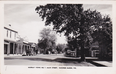 Bacchus Marsh & District Historical Society
Postcard, Main Street, Bacchus Marsh, circa 1950
... Main Street, Bacchus Marsh...The Main Street of Bacchus Marsh underwent significant change from the early 1960s. ...Black and White postcard image of Main Street, Bacchus Marsh dated around 1950. View is looking towards the West....Murray Views No.7, Main Street, Bacchus Marsh, Vic....Bacchus Marsh & District Historical Society Lerderderg Library Main Street Bacchus Marsh The Main Street of Bacchus Marsh underwent significant change from the early 1960s. ...The Main Street of Bacchus Marsh underwent significant change from the early 1960s. Many older buildings began to be demolished after the early 1960s and into the 1980s. This view shows a central section of Main Street before this transformation took place. Produced as part of a series by the Murray Views Postcards and Souvenirs Company.Black and White postcard image of Main Street, Bacchus Marsh dated around 1950. View is looking towards the West.Murray Views No.7, Main Street, Bacchus Marsh, Vic.roads and streets bacchus marsh vic., main street bacchus marsh vic. -
 Bacchus Marsh & District Historical Society
Plaque, Shire of Bacchus Marsh Coat of Arms
... Shire of Bacchus Marsh Coat of Arms...Coat of Arms used by the Shire of Bacchus Marsh in the 1980s and 1990s. A coat of arms has been in use in the Shire at least from the early 20th century. ...Painted cast bronze plaque with inscription on outer white band in black capital lettering: SHIRE OF BACCHUS MARSH. Inner circle painted blue with shield and decorative branches bearing yellow leaves on either side. ...SHIRE OF BACCHUS MARSH....Bacchus Marsh & District Historical Society Lerderderg Library Main Street Bacchus Marsh Coat of Arms used by the Shire of Bacchus Marsh in the 1980s and 1990s. ...Coat of Arms used by the Shire of Bacchus Marsh in the 1980s and 1990s. A coat of arms has been in use in the Shire at least from the early 20th century. This earlier coat of arms described in 1910 featured two cows standing on two bales of lucerne hay, with lucerne fields and fruit trees and rolling hills all round a central valley with two rivers running through it. This early coat of arms was superseded by the slightly different design shown here. When this change took place is not known. When the Bacchus Marsh Shire amalgamated with other Shires to form Moorabool Shire in 1994 this design was superseded.The plaque showing the Bacchus Marsh Shire Coat of Arms is in near perfect condition and as such is an excellent example of the physical symbols used to demonstrate the presence of local government in the Bacchus Marsh region. The images on the coat of arms also depict key economic and agricultural activities in the region which provides historical information about the region in a visual and artistic way.Painted cast bronze plaque with inscription on outer white band in black capital lettering: SHIRE OF BACCHUS MARSH. Inner circle painted blue with shield and decorative branches bearing yellow leaves on either side. Shield quartered and surmounted by stylised sunrise. In four quarters, representations of significant local primary and secondary industries. SHIRE OF BACCHUS MARSH.coats of arms, shire of bacchus marsh -
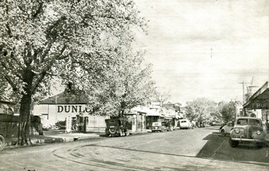 Ballarat Heritage Services
Image - Black and White, Bacchus Marsh, Victoria, c1950, c1950
... Bacchus Marsh, Victoria, c1950...A black and white image of a shopping strip in Bacchus Marsh. ...Bacchus Marsh, Victoria, Australia...Ballarat Heritage Services PO Box 2209 Bakery Hill Post Office goldfields A black and white image of a shopping strip in Bacchus Marsh. Bacchus Marsh, Victoria, c1950 Image - Black and White ...A black and white image of a shopping strip in Bacchus Marsh. -
 Ballarat Heritage Services
Photographs - Colour, Clare Gervasoni, Turf Farm at Bacchus Marsh, 2019, 31/03/2019
... Turf Farm at Bacchus Marsh, 2019...Colour photograph of turf being grown at Bacchus Marsh. ...Bacchus Marsh, Victoria, Australia...Ballarat Heritage Services PO Box 2209 Bakery Hill Post Office goldfields bacchus marsh turf grass agriculture Colour photograph of turf being grown at Bacchus Marsh. ...Colour photograph of turf being grown at Bacchus Marsh. bacchus marsh, turf, grass, agriculture -
 Ballarat Heritage Services
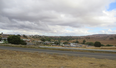
Photograph - Photographs - Colour, Clare Gervasoni, Bacchus Marsh from the Western Highway, 2019, 31/03/2019
... Bacchus Marsh from the Western Highway, 2019...Colour photograph of Bacchus Marsh from the Western Highway. ...Bacchus Marsh, Victoria, Australia...Ballarat Heritage Services PO Box 2209 Bakery Hill Post Office goldfields bacchus marsh Colour photograph of Bacchus Marsh from the Western Highway. ...Colour photograph of Bacchus Marsh from the Western Highway. bacchus marsh -
 Ballarat Heritage Services
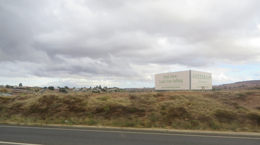
Photographs - Colour, Clare Gervasoni, Underbank Development at Bacchus Marsh from the Western Highway, 2019, 31/03/2019
... Underbank Development at Bacchus Marsh from the Western Highway, 2019...Colour photograph of the Bacchus Marsh suburb of Underbank from the Western Highway. ...Bacchus Marsh, Victoria, Australia...Ballarat Heritage Services PO Box 2209 Bakery Hill Post Office goldfields bacchus marsh Colour photograph of the Bacchus Marsh suburb of Underbank from the Western Highway. ...Colour photograph of the Bacchus Marsh suburb of Underbank from the Western Highway. bacchus marsh -
 Ballarat Heritage Services
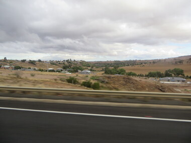
Photographs - Colour, Clare Gervasoni, Bacchus Marsh from the Western Highway, 2019, 31/03/2019
... Bacchus Marsh from the Western Highway, 2019...Colour photograph of the Bacchus Marsh suburb of Underbank from the Western Highway. ...Bacchus Marsh, Victoria, Australia...Ballarat Heritage Services PO Box 2209 Bakery Hill Post Office goldfields bacchus marsh Colour photograph of the Bacchus Marsh suburb of Underbank from the Western Highway. ...Colour photograph of the Bacchus Marsh suburb of Underbank from the Western Highway. bacchus marsh -
Koorie Heritage Trust
Book, Osborn, Betty, The Bacchus Story : A history of Captain W. H. Bacchus of Bacchus Marsh, and his son, 1973
... The Bacchus Story : A history of Captain W. H. Bacchus of Bacchus Marsh, and his son......Bacchus Marsh : Bacchus Marsh & District Historical Society...The Bacchus Story : A history of Captain W. H. Bacchus of Bacchus Marsh, and his son Book Osborn, Betty Bacchus Marsh : Bacchus Marsh & District Historical Society ...xi-xiv; 118 P.; maps; notes; facs.;21 cm.bacchus family. | bacchus family. victoria. bacchus marsh, 1837-1907. -
 Bacchus Marsh & District Historical Society
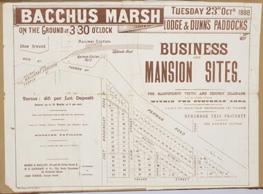
Map, Bacchus Marsh Tuesday 23rd Oct. 1888, Lodge & Dunn's Paddocks 1888. Business and Mansion Sites
... Bacchus Marsh Tuesday 23rd Oct. 1888, Lodge & Dunn's Paddocks 1888. ...This map was created as a plan for an auction of land close to the Bacchus Marsh Railway Station. The auction took place on 23 October 1888. 102 allotments of land from an area known as Lodge and Dunn's paddocks was offered for sale. ...Shire of Bacchus Marsh...Bacchus Marsh & District Historical Society Lerderderg Library Main Street Bacchus Marsh This map was created as a plan for an auction of land close to the Bacchus Marsh Railway Station. ...This map was created as a plan for an auction of land close to the Bacchus Marsh Railway Station. The auction took place on 23 October 1888. 102 allotments of land from an area known as Lodge and Dunn's paddocks was offered for sale. The auction was conducted by auctioneers based in Melbourne and was advertised in Melbourne newspapers as well as in the Bacchus Marsh Express newspaper. The auction plan contains a range of details including the selling agents, Munro and Baillieu; W.P. Lockhart; and John Turner, all of Melbourne, deposit terms for purchases, price of railway passes for a return trip from Melbourne to Bacchus Marsh of 1 shilling, and a description of the land as having 'magnificent views and perfect drainage'. A single page paper map showing allotments of land for sale along the Parwan Road in Maddingley. The map is pasted into a bound volume containing 76 maps or plans in total. High resolution digital image stored on BMDHS computer network. At bottom on left side: 'Harston & Co. Lith, Melb.'land sales bacchus marsh, land sales maddingley, bacchus marsh victoria maps, maddingley victoria maps -
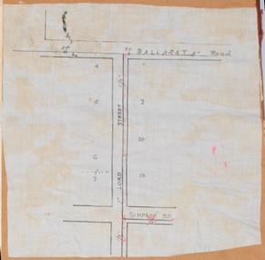 Bacchus Marsh & District Historical Society
Map, Lord Street, Bacchus Marsh. Undated
... Lord Street, Bacchus Marsh. Undated...A small single page map showing the line of Lord Street Bacchus Marsh between Ballarat Road (Main Street) and Simpson Street. ...Shire of Bacchus Marsh...Bacchus Marsh & District Historical Society Lerderderg Library Main Street Bacchus Marsh Bacchus Marsh Victoria Maps Lord Street Bacchus Marsh Maps A small single page map showing the line of Lord Street Bacchus Marsh between Ballarat Road (Main Street) and Simpson Street. ...A small single page map showing the line of Lord Street Bacchus Marsh between Ballarat Road (Main Street) and Simpson Street. Part of a set of maps which are pasted into a bound volume containing 76 maps or plans in total. High resolution digital image stored on BMDHS computer network. bacchus marsh victoria maps, lord street bacchus marsh maps -
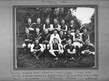 Hymettus Cottage & Garden Ballarat
Photograph, Bacchus Marsh Football Club 1931, 1931
... Bacchus Marsh Football Club 1931...The photograph records the Bacchus Marsh team in 1931 with captain being Michael Taffe from Ballarat. ...Photograph mounted on board with top caption (missing in image) reading "Bacchus Marsh Football Association Football Club 1931 and names written in on mounting board beneath image. ...Inscribed in ink to board above image: Bacchus Marsh Football Association Football Club 1931 and below the image the names of the players including captain and vice captain....Second footballer from right back row has moved blurring his image. Bacchus Marsh Football Club 1931 Photograph Photograph ...The photograph records the Bacchus Marsh team in 1931 with captain being Michael Taffe from Ballarat. Taffe was Assistant Station Master Bacchus Marsh at the time and the photograph records the importance of such sojourners in the community as well as the actual players.Photograph mounted on board with top caption (missing in image) reading "Bacchus Marsh Football Association Football Club 1931 and names written in on mounting board beneath image. Second footballer from right back row has moved blurring his image.Inscribed in ink to board above image: Bacchus Marsh Football Association Football Club 1931 and below the image the names of the players including captain and vice captain.