Showing 57 items matching "bethanga"
-
 Wodonga & District Historical Society Inc
Photograph - North-Eastern Gold Days, 1900
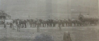
... Bethanga...Bethanga was established as a result of the discovery of gold. ...A large mounted and framed image of horse teams and their owners hauling a large boiler to the gold mine near Bethanga, Victoria. ...On label beneath image: "North-eastern "Gold Days"/ Combined teams hauling a boiler to Bethanga Mines, 1900. Teamsters - Mr. G. Pearce, W. ...Bethanga, Victoria...Gold was first reported in the Bethanga area in 1852. Before 1876 gold mining in the Bethanga district occurred to the north of the town and was known as the 'Talgarno diggings'. ...Bethanga was established as a result of the discovery of gold. Gold was first reported in the Bethanga area in 1852. Before 1876 gold mining in the Bethanga district occurred to the north of the town and was known as the 'Talgarno diggings'. Reports of alluvial gold date back to 1852. Early gold fields were worked at Ruby Creek, Gold Creek and Jarvis Creek. The opening of the Bethanga goldfields began with the discovery of a gold-bearing quartz reef on New Year’s Day 1876. The 'Gift' mine site is located southeast of Kurrajong Gap lookout to the west of Bethanga township. The Great Eastern Copper Smelting Works was opened in 1878. Due to the nature of the gold-bearing quartz reef, the gold was difficult to extract, and the discovery of copper led to a change in focus. It was not until the early 1890s that an efficient technique for extracting the gold from the ore was discovered, and once again gold became the focus, with copper as a by-product. Bethanga was removed from the official list of goldfields in 1912, however some mining activity has taken place since.This image reflects an important time in the development of Bethanga and Northeast Victoria.A large mounted and framed image of horse teams and their owners hauling a large boiler to the gold mine near Bethanga, Victoria. On label beneath image: "North-eastern "Gold Days"/ Combined teams hauling a boiler to Bethanga Mines, 1900. Teamsters - Mr. G. Pearce, W. Chapple, G, Bannon." Donated by Ron Saunders and Barbara Cadman"bethanga, gold mining northeast victoria, gold mining bethanga, bethanga history -
 Wodonga & District Historical Society Inc
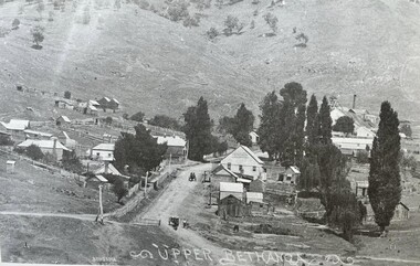
Photograph - Bethanga Township, Thomas Bonsema, c1910
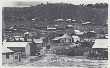
... Bethanga Township...In 1875 gold was discovered there resulting in the establishment of the township named Upper Bethanga north-west of the present town of Bethanga. ...Three black and white images of the township of Bethanga. Photo 1 - Bethanga Photo 2 - Upper Bethanga Photo 3 - Lower Bethanga showing Harris Bros. ...Photo 1 - Bethanga Photo 2 - Upper Bethanga Photo 3 - Lower Bethanga showing Harris Bros. ...The first Europeans to arrive in the area of the current township of Bethanga were explorers Hume and Hovell in 1824. In 1836 the Bethanga pastoral run was taken up by pastoralists from New South Wales and other areas of Victoria. In 1875 gold was discovered there resulting in the establishment of the township named Upper Bethanga north-west of the present town of Bethanga. Four years later copper was discovered, and an adjoining settlement of miners arose, ultimately expanding to become Lower Bethanga and the present town. Our Collection includes several photographs signed BONSEMA WODONGA or sometimes simply TBW. Thomas Peter John Bonsema was born in Wodonga in 1876 to Peter John Bonsema and Mary Ann nee Nash. His name first appears on the Electoral Roll for Wodonga in 1909 and on the Electoral Roll in 1912 he is listed as a photographer. His photographs capture many scenes and events around Wodonga and surrounding areas. Thomas Bonsema married Minna Louisa Jones in 1912. By 1914 he had moved to Chiltern, Victoria where he established Bonsema’s Photographic Studio. From this time onward many of his works bore the signature “BONSEMA CHILTERN”. As well as continuing to photograph landscapes and important buildings, Mr Bonsema was often the official photographer at school and community celebrations. He also sold many framed photographs and postcards from his premises at 68 -70 Conness Street, Chiltern. By 1943 Thomas John Bonsema had relocated to New South Wales and died in Beecroft, NSW on 14th July 1944. Some of his photographs are held in the Victorian State Library and Mitchell Library Sydney Collections.These images are significant because they are the work of a recognised photographer Thomas Bonsema who was born in Wodonga in 1876. They show the township of Bethanga near Wodonga.Three black and white images of the township of Bethanga. Photo 1 - Bethanga Photo 2 - Upper Bethanga Photo 3 - Lower Bethanga showing Harris Bros. General Storebonsema photography, thomas peter john bonsema -
 Wodonga & District Historical Society Inc
Book - Early Days in Bethanga and Springdale, June Philipp, April 1977
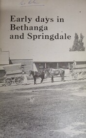
... Early Days in Bethanga and Springdale...A small book of 99 pages including text, sketch maps and images telling the story of the early settlement of Bethanga and Springdale townships in Northeast Victoria....Back cover - Harris Bros/ Importers and General Merchants / Bethanga...Wodonga & District Historical Society Inc Hut 97, Bonegilla Migrant Experience, 132 Bonegilla Road Bonegilla the-murray This item is significant because it documents the early settlement and pioneers of Bethanga. Bethanga History Springdale History This publication was produced for the Bethanga-Springdale Schools Centenary Committee to mark the centenary of the Bethanga State School and the closing of the school at Springdale. ...This publication was produced for the Bethanga-Springdale Schools Centenary Committee to mark the centenary of the Bethanga State School and the closing of the school at Springdale. It traces settlement in the area from the arrival of early pastoralists c1835 followed by the free selectors and later the miners. The remainder of the publication focuses on the establishment of the Bethanga and Springdale Schools and a brief outline of pioneer families of the Bethanga area.A small book of 99 pages including text, sketch maps and images telling the story of the early settlement of Bethanga and Springdale townships in Northeast Victoria.non-fictionThis publication was produced for the Bethanga-Springdale Schools Centenary Committee to mark the centenary of the Bethanga State School and the closing of the school at Springdale. It traces settlement in the area from the arrival of early pastoralists c1835 followed by the free selectors and later the miners. The remainder of the publication focuses on the establishment of the Bethanga and Springdale Schools and a brief outline of pioneer families of the Bethanga area.bethanga history, springdale history -
 Federation University Historical Collection
Letter, Letters from Bethanga Gold Fields Limited to School of Mines Ballarat
... Letters from Bethanga Gold Fields Limited to School of Mines Ballarat......Bethanga...Two handwritten letters from Bethanga Gold Fields Limited to School of Mines Ballarat. signed Harris and Field General Managers. ...Letters from Bethanga Gold Fields Limited to School of Mines Ballarat...Martell Letters Harris and Field Frederick Martell Bethanga Two handwritten letters from Bethanga Gold Fields Limited to School of Mines Ballarat. signed Harris and Field General Managers. ...Ballarat School of Mines is a predecessor of Federation University.Two handwritten letters from Bethanga Gold Fields Limited to School of Mines Ballarat. signed Harris and Field General Managers. Dated 11th October and 13th October 1898bethanga gold fields limited, harris and field general managers, school of mines ballarat, f.j. martell, letters, harris and field, frederick martell, bethanga -
 Wodonga & District Historical Society Inc
Photograph - Bethanga Bridge
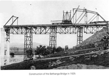
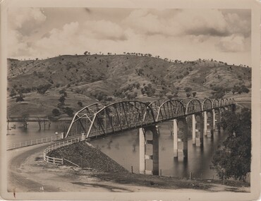
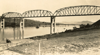
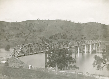
... Bethanga Bridge ...The Bethanga Bridge was built between 1927 and 1930 as a joint venture between Victoria and New South Wales and was a key element of the River Murray Waters Agreement. ...A collection of photos documenting the construction of the Bethanga Bridge which links the States of Victoria and New South Wales as part of the construction of the Hume Dam ....Bethanga Bridge Photograph Bethanga Bridge ...The Bethanga Bridge was built between 1927 and 1930 as a joint venture between Victoria and New South Wales and was a key element of the River Murray Waters Agreement. It consists of nine spans of 82 metres long. Each span is supported between double reinforced concrete pylons and a riveted steel camel back Pratt truss. The overall span of the bridge is a length of 752 metres. It was completed in 1929 at a cost of £194,000. The road deck was initially constructed from timber but was replaced in 1961 with a concrete waffle slab deck 7.7metres wide. In 1961 the bridge deck and truss structure were raised 300 millimetres to allow for the enlargement of the lake. The bridge was designed in NSW by road engineer Percy Alan and the trusses were built by the Charles Ruwolt Pty. Ltd. Charles Ruwolt Pty. Ltd. was originally established by Charles Ruwolt as a foundry at Wangaratta in 1902 and transferred its operations to Richmond, Melbourne in 1914. By 1938 it had become one of the biggest engineering companies in Australia. After Charles Ruwolt’s death in 1946, Vickers Ltd. acquired the company and in 1948 the firm became known as Vickers Ruwolt Pty. Ltd. Because of the Bethanga Bridge’s unique location, over the waters of a dam with the border running down the centre of the body of water, the Bethanga Bridge is the only built structure shared by both Victoria and New South Wales. As the border of New South Wales aligns with the southern bank of the Murray River all of the other bridges along its length are deemed to be in New South Wales. The Bethanga Bridge is listed on both the New South Wales State Heritage Register and the Victorian Heritage Database. In 2015 the Bethanga Bridge was nominated for a heritage award by the Institution of Engineering Australia.These images are significant because they document the construction of a bridge which links Victoria and New South Wales and has been recognised for its historical, technical and engineering significance.A collection of photos documenting the construction of the Bethanga Bridge which links the States of Victoria and New South Wales as part of the construction of the Hume Dam .bethanga bridge, hume dam constuction, charles ruwolt, percy allan engineer -
 Wodonga & District Historical Society Inc
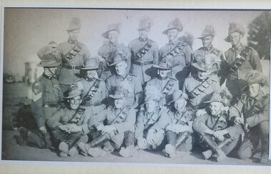
Photograph - Members of the Bethanga Light Horse Troop
... Members of the Bethanga Light Horse Troop...After an extensive recruiting campaign in January 1939 a new troop was raised in Bethanga, Victoria. In December 1941, the regiment converted from horse to mechanised, initially as 8th Reconnaissance Battalion then in July 1942 it became 8th Cavalry Regiment and served in Northern Territory. ...A framed Black and white photograph of Bethanga members of the Australian Light Horse in uniform...A framed Black and white photograph of Bethanga members of the Australian Light Horse in uniform Members of the Bethanga Light Horse Troop Photograph Members of the Bethanga Light Horse Troop ...The 8th Light Horse was initially raised from companies of the colonial Victorian Mounted Rifles located in North-east Victoria following Federation. In 1912 a major reorganisation of the Australian military forces resulted in the regiment being renumbered 16th Light Horse. The Regiment was disbanded in 1919 but soon after was re-raised as the 8th (Indi) Light Horse in the Citizen Military Forces, with the territorial title Indi Light Horse. The Indi Light Horse consisted of 3 squadrons. A squadron consisted of troops in Corryong, Walwa, Tallangatta, Eskdale and Wodonga. After an extensive recruiting campaign in January 1939 a new troop was raised in Bethanga, Victoria. In December 1941, the regiment converted from horse to mechanised, initially as 8th Reconnaissance Battalion then in July 1942 it became 8th Cavalry Regiment and served in Northern Territory. As Japanese threat to the mainland declined the regiment was disbanded.This photo represents a group of Bethanga men who committed to service during World War 2A framed Black and white photograph of Bethanga members of the Australian Light Horse in uniformBack row (left to right), Troopers Keith Cadman, Arthur "Friday" Dower, Bert Sommer, Norm Martin, Andy Mitchell, Tom Pearce; Middle row (left to right). Troop Leader Sergeant Edward "Ted"Davies, Troopers Jack Mortlock, Albert "Ab" Bohun, Aub Cadman, Les Freyer Front row (left to right), Troopers Henry Trenchard, A."Ed" Hertzog, Doug Dower, Nelson "Manny" Green, Eric Wheller, J. Parker.indi light horse, bethanga light horse troop, bethanga history -
 Wodonga & District Historical Society Inc
Booklet - Bethanga: A town full of memories, Norm Martin, 1997
... Bethanga: A town full of memories...bethanga...Norm Martin was a resident and farmer in Bethanga and his family has connections with the area dating back to the 1870s. ...He had three stints as president of the former Tallangatta Shire between the mid-1960s and mid-1980s in a council career which started in the 1950s. bethanga hume weir tallangatta shire norm martin A short history of the town of Bethanga , located on Lake Hume Bethanga: A town full of memories Booklet Bethanga: A town full of memories Norm Martin ...A short history of the town of Bethanga , located on Lake Humenon-fictionA short history of the town of Bethanga , located on Lake Humebethanga, hume weir, tallangatta shire, norm martin -
 The Beechworth Burke Museum
Photograph, c.1927-1930
... Bethanga...This image shows the Punt (a kind of small boat) that took residents of Bethanga across the Murray River before the Bethanga Bridge was built. .... / Our only means of getting out / of Bethanga for the present / Until the bridge is completed / it is 2 miles above the junction / of the Mitta + Murray. ......Bethanga, Victoria...This image shows the Punt (a kind of small boat) that took residents of Bethanga across the Murray River before the Bethanga Bridge was built. ...This image shows the Punt (a kind of small boat) that took residents of Bethanga across the Murray River before the Bethanga Bridge was built. Bethanga Bridge was built between 1927 and 1930, and was made a necessity by the building of the Hume Dam. The Hume Dam, formerly known as the Hume Weir, was in construction between 1919 and 1936, which swelled the Murray River into the floodplain to the East of the dam permanently, creating Lake Hume, and isolating the residents of Bethanga and nearby towns, for whom the trip all the way around the new lake to another river crossing was a massive undertaking. The person who wrote on the back of this card instead chose to cross the river on a boat until the Bethanga Bridge became available. Interestingly, partially submerged trees can be seen in the lake in the background of this photograph, illustrating that the dam had already begun to fill the floodplain even before the bridge was built. This photograph shows the methods the residents of Bethanga used while the Bethanga Bridge was being built. This record is associated with the Heritage Listed sites of the Hume Dam and the Bethanga Bridge, and shows the environment during the process of construction and the creation of Lake HumeSepia rectangular photograph printed on matte photographic paperReverse: 1997.3189 / 84 -19 -1 / This is the snap of the Punt. / Our only means of getting out / of Bethanga for the present / Until the bridge is completed / it is 2 miles above the junction / of the Mitta + Murray. It is / 1/2 a mile wide + runs across / the Murray into NSW / Kodak Print / bethanga, bethanga bridge, hume, hume dam, artificial lake, lake hume, hume weir, flood, floodplain, boat, punt, weir, pier, dock, transport, transportation -
 Wodonga & District Historical Society Inc
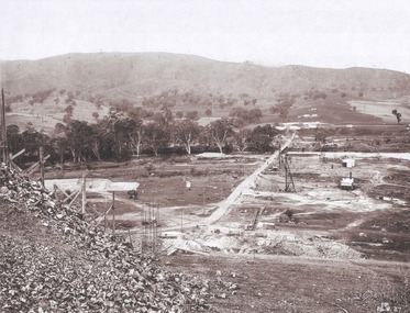
Album - Hume Reservoir Australia Album - Valley of the Murray to be crossed by the Bethanga Bridge 1927
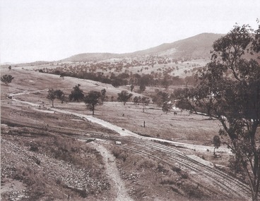
... Hume Reservoir Australia Album - Valley of the Murray to be crossed by the Bethanga Bridge 1927...Valley of the Murray to be crossed by the Bethanga Bridge described in the next photograph. ...Hume Reservoir Australia Album - Valley of the Murray to be crossed by the Bethanga Bridge 1927 Album Hume Reservoir Australia Album - Valley of the Murray to be crossed by the Bethanga Bridge 1927 ...This set of photos is from a leather bound album bearing the inscription "HUME RESERVOIR AUSTRALIA" plus 'The Rt. Hon. L. C. M. S. Amery, P. C., M .P.' all inscribed in gold. It was presented to The Rt. Hon. L. C. M. S. Amery, P. C., M. P, Secretary of State for Dominion Affairs on the occasion of his visit to the Hume Reservoir on 2nd November 1927. This album is of local and national significance as it documents the planning and development of the Hume Reservoir up to 1927. It was the largest water reservoir in the British Empire. The album records the pioneering engineering work that went into its construction.DEPARTMENT OF PUBLIC WORKS, N.S.W. RIVER MURRAY WATERS SCHEME. HUME RESERVOIR. 36. Valley of the Murray to be crossed by the Bethanga Bridge described in the next photograph. (WHS 00731) This view shows the marshalling sidings for trucks below the Quarry, New South Wales, and the branch line to the site of the bridge.hume reservoir australia, river murray waters scheme, hume reservoir construction -
 Wodonga & District Historical Society Inc
Photograph - Redelin Street, Bethanga Victoria, Thomas Bonsema, c1910
... Redelin Street, Bethanga Victoria...In 1875 gold was discovered there resulting in the establishment of the township named Upper Bethanga north-west of the present town of Bethanga. ...In 1875 gold was discovered there resulting in the establishment of the township named Upper Bethanga north-west of the present town of Bethanga. ...The first Europeans to arrive in the area of the current township of Bethanga were explorers Hume and Hovell in 1824. In 1836 the Bethanga pastoral run was taken up by pastoralists from New South Wales and other areas of Victoria. In 1875 gold was discovered there resulting in the establishment of the township named Upper Bethanga north-west of the present town of Bethanga. Four years later copper was discovered, and an adjoining settlement of miners arose, ultimately expanding to become Lower Bethanga and the present town. Our Collection includes several photographs signed BONSEMA WODONGA or sometimes simply TBW. Thomas Peter John Bonsema was born in Wodonga in 1876 to Peter John Bonsema and Mary Ann nee Nash. His name first appears on the Electoral Roll for Wodonga in 1909 and on the Electoral Roll in 1912 he is listed as a photographer. His photographs capture many scenes and events around Wodonga and surrounding areas. Thomas Bonsema married Minna Louisa Jones in 1912. By 1914 he had moved to Chiltern, Victoria where he established Bonsema’s Photographic Studio. From this time onward many of his works bore the signature “BONSEMA CHILTERN”. As well as continuing to photograph landscapes and important buildings, Mr Bonsema was often the official photographer at school and community celebrations. He also sold many framed photographs and postcards from his premises at 68 -70 Conness Street, Chiltern. By 1943 Thomas John Bonsema had relocated to New South Wales and died in Beecroft, NSW on 14th July 1944. Some of his photographs are held in the Victorian State Library and Mitchell Library Sydney Collections.These images are significant because they are the work of a recognised photographer Thomas Bonsema who was born in Wodonga in 1876. They show the township of Bethanga near Wodonga.An image taken from a postcard created by Thomas Bonsema. The scene is looking west towards the Gift Shaft which was mined in 1908.bonsema photography, thomas peter john bonsema -
 Wodonga & District Historical Society Inc
Album - Hume Reservoir Australia Album - Bethanga Bridge Site, August 1927
... Hume Reservoir Australia Album - Bethanga Bridge Site, August 1927...HUME RESERVOIR. 37. Bethanga Bridge Site. A bridge is being built to cross the Reservoir to serve a large area of country which will be cut off from its natural outlets by the submergence of existing bridges when the Reservoir is in being. ...Hume Reservoir Australia Album - Bethanga Bridge Site, August 1927 Album Hume Reservoir Australia Album - Bethanga Bridge Site, August 1927 ...This set of photos is from a leather bound album bearing the inscription "HUME RESERVOIR AUSTRALIA" plus 'The Rt. Hon. L. C. M. S. Amery, P. C., M .P.' all inscribed in gold. It was presented to The Rt. Hon. L. C. M. S. Amery, P. C., M. P, Secretary of State for Dominion Affairs on the occasion of his visit to the Hume Reservoir on 2nd November 1927. This album is of local and national significance as it documents the planning and development of the Hume Reservoir up to 1927. It was the largest water reservoir in the British Empire. The album records the pioneering engineering work that went into its construction.DEPARTMENT OF PUBLIC WORKS, N.S.W. RIVER MURRAY WATERS SCHEME. HUME RESERVOIR. 37. Bethanga Bridge Site. A bridge is being built to cross the Reservoir to serve a large area of country which will be cut off from its natural outlets by the submergence of existing bridges when the Reservoir is in being. The site of the bridge is nearly a mile up the Murray from the Hume Reservoir Quarry. Its length will be approximately half a mile. There will be nine spans of 269 feet with steel truss girders resting on concrete pillars. Some of the pillars are founded on rock while others will rest on nests of reinforced concrete piles. The foundations and concrete piers are in the hands of the Victorian Constructing Authority and the superstructure in those of the New South Wales Authority. August 1927.hume reservoir australia, river murray waters scheme, hume reservoir construction -
 Wodonga & District Historical Society Inc
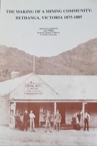
Book - The Making of a Mining Community: Bethanga, Victoria 1875 - 1885
... The Making of a Mining Community: Bethanga, Victoria 1875 - 1885...Wodonga & District Historical Society Inc Hut 97, Bonegilla Migrant Experience, 132 Bonegilla Road Bonegilla the-murray local history VCE Resources Bethanga community Bethanga History A publication by La Trobe University to support the teaching of V.C.E History Unit 1: Local History. ...A publication by La Trobe University to support the teaching of V.C.E History Unit 1: Local History. It is presented as 6 investigations focused on aspects of community through a case study of the Upper Bethanga district in Northeast Victoria from 1875 to 1885.A publication by La Trobe University to support the teaching of V.C.E History Unit 1: Local History. It consists of 94 pages including images, maps and document extracts.A publication by La Trobe University to support the teaching of V.C.E History Unit 1: Local History. It is presented as 6 investigations focused on aspects of community through a case study of the Upper Bethanga district in Northeast Victoria from 1875 to 1885.local history, vce resources, bethanga community, bethanga history -
 Wodonga & District Historical Society Inc
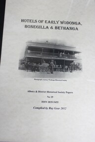
Booklet - Hotels of Early Wodonga, Bonegilla and Bethanga, Ray Gear, 2012
... Hotels of Early Wodonga, Bonegilla and Bethanga...Wodonga & District Historical Society Inc Hut 97, Bonegilla Migrant Experience, 132 Bonegilla Road Bonegilla the-murray hotels wodonga hotels bethanga hotels bonegilla hotels victoria history A collection of the history of early hotels in the Wodonga area Hotels of Early Wodonga, Bonegilla and Bethanga Booklet Hotels of Early Wodonga, Bonegilla and Bethanga Ray Gear ...A collection of the history of early hotels in the Wodonga areanon-fictionA collection of the history of early hotels in the Wodonga areahotels wodonga, hotels bethanga, hotels bonegilla, hotels victoria history -
 Wodonga & District Historical Society Inc
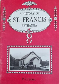
Booklet - A History of St Francis Bethanga, Patricia Packer, 1992
... A History of St Francis Bethanga...Wodonga & District Historical Society Inc Hut 97, Bonegilla Migrant Experience, 132 Bonegilla Road Bonegilla the-murray This item is significant because it documents the St Francis Church in Bethanga and its community. St Francis Church Bethanga Bethanga community The first church in Bethanga was built by the Wesleyans in early 1876 and was also used by other denominations. ...The first church in Bethanga was built by the Wesleyans in early 1876 and was also used by other denominations. In early 1886 the Anglican Church was built followed by St Francis Catholic Church later that year. St Francis Church provided a place of worship for nearly 150 years. It was part of the Parish of Wodonga and the Diocese of Sandhurst. The church was relocated in 1917 after it was decided the original location was unsuitable because of the steepness of its approach. Parishioners found it particularly difficult to attend in winter as the surrounds became wet and muddy. Land was purchased which had stables for horses and coaches that would stop between Wodonga and the Upper Murray. Reverend Dr James Flynn hired a carpenter and other workers to demolish the building and cut the church into sections where it was hauled and rebuilt on the new site in Bridge Street, Bethanga. After changing demographics and a dwindling congregation the last regular Mass was held at St Francis in December 2019. Following a decision to close St Francis Catholic Church a final farewell service on was held on 20th August 2022. The building was sold in October 2023.A small booklet of 56 pages including text and images.The first church in Bethanga was built by the Wesleyans in early 1876 and was also used by other denominations. In early 1886 the Anglican Church was built followed by St Francis Catholic Church later that year. St Francis Church provided a place of worship for nearly 150 years. It was part of the Parish of Wodonga and the Diocese of Sandhurst. The church was relocated in 1917 after it was decided the original location was unsuitable because of the steepness of its approach. Parishioners found it particularly difficult to attend in winter as the surrounds became wet and muddy. Land was purchased which had stables for horses and coaches that would stop between Wodonga and the Upper Murray. Reverend Dr James Flynn hired a carpenter and other workers to demolish the building and cut the church into sections where it was hauled and rebuilt on the new site in Bridge Street, Bethanga. After changing demographics and a dwindling congregation the last regular Mass was held at St Francis in December 2019. Following a decision to close St Francis Catholic Church a final farewell service on was held on 20th August 2022. The building was sold in October 2023.st francis church bethanga, bethanga community -
 Uniting Church Archives - Synod of Victoria
Illuminated Testimonial, Rev W. C. T. Peart
... Peart who was leaving the Wodonga-Bethanga Methodist Circuit to serve King and country. ...The testimonial is signed on behalf of the Wodonga-Bethanga Methodist Circuit by 12 people....Peart who was leaving the Wodonga-Bethanga Methodist Circuit to serve King and country. ...This is a token of appreciation to Rev William Charles J. Peart who was leaving the Wodonga-Bethanga Methodist Circuit to serve King and country. He was minister of the Wodonga-Bethanga circuit in 1914 from where he enlisted in the Light Horse. He afterwards became a gunner in the Field Artillery and was severely gassed, from which he never really recovered. He spent time in hospital and on his return to Australia his circuits were Drouin, Footscray and Merbein. He then had to request leave of absence for six months owing to war disabilities. He was able to return to the ministry. Before enlisting he married Doris Quick who came out of the Daylesford Circuit. The war left a legacy of suffering and limitation with Mr Peart, but he showed a brave face and a steady heart. Paper testimonial mounted on card. The text is gold and there is an image of a draped Australian flag in the top right corner. The testimonial is signed on behalf of the Wodonga-Bethanga Methodist Circuit by 12 people.wodonga-bethanga methodist circuit, rev william charles j. peart 1881-1949, world war 1914 - 1918 -
 Rutherglen Historical Society
Image, c 1930
... Black and white photograph of the Bethanga Bridge with hills in the background....Peterson | Photographer | Hume Reservoir" Black and white photograph of the Bethanga Bridge with hills in the background. ...Black and white photograph of the Bethanga Bridge with hills in the background.On back of photo: "Hume Weir" and an oval rubber stamp "V. Peterson | Photographer | Hume Reservoir"hume dam, hume weir, hume reservoir, lake hume, bethanga bridge -
 The Beechworth Burke Museum
Photograph
... ...Bethanga...Taken between 1928 and 1930, depicted is the Bethanga Bridge under construction. The Bridge was completed in 1930 and was built to assist residents of the Bethanga district to travel to Albury. ...Taken between 1928 and 1930, depicted is the Bethanga Bridge under construction. The Bridge was completed in 1930 and was built to assist residents of the Bethanga district to travel to Albury. ...Taken between 1928 and 1930, depicted is the Bethanga Bridge under construction. The Bridge was completed in 1930 and was built to assist residents of the Bethanga district to travel to Albury. Other bridges would become submerged by the backed-up water of the Murray and Mitta Rivers so the Bethanga bridge was built two miles above the Mitta Weir. The Bethanga Bridge was built north of the future Hume Dam which would be completed in 1936. At 2430 feet long, Bethanga Bridge was the longest road bridge in Australia at the time of its completion. The Bridge is 20 feet wide and made up of nine 270 feet long spans. Materials used include ten tons of paint for the steel works; 1600 tons of steel; 900 tons of timber for the decking; and reinforced concrete for the piers. The tender for the construction was awarded to C. Ruwolt Pty. Ltd., engineers who were located on Victoria Street, West Richmond. The contract was awarded for £71,890. It was predicted between 250 and 300 men would find employment on the project. The news was well received by trade unions at the time as there had been a drop in available engineering work.This photograph is historically significant as it depicts the progress of the Bethanga Bridge construction, which was important infrastructure for the area. It is also a good example of methods used in the area to assist in travel over the river prior to the construction of the Hume Dam.Black and white rectangular photo printed on matte photographic paper.Reverse: 1997 3186 / 84-19-3 / This is the bridge. / It is not yet open to traffic / yet. will not be completed / until May next / It is a wonderful bridge the / pillars are 100 feet high. / KODAK PRINT Envelope Obverse: Peterson PHOTO / Hume Weir Envelope Reverse: BMM 84-20-1,2+3. bethanga bridge, lake hume, hume dam, hume weir, murray river, bridge, bethanga, albury -
 The Beechworth Burke Museum
Photograph, Unknown c.1930s
... Bethanga...This image shows Bethanga Bridge, which was constructed between 1927 and 1930 in Albury, NSW. ...This image shows Bethanga Bridge, which was constructed between 1927 and 1930 in Albury, NSW. ...This image shows Bethanga Bridge, which was constructed between 1927 and 1930 in Albury, NSW. The bridge was a necessity due to the building of the Hume Dam (Wier), 1919-1936. Bethanga Bridge is a long, nine-span, riveted-steel, variable depth, Pratt Truss road bridge of nine principal spans of 82 metres and a total length of 752 metres over the flooded valley of the Murray River, now part of Hume Reservoir. Because of its unique location, over the waters of a dam with the border running down the centre of the body of water, the Bethanga bridge is the only built structure shared by both New South Wales and Victoria. It was built 1.6 kilometres upstream of the dam and in 1961 was raised 300mm, with a concrete deck replacing the original wooden deck. The State Rivers and Water Supply Commission of Victoria and the New South Wales Department of Public Works were responsible for the construction works for the Hume Weir under the River Murray Waters Agreement. It is apparent that a similar joint arrangement was made for the construction of the Bethanga Bridge as part of the Hume Weir works.This photograph of the Bethanga Bridge is of historical significance as it showcases the architectural skills of Percy Allen and Vincent Packer. Additionally, it reveals the environmental landscape of the 1920s-1930s, is linked to the Hume Dam and both New South Wales and Victorian heritage. Unmounted black and white rectangular photograph. Reverse: 1997.3196 84-20-3bethanga, bethanga bridge, hume dam, pratt truss, murray river, hume weir, transportation -
 Bendigo Historical Society Inc.
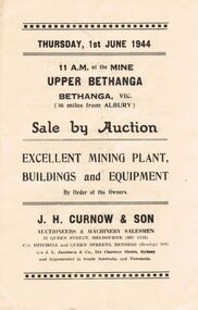
Document - IAN DYETT COLLECTION: AUCTION CATALOGUE - BETHANGA MINE
... Paper catalogue for an auction sale on the 1st June 1944 at the Bethanga Mine, Bethanga, Vic. For sale was Mining Plant, Buildings and Equipment.Sale conducted by permission of the Director of Machine Tools and Gauges. ...History House 11 Mackenzie Street Bendigo goldfields BUSINESS Auctioneers j h curnow & son pty ltd Ian Dyett Collection - Auction Catalogue - Bethanga Mine J H Curnow & Son J L Jamieson W G Wedd Director of Machine Tools and Gauges The Cambridge Press Paper catalogue for an auction sale on the 1st June 1944 at the Bethanga Mine, Bethanga, Vic. ...Paper catalogue for an auction sale on the 1st June 1944 at the Bethanga Mine, Bethanga, Vic. For sale was Mining Plant, Buildings and Equipment.Sale conducted by permission of the Director of Machine Tools and Gauges. J. H. Curnow & Son were the auctioneers.business, auctioneers, j h curnow & son pty ltd, ian dyett collection - auction catalogue - bethanga mine, j h curnow & son, j l jamieson, w g wedd, director of machine tools and gauges, the cambridge press -
 Uniting Church Archives - Synod of Victoria
Book - Book prize, John Bunyan, The Pilgrim's Progress : The Life of Bunyan, c1904
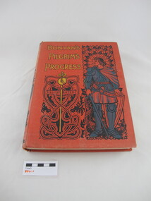
... "May Srewella A reward from the Bethanga Methodist Sunday School Dec 15th/04...Uniting Church Archives - Synod of Victoria 54 Serrell Street Malvern East melbourne Bethanga Methodist Sunday School "May Srewella A reward from the Bethanga Methodist Sunday School Dec 15th/04 On front cover Bunyan's Pilgrim''s Progress. ...On front cover Bunyan's Pilgrim''s Progress. Red linen hardcover book with blue, yellow and black cover and spine decoration and text.fictionbethanga methodist sunday school -
 Bendigo Historical Society Inc.
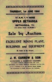
Document - IAN DYETT COLLECTION: AUCTION CATALOGUE - UPPER BETHANGA MINE
... Auction catalogue for a sale on 1st June, 1944 at the Mine Upper Bethanga, Bethanga, Vic. (16 miles from Albury) of Mining Plant, Buildings and Equipment. ...History House 11 Mackenzie Street Bendigo goldfields BUSINESS Auctioneers j h curnow & son pty ltd Ian Dyett Collection - Auction Catalogue - Upper Bethanga Mine J H Curnow & Son J L Jamieson W G Wedd The Cambridge Press Auction catalogue for a sale on 1st June, 1944 at the Mine Upper Bethanga, Bethanga, Vic. (16 miles from Albury) of Mining Plant, Buildings and Equipment. ...Auction catalogue for a sale on 1st June, 1944 at the Mine Upper Bethanga, Bethanga, Vic. (16 miles from Albury) of Mining Plant, Buildings and Equipment. Notice in the front of the catalogue mentioning buyers had to obtain permission from the Director of Machine Tools and Gauges to make purchases of Machine Tools and Allied Equipment at an Auction Sale. J. H. Curnow & Son were the auctioneers. Contains a description of some of the machinery and buildings. The Cambridge Press were the printers of the catalogue.business, auctioneers, j h curnow & son pty ltd, ian dyett collection - auction catalogue - upper bethanga mine, j h curnow & son, j l jamieson, w g wedd, the cambridge press -
 Wodonga & District Historical Society Inc
Book - A Poor Man's Diggings, June Philipp, 1987
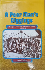
... A publication relating the history of mining at Bethanga in Northeast Victoria, the miners and semi-itinerant workers, who came to the area in the 1870s in search of a fortune and the community they created. ...Wodonga & District Historical Society Inc Hut 97, Bonegilla Migrant Experience, 132 Bonegilla Road Bonegilla the-murray Gold mining Bethanga Miners Victoria History of Bethanga The town of Bethanga is located in the mountainous north-east of Victoria, near the Murray River. ...The town of Bethanga is located in the mountainous north-east of Victoria, near the Murray River. In the 1870s miners and itinerant workers came to the area to seek their fortunes.This history of Bethanga, covering the period from 1875 to 1912, tells the story of these people and the community they created.A publication relating the history of mining at Bethanga in Northeast Victoria, the miners and semi-itinerant workers, who came to the area in the 1870s in search of a fortune and the community they created. Thus publication of 222 pages includes text, images, maps and a detailed index.non-fictionThe town of Bethanga is located in the mountainous north-east of Victoria, near the Murray River. In the 1870s miners and itinerant workers came to the area to seek their fortunes.This history of Bethanga, covering the period from 1875 to 1912, tells the story of these people and the community they created. gold mining bethanga, miners victoria, history of bethanga -
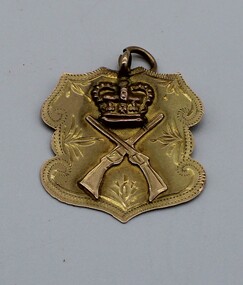 Beechworth RSL Sub-Branch
Medallion
... (15C gold shield worn on FOB chain) inscription – “presented by the Bethanga Friends in recognition of service abroad. ...Beechworth RSL Sub-Branch 99 Ford Street Beechworth high-country (15C gold shield worn on FOB chain) inscription – “presented by the Bethanga Friends in recognition of service abroad. ...(15C gold shield worn on FOB chain) inscription – “presented by the Bethanga Friends in recognition of service abroad. Jan 1920" Presented to Dick Nankervis following his return from active service in WWIRefer to the Word Document in the media file of item 0048Heraldic shield shaped 15C gold medallionFront - cross rifles below a crown with decorative engraving on the edges; mounting ring at centre top of shield Back - Engraved messagemedallion, gold, world war 1, wwi, heraldic shield -
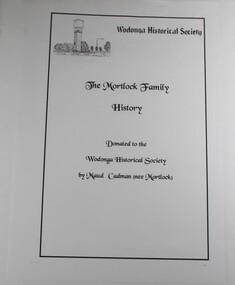 Wodonga & District Historical Society Inc
Book - The Mortlock Family History 1833-2003, R. Polkinghorne & R Mortlock
... ...bethanga...Later branches of the family settled in the Castlemaine area, Wagga Wagga and Bethanga near Wodonga, Victoria. The history is profusely illustrated with maps, family photographs provided by Maud Cadman. ...A detailed history of the Mortlock family, from their convict and then successful settler ancestor, Thomas John Mortlock, through succeeding generations of high-country settlers. Later branches of the family settled in the Castlemaine area, Wagga Wagga and Bethanga near Wodonga, Victoria. The history is profusely illustrated with maps, family photographs provided by Maud Cadman. There is some detail of the methods of settling the high country of the Monaro before the new Land Acts of 1861 and anecdotal reference to one family member running the Post Office at the Prisoner of War Camp at Cowra during World War IInon-fictionA detailed history of the Mortlock family, from their convict and then successful settler ancestor, Thomas John Mortlock, through succeeding generations of high-country settlers. Later branches of the family settled in the Castlemaine area, Wagga Wagga and Bethanga near Wodonga, Victoria. The history is profusely illustrated with maps, family photographs provided by Maud Cadman. There is some detail of the methods of settling the high country of the Monaro before the new Land Acts of 1861 and anecdotal reference to one family member running the Post Office at the Prisoner of War Camp at Cowra during World War IImortlock family, high country, bethanga, thomas mortlock, monaro -
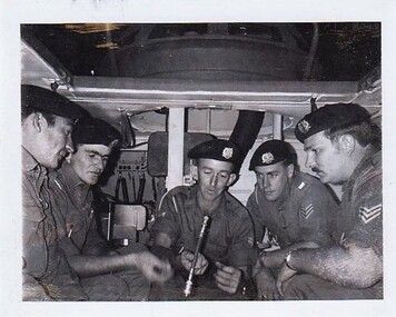 8th/13th Victorian Mounted Rifles Regimental Collection
Photograph
... Brindusic, Lavington, Cpl. P. Russell, Bethanga, Sgt. N. Russell, Wodonga,Sgt. M. Hudson, Lavington,are seen receiving instruction on the CES of the M113 from Cpl. ...Brindusic, Lavington, Cpl. P. Russell, Bethanga, Sgt. N. Russell, Wodonga,Sgt. M. Hudson, Lavington,are seen receiving instruction on the CES of the M113 from Cpl. ...In 1970, 8th/13th Victorian Mounted Rifles changed roles from tank to cavalry and undertook training to convert crewmen to new equipment.Collection of photographs showing an armoured regiment of the Citizen Forces in the 1960s as it transitioned from wheeled armoured vehicles to tanks to M113 armoured personal carriers.Black and white photograph of five 8th/13th Victorian Mounted Rifles soldiers in the interior of a M113 Armoured Personnel Carrier." L to R. : Cpl. E. Delphin, Glenroy, Cpl. M. Brindusic, Lavington, Cpl. P. Russell, Bethanga, Sgt. N. Russell, Wodonga,Sgt. M. Hudson, Lavington,are seen receiving instruction on the CES of the M113 from Cpl. Russell, their instructor on the M113 Conversion Course. " -
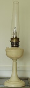 Wodonga & District Historical Society Inc
Functional object - Kerosene Lamp, Aladdin Industries Ltd, 1953-1963
... Gina Elizabeth Harris of Bethanga in Northeast Victoria where electricity was connected on 23 March 1959....Gina Elizabeth Harris of Bethanga in Northeast Victoria where electricity was connected on 23 March 1959. ...Kerosene lamps were used as a main source of lighting throughout Australia prior to the supply of domestic electrical services. This was obviously later in many rural areas. This lamp was used in the home of Mrs. Gina Elizabeth Harris of Bethanga in Northeast Victoria where electricity was connected on 23 March 1959.This lamp is representative of the lamps used throughout Australia prior to the introduction of domestic electricity supplies. This vintage kerosene lamp is model No. 21 which was manufactured by Aladdin Industries in Greenford, Middlesex, England in the 1950s. Base stems were mostly made from wood, turned into several different patterns. More expensive table lamp stems were of metal. Bases were mostly steel filled with sand as a weight. When Bakelite became available it was used extensively in three different colours, although collectors say that white bases were used primarily in hospitals and churches and are more rare. On wick knob: "21/Aladdin Industries Ltd/GREENFORD" Inscribed around burner: "GB Patent No 9. 69-4273-4"kerosene lamp, bakelite, domestic appliances -
 Uniting Church Archives - Synod of Victoria
Photograph, Rev. Norman and Mrs. Lowe, Mid-1960s
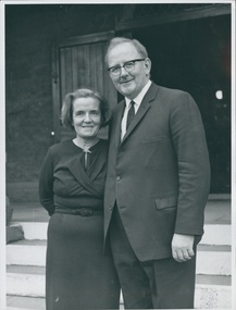
... Norman Lowe's placements: Underbool 1953; Merbein 1955; Wodonga & Bethanga 1960; Immigration chaplain 1961-1962; Carlton & Fitzroy Mission 1963; Church of All Nations 1971; West Heidelberg 1974; Approved appointment Community Health Yallourn 1976. ...Uniting Church Archives - Synod of Victoria 54 Serrell Street Malvern East melbourne Norman Lowe's placements: Underbool 1953; Merbein 1955; Wodonga & Bethanga 1960; Immigration chaplain 1961-1962; Carlton & Fitzroy Mission 1963; Church of All Nations 1971; West Heidelberg 1974; Approved appointment Community Health Yallourn 1976. ...Norman Lowe's placements: Underbool 1953; Merbein 1955; Wodonga & Bethanga 1960; Immigration chaplain 1961-1962; Carlton & Fitzroy Mission 1963; Church of All Nations 1971; West Heidelberg 1974; Approved appointment Community Health Yallourn 1976. Later also Boronia, Dartmoor-Merino, and the Macedonian Church Preston. Lowe was born in 1924, ordained in 1958, and died on 11 November 2013.(F375-1) Lowes standing side by side; (F375-2) Lowe standing by airport exit gate (location unknown) with a large crowd ready to welcome him; (F375-3) Lowes standing amidst the welcoming crowd; (F375-4) Lowe talking to the welcoming crowd; (F375-5) Lowe standing amidst the welcoming crowd; (F375-6) Lowe being hugged by an unknown man from the welcoming crowd."The names of Norman Lowe and Mrs Lowe"lowe, norman -
 Uniting Church Archives - Synod of Victoria
Photograph, Undated, mid-1960s
... Norman Lowe's placements: Underbool 1953; Merbein 1955; Wodonga & Bethanga 1960; Immigration chaplain 1961-1962; Carlton & Fitzroy Mission 1963; Church of All Nations 1971; West Heidelberg 1974; Approved appointment Community Health Yallourn 1976. ...Uniting Church Archives - Synod of Victoria 54 Serrell Street Malvern East melbourne Norman Lowe's placements: Underbool 1953; Merbein 1955; Wodonga & Bethanga 1960; Immigration chaplain 1961-1962; Carlton & Fitzroy Mission 1963; Church of All Nations 1971; West Heidelberg 1974; Approved appointment Community Health Yallourn 1976. ...Norman Lowe's placements: Underbool 1953; Merbein 1955; Wodonga & Bethanga 1960; Immigration chaplain 1961-1962; Carlton & Fitzroy Mission 1963; Church of All Nations 1971; West Heidelberg 1974; Approved appointment Community Health Yallourn 1976. Later also Boronia, Dartmoor-Merino, and the Macedonian Church Preston. Lowe was born in 1924, ordained in 1958, and died on 11 November 2013.B & W photograph of Rev Norman Lowe leaving an unidentified airport.lowe, norman -
 Uniting Church Archives - Synod of Victoria
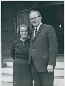
Photograph, Undated, mid-1960s
... Norman Lowe's placements: Underbool 1953; Merbein 1955; Wodonga & Bethanga 1960; Immigration chaplain 1961-1962; Carlton & Fitzroy Mission 1963; Church of All Nations 1971; West Heidelberg 1974; Approved appointment Community Health Yallourn 1976. ...Uniting Church Archives - Synod of Victoria 54 Serrell Street Malvern East melbourne Norman Lowe's placements: Underbool 1953; Merbein 1955; Wodonga & Bethanga 1960; Immigration chaplain 1961-1962; Carlton & Fitzroy Mission 1963; Church of All Nations 1971; West Heidelberg 1974; Approved appointment Community Health Yallourn 1976. ...Norman Lowe's placements: Underbool 1953; Merbein 1955; Wodonga & Bethanga 1960; Immigration chaplain 1961-1962; Carlton & Fitzroy Mission 1963; Church of All Nations 1971; West Heidelberg 1974; Approved appointment Community Health Yallourn 1976. Later also Boronia, Dartmoor-Merino, and the Macedonian Church Preston. Lowe was born in 1924, ordained in 1958, and died on 11 November 2013.B & W photograph of the Rev. Norman and Mrs Lowe, standing outdoors.lowe, norman -
 Uniting Church Archives - Synod of Victoria
Photograph, Undated, mid-1960s
... Norman Lowe's placements: Underbool 1953; Merbein 1955; Wodonga & Bethanga 1960; Immigration chaplain 1961-1962; Carlton & Fitzroy Mission 1963; Church of All Nations 1971; West Heidelberg 1974; Approved appointment Community Health Yallourn 1976. ...Uniting Church Archives - Synod of Victoria 54 Serrell Street Malvern East melbourne Norman Lowe's placements: Underbool 1953; Merbein 1955; Wodonga & Bethanga 1960; Immigration chaplain 1961-1962; Carlton & Fitzroy Mission 1963; Church of All Nations 1971; West Heidelberg 1974; Approved appointment Community Health Yallourn 1976. ...Norman Lowe's placements: Underbool 1953; Merbein 1955; Wodonga & Bethanga 1960; Immigration chaplain 1961-1962; Carlton & Fitzroy Mission 1963; Church of All Nations 1971; West Heidelberg 1974; Approved appointment Community Health Yallourn 1976. Later also Boronia, Dartmoor-Merino, and the Macedonian Church Preston. Lowe was born in 1924, ordained in 1958, and died on 11 November 2013.B & W photograph of Rev and Mrs Norman Lowe, and their son at an unidentified airport.lowe, norman