Showing 408 items matching "bridges -- river yarra"
-
 Eltham District Historical Society Inc
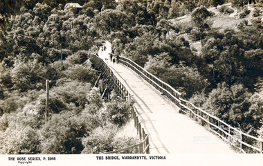
Photograph, The Bridge, Warrandyte, Victoria
... bridges...yarra river...Postcard showing old timber bridge over Yarra River at Warrandyte...Eltham District Historical Society Inc 728 Main Rd Eltham melbourne bridges yarra river warrandyte kangaroo ground road postcards The Rose Series P.2046 Postcard showing old timber bridge over Yarra River at Warrandyte The Bridge, Warrandyte, Victoria Photograph ...Postcard showing old timber bridge over Yarra River at WarrandyteThe Rose Series P.2046bridges, yarra river, warrandyte, kangaroo ground road, postcards -
 Kew Historical Society Inc
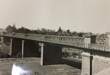
Photograph, Outer Circle Railway Viaduct, 1919
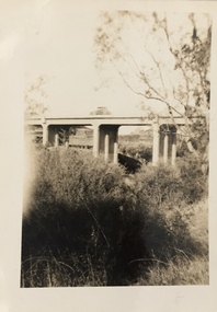
... Photograph of Outer Circle Railway Bridge over River Yarra, Fairfield. Looking toward Lugton Street, showing fence underneath taken from the Chandler Highway. ...Reverse: "Outer Circle Railway Bridge over River Yarra Fairfield, H0276, Property of Miss Foley"...Dateable photo of an important piece of Victorian railway infrastructure. railway viaduct chandler highway Reverse: "Outer Circle Railway Bridge over River Yarra Fairfield, H0276, Property of Miss Foley" Photograph of Outer Circle Railway Bridge over River Yarra, Fairfield. ...Railway Viaduct constructed for the Outer Circle Railway. Bridge designed by John Monash, engineer. Converted into a state highway, 1930s.Dateable photo of an important piece of Victorian railway infrastructure.Photograph of Outer Circle Railway Bridge over River Yarra, Fairfield. Looking toward Lugton Street, showing fence underneath taken from the Chandler Highway. Reverse: "Outer Circle Railway Bridge over River Yarra Fairfield, H0276, Property of Miss Foley"railway viaduct, chandler highway -
 Eltham District Historical Society Inc
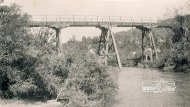
Photograph, Old Warrandyte Bridge
... bridges...yarra river...Postcard showing old timber trestle Warrandyte Bridge over Yarra River...Eltham District Historical Society Inc 728 Main Rd Eltham melbourne bridges yarra river warrandyte kangaroo ground road Postcard showing old timber trestle Warrandyte Bridge over Yarra River Old Warrandyte Bridge Photograph ...Postcard showing old timber trestle Warrandyte Bridge over Yarra Riverbridges, yarra river, warrandyte, kangaroo ground road -
 Kew Historical Society Inc
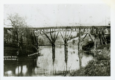
Print, Studley Pk Toll Bridge, July 12 1899
... toll bridges -- river yarra...Kew Historical Society Inc Kew Court House 188 High Street Kew melbourne toll bridges -- river yarra bridges - yarra river -- kew (vic.) penny bridge Reverse: "Studley Pk Toll Bridge / joining Church Street Abbotsford / Penny Bridge" Black and white print photograph of the wooden 'Penny Bridge' at Studley Park. ...Black and white print photograph of the wooden 'Penny Bridge' at Studley Park. The name was colloquially arrived at as a penny wa the toll one paid to cross the bridge. The copy of the postcard identifies the photographers as McAlpin Bros, Richmond.Reverse: "Studley Pk Toll Bridge / joining Church Street Abbotsford / Penny Bridge"toll bridges -- river yarra, bridges - yarra river -- kew (vic.), penny bridge -
 Kew Historical Society Inc
Photograph, Burke Road Bridge, 1930s
... bridge (kew)...bridges -- river yarra...bridge across the Yarra at Burke Road was created as early as 1873. Since that first wooden bridge, a number of later bridges, typically on concrete pylons have been built, in 1926 and again during the 1970s. burke road bridge (kew) bridges -- river yarra Sepia, faded photograph of the Burke Road Bridge linking East Kew and Ivanhoe. ...Without bridges, Kew remained cut off from the City of Melbourne, only being accessible by Punt. Private and public bridges were constructed from the 1850s, beginning with the Hawthorn Bridge linking Bridge and Burwood Roads. A bridge across the Yarra at Burke Road was created as early as 1873. Since that first wooden bridge, a number of later bridges, typically on concrete pylons have been built, in 1926 and again during the 1970s.Sepia, faded photograph of the Burke Road Bridge linking East Kew and Ivanhoe. The previous bridge, constructed in 1926 was submerged beneath the flood waters in the 1934 mega-flood of the Yarra.burke road bridge (kew), bridges -- river yarra -
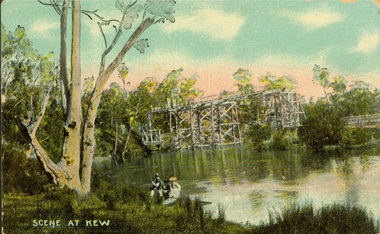
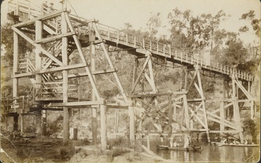
 Kew Historical Society Inc
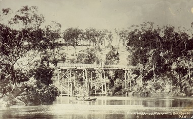
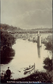
Postcard, J.W.K. & Co, River Yarra near Macauleys' Boathouse Kew, c.1910
... Bridges -- river yarra... yarra bridges - kew (vic.) zig-zag bridge Obverse: "River Yarra near Macauleys' Boathouse Kew". ...The Zig-Zag Bridge which was constructed in the 1870s to link the Yarra Bend Asylum and Kew Asylum. Initially it transported bluestone from the west side of the Yarra to the east during the construction of the Kew Asylum.Real photo postcard of the Zig-Zag Bridge at Kew. In the middle ground there is a rowboat.Obverse: "River Yarra near Macauleys' Boathouse Kew". Reverse: "Gift from L Bennett"bridges -- river yarra, bridges - kew (vic.), zig-zag bridge -
 Kew Historical Society Inc
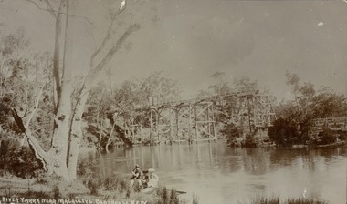
Postcard, River Yarra near Macauleys' Boathouse Kew
... bridge -- Kew (Vic.)...Bridges -- river yarra...Obverse: "River Yarra near Macauleys' Boathouse Kew". Reverse: "Zig Zag Bridge / Gift from L Bennett 1980 / Bridge between Old Asylum & new Mental Hosp. / Kew side"...Kew Historical Society Inc Kew Court House 188 High Street Kew melbourne zig-zag bridge -- Kew (Vic.) Bridges -- river yarra bridges -- kew (Vic.) Obverse: "River Yarra near Macauleys' Boathouse Kew". ...Sepia postcard of the Zig-zaf Bridge joining Yarra Bend and Studley Park. In the foreground is a rowboat in which a man is standing, behind whom are two women in hats and a young child. The man appears to be pushing the boat away from the Bank. In the distance is the wooden Zig-Zag Bridge, constructed in the 1870s to link the Yarra Bend and Kew Lunatic Asylums. [Destroyed by flood, 1929.]Obverse: "River Yarra near Macauleys' Boathouse Kew". Reverse: "Zig Zag Bridge / Gift from L Bennett 1980 / Bridge between Old Asylum & new Mental Hosp. / Kew side"zig-zag bridge -- kew (vic.), bridges -- river yarra, bridges -- kew (vic.) -
 Kew Historical Society Inc
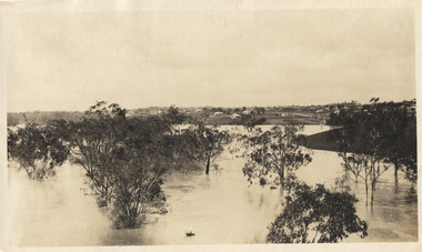
Photograph, Marnie McLeod, Floods on the River Yarra at Kew, 1916
... river yarra...kew...floods 1916...zig-zag bridge...Panoramic view, believed to be looking north towards Fairfield from the Zig-Zag Bridge on the River Yarra. The inscription on the reverese identifies it as taken before 1920....Inscription on reverse in ink "(pre 1920) Flood from Zig-zag bridge Yarra River, Kew Vic."...Together with our original MMBW River Yarra map showing flood levels, these items, when compared allow researchers to gain a visual perspective of the extent of the flood in 1916. river yarra kew floods 1916 zig-zag bridge Inscription on reverse in ink "(pre 1920) Flood from Zig-zag bridge Yarra River, Kew Vic." ...The donation was accompanied by the following letter from the donor: "Hi. I found these in with family photos. Taken by family as Mamie McLeod was living in Fellows Street, Kew, so would be near there. Retain (or discard) as you see fit." [Donor's name and address withheld from public view]. To gain an insight into the flood levels at Kew, it is worth reading newspaper accounts of the event. The Age published an article - Valuable Gardens Destroyed at Kew - on 25 September 1916: "VALUABLE GARDENS DESTROYED AT KEW. From the heights of Studley Park, Kew, a splendid view of the flood waters can be obtained, and yesterday afternoon, despite continuous rain, crowds of citizens assembled there to witness the spectacle. There is a vast stretch of water some 300 or 400 yards broad, above the foot bridge connecting Gipps-street, Collingwood, and Studley Park. The river is only about 3 feet from the top of the embankment connecting with the ramp of the bridge on the Studiey Park side. When the upper llood waters come down it is almost a certainty that tne embankment will be submerged and the bridge rendered impassible. Below the bridge the waters again stretch out, and have submerged all the low-lying land on the Collingwood side and invaded the back premises ot the Kodak Co., Phoenix Biscuit Factory, a tannery adjoining thereto, the Shamrock Brewery, and Chinese gardens in the vicinity. At Walmer-street-bridge, at the end of Studley Park, the low-lying land on the Kew side is covered with water to the depth of many feet. Tlie land in question is owned in a great part by Mr Frank Lavers who haa gone in for intense culture on a pretty liberal scale on both the slopes of the hill and on the river flat. On the latter he is cultivating many acres of asparagus, and has at a considerable cost spent three years in preparing the ground and installing an irrigation system, reticulated from the Yan Yean water supply. This year the asparagus was put down, and the plants were in a promising condition. Tlie flood waters are now flowing fast over the land. The crop is ruined, and three years' work and expenditure destroyed. Mr. Laver's private residence fortunately is high above flood level, but two houses he owns off Young-street have been flooded out. Having been warned in time, the tenants removed their furniture hefore the water came down to Mr. Laver's residence, where they themselves have been given accommodation in the meantime. All the river flats in East Kew are under water. One or two low-lying houses have been flooded. Chipperfield's boat shed at Willsmere is nearly covered, and some Chinese gardens in the vicinity are several feet under water."This, and the other three photographs donated of floods in Kew are believed to be the earliest in the collection. Together with our original MMBW River Yarra map showing flood levels, these items, when compared allow researchers to gain a visual perspective of the extent of the flood in 1916. Panoramic view, believed to be looking north towards Fairfield from the Zig-Zag Bridge on the River Yarra. The inscription on the reverese identifies it as taken before 1920.Inscription on reverse in ink "(pre 1920) Flood from Zig-zag bridge Yarra River, Kew Vic."river yarra, kew, floods 1916, zig-zag bridge -
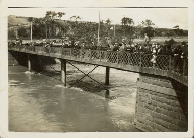
 Eltham District Historical Society Inc
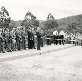
Photograph, Opening Warrandyte Bridge, 8 Dec 1955
... bridges...warrandyte...yarra river...Built at a cost of £75,000 the five-span reinforced concrete bridge replaced the oldest bridge across the Yarra river, linking the Shire of Doncaster-Templestowe on the south bank with Eltham on the north. ...Reid, M.L.A. bridges warrandyte yarra river councillors ceremonies stanley addison Three black and white photographs Opening Warrandyte Bridge Photograph Photograph ...Built at a cost of £75,000 the five-span reinforced concrete bridge replaced the oldest bridge across the Yarra river, linking the Shire of Doncaster-Templestowe on the south bank with Eltham on the north. The bridge was opened by Mr. G. Reid, M.L.A.Three black and white photographsbridges, warrandyte, yarra river, councillors, ceremonies, stanley addison -
 Kew Historical Society Inc
Photograph - Morell Bridge, Yarra River, circa 1953
... Morell Bridge, Yarra River......bridges -- yarra river...Faded black and white photographic positive proof of the Morell Bridge (formerly the Anderson Street Bridge) across the Yarra River near the Botanical Gardens. ...The series includes images of individuals, tea rooms, ferries, motor launches, ocean liners and tugs. melbourne transport bridges -- yarra river morell bridge Anderson street bridge yarra river Faded black and white photographic positive proof of the Morell Bridge (formerly the Anderson Street Bridge) across the Yarra River near the Botanical Gardens. ...This is one of a series of 17 black and white undated photographic proofs donated to the Kew Historical Society in 2013 by the Queenscliffe Historical Museum. The series includes images of individuals, tea rooms, ferries, motor launches, ocean liners and tugs. Faded black and white photographic positive proof of the Morell Bridge (formerly the Anderson Street Bridge) across the Yarra River near the Botanical Gardens. Princess Bridge can be seen through the arches of the Morell Bridge. The undated photographic positive was probably taken in the 1950s.melbourne, transport, bridges -- yarra river, morell bridge, anderson street bridge, yarra river -
 Melbourne Tram Museum
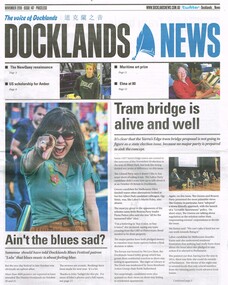
Newspaper, Docklands News, "Tram bridge is alive and well", Nov. 2018
... Bridges... Yarra River...Newspaper clipping from "Docklands News" - December 2018, No. 147, titled "Tram bridge is alive and well" about the possible construction of a tramway bridge over the Yarra River in the Docklands, Yarra Edge district and the relationship with the Vic. ...Melbourne Tram Museum 8 Wallen Road Hawthorn melbourne Trams tramways Docklands New Tramway Bridges Yarra River Newspaper clipping from "Docklands News" - December 2018, No. 147, titled "Tram bridge is alive and well" about the possible construction of a tramway bridge over the Yarra River in the Docklands, Yarra Edge district and the relationship with the Vic. ...Newspaper clipping from "Docklands News" - December 2018, No. 147, titled "Tram bridge is alive and well" about the possible construction of a tramway bridge over the Yarra River in the Docklands, Yarra Edge district and the relationship with the Vic. State election that was held on 24/11/2018. Clipping spreads over three pages. Discusses other election issues.trams, tramways, docklands, new tramway, bridges, yarra river -
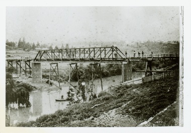
![The Fairfield Bridge [circa 1891]](/media/collectors/550653872162f11fb04854aa/items/579eab98d0cdd117c4af1c89/item-media/579eac23d0cdd117c4afb1ad/item-fit-380x285.jpg?cb=6) Kew Historical Society Inc
Kew Historical Society IncPrint, The Fairfield Bridge [circa 1891], c. 1891
... "Outer Circle Railway Bridge over River Yarra at Fairfield (last section of line opened 1891)"...Together it forms the largest privately-donated collection within the archives of the Kew Historical Society. fairfield bridge chandler highway bridge dorothy rogers john monash outer circle railway "Outer Circle Railway Bridge over River Yarra at Fairfield (last section of line opened 1891)" A reproduction of a photograph of the Fairfield Bridge. ...This work forms part of the collection assembled by the historian Dorothy Rogers, that was donated to the Kew Historical Society by her son John Rogers in 2015. The manuscripts, photographs, maps, and documents were sourced by her from both family and local collections or produced as references for her print publications. Many were directly used by Rogers in writing ‘Lovely Old Homes of Kew’ (1961) and 'A History of Kew' (1973), or the numerous articles on local history that she produced for suburban newspapers. Most of the photographs in the collection include detailed annotations in her hand. The Rogers Collection provides a comprehensive insight into the working habits of a historian in the 1960s and 1970s. Together it forms the largest privately-donated collection within the archives of the Kew Historical Society.A reproduction of a photograph of the Fairfield Bridge. The bridge was one of the first constructed for the Outer Circle Railway in 1891. Its supervising engineer was [Sir] John Monash. The bridge was later to be repurposed as a road linking the Chandler Highway to Fairfield."Outer Circle Railway Bridge over River Yarra at Fairfield (last section of line opened 1891)"fairfield bridge, chandler highway bridge, dorothy rogers, john monash, outer circle railway -
![Photograph - Construction of the F19 [Eastern Freeway], Ron Setford, May 1976](/media/collectors/550653872162f11fb04854aa/items/6815afa28b33318343789e1c/item-media/6815afc88b33318343789fc9/item-fit-380x285.jpg?cb=6) Kew Historical Society Inc
Kew Historical Society IncPhotograph - Construction of the F19 [Eastern Freeway], Ron Setford, May 1976
... "Main bridges over Yarra River / Kew - Fairfield"...Ron Setford Eastern Freeway F19 Freeway "Main bridges over Yarra River / Kew - Fairfield" Photograph Construction of the F19 [Eastern Freeway] Ron Setford ...Ron Setford and his wife Grace Setford lived in Tanner Avenue, East Kew, from c.1946 to c.1995. A keen photographer, he recorded the changing face of Kew over a 20 year period. Apart from 30 photographs of built structures and places in Kew dating from 1960 and 1961, 145 of his 35mm colour slides chronicle the development of the F19 (later renamed Eastern) Freeway through the Yarra Valley in Kew over a five year period from c.1972 to c.1977. This important collection was donated to the Society by his granddaughter in 2025.This collection of 175 35mm slides is of local and statewide significance, owing to its subject matter, particularly the major development of road transport infrastructure during the 1970s with the construction of the Eastern Freeway. The photographer also took care to annotate and date most of his slides which enable the researcher to pinpoint temporal and spatial locations."Main bridges over Yarra River / Kew - Fairfield"ron setford, eastern freeway, f19 freeway -
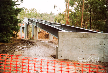
 Eltham District Historical Society Inc
Photograph, Doug Orford, Commencement of bridge works across Yarra River at rear of Eltham Lower Park, May 2004, 2004
... Commencement of bridge works across Yarra River at rear of Eltham Lower Park, May 2004...bridges...yarra river...Eltham District Historical Society Inc 728 Main Rd Eltham melbourne bridges yarra river eltham eltham south templestowe eltham lower park lenister farm homestead road Two colour photographs showing commencement of construction of Eltham-Templestowe footbridge over Yarra River off Homestead Road, Eltham which was completed July 2004. ...Two colour photographs showing commencement of construction of Eltham-Templestowe footbridge over Yarra River off Homestead Road, Eltham which was completed July 2004.bridges, yarra river, eltham, eltham south, templestowe, eltham lower park, lenister farm, homestead road -
 Eltham District Historical Society Inc
Photograph, Doug Orford, Bridge works across Yarra River at rear of Eltham Lower Park, June 2004, 2004
... Bridge works across Yarra River at rear of Eltham Lower Park, June 2004...bridges...yarra river...Eltham District Historical Society Inc 728 Main Rd Eltham melbourne bridges yarra river eltham eltham south templestowe eltham lower park lenister farm homestead road Three colour photographs showing commencement of construction of Eltham-Templestowe footbridge over Yarra River off Homestead Road, Eltham which was completed July 2004. ...Three colour photographs showing commencement of construction of Eltham-Templestowe footbridge over Yarra River off Homestead Road, Eltham which was completed July 2004.bridges, yarra river, eltham, eltham south, templestowe, eltham lower park, lenister farm, homestead road -
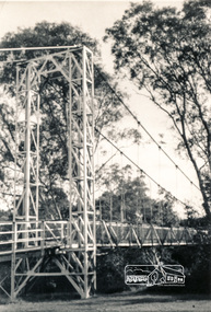 Eltham District Historical Society Inc
Photograph, Pedestrian suspension bridge over the Yarra River at Lower Plenty
... Pedestrian suspension bridge over the Yarra River at Lower Plenty...bridges...yarra river...Yarra at Templestowe. It was built in the 1950’s as a seminary for the Blessed Sacrament Fathers. Because of the poor and circuitous road access, a suspension footbridge was built across the river. As well as providing easy access for the priests residents of Templestowe could attend services at the seminary. The bridge... is now part of the Yarra Trails system. bridges yarra river odyssey house bonds road lower plenty seminary blessed sacrament fathers Two black and white photographs of footbridge over Yarra River, part of the Ruffey Trail just off the Main Yarra Trail near the former seminary (now Odyssey House) Lower Plenty Pedestrian suspension bridge over the Yarra River at Lower Plenty Photograph ...Odyssey House drug rehabilitation centre in Bonds Road, Lower Plenty is a distinctive landmark, especially when viewed from across the Yarra at Templestowe. It was built in the 1950’s as a seminary for the Blessed Sacrament Fathers. Because of the poor and circuitous road access, a suspension footbridge was built across the river. As well as providing easy access for the priests residents of Templestowe could attend services at the seminary. The bridge is now part of the Yarra Trails system.Two black and white photographs of footbridge over Yarra River, part of the Ruffey Trail just off the Main Yarra Trail near the former seminary (now Odyssey House) Lower Plentybridges, yarra river, odyssey house, bonds road, lower plenty, seminary, blessed sacrament fathers -
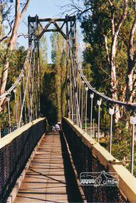 Eltham District Historical Society Inc
Photograph, Pedestrian suspension bridge over the Yarra River at Lower Plenty
... Pedestrian suspension bridge over the Yarra River at Lower Plenty...bridges...yarra river...Yarra at Templestowe. It was built in the 1950’s as a seminary for the Blessed Sacrament Fathers. Because of the poor and circuitous road access, a suspension footbridge was built across the river. As well as providing easy access for the priests residents of Templestowe could attend services at the seminary. The bridge... is now part of the Yarra Trails system. bridges yarra river lower plenty seminary blessed sacrament fathers odyssey house bonds road Colour photograph of footbridge over Yarra River, part of the Ruffey Trail just off the Main Yarra Trail near the former seminary (now Odyssey House) Lower Plenty Pedestrian suspension bridge over the Yarra River at Lower Plenty Photograph ...Odyssey House drug rehabilitation centre in Bonds Road, Lower Plenty is a distinctive landmark, especially when viewed from across the Yarra at Templestowe. It was built in the 1950’s as a seminary for the Blessed Sacrament Fathers. Because of the poor and circuitous road access, a suspension footbridge was built across the river. As well as providing easy access for the priests residents of Templestowe could attend services at the seminary. The bridge is now part of the Yarra Trails system.Colour photograph of footbridge over Yarra River, part of the Ruffey Trail just off the Main Yarra Trail near the former seminary (now Odyssey House) Lower Plentybridges, yarra river, lower plenty, seminary, blessed sacrament fathers, odyssey house, bonds road -
 Eltham District Historical Society Inc
Photograph, Doug Orford, Bridge works across Yarra River at rear of Eltham Lower Park, June 2004, 2004
... Bridge works across Yarra River at rear of Eltham Lower Park, June 2004...bridges...yarra river...Eltham District Historical Society Inc 728 Main Rd Eltham melbourne bridges yarra river eltham eltham south templestowe eltham lower park lenister farm homestead road Three colour photographs showing commencement of construction of Eltham-Templestowe footbridge over Yarra River off Homestead Road, Eltham which was completed July 2004. ...Three colour photographs showing commencement of construction of Eltham-Templestowe footbridge over Yarra River off Homestead Road, Eltham which was completed July 2004.bridges, yarra river, eltham, eltham south, templestowe, eltham lower park, lenister farm, homestead road -
 Eltham District Historical Society Inc
Photograph, Doug Orford, Bridge works across Yarra River at rear of Eltham Lower Park, June 2004, 2004
... Bridge works across Yarra River at rear of Eltham Lower Park, June 2004...bridges...yarra river...Eltham District Historical Society Inc 728 Main Rd Eltham melbourne bridges yarra river eltham eltham south templestowe eltham lower park lenister farm homestead road Three colour photographs showing commencement of construction of Eltham-Templestowe footbridge over Yarra River off Homestead Road, Eltham which was completed July 2004. ...Three colour photographs showing commencement of construction of Eltham-Templestowe footbridge over Yarra River off Homestead Road, Eltham which was completed July 2004.bridges, yarra river, eltham, eltham south, templestowe, eltham lower park, lenister farm, homestead road -
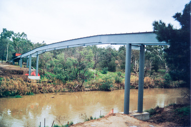
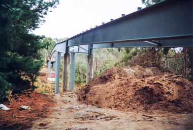
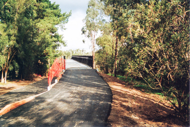 Eltham District Historical Society Inc
Photograph, Doug Orford, Completion of bridge works across Yarra River at rear of Eltham Lower Park, July 2004
... Completion of bridge works across Yarra River at rear of Eltham Lower Park...bridges...yarra river...Yarra River off Homestead Road, Eltham which was completed in July 2004. The Yarra River Footbridge was opened in August 2004 and links the Diamond Creek Trail between the Shire of Nillumbik and City of Manningham. It is a shared pathway and also links with the Main Yarra Trail. It affords lovely views over the Yarra River. bridges ...Bitumen shared pathway under construction at the new Eltham-Templestowe footbridge over the Yarra River off Homestead Road, Eltham which was completed in July 2004. The Yarra River Footbridge was opened in August 2004 and links the Diamond Creek Trail between the Shire of Nillumbik and City of Manningham. It is a shared pathway and also links with the Main Yarra Trail. It affords lovely views over the Yarra River.Three colour photographs showing commencement of construction of Eltham-Templestowe footbridge over Yarra River off Homestead Road, Eltham which was completed July 2004. Third photograph of dedictaion plaque at opening 30 Aug 2004bridges, yarra river, eltham south, eltham lower park, lenister farm, homestead road, asphaldt, bitumen, shared pathway, diamond creek trail -
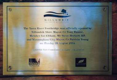 Eltham District Historical Society Inc
Photograph, Doug Orford, Completion of bridge works across Yarra River at rear of Eltham Lower Park, August 2004
... Completion of bridge works across Yarra River at rear of Eltham Lower Park...bridges...yarra river...Yarra River Footbridge opened by Nillumbik Shire Mayor Cr. Tony Ranuic, Member for Eltham, Mr Steve Herbert MP, and Manningham City Mayor, Cr. Patricia Young on Monday 30 August 2004. Nillumbik Shire Couuncil acknowledges the support of the Victorian State Government and City of Manningham. The footbridge links the Diamond Creek Trail between the Shire of Nillumbik and City of Manningham. It is a shared pathway and also links with the Main Yarra Trail. It affords lovely views over the Yarra River. bridges ...Plaque commemorating the opening of the Yarra River Footbridge opened by Nillumbik Shire Mayor Cr. Tony Ranuic, Member for Eltham, Mr Steve Herbert MP, and Manningham City Mayor, Cr. Patricia Young on Monday 30 August 2004. Nillumbik Shire Couuncil acknowledges the support of the Victorian State Government and City of Manningham. The footbridge links the Diamond Creek Trail between the Shire of Nillumbik and City of Manningham. It is a shared pathway and also links with the Main Yarra Trail. It affords lovely views over the Yarra River.One of three colour photographsbridges, yarra river, eltham south, eltham lower park, lenister farm, homestead road, plaque, yarra river footbridge, steve herbert, tony ranic, patricia young -
 Eltham District Historical Society Inc
Photograph, Doug Orford, Bridge across Yarra River, Kangaroo Ground - Warrandyte Road, Warrandyte, 1991, 1991
... Bridge across Yarra River, Kangaroo Ground - Warrandyte Road, Warrandyte, 1991...bridges...yarra river...Eltham District Historical Society Inc 728 Main Rd Eltham melbourne From a collection of 35 photos taken by Doug Orford at 35 specific locations along the exact boundary of the then Shire of Eltham. bridges yarra river warrandyte Colour photograph Bridge across Yarra River, Kangaroo Ground - Warrandyte Road, Warrandyte, 1991 Photograph Photograph Doug Orford ...From a collection of 35 photos taken by Doug Orford at 35 specific locations along the exact boundary of the then Shire of Eltham.Colour photographbridges, yarra river, warrandyte -
 Kew Historical Society Inc
Photograph - Second Johnston Street Bridge in Flood, 1934
... bridge...bridges - yarra river -- kew (vic.)...Kew Historical Society Inc Kew Court House 188 High Street Kew melbourne Johnston street bridge bridges - yarra river -- kew (vic.) flood -- 1934 Annotated on reverse: "Gift of G.S. ...Original, small black and white print photograph of crowds lining the Johnston Street Bridge watching the flood waters below. The annotation on the reverse clarifies that Kew is in the distance.Annotated on reverse: "Gift of G.S. Beard / 2nd bridge / Johnston St. Studly Park Rd. Bridge looking towards Kew / 1st bridge 1858–1876, 2nd bridge built (bad bend), 1876–1958, 3rd bridge 1958, lined up Johnston St and Studley Park Rd."johnston street bridge, bridges - yarra river -- kew (vic.), flood -- 1934 -
 Kew Historical Society Inc
Postcard, Scene at Kew
... bridges - yarra river -- kew (vic.)...Kew Historical Society Inc Kew Court House 188 High Street Kew melbourne bridges - yarra river -- kew (vic.) zig-zag bridge postcards -- kew (vic.) ...Colourised owl photo postcard entitled;led 'Scene at Kew'. In the background is the Zig-Zag Bridge.Obverse: "Scene at Kew". Reverse: "Zig Zag Bridge adj[acent] Kew Asylum / now demolished / in this era / now called / Donated by Mrs B Challen"bridges - yarra river -- kew (vic.), zig-zag bridge, postcards -- kew (vic.) -
 Kew Historical Society Inc
Postcard - Zig-Zag Bridge
... bridges - yarra river -- kew (vic.)...Kew Historical Society Inc Kew Court House 188 High Street Kew melbourne bridges - yarra river -- kew (vic.) zig-zag bridge Reverse: "Old Tramway Bridge / erected early 1850s / Zig Zag Bridge below mental grounds / washed away in flood / linked the mental asylums / donated by G.L. ...Sepia postcard of the Zig-Zag Bridge at Kew. The bridge was constructed in the 1870s to link the Yarra Bend Asylum and Kew Asylum. Initially it transported bluestone from the west side of the Yarra to the east during the construction of the Kew Asylum.Reverse: "Old Tramway Bridge / erected early 1850s / Zig Zag Bridge below mental grounds / washed away in flood / linked the mental asylums / donated by G.L. Beard"bridges - yarra river -- kew (vic.), zig-zag bridge -
 Kew Historical Society Inc
Print - Walmer Street Foot Bridge, 1901
... bridges - yarra river -- kew (vic.)...Yarra. A section of pipe on the near side of the bridge is a remnant of the irrigation pipes that carried water from above Dight's falls to the Melbourne Botanic Gardens. The former bridge, constructed in 1896 was swept away in the 1901 Flood. It has two major brick piers while the remainder of the trestle supports are metal. The original photograph from which this copy was made was taken after 1901 as it shows the second bridge under construction. Houses in Young Street, Kew, can be seen on the far side of the river...Kew Historical Society Inc Kew Court House 188 High Street Kew melbourne bridges - yarra river -- kew (vic.) Walmer street bridge -- Kew (Vic.) ...Photographic print of the Walmer Street Bridge. The view of the Bridge is from the Abbotsford side of the Yarra. A section of pipe on the near side of the bridge is a remnant of the irrigation pipes that carried water from above Dight's falls to the Melbourne Botanic Gardens. The former bridge, constructed in 1896 was swept away in the 1901 Flood. It has two major brick piers while the remainder of the trestle supports are metal. The original photograph from which this copy was made was taken after 1901 as it shows the second bridge under construction. Houses in Young Street, Kew, can be seen on the far side of the river.Reverse: " Walmer St footbridge 1901 being repaired after flood / Constructed 1892 substantially renewed in 1901 and in 1928 / Rebuilt in 1977 by Kew Council aided by State funding. Won for designer Martin Aylard a New Zealand award presented by the timber Research & Development Assoc / Site of Simpsons Road passenger foot ferry". bridges - yarra river -- kew (vic.), walmer street bridge -- kew (vic.) -
 Kew Historical Society Inc
Postcard, River Yarra near Macauleys' Boathouse Kew, c.1910
... ...bridges - yarra river -- kew (vic.)...Obverse: "River Yarra near Macauleys' Boat House Kew". Reverse: "(Pipe Water Line) / Kew to Fairfield above boat house / Pipe Bridge / Received from L. ...This bridge was destroyed in the 1934 Flood and later reconstructed. bridges - kew (vic.) bridges - yarra river -- kew (vic.) pipe bridge Obverse: "River Yarra near Macauleys' Boat House Kew". ...The Pipe Bridge was constructed to bring fresh water from Fairfield to Kew. This bridge was destroyed in the 1934 Flood and later reconstructed.Early sepia real photo postcard of the first Pipe Bridge bringing water from the Yan Yean Reservoir to Kew. The site is upriver of the original Macauley's boathouse. Obverse: "River Yarra near Macauleys' Boat House Kew". Reverse: "(Pipe Water Line) / Kew to Fairfield above boat house / Pipe Bridge / Received from L. Bennett 1980".bridges - kew (vic.), bridges - yarra river -- kew (vic.), pipe bridge -
 Kew Historical Society Inc
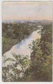
Postcard, River Yarra at Studley Park, Kew, c.1908
... ...bridges - yarra river -- kew (vic.)...Hand-tinted postcard of the River Yarra in Studley Park, Kew. The birds-eye view is of a bridge on the Yarra (Johnston Street?) ...His business at 271 Little Collins Street offered Christmas cards, booklets, calendars, and leather goods as well as postcards and albums. river yarra -- kew (vic.) william thompson pater w.t.p. postcards -- kew postcards -- studley park bridges - yarra river -- kew (vic.) ...Colour-tinted postcard, titled in red upper left: “RIVER YARRA AT STUDLEY PARK, KEW”. On the divided reverse, the card is addressed to “MISS JOLLEY / MELB. TRAM & O[MNIBUS]. CO / BOURKE STREET, MELB”. The sender has dated the card 21.12.08. In the upper right corner, there is a pink Victorian one penny postage stamp; sent from Melbourne on 22DE 08. (The division of the reverse of the postcard, allowing a message to be written on one half and the address on the other, was not permitted in Australia until 1905.) The manufacturer of the postcard is indicated by the initials “W.T.P”, printed in a green floral diamond, printed centre top. This was the trademark of WT Pater, printers & stationers. William Thompson Pater was born in Melbourne in 1861. His business at 271 Little Collins Street offered Christmas cards, booklets, calendars, and leather goods as well as postcards and albums.Hand-tinted postcard of the River Yarra in Studley Park, Kew. The birds-eye view is of a bridge on the Yarra (Johnston Street?) linking Kew and Abbotsford as it appeared in c.1908. On the Abbotsford side of the river, fields lead down to the river, with some remnant trees. The Kew side of the river, in contrast, due to its steep banks, retains its original vegetation. In the distance is industrial development, in what might be Fairfield and Alphington.“RIVER YARRA AT STUDLEY PARK, KEW”river yarra -- kew (vic.), william thompson pater, w.t.p., postcards -- kew, postcards -- studley park, bridges - yarra river -- kew (vic.) -
 Kew Historical Society Inc
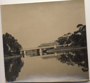
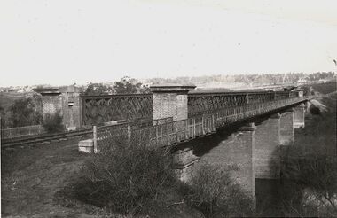
Photograph, Outer Circle Railway Bridge over River Yarra, c.1900
... Outer Circle Railway Bridge over River Yarra...The bridge has a cantilevered walkway along the west side. ...The Chandler Highway Bridge crosses the Yarra River and connects Alphington and Kew. ...Outer Circle Railway Bridge over River Yarra (now Chandler Highway) - note bridge over line on Kew side for Asylum Farm". ...Outer Circle Railway Bridge over River Yarra (now Chandler Highway) - note bridge over line on Kew side for Asylum Farm". ...This photograph forms part of the Eric Sibly collection of images and information relating to the Outer Circle Railway which he donated to the Kew Historical Society in 1974. Heritage Victoria Citation (Abridged) "The Chandler Highway Bridge, a 137 metre wrought iron lattice-truss girder bridge with four spans supported on red brick piers with moulded bluestone cappings. The bridge has a cantilevered walkway along the west side. ...The Chandler Highway Bridge crosses the Yarra River and connects Alphington and Kew. It was completed in November 1890 as part of the Outer Circle Railway Line.Black & white photograph of the railway viaduct over Yarra River looking south towards Kew.Reverse: "Pre 1930. Outer Circle Railway Bridge over River Yarra (now Chandler Highway) - note bridge over line on Kew side for Asylum Farm". KH - 56. Kew Historical Society.chandler highway, railway bridges - kew (vic), sir john monash, outer circle railway, river yarra - kew (vic) -
 Ballarat Heritage Services
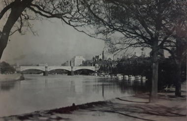
Image, Above Princes Bridge, Melbourne
... yarra river...princes bridge...Photograph of the Princes Bridge on the Yarra River, Melbourne....Ballarat Heritage Services PO Box 2209 Bakery Hill Post Office goldfields melbourne yarra river princes bridge Photograph of the Princes Bridge on the Yarra River, Melbourne. ...Photograph of the Princes Bridge on the Yarra River, Melbourne.melbourne, yarra river, princes bridge