Showing 44 items matching "brown plains road"
-
 Rutherglen Historical Society
Photograph - Image, 1920 (Approximate)
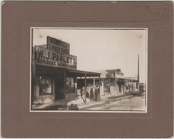
... ...brown plains road...On reverse of mount: "Brown Plains Road / Rutherglen"...Parlett's neice is a concert pianist parletts store w j parlett bob ready audley street brown plains road On reverse of mount: "Brown Plains Road / Rutherglen" Photograph of Parlett's Store, Rutherglen with Mr W.J. ...Parlett's store was situated in Audley Street opposite the wheat silos. Ada Parlett, W. T. Parlett's neice is a concert pianistPhotograph of Parlett's Store, Rutherglen with Mr W.J. Parlett and Mr Bob Ready standing outside store, black and white, mounted on a thick beige card.On reverse of mount: "Brown Plains Road / Rutherglen"parletts store, w j parlett, bob ready, audley street, brown plains road -
 Warrnambool and District Historical Society Inc.
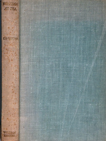
Book - Bible, Thomas Bankes, The Christian's New and Complete Family Bible, 1786
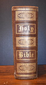
... road This Bible, we believe, dates from 1786 and is the work of the Reverend Thomas Bankes a well known cleric and author of both secular and religious books in the late 18th century. He was a Vicar in a parish in Monmouthshire, England. The local owner of the Bible is unknown. This Bible is retained for its antiquarian interest. 18th Century literature family bible 1786 bible warrnambool bankes bible This is a family bible circa late 1700's The book has a plain brown ...This is a family bible circa late 1700'sThe book has a plain brown leather cover, the front of which is scuffed, stained and completely detached from the spine. On the spine is printed Bankes's Bible, an alternative title. The pages contain text, black and white plates, images and engravings. Some of the pages are torn, others have been repaired with paste. The dedication by Thomas Bankes, a clergyman, is to his Bishop Lord James Beauclerc. All the 's' letters are written as ' f'.non-fictionThis is a family bible circa late 1700's18th century literature, family bible, 1786 bible, warrnambool, bankes bible -
 Warrnambool and District Historical Society Inc.
Education kit - CD, Quest for the Mahogany Ship, 2014
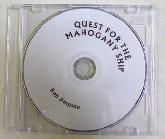
... road This CD relates the story of the quest to discover the Mahogany ship wreck which purportedly lies to the west of Warrnambool and is believed to be either a Spanish or Portuguese ship. It is named the mahogany ship due to the dark colour of the wood seen by early settlers. The story of the Mahogany ship is an integral part of Warrnambool's maritime history Mahogany Ship warrnambool history warrnambool shipwrecks ‘Quest For the Mahogany Ship, Rob Simpson’ This a DVD with a plain white face with brown printing on it. ...This CD relates the story of the quest to discover the Mahogany ship wreck which purportedly lies to the west of Warrnambool and is believed to be either a Spanish or Portuguese ship. It is named the mahogany ship due to the dark colour of the wood seen by early settlers.The story of the Mahogany ship is an integral part of Warrnambool's maritime historyThis a DVD with a plain white face with brown printing on it. ‘Quest For the Mahogany Ship, Rob Simpson’mahogany ship, warrnambool history, warrnambool shipwrecks -
 Kiewa Valley Historical Society
Map - Bogong High Plains
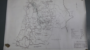
... Kiewa Valley Historical Society Mount Beauty Information Centre 31 Bogong High Plains Rd Mt Beauty high-country Bogong high Plains showing mountains, places, roads and rivers Historical changes of infrastructure on the Bogong High Plains bogong high plains map Bogong High Plains, hand written and 'copied with considerable simplification from F.C.V. (Falls Creek V.?) 'Feathetop' L 'Tawonga'. Paper is yellowed, writing is brown ...Bogong high Plains showing mountains, places, roads and riversHistorical changes of infrastructure on the Bogong High PlainsBogong High Plains, hand written and 'copied with considerable simplification from F.C.V. (Falls Creek V.?) 'Feathetop' L 'Tawonga'. Paper is yellowed, writing is brown.bogong high plains map -
 Kiewa Valley Historical Society
Map - Bogong High Plains - Grazing Runs, Grazing Run Boundaries 1960 - Soil Conservation Authority
... brown print. Bogong High Plains from Feathertop in the west to Mt Nelse in the east showing physical boundaries including the Kiewa Hydro Electric Scheme, roads, rivers and mountains. ...plains kiewa valley families White paper with brown print. Bogong High Plains from Feathertop in the west to Mt Nelse in the east showing physical boundaries including the Kiewa Hydro Electric Scheme, roads, rivers and mountains. ...Cattle grazing on the Bogong High Plains during summer commenced in the 1840s and continued for many years. The Soil Conservation Authority recorded each family's area boundaries which were updated in June 1972 and continued to be adjusted until cattle were banned in 2005. The tradition of cattle grazing continues to be controversial.Holders of grazing rights for grazing on the Bogong High Plains were allocated specific areas recorded by the Soil Conservation Authority in 1972. Cattle have been banned in the Alpine National Park due to their impact on the environment.White paper with brown print. Bogong High Plains from Feathertop in the west to Mt Nelse in the east showing physical boundaries including the Kiewa Hydro Electric Scheme, roads, rivers and mountains. Names of families with grazing runs and the boundaries are shown.cattlemen, grazing runs, bogong high plains, kiewa valley families -
 Kiewa Valley Historical Society
Map - Kiewa Scheme General Plan
... Plains Rd Mt Beauty high-country Existing and possible future roads are numbered and named 1 - 45. The plan is based on an aerial photos taken March 1945. It includes revisions up to 1951. Signed by H.H.C. Williams, construction engineer. Mountains, rivers, roads and SECV places are named, also SECV infrastructure and construction eg. workers camps, Power stations. Significant for the information re the Kiewa Hydro Electric Scheme's development. bob duncan kiewa hydro electric scheme secv khes development Handwritten: 'Bob Duncan' Yellowed paper with brown ...Existing and possible future roads are numbered and named 1 - 45. The plan is based on an aerial photos taken March 1945. It includes revisions up to 1951. Signed by H.H.C. Williams, construction engineer. Mountains, rivers, roads and SECV places are named, also SECV infrastructure and construction eg. workers camps, Power stations.Significant for the information re the Kiewa Hydro Electric Scheme's development.Yellowed paper with brown print. Kiewa Scheme general plan showing its development. A lot of information is recorded. Note: Dyeline print was used which causes fading when exposed to light. Handwritten: 'Bob Duncan'bob duncan, kiewa hydro electric scheme, secv, khes development -
 Kiewa Valley Historical Society
Maps 3D - National Parks
... roads etc. Digital information is now available. These photographs give the topography and contours of vast local areas eg. Mt Feathertop and Tawonga township.when used with a stereoscope. Maps showing topography National Parks stereoscope Identified and catalogued by National Parks Black and white large aerial photos of the Bogong High Plains area. 14 to 20 of them all on thick paper and the same size as the brown wooden box which holds them. ...Used by the employees of National Parks. The maps show the topography and contours in 3D when used with the stereoscope KVHS 0743. This enables the photographed area to be compared to previous photos and enables the planning of construction of eg. new roads etc. Digital information is now available.These photographs give the topography and contours of vast local areas eg. Mt Feathertop and Tawonga township.when used with a stereoscope. Black and white large aerial photos of the Bogong High Plains area. 14 to 20 of them all on thick paper and the same size as the brown wooden box which holds them. The box hasn't got a lid at the top.Identified and catalogued by National Parksmaps showing topography, national parks, stereoscope -
 Kiewa Valley Historical Society
Maps - Tourist
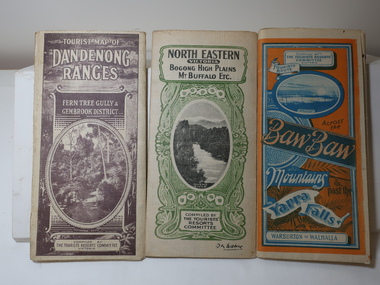
... Brown cover. dated 6-4-33. Govt. printer showing roads, tracks in red and heights of the land. 2. Tourist Map of Warburton, Mt Baw Baw, and Walhalla. Blue and Orange cover. dated 23-5-33 Govt. printer. 3 different maps of each area showin roads, tracks and timber tramways.Also in red and blue. 3. Tourist Map of North Eastern Victoria including Bogong High Plains...Plains Map 1933 snow poles By Authority of H.J. Green - 6 pence. Dept of Lands and Survey, Melbourne 3 Tourist location maps (folded) and printed on parchment. 1. Tourist map of the Dandenong Ranges. Brown cover. dated 6-4-33. Govt. printer showing roads ...These maps were all dated 1933 which was before the construction of the Kiewa Hydro Electric Scheme and when Tawonga was spelt Towonga. North East Victoria in 1933 was before the construction of the Kiewa Hydro Electric Scheme so the townships of Mt Beauty and Bogong are not shown. The description of the Snow Lines was important as skiers, bushwalkers and campers relied on them. The details on the map include "ADB. Numbered from A.1-377 round plates. CD Numbered from C 1-235 square plates. Poles about 3 chains apart 27 to the mile." 3 Tourist location maps (folded) and printed on parchment. 1. Tourist map of the Dandenong Ranges. Brown cover. dated 6-4-33. Govt. printer showing roads, tracks in red and heights of the land. 2. Tourist Map of Warburton, Mt Baw Baw, and Walhalla. Blue and Orange cover. dated 23-5-33 Govt. printer. 3 different maps of each area showin roads, tracks and timber tramways.Also in red and blue. 3. Tourist Map of North Eastern Victoria including Bogong High Plains Mt Buffalo Etc. Green cover. dated June 1933 Govt. printer. Main map and insert titled Bogong High Plains. Showing roads , tracks and tram ways. On insert showing snow poles. Also Red and Blue and mountains.By Authority of H.J. Green - 6 pence. Dept of Lands and Survey, Melbourne1933 maps, tourism maps, bogong high plains map 1933, snow poles -
 Orbost & District Historical Society
newspapers, February, March 1971
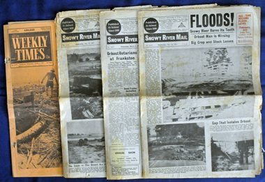
... plain. Records say that "The brown floodwater stain in Bass Strait could be seen from passing airliners." Considerable damage was done to railway infrastructure, roads and farms. ...plain. Records say that "The brown floodwater stain in Bass Strait could be seen from passing airliners." Considerable damage was done to railway infrastructure, roads and farms. ...The 1971 flood was the the worst flood on record. At Jarrahmond it was at least 11 metres and up to one and a half kilometres wide on the flats causing enormous damage to the flood plain. Records say that "The brown floodwater stain in Bass Strait could be seen from passing airliners." Considerable damage was done to railway infrastructure, roads and farms. More information from the APRIL, 2008 newsletter by John Phillips. (see orbosthistory.com.au) These newspapers are contemporary records of a significant local event.Four newspapers relating to the floods in 1971. They contain news articles and photographs of the floods in Orbost in early 1971. 2556.1 is the Weekly Times dated 3.3.1971 and has an orange cover. 2556.2 is a Snowy River Mail dated 17.2.1971. 2556.3 is a Snowy River Mail dated 10.2.1971. 2556.4 is a Snowy River Mail dated 3.3.1971.floods-orbost-1971 snowy-river-mail weekly-times newspapers -
 Warrnambool RSL Sub Branch
Book, SWASTIKA AT SEA
... Warrnambool RSL Sub Branch Cnr Merri & Liebig Streets Warrnambool great-ocean-road ww2. german navy Subtitle: The Struggle and Destruction of the German Navy 1939-1945 Author C. D. Bekker Publisher William Kimber London Year Published 1953 Hard Cover. Colour Blue; Spine faded to Brown. Cover Plain ...Hard Cover. Colour Blue; Spine faded to Brown. Cover Plain; Title, Author, Publisher on Spine. Subtitle: The Struggle and Destruction of the German Navy 1939-1945 Author C. D. Bekker Publisher William Kimber London Year Published 1953ww2. german navy -
 Bendigo Historical Society Inc.
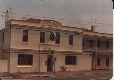
Photograph - BENDIGO HOTEL COLLECTION: FLEECE INN HOTEL, STRICKLAND ROAD, BENDIGO
... Road, Bendigo. Two storey hotel, plain façade LH side, two storey verandah RH side. Painted cream with brown trim. ...Road, Bendigo. Two storey hotel, plain façade LH side, two storey verandah RH side. Painted cream with brown trim. ...Colour photograph: Fleece Inn Hotel, Strickland Road, Bendigo. Two storey hotel, plain façade LH side, two storey verandah RH side. Painted cream with brown trim. Written on pediment on top of hotel 'Fleece Inn' with scroll either side. Corrugated iron roof visible, 3 chimneys.bendigo, hotel, gold mines hotel -
 Flagstaff Hill Maritime Museum and Village
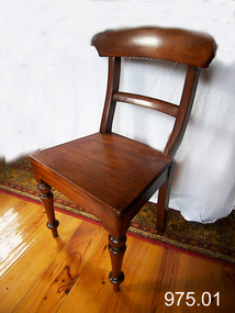
Chair
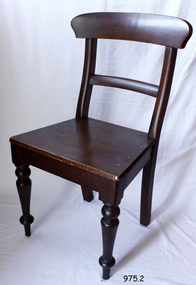
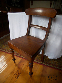
... Flagstaff Hill Maritime Museum and Village 89 Merri Street Warrnambool great-ocean-road flagstaff hill warrnambool shipwrecked-coast flagstaff-hill flagstaff-hill-maritime-museum maritime-museum shipwreck-coast flagstaff-hill-maritime-village Chair wooden with straight back & 3 back supports & with carved diamond motif, 2 turned legs at front, plain legs at back, upholstered in a brown material Chair ...Chair wooden with straight back & 3 back supports & with carved diamond motif, 2 turned legs at front, plain legs at back, upholstered in a brown materialflagstaff hill, warrnambool, shipwrecked-coast, flagstaff-hill, flagstaff-hill-maritime-museum, maritime-museum, shipwreck-coast, flagstaff-hill-maritime-village -
 Glenelg Shire Council Cultural Collection
Clothing - Collar box and collars, n.d
... Glenelg Shire Council Cultural Collection History House Cliff Street Portland great-ocean-road Front: 'Betty Vivian, 22 Otway Street Portland' handwritten inside lid a) Brown, rectangular cardboard box, marked 'Collars and ties'. Leather straps, inside black and white check. b - v) 21 collars, plain, striped and checked Identification numbers 7480 a - v Clothing Collar box and collars ...a) Brown, rectangular cardboard box, marked 'Collars and ties'. Leather straps, inside black and white check. b - v) 21 collars, plain, striped and checked Identification numbers 7480 a - vFront: 'Betty Vivian, 22 Otway Street Portland' handwritten inside lid -
Glenelg Shire Council Cultural Collection
Certificate - Temperance Society Certificate, Sands & McDougall Limited Melbourne, c. 1904
... road Certificate issued by the Temperance Society, issued to Nellie Vivian. Buff cardboard, front illustrated with Australian native flora and fauna with a coloured Temperance Society logo. Plain section in centre of certificate for details of member, pledge etc, in dark brown ...Certificate issued by the Temperance Society, issued to Nellie Vivian. Buff cardboard, front illustrated with Australian native flora and fauna with a coloured Temperance Society logo. Plain section in centre of certificate for details of member, pledge etc, in dark brown print. Member's details in ink. -
 Glenelg Shire Council Cultural Collection
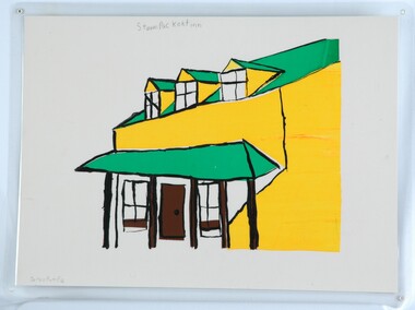
Print, Steampacket Inn, 1983-1984
... road CEMA Art Collection. Part of "A Community View" 150 years in Portland Screenprint Exhibition. Part of Angela Gee Residency 1983 and 1984. Front: Darren Pumpa (lower left) Steam Packet Inn (upper centre) (pencil) Back: 50 Laminated screenprint of a drawing of a building. The details of the building are done in thick black lines with patches of green, yellow and brown. The background has been left as the plain ...CEMA Art Collection. Part of "A Community View" 150 years in Portland Screenprint Exhibition. Part of Angela Gee Residency 1983 and 1984.Laminated screenprint of a drawing of a building. The details of the building are done in thick black lines with patches of green, yellow and brown. The background has been left as the plain paper.Front: Darren Pumpa (lower left) Steam Packet Inn (upper centre) (pencil) Back: 50 -
 Orbost & District Historical Society
black and white photograph, February 1971
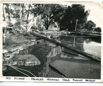
... plain. Records say that "The brown floodwater stain in Bass Strait could be seen from passing airliners." Considerable damage was done to railway infrastructure, roads and farms. ...plain. Records say that "The brown floodwater stain in Bass Strait could be seen from passing airliners." Considerable damage was done to railway infrastructure, roads and farms. ...This photograph was taken near the Snowy River Bridge on the the old Princes Highway in Orbost, near the caravan park. The 1971 flood was the the worst flood on record. At Jarrahmond it was at least 11 metres and up to one and a half kilometres wide on the flats causing enormous damage to the flood plain. Records say that "The brown floodwater stain in Bass Strait could be seen from passing airliners." Considerable damage was done to railway infrastructure, roads and farms. More information from the APRIL, 2008 newsletter by John Phillips. (see orbosthistory.com.au)This is pictorial evidence of a significant local event. Floods have been an integral part of Orbost's history for hundreds of years.A black / white photograph of debris, fallen power lines, a tree across the highway and floodwaters across the road.on front at bottom - handwritten in upper case print - " 1971 FLOOD PRINCES HIGHWAY NEAR SNOWY BRIDGE"floods-orbost-1971 -
 Orbost & District Historical Society
black and white photograph, February 1971
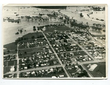
... plain. Records say that "The brown floodwater stain in Bass Strait could be seen from passing airliners." Considerable damage was done to railway infrastructure, roads and farms. ...plain. Records say that "The brown floodwater stain in Bass Strait could be seen from passing airliners." Considerable damage was done to railway infrastructure, roads and farms. ...This photograph is an aerial view of the township of Orbost taken by the Bairnsdale Advertiser newspaper. It was taken from the northern end of the town. The 1971 flood was the the worst flood on record. At Jarrahmond it was at least 11 metres and up to one and a half kilometres wide on the flats causing enormous damage to the flood plain. Records say that "The brown floodwater stain in Bass Strait could be seen from passing airliners." Considerable damage was done to railway infrastructure, roads and farms. More information from the APRIL, 2008 newsletter by John Phillips. (see orbosthistory.com.au)This is a pictorial record of a significant event in the history of Orbost,A black / white aerial photograph of a township with floodwaters in the background.on back - "Note main current through the lagoon 1971."orbost-floods-1971 bairnsdale-advertiser orbost-township -
 Orbost & District Historical Society
black and white photographs, 15th February 1971
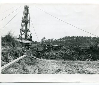
... plain. Records say that "The brown floodwater stain in Bass Strait could be seen from passing airliners." Considerable damage was done to railway infrastructure, roads and farms. ...plain. Records say that "The brown floodwater stain in Bass Strait could be seen from passing airliners." Considerable damage was done to railway infrastructure, roads and farms. ...The 1971 flood was the the worst flood on record. At Jarrahmond it was at least 11 metres and up to one and a half kilometres wide on the flats causing enormous damage to the flood plain. Records say that "The brown floodwater stain in Bass Strait could be seen from passing airliners." Considerable damage was done to railway infrastructure, roads and farms. More information from the APRIL, 2008 newsletter by John Phillips. (see orbosthistory.com.au) The railway line was destroyed and was not expected to be opened for a fortnight. Orbost was cut off by 50 square miles of Snowy River floodwater. These photographs are pictorial records of the 1971 floods which was a significant event in the history of Orbost. They are also associated with the East Gippsland Railway.Three black / white photographs of flood debris and flood waters near a railway line. 3102.l has a pile driver 3102.2 shows a gap in the viaduct and 3102.3 shows men with a tractor cleaning up the debris,3102.1 - on back - "1971 FLOOD REPAIRS TO ORBOST RAILWAY VIADUCT - 15th February 1971. Donated by Audrey Van Den Berg VRH 3693" 3102.2 - on back - " DAMAGE TO RAILWAY VIADUCT ACCUMULATED DEBRIS" 3102.3 - on back - "DAMAGE TO RAILWAY VIADUCT AT ORBOST. CLEAN UP BEGINS"orbost-flood-1971 orbost-viaduct-flood-damage orbost-railway -
 Orbost & District Historical Society
black and white photograph, February 1971
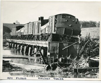
... plain. Records say that "The brown floodwater stain in Bass Strait could be seen from passing airliners." Considerable damage was done to railway infrastructure, roads and farms. ...plain. Records say that "The brown floodwater stain in Bass Strait could be seen from passing airliners." Considerable damage was done to railway infrastructure, roads and farms. ...The 1971 flood was the the worst flood on record. At Jarrahmond it was at least 11 metres and up to one and a half kilometres wide on the flats causing enormous damage to the flood plain. Records say that "The brown floodwater stain in Bass Strait could be seen from passing airliners." Considerable damage was done to railway infrastructure, roads and farms. More information from the APRIL, 2008 newsletter by John Phillips. (see orbosthistory.com.au) The railway line was destroyed and was not expected to be opened for a fortnight. Orbost was cut off by 50 square miles of Snowy River floodwater. This train was being shunted across the viaduct when waters smashed through washing away several trucks sending the crew running for their lives.This is pictorial evidence of a significant local event. It is connected to the history of the railway in East Gippsland.A large black / white photograph of flooded railway yards with a train engine stranded on a small section of track surrounded by water and debris.on front - "1971 Flood, Railway Yards"floods-1971-orbost orbost-railway natural-disasters-orbost -
 Orbost & District Historical Society
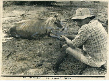
black and white photograph, 11 February 1971
... plain. Records say that "The brown floodwater stain in Bass Strait could be seen from passing airliners." Considerable damage was done to railway infrastructure, roads and farms. ...plain. Records say that "The brown floodwater stain in Bass Strait could be seen from passing airliners." Considerable damage was done to railway infrastructure, roads and farms. ...This photograph was taken during the 1971 floods at Orbost. The 1971 flood was the the worst flood on record. At Jarrahmond it was at least 11 metres and up to one and a half kilometres wide on the flats causing enormous damage to the flood plain. Records say that "The brown floodwater stain in Bass Strait could be seen from passing airliners." Considerable damage was done to railway infrastructure, roads and farms. More information from the APRIL, 2008 newsletter by John Phillips. (see orbosthistory.com.au)This is a contemporary pictorial record of a significant local event.A large black / white photograph of a man, dressed in shorts and a checked shirt, sitting on a fence post surrounded by mud. He is holding on to the leg of a cow which is stuck in the mud.on front - "Mr Harrison on Tracey's Dairy" on back - " Herald 11 Feb 1971"floods-orbost-1971 tracey-dairy natural-disaster-flood -
 Orbost & District Historical Society
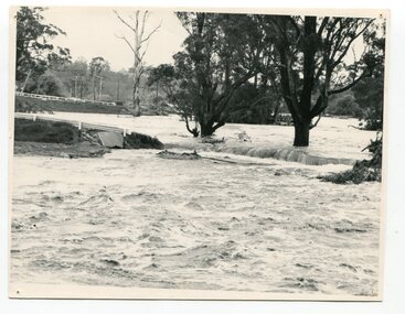
black and white photograph, February, 1971
... plain. Records say that "The brown floodwater stain in Bass Strait could be seen from passing airliners." Considerable damage was done to railway infrastructure, roads and farms. ...plain. Records say that "The brown floodwater stain in Bass Strait could be seen from passing airliners." Considerable damage was done to railway infrastructure, roads and farms. ...This photograph shows the floodwaters during the 1971 flood at Orbost. The two mahogany trees in the photograph stopped the Snowy River from changing its course. The 1971 flood was the the worst flood on record. At Jarrahmond it was at least 11 metres and up to one and a half kilometres wide on the flats causing enormous damage to the flood plain. Records say that "The brown floodwater stain in Bass Strait could be seen from passing airliners." Considerable damage was done to railway infrastructure, roads and farms. More information from the APRIL, 2008 newsletter by John Phillips. (see orbosthistory.com.au)This is a pictorial record of a significant event in the history of floods in Orbost.A black / white photograph of raging floodwaters at the bottom of the Orbost township.orbost-flood-1971 -
 Flagstaff Hill Maritime Museum and Village
Photograph - Portrait, David Charles McArthur, Superintendent, Bank of Australasia 1867-1876
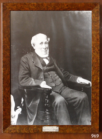
... Road BoA Union Bank Australia & New Zealand Bank ANZ Bank David Charters McArthur D C McArthur Lower left corner "A-H 1-9". Engraved on plaque "DAVID CHARTERS MCARTHUR \ SUPERINTENDENT \ BANK OF AUSTRALASIA \ 1867-1876" Photograph; portrait of David Charteris McArthur. Heavily retouched black and white print in plain brown ...The subject of this photograph, David Charteris McArthur, was the founding manager of the Bank of Australasia in Port Phillip (Melbourne). McArthur was born in 1808 in Gloucester, England, and educated in Scotland. He worked for an insurance firm in Edinburgh, where in 1835 he married Caroline, nee Wright. McArthur and his family party sailed from the U.K. to arrive in Sydney in October 1835, where he joined the Bank of Australasia when it opened in Sydney in December. McArthur sailed to Melbourne in August 1838 with 3000 pounds in coins, protected by armed guards and two bulldogs, to open the Melbourne branch of the Bank of Australasia. The branch grew quickly, servicing both private and government customers. He opened many branches in the goldfields during the 1850s. In 1862, he was appointed as general inspector of branches. He spent time with the bank in New Zealand. On his return to Melbourne, at age 57, he was put in charge of the entire bank. McArthur lived in the hills of Heidelberg, Melbourne. He was the first chairman of Associated Banks and was an advisor to politicians and merchants. He was retired in October 1876 by the London directors and given a free trip to London, an annuity and a seat on the bank’s Advisory Board. McArthur was active in the community, being a member of the Mechanics’ Institute, on the committee that advised Governor Hotham on the Colony’s finances, chairman of the Heidelberg Road Board, one of the original trustees of the Library of Victoria in 1853 and president of the trustees of the Public Library, Museums and National Gallery of Victoria in 1880-83. He was also on many other community organisations. He died in his home “Charterisville” in East Ivanhoe in 1887. He and Caroline had no children. The Melbourne branch of Australia and New Zealand Bank has a portrait of McArthur in its boardroom. St John's Church, Heidelberg, commemorates him with a stained-glass window entitled 'King David'. The McArthur Gallery in the National Gallery of Victoria is also named after him. (David's brother, Donald, moved from Sydney to Melbourne in 1836 with the first government survey team.) ABOUT THE BANK OF AUSTRALASIA In 1836 the Bank of Australasia was established in London by Royal Charter. In 1951 the bank merged with the Union Bank of Australia, to form ANZ Bank Limited. In 1970 it merged with the English, Scottish and Australian Bank to become Australia and New Zealand Banking Group Limited. Since that time the ANZ has acquired other banks and introduced Internet banking and mobile banking. BANK OF AUSTRALASIA IN WARRNAMBOOL The Bank of Australasia first opened in Warrnambool in July 1854 in a building on Merri Street. The manager was Mr Samuel Hannaford. The bank then purchased and moved to a stone building on the corner of Timor and Gibson Streets, previously owned by Cramond and Dickson and almost opposite the Examiner’s office. In January 1957 Mr W.H. Palmer became the new manager and was there until November 1869. The bank then built its own building on the corner of Timor and Kepler Streets in 1859. Mr Basil Spence, the teller, was appointed acting manager in 1869 and Mr H.B. Chomley was the next appointed manager, in April 1873 and was still manager in 1886. The municipality of Warrnambool first banked with the Bank of Australasia from 1856 to April 1857. David Charteris McArthur served as the founding manager of the Bank of Australasia. His leadership marked a significant chapter in Warrnambool's early commercial development. The municipality of Warrnambool relied on the Bank of Australasia as its official bank from 1856 until April 1857. This period is symbolised by a photograph of McArthur, which represents the origins of Warrnambool's commercial history and its early financial infrastructure.Photograph; portrait of David Charteris McArthur. Heavily retouched black and white print in plain brown varnished frame, behind glass, with plaque on lower edge and inscription lower left corner.Lower left corner "A-H 1-9". Engraved on plaque "DAVID CHARTERS MCARTHUR \ SUPERINTENDENT \ BANK OF AUSTRALASIA \ 1867-1876"flagstaff hill, warrnambool, shipwrecked-coast, flagstaff-hill, flagstaff-hill-maritime-museum, maritime-museum, shipwreck-coast, flagstaff-hill-maritime-village, bank of australasia, david charteris mcarthur, superintendent bank of australasia, colonial commerce, manager bank of australasia melbourne, colonial bank, warrnambool bank of australasia, shipwrecked coast, flagstaff hill maritime museum, maritime museum, shipwreck coast, flagstaff hill maritime village, great ocean road, boa, union bank, australia & new zealand bank, anz bank, david charters mcarthur, d c mcarthur -
 Flagstaff Hill Maritime Museum and Village
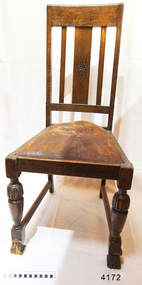
Furniture - Chair, ca 1944
... Flagstaff Hill Maritime Museum and Village Flagstaff Hill Warrnambool Maritime Museum Maritime Village Shipwreck Coast Great Ocean Road Religion Religious service St Nicholas Seamen’s Church Williamstown Missions to Seamen Victoria religious furniture chair wooden chair Chair wooden dark brown with curved back rest, one of a set of three. The 2 front legs are decoratively shaped (turned) while the back legs are plain ...This chair, one of a set of three, was part of the original furnishings of the St Nicholas' Mission to Seamen's Church at 139 Nelson Place, Williamstown, Victoria. The Church was operated by the Mission to Seamen organisation. This chair, one of three, is significant historically for its origin in the St Nicholas Mission to Seamen's Church in Williamstown, established in 1857 to cater for the physical, social, and spiritual needs of seafarers. It originated in Bristol, England when a Seamen's Mission was formed in 1837. Chair wooden dark brown with curved back rest, one of a set of three. The 2 front legs are decoratively shaped (turned) while the back legs are plain and flat-sided. Almost square flat seat. Part of the St Nicholas Seamen's Church collection.flagstaff hill maritime museum and village, flagstaff hill, warrnambool, maritime museum, maritime village, shipwreck coast, great ocean road, religion, religious service, st nicholas seamen’s church, williamstown, missions to seamen victoria, religious furniture, chair, wooden chair -
 Flagstaff Hill Maritime Museum and Village
Furniture - Chair, ca 1944
... Flagstaff Hill Maritime Museum and Village Flagstaff Hill Warrnambool Maritime Museum Maritime Village Shipwreck Coast Great Ocean Road Religion Religious service St Nicholas Seamen’s Church Williamstown Missions to Seamen Victoria chair religious furniture Chair wooden dark brown with curved backrest, one of a set of three. The two front legs are decoratively shaped (turned) while the back legs are plain ...This chair, one of a set of three, is significant historically for its origin in the St Nicholas Mission to Seamen's Church in Williamstown, established in 1857 to cater for the physical, social, and spiritual needs of seafarers. It originated in Bristol, England when a Seamen's Mission was formed in 1837. Chair wooden dark brown with curved backrest, one of a set of three. The two front legs are decoratively shaped (turned) while the back legs are plain and flat-sided. Almost square flat seat.flagstaff hill maritime museum and village, flagstaff hill, warrnambool, maritime museum, maritime village, shipwreck coast, great ocean road, religion, religious service, st nicholas seamen’s church, williamstown, missions to seamen victoria, chair, religious furniture -
 Flagstaff Hill Maritime Museum and Village
Furniture - Chair, ca. 1944
... Flagstaff Hill Maritime Museum and Village Flagstaff Hill Warrnambool Maritime Museum Maritime Village Shipwreck Coast Great Ocean Road Religion Religious service St Nicholas Seamen’s Church Williamstown Missions to Seamen Victoria chair religious furniture dining chair church furniture religious worship Anglican Church worship service Mission to Seafarers St Nicholas Missions to Seamen’s Church Williamstown Missions to Seamen St Nicholas Missions to Seamen’s Church Flagstaff Hill 139 Nelson Place Williamstown Chair, dark brown wood, curved backrest. One of a set of three. The two front legs are decoratively shaped (turned), while the back legs are plain ...This chair, one of a set of three, was part of the original furnishings of the St Nicholas' Mission to Seamen's Church at 139 Nelson Place, Williamstown, Victoria. The Church was operated by the Mission to Seamen organisation. THE MISSIONS TO SEAMEN (Brief History: for more, see our Reg. No. 611, Set of Pews) The Missions to Seamen was an Anglican charity that served seafarers of the world since 1856 in Great Britain. It symbol is a Flying Angel, inspired by a Bible verse. Today there are centres in over 200 ports worldwide where seamen of all backgrounds are offered a warm welcome and provided with a wide range of facilities. In Victoria, the organisation began in Williamstown in 1857 as a Sailors’ Church, also known as ‘Bethel’ or the ‘Floating Church’ in an old hulk floating in Hobson’s Bay, Port of Melbourne. It soon became part of the Missions to Seamen, Victoria. In the year 2000 the organisation, now named Mission to Seafarers, still operated locally in Melbourne, Portland, Geelong and Hastings. The Ladies’ Harbour Lights Guild was formed in 1906 to support the Missions to Seamen in Melbourne and other centres such as Williamstown. Two of the most significant ladies of the Guild were founder Ethel Augusta Godfrey and foundation member Alice Sibthorpe Tracy (who established a branch of the Guild in Warrnambool in 1920). The Guild continued its work until the 1960s. In 1943 a former Williamstown bank was purchased for the Missions to Seaman Club. The chapel was named St Nicholas’ Seamen’s Church and was supported by the Ladies’ Harbour Lights Guild, the Williamstown Lightkeepers’ Auxiliary and the League of Soldiers’ and Sailors’ Friends. It ceased operation in 1966. A Missions to Seamen Chapel and Recreation Room was a significant feature of ports during the late 1800s and into the 1900s. It seemed appropriate for Flagstaff Hill to include such a representation within the new Maritime Village, so the Melbourne Board of Management of Missions to Seamen Victoria gave its permission on 21st May 1979 for the entire furnishings of the Williamstown chapel to be transferred to Flagstaff Hill. The St Nicholas Seamen’s Church was officially opened on October 11, 1981, and closely resembles the Williamstown chapel. This chair is historically significant for its origin in the St Nicholas Mission to Seamen's Church in Williamstown, established in 1857 to cater for the physical, social, and spiritual needs of seafarers. The organisation originated in Bristol, England, when a Seamen's Mission was formed in 1837. Chair, dark brown wood, curved backrest. One of a set of three. The two front legs are decoratively shaped (turned), while the back legs are plain and flat-sided. It has an almost square flat seat. This chair is part of the St Nicholas Seamen's Church Collection. flagstaff hill maritime museum and village, flagstaff hill, warrnambool, maritime museum, maritime village, shipwreck coast, great ocean road, religion, religious service, st nicholas seamen’s church, williamstown, missions to seamen victoria, chair, religious furniture, dining chair, church furniture, religious worship, anglican church, worship service, mission to seafarers, st nicholas missions to seamen’s church williamstown, missions to seamen, st nicholas missions to seamen’s church flagstaff hill, 139 nelson place williamstown -
Coal Creek Community Park & Museum
Milk Jug
... Coal Creek Community Park & Museum 12 Silkstone Road Korumburra gippsland Made in Japan. Patent No. 10481 Brown striped milk jug with plain brown handle and blue and white picture in a circle on the front. ...Brown striped milk jug with plain brown handle and blue and white picture in a circle on the front.Made in Japan. Patent No. 10481 -
 Wodonga & District Historical Society Inc
Photograph - Wodonga Herald, Issue No. 1, Wodonga Herald, April 19, 1873
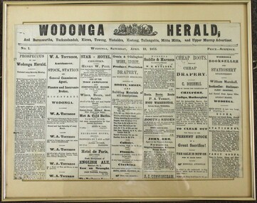
... Road Bonegilla the-murray The establishment of the "Wodonga Herald" was an attempt to create a publication to cater to the needs of the growing local township of Wodonga and the surrounding townships. The proponents of the publication aimed to promote the area and its interests on a wider scale at the same time as the railways were extending into the district. It was intended for circulation in Wodonga as well as Barnawartha, Yackandandah, Kiewa, Towong, Koetong, Tallangatta, Mitta Mitta and the Upper Murray as well as Chiltern, Brown's Plains ...The establishment of the "Wodonga Herald" was an attempt to create a publication to cater to the needs of the growing local township of Wodonga and the surrounding townships. The proponents of the publication aimed to promote the area and its interests on a wider scale at the same time as the railways were extending into the district. It was intended for circulation in Wodonga as well as Barnawartha, Yackandandah, Kiewa, Towong, Koetong, Tallangatta, Mitta Mitta and the Upper Murray as well as Chiltern, Brown's Plains. Rutherglen, Wahgunyah, Albury and its vicinity. The publication did not meet is objectives and folded on 4 October 1873. The "Murray and Hume Times" was founded as its successor. It was published in Wodonga and Albury on Tuesdays and Fridays and circulated through the whole of the Murray and Hume Districts. The place the new publication was printed seems to have fluctuated between a printing office in Dean Street, Albury, and the main printing office in Sydney Street, Wodonga. By June 1874 the "Murray and Hume Times" had also run into financial difficulties. In October 1874, only one year after its launch the second paper changed hands to the owner of the Albury Banner, George Adams. This item is significant as it represents one of the earliest newspaper publications for the Wodonga district.A photo of the front page of the first issue of the Wodonga Herald published in Wodonga on Saturday, April 19, 1873. Price Sixpence. The image has been mounted with a card backing in a metal frame. The publication included circulation to Barnawartha, Yackandandah, Kiewa, Towong, Tintaldra, Koetong, Tallangatta, Mitta Mitta and Upper Murray Advertiser.wodonga herald, early wodonga newspapers, the murray and hume times, the albury banner, george adams publisher -
 Whitehorse Historical Society Inc.
Ceramic - Tile
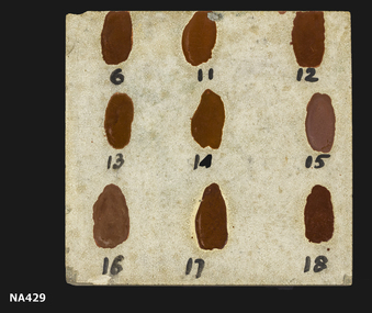
... Whitehorse Historical Society Inc. 2-10 Deep Creek Road Mitcham melbourne ceramics earthenware (Handwritten on back) 25 Blythe Plain ceramic tile used for brown coloured glazes numbered 6,11,12,13,14,15,16,17,18 Ceramic Tile ...Plain ceramic tile used for brown coloured glazes numbered 6,11,12,13,14,15,16,17,18(Handwritten on back) 25 Blytheceramics, earthenware -
 Whitehorse Historical Society Inc.
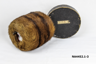
Accessory - Fur Muff and Box, 1920s
... Whitehorse Historical Society Inc. 2-10 Deep Creek Road Mitcham melbourne This plain brown fur muff was worn by Miss Emma Louise Foreman in the mid 1920s, and later when she married Mr Elrick Tait, who owned a factory in Prahran which manufactured wooden tool handles. costume accessories glove accessories Brown round fur muff, lined with red satin material in original round box with lid. ...This plain brown fur muff was worn by Miss Emma Louise Foreman in the mid 1920s, and later when she married Mr Elrick Tait, who owned a factory in Prahran which manufactured wooden tool handles.Brown round fur muff, lined with red satin material in original round box with lid.costume accessories, glove accessories -
 Whitehorse Historical Society Inc.
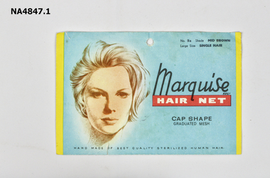
Headwear - Hairnets assorted
... Road Mitcham melbourne costume accessories hair accessories .1 Marquise hairnet envelope blue with face (empty) No 5, Shade mid brown large size single hair, cap shape.|.2 Embassy 2 pack, white with red writing on cellophane packet. Slumber net for medium light brown. Rayon and nylon|.3 Surefit, Human hair cap net, yellow with black writing on cellophane packet|.4 'Ideal' cap net human hair light brown. Manilla envelope.|.5 'Ideal' cap net human hair light brown , plain ....1 Marquise hairnet envelope blue with face (empty) No 5, Shade mid brown large size single hair, cap shape.|.2 Embassy 2 pack, white with red writing on cellophane packet. Slumber net for medium light brown. Rayon and nylon|.3 Surefit, Human hair cap net, yellow with black writing on cellophane packet|.4 'Ideal' cap net human hair light brown. Manilla envelope.|.5 'Ideal' cap net human hair light brown , plain envelopecostume accessories, hair accessories