Showing 126 items matching "burkes bridges"
-
 Eltham District Historical Society Inc
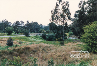
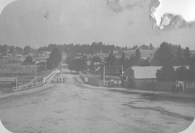
Photograph, Burkes Bridge, Hurstbridge
... burkes bridges...Colour photograph showing the old and new Burkes Bridges over Arthurs Creek, Hurstbridge...Eltham District Historical Society Inc 728 Main Rd Eltham melbourne burkes bridges bridges hurstbridge hurstbridge arthurs creek road arthurs creek road arthurs creek Colour photograph showing the old and new Burkes Bridges over Arthurs Creek, Hurstbridge Burkes Bridge, Hurstbridge Photograph ...Colour photograph showing the old and new Burkes Bridges over Arthurs Creek, Hurstbridgeburkes bridges, bridges, hurstbridge, hurstbridge arthurs creek road, arthurs creek road, arthurs creek -
 Kew Historical Society Inc
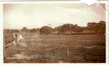
Photograph - Yarra Flats near Burke Road Bridge, 1937
... Yarra Flats near Burke Road Bridge...Original, black and white positive print of what is said to be the Yarra Flats near Burke Road Bridge. On the horizon, building can be seen, whereas in the middle ground, farm fencing and a windmill are the main features as well as remnant Eucalypts. ...Inscribed verso: "Yarra Flats near Burke Rd Bridge 1937" ...Inscribed verso: "Yarra Flats near Burke Rd Bridge 1937" Original, black and white positive print of what is said to be the Yarra Flats near Burke Road Bridge. ...Land along the Yarra River in Kew is now either designated open space, parkland or public golf links. By the 1930s much of this area remained open farmland, bought at auction for dairy farming in the 1840s.Original, black and white positive print of what is said to be the Yarra Flats near Burke Road Bridge. On the horizon, building can be seen, whereas in the middle ground, farm fencing and a windmill are the main features as well as remnant Eucalypts. Inscribed verso: "Yarra Flats near Burke Rd Bridge 1937" studley park -- kew (vic.) -
 Eltham District Historical Society Inc
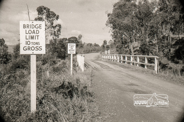
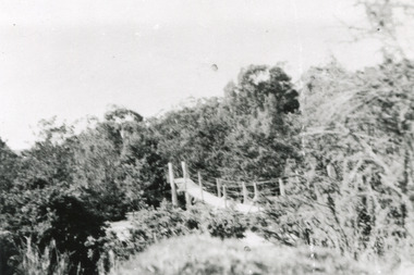
Negative - Photograph, Russell Yeoman, Burkes Bridge, Hurstbridge, c.1970
... Old Burkes Bridge over Arthurs Creek....Eltham District Historical Society Inc 728 Main Rd Eltham melbourne Old Burkes Bridge over Arthurs Creek. bridge bridges arthurs creek Hurstbridge burkes bridge Ilford HP4 Roll of 35mm black and white negative film, 4 of 7 strips Burkes Bridge, Hurstbridge Negative Photograph Russell Yeoman ...Old Burkes Bridge over Arthurs Creek.Roll of 35mm black and white negative film, 4 of 7 stripsIlford HP4bridge, bridges, arthurs creek, hurstbridge, burkes bridge -
 Kew Historical Society Inc
Photograph, Burke Road Bridge, 1930s
... Burke Road Bridge...burke road bridge (kew)...Private and public bridges were constructed from the 1850s, beginning with the Hawthorn Bridge linking Bridge and Burwood Roads. A bridge across the Yarra at Burke Road was created as early as 1873. ...Sepia, faded photograph of the Burke Road Bridge linking East Kew and Ivanhoe. The previous bridge, constructed in 1926 was submerged beneath the flood waters in the 1934 mega-flood of the Yarra....Since that first wooden bridge, a number of later bridges, typically on concrete pylons have been built, in 1926 and again during the 1970s. burke road bridge (kew) bridges -- river yarra Sepia, faded photograph of the Burke Road Bridge linking East Kew and Ivanhoe. ...Without bridges, Kew remained cut off from the City of Melbourne, only being accessible by Punt. Private and public bridges were constructed from the 1850s, beginning with the Hawthorn Bridge linking Bridge and Burwood Roads. A bridge across the Yarra at Burke Road was created as early as 1873. Since that first wooden bridge, a number of later bridges, typically on concrete pylons have been built, in 1926 and again during the 1970s.Sepia, faded photograph of the Burke Road Bridge linking East Kew and Ivanhoe. The previous bridge, constructed in 1926 was submerged beneath the flood waters in the 1934 mega-flood of the Yarra.burke road bridge (kew), bridges -- river yarra -
 Kew Historical Society Inc
Archive (Sub-series) - Subject File, Bridges (Kew), 1958-present
... Bridges referred to and described in the file include Kanes Bridge, Walmer Street Foot Bridge, Johnston Street Bridge, Chandler Bridge, Collins Bridge, Tramway or Zig Zag Bridge, Penny Toll Bridge, Victoria Street Bridge, Burke Road Bridge. The file includes original materials relating to the Victoria Street Bridge Centenary Celebration 1884-1984. ...Bridges referred to and described in the file include Kanes Bridge, Walmer Street Foot Bridge, Johnston Street Bridge, Chandler Bridge, Collins Bridge, Tramway or Zig Zag Bridge, Penny Toll Bridge, Victoria Street Bridge, Burke Road Bridge. The file includes original materials relating to the Victoria Street Bridge Centenary Celebration 1884-1984. ...Various partiesReference, Research, InformationSecondary Values (KHS Imposed Order)Subject file containing information relating to each of the bridges crossing the Yarra In Kew. The file includes correspondence, photocopied photographs and maps, journal articles, research, and printed ephemera. Bridges referred to and described in the file include Kanes Bridge, Walmer Street Foot Bridge, Johnston Street Bridge, Chandler Bridge, Collins Bridge, Tramway or Zig Zag Bridge, Penny Toll Bridge, Victoria Street Bridge, Burke Road Bridge. The file includes original materials relating to the Victoria Street Bridge Centenary Celebration 1884-1984 -
 Kew Historical Society Inc
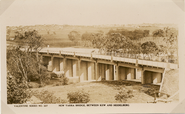
Postcard, Valentine Publishing Co Pty Ltd, New Yarra Bridge, Between Kew and Heidelberg, 1926-1930
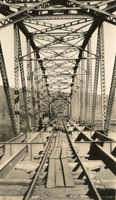
... burke road bridge - kew (vic)...Private and public bridges were constructed from the 1850s, beginning with the Hawthorn Bridge linking Bridge and Burwood Roads. A bridge across the Yarra at Burke Road was created as early as 1873. ...Angle view of the new Yarra bridge [ie. The Burke Road bridge] taken from the Kew side, showing the bridge’s structure. ...The Burke Road bridge] taken from the Kew side, showing the bridge’s structure. ...Without bridges, Kew remained cut off from the City of Melbourne, only being accessible by Punt. Private and public bridges were constructed from the 1850s, beginning with the Hawthorn Bridge linking Bridge and Burwood Roads. A bridge across the Yarra at Burke Road was created as early as 1873. Since that first wooden bridge, a number of later bridges, typically on concrete pylons have been built, in 1926 and again during the 1970s.Angle view of the new Yarra bridge [ie. The Burke Road bridge] taken from the Kew side, showing the bridge’s structure. Trees line the river’s edge. In the distance can be seen a distant line of houses stretching to the horizon. The river appears to have an S-shaped bend beyond the bridge. The postcard, No. 227, was produced by the Valentine Publishing Co. Pty Ltd., of Queen Street, Melbourne.burke road bridge - kew (vic), bridges - kew (vic) -
Kew Historical Society Inc
Plan - Charteris Estate, Ivanhoe [East], 1927
... In addition to the overall plan spread across pages 2 and 3, each page includes a number of interesting photographs including: a number of the new Burke Road Bridge, a sports ground, Hoyts Picture Theatre in Ivanhoe, a croquet ground, and Ivanhoe shopping centre [named Motor Cross Junction]....In addition to the overall plan spread across pages 2 and 3, each page includes a number of interesting photographs including: a number of the new Burke Road Bridge, a sports ground, Hoyts Picture Theatre in Ivanhoe, a croquet ground, and Ivanhoe shopping centre [named Motor Cross Junction]. ...Subdivision plans and real estate flyers/brochures reveal a number of aspects of urban development and history. The Kew Historical Society's collection of these plans, as well as advertisements extracted from magazines, cover key aspects of community development and architectural history of Kew and Kew Eat as well as surrounding suburbs. While most of the plans in the collection were gifted to the Society by the former City of Kew, a number of other plans and advertisements have been donated by individuals, of which this is an example.Original 4-page bifold handout advertising 43 residential lots for sale in the Charteris Estate subdivision in Ivanhoe [now classified as Ivanhoe East]. This brochure was created to sell the third section of the estate which it labels as 'The Most Superb Section'. Streets within the subdivision include: Burke Road North, McArthur Road, Castella Street, and the Government Boulevard. In addition to the overall plan spread across pages 2 and 3, each page includes a number of interesting photographs including: a number of the new Burke Road Bridge, a sports ground, Hoyts Picture Theatre in Ivanhoe, a croquet ground, and Ivanhoe shopping centre [named Motor Cross Junction].charteris estate - east ivanhoe (vic), subdivision plans -- ivanhoe east (vic.), d.c. mcarthur, charterisville -
 Eltham District Historical Society Inc
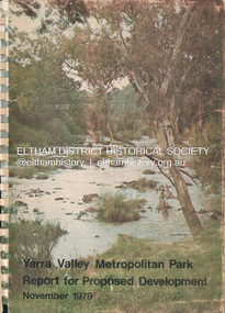
Book, Melbourne Metropolitan Board of Works, Yarra Valley Metropolitan Park : report for proposed development : a recreation, conservation and landscape planning study for the Melbourne and Metropolitan Board of Works, Metropolitan Parks Division / by Scott and Furphy Engineers Pty Ltd, Landscape Division, November 1979
... Parklands comprise about 1700 hectares or about 4200 acres of land extending from Burke Road Bridge to Pound Bend, Warrandyte. The consultants (Scott and Furphy Engineers Pty Ltd, Landscape Division) were directed to investigate all recreation, conservation and landscape aspects which would have direct visual, environmental or regional recreation bearing on the proposed parkland. ...Parklands comprise about 1700 hectares or about 4200 acres of land extending from Burke Road Bridge to Pound Bend, Warrandyte. The consultants (Scott and Furphy Engineers Pty Ltd, Landscape Division) were directed to investigate all recreation, conservation and landscape aspects which would have direct visual, environmental or regional recreation bearing on the proposed parkland. ...In August 1976, MMBW commissioned Consultants to provide comprehensive planning services for the preparation of a Plan for the development of the Yarra Valley Metropolitan Park, the proposed Park is a linear corridor surrounded by the Heidelberg and Eltham communities to the north; the Camberwell, Doncaster and Templestowe and Warrandyte communities are located to the south. Parklands comprise about 1700 hectares or about 4200 acres of land extending from Burke Road Bridge to Pound Bend, Warrandyte. The consultants (Scott and Furphy Engineers Pty Ltd, Landscape Division) were directed to investigate all recreation, conservation and landscape aspects which would have direct visual, environmental or regional recreation bearing on the proposed parkland. Their final report is published bearing in mind that the development of the Yarra Valley Metropolitan Park must occur over a long span of time. melbourne metropolitan board of works, yarra river, yarra river valley, yarra valley metropolitan park -
 Kew Historical Society Inc
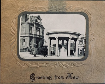
Postcard, Greetings from Kew, c.1928
... Individual postcards include: Studley Park Road, River Yarra showing new Bridge [Chandler Hwy], High Street showing soldier's memorial, River Yarra at Victoria Bridge, The Yarra at Studley Park, Holy Trinity Church, the [Alexandra] Gardens, New Yarra Bridge [Burke Rd], Soldiers' Memorial and Post Office Kew...Individual postcards include: Studley Park Road, River Yarra showing new Bridge [Chandler Hwy], High Street showing soldier's memorial, River Yarra at Victoria Bridge, The Yarra at Studley Park, Holy Trinity Church, the [Alexandra] Gardens, New Yarra Bridge [Burke Rd], Soldiers' Memorial and Post Office Kew Greetings from Kew Postcard ...An item from an outstanding and diverse photographic collection, assembled by members of the Christian and Washfold families of Kew.Rae series of postcards, otherwise unknown, showing important sites in KewSmall folding postcard including nine black and white postcard views of Kew. Cover depicts Kew War Memorial set within an embossed cardboard frame. Individual postcards include: Studley Park Road, River Yarra showing new Bridge [Chandler Hwy], High Street showing soldier's memorial, River Yarra at Victoria Bridge, The Yarra at Studley Park, Holy Trinity Church, the [Alexandra] Gardens, New Yarra Bridge [Burke Rd], Soldiers' Memorial and Post Office Kewwashfold family, christian-washfold collection, postcards -- kew (vic.) -
 Kew Historical Society Inc
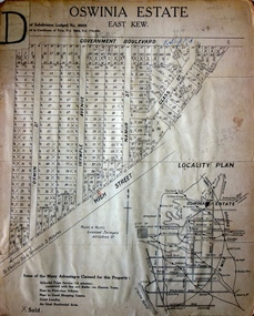
Plan - Subdivision Plan, Oswinia Estate, East Kew, c.1925
... When the subdivision plan was created, it included the proposed bridge over the Yarra at Burke Road. The bridge was to be officially opened in 1926....When the subdivision plan was created, it included the proposed bridge over the Yarra at Burke Road. The bridge was to be officially opened in 1926. ...Prue Sanderson, in her groundbreaking ‘City of Kew Urban Conservation Study : Volume 2 - Development History’ (1988), summarised the periods of urban development and subdivisions of land in Kew. The periods that she identified included 1845-1880, 1880-1893, 1893-1921, 1921-1933, 1933-1943, and Post-War Development. These periods were selected as they represented periods of rapid growth or decline in urban development. An obvious starting point for Sanderson’s groupings involved population growth and the associated economic cycles. These cycles also highlighted urban expansion onto land that was predominantly rural, although in other cases it represented the decline and breakup of large estates. A number of the plans in the Kew Historical Society’s collection can also be found in other collections, such as those of the State Library of Victoria and the Boroondara Library Service. A number are however unique to the collection.Subdivision plans are historically important documents used as evidence of the growth of suburbs in Australia. They frequently provide information about when the land was sold on which a built structure was subsequently constructed as well as evidence relating to surveyors and real estate and financial agents. The numerous subdivision plans in the Kew Historical Society's collection represent working documents, ranging from the initial sketches made in planning a subdivision to printed plans on which auctioneers or agents listed the prices for which individual lots were sold. In a number of cases, the reverse of a subdivision plan in the collection includes a photograph of a house that was also for sale by the agent. These photographs provide significant heritage information relating house design and decoration, fencing and household gardens.The ‘Oswinia Estate’ subdivision in East Kew was planned and auctioned in the first half of the 1920s. 169 allotments were created in the triangular section of land bordered by High Street, Burke Road and the Government Boulevard (later Kilby Road). The only piece of land excluded was that where the previous Kew Pound had been located at the east tip of the triangle. Allotments were created fronting Glass, High, Namur, Oswin Streets, Irymple Avenue, and the Government Boulevard. The name for the Estate was derived from Oswin’s farm, which had been one of the largest landholdings in East Kew. The selling agents annotated the plan in our collection with crosses indicating those lots that had been sold. The inset locality plan is particularly interesting as it shows the route and stations of the Outer Circle Railway. When the subdivision plan was created, it included the proposed bridge over the Yarra at Burke Road. The bridge was to be officially opened in 1926.subdivision plans - east kew, oswinia estate, high street, glass street, namur street, government boulevard - kilby road, irymple street, oswin street -
Kew Historical Society Inc
Archive (Sub-series) - Subject File, Kew Historical Society, Gardens (Kew), 1979
... She refers to: the pear trees planted by William Oswin in c. 1845 near what is now the Burke Road Bridge (she notes that a search for the trees at the time of the construction of the Eastern Freeway was unsuccessful), a camellia planted by the Dannocks near the corner of Derby and High Street, a c.1876 pine tree in Field Place, Henty Court, an 1875 Moreton Bay fig at Tarring, Ruyton, a Moreton Bay fig at Roxeth, Trinity Grammar, an 1840s oak tree and a 120-year old olive tree at Fairholme, Barry Street, 1870 pine trees at D’Estaville, Barry Street, trees at Turinville, Barnard Grove, dating to 1846, pine trees dating from 1845-6 on the Willsmere Farm, red gums in Victoria Park, pine trees in the Cemetery dating from the 1860s, trees in the Alexandra Gardens and at Kew Primary School, palm trees at La Verna, Sackville Street dating from the 1890s, the trees and gardens at Ross House (Charleville), and the trees at Merridale, Sackville Street which date from the 1880s, a magnolia at Lalla Rookh. ...She refers to: the pear trees planted by William Oswin in c. 1845 near what is now the Burke Road Bridge (she notes that a search for the trees at the time of the construction of the Eastern Freeway was unsuccessful), a camellia planted by the Dannocks near the corner of Derby and High Street, a c.1876 pine tree in Field Place, Henty Court, an 1875 Moreton Bay fig at Tarring, Ruyton, a Moreton Bay fig at Roxeth, Trinity Grammar, an 1840s oak tree and a 120-year old olive tree at Fairholme, Barry Street, 1870 pine trees at D’Estaville, Barry Street, trees at Turinville, Barnard Grove, dating to 1846, pine trees dating from 1845-6 on the Willsmere Farm, red gums in Victoria Park, pine trees in the Cemetery dating from the 1860s, trees in the Alexandra Gardens and at Kew Primary School, palm trees at La Verna, Sackville Street dating from the 1890s, the trees and gardens at Ross House (Charleville), and the trees at Merridale, Sackville Street which date from the 1880s, a magnolia at Lalla Rookh. ...Various partiesReference, Research, InformationSecondary Values (KHS Imposed Order)Correspondence and newspaper articles/clippings relating to historic gardens in Kew. The oldest item is a letter from the National Trust Victoria announcing their two-year garden study and seeking information on gardens in Kew. Mavis Rolley, Secretary of the Society, made handwritten notes in response, which are kept in the file. She refers to: the pear trees planted by William Oswin in c. 1845 near what is now the Burke Road Bridge (she notes that a search for the trees at the time of the construction of the Eastern Freeway was unsuccessful), a camellia planted by the Dannocks near the corner of Derby and High Street, a c.1876 pine tree in Field Place, Henty Court, an 1875 Moreton Bay fig at Tarring, Ruyton, a Moreton Bay fig at Roxeth, Trinity Grammar, an 1840s oak tree and a 120-year old olive tree at Fairholme, Barry Street, 1870 pine trees at D’Estaville, Barry Street, trees at Turinville, Barnard Grove, dating to 1846, pine trees dating from 1845-6 on the Willsmere Farm, red gums in Victoria Park, pine trees in the Cemetery dating from the 1860s, trees in the Alexandra Gardens and at Kew Primary School, palm trees at La Verna, Sackville Street dating from the 1890s, the trees and gardens at Ross House (Charleville), and the trees at Merridale, Sackville Street which date from the 1880s, a magnolia at Lalla Rookh. These dates are probably highly contestable. Other handwritten notes from 1979 about significant gardens included: 5 Molesworth Street, Red Bluff - Redmond Street (garden now destroyed), Campion House, Studley Park Road, Raheen, Studley Park Road, Ross House, Cotham Road (Charleville), 7 Adeney Avenue, 20-21 Belmont Avenue, 52 Mary Street, an Edna Walling garden on the corner of Argyle Road and Victor Avenue, Merridale, Sackville Street, Roseneath, and Reno, St John’s Parade.gardens - private - kew (vic), garden design - kew (vic), kew horticultural societygardens - private - kew (vic), garden design - kew (vic), kew horticultural society -
 Federation University Historical Collection
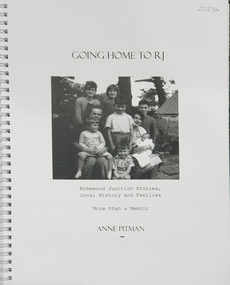
Book, Anne Pitman, Going Home to RJ: Rokewood Junction Stories, Local History and Families: More than a Memoir, 2023
... Bridge...Illabrook...Conereyalk...Woady Yalloak Creek...Mt Misery Creek...Paddy's Gully Diggings....Dereel...pitfield...Wadawurrung...William rutland...squatters...Aborigines...Aboriginal...Charlotte Walsh...Maurice Walsh...Julie Pitman...Ben Liston...sheep and wool...George Hawkins...Natthew Wakeling...Christopher Moody...mt misery goldfield...John Bower...Mary Bower...Hyslop's Hotel...Cumberland Store...Jane Hyslop...edward Collyer...Jospeh Gladstone...Lucas's Bakery...Henry Batty...William Young...Ellen Rigby...chinese...Joseph Anguey...Eliza Anguey...Murder of Thomas Ulick Burke...Bridge Illabrook Conereyalk Woady Yalloak Creek Mt Misery Creek Paddy's Gully Diggings. Dereel pitfield Wadawurrung William rutland squatters Aborigines Aboriginal Charlotte Walsh Maurice Walsh Julie Pitman Ben Liston sheep and wool George Hawkins Natthew Wakeling Christopher Moody mt misery goldfield John Bower Mary Bower Hyslop's Hotel Cumberland Store Jane Hyslop edward Collyer Jospeh Gladstone Lucas's Bakery Henry Batty William Young Ellen Rigby chinese Joseph Anguey Eliza Anguey Murder of Thomas Ulick Burke William Achultze William Schiltze Nicholas grenfell Tomas Bramley murder Emily Malhoff drowning Ah Lin Eliza Richards Luisa Bupell Eleanor Holmes Rachel Holmes Joseph Holloway Noah Holloway Thomas Faulkner Robert Eli HEarn George Todhunter Briggs John Robinson Fairweather Rokewood Common Edward Bussell Louisa Bussell Irving Rachinger john chatham Doris Chatham Peter Chatham Jack Chatham Imogen Chatham Domenico Rizzoli Mary Rizzoli Rokewood Junction Railway Line Illabrook Football and Netball Club Cape Clear Red Cross keith Annear Fire brigade Rokewood Junction Post Office Len Aarons Dereel Pre-emptive Right Rokewood Junction Avenue of Honour arthur chatham Beverley Chatham ( daughter of Arthur Chatham) suggested that Commerlghip refers to Watering holes and underground springs found in the Little Woady Yallok and Mt Misery Creeks. ...Beverley Chatham ( daughter of Arthur Chatham) suggested that Commerlghip refers to Watering holes and underground springs found in the Little Woady Yallok and Mt Misery Creeks. Rokewood Junction was proclaimed a township in 1885, originally known as a gold-mining township called Paddy's Gully Diggings.Ringbound publication of 212 pagesnon-fictionBeverley Chatham ( daughter of Arthur Chatham) suggested that Commerlghip refers to Watering holes and underground springs found in the Little Woady Yallok and Mt Misery Creeks. Rokewood Junction was proclaimed a township in 1885, originally known as a gold-mining township called Paddy's Gully Diggings. rokewood, rokewood junction, chatham, kurus-a-ruc, henry pitman, elizabeth pitman, william henry pitman, rokewood junction state school, commeralghip, paddy's gully bridge, illabrook, conereyalk, woady yalloak creek, mt misery creek, paddy's gully diggings., dereel, pitfield, wadawurrung, william rutland, squatters, aborigines, aboriginal, charlotte walsh, maurice walsh, julie pitman, ben liston, sheep and wool, george hawkins, natthew wakeling, christopher moody, mt misery goldfield, john bower, mary bower, hyslop's hotel, cumberland store, jane hyslop, edward collyer, jospeh gladstone, lucas's bakery, henry batty, william young, ellen rigby, chinese, joseph anguey, eliza anguey, murder of thomas ulick burke, william achultze, william schiltze, nicholas grenfell, tomas bramley murder, emily malhoff, drowning, ah lin, eliza richards, luisa bupell, eleanor holmes, rachel holmes, joseph holloway, noah holloway, thomas faulkner, robert eli hearn, george todhunter briggs, john robinson fairweather, rokewood common, edward bussell, louisa bussell, irving rachinger, john chatham, doris chatham, peter chatham, jack chatham, imogen chatham, domenico rizzoli, mary rizzoli, rokewood junction railway line, illabrook football and netball club, cape clear, red cross, keith annear, fire brigade, rokewood junction post office, len aarons, dereel pre-emptive right, rokewood junction avenue of honour, arthur chatham -
 Eltham District Historical Society Inc
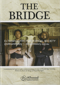
Booklet - Program, Keira de Hoog et al, The Bridge; a community-led open play commemorating 100 years of Hurstbridge township, September 2024
... Bridge performance at Hurstbridge was by members of the Allwood Neighbourhood House and the Hurstbridge Community. To commemorate 100 years of Hurstbridge township, the production was led by local historian David Kerrigan who co-wrote the play with Keira de Hoog. The quiet life of the Diamond Creek district was shattered on the 4th October 1866 when a visitor arrived seeking food and shelter. What followed has become part of the Hurstbridge story. The death of Henry Hurst by the bushranger Robert Burke...Bridge performance at Hurstbridge was by members of the Allwood Neighbourhood House and the Hurstbridge Community. To commemorate 100 years of Hurstbridge township, the production was led by local historian David Kerrigan who co-wrote the play with Keira de Hoog. The quiet life of the Diamond Creek district was shattered on the 4th October 1866 when a visitor arrived seeking food and shelter. What followed has become part of the Hurstbridge story. The death of Henry Hurst by the bushranger Robert Burke ...Program produced as part of the open air play peformed in Hurstbridge twice on the 4th and 12th of October 2024. Contents include: Allwood history - Allwood today - Construction of The Bridge - Cast - Synopsis - Directors - Crew - Hearfelt thanks and tribute to Pam Lawson. The Premiere of the open air play The Bridge performance at Hurstbridge was by members of the Allwood Neighbourhood House and the Hurstbridge Community. To commemorate 100 years of Hurstbridge township, the production was led by local historian David Kerrigan who co-wrote the play with Keira de Hoog. The quiet life of the Diamond Creek district was shattered on the 4th October 1866 when a visitor arrived seeking food and shelter. What followed has become part of the Hurstbridge story. The death of Henry Hurst by the bushranger Robert Burke and the subsequent inquest, trial and execution of Burke captured the attention of the nation. News of the event was reported nationally and in UK newspapers. Rain at sunset on opening night set the scene for the sombre story which opened with clap sticks and imagery as part of the acknowledgement of country. Attention to detail in Act One included the enactment of writing a letter that Ellen Hurst had actually written back to her family in England, days before the incident, which set the scene – and choreography of the “capture” of Burke immediately following the shooting as drawn by the engraver Robert Bruce and published in 1866. The cast, crew and audience moved around the actual physical site the altercation took place till the final act and judgement of Sir Redmond Barry to execute Burke. The souvenir program given to ticket holders includes photos and biographies of the cast taken in costume at Gulf Station, Yarra Glen, together with background information and the narrative of the play. Guests on opening night – 158 years ago to the day of the event included Dianne Switzer, descendent of pioneer Cornelius Hailley and Rob Fergusson, descendent of Henry Hurst. plays, hurstbridge, allwood neighbourhood house -
 Eltham District Historical Society Inc
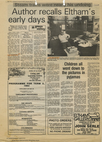
Folder, John Handfield
... Bridge...Tessie Baker...Walter Withers...Burke...Copeland Edward Gadd Ernest James Andrew Fanny Withers (nee Flinn) Hubert Rutter Jack Baker Jack Ryan June Rutter Margery Withers Newsagency Oakley Ronnie Baker Silver Street Bridge Tessie Baker Walter Withers Burke and Wills Father G K Tucker Frederick Oliver Handfield Friends and Brothers (book) Muriel Elizabeth Handfield (nee Cochran) SS Victoria St Laurence and Community Aid Abroad Stanhope House Theodore Louis Hopton Handfield Book review Folder of information on John Handfield, author, Eltham John Handfield Folder ...1. News clipping: Author recalls Eltham's early days; story by Linley Hartley, photo by Ron Grant; Diamond Valley News, Thursday, May 24, 1983, p26 (On reverse side, p25, "A pot for every purpose" about potter Joan Armfield with references to artis Davd Armfield) 2. Three pages typed copy of John Handfield's original letter to Blanche Shallard (of the Shire of Eltham Historical Society), 16 May 1989 detailing the Handfield family's life in Eltham and various personalities between their arrival in 1919 and departure in 1928. With a postscript that John Handfield returned in 1961 to a house designed by friend Robin Boyd and built 1961. At the time of the letter John and Esta Handfield had been the only owners. 3. Note from John Handfield to Ron Smith about a proposed talk (to the Historical Society?) to tell the story about the writing of Friends and Brothers. Proposed title of talk "You Never Know What's Around The Corner" plus several copies of book reviews • Photocopy of news clipping; The rector who created a vision; Review by Bishop Holland; Newcastle Morning Herald, c.1980 - Book review of FRIENDS AND BROTHERS, The Life of Father Tucker, Founder of the Brotherhood of St Laurence and Community Aid Abroad, by John Handfield, Hyland House Publishing Pty Ltd • Photocopy of news clipping; The clergyman whose monuments continue to do good; Review by Geoffrey Hutton; Publication unknown, c.1980 - Book review of FRIENDS AND BROTHERS, The Life of Father Tucker, Founder of the Brotherhood of St Laurence and Community Aid Abroad, by John Handfield, Hyland House Publishing Pty Ltd • Photocopy of news clipping; Helper of the defeated; Review by Sandy Murray; Publication unknown, c.1980 - Book review of FRIENDS AND BROTHERS, The Life of Father Tucker, Founder of the Brotherhood of St Laurence and Community Aid Abroad, by John Handfield, Hyland House Publishing Pty Ltd • Photocopy of news clipping; Friends and Brothers by John Handfield; Review by Bishop James Grant; Publication unknown, c.1980 - Book review of FRIENDS AND BROTHERS, The Life of Father Tucker, Founder of the Brotherhood of St Laurence and Community Aid Abroad, by John Handfield, Hyland House Publishing Pty Ltd • Photocopy of news clipping; Off and running on his third career by Stuart Sayers; Writers & Readers, The Age, Saturday 17 January 1981 • Photocopy of news clipping; Determined to succeed; Review by Roy Cassin; The West Australian, n.d. - Book review of FRIENDS AND BROTHERS, The Life of Father Tucker, Founder of the Brotherhood of St Laurence and Community Aid Abroad, by John Handfield, Hyland House Publishing Pty LtdFolder of information on John Handfield, author, Elthamjohn handfield, joan armfield, david armfield, handfield family, eltham, 16 homestead road, handfield house, anne hunniford, dave lyon, esta handfield, mechanics insitute, mr bond, rechabite hall, robin boyd, rutter family, bishop reginald stephen, clem christesen, desmond annear, dr kent hughes, ethel boake, handfield street, john harcourt, kooringoorama, lady longstaff, nina christesen, peter street, shillinglaw farm, sir john longstaff, stanhope, yarra braes, a. copeland, alf baker, baker's cottage, ballakian, belackian, beulah alice rutter, bill withers, bird brothers cash grocer and fruiterer, blacksmith, burgoyne grocery store, butcher, david rutter, donald rutter, e. copeland, edward gadd, ernest james andrew, fanny withers (nee flinn), hubert rutter, jack baker, jack ryan, june rutter, margery withers, newsagency, oakley, ronnie baker, silver street bridge, tessie baker, walter withers, burke and wills, father g k tucker, frederick oliver handfield, friends and brothers (book), muriel elizabeth handfield (nee cochran), ss victoria, st laurence and community aid abroad, stanhope house, theodore louis hopton handfield, book review -
 Eltham District Historical Society Inc
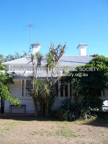
Photograph - Digital Photograph, Alan King, Allwood House, Hurstbridge, 16 April 2008
... bridge across the creek near his house, after which Hurstbridge was named. He ran the property helped by two ticket-of-leave men and others, several of whom were sailors who had abandoned ship in search of gold, and were working there temporarily. In 1866, only 14 years after coming to Australia, Hurst met an early tragic death. One day a bushranger named Burke...bridge across the creek near his house, after which Hurstbridge was named. He ran the property helped by two ticket-of-leave men and others, several of whom were sailors who had abandoned ship in search of gold, and were working there temporarily. In 1866, only 14 years after coming to Australia, Hurst met an early tragic death. One day a bushranger named Burke ...Allwood - built in 1894 by Henry Hurst’s relatives, stands near the site of his house, which was demolisherd in the 1940s. Until 1924 Hurstbridge was known as Allwood. The building, one of the district's oldest is situated back from the corner of Arthurs Creek Road and Main Road. Covered under Heritage Overlay, Nillumbik Planning Scheme Published: Nillumbik Now and Then / Marguerite Marshall 2008; photographs Alan King with Marguerite Marshall.; p17 Hurst, who was a surveyor, came to Melbourne in 1852 by default, as on the way to Sydney he contracted typhoid and was off-loaded in Melbourne. Deciding to settle near Melbourne, he selected some land near the present Eltham railway station and was one of the first to grow crops there.2 But disaster struck again, when his shack was looted and burned, while he was carting goods for sale to nearby goldfields. It was then that Hurstbridge’s first settler, Cornelius Haley, asked Hurst to manage his 160 acres (65ha) grazing property and 9000 acres (3443ha) of leased land where the present Hurstbridge stands. Hurst proved equal to the tough conditions and he and his brother, Fred, cut a track with a bullock team from the property to Romsey, where Haley had selected some land. Hurst also put up a bridge across the creek near his house, after which Hurstbridge was named. He ran the property helped by two ticket-of-leave men and others, several of whom were sailors who had abandoned ship in search of gold, and were working there temporarily. In 1866, only 14 years after coming to Australia, Hurst met an early tragic death. One day a bushranger named Burke came to the house and demanded a horse. Hurst thought the bushranger might be an officer in search of runaway sailors3 and anyway, did not like the look of him, so he refused. A tussle followed and apparently Hurst shot first.4 He was shot and died five hours later from loss of blood. Later, troopers found Burke, who was subsequently hanged. The event is recorded in the Old Melbourne Gaol. The government offered the family £500 but the family refused it as ‘blood money’. Hurst’s father, Robert, even signed a petition against the bushranger’s death, claiming one life did not replace another. Hurst’s family continued to live in the district and saw a rise in their fortunes. They bought Haley’s cattle station and built the present Allwood House, using the original home as an orchard packing shed. The present Victorian style timber house had several outbuildings including a blacksmith’s shop. The property passed on to William Gray, an orchardist and nurseryman, who married Hurst’s grandniece, Frances. The business boomed from the early 1900s when it supplied most of the orchards in the area. Gray was Eltham Shire’s President for two terms and was asked to stand for parliament, but his wife’s illness and other family commitments prevented him from doing so. Then several calamities drove the family to bankruptcy. During World War One, Gray lost more than one million pounds on trees shipped overseas, which the Lloyd’s company had refused to insure. Other factors, including the Great Depression, ruined the family’s fortunes. The land was reduced from more than 640 acres (256ha) to 50 acres (20ha) and the older members married and left. After Mr Gray died, the house was leased, until his daughter Sheila Ferguson and her husband Gordon settled there in 1951, after buying it from other family members. However in 1975 the Shire designated the property as a passive recreation reserve. The Ferguson family sold most of the land, leaving the house on 0.6 hectares.This collection of almost 130 photos about places and people within the Shire of Nillumbik, an urban and rural municipality in Melbourne's north, contributes to an understanding of the history of the Shire. Published in 2008 immediately prior to the Black Saturday bushfires of February 7, 2009, it documents sites that were impacted, and in some cases destroyed by the fires. It includes photographs taken especially for the publication, creating a unique time capsule representing the Shire in the early 21st century. It remains the most recent comprehenesive publication devoted to the Shire's history connecting local residents to the past. nillumbik now and then (marshall-king) collection, hurstbridge, henry hurst, allwood house -
 Bendigo Historical Society Inc.
Document - LONG GULLY HISTORY GROUP COLLECTION: THE BENDIGO POST OFFICE
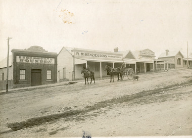
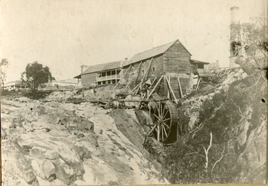
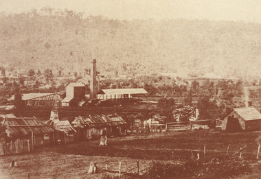
... Burke and Wills Expedition... Sandhurst Hotel... Courthouse... Hiberian... The Freemasons... The Courthouse... The Commercial Law Courts... The Hamburg... The European... The Prince Bismark... The Lord Kitchener... The Bendigo... The Rosalind Park... The Showgrounds... Atheneum Club... Olivers... Bridge...History House 11 Mackenzie Street Bendigo goldfields BENDIGO History long gully history group The Long Gully History Group - The Bendigo Post Office L C Bennetts Mt Alexander Post Office Porcupine Inn Cenotaph Pike or Pyke Baby Health Centre Sandhurst Post Office Government Survey Office Queen Elizabeth Oval Sandhurst Trustees Company Mr H B Briston Savings Bank Telegraph Office The Sub-Treasury Sir Henry Brougham Lock KCB Sir John Nimmo MLA Prince of Wales group of mines The New Prince of Wales Eaglehawk Golf Links New Prince of Wales No 2 The Whip and Jersey Mines Department Lansell's Big 180 New Chum and Victoria Mine and Battery New Chum Railway Koch's Pioneer South New Moon Catherine Reef United New Moon The Virginia South Bell Vue Central Nell Gwynne North Nell Gwynne Miner's Phthisis Hercules Engine House Ironbark New Chum Syncline Hercules Energetic Roberts & Sons Harkness & Co Horwoods Great Southern Ulster Carlisle Lansells Big 180 Victoria Quartz New St Mungo Duchess Tribute South Devonshire Hopewell Mine Saxby Mine McNair & Co Shamrock Mr King Burke and Wills Expedition Sandhurst Hotel Courthouse Hiberian The Freemasons The Courthouse The Commercial Law Courts The Hamburg The European The Prince Bismark The Lord Kitchener The Bendigo The Rosalind Park The Showgrounds Atheneum Club Olivers Bridge Hotel Bourkes The Globe The Hibernia Albert Albion Abbotts Australian Belvidere Beehive British Queen Black Eagle British and American Brian Boru Bakers Arms Butchers Arms Brick Layers Arms Bull and Mouth Cresent Clarence Back Creek Bridge Cape Clear Crooked Billet Cambridgeshire Arms Camp Coach and Horses Cricketers Arms Diggers Rest Ellesmere Five Lions Franklyn Golden Square Golden Gate Golden Gully Golden Age Golden Vine Gumtree Glasgow Reef Great Britain Haymarket Daniel O'Connell Half Way House Fleece Inn Ironbark Johnsons Reef Lancashire Live and Let Live Manchester Arms Gold Mines Metropolitan Crown National New Chum Honeysuckle Street Pavilion Napier Arms Quartz Miners Arms Retreat Inn Rainbow Rose of Australia Lake View Robin Hood Fountain Southern Cross Bath Berlin Spring Gully Star Sir Charles Hotham Silvermines Royal Oak Suburban Town Hall Temperance Ship Inn View Point View Bend Victoria Exchange American Arcade Belfast All Nations Union United Kingdom Union Jack Westend Washington Waterloo Wellington Whitehorse Wheat Sheaf Yorkshire Niagra Noahs Ark Article titled The Bendigo Post Office, compiled by L C Bennetts. ...Article titled The Bendigo Post Office, compiled by L C Bennetts. Mentioned is the history of the Bendigo Post Office and postmarks, some information on mining, Bendigo foundries, Underground connections of mines, expenses and shaft sinking costs. Also mentioned is Bendigo and Eaglehawk - 60 years ago and the role the pubs played in daily living. They were where theatres, concerts and dances were held, and the meeting rooms for clubs and lodges, even church benefits. Listed is a number of Bendigo hotels. Some even had a few names. Names of the pubs are: The Freemasons, The Courthouse, The Commercial Law Courts, The Hamburg, The European, The Prince Bismark, The Lord Kitchener, The Bendigo, The Rosalind Park, The Showgrounds, Atheneum Club, Olivers, Bridge Hotel, Bourkes, The Globe, The Hibernia, Albert, Albion, Abbotts, Australian, Belvidere, Beehive, British Queen, Black Eagle, British and American, Brian Boru, Bakers Arms, Butchers Arms, Brick Layers Arms, Bull and Mouth, Cresent, Clarence, Back Creek Bridge, Cape Clear, Crooked Billet, Cambridgeshire Arms, Camp, Coach and Horses, Cricketers Arms, Diggers Rest, Ellesmere, Five Lions, Franklyn, Golden Square, Golden Gate, Golden Gully, Golden Age, Golden Vine, Gumtree, Glasgow Reef, Great Britain, Haymarket, Daniel O'Connell, Half Way House, Fleece Inn, Ironbark, Johnsons Reef, Lancashire, Live and Let Live, Manchester Arms, Gold Mines, Metropolitan, Crown, National, New Chum, Honeysuckle Street, Pavilion, Napier Arms, Quartz Miners Arms, Retreat Inn, Rainbow, Rose of Australia, Lake View, Robin Hood, Fountain, Southern Cross, Bath, Berlin, Spring Gully, Star, Sir Charles Hotham, Silvermines, Royal Oak, Suburban, Town Hall, Temperance, Ship Inn, View Point, View Bend, Victoria, Exchange, American, Arcade, Belfast, All Nations, Union, United Kingdom, Union Jack, Westend, Washington, Waterloo, Wellington, Whitehorse, Wheat Sheaf, Yorkshire, Niagra and Noahs Ark.bendigo, history, long gully history group, the long gully history group - the bendigo post office, l c bennetts, mt alexander post office, porcupine inn, cenotaph, pike or pyke, baby health centre, sandhurst post office, government survey office, queen elizabeth oval, sandhurst trustees company, mr h b briston, savings bank, telegraph office, the sub-treasury, sir henry brougham lock kcb, sir john nimmo mla, prince of wales group of mines, the new prince of wales, eaglehawk golf links, new prince of wales no 2, the whip and jersey, mines department, lansell's big 180, new chum and victoria mine and battery, new chum railway, koch's pioneer, south new moon, catherine reef united, new moon, the virginia, south bell vue, central nell gwynne, north nell gwynne, miner's phthisis, hercules engine house, ironbark, new chum syncline, hercules energetic, roberts & sons, harkness & co, horwoods, great southern, ulster, carlisle, lansells big 180, victoria quartz, new st mungo, duchess tribute, south devonshire, hopewell mine, saxby mine, mcnair & co, shamrock, mr king, burke and wills expedition, sandhurst hotel, courthouse, hiberian, the freemasons, the courthouse, the commercial law courts, the hamburg, the european, the prince bismark, the lord kitchener, the bendigo, the rosalind park, the showgrounds, atheneum club, olivers, bridge hotel, bourkes, the globe, the hibernia, albert, albion, abbotts, australian, belvidere, beehive, british queen, black eagle, british and american, brian boru, bakers arms, butchers arms, brick layers arms, bull and mouth, cresent, clarence, back creek bridge, cape clear, crooked billet, cambridgeshire arms, camp, coach and horses, cricketers arms, diggers rest, ellesmere, five lions, franklyn, golden square, golden gate, golden gully, golden age, golden vine, gumtree, glasgow reef, great britain, haymarket, daniel o'connell, half way house, fleece inn, ironbark, johnsons reef, lancashire, live and let live, manchester arms, gold mines, metropolitan, crown, national, new chum, honeysuckle street, pavilion, napier arms, quartz miners arms, retreat inn, rainbow, rose of australia, lake view, robin hood, fountain, southern cross, bath, berlin, spring gully, star, sir charles hotham, silvermines, royal oak, suburban, town hall, temperance, ship inn, view point, view bend, victoria, exchange, american, arcade, belfast, all nations, union, united kingdom, union jack, westend, washington, waterloo, wellington, whitehorse, wheat sheaf, yorkshire, niagra, noahs ark -
 The Beechworth Burke Museum
Photograph, 1910
... The Beechworth Burke Museum Loch Street Beechworth high-country Taken in 1910, this photograph depicts a scene of Bridge road in Newtown, Beechworth. ...Taken in 1910, this photograph depicts a scene of Bridge road in Newtown, Beechworth. Walking on the road are two men on horseback, one of which is pulling a carriage with a small dog standing beside it. Behind them are a line of small buildings and shops. Small industries began to expand dramatically in Beechworth, particularly during the 1860s, leading to a strengthening of the towns economy. As early as 1853, areas surrounding the waterway known as Spring Creek were surveyed with the intent of mapping out plans for new roads and building allotments. Land was sold and new buildings were erected, creating an expansion of the Beechworth township and retail services. One building shown in this photograph is Straughair and Duncan's Beechworth Foundry. This business was established in 1858 through the partnership of Mark Straughair and John Duncan. It dealt mostly in the manufacturing of castings and mining machinery, receiving orders from all over the Ovens district. The Business eventually collapsed after the deaths of Straughair in 1882 and Duncan in 1896 but was reopened by W.H. Phillips in 1905. The two other buildings are both associated with the name McKenzie. Evidence suggests that the McKenzie family has a long association with the town of Beechworth. This photograph is historically significant as it provides insight into the nineteenth and twentieth century industrial expansions that happened in the area of Newtown, leading to the urbanisation of Beechworth. Black and white rectangular photograph printed on matte photographic paper mounted on card.Reverse: Newton / 1997.2648 / 33 Newton Beechworth / 84-219-1 / McKenzies / BMM3055 / newtown beechworth, bridge road, 1910, j. duncan, r. mckenzie, m. straughair, industrial growth, ford street, beechworth foundry, straughair and duncan, mckenzie and sons grainstore, mckenzie family store -
 The Beechworth Burke Museum
Photograph, 1859
... Reverse: 3146 / 1997.2654 / Louis Chevalier's Flour Mill on / the Newtown Falls before the / Bridge / Est 1853 / this photo 1859 / 84-229-1 / Burke Museum Beechworth / Page 41 / 81 % / (Illegible) / (Illegible) 14 / ...The mill race and wheel are also clearly depicted, which may shed light onto how mill wheels of this era and place were constructed Chevalier Louis Chevalier Newtown Mill Grain Mill sawmill flour mill 1850s Beechworth Beechworth Council Farming and agriculture Victorian agricultural history Spring Creek buildings industry forestry Wood Timber Reverse: 3146 / 1997.2654 / Louis Chevalier's Flour Mill on / the Newtown Falls before the / Bridge / Est 1853 / this photo 1859 / 84-229-1 / Burke Museum Beechworth / Page 41 / 81 % / (Illegible) / (Illegible) 14 / Black and white rectangular photograph printed on matte photographic paper mounted on board Photograph Photograph ...Louis Chevalier, brother of popular artist Nicholas Chevalier, opened a sawmill in Beechworth near Spring Creek in Newtown in 1853. This facilitated a boom in building in the town, as materials were much more available than they had been previously. A second sawmill was opened in the town in 1856. Louis Chevalier served on the Beechworth Council as a representative of Newtown between 1858 and 1860. As this photograph is taken in 1859, the mill would have been operating as a sawmill at the time this photograph was taken. Louis Chevalier’s mill stopped sawing wood and began milling flour at some point between 1860 and 1862. At this time, the Oven’s district was almost self-sufficient, producing considerable quantities of grain, dairy, fodder and meat. Unfortunately, the region experienced poor agricultural yields in the 1880s and 1890s, which lead to the closure of the Beechworth Flour Mills in the 1880s. This photograph depicts the first sawmill in Beechworth, which was responsible for making the materials available for other early buildings in the town. The mill race and wheel are also clearly depicted, which may shed light onto how mill wheels of this era and place were constructedBlack and white rectangular photograph printed on matte photographic paper mounted on boardReverse: 3146 / 1997.2654 / Louis Chevalier's Flour Mill on / the Newtown Falls before the / Bridge / Est 1853 / this photo 1859 / 84-229-1 / Burke Museum Beechworth / Page 41 / 81 % / (Illegible) / (Illegible) 14 / chevalier, louis chevalier, newtown, mill, grain mill, sawmill, flour mill, 1850s beechworth, beechworth council, farming and agriculture, victorian agricultural history, spring creek, buildings, industry, forestry, wood, timber -
 The Beechworth Burke Museum
Photograph, est. 1860-1875
... bridge on the Wangaratta side. Completed in 1880 it was declared to be one of the greatest engineering feats in Australia. The tunnel is still basically intact today. / Series by Wooragee Graphics: Historic Beechworth. / COPYRIGHT BURKE MUSEUM / No.72 ...bridge on the Wangaratta side. Completed in 1880 it was declared to be one of the greatest engineering feats in Australia. The tunnel is still basically intact today. / Series by Wooragee Graphics: Historic Beechworth. / COPYRIGHT BURKE MUSEUM / No.72 A sepia rectangular photograph printed on matte photographic paper as a postcard Photograph Photograph ...In 1875, the Rocky Mountain Extended Gold Sluicing Company Ltd was created, utilising the previous Rocky Mountain claim for the area near Lake Sambell. The company employed A.L Martin to survey an area for a tunnel underneath Beechworth and Johnson Stephens to dig it. The tunnel was built at a rate of 40 feet a month and eventually measured 800 metres. The tunnel was a true accomplishment both in the present and during the 19th century. It was considered to be a marvelous engineering feat. Beechworth is renowned for its hydraulic sluice method of mining. This involved soil being exposed to torrents of water from high-pressure hoses. From 1876 until its closure in 1921, the mine produced an astounding 47,926 ozs of gold. Companies like this were the source of income for many Chinese gold-diggers who sought to make their fortune on the goldfields of Beechworth. During the height of the rush, the town had around 7,000 Chinese inhabitants living on the outskirts of town as they were not permitted to live within Beechworth itself.The search for gold is ingrained into the history of Victoria and therefore, images like this one which portrays an open-cut sluicing site can reveal important information for society and technology for the date when the photograph was taken. This image is of important historical significance for its ability to convey information about sluicing and the methods used to find gold in 1910. It also shows a location where sluicing was undertaken which provides insight into the impact of sluicing on the environment at a time when it was done. This image of the Rocky Mountain mine is historically significant as the mining complex is now non-existent, with the only remains being the tunnel built in 1880 by the company, which was considered one of the greatest engineering feats of the time. The image also provides a first-hand look into the social and cultural networks at play during the 19th century with racial segregation of the Chinese at the 'Chinese Camp', as well as an insight into Beechworth's origins during the Gold Rush.A sepia rectangular photograph printed on matte photographic paper as a postcardReverse: Historic Beechworth / 7792.1 / ROCKY MOUNTAIN MINE / Viewed from the “Chinese Camp”, shown partly in the foreground, we see the central plant of the famous Rocky Mountain Mining Company. This extensive complex, of which nothing remains, was situated between Silver Creek and the present Lake Sambell area. The company was responsible for a tunnel cut through solid bedrock underneath the town of Beechworth and surfacing near the keystone bridge on the Wangaratta side. Completed in 1880 it was declared to be one of the greatest engineering feats in Australia. The tunnel is still basically intact today. / Series by Wooragee Graphics: Historic Beechworth. / COPYRIGHT BURKE MUSEUM / No.72 beechworth, rocky mountain mine, sluicing, gold rush, mining, gold -
 The Beechworth Burke Museum
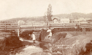
Postcard, c. Early 1900s
... The Beechworth Burke Museum Loch Street Beechworth high-country Taken in the early 1900s, the postcard depicts two girls dressed in old style, white knee length dress which was common for this period for young women. This compared to the ankle length styles which were acceptable for adult women. We can also see an example of early bridge ...Taken in the early 1900s, the postcard depicts two girls dressed in old style, white knee length dress which was common for this period for young women. This compared to the ankle length styles which were acceptable for adult women. We can also see an example of early bridge construction and engineering, notably made from timber rather than from stone or steel, noted in the postcard as Snow's Bridge. Sepia rectangular postcard printed on card Obverse: Snow's Bridge/Beechworth Reverse: Dear Julie/ I received your pretty PB/ We haven't gone away yet. Mr Stokes/ asked me were you going to be/ married. He wished you luck/ (I wonder/ if he meant it.) We sent the Magpie to Annie to-day. I haven't got any/ word about going to a [unknown]/ yet. We had a great Friendly Societies/ day yesterday but it rained a bit/ Sally is going to get a [illegible] silk/ dress. When are you to be married?/ Mr Pounceby is back at Allen's shop./ [unknown]. We are going to Belle's for a [unknown] if we can. With Love from Lilly. bridge, beechworth, snow's bridge, children, childhood, postcard -
 The Beechworth Burke Museum
Photograph, Unknown. After 1890
... The Beechworth Burke Museum Loch Street Beechworth high-country Early photo of the Bridge over Spring Creek taken along Camp Street facing East. ...Early photo of the Bridge over Spring Creek taken along Camp Street facing East. This photograph was taken after 1890, when powerlines were beginning to be put up in regional Victoria.Black and white rectangular photograph printed on matte photographic paperbeechworth, spring creek, camp street -
 The Beechworth Burke Museum
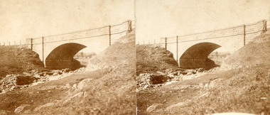
Photograph - Stereoscopic Photograph, Unknown c1875
... The Beechworth Burke Museum Loch Street Beechworth high-country Depicted in the photograph is Newtown Bridge or the Newtown Falls Bridge, in Beechworth, Victoria. ...Depicted in the photograph is Newtown Bridge or the Newtown Falls Bridge, in Beechworth, Victoria. Noted for its location, detailed craftsmanship and stonemasonry by Scottish stonemasons the Newtown Bridge was built in the 19th century provincial town of Beechworth (completed in 1875). The bridge was built over Spring Creek, spanning 6.3 meters wide and 24.8 meters tall. Beechworth held a distinct role in the administrative and commercial management of Victoria's north-eastern goldfields, with many objects and structures still well preserved from the towns establishment. The bridge indicates the growth of the town, replacing a previous timber structure as well as its association to the mining activity in the area and the rapid increase in Australia's economy that led to investment and development of roads and railways. The local granite used in the construction of the single arch Newtown Bridge makes the bridge and other buildings made with the granite unique to the area, the honey-toned material distinct to Beechworth. This photograph is historically significant as it provides insight into the industrial development of Beechworth and the surrounding area, contributed to by the goldfields. The photograph further captures the representation of vernacular engineering traditions and Scottish stonemasonry.Two sepia-toned rectangular photographs featuring a bridge in the background printed on matte photographic paper mounted on card.Reverse: 97.2324/ Newtown Bridge/ Beechworthbridge, newtown beechworth, newtown bridge, newtown, beechworth, beechworth falls bridge, beechworth mining district, spring creek, -
 The Beechworth Burke Museum
Photograph
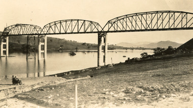
... The Beechworth Burke Museum Loch Street Beechworth high-country Taken between 1928 and 1930, depicted is the Bethanga Bridge under construction. ...Taken between 1928 and 1930, depicted is the Bethanga Bridge under construction. The Bridge was completed in 1930 and was built to assist residents of the Bethanga district to travel to Albury. Other bridges would become submerged by the backed-up water of the Murray and Mitta Rivers so the Bethanga bridge was built two miles above the Mitta Weir. The Bethanga Bridge was built north of the future Hume Dam which would be completed in 1936. At 2430 feet long, Bethanga Bridge was the longest road bridge in Australia at the time of its completion. The Bridge is 20 feet wide and made up of nine 270 feet long spans. Materials used include ten tons of paint for the steel works; 1600 tons of steel; 900 tons of timber for the decking; and reinforced concrete for the piers. The tender for the construction was awarded to C. Ruwolt Pty. Ltd., engineers who were located on Victoria Street, West Richmond. The contract was awarded for £71,890. It was predicted between 250 and 300 men would find employment on the project. The news was well received by trade unions at the time as there had been a drop in available engineering work.This photograph is historically significant as it depicts the progress of the Bethanga Bridge construction, which was important infrastructure for the area. It is also a good example of methods used in the area to assist in travel over the river prior to the construction of the Hume Dam.Black and white rectangular photo printed on matte photographic paper.Reverse: 1997 3186 / 84-19-3 / This is the bridge. / It is not yet open to traffic / yet. will not be completed / until May next / It is a wonderful bridge the / pillars are 100 feet high. / KODAK PRINT Envelope Obverse: Peterson PHOTO / Hume Weir Envelope Reverse: BMM 84-20-1,2+3. bethanga bridge, lake hume, hume dam, hume weir, murray river, bridge, bethanga, albury -
 The Beechworth Burke Museum
Geological specimen - Feldspathic Sandstone
... bridges, and in buildings, both commercial and residential. This specimen is part of a larger collection of geological and mineral specimens collected from around Australia (and some parts of the world) and donated to the Burke Museum between 1868-1880. ...Feldspathic arenites are sandstones that contain less than 90% quartz, and more feldspar than unstable lithic fragments, and minor accessory minerals.Feldspathic sandstones are commonly immature or sub-mature.These sandstones occur in association with cratonic or stable shelf settings. Feldspathic sandstones are derived from granitic-type, primary crystalline, rocks. If the sandstone is dominantly plagioclase, then it is igneous in origin Sandstone features prominently in public buildings throughout Victoria. Most of the sandstone used as dimension stone in the State came from three sources: the Heatherlie quarry in the Grampians (Silurian), the Bacchus Marsh area (Permian), and the Barrabool Hills near Geelong (Cretaceous).Sandstone features prominently in public buildings throughout Victoria, making this specimen special as it shows the materials used by Victorian building companies. Sandstone can also be crushed, crushed stone is used in the construction of roadways and road structures such as bridges, and in buildings, both commercial and residential. This specimen is part of a larger collection of geological and mineral specimens collected from around Australia (and some parts of the world) and donated to the Burke Museum between 1868-1880. A large percentage of these specimens were collected in Victoria as part of the Geological Survey of Victoria that begun in 1852 (in response to the Gold Rush) to study and map the geology of Victoria. Collecting geological specimens was an important part of mapping and understanding the scientific makeup of the earth. Many of these specimens were sent to research and collecting organisations across Australia, including the Burke Museum, to educate and encourage further study. A feldspar-rich sandstone, a sandstone intermediate in composition between an arkosic sandstone and a quartz sandstone, containing 10% to 25% feldspar and less than 20% matrix material of clay, sericite, and chlorite. Feldspathic arenite containing less than 90 percent of the composition of quartz. Feldspar is the main composition. Feldspathic arenite may contain fragments of unstable rock, and a little amount of other minerals such as mica and heavy minerals. Some feldspathic arenite have pink or red color because of the presence of potassium feldspar or iron oxide. There are also colored light gray to white. These sandstones are usually medium to coarse grained and can contain a high percentage of granules with angular until subangular roundness. The content of the matrix can appear as the rest up to more than 15 percent, and sorting of grains can present as moderate to poorly sorted. Feldspathic sandstones are generally immature in textural maturity. Feldspathic arenite can not be judged from the structure of the sediment. Bedding can emerge from the laminate parallel to the crossbed. Fossils may appear in the layer deposited on the sea. Feldspathic arenites usually appear on the craton or the continental shelf, which can be associated with conglomerate, quartz lithic arenite, carbonate rock, or evaporites. This sandstone may also appear on the succession of sedimentary basins deposited on an unstable or deep sea, and moving arc setting. According to Pettijohn (1963) Arkose make up about 15 percent of all sandstones. Some Arkose formed in situ when the granite and related rocks disintegrate and generate granular sediments. Most of the material feldspathic sandstones derived from primary crystalline granitic rocks, such as granite or metasomatic rocks containing abundant potassium feldspar. Mineral contained in sandstones is mostly a form of plagioclase feldspar derived from quartz diorite or volcanic rock. Feldspar contained on this sandstone comes from arid to cool climates when the chemical weathering process is reduced.sandstone, natural stone, feldspathic sandstone, burke museum, geology, geological, geological specimen -
 The Beechworth Burke Museum
Photograph
... The Beechworth Burke Museum Loch Street Beechworth high-country This rectangle black and white photograph shows a bush scene with part of a suspension rope and wooden plank bridge visible in the middle of the image. ...This rectangle black and white photograph shows a bush scene with part of a suspension rope and wooden plank bridge visible in the middle of the image. It is likely this suspension bridge was used by the Tannery workers to move between the town and the Ovens Tannery located South-West of Beechworth due to its secluded bush location, the bridge likely spanned the gorge across Spring creek. The tannery itself was located alongside Gimlet Creek, about three kilometres from town, down what is now known as Malakoff and Old Tannery Road but which at the time was remote and accessed through bushland. The Ovens tannery was stablished in 1858 by Matthew Dodd and Hallahan and later Matthew and his brother Thomas Dodd in 1866 who developed it over the years. According to Doyle, 'we have little information about its early operations except the tannery itself comprised four small buildings' by 1870 ‘a small village with gardens of vines and fruit trees surrounded the tannery’ (Woods, 121), and by 1887 the Tannery employed fifteen men. The Ovens tannery was among several new businesses establishing themselves such as a foundry that brought industrial manufacturing alongside the developing township and which strengthened the economic stability of Beechworth after the receding mining surge. According to Woods (p. 121) in the 1860’s the government spent considerable sums to establish several public buildings such as the Benevolent Asylum, the Hospital and Insane Asylum to support those in need of care in the area directly after the Indigo gold rush which had left Beechworth, a fairly remote regional and newly formed township (Gold was first discovered in Beechworth in 1852) with a number of infirm and destitute people in its wake and which due to the support and establishment of these facilities ‘made Beechworth a significant social welfare centre in Victoria’ (Woods, p. 121). The tannery provided employment and connected the regional centre with other parts of Victoria and the wider colonial outposts and would have been a welcome opportunity for those seeking work after gold was no longer a source of income.A good example of the ingenuity of regional settlers to achieve what would have been a difficult and remote construction of a bridge as a means of access. This bridge is evidence of planning and forethought and shows dedication to establishing a life in a remote landscape.Black and white rectangular photograph printed on paperreverse: / 2983 / / BMM2983 /black and white photograph, bush, suspension bridge, rope bridge, tannery, spring creek, ovens tannery, bushland, gimlet creek, matthew dodd, beechworth -
 The Beechworth Burke Museum
Photograph, c. 1927 - 1930
... The Beechworth Burke Museum Loch Street Beechworth high-country Taken during the construction of the Bethanga Bridge (1927-1930), this sepia photograph shows a view of the incomplete bridge taken from inside the structure and looking down the span of the bridge from where the photographer stands. ...Taken during the construction of the Bethanga Bridge (1927-1930), this sepia photograph shows a view of the incomplete bridge taken from inside the structure and looking down the span of the bridge from where the photographer stands. The photograph depicts an incomplete deck, with loose-looking wooden planks/panels lain along the centre in groups of three. Once complete, the original decking of the bridge was made of timber before being replaced by cement in 1961 (Victorian Heritage Database).Bethanga Bridge is of historical significance to the Indigo Shire for its associations with the construction of Hume Dam, its associations with the River Murray Waters Agreement and the River Murray Commission, and illustration of the needs and influence of the farming communities along the river in this area - particularly in relation to the building of the Weir. It also represents the collaboration between New South Wales and Victoria on a large infrastructure project, being the only built structure shared by both New South Wales and Victoria due to its location. also reflecting on the Shire's geographical closeness to this neighboring state. This photograph is part of a series that documents the construction of this well-known heritage site of significance to the Indigo Shire. It reflects upon a period of growth and change in the area.Sepia, rectangular photograph printed on matt photographic paper, unmountedReverse: 1997.3190 / Another snap of the bridge. taken on the bridge showing huge steel sides / 84-19-4 / V [in circle] 354 / KODAK PRINTbethanga bridge, hume dam, bridges album, construction, road construction, hume weir -
 The Beechworth Burke Museum
Photograph, c.1927-1930
... The Beechworth Burke Museum Loch Street Beechworth high-country This image shows the Punt (a kind of small boat) that took residents of Bethanga across the Murray River before the Bethanga Bridge was built. ...This image shows the Punt (a kind of small boat) that took residents of Bethanga across the Murray River before the Bethanga Bridge was built. Bethanga Bridge was built between 1927 and 1930, and was made a necessity by the building of the Hume Dam. The Hume Dam, formerly known as the Hume Weir, was in construction between 1919 and 1936, which swelled the Murray River into the floodplain to the East of the dam permanently, creating Lake Hume, and isolating the residents of Bethanga and nearby towns, for whom the trip all the way around the new lake to another river crossing was a massive undertaking. The person who wrote on the back of this card instead chose to cross the river on a boat until the Bethanga Bridge became available. Interestingly, partially submerged trees can be seen in the lake in the background of this photograph, illustrating that the dam had already begun to fill the floodplain even before the bridge was built. This photograph shows the methods the residents of Bethanga used while the Bethanga Bridge was being built. This record is associated with the Heritage Listed sites of the Hume Dam and the Bethanga Bridge, and shows the environment during the process of construction and the creation of Lake HumeSepia rectangular photograph printed on matte photographic paperReverse: 1997.3189 / 84 -19 -1 / This is the snap of the Punt. / Our only means of getting out / of Bethanga for the present / Until the bridge is completed / it is 2 miles above the junction / of the Mitta + Murray. It is / 1/2 a mile wide + runs across / the Murray into NSW / Kodak Print / bethanga, bethanga bridge, hume, hume dam, artificial lake, lake hume, hume weir, flood, floodplain, boat, punt, weir, pier, dock, transport, transportation -
The Beechworth Burke Museum
Audio - Oral History, Jennifer Williams, Mr Tom Carey, 3/08/2000
... burke museum...tannery...beechworth council...kelly gang...Bridge...Bridge Road, Price’s Store, tannery, post office, the Kiewa Murray Water Authority, and the Beechworth Council. This oral history recording was part of a project conducted by Jennifer Williams in the year 2000 to capture the everyday life and struggles in Beechworth during the twentieth century. This project involved recording seventy oral histories on cassette tapes of local Beechworth residents which were then published in a book titled: Listen to what they say: voices of twentieth century Beechworth. These cassette tapes were digitised in July 2021 with funds made available by the Friends of the Burke...Burke Museum Loch Street Beechworth high-country Mr Tom Carey was born in 1940 in Beechworth to family from Beechworth and Woolshed. His family had strong associations with Australia's Gold Rush, with grandparents having followed the rush from town to town, and parents in Beechworth. Tom has strong associations with Beechworth and its surrounds, with his family having some connection to the Kelly Gang. Tom worked in many industries in Beechworth, from the Bridge ...Mr Tom Carey was born in 1940 in Beechworth to family from Beechworth and Woolshed. His family had strong associations with Australia's Gold Rush, with grandparents having followed the rush from town to town, and parents in Beechworth. Tom has strong associations with Beechworth and its surrounds, with his family having some connection to the Kelly Gang. Tom worked in many industries in Beechworth, from the Bridge Road, Price’s Store, tannery, post office, the Kiewa Murray Water Authority, and the Beechworth Council. This oral history recording was part of a project conducted by Jennifer Williams in the year 2000 to capture the everyday life and struggles in Beechworth during the twentieth century. This project involved recording seventy oral histories on cassette tapes of local Beechworth residents which were then published in a book titled: Listen to what they say: voices of twentieth century Beechworth. These cassette tapes were digitised in July 2021 with funds made available by the Friends of the Burke. Mr Tom Carey account of his life in Beechworth and the local area during the 20th century is historically and socially significant to the cultural heritage of the region. He details important historical events and hardships in the region's history that had a lasting local, regional and national impact, including Australia during war time, economic struggles, and women's and men’s societal roles in a rural area. This oral history account is socially and historically significant as it is a part of a broader collection of interviews conducted by Jennifer Williams which were published in the book 'Listen to what they say: voices of twentieth-century Beechworth.' While the township of Beechworth is known for its history as a gold rush town, these accounts provide a unique insight into the day-to-day life of the town's residents during the 20th century, many of which will have now been lost if they had not been preserved. This is a digital copy of a recording that was originally captured on a cassette tape. The cassette tape is black with a horizontal white strip and is currently stored in a clear flat plastic rectangular container. It holds up 40 minutes of recordings on each sideMr Tom Carey/ beechworth, oral history, burke museum, tannery, beechworth council, kelly gang, bridge road, price’s store, post office, the kiewa murray water authority, woolshed, gold rush, carey, tom carey, listen to what they say -
 The Beechworth Burke Museum
Photograph - Lantern Slide, c1900
... Burke Museum Collection...Photograph...Monochrome...Newtown Bridge...The Beechworth Burke Museum Loch Street Beechworth high-country Taken in c.1900 this image shows Newtown Bridge in Beechworth. ...Taken in c.1900 this image shows Newtown Bridge in Beechworth. Newtown Bridge is constructed with granite from the surrounding area and is a great example of the masonry work used in the construction of the town. This bridge has been listed by the National Trust as a significant object to the transportation history of Australia. Lantern slides, sometimes called 'magic lantern' slides, are glass plates on which an image has been secured for the purpose of projection. Glass slides were etched or hand-painted for this purpose from the Eighteenth Century but the process became more popular and accessible to the public with the development of photographic-emulsion slides used with a 'Magic Lantern' device in the mid-Nineteenth Century. Photographic lantern slides comprise a double-negative emulsion layer (forming a positive image) between thin glass plates that are bound together. A number of processes existed to form and bind the emulsion layer to the base plate, including the albumen, wet plate collodion, gelatine dry plate and Woodburytype techniques. Lantern slides and magic lantern technologies are seen as foundational precursors to the development of modern photography and film-making techniquesThis glass slide is significant because it provides insight into Beechworth's social amenities and religious infrastructure in the late Nineteenth Century. It is also an example of an early photographic and film-making technology in use in regional Victoria in the time period.Thin translucent sheet of glass with a square image printed on the front and framed in a black backing. It is held together by metals strips to secure the edges of the slide.burke museum, beechworth, lantern slide, slide, glass slide, plate, burke museum collection, photograph, monochrome, newtown bridge, masonry, transport, bridge, granite -
 The Beechworth Burke Museum
Photograph
... The Beechworth Burke Museum Loch Street Beechworth high-country Taken in Beechworth, this photograph depicts Albert Road looking towards the Ovens and Murray Benevolent Asylum. In the center of the image are figures standing of a bridge ...Taken in Beechworth, this photograph depicts Albert Road looking towards the Ovens and Murray Benevolent Asylum. In the center of the image are figures standing of a bridge. The Ovens Benevolent Asylum (or the Ovens and Murray Hospital for the Aged) was constructed in 1862 on an elevated site overlooking the township of Beechworth. This Asylum was built in response to boom in population due to the discovery of Gold in Beechworth in 1852. This period also saw the development of additional administration buildings such as; the Court house, the Town Hall, and offices. The original Benevolent Asylum building was designed in an unusual Flemish Gothic Revival style. The single storey building is of red brick on a dressed granite base, and the main facade is dominated by four curved, Flemish gable ends, those at the extremities being added to the original central section in 1867. This facade incorporates paired windows of pointed Gothic form and dark brick diaperwork patterning. The adjacent J. A. Wallace Wing of 1899 was designed by Donald Fiddes as a separate building. Also constructed of red brick, Fiddes adopted a conservative approach, designing a simple domestic scale building with central projecting gable porch and flanking bull nosed verandahs. The Benevolent Asylum was renamed the Ovens Benevolent Home in 1935 and The Ovens and Murray Home in 1954. Many buildings have been added to this site, particularly since the 1960s, including a poorly sited addition to the front of the original building. Extensive internal renovations have also been made to the original buildings. [https://vhd.heritagecouncil.vic.gov.au/places/118]Black and white rectangular photograph. The image is printed on matte photographic paper. Obverse: NO INSCRIPTION Reverse: BMM7590 1997.2848 AO2848 beechworth, albert road, benevolent, asylum, burke museum, photograph, black and white