Showing 335 items matching "city traffic"
-
 Melbourne Tram Museum
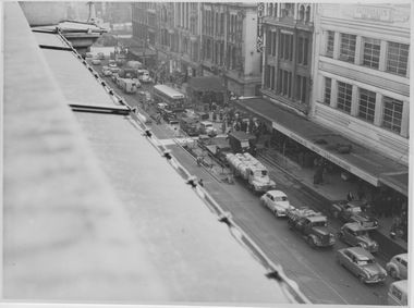
Photograph - City Traffic Congestion - set of 7, Various dates September 1954
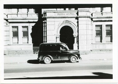
... City Traffic Congestion - set of 7...Six photographs showing traffic congestion that detains progress of trams in city streets. Road traffic congestion that detained tramcars in the city centre and on selected suburban roads had been a major concern to tramway operators dating back to the early 1900s. ...Incomplete series of photographs showing street traffic congestion in Flinders Street and Spencer Street Photograph City Traffic Congestion - set of 7 ...Six photographs showing traffic congestion that detains progress of trams in city streets. Road traffic congestion that detained tramcars in the city centre and on selected suburban roads had been a major concern to tramway operators dating back to the early 1900s. During the 1960s, and perhaps earlier, the Tramways Board regularly proposed ways of keeping motor traffic off the trams tracks, but little progress was achieved.Yields information about the perennial issue of motor traffic detaining trams. Incomplete series of photographs showing street traffic congestion in Flinders Street and Spencer Street5. Date 10/9/54, Time 1355 hrs, Flinders St, from Railway Buildings looking West over Degraves St. General traffic clear of tram tracks. 7. Date 17/9/54, Time 1355 hrs, Flinders St, from Railway Buildings looking West near Degraves St. 2 cars, 1 truck & 1 van parked & unattended. All moved within ten minutes. 8. Date 17/9/54, Time 1359 hrs, Flinders St, from Railway Buildings looking East towards Swanston St. Two utilities parked & unattended outside SEC. (Note policeman directing traffic.) See also Photo No 9. 9. Date 17/9/54, Time 1417 hrs, Flinders St, from Railway Buildings looking East towards Swanston St. Progressive view to No 8, two utilities in same position after 18 minutes. 12. Date 17/9/54, Time 1431 hrs, Flinders St, from Railway Building, Safety Zone at Swanston St. Progressive view to No 11 (missing from this album). Front truck about to leave after 10 minutes, rear truck remained parked. 11. Date 28/9/54, Time 0910 hrs, Spencer St, from roof of J S Gordon's near Flinders Lane, looking South. Three Northbound & 2 Southbound tramcars held up by truck caught in Southbound traffic when turning into lane. Image 7 - 28/9/54, 0902, Spencer St from J S Gordon's looking north. Has three trams in the distance, the Outwards parcels office, and a very congested/busy street with a Safety Zone in Spencer St just south of Collins St.congestion, flinders st, spencer st, motor traffic -
 Whitehorse Historical Society Inc.
Pamphlet, City of Nunawading Traffic Management, 1990
... City of Nunawading Traffic Management......Traffic...City...Pamphlet delivered to Rooks Road residents about the Council's traffic management plan. City of Nunawading Traffic Management Pamphlet Pamphlet ...Pamphlet delivered to Rooks Road residents about the Council's traffic management plan.Pamphlet delivered to Rooks Road residents about the Council's traffic management plan.Pamphlet delivered to Rooks Road residents about the Council's traffic management plan.rooks road nunawading, rooks road mitcham, traffic, city of nunawading -
 Melbourne Tram Museum
Document - Report, Melbourne & Metropolitan Tramways Board (MMTB), Peak traffic counts - city cordon, 1974 - 1976
... Peak traffic counts - city cordon...All Foolscap except .8, with notes, tables, charts and maps. .1 - "PM Peak traffic counts - March/April 1974 for the City Cordon and beyond the City Cordon" - May 1974 - red tape binding. .2 - "PM Peak Traffic counts - April 1975 - St Kilda Road Cordon" - June 1975 - red comb binding .3 - "AM Peak Traffic counts - October 1974 for the City Cordon and beyond the City Cordon" - December 1974 - red comb binding .4 - "St Kilda Road Cordon 1976 - PM Peak outbound traffic count" - Feb. 1976 - - red comb binding .5 - "St Kilda Road Cordon 1973 - AM Peak Inbound Oct. 1973" - dated Nov 1973 - red tape binding. .6 - "City Cordon Passengers counts AM Peak - Feb & March 1972, PM Peak March 1972 - showing effect of change of State public service and also introduction of late night shopping." - June 1972 - was bound with red tape. .7 - "PM Peak traffic counts - April 1975 for the city cordon and beyond the city cordon" - dated June 1975 - red comb binding .8 - "City Cordon 1977 PN Peak outbound traffic count" - dated June 1977, A4 - red comb binding...All Foolscap except .8, with notes, tables, charts and maps. .1 - "PM Peak traffic counts - March/April 1974 for the City Cordon and beyond the City Cordon" - May 1974 - red tape binding. .2 - "PM Peak Traffic counts - April 1975 - St Kilda Road Cordon" - June 1975 - red comb binding .3 - "AM Peak Traffic counts - October 1974 for the City Cordon and beyond the City Cordon" - December 1974 - red comb binding .4 - "St Kilda Road Cordon 1976 - PM Peak outbound traffic count" - Feb. 1976 - - red comb binding .5 - "St Kilda Road Cordon 1973 - AM Peak Inbound Oct. 1973" - dated Nov 1973 - red tape binding. .6 - "City Cordon Passengers counts AM Peak - Feb & March 1972, PM Peak March 1972 - showing effect of change of State public service and also introduction of late night shopping." - June 1972 - was bound with red tape. .7 - "PM Peak traffic counts - April 1975 for the city cordon and beyond the city cordon" - dated June 1975 - red comb binding .8 - "City Cordon 1977 PN Peak outbound traffic count" - dated June 1977, A4 - red comb binding Peak traffic counts - city cordon Document Report Melbourne & Metropolitan Tramways Board (MMTB) ...Set of eight report on traffic counts during the 1970's. All Foolscap except .8, with notes, tables, charts and maps. .1 - "PM Peak traffic counts - March/April 1974 for the City Cordon and beyond the City Cordon" - May 1974 - red tape binding. .2 - "PM Peak Traffic counts - April 1975 - St Kilda Road Cordon" - June 1975 - red comb binding .3 - "AM Peak Traffic counts - October 1974 for the City Cordon and beyond the City Cordon" - December 1974 - red comb binding .4 - "St Kilda Road Cordon 1976 - PM Peak outbound traffic count" - Feb. 1976 - - red comb binding .5 - "St Kilda Road Cordon 1973 - AM Peak Inbound Oct. 1973" - dated Nov 1973 - red tape binding. .6 - "City Cordon Passengers counts AM Peak - Feb & March 1972, PM Peak March 1972 - showing effect of change of State public service and also introduction of late night shopping." - June 1972 - was bound with red tape. .7 - "PM Peak traffic counts - April 1975 for the city cordon and beyond the city cordon" - dated June 1975 - red comb binding .8 - "City Cordon 1977 PN Peak outbound traffic count" - dated June 1977, A4 - red comb bindingIn top left hand corner "Lees" in pencil or ink and some with the report title on the left hand edge for filing purposes.trams, tramways, mmtb, tramways, surveys, passengers, st kilda rd -
 Federation University Historical Collection
Booklet, City of Ballarat Mayor's Report, 1957-1958, 1958
... ...city traffic...Barker Library (top floor) Mount Helen goldfields Ballarat was created a municipality on 17 December 1855, declared a Borough on October 1863, Proclaimed a City on 09 September 1970. city of ballarat mayor's report annual report jack chisholm city of ballarat coat of arms arms of ballarat john a. chisholm arthur nicholson alan pittard gordon scott arthur mason frederick oliver oscar curnow frank woodward william roff francis cutts nathaniel callow kenneth webb mrs john a. chisholm queen mother raaf school of radio city engineer's department public health report finance mr k. h. mitchell mr f. j. rogers building surveyor's department mr j. b. menhennet mr r. g. campbell city health inspector mr. r. g. biggs weights and measures inspector mr. w. mccormack libraries mr r. a. mccallum streets, parks and gardens water supply and sewerage ballaarat's voluntary community committees service clubs city traffic mr. j. h. sorrell sturt street gardens ballarat base hospital st john of god hospital queen elizabeth centre black hill black hill reclaimation Ballarat Benenevolent Asylum Green covered book City of Ballarat Mayor's Report, 1957-1958 Booklet Booklet John Fraser & Son Printers ...Ballarat was created a municipality on 17 December 1855, declared a Borough on October 1863, Proclaimed a City on 09 September 1970.Green covered bookcity of ballarat, mayor's report, annual report, jack chisholm, city of ballarat coat of arms, arms of ballarat, john a. chisholm, arthur nicholson, alan pittard, gordon scott, arthur mason, frederick oliver, oscar curnow, frank woodward, william roff, francis cutts, nathaniel callow, kenneth webb, mrs john a. chisholm, queen mother, raaf school of radio, city engineer's department, public health report, finance, mr k. h. mitchell, mr f. j. rogers, building surveyor's department, mr j. b. menhennet, mr r. g. campbell, city health inspector, mr. r. g. biggs, weights and measures inspector, mr. w. mccormack, libraries, mr r. a. mccallum, streets, parks and gardens, water supply and sewerage, ballaarat's voluntary community committees, service clubs, city traffic, mr. j. h. sorrell, sturt street gardens, ballarat base hospital, st john of god hospital, queen elizabeth centre, black hill, black hill reclaimation, ballarat benenevolent asylum -
 Ballarat Tramway Museum
Document - Photocopy, Neville Gower and Neville Hesketh, "Mayor's Report 1967-1968", Jul. 1997
... City Of Ballaarat... Trams... Railways... Civic History... Traffic...Page headed "City Traffic" added 19/12/2009 - and imaged along with following page which has the photo of the city tram at the terminus added. ...Looks at the introduction of traffic lights into the City and traffic problems and parking meters. ...Photocopy of part of City of Ballarat's Mayor's Report for 1967 - 1968. Originals held in the Ballarat Library. Three pages covering trams, railways, item on Country Roads Board (CRB) and traffic issues in Ballarat and small photos of trams at City terminus. Page headed "City Traffic" added 19/12/2009 - and imaged along with following page which has the photo of the city tram at the terminus added. Looks at the introduction of traffic lights into the City and traffic problems and parking meters.trams, tramways, city of ballaarat, trams, railways, civic history, traffic lights -
 Melbourne Tram Museum
Document - Memorandum and Table Cards, DJ Davidson, Henley Day - Saturday 3 November 1934, Nov. 1934
... Fireworks 8:15 to 9:15 Several memorandums and table card for tram scheduling for Henley Day, 3 November 1934 Hawthorn Inspectors' Roster Hanna St Inspectors' Positions City of Melbourne Traffic Arrangements...Fireworks 8:15 to 9:15 Several memorandums and table card for tram scheduling for Henley Day, 3 November 1934 Hawthorn Inspectors' Roster Hanna St Inspectors' Positions City of Melbourne Traffic Arrangements Henley Day - Saturday 3 November 1934 Document Memorandum and Table Cards DJ Davidson DJ Davidson, Mr Barton, Mr Coffey, Germann, Mr Eakins, Mr Bell, Mr Westcott, Signalman Scott, Mr Davis, WV McCall ...Handwritten note titled "Henley Night". Fireworks 8:15 to 9:15 Several memorandums and table card for tram scheduling for Henley Day, 3 November 1934 Hawthorn Inspectors' Roster Hanna St Inspectors' Positions City of Melbourne Traffic Arrangementstrams, tramways, instructions, events, special trams, table cards, henley regatta day -
Melbourne Tram Museum
Newspaper, The Sun, The Age, “A special tram – to the United States”, 24/01/1978 12:00:00 AM
... Benson is chairman of his city’s traffic committee and Class is head of company that will establish the tram service. ...Benson is chairman of his city’s traffic committee and Class is head of company that will establish the tram service. ...Newspaper clipping untitled: The Sun, Tuesday, Jan 24, 1978 Tram # 230 in photo, displaying route 48, "East Melbourne, Hoddle St" Trams # 401 and 484 sold to Seattle Seattle councillor, George Benson and Paul Class have convinced Seattle to buy two 50-year-old trams (401 and 484) to be used as tourist trams along heritage waterfront. Benson is chairman of his city’s traffic committee and Class is head of company that will establish the tram service. Trams cost $5000 each and cost another $40000 to deliver. Newspaper clipping titled: “A special tram – to the United States” The Age, Wednesday, February 1, 1978 Photo and text Two trams sold to City of Seattle as tourist attractions. Will run along 2.1 km line along waterfront beside Pugent Souna. First tram loaded onto a low-loader yesterday at Preston Tramways Workshops and driven through city to the dock where it will be lifeted aboard the Al lunga for trip across Pacific.trams, tramways, w class, sale of trams, tourist trams, seattle, transporting trams, tram 230, tram 401, tram 484 -
 Whitehorse Historical Society Inc.
Letter - Correspondence, Bill Sewart Athletic Track, 18/12/1995 12:00:00 AM
... Letter dated 18th December 1995 from Special Committee of Management of Bill Sewart Athletic Track to Chief Executive, City of Whitehorse concerning traffic management at East Burwood Reserve including diagrams....Whitehorse Historical Society Inc. 2-10 Deep Creek Road Mitcham melbourne sportsgrounds east burwood reserve bill sewart athletic track city of whitehorse traffic management at East Burwood Reserve Letter dated 18th December 1995 from Special Committee of Management of Bill Sewart Athletic Track to Chief Executive, City of Whitehorse concerning traffic management at East Burwood Reserve including diagrams. ...traffic management at East Burwood ReserveLetter dated 18th December 1995 from Special Committee of Management of Bill Sewart Athletic Track to Chief Executive, City of Whitehorse concerning traffic management at East Burwood Reserve including diagrams.traffic management at East Burwood Reservesportsgrounds, east burwood reserve, bill sewart athletic track, city of whitehorse -
 Melbourne Tram Museum
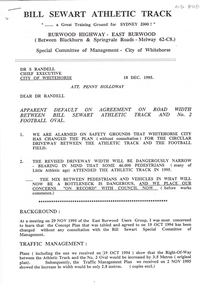
Drawing - "High Street tram terminus at Malvern Road", VicRoads, 2006
... Drawing - "High Street tram terminus at Malvern Road City of Stonnington Traffic Signal Model", drawing No. 6607-01. ...Melbourne Tram Museum 8 Wallen Road Hawthorn melbourne Drawing - "High Street tram terminus at Malvern Road City of Stonnington Traffic Signal Model", drawing No. 6607-01. ...Drawing - "High Street tram terminus at Malvern Road City of Stonnington Traffic Signal Model", drawing No. 6607-01. Shows the proposed layout of traffic markings, traffic signals etc for the new platform stop at High St and Malvern Road, Glen Iris. Prepared by vicroads 2006.Yields information about proposals for the Glen Iris terminus 2006A3 sheet printed in colourtramways, high st, malvern road, traffic control, platform stops, glen iris, route 6 -
 Box Hill Historical Society
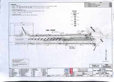
Photograph - Houses - Kangerong Road, City of Box Hill, 9/02/1979
... Photographs of buildings about to be demolished were taken by the City of Box Hill Traffic and By-Laws officers. Largely demolished weatherboard house at 14 Kangerong Road, Box Hill. ...Box Hill Historical Society Box Hill Heritage Centre Suite 7 Town Hall Hub Box Hill melbourne Photographs of buildings about to be demolished were taken by the City of Box Hill Traffic and By-Laws officers. Largely demolished weatherboard house at 14 Kangerong Road, Box Hill. ...Photographs of buildings about to be demolished were taken by the City of Box Hill Traffic and By-Laws officers. Largely demolished weatherboard house at 14 Kangerong Road, Box Hill. Also refer 1483 and 1485. B&w photoCaption of back of photo says 'front view'.kangerong road, box hill, demolitions, houses, weatherboard -
 City of Moorabbin Historical Society (Operating the Box Cottage Museum)
Photograph - Plateway (Wheelway) Steel, circa 1885
... There was a problem with the wheelway : there was only a single set of rails and this was established on the right-hand side of the Nepean Road, travelling towards the city. Traffic FROM the city travelled on the correct or left-hand side of the road. ...There was a problem with the wheelway : there was only a single set of rails and this was established on the right-hand side of the Nepean Road, travelling towards the city. Traffic FROM the city travelled on the correct or left-hand side of the road. ...By the later 1800s the dirt roads in the then out-lying areas of the City of Moorabbin became dangerous, and almost impassable due to huge potholes and muddy swampy areas. The heavily laden market gardener’s carts regularly broke axles and wheels, and horses foundered on their way to the Melbourne markets. Even worse, the heavier “iron maidens”, carrying their malodorous loads of sewage from Melbourne’s inner suburbs for dumping in the outlying areas of the City of Moorabbin, also got bogged in the mire. It was decided that a practical solution to this problem was to install a metal plateway on the side of the problematic roads. In about 1887 the Moorabbin Shire Centre Road, in the Brighton East area, two parallel metal rails were installed so that the wheels of carts could run along smoothly, the horse travelled in the filled, middle area between the rails. Point Nepean Road plateway was removed in 1930 and Centre Dandenong Road plateway was removed in 1934-35. The worn plateway along Centre Road, East Brighton (now known as Bentleigh), was gradually taken up in several pieces, commencing in the the1920s, when its condition deteriorated and it caused a hazard to bikes, pedestrians, motor-cycles and the few early cars. The early steel plateway, constructed by David Munro, and opened on 23rd March 1885 by Thomas Bent, was built along Nepean Highway, between Asling St. and Bay St. The Point Nepean Track was subsequently extended into Moorabbin with branches along Centre, Cumins, South, Wickham, and Keys Roads, the total length was 13 miles. In 1908-1909 plates were laid along Centre Dandenong Road to Ross Street Bentleigh This innovative solution proved successful and was used until gradually the main roads were upgraded, and motorised vehicles started to appear. Two parallel metal rails were installed in the right hand side of a few main roads in the Shire of Moorabbin so that the wheels of heavily-loaded market gardener's carts on their way to markets in Melbourne could run along smoothly. The horse pulling the carts travelled in the filled, middle area between the rails. The Steel Plateway was constructed by David Munro, and opened on 23rd March 1885 by Thomas Bent. The wheelway first only ran along Nepean Highway, but it soon extended from Centre Dandenong Road, along Nepean road to its junction with Chapel Street, St Kilda. Later branch lines were built along Centre Road, Bentleigh as far as Warrigal Road and, according to early photographs, along Wickham Road Moorabbin as well. This innovative solution proved successful and was used until gradually the main roads were upgraded, and motorised vehicles started to appear. There was a problem with the wheelway : there was only a single set of rails and this was established on the right-hand side of the Nepean Road, travelling towards the city. Traffic FROM the city travelled on the correct or left-hand side of the road. The exception to this rule was the malodorous iron-clads, heavily riveted iron carts, generally travelling in convoy, carrying several tons of human effluent out of Melbourne to be trenched-in in the sandy soil of the Moorabbin district. Moorabbin City Council donated and installed a small section of Plateway at Box Cottage Museum in 1984melbourne, brighton, moorabbin, roads, plateway, wheelway, transport, st kilda, bent thomas, munro david, market gardens, steelway, carts horse-drawn, iron maidens, point nepean track -
 City of Melbourne Libraries
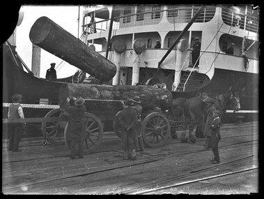
Photograph (item), Bull, Hugh Jones, 1897-1993, Unloading timber at Victoria Dock, 1933
... By 1947, however, only 1.5% of city traffic was horse-drawn. In 1952 the large horse cartage company A. ...By 1947, however, only 1.5% of city traffic was horse-drawn. In 1952 the large horse cartage company A. ...Photographer notations on slide: "Unloading Timber at Wharves 1933 Age B5" Published: Age (Melbourne, Vic.: 1854- ), Tuesday 15 August 1933 MAHOGANY FROM MANILA. (1933, August 15). The Age (Melbourne, Vic. : 1854 - 1954), p. 11. Retrieved January 16, 2026, from http://nla.gov.au/nla.news-article204377024 Published title: MAHOGANY FROM MANILA Published Caption: Age Tue 15 Aug 1933 Caption: Unloading Mahogany Logs brought from Manila, Philippine Islands, by the steamer Taiping, which berthed yesterday at Victoria Dock. The vessel discharged twenty logs, each weighing three tons, the first shipment of this type of timber landed in Melbourne. Research by Project Volunteer, Louise McKenzie: This photograph in many ways epitomises Melbourne in the 1930s. It is a time of enormous growth, development and change. But before delving into that, the photo itself is very powerful. The huge mahogany logs being unloaded appear to be so heavy that the ship itself seems to list to port as they are craned over the side. They are being levered into a cart to which two large and sturdy Clydesdale horses are hitched. In contrast to the traditional horses, the wharf is crisscrossed with modern railway tracks. Unloading is both mechanical and manual, and the scene is one of intense interest to a young boy bystander. The ship appears to be squat and solid, but the whole image also gives a feeling of movement and intensity. The mahogany being delivered to Melbourne would be intended for high quality furniture. In the 1930s Australia actually had a growing timber industry, but much of the eucalyptus wood was being utilised for mass produced furniture, and much of this furniture would then have had a veneer applied to it. The fact that it was economic to import this timber from the “Philippine Islands” – not a traditional trading market for Australia – reflects a Victorian economy that was strong enough to support a growing demand for good quality furniture Mahogany was described as a classic, strong hardwood, often used for dark opulent furniture. In the 1930s the importation of timber from Manila (Philippines) to Australia was a notable trade, particularly in Philippine Lauan (often referred to as Philippine Mahogany), which was used as a cheaper alternative to other hardwoods. 1930s furniture, dominated by the art deco style, used a mix of luxurious exotic woods like mahogany, macassar and ebony for high-end pieces, often veneered over less expensive woods such as walnut, birch and poplar, and with plywood, chrome and lacquer also popular for more practical, streamlined designs during the Depression era. By the mid 1930s timber mills were being relocated away from the immediate dock area, but the fact that these logs were being transported by horse-drawn cart implies that the load would not have had to be taken too far for milling. 1885 the Melbourne Harbour Trust Commissioners had decided that land in or near the city was far too valuable to be used as timber yards. Furthermore, large stacks of timber posed a fire risk. The Trust asked the Victorian Government to reserve a site on the east side of the Yarra River opposite Yarraville and Spotswood. Here, in 1889, the Trust began building six jetties and a wharf specifically for the landing of timber. Clydesdale horses were initially brought to Victoria from Tasmania in the 1830s, and with the 1850s gold rush they were imported direct from Scotland. Melbourne was from its earliest years an important centre of horse-breeding from both imported and colonial-bred stock, providing the well-built draught horse for pulling heavily loaded wagons, the harness horse for delivery work and drawing coaches, and the saddle-horse used for riding. Stud breeding facilities were advertised from the early 1840s. By the 1870s the horse export trade was thriving, and the Port of Melbourne was the country's busiest exporter of horses to Indian, Asian and New Zealand markets. Kirk's Melbourne Horse and Carriage Bazaar in Bourke Street first advertised for business in 1840, and by the 1850s Bourke Street West was famed for its horse bazaars and saleyards. The Victorian Clydesdale Horse Society reports that Clydesdale working horses were a vital part of Melbourne's infrastructure and agricultural industry in the 1930s, when they reached the peak of their popularity despite the increasing competition from mechanization. Their main roles and usage at this time were: • City Delivery: Clydesdales were a common sight for metropolitan deliveries, particularly for breweries (such as Carlton & United Breweries), milk runs, and bread deliveries. • Industrial Work: They were heavily used for hauling cargo at the docks, in construction, and at specialized sites like the Truganina Explosives Reserve, where they pulled wagons. • Agriculture: In surrounding rural areas, they were the primary power source for ploughing and agricultural machinery. • Specialization: By the 1930s, the Clydesdale was smaller and more compact than the Shire or Percheron breeds, making them ideal for navigation in urban environments. After the 1930s their numbers decreased due to the onset of WWI and mechanisation. Wartime petrol rationing led to a brief revival for the working horse, as suburban tradesmen, now used to motor delivery, took their old jinkers out of mothballs. By 1947, however, only 1.5% of city traffic was horse-drawn. In 1952 the large horse cartage company A. Kellet Pty Ltd sold its 250 horses and converted its Richmond stables to storage. In the 1950s at Station and Princes piers, wharf labourers refused to work with the six draught horses still being used to haul trolleys and which were soon superseded by the fork lift, semi-trailer and mobile crane. Where carefully trained horses had once shunted trains in city goods yards, a few hundred a week were now being killed at the abattoirs for pet and human consumption. The last MCC dray horse was withdrawn from service in 1958, but some of the few remaining working animals are used by the mounted police for crowd control at demonstrations and football games. The death knell had also sounded for the associated trades of farrier, saddler and blacksmith. Our photo, therefore, showing the wharf with both the haulage Clydesdales and the rail lines, is a strong visual summary of the social and economic changes experienced in Victoria in the 1930s and on towards the 1950s. Our photo is located at Victoria Dock (also known as Victoria Harbour) which is still an active component of Melbourne’s port system. In 1892 the West Melbourne Dock (later Victoria Dock) was opened, downstream and immediately west of the Spencer Street railway shunting yards. It contained a swing basin for ships, replacing the one which had been provided on the south side of the river, later to be the Duke and Orr dry dock, west of the Charles Grimes Bridge. Further west was the South Wharf along the river bank. The history of Victoria Dock is extremely well described by Ashley Smith in his 2 March 2022 article in Docklands News, and its accompanying aerial photo of the Dock taken in 1934. He writes: "In the early 1930s Victoria Dock was one of the biggest sites for trade and export in Melbourne. A constant queue of ships sailed in, unloaded their cargo, recharged and reloaded, then left for the next port. Around the time this photo was taken (found in a 1934 photo book), the trapezium-shaped basin had been through some changes since its construction in the 1890s. The 497-metre-long Central Pier, finished in 1919, now featured six sheds to house the ever-increasing volume of cargo. The entrance had also been widened in the 1920s to allow better access. Some of the berths featured three-ton jib electric cranes to help with loading cargo and a rail network connected to the State Railway service. By the time construction was completed, the dock was 39 hectares and hailed as the second-largest dock in the world (behind Cavendish Dock, Barrow-in-Furness). To further save costs, excavations were dug to a more reasonable seven metres below low water, instead of British engineer Sir John Coode’s recommended 8.3 metres. Even then, the costs were still around £900,000. It was envisaged, with the extra wharfage, that around thirty 90-metre ships could berth inside. On March 22, 1892, Victoria Dock was opened by Victoria’s Governor, the Earl of Hopetoun (later Australia’s first Governor-General) who opened the sluice to let the Yarra in. It took six days to fill the basin with The Leader newspaper estimating that it would take another six months to completely fill (March 26, 1892). In the end, it took nearly a year before the first ship was allowed to enter on February 20, 1893, when the steamer Hubbuck sailed in to unload 1200 tonnes of cargo in 15 hours. The Argus (February 23, 1893) reported that the ship’s captain, J. R. Brodie, called the Yarra “better than the Thames”, and compared Victoria Dock favourably to the Albert Dock (Liverpool)." This would be a good time to move our focus on to the Taiping, which is the transporter of these giant mahogany logs. The Taiping was a steel-hulled, single-screw passenger-cargo Chinese steamer, which today has the dubious legacy of being involved in a collision headlined as “The Chinese Titanic”. It was constructed by the Hong Kong and Shampoa Dock Company at its facility in Hong Kong, with completion in 1926 for service under the Australia Oriental Line. Her gross register tonnage measured 4,324 tons, reflecting her design for inter-island and coastal trade routes, accommodating both passengers and freight. She operated routes connecting Australian ports with East Asian destinations. As World War II approached, Taiping continued predominantly working the trade routes between China and Australia, until December 1941, when she evacuated women and children from Hong Kong to Manila just before Japanese forces overran the region. She then safely reached Australia despite enemy air raids. Taiping was then requisitioned by the Royal Navy and repurposed as a victualling stores issuing ship for the Eastern Fleet, supporting logistical needs in the Pacific and Indian oceans. Returned to the Australian Oriental Line in 1947, she underwent refitting and by mid-1948 was chartered to the Shanghai Shipping Company, and modified for greater passenger accommodation – approximately 500 passengers. In 1948/49 the Chinese Civil War took place. The Taiping departed Shanghai on 26 January 1949 as one of the final vessels evacuating civilians from to Keelung Harbour in Taiwan. Reports indicate that the Taiping carried double the rated capacity of passengers i.e. 1000. The ship carried families, military personnel, civilians, carrying personal belongings, gold and valuables in hope of resettlement in Nationalist Taiwan. It also held heavy cargo in the form of silver and gold bullion loaded by the Central Bank of China. Because of the risk of patrols, and to conserve fuel, the Captain took the ship away from the usual open-sea passage, and instead navigated along the coast. He also extinguished navigation lights to avoid detection. Shortly after midnight on 27 January 1949 the Taiping collided with the smaller cargo steamer Chien Yuan in the East China Sea near the Zhoushan Archipelago. The Chien Yuan was also operating in darkness. The subsequent collision was catastrophic. The Chien Yuan sank with in 5 minutes, with the loss of 72 of its 74 crew. The Taiping sustained severe structural compromise from the broadside strike and initially remained afloat, then made a swift descent into the freezing water, with no attempt at an organised evacuation. No formal recovery process was instigated, however a distress signal went out. 32 survivors were picked up by the Australian destroyer HMAS Warramunga (on patrol nearby), a passing US vessel found 2 more, and local Zhoushan fishermen retrieved others. In the end, only 37 people survived. The event is remembered as a poignant moment in the mass migration to Taiwan, with families tragically separated. A memorial to the disaster exists at the Keelung Harbour naval base on Taiwan. With its total of over 1,500 deaths, it constituted one of the worst peacetime maritime losses. It is sometimes referred to as the “Oriental Titanic” because of the similarly large loss of life and speed of demise with the RMS Titanic in 1912. A fictional depiction of this event appears in the John Woo movies “The Crossing (Part 1) (2014), and The Crossing II (2015), known in Chinese as “Taiping Wheel”. The narrative weaves a story around pre-disaster romances and wartime turmoil among passengers, culminating in the ship’s rapid sinking. “The production, a high-budget Sino-Taiwanese-Hong Kong co-effort, portrays the event as a microcosm of the 1940s Sino-Japanese and civil war legacies, though critics noted the melodramatic style prioritizing spectacle over historical precision.” In conclusion, it is nice to return to our photo, and observe the people involved in this moment. The dockworkers are, so typical of the 1930s, dressed in what looks to us like formal clothing – dark suits or coats, white shirts, and black hats. I am particularly drawn to the young boy, bare-headed, arms crossed, and so intent on the unloading process. He too is wearing a white shirt, black trousers and jacket, and black shoes. This is 1933 Melbourne – but the haircut he is sporting is now very “hipster” and modern in 2026 Melbourne. References: MAHOGANY FROM MANILA. (1933, August 15). The Age (Melbourne, Vic. : 1854 - 1954), p. 11. Retrieved January 30, 2026, from http://nla.gov.au/nla.news-article204377024 Wikipedia, Taiping steamer, https://en.wikipedia.org/wiki/Taiping_(steamer) Wikipedia, Victoria Dock, https://en.wikipedia.org/wiki/Victoria_Dock_(Melbourne) Docklands News, Ashley Smith, 2 Mar 2022, https://www.docklandsnews.com.au/victoria-dock/ Living Histories: Heritage Council of Victoria, Jill Barnard, 2008, Jetties and Piers, https://livinghistories.net.au/wp-content/uploads/2015/11/Jetties-ONL-intro_Part-1.pdf eMelbourne, Wharves and Docks, https://www.emelbourne.net.au/biogs/EM01612b.htm Australian Academy of Technological Sciences – Harvesting Wood, https://www.austehc.unimelb.edu.au/tia/225.html Old Treasury Building, On the Water – The Docks, https://tinyurl.com/3wkbk66m Old Treasury Building, On The Road, https://tinyurl.com/dw44yr3t Port of Melbourne, Victorian Places, https://www.victorianplaces.com.au/port-of-melbourne Docklands Heritage Study - Environmental History, https://mvga-prod-files.s3.ap-southeast-4.amazonaws.com/public/2024-05/docklands-heritage-review-thematic-environmental-history-1991.pdf eMelbourne, Horses, https://www.emelbourne.net.au/biogs/EM00723b.htm Victorian Clydesdale Horse Society, https://www.clydesdalesvic.org.au/history The Crossing, https://letterboxd.com/film/the-crossing-i/Photographer notations on slide: "Unloading Timber at Wharves 1933 Age B5"ships, shipping, timber industry, shipwrecks, horses, docks, wharves, 1930-1939, wars, docklands -
 Warrnambool and District Historical Society Inc.
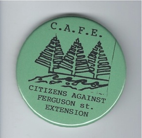
Badge, Citizens against Ferguson St Extension
... traffic in the quiet suburban areas. The scheme did not go ahead. This badge is of minor interest as an example of a local campaign against an unpopular City Council proposal. ...This badge was issued to supporters of the 1980s campaign called ‘Citizens Against Ferguson Street Extension’. Ferguson Street is in East Warrnambool and at the time the road was formed but there were no houses on the north side. The proposal was to extend the street at the north east end so that access could be made to east Warrnambool and Deakin University. The local residents opposed the proposal because it would increase traffic in the quiet suburban areas. The scheme did not go ahead. This badge is of minor interest as an example of a local campaign against an unpopular City Council proposal. This is a green circular-shaped badge made of plastic. It has black printing with a sketch of three Norfolk Island pine trees on the front and a metal clip at the back for attachment to a person’s clothing. The back has an image of a map of Australia.‘C.A.F.E. Citizens Against Ferguson St. Extension’ ferguson street, history of warrnambool -
 Port of Echuca
Functional object - Brake Van (Guards Van), 1914
... traffic on 23rd March 1914. Altered to ZL448 incorporating long travel draft gear, 28th November 1961. Off Register on 10th August 1982 & sold to Echuca City Council 3rd September 1982 ...traffic on 23rd March 1914. Altered to ZL448 incorporating long travel draft gear, 28th November 1961. Off Register on 10th August 1982 & sold to Echuca City Council 3rd September 1982 This is an example of the most numerous type of brake van used by Victorian Railways over a very long period. ...Standard Victorian Railways Brake Van (Guards Van) originally Z 448 built at Newport Workshops & body built by Grimmond & Party butty gang. Entered traffic on 23rd March 1914. Altered to ZL448 incorporating long travel draft gear, 28th November 1961. Off Register on 10th August 1982 & sold to Echuca City Council 3rd September 1982 This is an example of the most numerous type of brake van used by Victorian Railways over a very long period. Brake vans would not have been a common sight at the Wharf as the line to the Wharf was operated as a siding from Echuca Station, so a brake van was not required. It is possible that a shunter walked ahead of the train to and from the wharf. This vehicle is significant. However a large number survive in operable condition around Victoria. Standard Vic Rail Brake (Guards) Van. wharf, shire of campaspe, newport workshop, brake van, grimmond & party butty gang, guards van, rollingstock collection, steam trains -
 Victoria Police Museum
Photograph (police car), 1954
... Victoria Police Museum 313 Spencer Street Docklands melbourne police vehicles; transport branch; wireless patrol; motor police branch; motor traffic section; dodge divisional van Dodge Divisional Van outside the City Watch House Russell St, circa 1954 Photograph (police car) ...Dodge Divisional Van outside the City Watch House Russell St, circa 1954police vehicles; transport branch; wireless patrol; motor police branch; motor traffic section; dodge divisional van -
 Victoria Police Museum
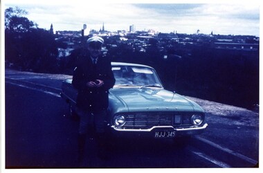
Photograph (police car)
... Victoria Police Museum 313 Spencer Street Docklands melbourne First Constable Joh Gurr 12361 of the Mobile Traffic Section with a Falcon Q car. police vehicles; wireless patrol; motor transport branch; motor transport section; ford falcon car Ford Falcon, registration number HJJ-345, with officer standing beside it and the city sky line in the background. ...First Constable Joh Gurr 12361 of the Mobile Traffic Section with a Falcon Q car.Ford Falcon, registration number HJJ-345, with officer standing beside it and the city sky line in the background. Circa 1961police vehicles; wireless patrol; motor transport branch; motor transport section; ford falcon car -
 Ballarat Clarendon College
Postcard
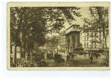
... It is a very busy city and the taxis and cars make a dreadful noice - far greater noise than in London. Though traffic is just as great - We are having lovely weather to see this beautiful city. ...It is a very busy city and the taxis and cars make a dreadful noice - far greater noise than in London. Though traffic is just as great - We are having lovely weather to see this beautiful city. ...Postcard sent to Ballarat College boarder, William L Sloss, by his mother Bernice A Sloss during a visit to Paris with his father in 1929.Its slightly formal phrasing gives insight into parent-child relations of the era. Black and white illustrated postcard; photograph of Paris scene on front; hand-written letter on back and 90p stamp attached;Address: Master Bill Sloss / Ballarat College / Ballarat - Victoria / Australia Letter: 21/3/29 / This is just a tiny corner of Paris. It is a very busy city and the taxis and cars make a dreadful noice - far greater noise than in London. Though traffic is just as great - We are having lovely weather to see this beautiful city. We are all well. Hope you are. Daddy is visiting hospital. Love from us all - Your loving mother, Bernice A Sloss.bernice-a-sloss, ballarat college, boarding, 1929, bill-sloss, william-l-sloss-1934, postcard -
 Glen Eira Historical Society
Document - NEERIM ROAD RAILWAY CROSSING AND GATES GLEN HUNTLY
... City Council... Elsternwick... Glen Huntly... Caulfield Park... Caulfield Racecourse... Normanby Road... Dandenong Road... Railway Buildings... Railway Stations... Land Transport... Transport Establishments... Hordern A.G.... Dunstan Don... Hordern Bill... Needham J.G.... Advertisements... Graphics... Advertising... Advertising Signs... Signs... Estate Agents... Business People... Stockdale and Leggo... Buildings Structures and Establishments... Occupations... United Signs... Signs... Communication Devices... Motor Vehicles... Glenhuntly Railway Station... Town Planning... Civic and Landscape Art... Engineers... Professionals... Traffic...City Council Elsternwick Glen Huntly Caulfield Park Caulfield Racecourse Normanby Road Dandenong Road Railway Buildings Railway Stations Land Transport Transport Establishments Hordern A.G. Dunstan Don Hordern Bill Needham J.G. Advertisements Graphics Advertising Advertising Signs Signs Estate Agents Business People Stockdale and Leggo Buildings Structures and Establishments Occupations United Signs Signs Communication Devices Motor Vehicles Glenhuntly Railway Station Town Planning Civic and Landscape Art Engineers Professionals Traffic Road Transport Transport Maps Documents Plans Document NEERIM ROAD RAILWAY CROSSING AND GATES GLEN HUNTLY ...This file contains two items: 1/Twelve photographs of the Glen Huntly, Neerim Road hand-operated railway gates, dated 1983 and November 1985, photographer unknown, and two black and white copies of two of the original photographs. Four photographs are in black and white and eight are in colour, all picturing the Gatekeeper’s shelter and/or the railway gates. Six photographs dated 1985 include the Gatekeeper, unidentified, in some photos operating the gates. 2/A three-page pamphlet dated 03/05/1979 promoting a public meeting at the Caulfield Town Hall to debate Road Grade Separation proposals for the Neerim Road and Glenhuntly Road railway crossings. Document details the proposed VicRail improvement and four alternative improvements as we as a blank questionnaire for the submission of ideas regarding the proposals to the Caulfield City Council Urban Planner. A short summary of other concerns held by two councillors and an engineer regarding the proposal is also included, as is a Railway Noise Level. Railway Pamphlet also includes a map of the area surrounding the railway crossings under discussion 1977.glenhuntly road, neerim road, caulfield, railway gates, gates, hand-operated railway gates, railways, roads and streets, railway crossings, architectural features, town halls, official buildings, vicrail, meetings, public meetings, caulfield town hall, gatekeepers, caulfield city council, elsternwick, glen huntly, caulfield park, caulfield racecourse, normanby road, dandenong road, railway buildings, railway stations, land transport, transport establishments, hordern a.g., dunstan don, hordern bill, needham j.g., advertisements, graphics, advertising, advertising signs, signs, estate agents, business people, stockdale and leggo, buildings structures and establishments, occupations, united signs, signs, communication devices, motor vehicles, glenhuntly railway station, town planning, civic and landscape art, engineers, professionals, traffic, road transport, transport, maps, documents, plans -
Glen Eira Historical Society
Document - Glen Eira Residents Association
... Interior features president Don Dunstan reflecting on issues relevant to GERA occurring over the preceding twelve months, with an emphasis on the dubious behaviour of the City Council, as well as two colour photographs: one of Dunstan himself and one of traffic at Elsternwick Junction. ...Interior features president Don Dunstan reflecting on issues relevant to GERA occurring over the preceding twelve months, with an emphasis on the dubious behaviour of the City Council, as well as two colour photographs: one of Dunstan himself and one of traffic at Elsternwick Junction. ...Six items pertaining to Glen Eira Residents Asssociation Inc. 1/Two copies of the minutes of a Committee Meeting of Glen Eira Residents Association Inc., held on 04/12/2001. The minutes cover a range of routine meeting items, as well as the postponed release of the Princes Park Master Plans and the proposed construction of car parks at Caulfield Racecourse. 2/A copy of Glen Eira Residents’ Association Inc.’s 30/05/2003 newsletter, notifying members of matters presently before Glen Eira City Council for purposes of evaluation. Matters include an admonishment to the Council to sort out anomalies between the C25 Amendment (80/20 Plan) and the Melbourne 2030 Plan, the success at convincing the Ministerial panel to adopt GERA’s views regarding the C14 Council Plan for the Caulfield Racecourse, a request for information from the Council regarding the previous year’s rate increase, a request for information from the Council regarding spending on planning for improvements to Princes Park, a call for the Council to improve its consultative procedures, a recommendation that the purpose of Glen Eira News be expanded to the making of suggestions for city improvement, and a notification of the measures implemented to improve the visibility of Caulfield Racecourse’s usability by the public. Includes a black-and-white photograph of Orrong Road, Elsternwick, illustrating what Glen Eira’s roads would look like if lined with trees, which was excluded from Glen Eira News on account of a current prohibition on the making of suggestions for city improvements. 3/Four copies of a booklet entitled ‘A Short Guide to Planning Procedures’, composed 08/2006, which endeavours to explain, as concisely as possible, the methodology by which Glen Eira City Council approves real estate developments and issues planning permits. 4/A booklet containing the minutes of the 05/10/2009 Annual General Meeting of Glen Eira Residents’ Association Inc. Details both routine items and more specific matters of discussion, such as inappropriate charges on the part of the Glen Eira City Council and the proposed inception of a questionnaire to evaluate local residents’ opinion of the Council. 5/A booklet announcing the 07/10/2010 Annual General Meeting of Glen Eira Residents’ Association Inc. at St. John’s Uniting Church, Elsternwick. Front cover details agenda and contains four colour photographs pertaining to public transport (buses, trams, trains) within the city. Interior features president Don Dunstan reflecting on issues relevant to GERA occurring over the preceding twelve months, with an emphasis on the dubious behaviour of the City Council, as well as two colour photographs: one of Dunstan himself and one of traffic at Elsternwick Junction. The rear cover contains the Financial Statement presented to the Meeting. 6Two copies of a printout of an article from the website of Glen Eira Residents’ Association Inc., accessed 19/06/2012, explaining the affects wrought as a result of the implementation of Planning Scheme Amendment C87. Said amendment changes the Planning Scheme protecting neighbourhood character by replacing the previous Significant Character Area (SCA) designation with the new designations of Neighbourhood Character Overlay (NCO) and Design and Development Overlay (DDO). In developing the Amendment, Glen Eira City Council commissioned Planisphere to procure the Planisphere Final Report, in which recommendations regarding the expansion, creation and deletion of SCAs were offered. The article contains a summary of said recommendations.glen eira residents’ association inc., clubs and associations, glen eira, meetings, minutes, campbell jack, dunstan don, marwick geoff, pleydell max, teseriero dominic, robins kevin, princes park, south caulfield, glen eira city council, local government, councillors, brennan martin, victorian local government association (vlga), erlich mayor, project manikato, caulfield racecourse, caulfield racecourse flat, racecourses, parks, car parks, kennedy cr., kennedy norman mr., crown land, glen eira road, rippon lea, c25 plan (80/20), melbourne 2030 plan, c14 council plan, rates, orrong road, elsternwick, trees, station street, caulfield north, neerim road, glenhuntly, glenhuntly park, orrong ward, grossbard cr., martens cr., building permits, delegated planning committee (dpc), steward joy, brohier peter, campbell fliss, scutt alex, ray darren, hannah brian, st. john’s uniting church, mees paul dr., elsternwick club, sandham street, melbourne weekly bayside, glen eira debates, walsh investigation, whelen investigation, forge cheryl cr., whiteside helen mayor, save our suburbs (sos), walsh mary, walsh kevin, french christine, elsternwick junction, planning scheme, planning scheme amendment c87, significant character areas (scas), planisphere final report, oakdene crescent, carnegie, blackwood street, housing diversity areas, urandaline grove, caulfield, normanby road/park crescent, kambrook road, balaclava road, hawthorn road tramway estate, caulfield south, ulupna road, ormond, murray street, prentice street, kambea grove, chestnut street, mcpherson avenue, queens avenue, caulfield east, derby crescent, clarinda street, st. james parade/downshire road, exhibition street, mckinnon, field street, boyd park, murrumbeena, lindsay avenue, lydson street -
Glen Eira Historical Society
Newspaper - Kornhauser Family
... The Glen Eira City Council denied their application owing to complaints from neighbours pertaining to noise and traffic congestion associated with the facility. ...The Glen Eira City Council denied their application owing to complaints from neighbours pertaining to noise and traffic congestion associated with the facility. ...This file contains two items: 1/A printout of an article from the website of the Sydney Morning Herald, dated 18/09/2013 (albeit accessed on 28/01/2014), pertaining to the legal efforts on the part of Nicole and Eliezer Kornhauser to secure the rights to operate an (unnamed) Orthodox Jewish school out of their home at 8 Springfield Avenue, St. Kilda East. The Glen Eira City Council denied their application owing to complaints from neighbours pertaining to noise and traffic congestion associated with the facility. The decision was subsequently upheld by the Victorian Civil and Administrative Tribunal. Thus, the Kornhausers have now taken their case to the Supreme Court. 2/A clipping of a newspaper article from The Age, dated 12/01/2014, pertaining to a conflict between Nicole and Eliezer Kornhauser and their neighbours. Said parties were already at odds with another, owing to the neighbours requesting that the Glen Eira City Council deny the Kornhausers permission to extend their facility owing to the aforementioned issues of noise and traffic congestion. But matters came to a head when the couple issued unsolicited death threats to local resident Jannine Gross and her husband – especially in the light of the Council electing to permit the extension after all. There is a discrepancy between the first and second items. The first item implies that the Kornhausers seek permission merely to operate their facility, whereas the second item implies that they seek permission to extend it.kornhauser family, kornhauser eliezer, kornhauser eric, kornhauser nicole, schools, religious structures and establishments, jewish community, legal events and activities, court procedures, vedelago chris, victorian civil and administrative tribunal (vcat), martin philip, springfield avenue, st. kilda east, mansions, merkos women program, resident action, gross jannine, pilling neil -
Glen Eira Historical Society
Document - SHELFORD GIRLS’ SCHOOL AND KINDERGARTEN
... City of Caulfield... Shelford C.E.G.G.S.... Caulfield... Glen Eira Road... St Mary’s Anglican Church... Seymour Road... Allison Road... ‘Helenslea’... Hood Justice Mr... Hood Crescent... St Mary’s Parish Hall... Helenslea Road... education... gymnasiums... schools... students... secondary schools... primary schools... Bentleigh... classrooms... car parks... libraries... traffic...City of Caulfield Shelford C.E.G.G.S. Caulfield Glen Eira Road St Mary’s Anglican Church Seymour Road Allison Road ‘Helenslea’ Hood Justice Mr Hood Crescent St Mary’s Parish Hall Helenslea Road education gymnasiums schools students secondary schools primary schools Bentleigh classrooms car parks libraries traffic playgrounds teachers windows plans Shelford Planning Brief Kilvington Planning Brief Shelford Church of England Girls’ Grammar School Floyd J fences Kilvington Baptist Girls’ Document SHELFORD GIRLS’ SCHOOL AND KINDERGARTEN ...This file contains 2 items relating to plans for the buildings and grounds of the school: 1/2 copies (1photocopy, 1 original) of the July 1982 ‘Shelford Planning Brief: Church of England Girls’ Grammar School’, written by the Caulfield City Council. The brief describes the history of the school, its current grounds and plans for future expansion. It also contains 2 ground plans: one of the existing school site and 1 of the planned future school site. 2/1 copy of a City of Caulfield Council memo regarding the July 1982 Shelford Planning Brief, describing small changes to the brief. Written by J. Floyd, 24/11/1982.city of caulfield, shelford c.e.g.g.s., caulfield, glen eira road, st mary’s anglican church, seymour road, allison road, ‘helenslea’, hood justice mr, hood crescent, st mary’s parish hall, helenslea road, education, gymnasiums, schools, students, secondary schools, primary schools, bentleigh, classrooms, car parks, libraries, traffic, playgrounds, teachers, windows, plans, shelford planning brief, kilvington planning brief, shelford church of england girls’ grammar school, floyd j, fences, kilvington baptist girls’ -
Glen Eira Historical Society
Plan - Mount Scopus College, St. Kilda East
... City of Caulfield... Mayfield Street... Talbot Avenue... Floyd Jeff... Building Permits... Planning Act... Shaw House... M.M.B.W. Planning Scheme... Classrooms... Kindergarten... Playgrounds... Library... Multipurpose Hall... Car Parking... Students... Teachers... Staff... Secondary School... Primary School... Synagogue... Architects... Syman Justin and Bialek... Site Plan... Hall... Building Development... Education Department... Town and Country Planning Board... Brick... Zoning... Traffic...City of Caulfield Mayfield Street Talbot Avenue Floyd Jeff Building Permits Planning Act Shaw House M.M.B.W. Planning Scheme Classrooms Kindergarten Playgrounds Library Multipurpose Hall Car Parking Students Teachers Staff Secondary School Primary School Synagogue Architects Syman Justin and Bialek Site Plan Hall Building Development Education Department Town and Country Planning Board Brick Zoning Traffic Property Landscape Planning Planting Fence Plan Mount Scopus College, St. ...A copy of the amended Planning brief for the development of Mount Scopus College dated 24/10/1982. It includes a covering letter listing the amendments. The planning brief describes the school’s facilities, classrooms, playground and the planned development of the school. It includes a site plan and an architect’s illustration of the proposed development.mount scopus college, st. kilda east, city of caulfield, mayfield street, talbot avenue, floyd jeff, building permits, planning act, shaw house, m.m.b.w. planning scheme, classrooms, kindergarten, playgrounds, library, multipurpose hall, car parking, students, teachers, staff, secondary school, primary school, synagogue, architects, syman justin and bialek, site plan, hall, building development, education department, town and country planning board, brick, zoning, traffic, property, landscape planning, planting, fence -
 Bendigo Historical Society Inc.
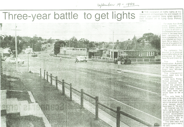
Newspaper - LONG GULLY HISTORY GROUP COLLECTION: THREE-YEAR BATTLE TO GET LIGHTS
... History House 11 Mackenzie Street Bendigo goldfields BENDIGO History long gully history group The Long Gully History Group - Three-year battle to get lights Long Gully Primary School The Road Construction Authority Mr Ted Coleman Bendigo City Council Rite-Way Copy of a newspaper article titled Three-year battle to get lights. Paper dated September 19, 1984. Article mentions there will be an installation of traffic lights at the intersection of Eaglehawk Rd and Creeth St. after a three year campaign. ...Copy of a newspaper article titled Three-year battle to get lights. Paper dated September 19, 1984. Article mentions there will be an installation of traffic lights at the intersection of Eaglehawk Rd and Creeth St. after a three year campaign. The intersection would cater fully for pedestrians and make it a lot safer for the school children.bendigo, history, long gully history group, the long gully history group - three-year battle to get lights, long gully primary school, the road construction authority, mr ted coleman, bendigo city council, rite-way -
 Bendigo Historical Society Inc.
Newspaper - LONG GULLY HISTORY GROUP COLLECTION: BENDIGO'S CENTURY VOLUME SEVEN: 1960 - 1969
... Traffic Commission... Lansell FAmily... ABEV-1... Bendigo Ordnance Factory... ACTU... Bendigo Trades Hall Council... The Ramsay Report... Bendigo Benevolent Home... Bendigo Home and Hospital for the Aged... Princess Theatre... Amoco... Lake Eppalock... Bendigo Training Prison... Bendigo Police Station Lock-up... Shamrock Hotel... Rifle Brigade Hotel... Hopetoun Hotel... ANZ Bank... Marong Shire Offices... Sir Rohan Delacombe... St Paul's Church... Que O'Hoy... Waldron Family... Windermere Hotel... Aids & Appliance Shop... Anne Caudle Centre... E C Thompson... Mayfair Hams... Sandhurst Guest House... Lyric Theatre... Chinese Joss House... Ordnance Factory... Sir John Jenson... Bridge Street Chinese Quarter... Bendigo City...Dispensary Gillies Famous Pies William Basil Ashman Golden Gate Hotel Grieves Family Bendigo Town Hall Mr R R Anderson Mr E H Brown Cr Neville Oliver Cr Tom Flood Traffic Commission Lansell FAmily ABEV-1 Bendigo Ordnance Factory ACTU Bendigo Trades Hall Council The Ramsay Report Bendigo Benevolent Home Bendigo Home and Hospital for the Aged Princess Theatre Amoco Lake Eppalock Bendigo Training Prison Bendigo Police Station Lock-up Shamrock Hotel Rifle Brigade Hotel Hopetoun Hotel ANZ Bank Marong Shire Offices Sir Rohan Delacombe St Paul's Church Que O'Hoy Waldron Family Windermere Hotel Aids & Appliance Shop Anne Caudle Centre E C Thompson Mayfair Hams Sandhurst Guest House Lyric Theatre Chinese Joss House Ordnance Factory Sir John Jenson Bridge Street Chinese Quarter Bendigo City Hall Cr R F Turner Cr Tom Flood Victorian Inland Meat Authority New Zealand Insurance Co Mrtropolitan Security Service Bendigo Easter Fair Society Golden Square High School Eaglehawk High School Bendigo Technical College Mr Ralph W Birrell Bendigo Fountain Plaza The Bethlehem Home for the Aged Dick Hazeldene Victorian Egg Board Bendigo United Cricket Club South Bendigo United Cricket Club Western Mining Corporation Les Priest Alexandra Fountain Bendigo Advertiser Cr W Cambridge Bendigo Council Eaglehawk Council Strathfieldsaye Shire Huntly Shire Marong Shire David Thomas Senator John Gorton Bendigo's College of Advanced Education Bank of New South Wales Harp and Shamrock Hotel The Honorable Leslie William Galvin Kurmala Cain Government Hanro Knitting Mills Myer Store Sidney Myer Davey Brothers Grocery Store National Trust Myer Emporium Myer's Ltd Cox Bros (Australia) Ltd Dame Merlyn Myer Baillieu Myer Frank Greenaway Institute of Technology Gas & Fuel Corporation Bendigo Railway Station ANZ Bank City Family Hotel TAB Branch Senior Constable Alfred Herbert Wright Senior Constable Allan Raymond Brown Victorian Football League Bendigo Police Barracks Camp Hill State School State Electricity Commission The Country Party The Labor Party Transport Regulation Board Stuart Anderson Grose FAmily Jean Theodore De Ravin Kyneton Shire Sir William McDonald Mines Department The Loddon Hospitals Region group Laundry and Central Linen Service Kevin Wynne Albert Vivian Gray Bradford Cotton Mills Ltd Bradmill Industries Ltd Victoria Hill Bendigo and District Tourist Association Professor Brian Lewis Melbourne University Victorian Chinese Community Loong Sun Loong Stafford Ellinson Coles' Store North Deborah Mining Company NL Noel Beaton MHR Durham Ox Hotel Taylor Family Supplement to the Bendigo Advertiser, December 15, 1999 Volume Seven: 1960-1969 titled Bendigo's Century. ...Supplement to the Bendigo Advertiser, December 15, 1999 Volume Seven: 1960-1969 titled Bendigo's Century. The front has a photo of the BCV 8 Studio. Contains photos and local news, council matters, planning, Who's Who, Weather, Sport and Business and some Advertisements. Photos include Early stages in the construction of the Eppalock tower and bridge pillars, Christine Wiseman, TV8's first news reader Ron Alderton, Dr Albert L Beischer, Advertiser buiding, fire at the Advertiser building, Oscar Flight, Bendigo Town Hall, William Basil Ashman, Lake Eppalock, Premier Henry Bolte, Que O'Hoy, Sandhurst Guest House, The Lyric Theatre, E C Thompson, The elm tree in Market Square, Leslie Galvin, The original Myer Store, The Joss House, Sidney Myer, Bendigo Police Barracks, Bunratty Castle, Albert Vivian Gray, The Victoria Hill site, Architects drawing of the new council administrative offices and Noel Beaton MHR.bendigo, history, long gully history group, the long gully history group - bendigo's century volume seven: 1960 - 1969, bendigo advertiser, bcv 8, eppalock dam, premier henry bolte, the criterion hotel, mccarthy family, teachers training college, bendigo original teachers college, long gully state school, stramit, bendigo university site committee, mrs christine wiseman, bendigo city council, the broadcasting control board, general television pty ltd, bendigo central victoria telecasters pty ltd, mr davidson, bennett's arcade, woolworth's, white hills swimming pool, herb elliott, sailor's guide, toni riley pharmacies, rising sun hotel, ron alderton, dr albert l beischer, channel 8, melbourne herald, 3bo, bendigo advertiser officeslyceum theatre, junior technical school white hills, mount alvernia hospital, most reverend dr b d stewart, sisters of the franciscan missionaries of the divine motherhood, lazarus family, bendigo's tramways, state electricity commission, george pethard, lance pethard, bendigo advertiser fire 29/7/1962, riverine herald, the herald and weekly times, bendigo art gallery, oscar flight, hollands foundry, eaglehawk u.f.s. dispensary, gillies famous pies, william basil ashman, golden gate hotel, grieves family, bendigo town hall, mr r r anderson, mr e h brown, cr neville oliver, cr tom flood, traffic commission, lansell family, abev-1, bendigo ordnance factory, actu, bendigo trades hall council, the ramsay report, bendigo benevolent home, bendigo home and hospital for the aged, princess theatre, amoco, lake eppalock, bendigo training prison, bendigo police station lock-up, shamrock hotel, rifle brigade hotel, hopetoun hotel, anz bank, marong shire offices, sir rohan delacombe, st paul's church, que o'hoy, waldron family, windermere hotel, aids & appliance shop, anne caudle centre, e c thompson, mayfair hams, sandhurst guest house, lyric theatre, chinese joss house, ordnance factory, sir john jenson, bridge street chinese quarter, bendigo city hall, cr r f turner, cr tom flood, victorian inland meat authority, new zealand insurance co, mrtropolitan security service, bendigo easter fair society, golden square high school, eaglehawk high school, bendigo technical college, mr ralph w birrell, bendigo fountain plaza, the bethlehem home for the aged, dick hazeldene, victorian egg board, bendigo united cricket club, south bendigo united cricket club, western mining corporation, les priest, alexandra fountain, bendigo advertiser, cr w cambridge, bendigo council, eaglehawk council, strathfieldsaye shire, huntly shire, marong shire, david thomas, senator john gorton, bendigo's college of advanced education, bank of new south wales, harp and shamrock hotel, the honorable leslie william galvin, kurmala, cain government, hanro knitting mills, myer store, sidney myer, davey brothers grocery store, national trust, myer emporium, myer's ltd, cox bros (australia) ltd, dame merlyn myer, baillieu myer, frank greenaway, institute of technology, gas & fuel corporation, bendigo railway station, anz bank, city family hotel, tab branch, senior constable alfred herbert wright, senior constable allan raymond brown, victorian football league, bendigo police barracks, camp hill state school, state electricity commission, the country party, the labor party, transport regulation board, stuart anderson, grose family, jean theodore de ravin, kyneton shire, sir william mcdonald, mines department, the loddon hospitals region group laundry and central linen service, kevin wynne, albert vivian gray, bradford cotton mills ltd, bradmill industries ltd, victoria hill, bendigo and district tourist association, professor brian lewis, melbourne university, victorian chinese community, loong, sun loong, stafford ellinson, coles' store, north deborah mining company nl, noel beaton mhr, durham ox hotel, taylor family -
 Bendigo Historical Society Inc.
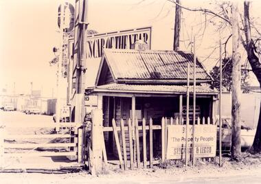
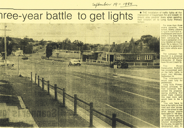
Newspaper - LONG GULLY HISTORY GROUP COLLECTION: INSTALLATION OF TRAFFIC LIGHTS EAGLEHAWK RD/CREETH ST
... Traffic Lights Eaglehawk Rd/Creeth St... Long Gully Primary School... The Road Construction Authority... Ted Coleman... Bendigo City...History House 11 Mackenzie Street Bendigo goldfields BENDIGO History long gully history group The Long Gully History Group - Installation of Traffic Lights Eaglehawk Rd/Creeth St Long Gully Primary School The Road Construction Authority Ted Coleman Bendigo City Council Rite-way Copy of a newspaper article titled three-year battle to get lights printed on yellow paper. ...Copy of a newspaper article titled three-year battle to get lights printed on yellow paper. Date written at the top is September 19 - 1984.Photo shows Eaglehawk Rd with a man crossing the street and a car going past. A tractor is on the corner. The accompanying article mentions that residents have been campaigning to get the lights for over three years.bendigo, history, long gully history group, the long gully history group - installation of traffic lights eaglehawk rd/creeth st, long gully primary school, the road construction authority, ted coleman, bendigo city council, rite-way -
 Greensborough Historical Society
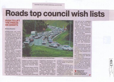
Newspaper Clipping, Diamond Valley Leader, Roads top council wish lists, 29/06/2016
... traffic...north east link...banyule council...metropolitan ring road...banyule city...Greensborough Historical Society 34A Glenauburn Road Lower Plenty Lower Plenty melbourne Traffic issues in Banyule and surrounding areas are discussed. traffic north east link banyule council metropolitan ring road banyule city council News clipping, black text and colour image Roads top council wish lists Newspaper Clipping Diamond Valley Leader ...Traffic issues in Banyule and surrounding areas are discussed.News clipping, black text and colour imagetraffic, north east link, banyule council, metropolitan ring road, banyule city council -
![Flyer - Leaflet, Montmorency Train Station: Call to action [Oct. 2020], 2020_10](/media/collectors/4f729f5697f83e03086015b8/items/6014f1be2bef110c704f4c77/item-media/6014f2592bef110c704f5110/item-fit-380x285.jpg?cb=6) Greensborough Historical Society
Greensborough Historical SocietyFlyer - Leaflet, Montmorency Train Station: Call to action [Oct. 2020], 2020_10
... Greensborough Historical Society 34A Glenauburn Road Lower Plenty Lower Plenty melbourne The Montmorency Train Station Group is a group of local people concerned about the relocation of Montmorency Station and the impact this will have on local residents, traffic, flora and fauna, as well as the impact on train services during upgrade works. hurstbridge rail line montmorency station montmorency train station group 2 page leaflet, colour images and text. Montmorency Train Station: Call to action [Oct. 2020] Flyer Leaflet Banyule City ...The Montmorency Train Station Group is a group of local people concerned about the relocation of Montmorency Station and the impact this will have on local residents, traffic, flora and fauna, as well as the impact on train services during upgrade works.2 page leaflet, colour images and text.hurstbridge rail line, montmorency station, montmorency train station group -
 Greensborough Historical Society
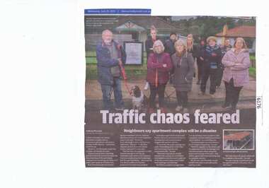
Newspaper Clipping, Diamond Valley Leader, Traffic chaos feared, 26/06/2019
... Greensborough Historical Society 34A Glenauburn Road Lower Plenty Lower Plenty melbourne A plan to develop a six-storey apartment complex next to Greensborough station will cause a "chaotic traffic disaster", concerned residents say. greensborough station apartment complex poulter avenue greensborough banyule city council News article 1 page, black text and colour image. ...A plan to develop a six-storey apartment complex next to Greensborough station will cause a "chaotic traffic disaster", concerned residents say.News article 1 page, black text and colour image.greensborough station, apartment complex, poulter avenue greensborough, banyule city council -
 Eltham District Historical Society Inc
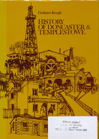
Book, City of Doncaster and Templestowe, History of Doncaster & Templestowe by Graham Keogh, 1975
... History of the City of Doncaster and Templestowe, beginning with first settlers on Bulleen and Templestowe rivers, including gold seekers, general development 1900-1945, expansion, road problem, disaster of 1962, traffic problems, Warrandyte State Park, historical research. photos index...Eltham District Historical Society Inc 728 Main Rd Eltham melbourne History of the City of Doncaster and Templestowe, beginning with first settlers on Bulleen and Templestowe rivers, including gold seekers, general development 1900-1945, expansion, road problem, disaster of 1962, traffic problems, Warrandyte State Park, historical research. photos index doncaster templestowe bulleen warrandyte ISBN 0959948716 466 p. ...History of the City of Doncaster and Templestowe, beginning with first settlers on Bulleen and Templestowe rivers, including gold seekers, general development 1900-1945, expansion, road problem, disaster of 1962, traffic problems, Warrandyte State Park, historical research. photos index466 p.ISBN 0959948716doncaster, templestowe, bulleen, warrandyte -
 Eltham District Historical Society Inc
Photograph, Fitzsimons Lane Bridge over Yarra River between Eltham and Templestowe, c.1966, 1966c
... traffic roll over the new Yarra bridge linking Bolton Street, Eltham, with Fitzsimons Lane, Templestowe. Over the week-end many “bridge watchers” who were making one of their periodic inspections of the progress on the new bridge found to their surprise that they could drive over it, so that people who had gone for a run out to Eltham suddenly found themselves wandering through Templestowe and Doncaster. By Monday the word of the bridge’s opening had got around sufficiently for many regular travellers to the city...traffic roll over the new Yarra bridge linking Bolton Street, Eltham, with Fitzsimons Lane, Templestowe. Over the week-end many “bridge watchers” who were making one of their periodic inspections of the progress on the new bridge found to their surprise that they could drive over it, so that people who had gone for a run out to Eltham suddenly found themselves wandering through Templestowe and Doncaster. By Monday the word of the bridge’s opening had got around sufficiently for many regular travellers to the city ...The bridge over the Yarra River was initially opened September 22nd, 1961. Newspaper reports at the time of opening stated it linked Bolton Street, Eltham, with Fitzsimons Lane, Templestowe. In 1955 the Country Roads Board (CRB) produced survey plans that showed proposed land acquisition for the future bridge and road approaches. The 1955 plan shows that it was proposed to connect Fitzsimons Lane with Bolton Street in Eltham by a diagonal road across the river. The road connection would then continue along Bolton Street to Main Road. Prior to construction of the bridge the CRB modified the proposal significantly so that there was a new road parallel with Bolton Street and then curving to join Main Road at what was then its intersection with Old Eltham Road. This involved significantly more land acquisition and altered the pattern of land subdivision through this corridor. Initially the new road was just a single two-way carriageway as it would have required a significant widening of the cutting on the Shire of Eltham side of the river. The road was officially un-named but was known locally as the Eltham-Templestowe Road. The 1966 Melway street directory and other 1960s editions also listed the road as the Eltham-Templestowe Road. In December 1970, Eltham Shire Council, in pursuance of the provisions of the Local Government Act, named it Templestowe Road. The road was renamed Fitzsimons Lane around 1984 in conformity with the section south of the river. In 1991 a new bridge was built to the west of the original bridge. Fitzsimons Lane was widened to four traffic lanes although on the Eltham side this was done within the limits of the existing cutting. NEW BRIDGE STARTS THEM EXPLORING Without any fanfares, Country Roads Board workmen on Friday afternoon put the finishing touches to the approaches, removed the barricades, and let the traffic roll over the new Yarra bridge linking Bolton Street, Eltham, with Fitzsimons Lane, Templestowe. Over the week-end many “bridge watchers” who were making one of their periodic inspections of the progress on the new bridge found to their surprise that they could drive over it, so that people who had gone for a run out to Eltham suddenly found themselves wandering through Templestowe and Doncaster. By Monday the word of the bridge’s opening had got around sufficiently for many regular travellers to the city from Eltham and beyond to vary the monotony by going to town via Templestowe and Kew instead of through Heidelberg. They were surprised at the distances – about 3 ½ miles from Eltham to Templestowe, 6 miles from Eltham Shire hall to the Lower Heidelberg Road-Banksia Street intersection. NEW NEIGHBOURS For people on both sides of the river, the new bridge has turned distant friends into near neighbours. A Greensborough man on Sunday took 35 minutes to reach the home of a friend in East Doncaster, but the return trip over the new bridge took only 17 minutes. It will be some time yet before most people work out the possibilities in shorter and quicker trips form the north-eastern areas to the eastern and south-eastern suburbs. The coming of the warmer months will soon teach many, though the short cuts to Peninsular beaches and eastern suburban drive-ins. And before very long it is likely there will be a Tramways bus running from Templestowe to Eltham station. NEW BRIDGE STARTS THEM EXPLORING (1961, September 27). The Diamond Valley News (News clipping held in SEA_74-1_047) The previously un-named road between Main Road and Yarra River, Eltham South, east of Bolton Street was named Templestowe Road, December 15, 1970 NAMING OF STREETS AND ROADS. (1970, December 15). The Diamond Valley News (News clipping held in SEA_74-2_022)Black and white photographManufacturer's marks: Polaroid, Batch #J62K181 (Sep 1966).infrastructure, shire of eltham infrastructure, bridge, fitzsimons lane bridge, polaroid, yarra river