Showing 27 items matching "civic precinct"
-
 Victorian Interpretive Projects Inc.
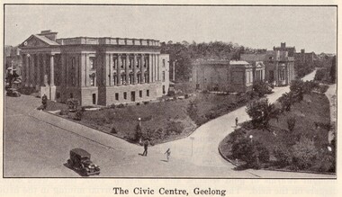
Image, Geelong, 1934, 1934
... the Geelong Civic Precinct in 1934. ... of multi-storey buildings that made up the Geelong Civic Precinct ...The seaside town of Geelong is the second largest city in Victoria, Australia.An image of a number of multi-storey buildings that made up the Geelong Civic Precinct in 1934. geelong -
 Ballarat Heritage Services
Digital photograph, Lisa Gervasoni, Portland, c2015
... civic precinct... Office goldfields portland heritage building bluestone civic ...portland, heritage, building, bluestone, civic precinct -
 Ringwood and District Historical Society
Photograph, Composite Aerial Views of Ringwood, Victoria - 1972
... precinct, Civic Centre precinct, Eastland, Mount Dandenong Road... precinct, Civic Centre precinct, Eastland, Mount Dandenong Road ...Two composite black & white aerial photographs with north-facing view over Maroondah Highway, including Railway Station precinct, Civic Centre precinct, Eastland, Mount Dandenong Road, Bedford Road, Ringwood Street, Warrandyte Road, Mullum Road, Loughnan's Road.Department of Crown Lands and Survey. Maroondah Highway Project - Run 3 - 20.1.72 - 3,900' ASL. -
 Greensborough Historical Society
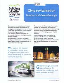
Folder, Banyule City Council, Civic Revitalisation: Ivanhoe and Greensborough: building a better Banyule, 2015_06
... of the Ivanhoe civic precinct and the development of One Flintoff Street... on the redevelopment of the Ivanhoe civic precinct and the development of One ...This folder contains information on the redevelopment of the Ivanhoe civic precinct and the development of One Flintoff Street Greensborough as Council's offices and service centre. The Greensborough centre will be built over the Watermarc building.Black spiral bound folder with clear cover, containing a collection of publications with text and colour images.banyule city council, ivanhoe, greensborough, one flintoff, watermarc -
 City of Whittlesea
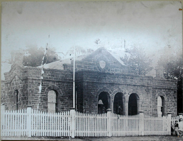
Photograph (item) - Photographs - Buildings, Epping Shire Hall
... /1985). Part of Epping Civic Precinct Heritage Conservation... of Epping Civic Precinct Heritage Conservation Area - 'the building ...Image - Epping Shire Hall, c 1905 (F Coote) The Shire Hall was erected by Thomas Mitchell in 1871, at a cost of 628 Pounds. It served as council chambers and offices, courthouse, public meeting room and dance hall. (Wuchatsch & Hawke, 1988/1985). Part of Epping Civic Precinct Heritage Conservation Area - 'the building reverted to its original role in 1939 when Epping again became the seat of the Whittlesea Council'epping shire council, whittlesea council, epping police station -
 Kew Historical Society Inc
Photograph - Kew City Hall, Ron Setford, 1960
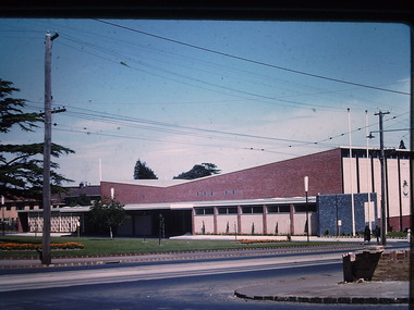
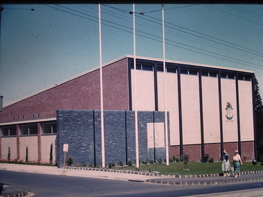
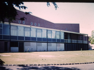
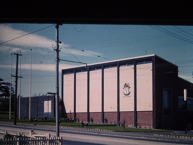
... an entire civic precinct. This was representative of a widely-held... as the initial phase in a scheme to develop an entire civic precinct ...Ron Setford and his wife Grace Setford lived in Tanner Avenue, East Kew, from c.1946 to c.1995. A keen photographer, he recorded the changing face of Kew over a 20 year period. Apart from 30 photographs of built structures and places in Kew dating from 1960 and 1961, 145 of his 35mm colour slides chronicle the development of the Eastern Freeway through the Yarra Valley over a five year period from c.1972 to c.1977. This important collection was donated to the Society by his granddaughter in 2025.This collection of 175 35mm slides is of local and statewide significance, owing to its subject matter, particularly the major development of road transport infrastructure during the 1970s with the construction of the Eastern Freeway. The photographer also took care to annotate and date most of his slides which enable the researcher to pinpoint temporal and spatial locations.The Kew City Hall in Cotham Road, designed by Harold Bartlett, was intended as the initial phase in a scheme to develop an entire civic precinct. This was representative of a widely-held belief, of the immediate post-war era, that a district's civic centre should be precisely that – not just a single grand building for official use, but a dedicated precinct providing a range of community facilities as well as an administrative function. The Kew masterplan was later abandoned. The City Hall was designed to cater for public or official functions. Its interior had a small stage at one end for intimate theatrical productions, a larger stage at the other (with sunken orchestra pit) for musical performances, plus the most up-to-date equipment for live TV transmission."Kew Town Hall"ron setford, photographs -- kew (vic.) -- 1960s, kew town hall -
 Kew Historical Society Inc
Photograph - Kew City Hall, Ron Setford, 1960
... an entire civic precinct. This was representative of a widely-held... as the initial phase in a scheme to develop an entire civic precinct ...Ron Setford and his wife Grace Setford lived in Tanner Avenue, East Kew, from c.1946 to c.1995. A keen photographer, he recorded the changing face of Kew over a 20 year period. Apart from 30 photographs of built structures and places in Kew dating from 1960 and 1961, 145 of his 35mm colour slides chronicle the development of the Eastern Freeway through the Yarra Valley over a five year period from c.1972 to c.1977. This important collection was donated to the Society by his granddaughter in 2025.This collection of 175 35mm slides is of local and statewide significance, owing to its subject matter, particularly the major development of road transport infrastructure during the 1970s with the construction of the Eastern Freeway. The photographer also took care to annotate and date most of his slides which enable the researcher to pinpoint temporal and spatial locations.The Kew City Hall in Cotham Road, designed by Harold Bartlett, was intended as the initial phase in a scheme to develop an entire civic precinct. This was representative of a widely-held belief, of the immediate post-war era, that a district's civic centre should be precisely that – not just a single grand building for official use, but a dedicated precinct providing a range of community facilities as well as an administrative function. The Kew masterplan was later abandoned. The City Hall was designed to cater for public or official functions. Its interior had a small stage at one end for intimate theatrical productions, a larger stage at the other (with sunken orchestra pit) for musical performances, plus the most up-to-date equipment for live TV transmission.Nilron setford, photographs -- kew (vic.) -- 1960s, kew town hall -
 Kew Historical Society Inc
Photograph - Kew City Hall, Ron Setford
... an entire civic precinct. This was representative of a widely-held... in a scheme to develop an entire civic precinct ...Ron Setford and his wife Grace Setford lived in Tanner Avenue, East Kew, from c.1946 to c.1995. A keen photographer, he recorded the changing face of Kew over a 20 year period. Apart from 30 photographs of built structures and places in Kew dating from 1960 and 1961, 145 of his 35mm colour slides chronicle the development of the Eastern Freeway through the Yarra Valley over a five year period from c.1972 to c.1977. This important collection was donated to the Society by his granddaughter in 2025.This collection of 175 35mm slides is of local and statewide significance, owing to its subject matter, particularly the major development of road transport infrastructure during the 1970s with the construction of the Eastern Freeway. The photographer also took care to annotate and date most of his slides which enable the researcher to pinpoint temporal and spatial locations.The Kew City Hall in Cotham Road, designed by Harold Bartlett, was intended as the initial phase in a scheme to develop an entire civic precinct. This was representative of a widely-held belief, of the immediate post-war era, that a district's civic centre should be precisely that – not just a single grand building for official use, but a dedicated precinct providing a range of community facilities as well as an administrative function. The Kew masterplan was later abandoned. The City Hall was designed to cater for public or official functions. Its interior had a small stage at one end for intimate theatrical productions, a larger stage at the other (with sunken orchestra pit) for musical performances, plus the most up-to-date equipment for live TV transmission.Nilron setford, photographs -- kew (vic.) -- 1960s -
 Greensborough Historical Society
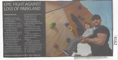
Newspaper Clipping, Diamond Valley Leader, Epic Fight Against Loss of Parkland, 27/03/2019
... Civic Drive recreational precinct, but many might not be aware... to Greensborough's new $13 million Civic Drive recreational precinct ...Families are flocking to Greensborough's new $13 million Civic Drive recreational precinct, but many might not be aware of the 12 year fight involved in ensuring its creation.News article 1 page, black text.greensborough, civic drive greensborough, playgrounds - greensborough, parks - greensborough -
![Photograph - Digital image, Civic Centre [Greensborough], 02/05/2013](/media/collectors/4f729f5697f83e03086015b8/items/5729b7242162f108e8de0add/item-media/5729b7552162f108e8de1585/item-fit-380x285.jpg) Greensborough Historical Society
Greensborough Historical SocietyPhotograph - Digital image, Civic Centre [Greensborough], 02/05/2013
... These three photographs of the Civic Centre precinct... of the Civic Centre precinct, including the Diamond Valley Library ...These three photographs of the Civic Centre precinct, including the Diamond Valley Library; were taken in 2013 to show changes over 40 years; based on Ron Reynold’s sketches in the 1973 publication 'Greensborough and Greenhills' published by Cypress Books. Built in the 1970s, the Civic Centre was originally the offices of the Shire of Diamond Valley but is now the offices of the Shire of Nillumbik.Digital copy of 3 colour photographs.greensborough and greenhills, shire of diamond valley, shire of nillumbik, ron reynolds -
 Kew Historical Society Inc
Plaque, Kew City Hall : Opened by The Hon H.E. Bolte M.L.A. Premier of Victoria 23rd April 1960 : Cr H.H. Ferguson J.P. Mayor, 1960
... proposed an entire civic precinct, of which a large public hall... decades earlier – and plans for a civic precinct were drawn up ...The Municipality of Kew was proclaimed on 19 December 1860, then upgraded to a Borough (1863), a Town (1910) and finally a City (1921). From 1865, its offices were based in the former Athenaeum Hall in Walpole Street, which, although extended in 1883, inevitably became inadequate. Plans for a new purpose-built Town Hall were first mooted in the late 1880s, but fell prey to six subsequent decades of debate. During that time, many sites were considered and rejected, and several schemes prepared. Finally, in 1945, it was resolved to build a new civic centre as a war memorial. The council acquired Southesk, a mansion on the south-west corner of Cotham Road and Charles Street – first mooted as a possible Town Hall site two decades earlier – and plans for a civic precinct were drawn up by John Scarborough. The project stalled until 1957, when a Town Hall Committee was formed and a new architect appointed: Harold Bartlett of Leith & Bartlett. He also proposed an entire civic precinct, of which a large public hall would constitute Stage One. Designed to accommodate almost any public or official function, the space had had a small stage at one end for intimate theatrical productions, a larger stage at the other (with operable sunken orchestra pit) for musical performances, plus the most up-to-date equipment for live TV transmission. The building, befitting its original intent as a war memorial, was also to include a sculpted monument, for which a separate design competition was held. First prize went to George H Allen (1900-1972), long-time head of the Sculpture Department at RMIT and a former war artist himself (the only one, in fact, to have worked in the medium of sculpture). At the time of the Kew project, Allen was best known for his Cenotaph at the Shrine of Remembrance (1955) and a controversial abstract sculpture at Hume House in William Street (1957). Tenders for the new hall were called and the contract (worth £104,986) was awarded to H F Yuncken. The foundation stone was laid by the Mayor, Cr F C O'Brien, on 1 June 1959. Completion (initially scheduled for October) was delayed by the unavailability of certain materials; it was barely finished in time for the official opening (by Premier Henry Bolte) on 23 April 1960. The war memorial was unveiled two days later (Anzac Day) by Bolte's deputy, the Hon A G Rylah. Fittingly, that year also marked Kew's municipal centenary, and many celebratory events were held in and around the new civic centre in December, including a special council meeting (attended by the Prime Minister), a tree planting ceremony and a youth ball. Source: Survey of Built Heritage in Victoria: Stage Two (Built Heritage Pty Ltd., 2010)Plaque commemorating the opening of a new town hall in KewMetal plaque recording the official opening of the Kew City Hall, 23rd April 1960. This plaque was given to the Kew Historical Society in 1991 by the former City of Kew.Kew City Hall / Opened by / The Hon. H.E. Bolte M.L.A. / Premier of Victoria / 23rd April 1960 / Cr. H.G. Ferguson J.P. - Mayor.kew city hall, foundation stones - kew (vic), sir henry bolte, local government -- kew (vic.) -
 Kew Historical Society Inc
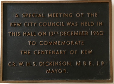
Plaque, A Special Meeting of the Kew City Council Was Held in This Hall on 13th December 1960 to Commemorate the Centenary of Kew : Cr. W.H.S. Dickinson M.B.E., J.P. Mayor, 1960
... proposed an entire civic precinct, of which a large public hall... decades earlier – and plans for a civic precinct were drawn up ...The Municipality of Kew was proclaimed on 19 December 1860, then upgraded to a Borough (1863), a Town (1910) and finally a City (1921). From 1865, its offices were based in the former Athenaeum Hall in Walpole Street, which, although extended in 1883, inevitably became inadequate. Plans for a new purpose-built Town Hall were first mooted in the late 1880s, but fell prey to six subsequent decades of debate. During that time, many sites were considered and rejected, and several schemes prepared. Finally, in 1945, it was resolved to build a new civic centre as a war memorial. The council acquired Southesk, a mansion on the south-west corner of Cotham Road and Charles Street – first mooted as a possible Town Hall site two decades earlier – and plans for a civic precinct were drawn up by John Scarborough. The project stalled until 1957, when a Town Hall Committee was formed and a new architect appointed: Harold Bartlett of Leith & Bartlett. He also proposed an entire civic precinct, of which a large public hall would constitute Stage One. Designed to accommodate almost any public or official function, the space had had a small stage at one end for intimate theatrical productions, a larger stage at the other (with operable sunken orchestra pit) for musical performances, plus the most up-to-date equipment for live TV transmission. The building, befitting its original intent as a war memorial, was also to include a sculpted monument, for which a separate design competition was held. First prize went to George H Allen (1900-1972), long-time head of the Sculpture Department at RMIT and a former war artist himself (the only one, in fact, to have worked in the medium of sculpture). At the time of the Kew project, Allen was best known for his Cenotaph at the Shrine of Remembrance (1955) and a controversial abstract sculpture at Hume House in William Street (1957). Tenders for the new hall were called and the contract (worth £104,986) was awarded to H F Yuncken. The foundation stone was laid by the Mayor, Cr F C O'Brien, on 1 June 1959. Completion (initially scheduled for October) was delayed by the unavailability of certain materials; it was barely finished in time for the official opening (by Premier Henry Bolte) on 23 April 1960. The war memorial was unveiled two days later (Anzac Day) by Bolte's deputy, the Hon A G Rylah. Fittingly, that year also marked Kew's municipal centenary, and many celebratory events were held in and around the new civic centre in December, including a special council meeting (attended by the Prime Minister), a tree planting ceremony and a youth ball. Source: Survey of Built Heritage in Victoria: Stage Two (Built Heritage Pty Ltd., 2010)Historically significant commemorative plaqueMetal plaque relating to special Council meeting to mark centenary of Kew, 13th December 1960. This plaque was given to the Kew Historical Society in 1991 by the former City of Kew.A Special Meeting Of The / Kew City Council Was Held In / This Hall On 13th December 1960 / To Commemorate / The Centenary of Kew / Cr. W.H.S. Dickinson, M.B.E., J.P., / Mayorkew city hall, foundation stones - kew (vic), cr. w.h.s. dickinson, local government -- kew (vic.) -
 Port Melbourne Historical & Preservation Society
Photograph - Police Station and Court House, 111 Bay Street and Sargeant's house, 187 Graham Street, Port Melbourne, Janet and Allen Walsh, 1973
Shot in 1973 with particular interest in architectureSet of 31 photographs taken in June and July 1973 Law and Order precinct Bay St. Police and CourthouseIdentified and dated on back in inkbuilt environment - commercial, built environment - domestic, built environment - industrial, built environment - civic, janet walsh, allen walsh, bay street, law and order, police, courthouse -
 Hume City Civic Collection
Photograph, 1980s
The Sunbury Gun was placed in this airconditioned room in the Village Green after it was restored. A coloured photograph of the Sunbury Gun in the Village Green precinct.gun, sunbury, village green, starkie fountain, fountains, clarke, william (sir), russell, janet (lady), starkie, joseph, war memorials, monuments and statues, church of england, churches, george evans collection -
 Hume City Civic Collection
Photograph, Late 1980's
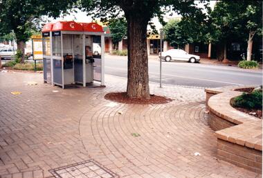
The series of seven photographs highlight examples of vandalism within the town centre precinct. Most of the vandalism occurred on public buildingsA coloured photograph of public telephones and the taxi rank in Evans Street. The telephone directories have been torn up an thrown around the brick pavement along with other litter. The trunk of an elm tree is in the middle of the photograph.vandalism, evans street, taxi ranks, public telephones, telstra, telecom, george evans collection -
 Hume City Civic Collection
Photograph, Late 1980's
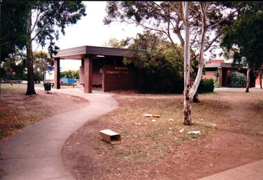
The series of seven photographs highlight examples of vandalism within the town centre precinct. Most of the vandalism occurred on public buildings. The toilet block was demolished in the late 1990's to make way for further expansion of the retail shopping centre in Sunbury.A coloured photograph of the Sunbury Comfort Station which was erected on a section of public land in Evans Street between the post office and Sunbury Shopping Square. The brown brick building has an open porch on one side and a curved concrete path leads from the street to the building. A smaller block is in the background and a grassed ared with trees is in the foreground with rubbish thrown across the grass.vandalism, public toilet blocks, evans street, sunbury comfort station, shire of bulla, george evans collection -
 Hume City Civic Collection
Photograph, post 1972
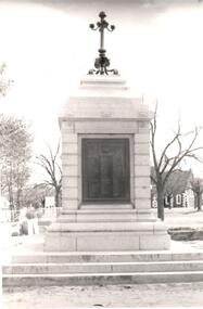
The Sunbury War Memorial is situated on a triangular section of land which was once at the intersection of Barkly and Stawell Streets. The precinct is also the site of the Rupertswood Gun and the Starkey Fountain. All are important historical exhibits related to Sunbury's history.A black and white photograph of a front view of the Sunbury War Memorial. The memorial has been placed on 3 steps at the base with a metal tablet set in a stone surround. There is a decorative metal pole at the top of the memorial. St. Mary's Church is in the background.war memorials, village green, st. mary's church, george evans collection -
 Hume City Civic Collection
Photograph, 1920-1929
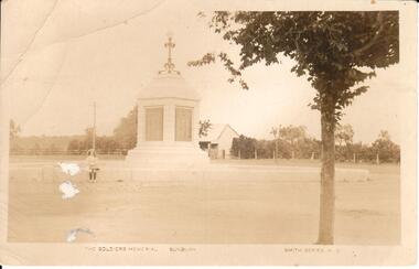
A sepia photograph of a soldier's memorial at sunbury at the intersection of Macedon Street, Barkly Street and Stawell Street before it was moved. Stawell Street was closed off and now forms part of the Village Green precinct. Unmounted postcardmonuments and memorials, soldiers, armed forces, returned servicepeople, returned servicemens league, gregor, alex, billinghurst, beryl, francey, sandra, world war 2, world war 1, sunbury, macedon street, stawell street, village green, george evans collection -
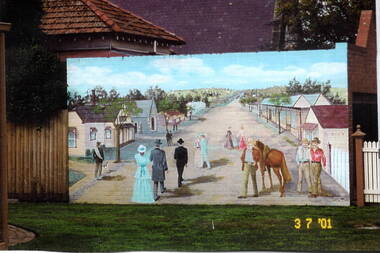 Hume City Civic Collection
Photograph, Sunbury Mural, 3rd July 2001
The mural of the artist's image of early Sunbury was painted on the garage wall of the Sunbury Presbytery. It could be viewed from the former court house garden. The first businesses opened in Sunbury in Macedon Street between Jacksons Creek and Jackson Street. The view in the mural is looking east towards Jacksons Creek.When the railway service reached Sunbury in 1859, the business area then relocated from Macedon Street to the Evans and O'Shanassy Streets precinct. Some businesses still exist at the original Macedon Street site.A coloured scanned photograph of a mural which was painted on a brick wall.murals, early sunbury, macedon street -
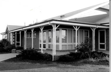 Hume City Civic Collection
Photograph, Bulla Community Centre, c1980s
The building is the Bulla Community Centre, which replaced an older hall that was situated in the Bulla Sports Ground precinct in Greene Street. Over the years many community activities have been staged within the precinct such as district school sports, local dances and community social group functions.A black and white photograph of a brick building with large windows and a return verandah.bulla community centre, bulla township -
 Kew Historical Society Inc
Archive (Sub-series) - Subject File, Kew Court House 1986-1989, 1986
Various partiesReference, Research, InformationSecondary Values (KHS Imposed Order)Subject file containing information relating to the Kew Post Office complex, including the Kew Court House and the Police Station. The correspondence between parties included the City of Kew, the Kew Historical Society, and the Victorian Government. Initially the correspondence related to the proposed use of the Court House as a Centre for the Society as it was being forced to vacate the Copy Shop (q.v) in Walpole Street due to its impending demolition. Later correspondence relates to the proposed sale of the Court House by the Victorian Government.kew - history, kew court house, kew police station, heritage campaigns - kew (vic)kew - history, kew court house, kew police station, heritage campaigns - kew (vic) -
Kew Historical Society Inc
Archive (Sub-series) - Subject File, Kew Court House - 2000-2005, 2000
Various partiesReference, Research, InformationSecondary Values (KHS Imposed Order)Subject file containing information about the heritage significance of the Kew Court House (and Police Station) in High Street, Kew. Most of the file contains correspondence between a number of interested parties including the Kew Historical Society which was leading the campaign to have the building/precinct preserved and used for community purposes. Letters and submissions include those from the Department of Treasury & Finance, Ray Tonkin (Heritage Victoria), Dr. Robert Dean MLA, Judith Voce, Hon David Davis MLC, John Lenders MP, Hon John Thwaites, Andrew McIntosh MLA and officers of the Kew Historical Society. The file also contains records of interview and memos and meeting minutes relating to the campaign.kew - history, kew court house, kew police station, heritage campaigns - kew (vic)kew - history, kew court house, kew police station, heritage campaigns - kew (vic) -
Kew Historical Society Inc
Journal, Kewriosity : July 1992
City of Kew Ward boundaries [map] / p1. Council election Saturday 1st August, 1992 Prospect Ward / p1. Letter from resident 'waste management' / Katrine Keuneman p2. Kew Junction Commercial Centre Precinct 8 / p2. Kew and Hawthorn a place for cyclists / p2. Mayor's Comment / Cr Daryl Oldaker p3. Come rain, hail or sunshine [school crossings] / p3 Kew Lioness Club / p3. Diary Dates for July/August pp.4-5. In Brief [Sold Kew Post Office; Help your postie deliver your mail; Carnsworth Nursing Home volunteers] / p4. In Brief continued [Kew Bowling Club; The Asthma Foundation of Victoria; Work at home as a family day caregiver; Kew Band; Kew Senior Citizens: Lions Club Opportunity Shop] / p5. My feelings on Kew / Chris Howlett p6. Youth homelessness / p6. Kew Festival / p6. Victorian Disabled Skiers' Assoc./ p7. Midwifery commemoration / p7. Vaccination against Haemophilus Influenzae Type B Disease / p7. Quit Quiz / p7. Our [Four Seasons] window [by Alan Sumner, in Kew Library] / p7. Pictures of Kew Kew High School students; Dedication of Burke Hall oval to past Mayor of Kew, the late Jack Gervasoni; Volunteers Reception; Bryan Berry] p8.Kewriosity was a local newsletter combining Kew Council and community news. It was published between November 1983 and June 1994, replacing an earlier Kewriosity [broad] Sheet (1979-84). In producing Kewriosity, Council aimed to provide a range of interesting and informative articles covering its deliberations and decision making, together with items of general interest and importance to the Kew community and information not generally available through daily media outlets.non-fictionCity of Kew Ward boundaries [map] / p1. Council election Saturday 1st August, 1992 Prospect Ward / p1. Letter from resident 'waste management' / Katrine Keuneman p2. Kew Junction Commercial Centre Precinct 8 / p2. Kew and Hawthorn a place for cyclists / p2. Mayor's Comment / Cr Daryl Oldaker p3. Come rain, hail or sunshine [school crossings] / p3 Kew Lioness Club / p3. Diary Dates for July/August pp.4-5. In Brief [Sold Kew Post Office; Help your postie deliver your mail; Carnsworth Nursing Home volunteers] / p4. In Brief continued [Kew Bowling Club; The Asthma Foundation of Victoria; Work at home as a family day caregiver; Kew Band; Kew Senior Citizens: Lions Club Opportunity Shop] / p5. My feelings on Kew / Chris Howlett p6. Youth homelessness / p6. Kew Festival / p6. Victorian Disabled Skiers' Assoc./ p7. Midwifery commemoration / p7. Vaccination against Haemophilus Influenzae Type B Disease / p7. Quit Quiz / p7. Our [Four Seasons] window [by Alan Sumner, in Kew Library] / p7. Pictures of Kew Kew High School students; Dedication of Burke Hall oval to past Mayor of Kew, the late Jack Gervasoni; Volunteers Reception; Bryan Berry] p8.publications -- city of kew (vic.), kewriosity, council newsletters, community newsletters -
![Victorian era cottage, Derby Street [Kew]](/media/collectors/550653872162f11fb04854aa/items/658f5772101c4283c6ae47ff/item-media/658f57e4101c4283c6ae493a/item-fit-380x285.jpg) Kew Historical Society Inc
Kew Historical Society IncPhotograph - Victorian era cottage, Derby Street [Kew], c. 1965
The current site of the Kew Recreation Centre in High Street Kew previously housed the Kew Depot on the corner of Disraeli Street. In nearby Derby Street, a number of original Victorian era buildings were gradually replaced due to development of the Baths precinct and commercial development.This work forms part of the collection assembled by the historian Dorothy Rogers (1905-1973), donated to the Kew Historical Society by her son in 2015. The manuscripts, photographs, maps, and documents were sourced by her from both family and local collections or produced as references for her print publications. Many were directly used by Rogers in writing ‘Lovely Old Homes of Kew’ (1961) and 'A History of Kew' (1973), or the numerous articles on local history that she produced for suburban newspapers. Most of the photographs in the collection include detailed annotations in her hand. The Rogers Collection provides a comprehensive insight into the working habits of a historian from the 1960s to the 1970s. Small single fronted cottage in Derby Street, Kew. The weatherboard cottage has a block fronted facade, and a Victorian verandah with cast iron lace.Annotation verso: "House in Derby St., next to Kew Baths (Demolished?)"dorothy rogers, derby street (kew), victorian houses -- kew (vic.) -
![Victorian era cottage, Derby Street [Kew]](/media/collectors/550653872162f11fb04854aa/items/658f7ef19239cf6fd436d1fd/item-media/658f7f019239cf6fd436d25f/item-fit-380x285.jpg) Kew Historical Society Inc
Kew Historical Society IncPhotograph - Victorian era cottage, Derby Street [Kew], c. 1965
The current site of the Kew Recreation Centre in High Street Kew previously housed the Kew Depot on the corner of Disraeli Street. In nearby Derby Street, a number of original Victorian era buildings were gradually replaced due to development of the Baths precinct and commercial development.This work forms part of the collection assembled by the historian Dorothy Rogers (1905-1973), donated to the Kew Historical Society by her son in 2015. The manuscripts, photographs, maps, and documents were sourced by her from both family and local collections or produced as references for her print publications. Many were directly used by Rogers in writing ‘Lovely Old Homes of Kew’ (1961) and 'A History of Kew' (1973), or the numerous articles on local history that she produced for suburban newspapers. Most of the photographs in the collection include detailed annotations in her hand. The Rogers Collection provides a comprehensive insight into the working habits of a historian from the 1960s to the 1970s. Small single fronted cottage in Derby Street, Kew. The weatherboard cottage has a block fronted facade, and a Victorian verandah with cast iron lace.dorothy rogers, derby street (kew), victorian houses -- kew (vic.) -
![EJ Harvey, Motor Engineers, High Street [Kew East], circa 1925](/media/collectors/550653872162f11fb04854aa/items/586f9929d0ce2607f0b81f1a/item-media/586f99e0d0ce2607f0b8546f/item-fit-380x285.jpg) Kew Historical Society Inc
Kew Historical Society IncPhotograph - Photograph [copy], EJ Harvey, Motor Engineers, High Street [Kew East], circa 1925, c. 1925
The building was in High Street, Kew East between Clyde and Oswin Streets. The site is currently (2017) occupied by a canoe retailer.Rare and historic photograph of an early business in the Harp Village shopping precinctGarage - E.J. Harvey, Motor Engineers workshop, High Street, East Kew. The garage was on the corner of Clyde Street.Inscription reverse: "High Street, East Kew - present site of Harvey Phillips Retro Vision[*] shop. Gift of Edna Phillips. Edna loaned KHS the original photo and KHS had it copied." * Note - Harvey Phillips Retravision not Retro Vision].motor engineers (kew), garages (kew), e.j. harvey