Showing 1326 items matching "clear hills"
-
 Greensborough Historical Society
Genealogical Document, Michael Butler and family, 2017_
... ...clear hills...Later records and Titles give the address as Clear Hills near Greensborough. The location appears to be in Plenty....Later records and Titles give the address as Clear Hills near Greensborough. The location appears to be in Plenty. butler family michael butler clear hills plenty 17 pages, including family tree and copies of titles Michael Butler and family Genealogical Document ...Michael Butler and his family are recorded as living on the Plenty River in 1840. Later records and Titles give the address as Clear Hills near Greensborough. The location appears to be in Plenty.17 pages, including family tree and copies of titlesbutler family, michael butler, clear hills, plenty -
 Hume City Civic Collection
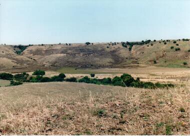
Photograph, c 1990s
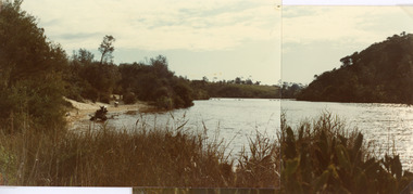
... A coloured photograph of a wide valley with cleared hills in the background. The tree lined creek or watercourse is across the middle distance of the image....'big bull' victorian volunteer forces george evans collection A coloured photograph of a wide valley with cleared hills in the background. The tree lined creek or watercourse is across the middle distance of the image. ...Canon Gully is situated about 2 km upstream from the railway bridge at Rupertswood. In 1864 it was the site for the military encampment of the Victorian Volunteer Forces. William Clarke allowed the military to stage the annual event on his property. Further encampments were held on this site in 1874 and 1877.A coloured photograph of a wide valley with cleared hills in the background. The tree lined creek or watercourse is across the middle distance of the image.canon gully, rupertswood estate, encampments, clarke, william j. t. 'big bull', victorian volunteer forces, george evans collection -
 Mt Dandenong & District Historical Society Inc.
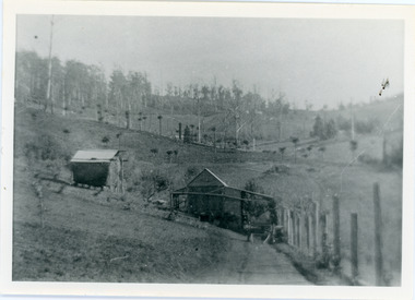
Photograph, View of the Kalorama Valley c1905
... Black and white photograph showing two small buildings in the foreground with cleared hills behind. Handwritten decription on back by John Lundy-Clarke...Black and white photograph showing two small buildings in the foreground with cleared hills behind. Handwritten decription on back by John Lundy-Clarke View of the Kalorama Valley c1905 Photograph Photograph ...John Lundy-Clarke grew up in the Kalorama/Mt Dandenong area and later in life (1972-74) began to write a comprehensive history of the area working from an original settlement map in an effort to cover all areas. This photograph c1905 is looking up from George Barber's house 'Forest Edge' on Barbers Road. 'Forest Edge' was built c1898 and was the home of George Barber and his wife Sarah Ann (nee Richardson). The buildings in the foreground are the stables and hayshed.Black and white photograph showing two small buildings in the foreground with cleared hills behind. Handwritten decription on back by John Lundy-ClarkeA 1905 view of the Kalorama Valley towards the Gap. Barbers stables in foreground with hayshed on left. Tait’s house in centre of picture with Logans in the same fold above the hayshed. “Kalorama” is centre of Gap with Paynter’s “Iona” on its left with stables to its left. It was from one of these trees on the top left that the runaway log was cut that leaped over Barbers Road (at the top edge of the cleared land) then over Logan’s house in one bound in 1930.george barber, sarah ann barber, john lundy-clarke, forest edge -
 Mt Dandenong & District Historical Society Inc.
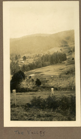
Photograph
... The land has been cleared. Hills are in the distance....The land has been cleared. Hills are in the distance. Photograph Photograph ...The photograph is from the album of Ivy Child and shows a view across the Kalorama Valley sometime between 1927 and 1932. Ivy May Child (1910 – 1989) was the daughter of Arthur Edward (Ted) Child (1878 – 1964) and Ethel May Madden (1888 – 1970). Ted Child was the son of Matthew Francis Child (1839 – 1933) and Martha Jeeves (1857 – 1926). He was the grandson of one of the early pioneers Francis Child. Ivy grew up on the family property on Childs Road and took many photographs. Most of these are glued into her photo album. The album covered the years from c1927 – 1932. Ivy married Henry William Burgess (1906 – 1968) in 1944. The photographs remain in their original state in the album with individual copies made. Sepia coloured photograph with a wire and pole fence in the foreground of a sweeping view across a valley. Numerous roof tops are visible in the distance. The land has been cleared. Hills are in the distance.Written below the photograph in the album: The Valleykalorama valley, kalorama, ivy child -
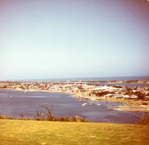 Lakes Entrance Historical Society
Photograph - North Arm. Lakes Entrance Victoria c1985, Fraser, Nancy
... Photo taken from cleared hill, Kalimna, in foreground. Bass Strait in distance. ...Photo taken from cleared hill, Kalimna, in foreground. Bass Strait in distance. ...Colour photograph of a bend in the North Arm. It shows the sports ground, eastern end of town. Jetties and hire boats at edge of lake. Photo taken from cleared hill, Kalimna, in foreground. Bass Strait in distance. Lakes Entrance Victoriawaterways, township -
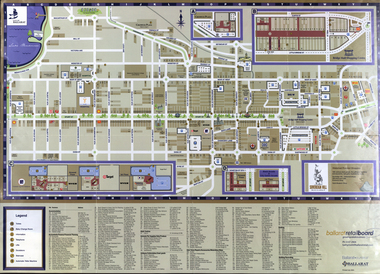 Federation University Historical Collection
Map, Eastern Ballarat (c) Retail and Business Guide, 2004
... hill...mount clear...Map of Ballarat East including Brown Hill, Mount Clear and Buninyong....brown hill mount clear mount helen buninyong university of ballarat Map of Ballarat East including Brown Hill, Mount Clear and Buninyong. ...Map of Ballarat East including Brown Hill, Mount Clear and Buninyong.brown hill, mount clear, mount helen, buninyong, university of ballarat -
 Hume City Civic Collection
Photograph, early 1990's
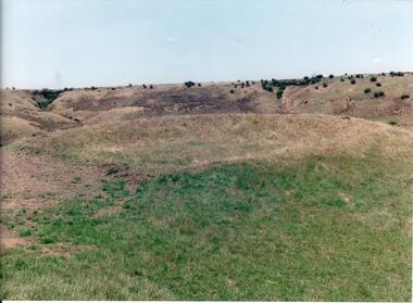
... It is situated on a cleared mound with small hills across the skyline....It is situated on a cleared mound with small hills across the skyline. Photograph ...The set of 20 photographs were taken of a number of archaeological sites in Sunbury of sacred sites and aboriginal rings. The photographs were included in a study of these sites which was published by the Shire of Bulla in the early 1990's.Site of an Aboriginal Ring near Sunbury. It is situated on a cleared mound with small hills across the skyline.aboriginal ring sites, george evans collection -
 Lakes Entrance Historical Society
Photograph - Lake Bunga, Fish Marie, 1980
... Vegetation on sides of lake, background hill cleared, seats along the shoreline, lake full and clean. ...Vegetation on sides of lake, background hill cleared, seats along the shoreline, lake full and clean. ...Two photographs stitched together to show a panoramic view.Colour photograph showing view of Lake Bunga, near Lakes Entrance, looking upstream from near the entrance. Tramway bridge almost gone. Some piles remain. Vegetation on sides of lake, background hill cleared, seats along the shoreline, lake full and clean. Lake Bunga Victoriabridges, waterways -
 Federation University Historical Collection
Photograph, Frank Wright on Beacon Hill, Great Malvern, 1934, 05/07/1934
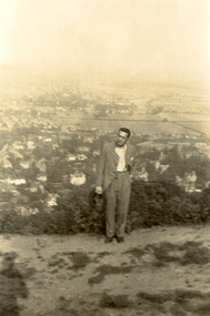
... Black and white photograph of a man dressed in a suit and standing in a cleared area on a hill with small shrubbery behind and then the far background is made up of a township and fields. ...The Frank Wright Medal at the Royal South Street competition is awarded to an individual recognized as making an outstanding contribution to brass music in Australia. frank wright conductor beacon hill great malvern Written in pencil on the back - Au, Frank Wright on Beacon Hill, Great Malvern, 5.7.34 Black and white photograph of a man dressed in a suit and standing in a cleared area on a hill with small shrubbery behind and then the far background is made up of a township and fields. ...Frank Wright was a renown resident of Smeaton, where he was born. He lived at Laura Villa, and attended Smeaton State School. His father William was a gold miner and his mother's name was Sarah. Their family won many singing and instrumental awards. Frank was tutored by Percy Code and was awarded a gold medal for the highest marks in the ALCM examinations in the British Colonies at the age of seventeen years. He became the Australian Open Cornet Champion by the age of eighteen. A year later, Frank conducted the City of Ballarat Band, and later the Ballarat Soldiers’ Memorial Band. He formed the Frank Wright Frisco Band and Frank Wright and his Coliseum Orchestra. These bands won many South Street awards, and Frank as conductor won many awards in the Australian Band Championship contest. In 1933 Frank Wright sailed to England to conduct the famous St Hilda’s Band and was later appointed Musical Director of the London County Council, where he organized many amazing concerts in parks, in and around the London district. He was made Professor of Brass and Military Band Scoring and conducted at the Guildhall of Music and Drama. Frank was often invited to adjudicate Brass Band Championships around Europe, in Australia, including South Street and in New Zealand. The Frank Wright Medal at the Royal South Street competition is awarded to an individual recognized as making an outstanding contribution to brass music in Australia.Black and white photograph of a man dressed in a suit and standing in a cleared area on a hill with small shrubbery behind and then the far background is made up of a township and fields. The man is Frank Wright and the place is Beacon Hill overlooking Great Malvern.Written in pencil on the back - Au, Frank Wright on Beacon Hill, Great Malvern, 5.7.34frank wright, conductor, beacon hill, great malvern -
 Ringwood and District Historical Society
Photograph, Plaque unveiled at Ringwood Eastern Metropolitan Regional Library, commemorating the Golden Jubilee of Ringwood's severance from Lilydale. 1974
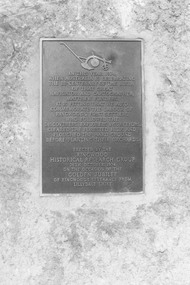
... Words written on Plaque: 'In this year, 1974, when Australia is celebrating the bi-centenary of the birth of that great navigator and cartographer, Mathew Flinders, it is fitting that we also commemorate the labour of Ringwood's first settlers who followed the discoverers, explorers and surveyors, cleared the forested hills and ploughed the hard ground before planting their orchards. ...Words written on Plaque: 'In this year, 1974, when Australia is celebrating the bi-centenary of the birth of that great navigator and cartographer, Mathew Flinders, it is fitting that we also commemorate the labour of Ringwood's first settlers who followed the discoverers, explorers and surveyors, cleared the forested hills and ploughed the hard ground before planting their orchards. ...Black and white photographWritten on back of photograph: "Plaque, 1970." Words written on Plaque: 'In this year, 1974, when Australia is celebrating the bi-centenary of the birth of that great navigator and cartographer, Mathew Flinders, it is fitting that we also commemorate the labour of Ringwood's first settlers who followed the discoverers, explorers and surveyors, cleared the forested hills and ploughed the hard ground before planting their orchards. Erected by the Ringwood Historical Research Group, 26th October 1974 on the occasion of the Golden Jubilee of Ringwood's severance from Lillydale Shire.' -
 Ringwood and District Historical Society
Photograph, Plaque, Ringwood Library, commemorating Golden Jubilee of Ringwood's severance from Lilydale Shire. 1974
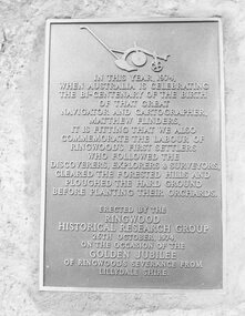
... Plaque reads: IN THIS YEAR, 1974, WHEN AUSTRALIA IS CELEBRATING THE BI-CENTENARY OF THE BIRTH OF THAT GREAT NAVIGATOR AND CARTOGRAPHER, MATTHEW FLINDERS, IT IS FITTING THAT WE ALSO COMMEMORATE THE LABOUR OF RINGWOOD'S FIRST SETTLERS WHO FOLLOWED THE DISCOVERERS, EXPLORERS & SURVEYORS, CLEARED THE FORESTED HILLS AND PLOUGHED THE HARD GROUND BEFORE PLANTING THEIR ORCHARDS. ...Ringwood and District Historical Society 125A Warrandyte Road Ringwood North melbourne Plaque reads: IN THIS YEAR, 1974, WHEN AUSTRALIA IS CELEBRATING THE BI-CENTENARY OF THE BIRTH OF THAT GREAT NAVIGATOR AND CARTOGRAPHER, MATTHEW FLINDERS, IT IS FITTING THAT WE ALSO COMMEMORATE THE LABOUR OF RINGWOOD'S FIRST SETTLERS WHO FOLLOWED THE DISCOVERERS, EXPLORERS & SURVEYORS, CLEARED THE FORESTED HILLS AND PLOUGHED THE HARD GROUND BEFORE PLANTING THEIR ORCHARDS. ...Black and white photograph of plaque set in rock outside Library.Plaque reads: IN THIS YEAR, 1974, WHEN AUSTRALIA IS CELEBRATING THE BI-CENTENARY OF THE BIRTH OF THAT GREAT NAVIGATOR AND CARTOGRAPHER, MATTHEW FLINDERS, IT IS FITTING THAT WE ALSO COMMEMORATE THE LABOUR OF RINGWOOD'S FIRST SETTLERS WHO FOLLOWED THE DISCOVERERS, EXPLORERS & SURVEYORS, CLEARED THE FORESTED HILLS AND PLOUGHED THE HARD GROUND BEFORE PLANTING THEIR ORCHARDS. ERECTED BY THE RINGWOOD HISTORICAL RESEARCH GROUP, 26TH OCTOBER, 1974 ON THE OCCASION OF THE GOLDEN JUBILEE OF RINGWOOD'S SEVERANCE FROM LILYDALE SHIRE Typed below photograph: "1974 - Plaque Ringwood Library." Written on rear of backing sheet: "Before the plaque was finally fitted in I had a new 1974 ten cent piece slipped in behind it. R. Pullin, Archivist, RHR Group." -
 Federation University Historical Collection
Plan, White Horse Range Ballarat, 1885, 06/1885
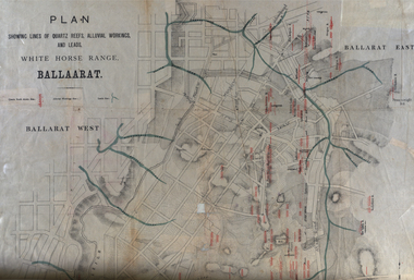
... Mines include Red Streak, New Chum, Tinworths, Woah Hawp, Normanby, Speedwell, Llanberris Extended, Llanberis, Last Chance, Major, Countess, Pioneer and a number of batteries along Main Road Hills include: Mount Clear, Pennyweight Hill, Sovereign Hill...Mines include Red Streak, New Chum, Tinworths, Woah Hawp, Normanby, Speedwell, Llanberris Extended, Llanberis, Last Chance, Major, Countess, Pioneer and a number of batteries along Main Road Hills include: Mount Clear, Pennyweight Hill, Sovereign Hill White Horse Range Ballarat, 1885 Plan Plan ...Two plans .1) Plan of the Ballarat Goldfields showing leads, rivers, streets and topography. Quartz reefs include: Yorkshire, Try Again, Promised Land, Western Slates, Norwegian, Robert's Lode, Finn's, Band and albion, Rothschild, Old Post Office, Queen Lode. Leads include: Navy jacks, Gays, Canadian, Prince Regent, Sailors Gully, White Horse, Little White Horse, Milkmans, Nightingale, Golden Point, Gravel Pits. Scale is 8 Chains to 1 inch .2) Plan showing lines of quartz reefs, alluvial workings and leads, White Horse Range, Ballarat. Leads include White Horse LEad, Little White Horse Lead, One Eye Gully, Terrible Lead, Sailor's Gully, Canadian Lead, Prince Regent Gully, Canadian Lead, Cavs Lead, Navy jacks Lead, Eureka Lead, Old Gravel Pits Lead, Gravel Pits Lead, Nightingale Lead, Malakoff Lead, Milkmans Lead, Redan Lead, Woolshed Lead, Jacksons Lead, Winters Lead, SCtochman's Lead, Canadian Lead. Reefs include: Promised Land, Daniash, Sir Garnet Wolsley, Norwegian, Rothschile, Band and Albion, Finns, Llanberis, Roberts Lode, Tynworths and Black Hill, Oregan, Yorkshire, Try Again, Yorkshire, Post Office, Clarke's, Western Slates, Black Slate, Danks Slates, Eastern Slates, Queen's Lode, Fire Brigade. Mines include Red Streak, New Chum, Tinworths, Woah Hawp, Normanby, Speedwell, Llanberris Extended, Llanberis, Last Chance, Major, Countess, Pioneer and a number of batteries along Main Road Hills include: Mount Clear, Pennyweight Hill, Sovereign Hillballarat, plan, white horse range, white horse, goldfields, mines, reefs, indicators, leigh river, cgt, tinworth, mining -
 Southern Sherbrooke Historical Society Inc.
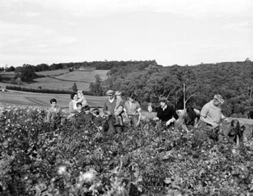
Photograph - Spykers family at Avonsleigh c.1960
... In the background there are low hills with cleared paddocks and forested areas. According to the National Archives of Australia: 'Land was life for nurseryman Theo Spykers and his ancestors who had tilled the soil for generations; good land to own and to pass on to sons and their sons. ...In the background there are low hills with cleared paddocks and forested areas. According to the National Archives of Australia: 'Land was life for nurseryman Theo Spykers and his ancestors who had tilled the soil for generations; good land to own and to pass on to sons and their sons. ...Black and white photo showing a large family group in a flower field. In the background there are low hills with cleared paddocks and forested areas. According to the National Archives of Australia: 'Land was life for nurseryman Theo Spykers and his ancestors who had tilled the soil for generations; good land to own and to pass on to sons and their sons. At 42 Theo had one and a half acres near Rotterdam for a prosperous nursery, but he could only rent it and his family was growing. So, in 1948, Theo left his wife and six children at their home and set off by himself for Australia. Within a year he had paid a deposit on a broken-down property of 35 acres in the Dandenong ranges. His family joined him and they started to rehabilitate their new property. Mr and Mrs Spykers and twelve of their thirteen children pick chrysanthemums for sale in Melbourne, a city of 1,750,000. The children are; Theo, 20; Gerald, 15; Niko, 8; Frank, 5; Adolf, 22; Corrie, 11; Ria, 18; Terisa, 4; Anthony, 7; Tommy, 2; Elly, 10; Bill, 16.' Mr & Mrs Spykers are each holding one of the smaller children. This farm was on the corner of Birds Rd and Avon Rd, Avonsleigh. On the NAA records, Theodorus Gerardus Spykers arrived in Melbourne on the Muiderkerk on 27th February 1948. Black and white photo showing 15 year old Gerald Spykers carrying bundles of chrysanthemums tied ready for market. He is at the family farm on the corner of Birds Rd and Avon Rd, Avonsleigh. -
 Warrnambool and District Historical Society Inc.
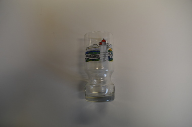
Souvenir - Souvenir Glass Tumbler, late 20th to early 21st centuries
... Hill. The glass has been sold as a tourist souvenir or as a memento for local people. This item is of minor interest as an example of a tourist souvenir of Warrnambool. Warrnambool Lighthouses Warrnambool Vic This is a clear ...This is a souvenir glass with an image of the Lower Lighthouse at Flagstaff Hill in Warrnambool. This lighthouse is one of two first situated at Flagstaff Hill in 1871, with the lower light being placed on the top of an obelisk that had been erected at an earlier date. The two lighthouses still operate today on Flagstaff Hill. The glass has been sold as a tourist souvenir or as a memento for local people.This item is of minor interest as an example of a tourist souvenir of Warrnambool.This is a clear glass circular tumbler with a heavy base and an indented section near the base where the hand grasps the glass. On one side of the glass is a multi-coloured sketch of a lighthouse.Warrnambool Vicwarrnambool lighthouses -
 Warrnambool and District Historical Society Inc.
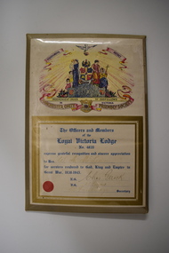
Certificate, Loyal Victoria Lodge, mid 1940s
... The picture includes: a dove, five scrolls, a laurel wreath surrounding a globe, three women in long dresses, three young children, two stylised flower beds, rays of light, a hill and four coats of arms. It is covered with clear plastic with a metal back and metal prop. ...The picture includes: a dove, five scrolls, a laurel wreath surrounding a globe, three women in long dresses, three young children, two stylised flower beds, rays of light, a hill and four coats of arms. It is covered with clear plastic with a metal back and metal prop. ...The Loyal Victoria Lodge was established in Warrnambool in1862. It was a Lodge connected with the Friendly Society Manchester Unity Independent Order of Oddfellows. Friendly Societies were established to give members assistance in times of illness and hardship and to offer insurance against such events. The MUIOOF had its origins in Manchester, England. The Warrnambool Lodge built the Oddfellows Hall in Koroit Street in 1869 and in 1872 it joined with other friendly societies and established the Friendly Societies Park in Koroit Street. The MUIOOF joined with the Australian Natives Association and today the new name in Australian Unity. No details are available on W. A. McLean but the certificate indicates that he served his country during World War Two.This certificate is of considerable interest as the Loyal Victoria Lodge was a pioneer friendly society in Warrnambool with its history going back to 1862. It is also a good example of the certificates given to Warrnambool residents who had rendered significant war time service in World War Two.Framed Certificate featuring text and a coloured picture. The picture includes: a dove, five scrolls, a laurel wreath surrounding a globe, three women in long dresses, three young children, two stylised flower beds, rays of light, a hill and four coats of arms. It is covered with clear plastic with a metal back and metal prop. WARRNAMBOOL DISTRICT INDEPENDENT ORDER OF ODDFELLOWS IN VICTORIA MANCHESTER UNITY FRIENDLY SOCIETY. The Officers and Members of the Loyal Victoria Lodge No. 4835 express grateful recognition and sincere appreciation to Bro. W. A. McLean for services rendered to God, King and Empire in Great War, 1939- 1945. N.G.Chas Gerock V.G. F.J. Toogood Rob Fairbridge Secretary. a circular red seal. -
 Warrnambool and District Historical Society Inc.
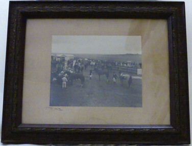
Photograph - Winslow Races 1912, Circa 1912
... Hills” owned by Mr. John O’Keefe about one mile north of the Winslow township.. The annual meetings held on New Year’s Day drew crowds of seven to eight thousand people. This photo provides a snapshot of one of the most important and well patronised events in the district. It is a very clear ...The Winslow races were held from approximately mid-19th century to around 1946. It began as a small picnic race club in Tobin’s paddock to a splendid race course on the property, “Green Hills” owned by Mr. John O’Keefe about one mile north of the Winslow township.. The annual meetings held on New Year’s Day drew crowds of seven to eight thousand people. This photo provides a snapshot of one of the most important and well patronised events in the district. It is a very clear photo, providing evidence of racing operations and fashion of the day. Black and white photograph framed in brown engraved frame with fawn mount. Depicts a gathering of people and horses at race meeting. Winslow New Year’s Day 1912 written in black ink in bottom left corner of mount. Photographer’s name “Jordan Warrnambool,” embossed on bottom right hand corner.winslow, winslow racing club, jordan photographers -
 Warrnambool and District Historical Society Inc.
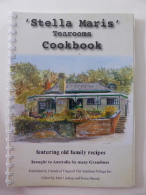
Book, Spectrum Solutions, Stella Maris tearooms Cookbook, 2016
... Hill panorama on the back cover. The book contains an introduction, some information related to food, cooking and diet, recipes from the past and present, some local historical material and some information on the artists whose work is featured in the book. Many colour sketches and photographs are scattered throughout the text. The book is bound with plastic spiral rings and the front is covered with a sheet of clear...Hill panorama on the back cover. The book contains an introduction, some information related to food, cooking and diet, recipes from the past and present, some local historical material and some information on the artists whose work is featured in the book. Many colour sketches and photographs are scattered throughout the text. The book is bound with plastic spiral rings and the front is covered with a sheet of clear ...A cookbook featuring old family recipes.This is a soft cover book of 100 pages. The cover has a white background with a colour sketch of the Flagstaff Hill Maritime Village Stella Maris Tea Rooms on the front cover and a colour photograph of a Flagstaff Hill panorama on the back cover. The book contains an introduction, some information related to food, cooking and diet, recipes from the past and present, some local historical material and some information on the artists whose work is featured in the book. Many colour sketches and photographs are scattered throughout the text. The book is bound with plastic spiral rings and the front is covered with a sheet of clear plastic. non-fictionA cookbook featuring old family recipes.stella maris tea rooms, warrnambool, flagstaff hill maritime village, history of warrnambool, cookbook -
 Kiewa Valley Historical Society
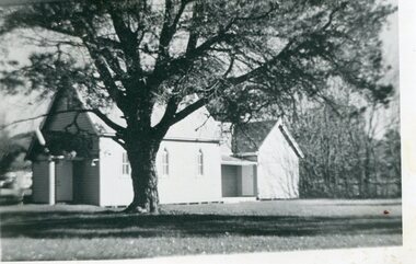
Photographs – Set of 4 black and white photographs. One of a wooden church and three of rural homes and farmland. Area not identified
... cleared of trees (stumps remaining). In the background are larger farming properties with the road disappearing into the distant hills. ...cleared of trees (stumps remaining). In the background are larger farming properties with the road disappearing into the distant hills. ...Europeans arrived in the Kiewa and Ovens Valleys in the 1830's and 40's. Following the drought of 1838-44, seeking out the rich pastures in the fertile Valleys. It proved to be perfect conditions for dairy farming and the raising of cattle. Miners Cottages and other similar wooden structures were a common sight in the area as they were a modest form of accommodation for their period, were quick to erect and economical as they made use of locally available building materials such as local timbers.These photographs provide a snapshot into the early dwellings and architecture of the Kiewa and Ovens Valley regions, including buildings such as the church, which provided an important gathering place for social interaction, especially in these isolated areas.1-Wooden church building with no identification. Large tree in the foreground in front of church 2&3- Black and white photographs of farmland and assorted dwellings, mostly miners style cottages in a valley with mountains in the background. A bridge with wooden railings is visible over the river in the middle of the photograph, also a more modern dwelling is visible in the north east of the photograph close to the river. 4-Black and white photograph of residential homes and farmland with an unsealed road running through the middle. Foreground shows a field which has been semi cleared of trees (stumps remaining). In the background are larger farming properties with the road disappearing into the distant hills. This might be Old Tallangatta before the town was moved in 1956. 1-3 - No inscriptions 4- Signature written on back in lead pencil - Sandra Templebuildings; church; farmland -
 Kiewa Valley Historical Society
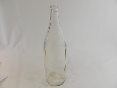
Bottle - Soft Drink, 1940s - 1950s
... Bendigo & Swan Hill. At the base - F1449 AGM (crown seal) M 2 Clear glass bottle. ...Soft drink came in bottles bought at the local grocery store or at a large city store on a shopping expedition. The shape of the bottles changed as did the stopper used to seal it. Bottles were re-cycled remaining the property of the manufacturer. History of Cohn Bros., Bendigo & Swan Hill.Historical: Change of bottles - shape, glass, stopper, embossing, use. Aesthetic: Display showing embossing & shape especially if in good condition.Clear glass bottle. Bottom half has straight sides. The top half tapers to the top where a metal crimp fits over the lip. Manufacturer's name is embossed in print in block letters with its logo just above halfway from the bottom. At the base on the sides is embossing in capital letters around the circumference. The base is embossed with the crown seal of AGM.On 1 side half way up is embossed - Cohn / circle with CB inside around top of circle is Bendigo and around bottom of the circle is Swan Hill / Bros.is on the other side of the circle. - On the other side is embossed - The property of the Cohn Bros. Vic. Bry. Co. Ltd. Bendigo & Swan Hill. At the base - F1449 AGM (crown seal) M 2glass, bottle, domestic, household, drinks, lemonade, cohn bros., swan hill, bendigo -
 Kiewa Valley Historical Society
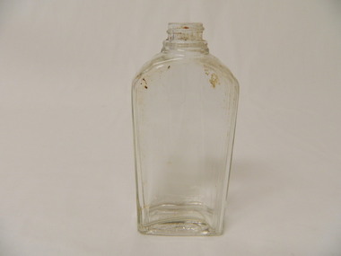
Bottle - Chemist, 1920's
... Clear glass bottle with rectangular base and straight sides nearly three quarters of the way up tapering in 3 waves to a ridged neck and then a screw top. Visually but inside the glass at the base seems to be indented showing a lopsided hill bearing to one side....Historical: Change of bottles - shape, glass, stopper, embossing, use Aesthetic: Display showing shape and size of bottle chemist perfume lavendar water bath salts glass bottle Base: '12' within an oval shape Clear glass bottle with rectangular base and straight sides nearly three quarters of the way up tapering in 3 waves to a ridged neck and then a screw top. Visually but inside the glass at the base seems to be indented showing a lopsided hill bearing to one side. ...Perfume, lavender water and bath salts were sold by chemists either locally of in larger cities visited on a shopping expedition. The shape of the bottles changed as did the stopper used to seal it.Historical: Change of bottles - shape, glass, stopper, embossing, use Aesthetic: Display showing shape and size of bottleClear glass bottle with rectangular base and straight sides nearly three quarters of the way up tapering in 3 waves to a ridged neck and then a screw top. Visually but inside the glass at the base seems to be indented showing a lopsided hill bearing to one side.Base: '12' within an oval shape chemist, perfume, lavendar water, bath salts, glass bottle -
 Bendigo Military Museum
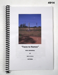
Booklet, Produced by Mologa and District Landcare Group in/ conjunction with friends and residents of Mologa" Ref: " Pyramid Hill Historical Society", "Faces to Names", 2015
... clear plastic, spiral bound with hard plastic spiral in black. Title cover - paper, black print on front, illustrated with colour photographs of a Soldiers Memorial. No page numbers printed. Paper, cut, plain, white. Illustrated black and white and colour photographs, portraits and newspaper articles. "Faces to Names" Booklet BOOKLET Produced by Mologa and District Landcare Group in/ conjunction with friends and residents of Mologa" Ref: " Pyramid Hill ..."FACES TO NAMES" , WW1 MEMORIAL AT MOLOGA, VICTORIA".Soft cover booklet. Soft cover - clear plastic, spiral bound with hard plastic spiral in black. Title cover - paper, black print on front, illustrated with colour photographs of a Soldiers Memorial. No page numbers printed. Paper, cut, plain, white. Illustrated black and white and colour photographs, portraits and newspaper articles.booklet, biography, soldiers memorial, ww1 -
 Kiewa Valley Historical Society
Photograph of Kiewa Valley Panorama, Kiewa Valley from No. 5 Road, Before 1945
... Hill Scenic Lookout. Is an excellent view of the Kiewa Valley before there was little work undertaken to establish the town of Mt. Beauty. Farming was well established with the evidence of huge areas of cleared land. ...In 1943 a camp for workmen was erected and a commencement made with the erection of plant storage and workshop buildings in the new township of Mt. Beauty. The photograph was probably taken after the completion of these buildings. There is no sign of construction of the town itself. In the latter part of 1945 work was commenced on the Mt. Beauty township area with a medical centre, general trading store and some houses under construction. The No. 5 Road, from where the photograph was taken, is the road to West Kiewa Power Station and Big Hill Scenic Lookout.Is an excellent view of the Kiewa Valley before there was little work undertaken to establish the town of Mt. Beauty. Farming was well established with the evidence of huge areas of cleared land. The junction of the East and West Kiewa Rivers can be clearly seen. The first Workmen's camp is near the river and some workshop buildings can also be seen. Black and white photograph of the Kiewa Valley, looking North.Handwritten on the back of photograph "Kiewa Valley from No. 5 Road".kiewa valley, camp, buildings, mt. beauty -
 Bendigo Military Museum
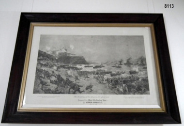
Print - PRINT, FRAMED, "The Landing of the ANZAC's 25 April 1915"
... It is not clear when this item came to the SMI but it was many years prior to SMI becoming a museum. brsl smirsl Below print/painting - Block printing - title of painting " THE LANDING OF THE ANZACs 25 April 1915 , Presented to White Hills Reading Room by Vernon Rymer ESQ" Very large framed black and white print of a painting of " The Landing of the Anzacs, 25th April, 1915" from original by Charles Dixon R.I 1915. ...This item was originally hanging over the double doors inside the Billiard Room of the Soldiers Memorial Institute pre being a Museum in 1998. After the renovations to the SMI 2016 - 18 it was placed on the other side of the double doors in the foyer. It is not clear when this item came to the SMI but it was many years prior to SMI becoming a museum.Very large framed black and white print of a painting of " The Landing of the Anzacs, 25th April, 1915" from original by Charles Dixon R.I 1915. Title - Presented to White Hills Reading Room by Vernon Rymer ESQ, November 14th, 1921. Frame - heavy timber, dark brown stain with gold painted inner edge, glass front. Mount - Off white cardboardBelow print/painting - Block printing - title of painting " THE LANDING OF THE ANZACs 25 April 1915 , Presented to White Hills Reading Room by Vernon Rymer ESQ" brsl, smirsl -
 Kiewa Valley Historical Society
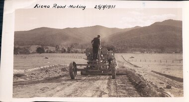
Black and White photograph of Road Making Machinery, Kiewa Road Making 25/08/1938 No. 2, 25/08/1938
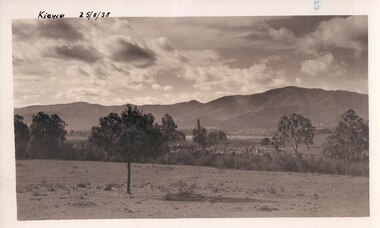
... Mount Beauty hills can be seen in the background with cleared land for grazing in the fore ground....Mount Beauty hills can be seen in the background with cleared land for grazing in the fore ground. ...Construction of the main road from South Tawonga to the Bogong High Plains, to provide access to the construction sites for the new Kiewa Hydro Electric Scheme, was commenced early in 1938, the work being undertaken on behalf of the commission by the Country Roads Board. For the construction work, the Commission purchased three Caterpillar - model R07 - diesel crawler tractors equipped with Kay Brunerei (Brunner) hydraulically operated trailbuilders (angle dozers). This acquisition resulted from a visit to the United States of America in May, 1937 by the Construction Engineer ( Mr. C.H. Kernot) and Assistant Civil Engineer ( Mr. J.F. Douglas) where they saw this relatively new type of equipment in use. With the co-operation of the CRB, the Commission demonstrated the operation of these machines at Fishermen's Bend on 6th April, 1938. They were then sent to Kiewa where they commenced operation towards the end of the month. From South Tawonga, the route let immediately across the Western Branch of the Kiewa River necessitating the construction of a bridge 100 feet long. By the end of 1939, the excavation had been 'opened up' for a distance of 19 1/2 miles (approx. 31 km.) and of this length, 10 miles (approx. 16 km.) had been surfaced. (see KVHS 0328)The purchase of this type of mechanical equipment in road making was a huge investment, as prior to this most of the work would have been done manually with the use of picks and shovels. Not only were many months of hard manual labour saved, but a very significant amount of time in providing access to the proposed work sites for the new Kiewa Hydro Scheme. This photo is an excellent reminder of how primitive the early machinery was compared to the present but also represents the forward thinking of the State Electricity Commissions engineers in purchasing such innovative equipment.A black and white photograph of road making near Mt. Beauty in 1938. Mount Beauty hills can be seen in the background with cleared land for grazing in the fore ground.Hand printed in black ink at the top of the photograph is 'Kiewa Road Making 25/8/1938'. On the right hand corner has been printed the number 2. It has been printed on gloss Velox paper.road making, state electricity commission, caterpillar tractor, kiewa, secv -
 Kiewa Valley Historical Society
Black and white photograph of farmland, Kiewa, 25/8/38, circa 1938
... cleared of natural growth and has been used for grazing cattle. By 1946 housing construction had commenced for the new town of Mt. Beauty and by 1948 street construction in the southern part of the town was completed as far as Hill Street. road construction kiewa tawonga mt. beauty secv Handwritten in black ink on the upper left corner of the photograph is the inscription 'Kiewa 25/8/38' and the number 5 has been stamped on the upper right hand corner. ...This photograph was taken in August, 1938 some eight years prior to the establishment of Mt. Beauty as a township. The area was still being used for grazing, and the land was eventually acquired from the local land owners by the State Electricity Commission. The construction of the road, from Tawonga to the High Plains, was commenced in April of this year. This allowed men and heavy equipment to be transported to the work sites for the construction of the Kiewa Hydro Electric Scheme This photograph is important as it shows the upper Kiewa Valley as it was before the establishment of the town of Mt. Beauty. The land has been cleared of natural growth and has been used for grazing cattle. By 1946 housing construction had commenced for the new town of Mt. Beauty and by 1948 street construction in the southern part of the town was completed as far as Hill Street.A black and white photograph of farmland with Mt. Emu in the background. This has been taken from where Mt. Beauty township now stands prior to road making and the erection of houses. A line of trees below the hill line indicates the position of the East Kiewa River. (No. 5 in a set of 8) Handwritten in black ink on the upper left corner of the photograph is the inscription 'Kiewa 25/8/38' and the number 5 has been stamped on the upper right hand corner. On the back is the word 'Velox' which is the name of the photographic paper on which the photo was developed.road construction, kiewa, tawonga, mt. beauty, secv -
 Kiewa Valley Historical Society
Black and white photograph of farmland, Kiewa, 25/8/38, circa 1938
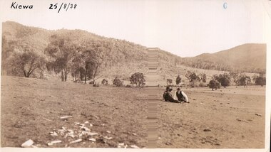
... cleared of natural growth and has been used for grazing cattle. By 1946 housing construction had commenced for the new town of Mt. Beauty and by 1948 street construction in the southern part of the town was completed as far as Hill Street. kiewa mt. beauty construction grazing secv Handwritten in black ink is the inscription 'Kiewa 25/8/1938'. ...This photograph was taken in August, 1938 at the time of road making in the area and some eight years prior to the establishment of Mt. Beauty township. The area was still being used for grazing, and the land was eventually acquired from the local land owners by the State Electricity Commission. The construction of the road, from Tawonga to the High Plains, was commenced in April of this year. This allowed men and heavy equipment to be transported to the work sites for the construction of the Kiewa Hydro Electric Scheme. An important photograph as it shows the upper Kiewa Valley as it was before the establishment of the town of Mt. Beauty. The land had been cleared of natural growth and has been used for grazing cattle. By 1946 housing construction had commenced for the new town of Mt. Beauty and by 1948 street construction in the southern part of the town was completed as far as Hill Street.A black and white photograph taken in the upper Kiewa Valley showing farmland with a group of three unidentified people sitting on the grass.Handwritten in black ink is the inscription 'Kiewa 25/8/1938'. In the right corner of the photograph has been stamped the number 6. On the back in a circle, some 14mm across, are the words 'Kodak Print'. The word Velox is also printed on the back.kiewa, mt. beauty, construction, grazing, secv -
 Kiewa Valley Historical Society
Black and white photograph of farmland, Kiewa, 25/8/38, circa 1938
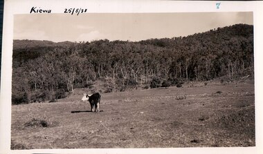
... Hill Street. This photograph is important as it shows the upper Kiewa Valley as it was before the establishment of the town of Mt. Beauty. The land has been cleared ...This photograph was taken in August, 1938, some eight years prior to the establishment of Mt. Beauty a a township. The area was still being used for grazing, and the land was eventually acquired from the local land owners by the State Electricity Commission. The construction of the road, from Tawonga to the High Plains, was commenced in April, 1938 and this photograph was taken August, 1938. This allowed men and heavy equipment to be transported to the work sites for the construction of the Kiewa Hydro Electric Scheme. Prior to this access was by bridle trail, either on horse back or on foot. By 1946 housing construction had commenced for the new town of Mt. Beauty and by 1948 street construction in the southern part of the town was completed as far as Hill Street.This photograph is important as it shows the upper Kiewa Valley as it was before the establishment of the town of Mt. Beauty. The land has been cleared of natural vegetation to allow grazing of cattle. Black and white photograph of grazing farmland with one animal standing in the paddock. The area could possibly be where the golf course now stands with the road to the high plains not yet commenced.Handwritten in the upper left hand corner 'Kiewa 25/8/38'. The number 7 has been stamped in the upper right hand corner. It is part of a set of 8 photographs. On the back are the words Velox repeated several times, indicating the type of photographic papergrazing, kiewa, mt. beauty, secv -
 Kiewa Valley Historical Society
Photograph Farm Land, Kiewa, 25/8/38, circa 1938
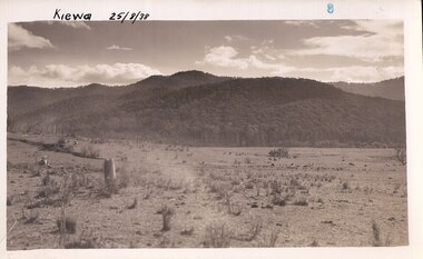
... Hill Street. This is an important photograph as it shows the upper Kiewa Valley and the site for Mt. Beauty as it was before the establishment of the town. The land has been cleared ...This photograph was taken in august, 1938 some eight years prior to the establishment of Mt. Beauty as a township. The area was still being used for grazing cattle and the land was eventually acquired from the local land owners by the State Electricity Commission. The construction of the road, from Tawonga to the High Plains, was commenced in April of 1938. This allowed men and heavy equipment to be transported to the work sites for the construction of the Kiewa Hydro Electric Scheme. Prior to this access was by bridle trail, either on horse back or by foot. By 1946 housing construction had commenced for the new town of Mt. Beauty and by 1948 street construction in the southern part of the town was completed as far as Hill Street.This is an important photograph as it shows the upper Kiewa Valley and the site for Mt. Beauty as it was before the establishment of the town. The land has been cleared of natural vegetation and used for grazing cattle.Black and white photograph of farmland, cattle in the distance, hills in the backgroundHandwritten in the upper left hand corner, in black ink, 'Kiewa 25/8/38'. The number 8 has been stamped in the upper right hand side of the photograph. On the back have been stamped the words Velox, indicating the type of photographic paper.kiewa, mt. beauty, construction, grazing, secv -
 Federation University Historical Collection
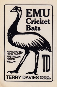
Article - Article - Advertising sticker, ZILLES COLLECTION: Sticker advertising Emu Cricket Bats by Terry Davies, Ballarat
... Terry was named in the Northern Roosters Cricket Club Legends Team of the Century 1920-2000. zilles printers ballarat sir rowland hill adhesive paper santo avery avery labels self-adhesive label terry davies batsman melbourne country week northern roosters cricket club legends team of the century 1920-2000 Name of bat and name of maker TD. - Emu Cricket Bats, handcrafted from finest Australian Fisher Willow. Terry Davies, Ballarat Victoria. Cream colour card backing a clear ...Zilles Printers was begun by Lewis Zilles in the early 1930s. It was in McKenzie Street Ballarat. His son Jeffrey also became a printer - letterpress, offset and screen printer. The business became Zilles Printers/Graphics and was in Armstrong Street and later Bell Street Ballarat. A form of sticker began in 1839 when Sir Rowland Hill invented adhesive paper. The first self-adhesive label was invented in 1935 by Stanton Avery - Avery Labels. The sticker was used on the bats as advertisement. Terry Davies was one of the top batsmen in Ballarat during the 1970s. He played from 1971-71 to 1982-83, a total of 151 games. He captained Ballarat in Melbourne Country Week as well as being Captain-Coach of the club. Terry was named in the Northern Roosters Cricket Club Legends Team of the Century 1920-2000.Cream colour card backing a clear sticker with black print.Name of bat and name of maker TD. - Emu Cricket Bats, handcrafted from finest Australian Fisher Willow. Terry Davies, Ballarat Victoria.zilles printers, ballarat, sir rowland hill, adhesive paper, santo avery, avery labels, self-adhesive label, terry davies, batsman, melbourne country week, northern roosters cricket club, legends team of the century 1920-2000 -
 Orbost & District Historical Society
poison pot, Smith, R. & E, 1940's
... This enabled the hill country at Bete Bolong to become more productive. The dead trees and shrubs were later cleared by Erle Broome's D7 caterpillar bulldozer. ...This enabled the hill country at Bete Bolong to become more productive. The dead trees and shrubs were later cleared by Erle Broome's D7 caterpillar bulldozer. ...This item was used on P.C. Toby Nixon and Grace Nixon's farm, "Rolling Downs" at Bete Bolong. During WW11 the farm grew carrots, red beet, cabbages, beans and maize. Because of labour shortages the government built a Prisoner of War Camp on Russell's Hill. The manager, Dick Northrope, used three Italian prisoners to frill ring small trees and shrubs between crop harvesting. The introduction of ‘frill ringing’ and poisoning with arsenical tree killers in the 1940's and 1950's helped reduce the amount of labour required and trees on more country were treated. This enabled the hill country at Bete Bolong to become more productive. The dead trees and shrubs were later cleared by Erle Broome's D7 caterpillar bulldozer. This was the first big area of 230 acres to be cleared in the Orbost district. Soon after entering World War 11 Australia was asked by Britain to accept and guard large numbers of 'enemy aliens' and prisoners of war. The British government felt that it could not afford to feed large numbers of prisoners and it was believed that once in Australia the internees would have no chance of escape. Eager to show solidarity with Britain's cause, Australia readily agreed and decided to place the prisoners in a number of different camps scattered around the country and guard them with reservists and soldiers too unfit to serve overseas. There was an internment camp at Bete Bolong, Orbost. This item is an example of an item used by the Italian P.O.W.'s residing there. It is also an example of an agricultural tool not commonly used today.A galvanized iron watering can which has been used to hold poison for ring barking trees (possibly arsenic). It has a narrow spout. There is a handle at the back and a folding handle on the top. The top is conical with an opening for a cork. agriculture prisoner-of-war-camp tree-removal land-clearing