Showing 1906 items matching "counties"
-
 Emerald Museum & Nobelius Heritage Park
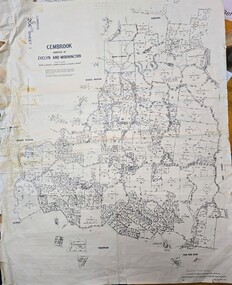
Map - Land Holding map issued by Lands Council Victoria - area south of Emerald township (now mostly under Cardinia Reservoir), Gembrook, Counties of Evelyn & Mornington land holding map 1967, c1967
... Gembrook, Counties of Evelyn & Mornington land holding map 1967...Image of land holdings map for area south of Emerald township in the counties of Evelyn & Mornington, Gembrook...Gembrook G206 Sheet/Gembrook counties of Evelyn and Mornington/Compared with originals H.R. ...JOHNSON (22.8.68)/By Authority AC Brooks, Government Printer, Melbourne/Drawn and reproduced at the Department of Lands and Survey, Melbourne/Price $1.00 per sheet Image of land holdings map for area south of Emerald township in the counties of Evelyn & Mornington, Gembrook Gembrook, Counties of Evelyn & Mornington land holding map 1967 Map Land Holding map issued by Lands Council Victoria - area south of Emerald township (now mostly under Cardinia Reservoir) ...land holdings map showing holdings south of the main township of Emerald, much or which is now under the Cardinia ReservoirImage of land holdings map for area south of Emerald township in the counties of Evelyn & Mornington, GembrookGembrook G206 Sheet/Gembrook counties of Evelyn and Mornington/Compared with originals H.R. JOHNSON (22.8.68)/By Authority AC Brooks, Government Printer, Melbourne/Drawn and reproduced at the Department of Lands and Survey, Melbourne/Price $1.00 per sheet -
 Stawell Historical Society Inc
Map, Bulgana, Counties of Borung & Ripon, 1959
... Bulgana, Counties of Borung & Ripon...Bulgana, Counties of Borung & Ripon...Stawell Historical Society Inc 46 Longfield St Stawell grampians Stawell Bulgana, Counties of Borung & Ripon Bulgana, Counties of Borung & Ripon Map ...Bulgana, Counties of Borung & Riponstawell -
Stawell Historical Society Inc
Map, Callawadda, Counties of Borung & Kara Kara, 1959
... Callawadda, Counties of Borung & Kara Kara...Callawadda, Counties of Borung & Kara Kara...Stawell Historical Society Inc 46 Longfield St Stawell grampians Stawell Callawadda, Counties of Borung & Kara Kara Callawadda, Counties of Borung & Kara Kara Map ...Callawadda, Counties of Borung & Kara Karastawell -
Stawell Historical Society Inc
Map, Physical description Concongella South, Counties of Borung & Ripon, 1957
... Physical description Concongella South, Counties of Borung & Ripon...Concongella South, Counties of Borung & Ripon...Stawell Historical Society Inc 46 Longfield St Stawell grampians Stawell Concongella South, Counties of Borung & Ripon Physical description Concongella South, Counties of Borung & Ripon Map ...Concongella South, Counties of Borung & Riponstawell -
Stawell Historical Society Inc
Map, Glynwylln, Counties of Borung & Kara Kara, 1929
... Glynwylln, Counties of Borung & Kara Kara...Glynwylln, Counties of Borung & Kara Kara...Stawell Historical Society Inc 46 Longfield St Stawell grampians Stawell Glynwylln, Counties of Borung & Kara Kara Glynwylln, Counties of Borung & Kara Kara Map ...Glynwylln, Counties of Borung & Kara Karastawell -
Stawell Historical Society Inc
Map, Crowlands, Counties of Borung & Kara Kara, 1954
... Crowlands, Counties of Borung & Kara Kara ...Crowlands, Counties of Borung & Kara Kara...Stawell Historical Society Inc 46 Longfield St Stawell grampians Stawell Crowlands, Counties of Borung & Kara Kara Crowlands, Counties of Borung & Kara Kara Map ...Crowlands, Counties of Borung & Kara Karastawell -
 Federation University Historical Collection
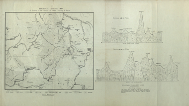
Map, Geological Sketch Map of of Dundas, Berung, and Ripon Counties
... Geological Sketch Map of of Dundas, Berung, and Ripon Counties...Map of the Counties of Dundas, Berung, and Ripon...county of dundas county of berung county of ripon map geology ararat stawell hamilton grampians Map of the Counties of Dundas, Berung, and Ripon Geological Sketch Map of of Dundas, Berung, and Ripon Counties Map Map ...Map of the Counties of Dundas, Berung, and Riponcounty of dundas, county of berung, county of ripon, map, geology, ararat, stawell, hamilton, grampians -
Stawell Historical Society Inc
Map, Joel Joel, Counties of Kara Kara & Borung, 1946
... Joel Joel, Counties of Kara Kara & Borung...Joel Joel, Counties of Kara Kara & Borung...Stawell Historical Society Inc 46 Longfield St Stawell grampians Stawell Joel Joel, Counties of Kara Kara & Borung Joel Joel, Counties of Kara Kara & Borung Map ...Joel Joel, Counties of Kara Kara & Borungstawell -
 Flagstaff Hill Maritime Museum and Village
Book - Atlas, F.E. Hiscocks and Co, New Victorian Counties Atlas, 1874
... New Victorian Counties Atlas...The New Victorian Counties Atlas is highly prized by historians and map collectors today because it represents the pinnacle of colonial commercial printing. ...Hard cover book, New Victorian Counties Atlas Author: F.E. Hiscocks and Co, Publisher: George Robertson, Melbourne Vic. ...The New Victorian Counties Atlas is highly prized by historians and map collectors today because it represents the pinnacle of colonial commercial printing. ...Published in Melbourne in 1874 by the prominent bookseller and publisher George Robertson, F.E. Hiscocks & Co.’s New Victorian Counties Atlas is a monumental 19th-century cartographic and statistical record of the colony of Victoria. While George Robertson was the publisher responsible for production, marketing, and distribution, the detailed compiling and surveying were executed by F.E. Hiscocks & Co., with the striking colour lithography handled by the renowned Melbourne firm Hamel & Ferguson.Hard cover book, New Victorian Counties Atlas Author: F.E. Hiscocks and Co, Publisher: George Robertson, Melbourne Vic. Date: 1874 Morocco Olive hardcover with a damaged black spine, reinforced corners to hardcover gold edging to where spine meets hardcover. Title in a lozenge on front cover edged with a decorative panel. non-fictionPublished in Melbourne in 1874 by the prominent bookseller and publisher George Robertson, F.E. Hiscocks & Co.’s New Victorian Counties Atlas is a monumental 19th-century cartographic and statistical record of the colony of Victoria. While George Robertson was the publisher responsible for production, marketing, and distribution, the detailed compiling and surveying were executed by F.E. Hiscocks & Co., with the striking colour lithography handled by the renowned Melbourne firm Hamel & Ferguson.flagstaff hill, warrnambool, maritime village, maritime museum, shipwreck coast, great ocean road, new victorian counties atlas, hiscocks and co, atlas, maps -
Federation University Historical Collection
Document, Crown Lands in Villiers and Westward Counties, 1856-7, 1856-7
... Crown Lands in Villiers and Westward Counties, 1856-7...Blue foolscap printed Government document lon Crown lands in Villiers and Westward Counties. It inlcudes the return shoiung number of acres of land sold and the amount received for same. ...Crown Lands in Villiers and Westward Counties, 1856-7 Document John Ferres John Ferres ...Blue foolscap printed Government document lon Crown lands in Villiers and Westward Counties. It inlcudes the return shoiung number of acres of land sold and the amount received for same. land, land sales, villiers, heytesbury, hampden, normanby, dundas, follett, crown lands -
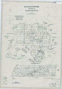
 Greensborough Historical Society
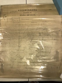
Map, Victoria. Department of Crown Lands and Survey, Keelbundoora; Counties of Bourke and Evelyn, 1950c
... Keelbundoora; Counties of Bourke and Evelyn...Map of the Victorian counties of Bourke and Evelyn showing parish boundaries and land ownership....Greensborough Historical Society 34A Glenauburn Road Lower Plenty Lower Plenty melbourne Map of the Victorian counties of Bourke and Evelyn showing parish boundaries and land ownership. ...Map of the Victorian counties of Bourke and Evelyn showing parish boundaries and land ownership.Show the original landholders for this area.Map on light brown parchment, covered in plastic."L.5305" and "3462" -
 Ballan Shire Historical Society
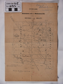
Map - Map. Moorarbool East and West, Country Lands in the Parishes of Moorarbool East and Moorarbool West. Counties of Bourke and Grant
... Country Lands in the Parishes of Moorarbool East and Moorarbool West. Counties of Bourke and Grant....This is a map of "Country Lands" around the Werribee River, north of Ballan in the Counties of Bourke and Grant....Ballan Shire Historical Society 45-47 Steiglitz St Ballan goldfields This is a map of "Country Lands" around the Werribee River, north of Ballan in the Counties of Bourke and Grant. moorarbool west moorarbool east dugald mcpherson County of Bourke County of Grant Werribee River Ballan There is a small inscription under the chain scale that reads "No 58/364 John Phillips ? ...This is a map of "Country Lands" around the Werribee River, north of Ballan in the Counties of Bourke and Grant.A relatively small map, paper on a material backing. Shows topographical features, roads and property divisions. Scale of forty chains to one inch. The map is dated March 31st, 1859.There is a small inscription under the chain scale that reads "No 58/364 John Phillips ? Survey 1st August 1858". The name Dugald McPherson is hand written on one of the blocks of land.moorarbool west, moorarbool east, dugald mcpherson, county of bourke, county of grant, werribee river, ballan -
National Wool Museum
Book, Reconnaissance survey of the sheep industry, No.8: the counties of Tatchera and Gunbower, Victoria, 1952
... Reconnaissance survey of the sheep industry, No.8: the counties of Tatchera and Gunbower, Victoria, 1952..."Reconnaissance survey of the sheep industry, No.8: the counties of Tatchera and Gunbower, Victoria, 1952" Bureau of Agricultural Economics...National Wool Museum 26 Moorabool Street Geelong geelong-and-the-bellarine-peninsula "Reconnaissance survey of the sheep industry, No.8: the counties of Tatchera and Gunbower, Victoria, 1952" Bureau of Agricultural Economics Agriculture Wool Growing C. of A. - Bureau of Agricultural Economics Agriculture Wool Growing Reconnaissance survey of the sheep industry, No.8: the counties of Tatchera and Gunbower, Victoria, 1952 Book ..."Reconnaissance survey of the sheep industry, No.8: the counties of Tatchera and Gunbower, Victoria, 1952" Bureau of Agricultural Economicsagriculture wool growing, c. of a. - bureau of agricultural economics, agriculture, wool growing -
National Wool Museum
Book, Reconnaissance studies of the sheep industry: the counties of Bogong and Benambra, Victoria, 1950
... Reconnaissance studies of the sheep industry: the counties of Bogong and Benambra, Victoria, 1950..."Reconnaissance studies of the sheep industry: the counties of Bogong and Benambra, Victoria, 1950" - Bureau of Agricultural Economics, Canberra...National Wool Museum 26 Moorabool Street Geelong geelong-and-the-bellarine-peninsula "Reconnaissance studies of the sheep industry: the counties of Bogong and Benambra, Victoria, 1950" - Bureau of Agricultural Economics, Canberra Agriculture Wool Growing C. of A. - Bureau of Agricultural Economics Agriculture Wool Growing Reconnaissance studies of the sheep industry: the counties of Bogong and Benambra, Victoria, 1950 Book ..."Reconnaissance studies of the sheep industry: the counties of Bogong and Benambra, Victoria, 1950" - Bureau of Agricultural Economics, Canberraagriculture wool growing, c. of a. - bureau of agricultural economics, agriculture, wool growing -
 Federation University Historical Collection
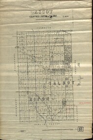
Plan - map, Ascot: Counties of Ripon and Talbot, 18/12/1920
... Ascot: Counties of Ripon and Talbot......counties...Photo-Lithographed at the Dept. of Lands and Survey. Ascot: Counties of Ripon and Talbot Plan map W.J.Butson ...Cadastral map showing parish boundaries and land ownership. "L5270"Maps parishes located in Ascot area. Photo-Lithographed at the Dept. of Lands and Survey.Highlighted parish labelled, Mrs E.C.Sutherland.parish, map, ascot, counties, e. c. sutherland, a. cameron, sweeney, w. j. clarke, mount hollowback, tourello, burrumbeet, glendaruel, dowling forest, a. j. mullett, w. j. butson, 1920, william coghill, chatham, chatham family collection, mrs e.c.sutherland. -
Phillip Island and District Historical Society Inc.
Book, F.E. Hiscocks &? Co, F.E. Hiscocks &? Co.'s new Victorian counties atlas, 1874 [cartographic material] : together with map of Victoria, indicating roads, distances, relative position of counties, &?c, 1874
... s new Victorian counties atlas, 1874 [cartographic material] : together with map of Victoria, indicating roads, distances, relative position of counties, &?...s new Victorian counties atlas, 1874 [cartographic material] : together with map of Victoria, indicating roads, distances, relative position of counties, &? ...Labelled 'Cowes Free Public Library', 'Phillip Island Historical Society, Cleeland Bequest'.victoria, maps -
Moorabbin Air Museum
Book - METEOR, STEVEN J. BOND, 1985
... ...MIDLAND COUNTIES PUBLICATIONS (AEROPHILE) LTD...Moorabbin Air Museum Moorabbin Airport 12 First Street Moorabbin melbourne METEOR Book METEOR STEVEN J. BOND MIDLAND COUNTIES PUBLICATIONS (AEROPHILE) LTD ... -
 Sunshine and District Historical Society Incorporated
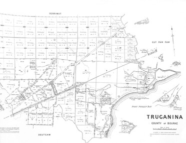
Map - Truganina County of Bourke 1959 Map, Department of Lands and Survey Malbourne, 1959
... Map Truganina County of Bourke 1959 Map...Truganina County of Bourke 1959 Map...Truganina Map Truganina County of Bourke 1959 Map Map Truganina County of Bourke 1959 Map Map Truganina County of Bourke 1959 Map Department of Lands and Survey Malbourne ...Truganina County of Bourke 1959 Maptruganina, map -
 Ballan Shire Historical Society
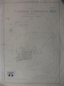
Map - Map. Ballan Township, Plan of Ballan Township in the Counties of Bourke and Grant
... Plan of Ballan Township in the Counties of Bourke and Grant....Plan of Ballan Township in the Counties of Bourke and Grant. Map Map. Ballan Township. ...The map is an early one of the township of Ballan showing street names and land owners.The map is significant in that it lists the owners of the house blocks within the township.A map showing the township and surrounding area of Ballan in 1856. Town streets are named as are the owners of the subdivided blocks of land. The map is a lithocopy and there is a scale in chains."D D Fraser" is written across the top of the map and "1856" is written in the near top right corner. There are other additions to the map but they are very difficult to decipher accurately or completely.ballan, ballan township map, ballan1856 -
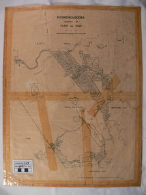 Ballan Shire Historical Society
Map - Map. Korweinguboora, Department of Lands and Survey, Korweinguboora. Counties of Talbot and Grant
... Korweinguboora. Counties of Talbot and Grant....Korweinguboora. Counties of Talbot and Grant. Map Map. Korweinguboora. ...A map of the Korweinguboora area showing roads, forests, railway lines and properties with the owners names.The inclusion of the names of landowners is of significance and value to historians.A map of the Korweinguboora area showing land subdivisions and names of owners and other physical features. There is a scale in chains. No date is certain but it could be 1902. The map has been repaired with sellotape.There are various pencil annotations but the are difficult to read.talbot, moorarbool west, wombat, bullarto, korweinguboora, moorarbool east, dean, wombat state forest, barkstead -
 Greensborough Historical Society
Map, Keelbundora. Counties of Bourke and Evelyn, 1950_11
... Keelbundora. Counties of Bourke and Evelyn...Greensborough Historical Society 34A Glenauburn Road Lower Plenty Lower Plenty melbourne Covers area bounded by Merri Creek, Yarra River, Plenty River and Crown Portions 24 to 28, with section including Maroondah Aqueduct and Darebin Creek. keelbundora (parish) Photocopy of digitised map Keelbundora. Counties of Bourke and Evelyn Map Victoria. Department of Lands and Survey ...Covers area bounded by Merri Creek, Yarra River, Plenty River and Crown Portions 24 to 28, with section including Maroondah Aqueduct and Darebin Creek.Photocopy of digitised mapkeelbundora (parish) -
Phillip Island and District Historical Society Inc.
Book, FITTER, R.S.R, Home counties / R.S.R. Fitter, 1951
... Home counties / R.S.R. Fitter...Inscribed 'I love the way Australians refer to England as Home. Kit.... ' Home counties / R.S.R. Fitter Book FITTER, R.S.R. ...Labelled 'Himmer Bequest'. Stamped 'Cowes Public Library'. Inscribed 'I love the way Australians refer to England as Home. Kit.... ' -
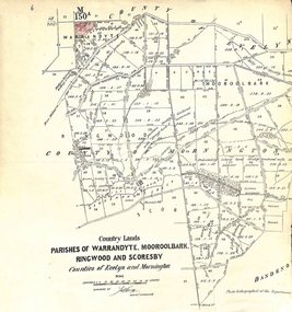 Ringwood and District Historical Society
Map - Plan of Survey, Country Lands, Parishes of Warrandyte, Mooroolbark, Ringwood and Scoresby, Counties of Evelyn and Mornington - circa 1855
... Country Lands, Parishes of Warrandyte, Mooroolbark, Ringwood and Scoresby, Counties of Evelyn and Mornington - circa 1855....Country Lands, Parishes of Warrandyte, Mooroolbark, Ringwood and Scoresby, Counties of Evelyn and Mornington - circa 1855. ...Clipped section of larger survey map including descriptions of treed areas and topographical features. Surveyed by (signature of J. Hardy) - Assistant Surveyor. -
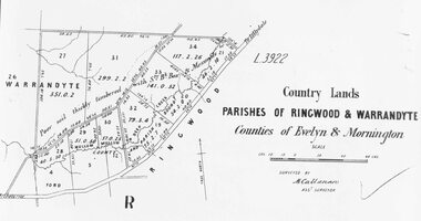
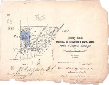 Ringwood and District Historical Society
Map, Country Lands, Parishes of Ringwood & Warrandyte, Counties of Evelyn and Mornington - 1868
... Country Lands, Parishes of Ringwood & Warrandyte, Counties of Evelyn and Mornington - 1868....Country Lands, Parishes of Ringwood & Warrandyte, Counties of Evelyn and Mornington - 1868. Map ...Blue shaded area marked on Department of Lands & Survey map highlighting portion of allotment 27B applied for by James Forbes. Torn edges.L3922. Photo-lighographed at DL&S, Melbourne by J. Noone, June 8th, 1868. Signature of Assistant Surveyor M. Callanan dated 26.7.1875. Noted on R72 by H. Robinson, 1.10.1875. -
 Ringwood and District Historical Society
Map, Early map of Parishes of Ringwood and Warrandyte in Counties of Evelyn and Mornington - c.1868, 1868
... Early map of Parishes of Ringwood and Warrandyte in Counties of Evelyn and Mornington - c.1868...Early map of Parishes of Ringwood and Warrandyte in Counties of Evelyn and Mornington - c.1868 Map ...Black and white hand drawn map of Ringwood and Warrandyte areas.Map surveyed by M. Callanan, Assistant Surveyor. Written on rear of backing sheet: "c1868. Vol. 5, Fol.13/1224." (From Parish Map collection) -
 City of Moorabbin Historical Society (Operating the Box Cottage Museum)
Document, laminated photocopy of 'Plan of Moorabbin 1850', 1853
... A photocopy of a Map of the Moorabbin , County of Bourke c1850. A3 size laminated...Left corner : MOORABBIN / COUNTY OF / BOURKE...Land Sales proceeded from 1844 as more immigrants established market gardens, farms and varied businesses in 'Moorabbin' This is a photocopy of a Map of the Moorabbin , County of Bourke c1850 showing the 'Henry Dendy Special Survey 1841' dendy henry dendy special survey 1841 brighton moorabbin ormond bentleigh market gardeners pioneers early settlers box william box elizabeth Left corner : MOORABBIN / COUNTY OF / BOURKE A photocopy of a Map of the Moorabbin , County of Bourke c1850. ...Weston Bate, 'A history of Brighton' 1962 informs us that in 1840 Henry Dendy, who was a farmer in Sussex England, paid 5,120 pounds sterling @ 1pound per acre for a 'Special Survey of Land in Port Phillip , Australia. Henry arrived in Australia in 1841 on the frigate 'York' with his wife, son, and three servants. He also took advantage of the Government Assistance of Free Immigrants for Survey Purchasers, to help on his estate and persuaded some Sussex men with their families to follow him. However when Dendy arrived in Port Phillip he found that LaTrobe and Gipps were trying to raise the price of land close to Town to 15pounds per acre. Dendy asked merchant J.B.Were to manage his affairs and they went ahead with plans to subdivide the surveyed land called 'The Brighton Estate' This area of land extended easterly from the Port Phillip Bay to East Boundary Road and from North Road to South Road in the Parish of Bourke Victoria. The Privy Council, England , decide that Henry Dendy could purchase the land at 1pound per acre. Land Sales proceeded from 1844 as more immigrants established market gardens, farms and varied businesses in 'Moorabbin'This is a photocopy of a Map of the Moorabbin , County of Bourke c1850 showing the 'Henry Dendy Special Survey 1841'A photocopy of a Map of the Moorabbin , County of Bourke c1850. A3 size laminatedLeft corner : MOORABBIN / COUNTY OF / BOURKEdendy henry, dendy special survey 1841, brighton, moorabbin, ormond, bentleigh, market gardeners, pioneers early settlers, box william, box elizabeth -
 Sunshine and District Historical Society Incorporated
Map - Parish Of Cut Paw Paw County of Bourke Map, 30th October 1930
... Large map of the Parish Of Cut Paw Paw County...Parish Of Cut Paw Paw County of Bourke Map...Cut Paw Paw County of Bourke Map Parish Of Cut Paw Paw County of Bourke Map Large map of the Parish Of Cut Paw Paw County Map Parish Of Cut Paw Paw County of Bourke Map ...Parish Of Cut Paw Paw County of Bourke Mapcut paw paw county of bourke map -
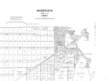 Sunshine and District Historical Society Incorporated
Map - Mambourin County of Bourke 1958 Map, Department of Lands and Survey Malbourne, 1958
... Map Mambourin County of Bourke 1958 Map...Mambourin County of Bourke 1958 Map|Township Of Werribee|Black Forest...Mambourin Mambourin County of Bourke 1958 Map|Township Of Werribee|Black Forest Map Mambourin County of Bourke 1958 Map Map Mambourin County of Bourke 1958 Map Department of Lands and Survey Malbourne ...Mambourin County of Bourke 1958 Map|Township Of Werribee|Black Forestmambourin -
 Sunshine and District Historical Society Incorporated
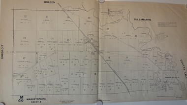
Map - Maribyrnong County Of Bourke Sheet 2 M46 1957, Department of Lands and Survey, 1957
... Cloth map of Maribyrnong County of Bourke Sheet 2...Maribyrnong County Of Bourke Sheet 2 M46 Prepared by Department of Lands and Survey...Also see Cat No 802 & 876 County of Bourke Map Maribyrnong Maribyrnong County Of Bourke Sheet 2 M46 Prepared by Department of Lands and Survey Cloth map of Maribyrnong County of Bourke Sheet 2 Map Maribyrnong County Of Bourke Sheet 2 M46 1957 Department of Lands and Survey ...Also see Cat No 802 & 876Maribyrnong County Of Bourke Sheet 2 M46 Prepared by Department of Lands and Survey county of bourke, map, maribyrnong -
 Sunshine and District Historical Society Incorporated
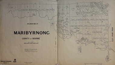
Map - Maribyrnong County Of Bourke Sheet 1 M46 1957, Department of Lands and Survey, 1957
... Cloth map of Maribyrnong County of Bourke Sheet 1...Maribyrnong County Of Bourke Sheet 1 M46 Prepared by Department of Lands and Survey...Also see Cat No 802 & 877 County of Bourke Map Maribyrnong Maribyrnong County Of Bourke Sheet 1 M46 Prepared by Department of Lands and Survey Cloth map of Maribyrnong County of Bourke Sheet 1 Map Maribyrnong County Of Bourke Sheet 1 M46 1957 Department of Lands and Survey ...Also see Cat No 802 & 877Maribyrnong County Of Bourke Sheet 1 M46 Prepared by Department of Lands and Survey county of bourke, map, maribyrnong