Showing 290 items matching "documents - maps/plans"
-
 Bendigo Military Museum
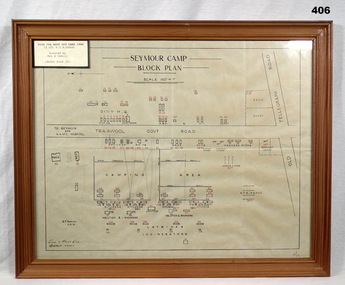
Map - PLAN, FRAMED
... documents - maps/plans...Refer Cat No 2039 for his Service History. documents - maps/plans military history - army frames Plan, detailing Seymour Camp Block Plan, Signals 7th Aust Div Camp 1940, re LT COL BENJAMIN THOMAS ROY CHADD. ...LT COL BENJAMIN THOMAS ROY CHADD No's 10594, VX20311, 1st and 2nd AIF. Refer Cat No 2039 for his Service History.Plan, detailing Seymour Camp Block Plan, Signals 7th Aust Div Camp 1940, re LT COL BENJAMIN THOMAS ROY CHADD. Tan coloured frame, glass front, cardboard backing, detail of camp layout, scale 160' = 1".documents - maps/plans, military history - army, frames -
 Glen Eira Historical Society
Document - NEERIM ROAD RAILWAY CROSSING AND GATES GLEN HUNTLY
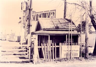
... Maps... Documents... Plans...Advertisements Graphics Advertising Advertising Signs Signs Estate Agents Business People Stockdale and Leggo Buildings Structures and Establishments Occupations United Signs Signs Communication Devices Motor Vehicles Glenhuntly Railway Station Town Planning Civic and Landscape Art Engineers Professionals Traffic Road Transport Transport Maps Documents Plans Document NEERIM ROAD RAILWAY CROSSING AND GATES GLEN HUNTLY ...This file contains two items: 1/Twelve photographs of the Glen Huntly, Neerim Road hand-operated railway gates, dated 1983 and November 1985, photographer unknown, and two black and white copies of two of the original photographs. Four photographs are in black and white and eight are in colour, all picturing the Gatekeeper’s shelter and/or the railway gates. Six photographs dated 1985 include the Gatekeeper, unidentified, in some photos operating the gates. 2/A three-page pamphlet dated 03/05/1979 promoting a public meeting at the Caulfield Town Hall to debate Road Grade Separation proposals for the Neerim Road and Glenhuntly Road railway crossings. Document details the proposed VicRail improvement and four alternative improvements as we as a blank questionnaire for the submission of ideas regarding the proposals to the Caulfield City Council Urban Planner. A short summary of other concerns held by two councillors and an engineer regarding the proposal is also included, as is a Railway Noise Level. Railway Pamphlet also includes a map of the area surrounding the railway crossings under discussion 1977.glenhuntly road, neerim road, caulfield, railway gates, gates, hand-operated railway gates, railways, roads and streets, railway crossings, architectural features, town halls, official buildings, vicrail, meetings, public meetings, caulfield town hall, gatekeepers, caulfield city council, elsternwick, glen huntly, caulfield park, caulfield racecourse, normanby road, dandenong road, railway buildings, railway stations, land transport, transport establishments, hordern a.g., dunstan don, hordern bill, needham j.g., advertisements, graphics, advertising, advertising signs, signs, estate agents, business people, stockdale and leggo, buildings structures and establishments, occupations, united signs, signs, communication devices, motor vehicles, glenhuntly railway station, town planning, civic and landscape art, engineers, professionals, traffic, road transport, transport, maps, documents, plans -
 Warrnambool and District Historical Society Inc.
Documents, Late 20th, early 21st centuries
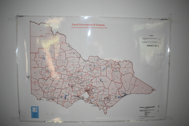
... These ten documents (maps, plans, photographs) mostly come from the Warrnambool City Council and most contain information on sub-divisions and titles of properties in areas around the Central Business District of Warrnambool. ...Warrnambool and District Historical Society Inc. 2 Gilles Street (south of Merri St) Warrnambool great-ocean-road These ten documents (maps, plans, photographs) mostly come from the Warrnambool City Council and most contain information on sub-divisions and titles of properties in areas around the Central Business District of Warrnambool. ...These ten documents (maps, plans, photographs) mostly come from the Warrnambool City Council and most contain information on sub-divisions and titles of properties in areas around the Central Business District of Warrnambool. The dates range from 1986 to 2006. These maps, plans and photographs are of some interest as they give historical details of subdivisions in Warrnambool and date from the late 20th century. .1 This is a laminated map of the boundaries of Local Governments in Victoria. It is Sheet I of 2 and has red and blue pencil markings and black boundary markings. .2 This is a copy of a plan of a survey in black and white markings on paper. .3 This is a plan of the title details of Section 19 Warrnambool. It has black printing on buff-coloured paper. .4 This is a plan of the allotments in part of the Central Business District of Warrnambool. It is printed in black and white. .5 This is a 2006 coloured aerial photograph of the harbour at Warrnambool – Breakwater etc. .6 This is a 2006 coloured aerial photograph of the Lake Pertobe area in Warrnambool .7 This is a coloured aerial photograph of Warrnambool’s streets over-stamped with road numbers in large blockings. .8 This is a plan showing the title details of Section 11 in Warrnambool. It has black printing on buff-coloured paper. .9.1 This is a plan of sub-divisions in parts of Crown Allotments 38 & 39 in Warrnambool. It has green, pink and yellow markings with black printing. .9.2 This is a plan of the sub-divisions in parts of Allotments 38 & 39 in Warrnambool. It has pink, yellow and blue markings with black printing. It is somewhat faded. warrnambool c.b.d. maps and plans, history of warrnambool -
 Croydon Conservation Society Inc.
Archive, Eastfield Estate Ringwood - Archive Collection - Parent Record
... Archive records; documents, plans, maps etc relating to the Eastfield Estate in Ringwood...Archive records; documents, plans, maps etc relating to the Eastfield Estate in Ringwood Eastfield Estate Ringwood - Archive Collection - Parent Record Archive ...Archive records; documents, plans, maps etc relating to the Eastfield Estate in Ringwood -
Croydon Conservation Society Inc.
Archive, Hewish Estate Croydon - Archive Collection - Parent Record
... Archive records; documents, plans, maps etc relating to the Hewish Estate in Croydon...Archive records; documents, plans, maps etc relating to the Hewish Estate in Croydon Hewish Estate Croydon - Archive Collection - Parent Record Archive ...Archive records; documents, plans, maps etc relating to the Hewish Estate in Croydon -
Croydon Conservation Society Inc.
Archive, Barina Estate, Whitehorse Road, Croydon - Archive Collection - Parent Record
... Archive records; documents, plans, maps, relating to Barina Estate, Whitehorse Road, Croydon...Archive records; documents, plans, maps, relating to Barina Estate, Whitehorse Road, Croydon Barina Estate, Whitehorse Road, Croydon - Archive Collection - Parent Record Archive ...Archive records; documents, plans, maps, relating to Barina Estate, Whitehorse Road, Croydon -
Croydon Conservation Society Inc.
Archive, Garden Suburb Estate, Croydon - Archive Collection - Parent Record
... Archive records; maps, plans, documents relating to Garden Suburb Estate, Croydon...Archive records; maps, plans, documents relating to Garden Suburb Estate, Croydon Garden Suburb Estate, Croydon - Archive Collection - Parent Record Archive ...Archive records; maps, plans, documents relating to Garden Suburb Estate, Croydon -
Tarnagulla History Archive
Set of Maps (Mining & Local Area), various
... A set of mining documents, maps and plans: 1. Dunolly Deep Leads - showing location and names of deep lead gold deposits in region around Dunolly including at Tarnagulla and Newbridge. ...A set of mining documents, maps and plans: 1. Dunolly Deep Leads - showing location and names of deep lead gold deposits in region around Dunolly including at Tarnagulla and Newbridge. ...David Gordon Collection. A set of mining documents, maps and plans: 1. Dunolly Deep Leads - showing location and names of deep lead gold deposits in region around Dunolly including at Tarnagulla and Newbridge. Geological Survey of Victoria, Department of Minerals and Energy. Bulletin No. 62, Map No. 4 Dunolly (770 x 485 mm). 2. Poseidon Lead (Facsimile) 3. Nick O Time Lead (Facsimile) 4. Happy Go Lucky Mine prospectus and plan (colour copy) 5. Jones Creek GM Co. (Raven & Gourlay's) Waanyarra - Prospectus (colour copy) 6. Poseidon Area Plan (colour copy) and Poseidon Area map (B&W copy). 7. Cross-section diagram of Spread Eagle Reef 8. New Birthday Gold Mine - area map (colour copy) and mine cross-section ( (colour copy). 9. Cross section of Poverty Reef, by Department of Mines (B&W copy, 2 parts on A2 paper) 10. Time-Lease Graph for Watts Reef, Specimen Reef, Stony Reef, Poverty Reef (second page in detail), created by Eric WIlkinson for Ref Mining NL, 1995 11. 1859 Plan of the Gold Workings & Township of Sandy Creek, Shewing the Mining Leases, Extended Claims & Machinery by R.J. McMillan, Mining Surveyor (B&W copy) 12. Longitundinal and Transverse Vertical Sections of Poverty Reef, Sandy Creek 1859, by R.J. McMillan, Mining Surveyor (B&W copy) 13. Tarnagulla Locality Plan (B&W copy) 14. Universal Grid Reference Map (Topographic) for Laanecoorie North (2 copies) 15. Universal Grid Reference Map (Topographic) for Inglewood South 16. Poverty Reef, Plan showing shafts and early tenements, created by Eric WIlkinson for Ref Mining NL, 1995 17. Locality Map of mining leases in Tarnagulla 18. Plan and Elevation of part of Poverty Reef, Sandy Creek, showing the claims and positions of the shaft. by R.J. McMillan, Mining Surveyor (Facsimile, composed of taped together components) 19.Plan and Elevation of part of Poverty Reef, Sandy Creek, showing the claims and positions of the shaft. by R.J. McMillan, Mining Surveyor (Facsimile, composed of taped together components) -
 Warrnambool and District Historical Society Inc.
Document - Warrnambool City Council Preliminary Report Industrial Estate West Warrnambool, E Johnson, 9 March 1973
... Mesh Pty Ltd July 2010] This document is a preliminary report prepared by the Warrnambool City Council Engineer in March 1973 and provides an example of the planning process undertaken to develop one of Warrnambool's industrial areas. It contains details and costings of the proposed subdivision. warrnambool city council west warrnambool industrial estate Two foolscaps size pages of typewritten information. A detailed topographical map ...This preliminary report relates to 32½ acres of council owned land in West Warrnambool bounded on the North by McMeekin Road, on the East by Scott Street, on the South by Evans Street and on the West by the rear boundaries of properties facing Landmann and Granter Streets. In 2010, West Warrnambool was the largest of Warrnambool’s existing industrial areas, comprising approximately 109ha of industrial zoned land, the majority of which (101ha) is zoned IN1Z, with the remainder zoned INZ3. The area comprises a mixture of lot sizes supporting a diverse mix of industries. Larger parcels are occupied by the abattoirs, scrap metal industries, freight, the Council Depot and storage. Smaller lots are occupied by smaller manufacturers and wholesalers and service industries. [Ref: Warrnambool Industrial Land Use Review. Mesh Pty Ltd July 2010]This document is a preliminary report prepared by the Warrnambool City Council Engineer in March 1973 and provides an example of the planning process undertaken to develop one of Warrnambool's industrial areas. It contains details and costings of the proposed subdivision. Two foolscaps size pages of typewritten information. A detailed topographical map of the area with areas highlighted in blue, red, green, blue and purple pen.warrnambool city council, west warrnambool, industrial estate -
 Warrnambool and District Historical Society Inc.
Documents, Swintons Paper att 18/53 Merri St. Contract. Map. Notes, 1959
... plan of the land sold. The paper has printed material and a sketch of the land with part of it coloured in pink. .3 This is a small piece of paper torn at the bottom right edge. It has handwritten material (a letter) in blue ink. Swintons Paper att 18/53 Merri St. Contract. Map. Notes Documents ...These documents relate to the sale of land in Merri Street Warrnambool in 1959 by Swintons Pty Ltd of Warrnambool. The buyer of the land was George O’Grady, a Warrnambool baker. The land sold for £4000 and there was a shed on the land (called the ‘Office’) which George O’Grady indicated he wished to be included in the sale. William and Ann Swinton migrated to Australia in 1854 and for a decade William Swinton worked as a builder and carpenter in the Warrnambool area, erecting many buildings, including the Wangoom Presbyterian Church. In 1865 he opened a store in Timor Street Warrnambool, selling groceries, hardware, china and glassware. By 1888 the business was known as William Swinton and Sons. Branch stores were opened in Wangoom, Cudgee, Nullawarre, South Warrnambool and West Warrnambool. After William Swinton died his son Robert became the first managing director of Swintons Pty Ltd. In 1934 the business split with George Swinton and Sons selling clothing, furnishings and glassware and Swintons Pty Ltd selling seeds, produce and hardware. Today the Swinton family still operates a furniture and bedding shop in Timor St Warrnambool.These items are of some interest as being connected to the Warrnambool business of Swintons Pty Ltd. They will be of interest to researchers. The current Swinton business in Timor Street is the oldest family business in Warrnambool and, with the name Swinton associated with businesses in Timor Street Warrnambool for 152 years it is amongst the oldest family businesses in Australia.The items here relate to the sale of land by Swintons Pty Ltd., Warrnambool. .1 These are three pages of white paper with typed material, a lawyer’s signature in blue ink, one green stamp and a sketch of the land location. .2 This is a sheet of thick paper containing a plan of the land sold. The paper has printed material and a sketch of the land with part of it coloured in pink. .3 This is a small piece of paper torn at the bottom right edge. It has handwritten material (a letter) in blue ink..2 ‘Plan of Survey of Part of Crown Allotment 18 Section 3 Township of .2 ‘Plan of Survey of Part of Crown Allotment 18 Section 3 Township of Warrnambool Parish of Wangoom County of Villiers’ .3 ‘Tuesday Dear Mr Swinton I am writing to say that I would like to have the ‘Office’ Thanking You George O’Grady’swinton family,, warrnambool -
 Warrnambool and District Historical Society Inc.
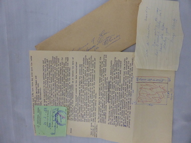
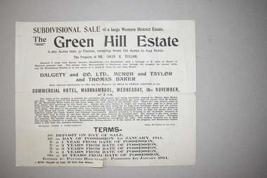
Documents (2), 1 1915 .1 1910
... map or plan of a property and black printing. The paper is creased and torn slightly at the edges. 2 A single sheet of white paper with a map of a property on one side and black printing on the other. The paper is creased and torn at the edges. Documents ...These documents come from a collection of material from the Baulch families of Dunmore and Rose Park estates in Western Victoria in the Macarthur district. They concern the sales of the Green Hills Estate (1910) and the Olangolah estate (1915) near Woolsthorpe. Both were offered for sale by the owner, Colin Tulloh. The properties bordered on Baulch property belonging to Stan Baulch (1897-1980) and hence this is the reason for their being included in Baulch estate material. These items are of minor interest and will be useful to researchers as they show the sizes and some owners of some early 20th century Western District properties. .1 A single sheet of white paper with a map or plan of a property and black printing. The paper is creased and torn slightly at the edges. 2 A single sheet of white paper with a map of a property on one side and black printing on the other. The paper is creased and torn at the edges. The Green Hills Estate Western District Estate ‘Olangolah’ western district estates, warrnambool, olongolah estate, green hills estate -
 Warrnambool and District Historical Society Inc.
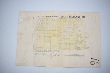
Original Document, Map: Agricultural area of Ballangeich 1865, 1865
... This map is typical of many which were produced in the 1860's in Victoria during a significant period of Victoria's and Warrnambool district history. history of warrnambool ballangeich Land surveys Victoria 1865 Lands Act 1865 Victoria Ballangeich map 1865 At the top: Plan of the Agricultural area of Ballangeich 1865 At the bottom left: Prepared by the Board of Lands & Works in accordance with the Amending Land Act 1865 Lands & Survey Office Melbourne 13th April 1865. With signature Rectangular light card paper with black text showing allotments of land The area is coloured in green with scale at bottom right corner Map: Agricultural area of Ballangeich 1865 Original Document ...George Eddington arrived in Australia in 1839 and named and established property in 1841 calling the property Ballangeich after a Pass near his home town of Stirling in Scotland. It is situated 151 miles west of Melbourne and to the south of Mortlake and was originally part of the Mortlake shire, which was proclaimed 26th Jan 1864. Nearest streams are the Hopkins Riverand Lyall and Drysdale creek running through good agricultural land. This map relates to the breaking up of large runs which the Victorian government enabled through selection acts of the 1860's. The previously larger runs which were mainly cattle and sheep based were now more open to closer settlement and a greater variety in farming.The lots range in size from approximately 50 acres to around 600 acres.Some areas are set aside for reserves. By 1886 the population of Ballangeich had grown to around 600 with an hotel, three state schools and a church.Tri weekly coaches ran to Colac, Warrnambool and Camperdown providing access to supplies mail and communication. This map is typical of many which were produced in the 1860's in Victoria during a significant period of Victoria's and Warrnambool district history.Rectangular light card paper with black text showing allotments of land The area is coloured in green with scale at bottom right cornerAt the top: Plan of the Agricultural area of Ballangeich 1865 At the bottom left: Prepared by the Board of Lands & Works in accordance with the Amending Land Act 1865 Lands & Survey Office Melbourne 13th April 1865. With signaturehistory of warrnambool, ballangeich, land surveys victoria 1865, lands act 1865 victoria, ballangeich map 1865 -
 Warrnambool and District Historical Society Inc.
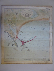
Document - Map, Warrnambool Harbour 1879, 1879
... map 1879 In oval at top, “Victorian Harbours Warrnambool plan to accompany Sir John Coode report dated 28th Feb 1879. Drawing No 2. Scale 500 feet to 1 inch at bottom centre. Sir John Coode signature in bottom left corner. A 33 A on bottom left reverse Paper on linen map coloured, and depicting the harbour area of Warrnambool with the proposed breakwater plan in red. It has Victorian Harbours information in oval at top of map. It shows depths of some areas. Warrnambool Harbour 1879 Document ...This map shows the plans by eminent harbour engineer, Sir John Coode in 1879. Construction of the breakwater commenced in 1884 and was completed in 1890. Coode first visited Australia in 1872 when he commenced work with the Melbourne Harbour Trust to report on ways to improve Melbourne Port. He is considered one of the most eminent harbour engineers of the 19th century. His original plans for Warrnambool were revised because of cost but then subsequently found to be inadequate and later extended. This was not successful either and the harbour continues to have silting problems to this day. The Warrnambool Breakwater is of historical importance to Victoria and as this map depicts the original plans, it too has great historical significance. It is also significant with its association with Sir John Coode, who was one of the most important port engineers of the 19th century. He worked to improve ports along the Victorian coast including Portland, Geelong, Port Fairy and Lakes Entrance. While this map demonstrates the engineering skills of the era, it also reflects the limitations when natural elements are involved. Its Historical importance also lies in the depiction of items on the map which relate to Warrnambool’s early history. Paper on linen map coloured, and depicting the harbour area of Warrnambool with the proposed breakwater plan in red. It has Victorian Harbours information in oval at top of map. It shows depths of some areas.In oval at top, “Victorian Harbours Warrnambool plan to accompany Sir John Coode report dated 28th Feb 1879. Drawing No 2. Scale 500 feet to 1 inch at bottom centre. Sir John Coode signature in bottom left corner. A 33 A on bottom left reversesir john goode, warrnambool harbour map, warrnambool harbour map 1879, port of warrnambool map 1879 -
 Bendigo Military Museum
Document - RENOVATION SPECIFICATIONS BRSL, C. 1962 onwards
... plans. This ceiling was removed during the 2016 - 2018 major renovations to the SMI. The false ceiling in the Office was removed in a major renovation to the room in 2011 - 2012 and taken back to original. Brsl renovations Smirsl On front cover in black pen. "Specifications - Painting & Renovations R.S.L. Premises Pall Mall, Bendigo" Folder brown card covers with six typed in black pages and one map all black print, pages stapled in with 2 binder holes in. Document ...These renovations were first discussed by the Bendigo RSL in 1962 - 1963. This Document is headed, “Specifications of Workmanship and Materials required for Painting and Renovations etc, at R.S.S.A.I.L.A Hall, Pall Mall, Bendigo” There are 3 parts to the documents. First section has 22 parts, everything from “Tender - Insurance - Materials - Liability - Condition of Contract to the use of Sanitary conveniences. Second section has sections re “Carpenter and Joiner - Brick work - Plastering - Electrician - Painter and Glazier”. Each has sections under re their work to be done. Third section is a technical drawing of the Soldiers Memorial Institute minus the Main Hall, it shows scopes of work. The main works covered a new false ceiling in the Office, a new front door entrance to the Foyer in a different position, exhaust fan in the Billiard room, removal of a gate at the Stairwell entrance, fire place repairs, adding chair rails to walls to foyer, Committee room. These works were carried out. There was a false ceiling in the Meeting room but there was no mention re this in the above plans. This ceiling was removed during the 2016 - 2018 major renovations to the SMI. The false ceiling in the Office was removed in a major renovation to the room in 2011 - 2012 and taken back to original.Folder brown card covers with six typed in black pages and one map all black print, pages stapled in with 2 binder holes in.On front cover in black pen. "Specifications - Painting & Renovations R.S.L. Premises Pall Mall, Bendigo"brsl, renovations, smirsl -
 Bendigo Military Museum
Photograph - Visit by the Chief of the General Staff to the Army Survey Regiment, Fortuna, Bendigo, 1979
... planning documents. CAPT Don Maskew in background. .8) - Photo, black and white, 1979. Tour of Cartographic Squadron. L to R: CPL Dennis Learmonth, acting OC CAPT Bob Roche, CAPT Eddy Schulze, LTGEN General Sir Donald Dunstan AC, KBE CB; SSGT John ‘JB’ Barrie discuss cartographic map compilation procedures .9) - Photo, black and white, 1979. ...planning documents. CAPT Don Maskew in background. .8) - Photo, black and white, 1979. Tour of Cartographic Squadron. L to R: CPL Dennis Learmonth, acting OC CAPT Bob Roche, CAPT Eddy Schulze, LTGEN General Sir Donald Dunstan AC, KBE CB; SSGT John ‘JB’ Barrie discuss cartographic map compilation procedures .9) - Photo, black and white, 1979. ...This is a set of 14 photographs of a visit to the Army Survey Regiment, Fortuna, Bendigo on the 5th of June 1979 by the Chief of the General Staff (CGS) Lieutenant General Sir Donald Dunstan AC, KBE, CB. He was accompanied by his wife. They were escorted through the production areas of the Army Survey Regiment by the CO LTCOL Bob Skitch. Lieutenant General Sir Donald Dunstan AC, KBE, CB was an esteemed Australian Army officer, who was CGS from 1977 to 1982. Upon retirement from the Army in 1982, he was appointed to the position of Governor of South Australia from 1982 to 1991. LTCOL Bob Skitch was the CO of the Army Svy Rgt from 1976 to 1980. Also featuring in these photos is MAJ Peter Eddy, who was the OC of Air Survey Squadron. He was later promoted to LTCOL and was CO of the Army Svy Rgt from 1981 to 1982. See item 6035.9P for photos of the CGS’s presentation of the Defence Force Service Medal to four recipients.This is a set of 14 photographs of a visit by the Chief of the General Staff to the Army Survey Regiment Fortuna, Bendigo on the 5th of June 1979. The photographs were printed on photographic paper and are part of the Army Survey Regiment’s Collection. They were scanned at 300 dpi. .1) - Photo, black and white, 1979. Tour of Air Survey Squadron. L to R: unidentified, LTGEN General Sir Donald Dunstan AC, KBE, CB; OC MAJ Peter Eddy, unidentified. .2) - Photo, black and white, 1979. Tour of Air Survey Squadron. LTGEN General Sir Donald Dunstan AC, KBE, CB; views 3D stereoscopic aerial photography on a Zeiss (Jena) Stecometer. OC MAJ Peter Eddy is on his right. .3) - Photo, black and white, 1979. Tour of Air Survey Squadron. L to R: unidentified, CO LTCOL Bob Skitch, OC MAJ Peter Eddy, LTGEN General Sir Donald Dunstan AC, KBE CB viewing an aerial photograph. WO1 Brian Mead and others are operating a Wild PUG4 point transfer device. .4) - Photo, black and white, 1979. Enlargement of photo .3). Tour of Air Survey Squadron. L to R: unidentified, CO LTCOL Bob Skitch, OC MAJ Peter Eddy, LTGEN General Sir Donald Dunstan AC, KBE CB viewing an aerial photograph. .5) - Photo, black and white, 1979. Tour of Air Survey Squadron. LTGEN General Sir Donald Dunstan AC, KBE, CB; and unidentified technician view 3D stereoscopic aerial photography on a Wild B8 stereo plotter. .6) - Photo, black and white, 1979. Tour of Air Survey Squadron. L to R: OC MAJ Peter Eddy LTGEN General Sir Donald Dunstan AC, KBE CB; CO LTCOL Bob Skitch, view the output of a verification plot on an AUTOMAP 1 Gerber 1442 drum plotter. .7) - Photo, black and white, 1979. Tour of Air Survey Squadron. L to R: CO LTCOL Bob Skitch, unidentified aide de camp officer, LTGEN General Sir Donald Dunstan AC, KBE CB; OC MAJ Peter Eddy discuss aero triangulation planning documents. CAPT Don Maskew in background. .8) - Photo, black and white, 1979. Tour of Cartographic Squadron. L to R: CPL Dennis Learmonth, acting OC CAPT Bob Roche, CAPT Eddy Schulze, LTGEN General Sir Donald Dunstan AC, KBE CB; SSGT John ‘JB’ Barrie discuss cartographic map compilation procedures .9) - Photo, black and white, 1979. Tour of Cartographic Squadron. L to R: Tech WO WO1 Roger Rix, acting OC CAPT Bob Roche, CAPT Eddy Schulze, unidentified visitor, Mrs Dunstan with examples of map products. .10) - Photo, black and white, 1979. Tour of Cartographic Squadron. L to R: CPL Terry Danger, CO LTCOL Bob Skitch, LTGEN General Sir Donald Dunstan AC, KBE CB; discuss terrain embossing (hill shading) procedures. .11) - Photo, black and white, 1979. Tour of Cartographic Squadron. L to R: CO LTCOL Bob Skitch, LTGEN General Sir Donald Dunstan AC, KBE CB; acting OC CAPT Bob Roche, SSGT Dick Manley, CAPT Don Maskew and CAPT Steve Cooper in background. SPR Cheryl Lofthouse is retouching blemishes on a map separation film negative. .12) - Photo, black and white, 1979. Tour of Lithographic Squadron. L to R: CAPT Stan Vote, unidentified aide de camp officer, CO LTCOL Bob Skitch, LTGEN General Sir Donald Dunstan AC, KBE CB; MAJ Sam Schwartz EXCH-US, LT John Harrison discuss bulk map printing processes with an Ultra-MAN-III Printing Press. .13) - Photo, black and white, 1979. Officers Mess L to R: LTGEN General Sir Donald Dunstan AC, KBE CB; with CO LTCOL Bob Skitch. .14) - Photo, black and white, 1979. Officers Mess L to R: MAJ Peter Eddy, LTGEN General Sir Donald Dunstan AC, KBE CB..1P to .14P – no annotationsroyal australian survey corps, rasvy, army survey regiment, army svy regt, fortuna, asr -
 Bendigo Military Museum
Administrative record - Royal Australian Survey Corps Planning Conference 1972 - Standard of Compilation sheets by Army Survey Regiment, Army Survey Regiment, Bendigo, 03.10.1972
... Planning Conference 1972 by the Army Survey Regiment held at Fortuna Bendigo. It was intended to provide a trouble shooting guide for personnel engaged in the production of map compilation sheets. See also item Number 6517 "Standard of Compilation Sheets" by LtCol DR Ridge (RASvy) Royal Australian Survey Corps RASvy Fortuna Army Survey Regiment Army Svy Regt ASR 26 x A4 page document containing typed text diagrams and copied map extracts, photocopies and Oza film. ...This booklet was prepared for the Royal Australian Survey Corps Planning Conference 1972 by the Army Survey Regiment held at Fortuna Bendigo. It was intended to provide a trouble shooting guide for personnel engaged in the production of map compilation sheets. See also item Number 6517 "Standard of Compilation Sheets" by LtCol DR Ridge (RASvy)26 x A4 page document containing typed text diagrams and copied map extracts, photocopies and Oza film. Item is four hole puched and is held together by an ARNOS Fastenerroyal australian survey corps, rasvy, fortuna, army survey regiment, army svy regt, asr -
 Bendigo Military Museum
Plan - MAP, TOURIST, L Joly, A Maunier, WWI
... Refer 1317P, 1320P. documents-maps french "Plan commode de Paris avec l'itineraire des autobus & tramways metropolitan" Map of Paris. ...The map belonged to Jack Grinton No 1043 38th Batt AIF. At Wars end extensive leave was granted, Jack journeyed to Paris, Nice, Monte Carlo taking many photos. Part of the Grinton collection which included hundreds of negatives and developed photos that he took during the War. Refer Cat No 1280 for service details. Refer 1317P, 1320P.Map of Paris. Red cardboard or paper hardcover, new edition guide of metropolitan Paris (ministries, tramways, monuments), Index in front, folded paper map attached to back cover. "Plan commode de Paris avec l'itineraire des autobus & tramways metropolitan"documents-maps, french -
 Blacksmith's Cottage and Forge
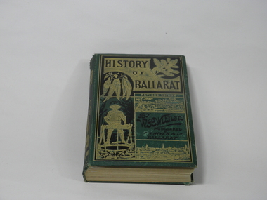
Book, F.W. Niven and Co, History of Ballarat, 1887
... Plans, Ilustrations and Original Documents. It is an invaluable history of the origins of Ballarat and its mining history, with a chapter devoted to the Eureka Stockade. Ballarat gold rush W.B.Withers Eureka Stockade mining history early maps ...This book came into our collection via a donation to the Book Barn, which operates as a second-hand book shop. The donor is unknown.This book was published in 1887, a time of consolidation of wealth after the initial gold rushes in Ballarat in the 1850s. Its full title is 'History of Ballarat from the First Pastoral Settlement to the Present Time.' By William Bramwell Withers, Journalist. Second Edition with Plans, Ilustrations and Original Documents. It is an invaluable history of the origins of Ballarat and its mining history, with a chapter devoted to the Eureka Stockade. Book bound in green cloth on hard cover. On cover: Title incised in black on gold: HISTORY/OF/BALLARAT In gold: REVISED EDITION In black:By/W.B.Withers/PUBLISHED/BY/F.W.NIVEN &Co/Ballarat. Front cover embossed with gold pictures, one of a spray of wattle, one of a spray of eucalyptus leaves, a picture of a miner standing at a winch, and two panoramas of Ballarat, one in its early days as a gold-mining camp, and one as a built-up city. On spine: In green on gold: HISTORY/OF/BALLARAT : BY W.B.WITHERS 1887 Picture of two miners in a lift cage descending a mine shaft. On back cover: In black, picture of an aborigine looking into the sun, which is either rising or setting. On inside front cover: label pasted in. Inscription in gold: PRESENTED TO/THE/MEMBERS/OF THE/Empire Commerce Congress/BY/BALLARAT'S PIONEER DIGGER,/MR.JAMES ODDIE,1851. Front brown flyleaf partially torn off. ballarat gold rush, w.b.withers, eureka stockade, mining history, early maps of ballarat, mr james oddie, empire commerce congress -
 Eltham District Historical Society Inc
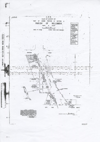
Document - Survey Plan, Country Roads Board et al, SP 12272A, Eltham-Yarra Glen Road; Brougham St to Dalton St, 1970-1976
... Skipper Main Road Eltham Map Maria Street Matcham Skipper Mobil Service Centre (Eltham) Mobil Service Station Napoleon Street Survey Plan White Cloud Cottage Country Roads Board A3 print, 2 pages SP 12272A, Eltham-Yarra Glen Road; Brougham St to Dalton St Document Survey Plan Country Roads Board John L. ...1970 C.R.B. Plan of Survey of Part of Crown Portion 12 Section 4 Parish of Nillumbik, County of Evelyn Eltham-Yarra Glen Road, Shire of Eltham Shows Surveyor field notes, property ownership and building type and construction. John L. Roberts, Licensed Surveyor as noted 4 June 1970 Amendments in black by John L. Roberts, L.S. 20-12-76 See also EDHS_05783 (1958)eltham-yarra glen road, 1970, 1976, a.f. munday, brougham street, dalton street, eltham, eltham clinic, g.t. & e.a. donnelly, jarrold cottage, l.m. jarrold, m.s.m. skipper, main road eltham, map, maria street, matcham skipper, mobil service centre (eltham), mobil service station, napoleon street, survey plan, white cloud cottage, country roads board -
 Eltham District Historical Society Inc
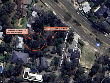
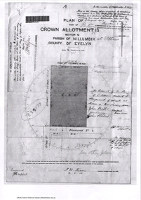
Document - Property Binder, 338 Main Road, Lower Plenty (also 37 Rangeview Road), March 2025
... Goodison, Licensed Surveyor, and attached Surveyor's Report dated 6 June 1990 Notes: Items 1 to 6 donated electronically Items 7 to 9 sourced from LASSI - SPEAR, Department of Transport and Planning, Victoria State Government, https://maps.land.vic.gov.au/lassi/SpearUI.jsp Main Road Property Mudbrick David Newbury Phoebe Mason Collection Rate Books shire of eltham Certificate of Title Survey Plan 37 Rangeview Road 338 Main Road Application 23911 Lower Plenty Map Surveyor Field Notes Application 221805 Application 222467 Miscellaneous electrionic records, clippings, notes, photocopies, etc held on the subject property. 338 Main Road, Lower Plenty (also 37 Rangeview Road) Document Property Binder ...EDHS_03095-338 | EDHS_08635-37 338 Main Road Lower Plenty | 37 Rangeview Road, Lower Plenty Original Mudbrick cottage and studio designed and built by Eltham artist, David Alan Newbury See also EDHS_06090 David Newbury (Artist) David Newbury was married to Clare Margaret Newbury. According to the 1954 Electoral Roll they were living at 36A Murphy Street, South Yarra however around 1953 they purchased Lots 3 and 4 of Main Road Lot Plan LP 23911 in Lower Plenty. A building permit, No. 71, was issued 8 December 1953 for a 5-room house of Vertical Board construction, cost £2,840, builder L. Williams, owner D. Newbury of 36 Murphy Cl., South Yarra. The large house was in fact mostly built of mudbrick, the construction method was only just becoming recognised as an acceptable form in the late 1940s for issuance of a building permit. The house was commenced in 1954, designed by David Newbury and built by David Newbury, Horrie Judd and others. Information from Newbury family friends suggests that a second mudbrick building was constructed in the late 1950s, early 1960s for use as an artist studio by Newbury. The building was connected directly to the water mains at the time and was made suitable for living accommodation during the period Newbury was teaching at Bendigo. Apparently he and Claire rented out the main house during their time in Bendigo and would reside in the studio when visiting Melbourne. No permit for this studio was found in the Building Permit Register, Shire of Eltham, 1949-1960. The last recorded entries in the register are dated May 1960. This would suggest that the studio was constructed post May 1960. It is believed the studio was constructed during the latter period of Newbury’s teaching post in Bendigo so possibly late 1960/1961. In 1963 the Newbury’s address in the Electoral Roll has the property recorded as 220 Main Road, Lower Plenty. Between 1967 to 1980 the Electoral Rolls record the property as 338 Main Road. Today the address is 37 Rangeview Road, Lower Plenty. Contents: 1. Extract from 1942 Shire of Eltham Rate Book. Muriel Gladys Reitsma listed as owner 2. Extract from 1984-85 Shire of Eltham Rate Book for Rangeview Road. (No mention of No. 37 so was probably still listed as 338 Main Road.) 3. Certificate of Title, Vol. 5601 Fol. 1120089 - Issued to David James Graham of Lower Plenty, Builder, Heidelberg for Lot 32 Block B on Plan of Subdivision No. 7606, part of Crown Portion Two, Parish of Nillumbik, County of Evelyn, 29 October 1929 4. Certificate of Title, Vol. 8008 Fol. 076 - Issued to David Alan Newbury of 36 Murphy Street, South Yarra, School Teacher for Lot 3 on Plan of Subdivision No. 23911, part of Crown Portion Two, Parish of Nillumbik, County of Evelyn, 29 October 1953. Amended 24 June 1963 to transfer portion for road widening scheme per Country Roads Board Plan 6889 - Cancelled 24 September 1984 5. Certificate of Title, Vol. 9581 Fol. 583 - Issued to Paul Robert Biber and Althea Constance Biber of 139 Lower Heidelberg Road, Ivanhoe for Lot 3 on Plan of Subdivision No. 23911, part of Crown Portion Two, Parish of Nillumbik, County of Evelyn, 24 September 1984. Derived from Vol. 8008 Fol. 076 L276994V - Cancelled 20 Nov 1992 when subdivided from one to two lots in Vol 10092 Fol. 192 and Vol. 10092 Fol. 193; LP222467B 6. Certificate of Title, Vol. 10092 Fol. 192 - Transfer to Lawrie Mein of 20 Dewar Drive, Hurstbridge of Lot 1 on Plan of Subdivision No. 222467B, lodged 17 Feb 1993, Registered 29 March 1996. Parent Titles Vol 08008 Fol 077, Vol 09581 Fol 583 7. Survey Field Notes of Part of Crown Portion 2, Parish of Nillumbik, County of Evelyn - Portion of land bounded by New Eltham Road. Application 23911 dated 8 Sep 1952 with appended Surveyor Field notes per Application 7098; R.D. Steele, Licensed Surveyor, 18 August 1950 8. Survey Field Notes of Part of Crown Portion 2, Parish of Nillumbik, County of Evelyn - Portion of land bounded by Main Road and Rangeview Road; 2 Lot subdivisions, Vol. 9581 Fol. 583 Part Lot 3 on LP 23911 and Vol. 8008 Fol, 077 Lot 4 on LP 23911; Application 221805 dated 27 November 1989; W.J. Goodison, Licensed Surveyor, and attached Surveyor's Report dated 6 June 1990 (Withdrawn) 9. Survey Field Notes of Part of Crown Portion 2, Parish of Nillumbik, County of Evelyn - Portion of land bounded by Main Road and Rangeview Road; 2 Lot subdivisions, Vol. 9581 Fol. 583 Part Lot 3 on LP 23911 and Vol. 8008 Fol, 077 Lot 4 on LP 23911; Application 222467 dated 20 November 1992 (221805 resubmitted); W.J. Goodison, Licensed Surveyor, and attached Surveyor's Report dated 6 June 1990 Notes: Items 1 to 6 donated electronically Items 7 to 9 sourced from LASSI - SPEAR, Department of Transport and Planning, Victoria State Government, https://maps.land.vic.gov.au/lassi/SpearUI.jsp main road, property, mudbrick, david newbury, phoebe mason collection, rate books, shire of eltham, certificate of title, survey plan, 37 rangeview road, 338 main road, application 23911, lower plenty, map, surveyor field notes, application 221805, application 222467 -
 Eltham District Historical Society Inc
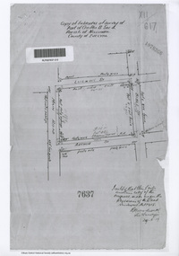
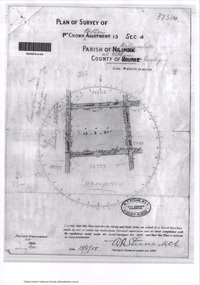
Document - Photocopy, Survey Field Notes of Part of Crown Portion 13, Section 4 at Eltham, Parish of Nillumbik, County of Evelyn, 29 May 1919
... Woodcock, Licensed Surveyor, 29 May 1919 1919 Application 7637 Arthur Street Bible Street Luck Street Main Road Eltham Map Neil Webster Collection Survey Plan Surveyor Field Notes A3 printouts, 2 pages Survey Field Notes of Part of Crown Portion 13, Section 4 at Eltham, Parish of Nillumbik, County of Evelyn Document Photocopy ...Portion of land bounded by: Main Road, Luck Street, Bible Street, Arthur Street Application 7637 R.H. Woodcock, Licensed Surveyor, 29 May 19191919, application 7637, arthur street, bible street, luck street, main road eltham, map, neil webster collection, survey plan, surveyor field notes -
 Eltham District Historical Society Inc
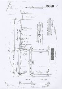
Document - Photocopy, Survey Field Notes of Part of Crown Portion 13, Section 4 at Eltham, Parish of Nillumbik, County of Evelyn, 18 October 1946
... Connolly, Licensed Surveyor, 18 October 1946 Map Neil Webster Collection Survey Plan Surveyor Field Notes 1946 Application 18650 Bible Street henry street Main Road Eltham Maria Street Rose Street A3 printout, 1 page Survey Field Notes of Part of Crown Portion 13, Section 4 at Eltham, Parish of Nillumbik, County of Evelyn Document Photocopy ...Portion of land bounded by: Main Road, Henry Street, Bible Street Application 18650 W. Connolly, Licensed Surveyor, 18 October 1946map, neil webster collection, survey plan, surveyor field notes, 1946, application 18650, bible street, henry street, main road eltham, maria street, rose street -
![Document - Photocopy, Survey Field Notes of Part of Crown Portion 13, Section 4 at Eltham, Parish of Nillumbik, County of Evelyn [Bourke sic], 30 September 1949](/media/collectors/4f729f7b97f83e03086018a5/items/6869da03f3688aa02254c5c2/item-media/6869da22f3688aa02254c6da/item-fit-380x285.jpg?cb=6) Eltham District Historical Society Inc
Eltham District Historical Society IncDocument - Photocopy, Survey Field Notes of Part of Crown Portion 13, Section 4 at Eltham, Parish of Nillumbik, County of Evelyn [Bourke sic], 30 September 1949
... Eltham District Historical Society Inc 728 Main Rd Eltham melbourne Portion of land bounded by: Main Road, Arthur Street, Dudley Street Application 21718 Erwin Dillon, Licensed Surveyor, 30 September 1949 Map Neil Webster Collection Survey Plan Surveyor Field Notes 1949 Application 21718 Arthur Street Dudley Street Main Road Eltham A3 printout, 1 page Survey Field Notes of Part of Crown Portion 13, Section 4 at Eltham, Parish of Nillumbik, County of Evelyn [Bourke sic] Document Photocopy ...Portion of land bounded by: Main Road, Arthur Street, Dudley Street Application 21718 Erwin Dillon, Licensed Surveyor, 30 September 1949map, neil webster collection, survey plan, surveyor field notes, 1949, application 21718, arthur street, dudley street, main road eltham -
 Eltham District Historical Society Inc
Document - Photocopy, Survey Field Notes of Part of Crown Portion 13, Section 4 at Eltham, Part of Lot 19 Subdivision of 13 Section IV (Holloways), Parish of Nillumbik, County of Evelyn, 5 May 1906
... Mackensie Tyers, Licensed Surveyor, 5 May 1906 Map Neil Webster Collection Survey Plan Surveyor Field Notes 1906 Application 33777 Application 35953 henry street Main Road Eltham Maria Street Rechabite Hall* A3 printouts, 2 pages Survey Field Notes of Part of Crown Portion 13, Section 4 at Eltham, Part of Lot 19 Subdivision of 13 Section IV (Holloways), Parish of Nillumbik, County of Evelyn Document Photocopy ...Portion of land bounded by: Main Road, Henry Street Application 35953 A. Mackensie Tyers, Licensed Surveyor, 5 May 1906map, neil webster collection, survey plan, surveyor field notes, 1906, application 33777, application 35953, henry street, main road eltham, maria street, rechabite hall* -
 Eltham District Historical Society Inc
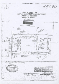
Document - Photocopy, Survey Field Notes of Part of Crown Portion 12, Section 4 at Eltham, Parish of Nillumbik, County of Evelyn, 12 August 1910
... Arndt, Licensed Surveyor, 12 August 1910 Map Neil Webster Collection Survey Plan Surveyor Field Notes 1910 Application 38858 Bible Street John Street Main Road Eltham Pitt Street A3 printout, 1 page Survey Field Notes of Part of Crown Portion 12, Section 4 at Eltham, Parish of Nillumbik, County of Evelyn Document Photocopy ...Portion of land bounded by: Main Road, John Street, Bible Street, Pitt Street Application 38858 K. Arndt, Licensed Surveyor, 12 August 1910map, neil webster collection, survey plan, surveyor field notes, 1910, application 38858, bible street, john street, main road eltham, pitt street -
 Eltham District Historical Society Inc
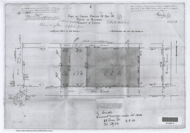
Document - Photocopy, Survey Field Notes of Part of Crown Portion 12, Section 4 at Eltham, Parish of Nillumbik, County of Evelyn, 4 July 1924
... Map Neil Webster Collection Survey Plan Surveyor Field Notes 1924 Application 46030 Bible Street Corn Store Ernie Andrew franklin street L. Grant Main Road Eltham Maria Street Peel Street Pitt Street A3 printout, 1 page Survey Field Notes of Part of Crown Portion 12, Section 4 at Eltham, Parish of Nillumbik, County of Evelyn Document Photocopy ...Portion of land bounded by: Main Road, Pitt Street, Bible Street, Franklin Street Application 46030 R.H. Woodcock, Licensed Surveyor, 4 July 1924map, neil webster collection, survey plan, surveyor field notes, 1924, application 46030, bible street, corn store, ernie andrew, franklin street, l. grant, main road eltham, maria street, peel street, pitt street -
 Eltham District Historical Society Inc
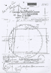
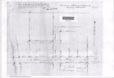
Document - Photocopy, Survey Fleld Notes of Part of Crown Portion 13, Section 4 at Eltham, Parish of Nillumbik, County of Evelyn, 1902-1903
... Eltham District Historical Society Inc 728 Main Rd Eltham melbourne Main Road, Henry Street to Diamond Street; Silver Street to Bible Street Application No. 033777 1902 1903 Arthur Street Bible Street Bird street Diamond Creek (Creek) Diamond Street Eltham Eltham Railway Station henry street Main Road silver street Survey Plan Vine street Application 33777 Map A4 printouts, 7 pages Survey Fleld Notes of Part of Crown Portion 13, Section 4 at Eltham, Parish of Nillumbik, County of Evelyn Document Photocopy ...Main Road, Henry Street to Diamond Street; Silver Street to Bible Street Application No. 0337771902, 1903, arthur street, bible street, bird street, diamond creek (creek), diamond street, eltham, eltham railway station, henry street, main road, silver street, survey plan, vine street, application 33777, map -
 Eltham District Historical Society Inc
Document - Photocopy, Survey Fleld Notes of Part of Crown Portion 13, Section 4 at Eltham, Parish of Nillumbik, County of Evelyn, 18 May 1908
... Civil Engineer and Surveyor, 18 May 1908 Application 37314 Arthur Street Bible Street Eltham Luck Street Main Road Map Survey Plan A4 printouts, 2 pages Survey Fleld Notes of Part of Crown Portion 13, Section 4 at Eltham, Parish of Nillumbik, County of Evelyn Document Photocopy ...Portion of land bounded by: Main Road, Luck Street, Bible Street, Arthur Street Application 37314 W. P. Steane, M.C.E. Civil Engineer and Surveyor, 18 May 1908application 37314, arthur street, bible street, eltham, luck street, main road, map, survey plan -
 Eltham District Historical Society Inc
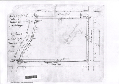
Document - Photocopy, Survey Fleld Notes of Part of Crown Portion 13, Section 4 at Eltham, Parish of Nillumbik, County of Evelyn, 31 May 1907
... Arndt, Licensed Surveyor, 31 May 1907 Application 36708 Bible Street Eltham Luck Street Main Road Map Survey Plan A4 printouts, 2 pages Survey Fleld Notes of Part of Crown Portion 13, Section 4 at Eltham, Parish of Nillumbik, County of Evelyn Document Photocopy ...Portion of land east of Main Road and north of Luck Street bounded by Bible Street Application 36708 K. Arndt, Licensed Surveyor, 31 May 1907application 36708, bible street, eltham, luck street, main road, map, survey plan -
 Eltham District Historical Society Inc
Document - Photocopy, Survey Fleld Notes of Part of Crown Portion 13, Section 4 at Eltham, Parish of Nillumbik, County of Evelyn, November 1909
... Arndt, Licensed Surveyor, November 1909 Application 5289 Arthur Street Bible Street Eltham henry street Main Road Map Survey Plan A4 printout Survey Fleld Notes of Part of Crown Portion 13, Section 4 at Eltham, Parish of Nillumbik, County of Evelyn Document Photocopy ...Portion of land bounded by Main Road, Arthur Street, Bible Street, Henry Street Application 36708 K. Arndt, Licensed Surveyor, November 1909application 5289, arthur street, bible street, eltham, henry street, main road, map, survey plan