Showing 32 items matching "early farming settlement"
-
 Bendigo Historical Society Inc.
Book - KIMBOLTON, 1976
... ...early farming settlement...History House 11 Mackenzie Street Bendigo goldfields HISTORY Australian early farming settlement Farming history. John Ormond Randell Kimbolton. ...Kimbolton. History of a Victorian sheep station from its first settlement in 1838.John Ormond Randellhistory, australian, early farming settlement, farming history. -
 Bendigo Historical Society Inc.
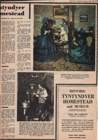
Newspaper - LYDIA CHANCELLOR COLLECTION: TYNTYNDYER HOMESTEAD
... ...early farming settlement...History House 11 Mackenzie Street Bendigo goldfields HISTORY Australian early farming settlement Lydia Chancellor Collection collection Swan Hill Aboriginal Aboriginal Contact Australia history Australian history homesteads building house houses heritage tourism Aborigines settlers weapons guns pastoralists expedition John Holloway Andrew Beveridge Peter Beveridge Robert O'Hara Burke Narrinyeri Tribe bushrangers relics National Trust advertisement exploration An article from a 'Supplement to Bendigo Advertiser' giving some insights into the history of Tyntyndyer Homestead which is in the Swan Hill district. ...An article from a 'Supplement to Bendigo Advertiser' giving some insights into the history of Tyntyndyer Homestead which is in the Swan Hill district. It gives an insight into the early settlers and their struggles for survival. There is an advertisement within the supplement advertising the 'Historic Tyntyndyer Homestead and Museum.' Coloured and black and white photographs are included in this article which is dated 12/2/1969.history, australian, early farming settlement, lydia chancellor collection, collection, swan hill, aboriginal, aboriginal contact, australia, history, australian history, homesteads, building, house, houses, heritage, tourism, aborigines, settlers, weapons, guns, pastoralists, expedition, john holloway, andrew beveridge, peter beveridge, robert o'hara burke, narrinyeri tribe, bushrangers, relics, national trust, advertisement, exploration -
 Warrnambool and District Historical Society Inc.
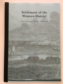
Booklet - Booklet: Settlement of the Western District, Collett, Bain and Gaspar, Printers, Settlement of the Western District From Prehistoric Times to the Present, 1985
... early maritime history, aboriginal history, architecture , archeology, farming and sociology. This book is very useful as it contains articles on various aspects of the history of Western Victoria and is of considerable help to researchers and others interested in our local history. Several of the writers (eg. Critchett, Sherwood, Lewis, Ronald, Gill) have produced other writings on our local district. western victorian history edmund gill peter ronald john sherwood jan critchett tony dingle miles lewis kevin o’toole warrnambool history This booklet documents a public lecture series held in Warrnambool 3rd November 1984. Front Cover: ‘Settlement ...This booklet documents a public lecture series held in Warrnambool 3rd November 1984.This is a soft-cover book of 133 pages on the settlement of the Western District from prehistoric times to the present. It has a blue paper front cover and a grey paper back cover. The front cover is covered with a clear plastic sheet and the binding is plastic. The cover has an image of a sketch of the Warrnambool beach showing the lighthouse complex on Middle Island and the lighthouse on the beach (established 1860). There are a Contents page, a Foreword, a List of Plates and seven articles on different aspects of the Western District history by different authors. There are black and white photographs and illustrations. One page (p.17) has been annotated by Les O’Callaghan.This booklet documents a public lecture series held in Warrnambool 3rd November 1984.western victorian history, edmund gill, peter ronald, john sherwood, jan critchett, tony dingle, miles lewis, kevin o’toole, warrnambool, history -
 Warrnambool and District Historical Society Inc.
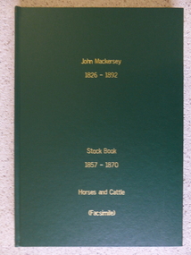
Book - Facsimile: John Mackersey 1826-1892, Stock Book 1857-1870, 2014
... farming. It records purchases and stock sold, wool clips, lambs, sheep losses and different breeds. Kenilworth was a significant property in the Western District of Victoria and it dates from a period of early settlement in Victoria. ...This ledger relates to the property Kenilworth which is situated near Cavendish, 16 miles from Hamilton on the Wannon River. It was taken up by Thomas Norris in 1839 and originally carried 800 cattle and 20000 sheep on 63000 acres. By 1858 it was in the hands of John Mackersey and Thomas Bostock. In 1859 it belonged outright to John Mackersey who was there until 1870. He was considered a worthy son of a Presbyterian minister and was well regarded in the district for his contributions in church, sport and sheep breeding... However he did not do well and lost the property before going to New Zealand in 1870. These journals provide a yearly record of flock, harvest and yields along with income details. It also provides details relating to rentals, selections and purchases during the era from squatting to freehold land. This journal provides a detailed view of matters relating to the business of sheep farming. It records purchases and stock sold, wool clips, lambs, sheep losses and different breeds. Kenilworth was a significant property in the Western District of Victoria and it dates from a period of early settlement in Victoria.Dark green hard cover with gold lettering. Both covers have in gold lettering: John Mackersey1826-1892 Stock Book 1857-1870. One cover has Horses and cattle and the other, sheep. It is a facsimile copy. The two sections are divided by a green sheet of paper. Acknowledgements to The State Government of Victoria, State Library of Victoria, Hamilton History Centre, Dr G Handbury AO, Margaret Gardiner, Godfrey and Margaret Mackersey, L Alan Brumley, M P Heuval. john mackersey, thomas bostock, thomas norris, kenilworth, history of warrnambool -
 Kiewa Valley Historical Society
Photograph - Tawonga Sports Day
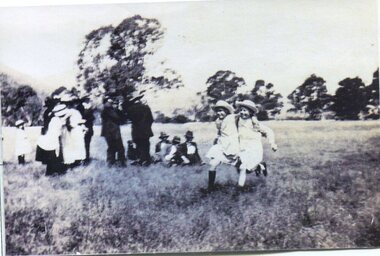
... The Ryder and Briggs families have been prominent farming families in the local area since early settlement. ...The Ryder and Briggs families have been prominent farming families in the local area since early settlement. Vera Ryder and Alli Briggs were pupils at Tawonga Primary School in the early 1920's. ...Tawonga is in the Kiewa Valley, where local farmers lived with their families. The Ryder and Briggs families have been prominent farming families in the local area since early settlement. Vera Ryder and Alli Briggs were pupils at Tawonga Primary School in the early 1920's. Their families were prominent in the settlement of the Kiewa ValleyCopy of black and white photograph of 3 legged race at Tawonga Sports Day circa 1920's (estimate only) Vera Ryder & Allie Briggs racing in the foreground. Various adults and children standing in the background.Printed label attached to rear. Tawonga Sports Day. Vera Ryder and Allie Briggs - 3 legged race. Girls have white aprons over their dresses.tawonga, sports day, kiewa valley farmers -
 Kiewa Valley Historical Society
Journals - Department of Agriculture, 1. 1950s and 2. one 1932 & others 1970s
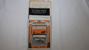
... The Kiewa Valley has been a farming district from early settlement of white people. This has continued until the present although the nature of farming has varied over the years. ...Kiewa Valley Historical Society Mount Beauty Information Centre 31 Bogong High Plains Rd Mt Beauty high-country The Kiewa Valley has been a farming district from early settlement of white people. This has continued until the present although the nature of farming has varied over the years. ...The Kiewa Valley has been a farming district from early settlement of white people. This has continued until the present although the nature of farming has varied over the years. Access to information has improved with transport and technology. The journals kept the farmers informed and up to date.These booklets and journals were one of the few sources of information during the 1950s for the isolated farmers of the Kiewa Valley. The Kiewa Hydro Electric Scheme improved both transport and technology during the scheme's construction from the 1940s. It provided the township of Mt Beauty at the upper end of the valley where shops and schools were constructed, roads were improved out of the valley and the supply of electricity for milking etc. became available. 1. 14 articles each bounded by 2 staples, and each reprinted from Dept. of Agriculture Journal on a particular topic relating to Agriculture. All black & white and c1950s. 2. 4 Journals with colored covers 3 from Victoria Dept. of Agriculture (1932, 1974 & 1975) and 1 from Sth. Australia.1. "J.H.Wallace" hand written top right corner of covers of pamphlets titled 'Diseases Affecting /Young Cattle' and 'Mastitis'. "AHW" hand written top right corner of cover of pamphlet titled ' Grading Land for Irrigation' 2. Nonefarming, agriculture, cattle, pasture, kiewa valley, department of agriculture in victoria, kiewa hydro electric scheme, -
 Wycheproof & District Historical Society Inc.
Dempsey Book, Dempsey Land Selection, 2003l
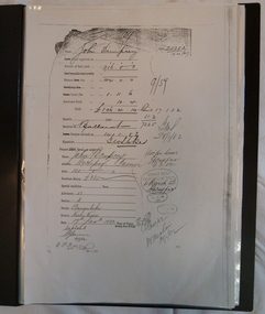
... Several official Lands Department correspondence provides evidence of Dempsey's early land acquisition at the beginning of the town's farming history and settlement from 1872 - 1882. dempsey land -act bunguluke This is an A3 sized Display book with grey spine. ...Mr Dempsey and family were the first selectors to arrive at Mt Wycheproof 1872 or early 1873. One Dempsey Land Application is dated 15-3-1873.Factual documents obtained from a Melbourne archive show settler,John Dempsey,securing land at Wycheproof. Several official Lands Department correspondence provides evidence of Dempsey's early land acquisition at the beginning of the town's farming history and settlement from 1872 - 1882. This is an A3 sized Display book with grey spine. Comprises official Lands Department Papers detailing Mr John Dempsey's Land Applications and acquisition at Wycheproof. Dated documentation is from 1872 through to 1882.Locally researched references give an overview about the Dempsey family.dempsey, land -act, bunguluke -
 Eltham District Historical Society Inc
Document, Samantha Westbrooke Pty Ltd et al, 2 Bell Street, Eltham: Cultural Heritage Significance Assessment & Heritage Guidelines for Future Use & Development, 2012
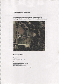
... early market gardening in Eltham with the commencement of European settlement in the late 1830s. The site for the village of Eltham was surveyed in 1851 and the Township Plan shows that the property is made up of Lots 7 and 8 which were sold at auction in June 1852 to M. O'Shea. The history of the Bell Street property is closely tied to the West family from the 1860s to 1930s; the earliest rate books for Eltham show William West farming...early market gardening in Eltham with the commencement of European settlement in the late 1830s. The site for the village of Eltham was surveyed in 1851 and the Township Plan shows that the property is made up of Lots 7 and 8 which were sold at auction in June 1852 to M. O'Shea. The history of the Bell Street property is closely tied to the West family from the 1860s to 1930s; the earliest rate books for Eltham show William West farming ...Prepared for Nillumbik Shire Council by Samantha Westbrooke Pty Ltd in association with Peter Mills PhD, Architectural Historian and Roark Muhlen-Schilte, Archaeologist. Covers history of early market gardening in Eltham with the commencement of European settlement in the late 1830s. The site for the village of Eltham was surveyed in 1851 and the Township Plan shows that the property is made up of Lots 7 and 8 which were sold at auction in June 1852 to M. O'Shea. The history of the Bell Street property is closely tied to the West family from the 1860s to 1930s; the earliest rate books for Eltham show William West farming in El;tham in 1864. In the aerly 1930s ownership of the creek side was transferred from the west family to the Fabbro family who shortly afterwards were impaced by the 1934 Diamond Creek flooding. Guido Fabbro relocated the original West home further up the hill and built a new Italianate style modern home in situ. The Fabbro family farmed the property. In 1993/4 Eltham Council acquired the creek-side market garden blocks to the south of 2 Bell Street which was recconceived in 1998 as the Barak Bushland Reserve. The Fabbro house was demolished shortly after and the lots were sold to a developer in 1994. The large steel shed now present on the 2 Bell Street property dates from soon after this sale.26 A4 pages color printcultural heritage significance assessment, peter mills, samantha westbrooke pty ltd, shire of nillumbik, 2 bell street, eltham, market gardening, west family, fabbro family, land use, barak bushland reserve, heritage assessment -
 Eltham District Historical Society Inc
Film - Video (DVD), Neisha Forbes et al, Tales of Old Nillumbik; stories of life in years gone by - Plenty Historical Society, 15 November 2005
... early settlement of Plenty. Learn about the mills situated on the Plenty River from the 1840s. Early industry such as fruit growing, poultry farming, goldmining, rabbit skinning and how they contributed to the development and employment of the area and in the case of rabbit skinning the development of other industries in Victoria during the Depression...early settlement of Plenty. Learn about the mills situated on the Plenty River from the 1840s. Early industry such as fruit growing, poultry farming, goldmining, rabbit skinning and how they contributed to the development and employment of the area and in the case of rabbit skinning the development of other industries in Victoria during the Depression Video Recording DVD converted to MP4 01:01:12 duration 264MB Tales of Old Nillumbik; stories of life in years gone by - Plenty Historical Society Film Video (DVD) Neisha Forbes Plenty Historical Society Marie Ryan ...A series of talks held October - December 2005 at the Eltham Living and Learning Centre which allowed Nillumbik Historical Societies to record the verbal history of the area with some of the well known residents of Nillumbik and surrounds Recorded and edited by Marie Ryan of Plenty Valley FM Speaker: Neisha Forbes 15th November 2005 This session covers the early settlement of Plenty. Learn about the mills situated on the Plenty River from the 1840s. Early industry such as fruit growing, poultry farming, goldmining, rabbit skinning and how they contributed to the development and employment of the area and in the case of rabbit skinning the development of other industries in Victoria during the Depressionvideo recording -
 Eltham District Historical Society Inc
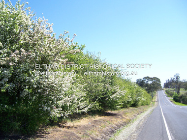
Photograph - Digital Photograph, Marguerite Marshall, Hawthorn hedges, Eltham-Yarra Glen Road, Kangaroo Ground, 3 October 2006
... farming techniques by the Kangaroo Ground population in the period following settlement and because the grid pattern of paddocks that the Hawthorn hedges define is very different to today's farm landscapes." Covered under Heritage Overlay, Nillumbik Planning Scheme. Published: Nillumbik Now and Then / Marguerite Marshall 2008; photographs Alan King with Marguerite Marshall.; p21 Hawthorn hedges bordering Kangaroo Ground’s gently rolling farmlands are important reminders of its Scottish heritage and are rare so close to Melbourne.1 As early as the 1840s newly arrived farmers from Scotland planted hawthorn hedges around their properties, to protect crops from the numerous kangaroos and wallabies. ...farming techniques by the Kangaroo Ground population in the period following settlement and because the grid pattern of paddocks that the Hawthorn hedges define is very different to today's farm landscapes." Covered under Heritage Overlay, Nillumbik Planning Scheme. Published: Nillumbik Now and Then / Marguerite Marshall 2008; photographs Alan King with Marguerite Marshall.; p21 Hawthorn hedges bordering Kangaroo Ground’s gently rolling farmlands are important reminders of its Scottish heritage and are rare so close to Melbourne.1 As early as the 1840s newly arrived farmers from Scotland planted hawthorn hedges around their properties, to protect crops from the numerous kangaroos and wallabies. ...Hawthorn hedges are important reminders of Kangaroo Ground's Scottish heritage. They are Registered on the Victorian Heritage Register. They are "historically significant because the planting of hawthorn hedges reflects the adoption of Eurorpean farming techniques by the Kangaroo Ground population in the period following settlement and because the grid pattern of paddocks that the Hawthorn hedges define is very different to today's farm landscapes." Covered under Heritage Overlay, Nillumbik Planning Scheme. Published: Nillumbik Now and Then / Marguerite Marshall 2008; photographs Alan King with Marguerite Marshall.; p21 Hawthorn hedges bordering Kangaroo Ground’s gently rolling farmlands are important reminders of its Scottish heritage and are rare so close to Melbourne.1 As early as the 1840s newly arrived farmers from Scotland planted hawthorn hedges around their properties, to protect crops from the numerous kangaroos and wallabies. Many of these hedges survive today. These farmers had the good fortune to settle some of the most fertile land available for cropping in the Colony of Victoria. At that time the black volcanic soil could sustain an amazing two crops a year. By the mid 1850s, 500 acres (202ha) of wheat were growing in Kangaroo Ground. But the crops were threatened by kangaroos, which were so plentiful, that Surveyor-General, Robert Hoddle, named the district Kangaroo Ground in 1838. As post-and-rail fences proved inadequate barriers for the bounding kangaroos, the Scots planted hawthorn hedgerows as they had done in Scotland. Some also used the hedges to net birds, presumably for the table. Interestingly the farmers in the bordering townships of Panton Hill and Christmas Hills, did not plant hawthorn hedges around their properties. Perhaps it was because by the time they settled in the 1860s and 1870s most of the wildlife had been gunned down by residents.2 The canny Scots planted the hedges on public land outside their own farms, as the hedgerows could spread to about five yards (five m) in width. With this impenetrable barrier Kangaroo Ground’s industrious farmers flourished to gain the economic power that saw the Shire of Eltham governed from Kangaroo Ground for 79 years (1858-1937). The Scots jealously guarded their land, so hard to get in Scotland. That is why they refused to release any of it ‘for local roads to follow easier grades as was the case in surrounding districts where roads generally followed ridgelines or streams’.3 Instead the roads were built in accordance with the magnetic bearings of their first survey in 1847 whether that suited the steep topography or not. This could force traffic to diverge when wet through Greensborough and Diamond Creek. Until 1921, the Eltham-Yarra Glen Road beside Wellers Restaurant, ‘dipped down into the upper reaches of Stony Creek’.4 Later some corners were compulsorily cut for the increasing motor traffic. As late as the 1960s, corners were cut to form sweeping curves above and alongside the Kangaroo Ground Cemetery and opposite the Emergency Operations Centre. In the latter case, the farmers – understanding their hedgerows as important heritage – insisted upon their reinstatement to conform to the altered road alignment. Kangaroo Ground’s ancient manna gums also point to the district’s history and to that of the hedgerows. The Aboriginal people had transformed the original forests into grasslands with the fires they lit to attract kangaroos, (which the Scots were to exclude by planting hedgerows). But the Wurundjeri hunters left the gums (Eucalyptus vimminalis cygnetensis), on the grasslands as ‘stalking trees’ to hunt kangaroos. The hawthorn hedges in Kangaroo Ground were neglected for around 60 years from about the middle of the 20th century. Bushfires had created gaps and the hedgerows were not trimmed. Then in late 2005, local historian Mick Woiwod, formed a group to lobby the Nillumbik Shire to restore the hedges, which could last for many centuries. Some hedges in parts of Britain date back to AD 800.5 Although the original Scottish farmers have gone, the hedges are a reminder of when they flourished in the district, which has changed little in 150 years.This collection of almost 130 photos about places and people within the Shire of Nillumbik, an urban and rural municipality in Melbourne's north, contributes to an understanding of the history of the Shire. Published in 2008 immediately prior to the Black Saturday bushfires of February 7, 2009, it documents sites that were impacted, and in some cases destroyed by the fires. It includes photographs taken especially for the publication, creating a unique time capsule representing the Shire in the early 21st century. It remains the most recent comprehenesive publication devoted to the Shire's history connecting local residents to the past. nillumbik now and then (marshall-king) collection, eltham-yarra glen road, hawthorn hedgerow, kangaroo ground -
 Phillip Island and District Historical Society Inc.
Photograph, Bryant West
... early settlement...black & white photograph...farming...Phillip Island and District Historical Society Inc. phillip-island-and-the-bass-coast One of a collection of over 400 photographs in an album commenced in 1960 and presented to the Phillip Island & Westernport Historical Society by the Shire of Phillip Island local history photography photographs painting early settlement black & white photograph farming settlement mchaffie john jenner bryant west Hand written inscription by W. ...One of a collection of over 400 photographs in an album commenced in 1960 and presented to the Phillip Island & Westernport Historical Society by the Shire of Phillip IslandPhotograph of a Sketch of Head Station of Messrs. W & W J McHaffie by W. & E. Liardet. Copy of water colour by Victoria's earliest artist late 1840's.Hand written inscription by W. J. McHaffie - "Sketch of Head Station of Mssrs. W & J.M. McHaffie of Phillip Island by W.F.E. Liardet."local history, photography, photographs, painting, early settlement, black & white photograph, farming, settlement, mchaffie, john jenner, bryant west -
 Flagstaff Hill Maritime Museum and Village
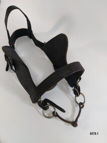
Equipment - Show Harness, R. Mitchell, Saddler, Early to mid-20th century
... This horse harness is a significant example of the equipment that was needed wherever heavy horses were being used - particularly in the early years of Victoria's settlement by white settlers. Harnesses such as this example were used with stage coaches, drays, farming equipment, delivery carts and personal transportation. ...The early settlers of Victoria depended on horse drawn vehicles to farm, make roads and railways, deliver produce and transport people. Horse harnesses were an important requisite for all drivers and could be found wherever there were working horses. Horse Harnesses have played an essential role in different cultures throughout history. Simple, utilitarian horse harnesses made of leather straps and iron rings were being used in early China before AD 500 as well as ancient Greece and Rome, allowing horses to pull chariots and ploughs. The Greeks and Romans were the first to use a "horse collar" which distributed the weight of the harness evenly across the horse's chest rather than relying on a "throat harness" that could damage a horse's throat or choke them. During the medieval period, European horse harnesses became more elaborate and decorative. Variations of different horse harnesses were also found in Native American and Middle Eastern cultures. Horse Harnesses usually have four basic components which include - 1. Communication - the bridle, bit and reins allows the driver to communicate instructions and commands to the horse, guiding its movement and direction. 2. Draft - the collar, hame straps, hames, traces and chains enables the horse to draw and pull the load efficiently by distributing the weight and transferring the pulling force to the vehicle. 3. Stopping - the breeching band, pole straps and breast strap helps to control or stabilise the horse and vehicle when moving downhill or stopping. 4. Support - the back pad, backband, belly band and back saddle keep the harness in the correct position and proper alignment. This show harness was used by Mr. Andy Bourke when showing his Clydesdales at shows or demonstrations. Although a more modern example with decorative embellishments, it still has many essential components traditionally found in an everyday working horse harness. The original purpose of the "housen" for example, was to run rain or drizzle off the horse's neck when they had to work in wet conditions - it was laid flat for this purpose on the top of the collar. Nowadays it is purely for show and is often used to advertise a business or stud. Horse brasses and fly terrets were fastened to various parts of a horse's harness. In the early days they probably began as amulets to ward off evil and to bring good luck and continued to be used as a festive decoration. The heyday of horse brasses was between the years 1851 and 1900. Horse brasses are fastened to various parts of the harness with many of their designs being symbolic. The ornamentation on this harness (although not authentic horse brasses) are based on the horse brasses that were popular in the 19th century. This horse harness is a significant example of the equipment that was needed wherever heavy horses were being used - particularly in the early years of Victoria's settlement by white settlers. Harnesses such as this example were used with stage coaches, drays, farming equipment, delivery carts and personal transportation.A leather and metal horse harness used when showing a Clydesdale (or other breed of heavy horse). It is made up of a number of components. 1. Decorative leather cart saddle with two large cloth pads underneath (which have a scalloped leather and stud border), a raised leather pommel and a silver and red coloured metal back strap holder across the top. It has two symmetrical sets of ornamentation (silver hearts and circles) in the front and a wide strap or girth (with a maker's stamp reading "R. Mitchell Saddler") and buckle which attaches the saddle to the horse. 2. Pair of steel hames which are gently curved (to fit on a horse collar) and are topped with steel knobs. They have several steel rings and lugs (to hold straps and chains) and a "Made in England Warranted Steel" stamp. 3. Breeching harness which consists of a number of leather straps, chains and metal rings including a wide padded leather strap with a scalloped edge that sits on the back of the horse and a thick leather strap that goes around the hind quarters of a horse which is joined to the back strap with four shorter vertical straps and buckles. These straps feature silver and red patent leather trim and silver heart shaped ornamentation. The strap also features the maker's stamp of "R. Mitchell". 4. Decorative leather bridle with blinkers featuring the same silver and red patent leather trim on the cheek piece, brow band and throatlatch. It has a stainless steel "Liverpool Driving Bit" with a curb chain, a variety of decorative silver ornaments (rosettes, diamonds plus a heart and two circles) on each end of the forehead band, dropper and strap as well as a silver metal bell (sometimes known as a "fly terret" or "swinger") that sits on the headpiece of the bridle. 5. Leather "violin shaped" dropper (or hanger) with two silver rosette shaped ornaments and a stainless steel clip on the top 6. Stainless steel "Liverpool Driving Bit" with a straight mouthpiece which is ribbed on one side. It has three rein spots (spaces) and a curb chain. 7. Leather arch shaped "Housen" covered in black and red patent leather and decorated with silver studs (some spelling out F H) and bordered with a red fringe. It has a leather strap at the back and two leather loops on the front. 8. Leather padded backband (Australian style "Stallion Draught Roller") decorated with two groups of nine metal "horse brasses" or harness ornaments displaying horseshoe, starburst and horse head designs on blue, red and white striped webbing. The backband has three notched straps at each end, a buckle near the centre and the initial B stamped in two places underneath. 9. Bellyband made of leather and red, white and blue striped webbing. It has a set of three buckles at each end (which correspond with the notched straps of the backband). 10. Wide, thick leather strap which has a buckle and notches at each end. It also has the maker's stamp of "R. Mitchell Saddler". 11.One pair of long leather traces - each with a buckle and notched loop at one end, decorated with a small silver diamond shaped harness ornament. 12. Length of stainless steel heavy duty chain with two swivel connectors.Saddle - "R.MITCHELL / SADDLER" Hames - "MADE IN ENGLAND / WARRANTED / STEEL" "MADE IN ENGLAND / WARRANTED / unclear" Breeching Straps - "R. MITCHELL / MAKER / R. MITCHELL MAKER" Housen - "F H" Backband "B / B' Wide leather strap - "R. MITCHELL / SADDLER"flagstaff hill maritime museum and village, warrnambool, great ocean road, shipwreck coast, harness, horse harness, show harness, clydesdale horses, andy bourke, horse drawn cart, housen, bridle, hames, breeching straps, dropper, bit, liverpool bit, backband, harness ornamentation, bellyband, back saddle, fly terret -
 Flagstaff Hill Maritime Museum and Village
Equipment - Horse Harness, Glenn's Leather Goods, Early to mid-20th century
... This horse harness is a significant example of the equipment that was needed wherever horses were being used - particularly in the early years of Victoria's settlement by white settlers. Harnesses such as this example were used with drays, farming equipment, delivery carts and personal transportation. ...The early settlers of Victoria depended on horse drawn vehicles to farm, make roads and railways, deliver produce and transport people. Horse harnesses were an important requisite for all drivers and could be found wherever there were working horses. Horse Harnesses have played an essential role in different cultures throughout history. Simple, utilitarian horse harnesses made of leather straps and iron rings were being used in early China before AD 500 as well as ancient Greece and Rome allowing horses to pull chariots and ploughs. The Greeks and Romans were the first to use a "horse collar" which distributed the weight of the harness evenly across the horse's chest rather than relying on a "throat harness" that could damage a horse's throat or choke them. During the medieval period, European horse harnesses became more elaborate and decorative. Variations of different horse harnesses were also found in Native American and Middle Eastern cultures. Horse Harnesses usually have four basic components which include - 1. Communication - the bridle, bit and reins allows the driver to communicate instructions and commands to the horse, guiding its movement and direction. 2. Draft - the collar, hame straps, hames, traces and chains enables the horse to draw and pull the load efficiently by distributing the weight and transferring the pulling force to the vehicle. 3. Stopping - the breeching band, pole straps and breast strap helps to control or stabilise the horse and vehicle when moving downhill or stopping. 4. Support - the back pad, backband, belly band and back saddle keep the harness in the correct position and proper alignment. This dray harness is a plain, basic harness and reflects its working class origins. It was used by Mr. Oswald (Jack) Bourke with his horse and dray to firstly deliver drygoods from Sunbury to Melbourne in the 1930's and later (through the 1940's and 1950's up to 1961) when he worked on the garbage round for the Springvale City Council. This horse harness is a significant example of the equipment that was needed wherever horses were being used - particularly in the early years of Victoria's settlement by white settlers. Harnesses such as this example were used with drays, farming equipment, delivery carts and personal transportation.A leather and metal horse harness used with a horse and dray circa 1930's to the early 1960's. It is made up of a number of components. 1. A leather bridle with metal buckles and rings, blinkers and a metal single jointed, snaffle bit that has the initials M B stamped onto the leather. 2. A leather bridle with metal buckles and rings and a metal "straight bar" Eggbut snaffle bit. It has an elongated X design (with 4 dots) stamped onto the leather strap holders near each buckle. 3. A blue and white vinyl halter with one leather patched strap. The nose band and a chin strap are covered with woollen padding. 4. A pair of leather shaft protectors. They have lacing holes along each edge and a repeating design of small shapes (flowers, wings, crosses and arrowheads) which run along the front of each protector. 5. A leather strap with a stainless steel chain and catch and a maker's mark for "Glenn's Leather Goods, Pearcedale Victoria" stamped onto the end. 6. A wide leather strap covered with a webbing sleeve. It has two large metal rings and each end and one ring has a rope attached. 7. A leather strap comprised of three separate sections (two shorter and one longer) joined with two metal rings. The longer section has notches along its length and the shorter section at the other end has a buckle. It also had a maker's mark stamped on it but the mark is very worn and the writing is difficult to read. 8. An adjustable leather horse collar with two buckles and straps at the top opening and two "B's" stamped into the leather. The top of the collar is made from treated leather pieces stitched together and the underneath of the collar is untreated leather. It has a padded indentation running all the way around the collar for the hames to sit in. 9. Two pairs of long leather traces - each having a buckle and notched section at one end and each one is made with three lengths of leather spliced together. 10. A leather strap (with one spliced join) belonging to a horse harness with two shorter straps (each ending with a metal clip) attached to a steel D ring at one end. 11. Three assorted short leather straps - the top one has clips at each end and a buckle (for adjusting the length) in the centre, the middle strap has notches and a buckle and the bottom strap is white with notches and a buckle.Bridle with blinkers - "M B" Bridle - design showing an elongated X with a dot in each section stamped onto strap holder Shaft Protectors - stamped design of flowers, wings, crosses and arrowheads Strap with chain - "Glenn's leather goods / Pearcedale / Victoria" Leather Strap (with two metal rings) - Maker's stamp - "name indecipherable / SADDLER / ...OURNE" Collar - "B / B" Leather strap - flagstaff hill maritime museum and village, warrnambool, great ocean road, sunbury, springvale, dray, delivery dray, harness, horse harness, horse drawn vehicles, working horse, oswald (jack) bourke, bridle, horse collar, hames, shaft protectors -
 City of Moorabbin Historical Society (Operating the Box Cottage Museum)
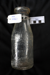
Manufactured Glass, milk bottle 'Black Rock Dairy', 20thC
... Dairy farming was established early in the settlement of the Brighton / Moorabbin area following the Dendy's Special Survey 1841 and subsequent land sales c1850. ...Alfred R Varcoe was a dairyman with stables, cart shed and his house in Eliza Street, Black Rock, Victoria. Dairy farming was established early in the settlement of the Brighton / Moorabbin area following the Dendy's Special Survey 1841 and subsequent land sales c1850. The produce was taken to feed the population of Melbourne and local residents.A clear glass ,1 pint , milk bottle used by Black Rock Dairy, MelbourneTHIS BOTTLE CONTAINS/ MILK / BOTTLED FOR SALE BY / BLACK ROCK MODEL / DAIRY / BLACK ROCK / BOTTLE IS THE PROPERTY OF THE ABOVE / IT IS OWNED AND CANNOT BE LEGALLY USED BY OTHERS/ ONE IMPERIAL PINT on base 440market gardeners, early settlers, farmers, dairies, milk production, moorabbin shire, moorabbin, cheltenham, black rock, brighton, dairy farmers, bottles, glass manufacture, varcoe alfred r; black rock dairy, dairy farmer, dairy products sales and deliveries, -
 Orbost & District Historical Society
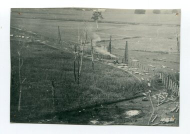
black and white photograph, 1916
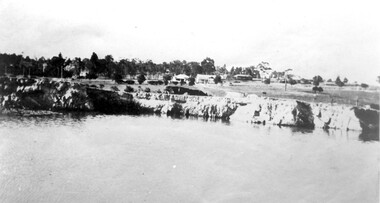
... early twentieth-century interest in American-style 'Developmental Railways', designed to open remote areas to closer settlement, even if that meant running at a loss. The line was closed in August 1987. (information from Victorian Heritage Database) This item is associated with the history of the Orbost-Bairnsdale railway line and therefore reflects the role that the rail line played in the social and economic history of Orbost. orbost-railway east-gippsland-railway viaduct-orbost transport railway A black / white photograph of the farming flats at Orbost during the construction of the East Gippsland railway. black and white photograph ...This photograph shows the pile drivers at work in the construction of the viaduct across the Snowy River flats. The Snowy River Floodplain Railway Bridges, two sequential and exceptionally long and low timber railway bridges on the Snowy River floodplain just west of Orbost, were built in 1916, and provided the original terminus point for the Bairnsdale-Orbost railway. The bridges are 770 metres and 183 metres long respectively. The shorter bridge is of uniformly 4.57 metre timber-beam construction, and has a sweeping curve in its deck. The longer bridge has a combination of 4.57 metre and 6.1 metrespans, and two 3.66 metre spans. The bridges are constructed from 'Southern Mahogany', Eucalyptus Botryoides, which grew along the coast east of Bairnsdale. The Snowy floodplain bridges were initially built in the context of an early twentieth-century interest in American-style 'Developmental Railways', designed to open remote areas to closer settlement, even if that meant running at a loss. The line was closed in August 1987. (information from Victorian Heritage Database)This item is associated with the history of the Orbost-Bairnsdale railway line and therefore reflects the role that the rail line played in the social and economic history of Orbost.A black / white photograph of the farming flats at Orbost during the construction of the East Gippsland railway.orbost-railway east-gippsland-railway viaduct-orbost transport railway -
 Flagstaff Hill Maritime Museum and Village
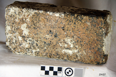
Ceramic - Clay Brick, ca 1837
... farming implements, and six whaleboats with associated whaling gear, and house bricks for the Hentys' settlement in Portland. One account states that when the CHILDREN “put out from port, it was light and badly ballasted”. The vessel immediately encountered four days of hurricane force storms, eventually clearing on the early...farming implements, and six whaleboats with associated whaling gear, and house bricks for the Hentys' settlement in Portland. One account states that when the CHILDREN “put out from port, it was light and badly ballasted”. The vessel immediately encountered four days of hurricane force storms, eventually clearing on the early ...According to Lloyds Shipping Register 1837-1839, the CHILDREN was built in 1825 at Liverpool and operated by owners Gordon & Co, of London. London registered number 123/1837. James Henty then bought the vessel in 1837 as a three-masted barque of 254 tons, with a hull of “part pitch pine, felt sheathed” and “coppered 1837”. Launceston registered number 6/1837. In 1838, the CHILDREN, under her master Captain H. Browne, completed a successful round trip from Launceston to London carrying wool and whale oil loaded in Portland, returning in late November of that year carrying a general cargo including the house bricks. On the 11th January 1839, the CHILDREN sailed from Launceston for Adelaide, with 24 passengers, 14 crew, and an awkward mixed cargo, including 1500 sheep, 8 bullocks, 7 horses, farming implements, and six whaleboats with associated whaling gear, and house bricks for the Hentys' settlement in Portland. One account states that when the CHILDREN “put out from port, it was light and badly ballasted”. The vessel immediately encountered four days of hurricane force storms, eventually clearing on the early morning of the 14th to “west force 10”, but too late to take accurate measurements of the sun or stars to establish their position relative to the coast. The CHILDREN collided with a limestone stack at the entrance of what is now called Childers Cove, and the seas smashed it into pieces within half an hour. All the cargo and 16 lives were lost, including 9 children. The Hentys contributed £150 towards a fund for the 22 survivors at a memorial service held in Launceston later that year. It was a major financial setback for the Henrys, but one from which they recovered. In a submission to the Governor of New South Wales dated 24 March 1840, the Henty’s summarised their work over the previous six years of settlement: “Six stations have been occupied, one at Portland Bay…three at the open country about 60 miles inland called ‘Merino Downs’…They have erected two houses at Portland Bay and two others at Merino Downs”. The London house bricks recovered from the Children's wreck are significant as part of the cargo of the early 19th-century barque. The bricks were intended for the owner of the Children, the Henty family, for their Portland settlement. The 1839 wreck and recovered artefacts are examples of the construction methods and materials used in that era and can be used to study the evolution of shipbuilding methods and principles. The wreck of the Children is of state significance as one of colonial Victoria’s earliest and most significant maritime disasters, and one of the first vessels lost in the Western District. This is recognised by its inclusion on the Victorian Heritage Register, VHR No. S116. Little is left on the seabed to mark the tragedy, apart from some of the house bricks intended for the Henty settlement. Clay brick: house brick from London, with some with white marine encrustation, recovered from the wreck of the ship CHILDREN. The brick is an oblong shape and is constructed of a coarse-grained conglomerate. flagstaff hill, flagstaff hill maritime museum and village, warrnambool, maritime museum, maritime village, great ocean road, shipwreck coast, shipwreck artefact, children, barque, three-masted, liverpool, childer’s cove, port campbell, 1839 shipwreck, 1939 wreck, james henty and co, henty brothers, captain h. browne, first mate t. gay, second mate w. wentworth, portland, portland bay, 1939, bricks, london house bricks, clay bricks -
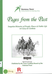 Narre Warren and District Family History Group
Book, National Trust of Australia (Victoria). Casey-Cardinia Branch, Pages from the Past. Snapshot Histories of People, Places & Public Life in Casey & Cardinia, 2011
... Contents include: Richard Gavin Gardiner Casey [Edrington]; The Police Paddocks and the Native Police Corps; The changing face of Berwick township; Coaches, tolls and local councils; Berwick Mechanics Institute and Free Library; Berwick Primary School [No. 40] and Berwick Grammar School; A century of quarrying in Berwick; The German settlement of Harkaway; Emerald’s first State School No. 2110 (1879-1909); The railway to Gippsland; Early sawmilling in West Gippsland; Tooradin and the coastal villages; Some notable early residents and their homes; The draining of the Koo-Wee-Rup swamp; Guest houses at Upper Beaconsfield; Ada Armytage of Holm Park; The soldiers of early Berwick; Memorials, commemorations and avenues of honour; Bush nursing hospitals; The Melbourne Hunt Club [The "Kennels" at Cranbourne]; Growing up in Berwick in the 1930s & 1940s; Growing up in Beaconsfield in the 1930s and 1940s; Casey Airfield; The history of Maryknoll [Catholic farming community]; The filming of “On the beach”; Memories of Ash Wednesday; Maps of the Casey-Cardinia area. ...Contents include: Richard Gavin Gardiner Casey [Edrington]; The Police Paddocks and the Native Police Corps; The changing face of Berwick township; Coaches, tolls and local councils; Berwick Mechanics Institute and Free Library; Berwick Primary School [No. 40] and Berwick Grammar School; A century of quarrying in Berwick; The German settlement of Harkaway; Emerald’s first State School No. 2110 (1879-1909); The railway to Gippsland; Early sawmilling in West Gippsland; Tooradin and the coastal villages; Some notable early residents and their homes; The draining of the Koo-Wee-Rup swamp; Guest houses at Upper Beaconsfield; Ada Armytage of Holm Park; The soldiers of early Berwick; Memorials, commemorations and avenues of honour; Bush nursing hospitals; The Melbourne Hunt Club [The "Kennels" at Cranbourne]; Growing up in Berwick in the 1930s & 1940s; Growing up in Beaconsfield in the 1930s and 1940s; Casey Airfield; The history of Maryknoll [Catholic farming community]; The filming of “On the beach”; Memories of Ash Wednesday; Maps of the Casey-Cardinia area. Notable people : William Lyall and "Harewood'; William Clarke and "Springfield'; Sydney Webb and "Holly Green"; Carl Axel Nobelius; Edwin Flack and "Burnbank"; Carlo Catani;. Includes illustrations, portraits, photographs, maps and bibliography.106 p. : ill., portraits, map, bib., pbk ; 30 cmnon-fictionContents include: Richard Gavin Gardiner Casey [Edrington]; The Police Paddocks and the Native Police Corps; The changing face of Berwick township; Coaches, tolls and local councils; Berwick Mechanics Institute and Free Library; Berwick Primary School [No. 40] and Berwick Grammar School; A century of quarrying in Berwick; The German settlement of Harkaway; Emerald’s first State School No. 2110 (1879-1909); The railway to Gippsland; Early sawmilling in West Gippsland; Tooradin and the coastal villages; Some notable early residents and their homes; The draining of the Koo-Wee-Rup swamp; Guest houses at Upper Beaconsfield; Ada Armytage of Holm Park; The soldiers of early Berwick; Memorials, commemorations and avenues of honour; Bush nursing hospitals; The Melbourne Hunt Club [The "Kennels" at Cranbourne]; Growing up in Berwick in the 1930s & 1940s; Growing up in Beaconsfield in the 1930s and 1940s; Casey Airfield; The history of Maryknoll [Catholic farming community]; The filming of “On the beach”; Memories of Ash Wednesday; Maps of the Casey-Cardinia area. Notable people : William Lyall and "Harewood'; William Clarke and "Springfield'; Sydney Webb and "Holly Green"; Carl Axel Nobelius; Edwin Flack and "Burnbank"; Carlo Catani;. Includes illustrations, portraits, photographs, maps and bibliography. city of casey, cardinia shire (vic.) -
 Sunshine and District Historical Society Incorporated
Photograph - St. Albans Primary School Photographs
... early farming families shortly after the suburb itself was created by Alfred Padley and the Cosmopolitan Land & Banking Co. around the railway line. Local families needed a permanent school to replace informal or church-based teaching arrangements and this school was built. St. Albans grew dramatically after WWII due to migrant settlement...early farming families shortly after the suburb itself was created by Alfred Padley and the Cosmopolitan Land & Banking Co. around the railway line. Local families needed a permanent school to replace informal or church-based teaching arrangements and this school was built. St. Albans grew dramatically after WWII due to migrant settlement ...The St. Albans State School, now the St. Albans Primary School opened in 1889 and is one of the oldest continuously operating schools in Melbourne’s western suburbs. The school was founded by early farming families shortly after the suburb itself was created by Alfred Padley and the Cosmopolitan Land & Banking Co. around the railway line. Local families needed a permanent school to replace informal or church-based teaching arrangements and this school was built. St. Albans grew dramatically after WWII due to migrant settlement and with industrial expansion in Sunshine, Tottenham, and Braybrook. The school was expanded with additional classrooms, specialist rooms (art, library, music) and larger playgrounds and assembly areas. By the 1960s–70s, the state School was a major multicultural school serving a rapidly growing suburb. For more than a century, the school has been central to migrant education, local civic life, community events and fetes The school has tight partnerships with the St. Albans High School and other local institutions. The school remains one of the longest running institutions in the district. St. Albans Primary School received its current name in 1970, when the Victorian Education Department changed all “State School” names to “Primary School.” St. Albans Primary School continues to operate on its original site and remains a key part of the educational landscape of Melbourne’s western suburbs.st. albans primary school, west esplanade, st. albans, st. albans state school -
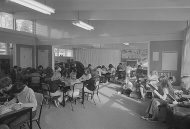
 Sunshine and District Historical Society Incorporated
Photograph - St. Albans State School Photographs
... early farming families shortly after the suburb itself was created by Alfred Padley and the Cosmopolitan Land & Banking Co. around the railway line. Local families needed a permanent school to replace informal or church-based teaching arrangements and this school was built. St. Albans grew dramatically after WWII due to migrant settlement...early farming families shortly after the suburb itself was created by Alfred Padley and the Cosmopolitan Land & Banking Co. around the railway line. Local families needed a permanent school to replace informal or church-based teaching arrangements and this school was built. St. Albans grew dramatically after WWII due to migrant settlement ...The St. Albans State School, now the St. Albans Primary School opened in 1889 and is one of the oldest continuously operating schools in Melbourne’s western suburbs. The school was founded by early farming families shortly after the suburb itself was created by Alfred Padley and the Cosmopolitan Land & Banking Co. around the railway line. Local families needed a permanent school to replace informal or church-based teaching arrangements and this school was built. St. Albans grew dramatically after WWII due to migrant settlement and with industrial expansion in Sunshine, Tottenham, and Braybrook. The school was expanded with additional classrooms, specialist rooms (art, library, music) and larger playgrounds and assembly areas. By the 1960s–70s, the state School was a major multicultural school serving a rapidly growing suburb. For more than a century, the school has been central to migrant education, local civic life, community events and fetes The school has tight partnerships with the St. Albans High School and other local institutions. The school remains one of the longest running institutions in the district. St. Albans Primary School received its current name in 1970, when the Victorian Education Department changed all “State School” names to “Primary School.” St. Albans Primary School continues to operate on its original site and remains a key part of the educational landscape of Melbourne’s western suburbs.These photographs show how multicultural the school had become after the post WW2 migrant boom.st. albans primary school, west esplanade, st. albans, st. albans state school -
 Broadmeadows Historical Society & Museum
Photograph - Aerial Photograph
... Key historical milestones include: Early Settlement: Originally inhabited by the Wurundjeri people of the Kulin Nation. European Settlement: Began in the mid-1800s, primarily for farming and grazing. ...Key historical milestones include: Early Settlement: Originally inhabited by the Wurundjeri people of the Kulin Nation. European Settlement: Began in the mid-1800s, primarily for farming and grazing. ...Craigieburn is a rapidly growing suburb located approximately 25 km north of Melbourne’s CBD. Historically, it was a rural area with agricultural roots, but since the late 20th century, it has undergone significant urban development. The transformation accelerated in the 1990s and 2000s, with large-scale residential subdivisions, infrastructure projects, and commercial developments reshaping the landscape. Key historical milestones include: Early Settlement: Originally inhabited by the Wurundjeri people of the Kulin Nation. European Settlement: Began in the mid-1800s, primarily for farming and grazing. Urban Expansion: Post-1970s, Craigieburn saw increasing suburban development, especially after the extension of rail and road infrastructure. Recent Growth: From the 2000s onward, Craigieburn became one of Melbourne’s fastest-growing suburbs, with new estates, schools, and shopping centres.This large colour aerial photograph of Craigieburn holds significant value as a visual record of the suburb’s transformation from a semi-rural landscape to a dynamic urban centre in Melbourne’s northern growth corridor. Captured during a period of rapid development, the image documents the spatial evolution of Craigieburn, including residential expansion, infrastructure projects, and the integration of green spaces and commercial zones. The photograph is historically significant as it reflects the broader patterns of post-2000 suburban growth in Victoria, driven by population pressures, housing demand, and strategic planning initiatives. It provides insight into land use changes, transport connectivity (notably the Hume Highway and Craigieburn railway line), and the emergence of community hubs such as Craigieburn Central. From a cultural heritage perspective, the image contributes to understanding the lived environment of diverse communities who have settled in Craigieburn, including its role in accommodating Melbourne’s multicultural population. It also serves as a reference point for future urban planning, environmental monitoring, and historical comparison. The photograph is an important archival asset for researchers, planners, and local historians, offering a detailed snapshot of a pivotal moment in Craigieburn’s development trajectory.Colour aerial photograph of Craigieburnaerial photograph, craigieburn -
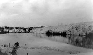 Surrey Hills Historical Society Collection
Photograph, Grovedale Road Quarry in the 1920s - looking south, c1920
... This documents the landscape prior to close settlement and is material to early building and farming in the Surrey Hills area. quarries grovedale road james street clay quarries farming, kate conlon, kate maling, john butler maling Ancyra Black and white photo of the quarry between Grovedale Road and James Street taken in the 1920s and looking south. ...The quarry was part of John Butler Maling's property. He was one of the original settlers of the area and farmed the area between Weybridge Street and Whitehorse Road. Clay was quarried from part of this area and used to make the bricks used in the construction of his home, known as 'Ancyra'. This is still extant at the corner of Weybridge and James Streets. Maling grazed cows and used the quarry as a water source. He was the uncle of John Butler Maling, Mayor of Camberwell. He was married to Kate Conlon in 1882. They had 3 children: Silas Young, Alick and Zillah. Maling was born in c1829 in Shepreth, Cambridgeshire; he died in Surrey Hills on 9 October 1912 and is buried in Box Hill Cemetery - CE-*-0586. Mrs Kate Maling (born c1859 in Co Meath, Ireland) died at the property on 8 March 1921. She is buried in Brighton General Cemetery. Probate was valued at over 10,000 pounds and included other properties in Sandringham, Hawthorn and Macedon. At the time of her death the Surrey Hills property was described as being 23 acres with 2 brick houses, 1 cow, 2 heifers and 40 fowls or chickens. The property was subdivided after her death. The property was subdivided into 110 house blocks in c1923 - see Maling's Estate subdivision flyer on the State Library of Victoria's website. This shows that the Grovedale Park site had been acquired by Camberwell Council by this time. An attached newspaper clipping documents prices realised for a cross-section of blocks. The MMBW map of 1925, also on the SLV website, shows the outline of the clayhole / quarry. The quarry was filled in after several drownings or near drownings and the land is now occupied by a park and playground, known as Grovedale Road Park, maintained by the City of Boroondara. Beckett Park is sited on horizon to the left beyond the trees. This documents the landscape prior to close settlement and is material to early building and farming in the Surrey Hills area.Black and white photo of the quarry between Grovedale Road and James Street taken in the 1920s and looking south. In the foreground is an area of water with reeds in the LH corner. Beyond on the high banks there are single storey houses in the background and (?) some light poles. An object that looks like a tank on posts is in a cutting on the far bank.quarries, grovedale road, james street, clay quarries, farming, kate conlon, kate maling, john butler maling, ancyra -
 Surrey Hills Historical Society Collection
Photograph, Grovedale Road Quarry in the 1920s - looking north, c1920
... This documents the landscape prior to close settlement and is material to early building and farming in the Surrey Hills area. quarries grovedale road james street surrey hills balwyn clay quarries Ancyra, kate conlon, kate maling, john butler maling, farming Black and white photo of the quarry between Grovedale Road and James Street taken in the 1920s and looking north. ...The quarry was part of John Butler Maling's property. He was one of the original settlers of the area and farmed the area between Weybridge Street and Whitehorse Road. Clay was quarried from part of this area and used to make the bricks used in the construction of his home, known as 'Ancyra'. This is still extant at the corner of Weybridge and James Streets. Maling grazed cows and used the quarry as a water source. He was the uncle of John Butler Maling, Mayor of Camberwell. He was married to Kate Conlon in 1882. They had 3 children: Silas Young, Alick and Zillah. Maling was born in c1829 in Shepreth, Cambridgeshire; he died in Surrey Hills on 9 October 1912 and is buried in Box Hill Cemetery - CE-*-0586. Mrs Kate Maling (born c1859 in Co Meath, Ireland) died at the property on 8 March 1921. She is buried in Brighton General Cemetery. Probate was valued at over 10,000 pounds and included other properties in Sandringham, Hawthorn and Macedon. At the time of her death the Surrey Hills property was described as being 23 cres with 2 brick houses, 1 cow, 2 heifers and 40 fowls or chickens. The property was subdivided after her death. The quarry was filled in after several drownings or near drownings and the land is now occupied by a park and playground maintained by the City of Boroondara. Beckett Park is sited on horizon to the left beyond the trees. This documents the landscape prior to close settlement and is material to early building and farming in the Surrey Hills area.Black and white photo of the quarry between Grovedale Road and James Street taken in the 1920s and looking north. In the foreground is an area of water with high banks dividing the horizontal centre. Beyond are paddocks and trees behind which is a row of at least 3 single-storey houses. Light poles can be seen along a distant street. There are many mature trees in the background. The houses and trees are positioned along Whitehorse Road in the vicinity of Westminster Street. Shadows indicate the photo was taken in early morning or evening.quarries, grovedale road, james street, surrey hills, balwyn, clay quarries, ancyra, kate conlon, kate maling, john butler maling, farming -
 Wonthaggi & District Historical Society
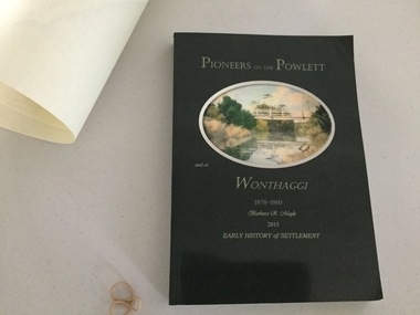
Book and Map, Barbara Moyle, Pioneers on tthe Powlett and at Wonthaggi 1878-1910, 2015
... Significant land marks, buildings and photographs are included. farming pioneers of wonthaggi and district wonthaggi families Pioneers on the Powlett and at Wonthaggi 1878-1910 Barbara R Moyle 2015 Early History of Settlement Map - Parish names, significant sites Dark green cover with oval artists impression of Powlett river and bridge Associated map which covers the parishes plus key places of interestl Pioneers on tthe Powlett and at Wonthaggi 1878-1910 Book and Map Barbara Moyle ...Book - families social histories, maps, photograps Map - block numbers town names physical / geographical featuresFarming and social history of pioneers of the Powlett River are prior to the establishment of the State Coal Mine at Wonthaggi. Significant land marks, buildings and photographs are included. Dark green cover with oval artists impression of Powlett river and bridge Associated map which covers the parishes plus key places of interestlPioneers on the Powlett and at Wonthaggi 1878-1910 Barbara R Moyle 2015 Early History of Settlement Map - Parish names, significant sitesfarming, pioneers of wonthaggi and district, wonthaggi families -
Whitehorse Historical Society Inc.
Map, City of Nunawading Historical Geography Project
... Early colonists to coming of railway, 1880-1918 Land boom, bust to WW1, 1919-1944 Part WW1 to end of WW2, 1945-present Post war suburban explosion - farming, clay industries,settlement....Early colonists to coming of railway, 1880-1918 Land boom, bust to WW1, 1919-1944 Part WW1 to end of WW2, 1945-present Post war suburban explosion - farming, clay industries,settlement. ...Periods covered 1834-1879. Early colonists to coming of railway, 1880-1918 Land boom, bust to WW1, 1919-1944 Part WW1 to end of WW2, 1945-present Post war suburban explosion - farming, clay industries,settlement.local history, heritage awareness study steering commitee, johnston chris, walker, vanessa, vosper, maria, kellaway, carlotta -
 Surrey Hills Historical Society Collection
Photograph, Muriel Pornitz (deceased), Quarry on site of Grovedale Road - James Street Park
... The photo, and the painting from which it is derived, documents the landscape prior to close settlement and is material to early building and farming in the Surrey Hills area. ...The photo is of a painting of the dam formed on land between Grovedale Road and James Street, Surrey Hills. It was painted in 1927 by Miss Muriel Pornitz, an art teacher, who lived in Grovedale Road. The land had been part of Mr James Maling Snr’s property and in the 1880s clay was removed to build houses, including his own located on the corner of Weybridge and James Streets. Maling grazed cattle on this area and used it as a dam. The land was subsequently made into parkland, the quarry / dam having been filled in after several drownings had occurred in the 1920s/1930s. See also SHP94, another copy of the same. Muriel Hedwig Lucy Pornitz lived at 22 Grovedale Road, Surrey Hills. She was born c1894 in Balwyn; died in Kew on 1 December 1982. She was the daughter of Konrad Pornitz (1864-1903) and his wife Charlotte Richardson Gooderidge (1863-1942), known as Tottie, who married in 1890. Konrad Pornitz is listed in the 1892 directory as living in Edgevale Road, Kew and the business Pornitz and Ross at 291 & 293 Little Collins Street, importers and commission merchants. The 1896 directory gives the Kew address as 176 Edgevale Road, Kew, however the business Pornitz and Ross was dissolved on 1st day of October 1892, by mutual agreement. Legal notice advised that: Mr Pornitz will hereafter carry on the business on his own behalf at the same address, under the style "Pornitz and Ross". Muriel is buried in Box Hill Cemetery (B-086-0042) along with Ulrich Horst Holm Pornitz known as Horst or Bon (d 1957) and Edith Olga Pornitz (d 1951), her brother and sister. A further sibling (Konrad b 1891) died in infancy. He is buried with his mother in Boroondara (Kew) Cemetery - C/E A 0366. Konrad died at his home 'Yarran' in Lane Cove Road, North Sydney on 31 October 1903; reported in the Sydney Morning Herald. Buried Gore Hill Cemetery, St Leonards, North Sydney. The headstone reveals he was born in Chemnitz, Saxony in 1863. Muriel was also known as Muriel Pornett. She studied at the South Australian School of Arts & Crafts in 1911 under James Ashton and Fred Britton, and at the Australian School of Etching in Sydney. She was also an illustrator and cartoonist. The photo, and the painting from which it is derived, documents the landscape prior to close settlement and is material to early building and farming in the Surrey Hills area.A black and white photograph of a painting of a landscape of parkland. Two trees are on top of a rise and are reflected at the bottom in water. The signature of the artist is in the bottom right corner: "AUST MP 192" (and the rest is cut off).(miss) muriel pornitz, grovedale road, james street, surrey hills, artists, parks and reserves, (mr) john butler maling, snr, quarry, dam, (miss) muriel hedwig lucy pornitz, box hill cemetery, muriel pornett -
 Melton City Libraries
Map, Streets of Melton, 1963
... DODEMAIDE Place Early land owners - Melton Football Team had 6 brothers playing c 1924 DONALD Court McPherson family 6 generations in Melton in 1936 DOUGAL Court DUNCAN Court .. .. DUNVEGAN Circuit Home of the McPherson family, castle Isle of Skye Name of bluestone house Smith Street (now at Willows) EMIL Court Jongebloed family EXELL Avenue Farming family Melton Sth- Closer Settlement 1907 EXFORD Road Exe former name of the Werribee river FARMER Court Name of early postmistress FERRIS Road John Ferris Farmer HANNAH Close First name of Hannah Watts – midwife HAYBALE Place Agricultural HELDER Court Early surveyor J Helder Wedge map HEWSON Street Winston Hewson Shire Engineer – check title c 1960 HENRY Street Township map c 1860 HESTON Street Heston Phoenix – C.J. ...DODEMAIDE Place Early land owners - Melton Football Team had 6 brothers playing c 1924 DONALD Court McPherson family 6 generations in Melton in 1936 DOUGAL Court DUNCAN Court .. .. DUNVEGAN Circuit Home of the McPherson family, castle Isle of Skye Name of bluestone house Smith Street (now at Willows) EMIL Court Jongebloed family EXELL Avenue Farming family Melton Sth- Closer Settlement 1907 EXFORD Road Exe former name of the Werribee river FARMER Court Name of early postmistress FERRIS Road John Ferris Farmer HANNAH Close First name of Hannah Watts – midwife HAYBALE Place Agricultural HELDER Court Early surveyor J Helder Wedge map HEWSON Street Winston Hewson Shire Engineer – check title c 1960 HENRY Street Township map c 1860 HESTON Street Heston Phoenix – C.J. ...MELTON’S STREETS Heritage Week 2014 What’s in a Name? Alphabetical List Aboriginal place names, Early Family Names and landowners, Agricultural, Shop and Commercial premises, Places and Events Melton & District Historical Society Street Naming Project 1972 – c 1998 Suburb Name – KURUNJANG - Kirkton, 1972, Brookfield, West, 1988 Melton and Town Centre - A joint collaboration with the Shire of Melton and Subdivision Developers ARNOLD Court – Family house - Arnolds Creek ALKEMADE Drive Family – Lime kilns Coimadia ALEXANDRA Street 1902 – Corination of King Edward VII and Queen Alexandra AVIATOR Place Event, location of plane crash – Jimmy Melrose 1936 Adina ?Annibee - Anniba? Agricultural Avon court .. .. BAKERY Square - Location of Jongebloed shop, bakehouse and stables BALUK Place Aboriginal BARLEYCORN Place Agricultural BILLING Place Name of Jimmy Melrose Uncle Noel Pemberton Billing BLACKWOOD Drive - Alexander Blackwood 1860c Registrar BARRIES Road C. E. Barrie “Darlingsford” farmer 1911, chaff mill owner BROOKLYN Road Staughton family residence. 1875 – Dismantled c 193? CAHILL Drive Family - Glenville Dairy CAMERON Court Family Canopus Place ? CANALLAN Drive Early Surveyor CAMPBELL Court Aviation – Melrose passenger 6th July 1936 CARBERRY Drive Michael, early landowner family CAREW Court Edward and Michael. Royal Hotel. Vera (Carew) Forran Singer - Opera CASEY Court Family CASHIN Court Family CHEVIOT Court Agriculture, breed of sheep CHESNEY Road was re named ( Minns Road being duplicated c 1973) CHRISTINA Crescent Christina McPherson, daughter of James and Mary Mary McPherson. Died 1955 aged 85 years COLLYER Close a deleted street (parallel to Yuille) re-used CORRIEDALE Road Breed of sheep CORR Court Teacher at first school, landowner CROXTON Court Name of the Hornbuckle and Knox family home DALEY Court - William Daley and family 1865 Bootmaker High Street DARLINGSFORD Boulevard - Name of early homestead Thomas B Darling 1853 DJERRIWARRH Court - Parish County of Bourke - very early map. DODEMAIDE Place Early land owners - Melton Football Team had 6 brothers playing c 1924 DONALD Court McPherson family 6 generations in Melton in 1936 DOUGAL Court DUNCAN Court .. .. DUNVEGAN Circuit Home of the McPherson family, castle Isle of Skye Name of bluestone house Smith Street (now at Willows) EMIL Court Jongebloed family EXELL Avenue Farming family Melton Sth- Closer Settlement 1907 EXFORD Road Exe former name of the Werribee river FARMER Court Name of early postmistress FERRIS Road John Ferris Farmer HANNAH Close First name of Hannah Watts – midwife HAYBALE Place Agricultural HELDER Court Early surveyor J Helder Wedge map HEWSON Street Winston Hewson Shire Engineer – check title c 1960 HENRY Street Township map c 1860 HESTON Street Heston Phoenix – C.J. Melrose plane HILDEGARDE Court Jimmy Melrose’s mothers name HOMESTEAD Close HORNBUCKLE Cres Farmers. Three members of family - Shire Presidents HURLEY Street Farmers IAIN Court Descendent of James and Mary McPherson JAMES MELROSE Drive Name appears on 2013 Melton information map JANG Place KURUN – jang KIRKTON Drive Name of the McPherson family home Toolern Vale Road KIRWIN Street Michael early landowners (deleted for freeway construction) KILPATRICKS Road Deleted when Barries Road was extended across Station Rd KOROROIT Court Early map, Parish of Kororoit. Creek name KNOX Circuit Family – Hornbuckle “Croxton Park” KURRUNJANG Drive Aboriginal name for people of the red earth – Suburb name Lara Place ? LLOYD Court Garage owners High Street. Laura lived to 100 years D 1955 LUBY Court John Luby – Crown Grant Land Title LITTLE Court MANNING Avenue Richard, hotel owner 1891 MARGARET Drive McPherson family McDONALD Street Melton South family name McKENZIE Street Township c1860 MORROW Street Early name MOWBRAY Crescent Name of English Melton, popularly believed origin of Melton MYERS Court Early setters c 1866 Crown Grant Land Title NIMMO Street Early name NIXON Street Name submitted by Mary nee Nixon Collins c1985 OLDERSHAW Road Early builder PALMERSTON Street Early township map c 1860 PEART Court Early name PENNYROYAL Avenue Plant growing by the creek. Early name used for the Toolern Toolam Creek PINKERTON Street Family name and early street map PINNACLE Crescent Agricultural - type of wheat PHOENIX Circuit C.J. Melrose Phoenix Heston Plane 2013 map PRATT Family PRIOR Court PYKE Place Brothers – early settlement 1838 RADFORD Court Land owners and business operators. Former Royal Hotel Grocer High Street demolished 1970 RAGLAN Court Hotel 19th century Lord Raglan RALEIGHS Road Oliver Reierson family (Norweigen) Shopkeeper – Dressmakers RIDDELL Drive (misspelt Riddle) Resident and land owner RODERICK Road McPherson family – a re occurring name ROLLAND Court Jones family ROSS Court Daniel. Landowner. Agnes Ross music teacher RUSSELL Court Robert. Early land surveyor of Melton 1853 RYAN Court Family early landowner. Member of the 1862 Road Board SHEBLER Place Augustus early Melton resident – Golden Fleece Hotel SHEEPFOLD Court Farming SHERWIN Court Sherwin Street earliest Township map– became Golf course SMITH Street Early township map. STRATHULLOH Circuit Strathtulloh Homestead. STAUGHTON Street Family – LARGE land owners Strachan ? SWANEY Court Marie Swaney earlier resident of Strathtulloh. SUTHERLAND Family name TOOLERN Street TOOLAM – TOOLERN Creek TULLIDGE St Road marked on 1861 map UNITT Street Early Township c 1860 WALLACE Square Cr Jack Wallace 5 terms as President 46 years unopposed WATTS Court Hannah Watts – midwife, cottage hospital WALSINGHAM Name of house of Minns family. From Walsingham Norfolk England WESTLEY Place Name of Jimmy Melrose Percival Gull Plane WESTLAKE Drive Early resident WHICKHAM Street Family Name Melton South WILSON Road Albert, Melton South YUILLE Street William Cross, early landowner, Rockbank run Zoomed in section of Melton Streets including Church and High Streetlandscapes of significance -
Mont De Lancey
Photograph - Family Photograph, Anker Family, 1886
... early regional family histories and the history of Victorian settlement. Tooroonga Park Wandin Family Photograph Anker Family Historical Homes Victorian history Regional Victoria Farming Settlements Yarra Valley ORIGINAL HOME BUILT ON "TOOROONGA PARK" PROPERTY / IN 1886. 55 QUAYLE ROAD WANDIN. / WILLIAM (WILLHEIM) AND EMMA ANKER (nee'HAND)Lilydale. / ELDEST OF THEIR 5 CHILDREN ELIZABETH WORKING AWAY. / Left: SELINA, WILLIAM (Father) WILLIAM (son),EMILY,ERNEST, / EMMA (Mother). ...This photograph pictures the Ankers, one of the founding families of Wandin, Victoria, Australia. It shows the first home they built on their "Tooroonga Park" property, significantly one of the first waves of home in Wandin. It was provided to the Wandin Historical Society and serves as part of Mont de Lancey's extensive digital and physical records of early regional family histories and the history of Victorian settlement.Small A5 black and white photograph of Anker family. Features six adults in 1880s dress. From left to right: Selina Anker (daughter) in long sleeve dark dress, William Anker (father) in slacks and a dark hat, William Anker (son) in dark button up jacket, Emily Anker (daughter) in long sleeve dark dress, Ernest Anker (son) in light button up shirt with tie, and Emma Anker (mother) in patterned dress with skirt ruffles and trumpet sleeves. They stand in front of a light wood house with a brick chimney, surrounded by plants. On the back of the photo is an inscription describing the people and place pictured written by a researcher.ORIGINAL HOME BUILT ON "TOOROONGA PARK" PROPERTY / IN 1886. 55 QUAYLE ROAD WANDIN. / WILLIAM (WILLHEIM) AND EMMA ANKER (nee'HAND)Lilydale. / ELDEST OF THEIR 5 CHILDREN ELIZABETH WORKING AWAY. / Left: SELINA, WILLIAM (Father) WILLIAM (son),EMILY,ERNEST, / EMMA (Mother).tooroonga park, wandin, family photograph, anker family, historical homes, victorian history, regional victoria, farming settlements, yarra valley -
 Buninyong Visitor Information Centre
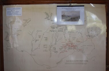
Map, Early Squatters Stations 1837-1838
... Pastoralism Stations Farming Settlement Squatters Reproduction of a coloured map shows pastoral stations around the Geelong area from 1837-1940. Early ...The map shows rivers and pastoral holdings from 1837 to 1838. Stations occupied around Geelong in 1837 are shown in red and those occupied in 1838 are shown in black. Reproduction of a coloured map shows pastoral stations around the Geelong area from 1837-1940. pastoralism, stations, farming, settlement, squatters -
 Mont De Lancey
Book, Janice Newton, The First Selectors of Mt. Evelyn: a summary of files from the Department of Lands, Laverton Archives, 1996
... early land selections in 1865. Early settlement was difficult due to poor soil, leading to subdivision and later agricultural use. Early farmers struggled with thin soil until the 1900s. Mt. Evelyn - History Farms history Farming ...Janice Newton researched the early selectors through Lands Department files and has documented the history on the Mt Evelyn Community Website.A small green paperback book of the First Selectors of Mt. Evelyn who took up land after the 1869 Selection Acts - 1870 - 1890 with the land numbers. The information on the selections is listed alphabetically by name of listed selector. Some files were not found. The wrap around paper cover is a photocopy of the redrawn Parish map of the Mt Evelyn post-code area with selectors' names, Lot numbers and some current roads and streets shown. Inside the front cover is an explanation of the details within, a key to map lines, scale, and publishing details. pp.41.non-fictionJanice Newton researched the early selectors through Lands Department files and has documented the history on the Mt Evelyn Community Website.mt. evelyn - history, farms history, farming settlement, farming australia -
 Mont De Lancey
Book, Monbulk Historical Society, Monbulk in Photographs: Volume 3, A Growing Community, 1993
... The series is broken down into three chronological volumes:Volume 1: The Early Settlers (1893–1920) - Focuses on initial settlement, hardships, and family life featuring over 150 black and white images.Volume 2: One Big Family (1920–1950) - Documents the growth of the community, local farming, and everyday life. ...The Monbulk in Photographs series is a localized pictorial history published by the Monbulk Historical Society. Written by Dorothy Williams, the collection preserves the visual heritage of Monbulk, The Patch, and Kallista. The series is broken down into three chronological volumes:Volume 1: The Early Settlers (1893–1920) - Focuses on initial settlement, hardships, and family life featuring over 150 black and white images.Volume 2: One Big Family (1920–1950) - Documents the growth of the community, local farming, and everyday life. Volume 3: A Growing Community (1950–1993) - Follows the town's modernization and development over the latter half of the 20th century.This volume 1 of a series of three titles has a pale pink front cover with a faint outline of a woman or child in the bush. The title is in dark pink lettering at the top with the volume and sub-title at the bottom. In the top right hand corner of the cover is a black Mont de Lancey stamp.The title page has black lettering with an early photograph of the main street of Montrose. There is Acknowledgments, Contents, a statement about 'A Growing Community' and its history and development, 1950 - 1993. The rest of the book is filled with full and half page black and white photographs of the life and times of Montrose's people, which have detailed annotations for each. At the back is a comprehensive list of surnames. Pp.112.non-fictionThe Monbulk in Photographs series is a localized pictorial history published by the Monbulk Historical Society. Written by Dorothy Williams, the collection preserves the visual heritage of Monbulk, The Patch, and Kallista. The series is broken down into three chronological volumes:Volume 1: The Early Settlers (1893–1920) - Focuses on initial settlement, hardships, and family life featuring over 150 black and white images.Volume 2: One Big Family (1920–1950) - Documents the growth of the community, local farming, and everyday life. Volume 3: A Growing Community (1950–1993) - Follows the town's modernization and development over the latter half of the 20th century.monbulk - history, history - the dandenongs, local history