Showing 836 items matching "eltham (vic)"
-
 Eltham District Historical Society Inc
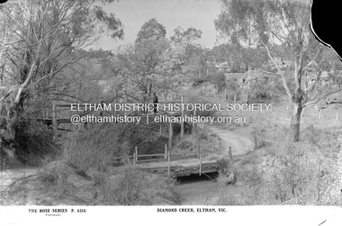
Negative - Photograph, The Rose Stereograph Company, Diamond Creek, Eltham, Vic, c.1919
... Diamond Creek, Eltham, Vic...Diamond Creek, Eltham, Vic., The Rose Series P. 4314, Copyright...The Cutts family understands that for these historically important pieces to rest with one family is to deny others the pleasure of their custodianship. eltham postcard travel rose stereograph company glass plate negative rose series postcard tait train eltham railway station railway store staffs general store diamond creek diamond street bridge lloyd's general store railway station Peter and Elizabeth Pidgeon Collection Diamond Creek, Eltham, Vic., The Rose Series P. 4314, Copyright Glass Plate Negative Size: 9 x 13.9 cm Diamond Creek, Eltham, Vic Negative Photograph The Rose Stereograph Company Lloyds Auctioneers and Valuers Peter Pidgeon ...Shows two bridge crossings over the Diamond Creek in Diamond Street, Eltham. The upper pedestrian crossing provided continual access for foot traffic during times of flood. The railway came to Eltham in 1901, the Eltham Railway Station is visible in the distance as well as a wooden bodied Tait (Red Rattler) First Class train carriage. The Tait train was first introduced in 1910 as a steam locomotive hauled carriage and in 1919 electric motor carriages were introduced however the line to Heidelberg was not electrified till 1921 and to Eltham in April 1923. The Railway General Store on Main Road is visible beyond the station and was built by Luther Haley in 1902. It was the first shop in the present day shopping centre. It was later known as lloyd's stopre (1917-1920) followed by a succession of six other owners until purchased by Eric Staff in 1939. This glass plate negative was used to manufacture postcards (1:1 printing) for commercial sale by the Rose Sterograph Company and its subsidiaries. George Rose founded the Rose Stereograph Company in 1880 and was joined by Herbert (Bert) Cutts in the early 20th Century. The pair formed a lifetime working partnership and strong personal friendship. Assisted by George’s two sons, Herbert George and Walter, and later by Neil Cutts, the Rose Stereograph Company continued its operations for more than 140 years. The company was initially built on stereographs, but as cinema took over and stereographs fell out of fashion, the Rose Stereograph Company developed Australia’s first commercially viable photographic postcard business. Specialising in postcards of iconic historical moments and significant landmarks, The Rose Stereograph Company became a staple of the Australian travel industry.This remarkable collection of glass plate negatives, transparencies, and postcards – arguably Australia’s most significant photography collection outside of public hands – has been passed down through the generations, surviving war, relocation, and the harsh Victorian climate. The historic Rose Stereograph collection is the culmination of George Rose’s dream of capturing and preserving precious moments in time and remains the legacy of the Rose and Cutts families. It is with great sadness that the Cutts family says goodbye to a collection that spans five generations and 140 years. The Cutts family understands that for these historically important pieces to rest with one family is to deny others the pleasure of their custodianship.Glass Plate Negative Size: 9 x 13.9 cmDiamond Creek, Eltham, Vic., The Rose Series P. 4314, Copyrighteltham, postcard, travel, rose stereograph company, glass plate negative, rose series postcard, tait train, eltham railway station, railway store, staffs general store, diamond creek, diamond street bridge, lloyd's general store, railway station, peter and elizabeth pidgeon collection -
 Eltham District Historical Society Inc
Book, Nina Kelabora, Welcome : a gift to you, our new neighbours, from the extended Eltham community / produced by Nina Kelabora (graphic designer) and Lara McKinley (principal photographer), December 2016
... Eltham (Vic.)......Welcome to Eltham (Vic.)...Welcome : a gift to you, our new neighbours, from the extended Eltham community / produced by Nina Kelabora (graphic designer) and Lara McKinley (principal photographer) Book Nina Kelabora Lara McKinley Welcome to Eltham (Vic.) ...In 2016 the Welcome to Eltham community project started to welcome Syrian refugees into the community and made Welcome Butterflies to say welcome to them. In addition to the physical book, EDHS also holds several hundred digital images pertaining to the development of the Welcome to Eltham campaign, photographs, artworks and graphic designs, which resulted in the publication of this book. EDHS also holds further material from the period 2016 to 2017 associated with the Welcome to Eltham campaign group. Contents: 1. Welcome Book Welcome Book includes selected page extracts and images as published December 2016 Contents: • Greetings to our Country P2 • Offering P8 • Your neighbours P10 • Rotary P39 • Eltham Baptist Church P44 • Eltham Farmers Market stall holders P48 • The Eltham community P54 • Surrounding communities P60 • Our Lady Help of Christians Primary School P64 • Nillumbik Greens P66 • Our Lady Help of Christians Church Eltham P68 • Catholic Care Eltham P70 • St Vincent’s P71 • Montmorency South Primary School P72 • Victoria Police P73 • Catholic Ladies College P74 • Warrandyte P76 • Eltham Toy Library P78 • Eltham-Montmorency Uniting Church P82 • Gingerbread P84 • Scouts P86 • Eltham businesses P89 • Surrounding communities P96 • The Seed P101 2. Administration 1. Welcome to Eltham Infant Plan, Purpose and Scope (Aug. 2016) 2. Circle of Friends; A draft proposal from Welcome to Eltham, 26 August 2016 3. Welcome to Eltham; a resident support group for refugees settling in Eltham (Sep. 2016) 4. Welcome to Eltham; Purpose and Scope (Sep. 2016) 5. Welcome to Eltham Plan (Sep. 2016); 10 pages typed of tasks broken into four categories, 10 pages 6. Welcome to Eltham Team/Volunteer organisation structure, volunteers’ skills assessment and role assignments, strategies, 11 pages 7. Briefing Document: Refugees being welcomed in Eltham, 2 Oct. 2016; 5 pages 8. Public Engagement Plan, 2 Oct. 2016; 2 pages 9. Welcome to Eltham 2016 Review, Values and Structure, 2017 10. Welcome to Eltham Incorporated Financial Report July 2016 – June 2017; 3 pages 11. Letter: Nina Kelabora and Welcome to Eltham Team to Bolton Street Fruit Market re offer to provide fresh fruit, 30 Jun. 2017 12. Welcome to Eltham Incorporated Annual Report 2016–2017; Oct. 2017; 4 pages 13. Certificate: Jagajaga Community Australia Day Award 2018 to Nina Kelabora, signed Jenny Macklin MP, Federal Member for Jagajaga 14. Certificate: Jagajaga Community Australia Day Award 2018 to Welcome to Eltham, signed Jenny Macklin MP, Federal Member for Jagajaga 15. Letter: Simon Le Plastrier, Principal, Eltham College to Nina Kelabora, 20 April 2018 offering congratulations for the work achieved by Welcome to Eltham group 16. Photo: River pebble covered in spray paint of multiple colours. The rock was used to hold down templates for painting butterflies on the footpaths near Andrew park as a counter to protesters assembling for the ‘Battle for Eltham’ demonstration on 5 November 2016 17. Photo: Welcome to Eltham team member, Gillian Essex 18. Photo: Welcome to Eltham team member, Kirsten Bate 19. Photo: Welcome to Eltham team member, Lara McKinley 20. Photo: Welcome to Eltham team member, Nina Kelabora 21. Photo: Welcome to Eltham team member, Sarah Hooten 22. Incorporation • AGM-minutes-2017 • Certificate of Incorporation • Mission and Values • Ordinary Business of the AGM 2017 • Welcome to Eltham Rules 23. Advocacy • Eltham Butterfly Effect Corflute panel design 5 November 2016 Rally • MemeFest PowerPoint presentation 23 November 2016 • Oxfam PowerPoint presentation 16 June 2017 • Eltham Rotary PowerPoint presentation 1 June 2017 • Welcome to Eltham Gift Card artwork 3. Artwork • Logo: Welcome to Eltham • 12 artworks by children of the Eltham Child Care Co-Operative (ECCC) o Me at the Immigration Museum by Ethan B. o Immigration Museum by Edie o Me with my family and lots of hearts by Charlotte o My suitcase like the refugees we learnt about with Bec by Jarvis o Me at the football with my friends by Harley o My suitcase if I had to leave the country by Ellen o Me at the park near the library by Chloe o Books at the library by Addison o Ethan’s grandfather who died in the war and this is him in his grave by Ethan o A nursery by Annabel o The age care home we visit by Ari o This is my mum the Ranger by Mia • Butterfly Effect, Ona Henderson 2016, inscribed “Dedicated to Nina, in appreciation of your butterfly effect for ‘Welcome to Eltham’; reproduced p1 • Ona and Sid gifting her artwork for use by the campaign; reproduced p1 • Duat and Iuk, Mandy Nicholson, Wurundjeri woman; reproduced p3 • These hands welcome you to Australia, Mungo, Warrandyte resident; reproduced p9 • The Library by Rose; reproduced p15 • Welcome to Eltham from Maia; reproduced p19 • Billy, Warrandyte resident; reproduced p20 • Through my window, Janet Boddy; reproduced p23 • Eryn and Lachie, Eltham residents; reproduced p25 • Eva, Eltham resident; reproduced p29 • This is the community hall across from my house by Cinta; reproduced p30 • Welcome, Brenda, Eltham resident; reproduced p34 • Flying over Kerry Crescent, Kerry, Eltham resident; reproduced p38 • A dragon called 'fat' from Joe, 6; reproduced p42 • A rainbow-heart-welcome from Trixie, 8; reproduced p42 • A lovely message from Sarah; reproduced p53 • Monique; reproduced p56 • Tom; reproduced p56 • Josh; reproduced p56 • Chloe; reproduced p56 • Jack; reproduced p57 • Mia; reproduced p57 • Ann Curry, Montmorency resident; reproduced p60 • From Mia: "Keep your head up high and be confident. I'm sure that you will soon find that Eltham is a very nice place and I hope you can have a happy life."; reproduced p77 • Amy; reproduced p79 • Ben; reproduced p80 • Welcome, Kayla, Warrandyte resident; reproduced p94 • Lucas; reproduced p98 • Ale; reproduced p98 • Grace; reproduced p99 • Hugo; reproduced p99 4. Australian-Syrian Charity • ASC – Certificate of Appreciation; Awarded from Australian-Syrian Charity presented to Welcome to Eltham Group by Rev. Fr. Samir Haddad, ASC president, 30 Sep. 2016 including two images of Father Samir and WTE organiser, Nina Kelabora 5. Butterflies • 148 images of handcrafted butterflies and artwork of butterflies edited for reproduction throughout the Welcome to Eltham book and for use on other placards, gift cards and promotional materials including the original source photographs (232 total) • 128 other images of butterflies submitted or photographed installed at various locations around Eltham • 11 images of metal butterfly artworks created by Linda MacAulay and Tim Read showing the works during creation at Bend of Isles and at initial install at the roundabout on Main Road at Luck Street then at the final install to greet the new arrivals and residents alike at St Vincents Aged Care Services (since demolished). 6. Eltham and Surrounds Residents and Local Businesses • 195 photos (157 published in book) submitted by local residents and businesses with people holding Welcome to Eltham placards including: Eltham Farmer’s Market, Eltham Baptist Church, CatholicCare Eltham, Nillumbik Greens, Hurstbridge Wattle Festival, Our Lady Help of Christians Eltham, Our Lady Help of Christians Primary School, Montmorency South Primary School, Warrandyte Primary School, Bronnie Hattam, Mayor, Nillumbik Shire Council, Vicki Ward, MP for Eltham, Jenny Macklin, Member for Jagajaga, Bend of Isles, Eltham Toy Library, Eltham Library, Eltham-Montmorency Uniting Church, Catholic Ladies College (CLC), First Eltham North Scouts, Warrandyte Primary School, Ona Henderson and many individuals and businesses. 7. Events • Alistair Knox Park, 12 August 2016 • Syrian Community Dinner, 30 September 2016 • Pop up Picnic, Eltham North Adventure Playground, 1 October 2016 • Alistair Knox Park, 7 October 2016 • At Our Lady of Help of Christians, 7 October 2016 • Andrew Park Butterfly Effect v Battle for Eltham, 5 November 2016 • City Rally, 5 November 2016 • Eltham Library Children’s Garden, 12 November 2016 • Eltham Festival, 13 November 2016 • Welcome Book Fundraiser, St Margaret’s Church, 11 December 2016 • Nillumbik International Women’s Day Dinner 9 March 2017 • Bush Dance, 17 June 2017 • Eltham Police Morning Tea, 29 July 2017 8. House warmers • Approximately 40 images of gift care items donated (food, drink, blankets, etc) intended as housewarming hampers 9. Media Media Releases • Eltham elders take to social media to welcome refuges, video goes viral; Wednesday 28 October 2016 • Eltham locals use their bodies to say WELCOME to refugees; 1 October 2016 • Community group welcomes Minister’s decision so refugees can call Eltham home; 5 October 2016 • Locals answer far-right “Battle for Eltham” with butterflies: thousand of them; 5 November 2016 Newspaper articles • Group fosters goodwill; organisation works to assist refugees; Brittany Shanahan; Diamond Valley Leader, Wednesday, August 17, 2016, p3 • Refugees are welcome (Gillian); Care is for the elderly alone (Fred); Plenty of positives in plan (Kirstin); Open your hearts and doors (Alison); Flood of families a worry (Cath), Conversations, Diamond Valley Leader, Wednesday, August 17, 2016, p11 • Support refugee housing; Diamond Valley Leader, Pamela Nash via Facebook, Janet R. Body, Eltham, Glenise Michaelson, Montmorency; Letters (online), 5 October 2016 • Refugees find a haven, and, Groups to fundraise for arrivals; Wednesday, October 12, 2016, p5 • Site for resettlement of refugees on a flood plane (Jacquie Bellchambers); Accommodating young families from a foreign culture in an established western culture retirement home will only lead to both parties feeling …. (Margit Alm); Great news for our community … (Nean Tatnal); Conversations, Diamond Valley Leader, Wednesday, October 12, 2016, p19 • Refugee scrap looms; daughter of Eltham aged-care resident upset as extreme group hijacks debate; Brittany Shanahan. Diamond Valley Leader, Wednesday, October 26, 2016, p1 • Many ready to welcome refugees into community (Megan Anne) and others; Conversations, Diamond Valley Leader, Wednesday, October 26, 2016, p20 • On a wing and a prayer; Chris Vedelago, Tammy Mills and Mark Hawthorne; Sunday Age, November 6, 2016, p3. – It was billed as the “Battle for Eltham”, but in te end the butterflies carried the day. • Rally hits trade; Diamond Valley Leader, Wednesday, November 9, 2016, p1 • Protests bad for business; Brittany Shanahan; Diamond Valley Leader, Wednesday, November 9, 2016, p8 • Police earn praise for keeping protest calm; Re: Battle for Eltham rally (Maree Quinlan) and others; Conversations, Diamond Valley Leader, Wednesday, November 9, 2016, p14 • Butterflies to counter anti-Muslim protest; Bianca Hall and Marissa Calligeros, The Age, November 5, 2016 • Rally created challenges but it’s time to move on; Re: Battle for Eltham rally (Local Area Commander Acting Inspector Danielle Leemon) and others; Conversations, Diamond Valley Leader, Wednesday, November 16, 2016, p19 • Praise for warm welcome (Linda Jajawi) and others also photo “Officers from Eltham police station welcomed newly arrived refugees to the community”; Conversations, Diamond Valley Leader, Wednesday, August 9, 2017, p15 • Refugees welcomed; Diamond Valley Leader, n.d. 2017, p12 • Refugee plan riles; Retirement centre residents voice concerns; Brittany Shanahan, Diamond Valley Leader; n.d. 2016 Facebook Responses • Responses top frequent Facebook comments regarding the housing of refugees in aged care at Eltham 10. Placards and Promotional Flyers • Selection of placard images and Welcome to Eltham Gift Card artwork 11. St Vincents • Two hand drawn sketches showing plan views of proposed front and rear units at St Vincents to be used by refugees 12. Videos • Feisties; several local seniors read online comments made by objectors and offer their own opinions; 00.02.28 • Tour of unit at St Vincents, 31 July 2016; 00.00.44 • Drone view of people creating Welcome sign at Eltham North Adventure Playground, 14 September 2016; 00.00.14 • Launching of the butterflies (campaign); Nina Kelabora releases the first butterfly into the wild; 00.00.24 • Gillian Essex, Welcome to Eltham, discussing counter strategy to protest demonstration (Battle for Eltham) scheduled for later in the day; 5 November 2016; 00.01.45 • Glenise Michaelson, Eltham local for 69 years discussing counter strategy to protest demonstration (Battle for Eltham) scheduled for later in the day; 5 November 2016; 00.01.30 • The Butterfly Effect, counter strategy to protesters 5 November 2016 Battle for Eltham rally; 00.02.24 with ten associated photos of the seniors involved; 31 October 2016 • Butterfly art ninjas 1 (15 secs), 2 (26 secs) and 3 (14 secs), showing the butterflies remaining in existence on the paths around Andrew Park, 16 November 2016 • Butterfly capture and release with Nina Kelabora– butterflies around Andrew Park relocated to the Children’s garden at Eltham Library, 17 November 2016; 00.00.28eltham (vic.), welcome to eltham (vic.), syrian refugees, refugees, social life and customs, butterflies, welcome butterflies, nina kelabora collection -
 Eltham District Historical Society Inc
Negative - Photograph, Rose Stereograph Company, View at Eltham, Vic, c.1920
... View at Eltham, Vic....View at Eltham, Vic. Looking from Main Road near Henry Street towards Montmorency showing the railway trestle bridge. ...Eltham District Historical Society Inc 728 Main Rd Eltham melbourne View at Eltham, Vic. Looking from Main Road near Henry Street towards Montmorency showing the railway trestle bridge. ...View at Eltham, Vic. Looking from Main Road near Henry Street towards Montmorency showing the railway trestle bridge. Henry Street road reserve on west side of Main road in foreground. c.1920 Copy of Rose Series Postcard P. 4348. (The Rose Stereograph Company) George Rose founded the Rose Stereograph Company in 1880 and was joined by Herbert (Bert) Cutts in the early 20th Century. The pair formed a lifetime working partnership and strong personal friendship. Assisted by George’s two sons, Herbert George and Walter, and later by Neil Cutts, the Rose Stereograph Company continued its operations for more than 140 years. The company was initially built on stereographs, but as cinema took over and stereographs fell out of fashion, the Rose Stereograph Company developed Australia’s first commercially viable photographic postcard business. Specialising in postcards of iconic historical moments and significant landmarks, The Rose Stereograph Company became a staple of the Australian travel industry. This photo forms part of a collection of photographs gathered by the Shire of Eltham for their centenary project book,"Pioneers and Painters: 100 years of the Shire of Eltham" by Alan Marshall (1971). The collection of over 500 images is held in partnership between Eltham District Historical Society and Yarra Plenty Regional Library (Eltham Library) and is now formally known as 'The Shire of Eltham Pioneers Photograph Collection.' It is significant in being the first community sourced collection representing the places and people of the Shire's first one hundred years.Digital image 4 x 5 inch B&W Negbridge street, eltham, eltham railway trestle bridge, postcard, rose stereograph company, shire of eltham pioneers photograph collection, trestle bridge -
 Eltham District Historical Society Inc
Photograph, View at Eltham, Vic, c.1924
... View at Eltham, Vic....Copy of possible Rose Stereograph Co. postcard “View at Eltham, Vic.”, c.1924 looking southwest from Main Road near York Street to Bridge Street and the original 1875 bridge across what is now the Alistair Knox Park The land in the foreground was first bought from the Crown by J.M. ...Eltham District Historical Society Inc 728 Main Rd Eltham melbourne Copy of possible Rose Stereograph Co. postcard “View at Eltham, Vic.”, c.1924 looking southwest from Main Road near York Street to Bridge Street and the original 1875 bridge across what is now the Alistair Knox Park The land in the foreground was first bought from the Crown by J.M. ...Copy of possible Rose Stereograph Co. postcard “View at Eltham, Vic.”, c.1924 looking southwest from Main Road near York Street to Bridge Street and the original 1875 bridge across what is now the Alistair Knox Park The land in the foreground was first bought from the Crown by J.M. Holloway in 1851. The land was sub-divided and called "Little Eltham". Bridge Street was created as part of the sub-division. Most of the sub-division was residential lots but the creek valley was divided into lots for small farms. Council started to buy the land for the Eltham Town park in the early 1960s. The area was used as a garbage tip and filled above the flood plain of the creek. Development of the land for a park began in the early 1970s. The house on the right was owned for many years by the Hill family until Council bought it in the early 1960s. The house was built in the 1850s or 60s. The house on the left stood on what is now the southwest corner of Susan and Bridge Streets. The Braithwaite family was associated with this house. The double line of fencing in the foreground was a continuation of York Street to the creek. The Bridge Street bridge was built in 1875 and replaced in 1958. (Ref: Early view of Little Eltham; Byways of History by Colleen Ison, Publication unk, 24 August 1982) Reproduced on p61 of 'Pioneers & Painters' Date estimated on same as View at Hurstbridge featuring Wattle Valley EstateThis photo forms part of a collection of photographs gathered by the Shire of Eltham for their centenary project book,"Pioneers and Painters: 100 years of the Shire of Eltham" by Alan Marshall (1971). The collection of over 500 images is held in partnership between Eltham District Historical Society and Yarra Plenty Regional Library (Eltham Library) and is now formally known as the 'The Shire of Eltham Pioneers Photograph Collection.' It is significant in being the first community sourced collection representing the places and people of the Shire's first one hundred years.Digital image 120 format B&W negative Prints 17 x 25 cm and 10 x 15 cmsepp, shire of eltham pioneers photograph collection, eltham, bridge street, bridge, alistair knox park, braithwaite, bridge street bridge, eltham town park, hill family home, main road, pioneers and painters, york street -
 Eltham District Historical Society Inc
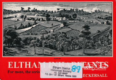
Book, Kenneth Eric Eckersall, Eltham inhabitants : for most, the serious part : church in community 1850-2000 / Kenneth Eric Eckersall, 2000
... Eltham Uniting Church (Eltham, Vic.)...Book Book Kenneth Eric Eckersall Eltham Uniting Church (Eltham, Vic.) ...ArtStreams: Arts in Banyule, Darebin, Manningham, Nillumbik, Whittlesea & Yarra Vol. 5 No. 6 Summer Issue, 2000 Book Review "Ken Eckersall has been a member of the Eltham community for 40 years. He has been a member of the Methodist / Uniting Church for all of his 66 years. Having moved from being a compositer in the printing trade to a teacher and lecturer, in his retirement he has become an historian. Eltham Inhabitants is ostensibly a history of the Eltham Uniting Church, written to celebrate its 150th anniversary. The book is considerably broader than the commission suggests. This is hinted at in Eckersalls reference to the Eltham Wesleyan/Methodist/Uniting Church. Eckersall writes on the history and philosophy of the church from its beginnings in the 18th century to the present and places it in the context of the sociology and history of the period. Recognising the nexus between church and community, the author has in large part written a history of the Eltham community including the churches of other denomination(s). There are very few artists, academics or other interesting characters from the district who don't get a mention. Despite a plethora of information about the church, Eltham Inhabitants is a fund of historical information on many other fronts."Paperback; viii, 175 p. : ill. ; 21 cm. 2 copieseltham, churches, uniting church, eltham uniting church -
 Eltham District Historical Society Inc
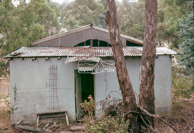
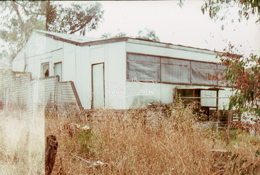
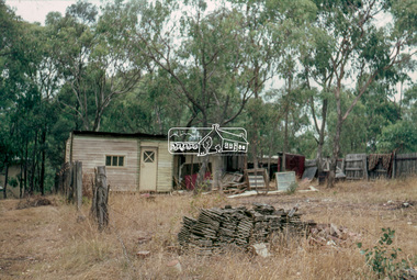
Slide - Photograph, Unidentified derelict house on a bush block possibly Eltham / Research, Vic, c.1966
... Unidentified derelict house on a bush block possibly Eltham / Research, Vic....Eltham...Research (Vic.)...Eltham District Historical Society Inc 728 Main Rd Eltham melbourne houses Unidentified Eltham Research (Vic.) Bush garden 35mm colour positive transparency blue Agfacolour Service plastic mount Unidentified derelict house on a bush block possibly Eltham / Research, Vic. ...35mm colour positive transparency blue Agfacolour Service plastic mounthouses, unidentified, eltham, research (vic.), bush garden -
 Eltham District Historical Society Inc
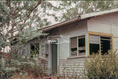
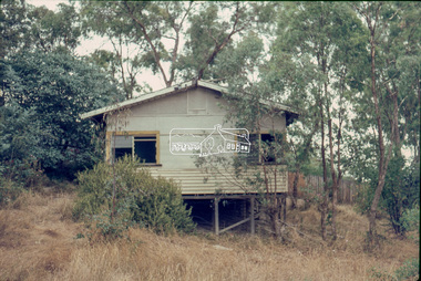
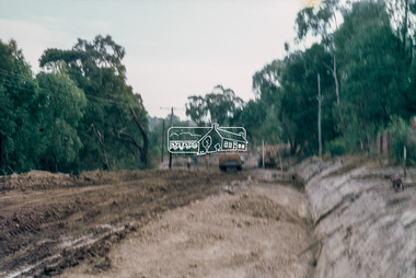
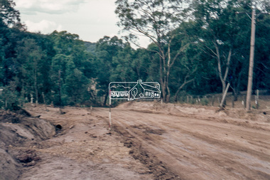
Slide - Photograph, Roadworks, unidentifed road, Eltham district, possibly Eltham / Research, Vic, c.1967
... Roadworks, unidentifed road, Eltham district, possibly Eltham / Research, Vic....Eltham...Research (Vic.)...Eltham District Historical Society Inc 728 Main Rd Eltham melbourne Unidentified Eltham Research (Vic.) Infrastructure Road construction Roadworks 35mm colour positive transparency blue Agfacolour Service plastic mount Roadworks, unidentifed road, Eltham district, possibly Eltham / Research, Vic. ...35mm colour positive transparency blue Agfacolour Service plastic mountunidentified, eltham, research (vic.), infrastructure, road construction, roadworks -
 Eltham District Historical Society Inc
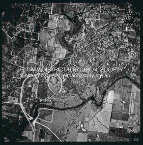
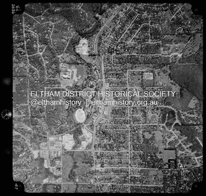
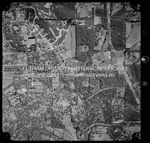
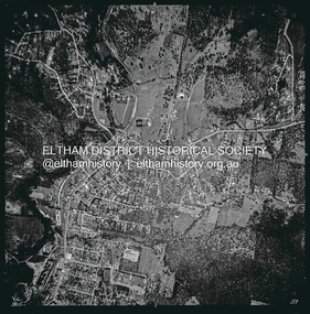
Photograph - Aerial Photograph, Landata, Eltham, Vic, Apr. 1963
... Eltham, Vic....Historic Aerial Imagery Source: Landata.vic.gov.au Aerial Photo Details: Project No :486 Project : MELBOURNE (1963) PROJECT Run : 7 Frame : 232 Date : 04/1963 Film Type : B/W Camera : RC8 Flying Height : 5100 Scale : 9600 Film Number : 1805 GDA2020 : 37°44'03"S, 145°08'33"E MGA2020 : 336329, 5822040 (55) Melways : 21 H10 (ed. 42) Aerial Photo Neil Webster Collection 1963-04 Bolton Steet Brougham Steet Eltham Eltham Lower Park Fitzsimons Lane Bridge Kent Hughes Road Melway 21H10 Yarra River Digital jpg and electronic PDF file Eltham, Vic. Photograph Aerial Photograph Landata ...Centred on present day Eltham Lower Park bounded by Brougham Street to north, Yarra River and Fitzsimons Lane Bridge to south, Main Road at Kent Hughes Road to east and Bolton Street to west. Historic Aerial Imagery Source: Landata.vic.gov.au Aerial Photo Details: Project No :486 Project : MELBOURNE (1963) PROJECT Run : 7 Frame : 232 Date : 04/1963 Film Type : B/W Camera : RC8 Flying Height : 5100 Scale : 9600 Film Number : 1805 GDA2020 : 37°44'03"S, 145°08'33"E MGA2020 : 336329, 5822040 (55) Melways : 21 H10 (ed. 42)aerial photo, neil webster collection, 1963-04, bolton steet, brougham steet, eltham, eltham lower park, fitzsimons lane bridge, kent hughes road, melway 21h10, yarra river -
 Eltham District Historical Society Inc
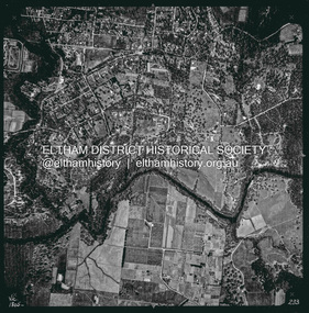
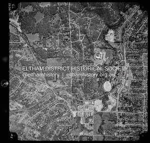
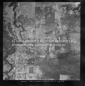
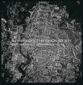
Photograph - Aerial Photograph, Landata, Eltham, Vic, Apr. 1963
... Eltham, Vic....Historic Aerial Imagery Source: Landata.vic.gov.au Aerial Photo Details: Project No :486 Project : MELBOURNE (1963) PROJECT Run : 7 Frame : 233 Date : 04/1963 Film Type : B/W Camera : RC8 Flying Height : 5100 Scale : 9600 Film Number : 1805 GDA2020 : 37°44'04"S, 145°09'10"E MGA2020 : 337237, 5822053 (55) Melways : 22 A10 (ed. 42) Aerial Photo Neil Webster Collection 1963-04 Eltham Falkiner Street Griffith Park Road Melway 22A10 Mount Pleasant Road Reynolds Road Templestowe Yarra River Digital jpg and electronic PDF file Eltham, Vic. Photograph Aerial Photograph Landata ...Centred on present day Griffith Park Road, Eltham bounded by Mount Pleasant Road to north, Yarra River and Templestowe to south, Main Road at Reynolds Road to east and Falkiner Street to west. Historic Aerial Imagery Source: Landata.vic.gov.au Aerial Photo Details: Project No :486 Project : MELBOURNE (1963) PROJECT Run : 7 Frame : 233 Date : 04/1963 Film Type : B/W Camera : RC8 Flying Height : 5100 Scale : 9600 Film Number : 1805 GDA2020 : 37°44'04"S, 145°09'10"E MGA2020 : 337237, 5822053 (55) Melways : 22 A10 (ed. 42)aerial photo, neil webster collection, 1963-04, eltham, falkiner street, griffith park road, melway 22a10, mount pleasant road, reynolds road, templestowe, yarra river -
 Eltham District Historical Society Inc
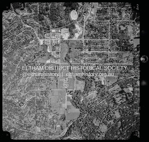
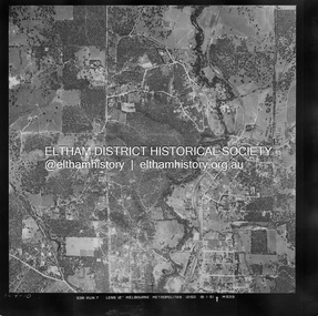
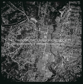
Photograph - Aerial Photograph, Landata, Eltham, Vic, Apr. 1972
... Eltham, Vic....Historic Aerial Imagery Source: Landata.vic.gov.au Aerial Photo Details: Project No :985 Project : MELBOURNE 1972 Run : 26 Frame : 191 Date : 04/1972 Film Type : B/W Camera : RC10 Flying Height : 5700 Scale : 9600 Film Number : 2636 GDA2020 : 37°41'56"S, 145°09'26"E MGA2020 : 337533, 5826000 (55) Melways : 22 A1 (ed. 42) Aerial Photo Neil Webster Collection 1972-04 Allendale Road Eltham Eltham North Zig Zag Road Banks Road Coolabah Drive Melway 22A1 Park West Road Parsons Road Digital jpg and electronic PDF file Eltham, Vic. Photograph Aerial Photograph Landata ...Centred on present day Zig Zag Road near Coolabah Drive, Eltham bounded by Allendale Road to north, Park West Road to south, Parsons Road to east and Banks Road to west. Historic Aerial Imagery Source: Landata.vic.gov.au Aerial Photo Details: Project No :985 Project : MELBOURNE 1972 Run : 26 Frame : 191 Date : 04/1972 Film Type : B/W Camera : RC10 Flying Height : 5700 Scale : 9600 Film Number : 2636 GDA2020 : 37°41'56"S, 145°09'26"E MGA2020 : 337533, 5826000 (55) Melways : 22 A1 (ed. 42)aerial photo, neil webster collection, 1972-04, allendale road, eltham, eltham north, zig zag road, banks road, coolabah drive, melway 22a1, park west road, parsons road -
 Eltham District Historical Society Inc
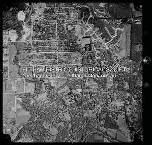
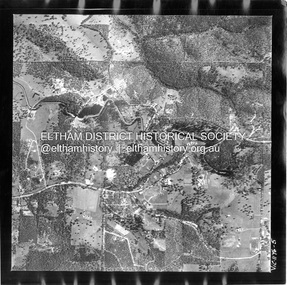
Photograph - Aerial Photograph, Landata, Eltham, Vic, Apr. 1972
... Eltham, Vic....Eltham...Zig Zag Road...frank street...Melway 22D1...Parsons Road...Raglan Road...Research (Vic...Research Shops Eltham Barrel Digital jpg and electronic PDF file Eltham, Vic. Photograph Aerial Photograph Landata ...Centred on present day Parsons Road, Eltham bounded by Allendale Road to north, Frank Street to south, Research Shops and Raglan Road to east and Zig Zag Road to west. Historic Aerial Imagery Source: Landata.vic.gov.au Aerial Photo Details: Project No :985 Project : MELBOURNE 1972 Run : 26 Frame : 192 Date : 04/1972 Film Type : B/W Camera : RC10 Flying Height : 5700 Scale : 9600 Film Number : 2636 GDA2020 : 37°42'00"S, 145°09'59"E MGA2020 : 338360, 5825897 (55) Melways : 22 D1 (ed. 42)aerial photo, neil webster collection, 1972-04, allendale road, eltham, zig zag road, frank street, melway 22d1, parsons road, raglan road, research (vic.), research shops, eltham barrel -
 Eltham District Historical Society Inc
Photograph - Aerial Photograph, Landata, Eltham, Vic, Apr. 1972
... Eltham, Vic....Historic Aerial Imagery Source: Landata.vic.gov.au Aerial Photo Details: Project No :985 Project : MELBOURNE 1972 Run : 27 Frame : 46 Date : 04/1972 Film Type : B/W Camera : RC10 Flying Height : 5700 Scale : 9600 Film Number : 2636 GDA2020 : 37°42'49"S, 145°09'46"E MGA2020 : 338053, 5824365 (55) Melways : 22 C5 (ed. 42) Aerial Photo Neil Webster Collection 1972-04 Eltham Eltham Railway Station Melway 22C5 Mount Pleasant Road Park Road Stokes Orchard Estate Woodridge Estate Digital jpg and electronic PDF file Eltham, Vic. Photograph Aerial Photograph Landata ...Centred on present day Woodridge Estate, Eltham bounded by Park Road to north, Mount Pleasant Road to south, Stokes Orchard Estate to east and Eltham Railway Station to west. Historic Aerial Imagery Source: Landata.vic.gov.au Aerial Photo Details: Project No :985 Project : MELBOURNE 1972 Run : 27 Frame : 46 Date : 04/1972 Film Type : B/W Camera : RC10 Flying Height : 5700 Scale : 9600 Film Number : 2636 GDA2020 : 37°42'49"S, 145°09'46"E MGA2020 : 338053, 5824365 (55) Melways : 22 C5 (ed. 42)aerial photo, neil webster collection, 1972-04, eltham, eltham railway station, melway 22c5, mount pleasant road, park road, stokes orchard estate, woodridge estate -
 Eltham District Historical Society Inc
Photograph - Aerial Photograph, Landata, Eltham, Vic, Apr. 1972
... Eltham, Vic....Historic Aerial Imagery Source: Landata.vic.gov.au Aerial Photo Details: Project No :985 Project : MELBOURNE 1972 Run : 27 Frame : 47 Date : 04/1972 Film Type : B/W Camera : RC10 Flying Height : 5700 Scale : 9600 Film Number : 2636 GDA2020 : 37°42'45"S, 145°09'12"E MGA2020 : 337223, 5824470 (55) Melways : 22 A4 (ed. 42) Aerial Photo Neil Webster Collection 1972-04 Eltham Eltham Railway Station Woodridge Estate Eltham Shops Main Road Melway 22A4 Napoleon Street Park West Road Pryor Street Ryans Road Digital jpg and electronic PDF file Eltham, Vic. Photograph Aerial Photograph Landata ...Centred on present day Main Road at Pryor Street, Eltham bounded by Park West Road to north, Napoleon Street to south, Woodridge Estate to east and Ryans Road to west. Historic Aerial Imagery Source: Landata.vic.gov.au Aerial Photo Details: Project No :985 Project : MELBOURNE 1972 Run : 27 Frame : 47 Date : 04/1972 Film Type : B/W Camera : RC10 Flying Height : 5700 Scale : 9600 Film Number : 2636 GDA2020 : 37°42'45"S, 145°09'12"E MGA2020 : 337223, 5824470 (55) Melways : 22 A4 (ed. 42)aerial photo, neil webster collection, 1972-04, eltham, eltham railway station, woodridge estate, eltham shops, main road, melway 22a4, napoleon street, park west road, pryor street, ryans road -
 Eltham District Historical Society Inc
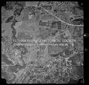
Photograph - Aerial Photograph, Landata, Eltham, Vic, Apr. 1972
... Eltham, Vic....Historic Aerial Imagery Source: Landata.vic.gov.au Aerial Photo Details: Project No :985 Project : MELBOURNE 1972 Run : 27 Frame : 48 Date : 04/1972 Film Type : B/W Camera : RC10 Flying Height : 5700 Scale : 9600 Film Number : 2636 GDA2020 : 37°42'41"S, 145°08'38"E MGA2020 : 336392, 5824574 (55) Melways : 21 H4 (ed. 42) Aerial Photo Neil Webster Collection 1972-04 Eltham Bible Street Brougham Steet Melway 21H4 outlook crescent Progress Road Ryans Road Sandra Avenue Montmorency Digital jpg and electronic PDF file Eltham, Vic. Photograph Aerial Photograph Landata ...Centred on present day Ryans Road at Sandra Avenue, Eltham bounded by Progress Road to north, Brougham Street to south, Bible Street to east and Outlook Crescent to west. Historic Aerial Imagery Source: Landata.vic.gov.au Aerial Photo Details: Project No :985 Project : MELBOURNE 1972 Run : 27 Frame : 48 Date : 04/1972 Film Type : B/W Camera : RC10 Flying Height : 5700 Scale : 9600 Film Number : 2636 GDA2020 : 37°42'41"S, 145°08'38"E MGA2020 : 336392, 5824574 (55) Melways : 21 H4 (ed. 42)aerial photo, neil webster collection, 1972-04, eltham, bible street, brougham steet, melway 21h4, outlook crescent, progress road, ryans road, sandra avenue, montmorency -
 Eltham District Historical Society Inc
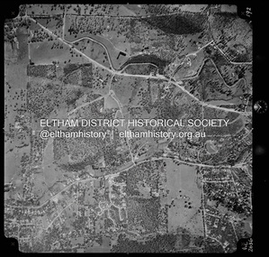
Photograph - Aerial Photograph, Landata, Eltham, Vic, Apr. 1972
... Eltham, Vic....Historic Aerial Imagery Source: Landata.vic.gov.au Aerial Photo Details: Project No :985 Project : MELBOURNE 1972 Run : 28 Frame : 207 Date : 04/1972 Film Type : B/W Camera : RC10 Flying Height : 5700 Scale : 9600 Film Number : 2635 GDA2020 : 37°43'25"S, 145°08'20"E MGA2020 : 335985, 5823223 (55) Melways : 21 G7 (ed. 42) Aerial Photo Neil Webster Collection 1972-04 Eltham Buena Vista Drive Central Park diamond creek trail Eltham Leisure Centre Falkiner Street Grand Boulevard MacMahon Ball Paddock Main Road Melway 21G7 Digital jpg and electronic PDF file Eltham, Vic. Photograph Aerial Photograph Landata ...Centred on present day Diamond Creek Trail at the Eltham Leisure Centre bounded by Central Park to north, Main Road at Falkiner Street to south, MacMahon Ball Paddock to east and Grand Boulevard at Buena Vista Drive to west. Historic Aerial Imagery Source: Landata.vic.gov.au Aerial Photo Details: Project No :985 Project : MELBOURNE 1972 Run : 28 Frame : 207 Date : 04/1972 Film Type : B/W Camera : RC10 Flying Height : 5700 Scale : 9600 Film Number : 2635 GDA2020 : 37°43'25"S, 145°08'20"E MGA2020 : 335985, 5823223 (55) Melways : 21 G7 (ed. 42)aerial photo, neil webster collection, 1972-04, eltham, buena vista drive, central park, diamond creek trail, eltham leisure centre, falkiner street, grand boulevard, macmahon ball paddock, main road, melway 21g7 -
 Eltham District Historical Society Inc
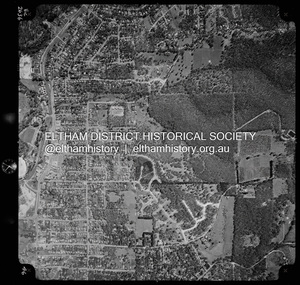
Photograph - Aerial Photograph, Landata, Eltham, Vic, Apr. 1972
... Eltham, Vic....Historic Aerial Imagery Source: Landata.vic.gov.au Aerial Photo Details: Project No :985 Project : MELBOURNE 1972 Run : 28 Frame : 208 Date : 04/1972 Film Type : B/W Camera : RC10 Flying Height : 5700 Scale : 9600 Film Number : 2635 GDA2020 : 37°43'29"S, 145°08'54"E MGA2020 : 336816, 5823118 (55) Melways : 21 J8 (ed. 42) Aerial Photo Neil Webster Collection 1972-04 Eltham Arthur Street Dalton Street Eucalyptus Road Kent Hughes Road Melway 21J8 Mount Pleasant Road Susan Street Yarra River Digital jpg and electronic PDF file Eltham, Vic. Photograph Aerial Photograph Landata ...Centred on present day Dalton Street at Mount Pleasant Road, Eltham bounded by Arthur Street to north, Yarra River and Kent Hughes Road to south, Eucalyptus Road to east and Susan Street to west. Historic Aerial Imagery Source: Landata.vic.gov.au Aerial Photo Details: Project No :985 Project : MELBOURNE 1972 Run : 28 Frame : 208 Date : 04/1972 Film Type : B/W Camera : RC10 Flying Height : 5700 Scale : 9600 Film Number : 2635 GDA2020 : 37°43'29"S, 145°08'54"E MGA2020 : 336816, 5823118 (55) Melways : 21 J8 (ed. 42)aerial photo, neil webster collection, 1972-04, eltham, arthur street, dalton street, eucalyptus road, kent hughes road, melway 21j8, mount pleasant road, susan street, yarra river -
 Eltham District Historical Society Inc
Photograph - Aerial Photograph, Landata, Eltham, Vic, Apr. 1972
... Eltham, Vic....Historic Aerial Imagery Source: Landata.vic.gov.au Aerial Photo Details: Project No :985 Project : MELBOURNE 1972 Run : 28 Frame : 209 Date : 04/1972 Film Type : B/W Camera : RC10 Flying Height : 5700 Scale : 9600 Film Number : 2635 GDA2020 : 37°43'33"S, 145°09'28"E MGA2020 : 337647, 5823013 (55) Melways : 22 B8 (ed. 42) Aerial Photo Neil Webster Collection 1972-04 Eltham Bible Street Mays Road Melway 22B8 Nyora Road Reynolds Road Stringybark Road Yarra River Digital jpg and electronic PDF file Eltham, Vic. Photograph Aerial Photograph Landata ...Centred on present day Mays Road at Stringybark Road, Eltham bounded by Nyora Road to north, Yarra River to south, Reynolds Road to east and Bible Street to west. Historic Aerial Imagery Source: Landata.vic.gov.au Aerial Photo Details: Project No :985 Project : MELBOURNE 1972 Run : 28 Frame : 209 Date : 04/1972 Film Type : B/W Camera : RC10 Flying Height : 5700 Scale : 9600 Film Number : 2635 GDA2020 : 37°43'33"S, 145°09'28"E MGA2020 : 337647, 5823013 (55) Melways : 22 B8 (ed. 42)aerial photo, neil webster collection, 1972-04, eltham, bible street, mays road, melway 22b8, nyora road, reynolds road, stringybark road, yarra river -
 Eltham District Historical Society Inc
Photograph - Aerial Photograph, Landata, Eltham, Vic, Jan. 1951
... Eltham, Vic....Eltham...Neil Webster Collection...Arthur Street...Beard Street...Catholic Ladies College...frank street...Main Road...Maroondah Aqueduct...Maroong Drive...Melway 22B3...Research (Vic...Digital jpg and electronic PDF file Eltham, Vic. Photograph Aerial Photograph Landata ...Centred on Beard Street between Main Road and Frank Street, Eltham bounded by Maroondah Aqueduct to north, Arthur Street to south, Maroong Drive to east and Catholic Ladies College to west. Historic Aerial Imagery Source: Landata.vic.gov.au Aerial Photo Details: Project No :65 Project : MELBOURNE AND METROPOLITAN PROJECT NO. 2 Run : 7 Frame : 9 Date : 01/1951 Film Type : B/W Camera : EAG9 Flying Height : 12200 Scale : 12000 Film Number : 1419 GDA2020 : 37°42'23"S, 145°09'39"E MGA2020 : 337874, 5825170 (55) Melways : 22 B3 (ed. 42)Historical aerial photos and photo maps provide viusal evidence of the chronology of changes to the built landscape of the district and assist in dating other imagesaerial photo, 1951-01, eltham, neil webster collection, arthur street, beard street, catholic ladies college, frank street, main road, maroondah aqueduct, maroong drive, melway 22b3, research (vic.) -
 Eltham District Historical Society Inc
Photograph - Aerial Photograph, Landata, Eltham, Vic, Jan. 1951
... Eltham, Vic....Historic Aerial Imagery Source: Landata.vic.gov.au Aerial Photo Details: Project No :65 Project : MELBOURNE AND METROPOLITAN PROJECT NO. 2 Run : 7 Frame : 10 Date : 01/1951 Film Type : B/W Camera : EAG9 Flying Height : 12200 Scale : 12000 Film Number : 1419 GDA2020 : 37°42'14"S, 145°08'36"E MGA2020 : 336339, 5825416 (55) Melways : 21 H2 (ed. 42) Historical aerial photos and photo maps provide viusal evidence of the chronology of changes to the built landscape of the district and assist in dating other images Aerial Photo 1951-01 Eltham Neil Webster Collection Allendale Road Allison Crecent Reserve Dudley Street Melway 21H2 Scenic Crescent Sherbrook Road St Helena Road Zig Zag Road Digital jpg and electronic PDF file Eltham, Vic. Photograph Aerial Photograph Landata ...Centred on Allison Crecent Reserve, Sherbrook Road and Scenic Crescent, Eltham bounded by Allendale Road to north, Dudley Street to south, Zig Zag Road to east and St Helena Road to west. Historic Aerial Imagery Source: Landata.vic.gov.au Aerial Photo Details: Project No :65 Project : MELBOURNE AND METROPOLITAN PROJECT NO. 2 Run : 7 Frame : 10 Date : 01/1951 Film Type : B/W Camera : EAG9 Flying Height : 12200 Scale : 12000 Film Number : 1419 GDA2020 : 37°42'14"S, 145°08'36"E MGA2020 : 336339, 5825416 (55) Melways : 21 H2 (ed. 42)Historical aerial photos and photo maps provide viusal evidence of the chronology of changes to the built landscape of the district and assist in dating other imagesaerial photo, 1951-01, eltham, neil webster collection, allendale road, allison crecent reserve, dudley street, melway 21h2, scenic crescent, sherbrook road, st helena road, zig zag road -
 Eltham District Historical Society Inc
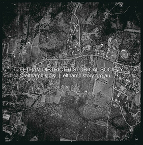
Photograph - Aerial Photograph, Landata, Eltham, Vic, Feb. 1956
... Eltham, Vic....Eltham...Leane Drive...Lorimer Road...Maroondah Aqueduct...Melway 22H1...Norman Road...Parsons Road...Research (Vic...Thompson Crescent Digital jpg and electronic PDF file Eltham, Vic. Photograph Aerial Photograph Landata ...Centred on present day Parsons Avenue at Leane Drive near the Maroondah Aqueduct, Eltham bounded by Lorimer Road to north, Thompson Crescent and Norman Road to south, Bells Hill Road to east and Parsons Road to west Historic Aerial Imagery Source: Landata.vic.gov.au Aerial Photo Details: Project No :250 Project : MELBOURNE OUTER SUBURBS PROJECT Run : 19 Frame : 5 Date : 02/1956 Film Type : B/W Camera : EAG9 Flying Height : 10000 Scale : 12000 Film Number : 1176 GDA2020 : 37°42'04"S, 145°11'09"E MGA2020 : 340064, 5825786 (55) Melways : 22 H1 (ed. 42)aerial photo, 1956-02, neil webster collection, allendale road, bells hill road, eltham, leane drive, lorimer road, maroondah aqueduct, melway 22h1, norman road, parsons road, research (vic.), thompson crescent -
 Eltham District Historical Society Inc
Photograph - Aerial Photograph, Landata, Eltham, Vic, Apr. 1963
... Eltham, Vic....Historic Aerial Imagery Source: Landata.vic.gov.au Aerial Photo Details: Project No :486 Project : MELBOURNE (1963) PROJECT Run : 5 Frame : 59 Date : 04/1963 Film Type : B/W Camera : RC8 Flying Height : 5100 Scale : 9600 Film Number : 1805 GDA2020 : 37°42'24"S, 145°08'52"E MGA2020 : 336716, 5825114 (55) Melways : 21 J3 (ed. 42) Aerial Photo Neil Webster Collection Eltham 1963-04 Arthur Street Banks Road Glen Park Road Maroondah Aqueduct Melway 21J3 Parsons Road Digital jpg and electronic PDF file Eltham, Vic. Photograph Aerial Photograph Landata ...Centred on present day Zig Zag Road and Main Road, Eltham bounded by Maroondah Aqueduct to north, Thompson Crescent and Arthur Street to south, Parsons Road to east and Glen Park Road and Banks Road to west. Historic Aerial Imagery Source: Landata.vic.gov.au Aerial Photo Details: Project No :486 Project : MELBOURNE (1963) PROJECT Run : 5 Frame : 59 Date : 04/1963 Film Type : B/W Camera : RC8 Flying Height : 5100 Scale : 9600 Film Number : 1805 GDA2020 : 37°42'24"S, 145°08'52"E MGA2020 : 336716, 5825114 (55) Melways : 21 J3 (ed. 42)aerial photo, neil webster collection, eltham, 1963-04, arthur street, banks road, glen park road, maroondah aqueduct, melway 21j3, parsons road -
 Eltham District Historical Society Inc
Photograph - Aerial Photograph, Landata, Eltham, Vic, Apr. 1963
... Eltham, Vic....Eltham...1963-04...Diosma Road...Floriston Grove...Maroondah Aqueduct...Melway 22B3...Park West Road...Research (Vic...Research Shops Digital jpg and electronic PDF file Eltham, Vic. Photograph Aerial Photograph Landata ...Centred on present day Floriston Grove, Eltham bounded by Maroondah Aqueduct to north, Thompson Crescent and Diosma Road to south, Research Shops to east and Glen Park Road and Park West Road to west. Historic Aerial Imagery Source: Landata.vic.gov.au Aerial Photo Details: Project No :486 Project : MELBOURNE (1963) PROJECT Run : 5 Frame : 60 Date : 04/1963 Film Type : B/W Camera : RC8 Flying Height : 5100 Scale : 9600 Film Number : 1805 GDA2020 : 37°42'24"S, 145°09'29"E MGA2020 : 337622, 5825128 (55) Melways : 22 B3 (ed. 42)aerial photo, neil webster collection, eltham, 1963-04, diosma road, floriston grove, maroondah aqueduct, melway 22b3, park west road, research (vic.), research shops -
 Eltham District Historical Society Inc
Photograph - Aerial Photograph, Landata, Eltham, Vic, Apr. 1963
... Eltham, Vic....Historic Aerial Imagery Source: Landata.vic.gov.au Aerial Photo Details: Project No :486 Project : MELBOURNE (1963) PROJECT Run : 6 Frame : 123 Date : 04/1963 Film Type : B/W Camera : RC8 Flying Height : 5100 Scale : 9600 Film Number : 1805 GDA2020 : 37°43'12"S, 145°08'54"E MGA2020 : 336800, 5823623 (55) Melways : 21 J6 (ed. 42) Aerial Photo Neil Webster Collection 1963-04 Bolton Steet Elsa Court Eltham John Street Main Road main road bridge Melway 21J6 Wattle Grove Digital jpg and electronic PDF file Eltham, Vic. Photograph Aerial Photograph Landata ...Centred on present day John Street, Eltham between Main and Bible streets bounded by Elsa Court to north, Main Road Bridge to south, Wattle Grove to east and Bolton Street to west. Historic Aerial Imagery Source: Landata.vic.gov.au Aerial Photo Details: Project No :486 Project : MELBOURNE (1963) PROJECT Run : 6 Frame : 123 Date : 04/1963 Film Type : B/W Camera : RC8 Flying Height : 5100 Scale : 9600 Film Number : 1805 GDA2020 : 37°43'12"S, 145°08'54"E MGA2020 : 336800, 5823623 (55) Melways : 21 J6 (ed. 42)aerial photo, neil webster collection, 1963-04, bolton steet, elsa court, eltham, john street, main road, main road bridge, melway 21j6, wattle grove -
 Eltham District Historical Society Inc
Photograph - Aerial Photograph, Landata, Eltham, Vic, Apr. 1963
... Eltham, Vic....Historic Aerial Imagery Source: Landata.vic.gov.au Aerial Photo Details: Project No :486 Project : MELBOURNE (1963) PROJECT Run : 6 Frame : 124 Date : 04/1963 Film Type : B/W Camera : RC8 Flying Height : 5100 Scale : 9600 Film Number : 1805 GDA2020 : 37°43'12"S, 145°08'16"E MGA2020 : 335876, 5823604 (55) Melways : 21 G6 (ed. 42) Aerial Photo Neil Webster Collection 1963-04 Bible Street Bolton Street Eltham Eltham Ridge Main Road Montmorency Rattray Road Reichelt Avenue Digital jpg and electronic PDF file Eltham, Vic. Photograph Aerial Photograph Landata ...Centred on present day Eltham Ridge, Bolton Street, Eltham bounded by Elsa Court to north, Main Road to south, Bible Street to east and Reichelt Avenue and Rattray Road to west. Historic Aerial Imagery Source: Landata.vic.gov.au Aerial Photo Details: Project No :486 Project : MELBOURNE (1963) PROJECT Run : 6 Frame : 124 Date : 04/1963 Film Type : B/W Camera : RC8 Flying Height : 5100 Scale : 9600 Film Number : 1805 GDA2020 : 37°43'12"S, 145°08'16"E MGA2020 : 335876, 5823604 (55) Melways : 21 G6 (ed. 42)aerial photo, neil webster collection, 1963-04, bible street, bolton street, eltham, eltham ridge, main road, montmorency, rattray road, reichelt avenue -
 Eltham District Historical Society Inc
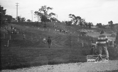
Photograph, ELTHAM ARBOR DAY 1973 - Alistair Knox with school children of the Shire of Eltham, Vic, planting native trees in the Town Park, 10 October 1973, 1973-10-10
... ELTHAM ARBOR DAY 1973 - Alistair Knox with school children of the Shire of Eltham, Vic, planting native trees in the Town Park, 10 October 1973...REF: 783 SOURCE: Shire of Eltham (Eltham District Historical Society) Eltham Town Park would later be renamed Alistair Knox Park Main Road to left and Bridge Street to right - looking southeast eltham arbor day alistair knox alistair knox park eltham town park main road bridge street Black and white photograph ELTHAM ARBOR DAY 1973 - Alistair Knox with school children of the Shire of Eltham, Vic, planting native trees in the Town Park, 10 October 1973 Photograph ...ELTHAM - ARBOR DAY, 10 Oct 1973. School children of the Shire of Eltham planting trees (previously planned to take place during the visit of Sir Rohan Delacombe to the Shire on 19th September, 1973 but cancelled that day due to inclement weather). REF: 783 SOURCE: Shire of Eltham (Eltham District Historical Society) Eltham Town Park would later be renamed Alistair Knox Park Main Road to left and Bridge Street to right - looking southeastBlack and white photographeltham, arbor day, alistair knox, alistair knox park, eltham town park, main road, bridge street