Showing 235 items matching "field staff"
-
 University of Melbourne, Burnley Campus Archives
Document, Re-organization of field staff, 1950
... Re-organization of field staff...Memorandum on re-organization of field staff...University of Melbourne, Burnley Campus Archives 500 Yarra Boulevard Richmond melbourne memorandum staff Memorandum on re-organization of field staff Re-organization of field staff Document ...Memorandum on re-organization of field staffmemorandum, staff -
University of Melbourne, Burnley Campus Archives
Document, Notes on field staff at Burnley, c. 1958
... Notes on field staff at Burnley...field staff...University of Melbourne, Burnley Campus Archives 500 Yarra Boulevard Richmond melbourne field staff burnley 7 sets of notes, mostly handwritten Notes on field staff at Burnley Document ...7 sets of notes, mostly handwrittenfield staff, burnley -
University of Melbourne, Burnley Campus Archives
Document, Proposed re-organization of field staff, 1957
... Proposed re-organization of field staff...field staff...University of Melbourne, Burnley Campus Archives 500 Yarra Boulevard Richmond melbourne field staff burnley Table of staffing Proposed re-organization of field staff Document ...Table of staffingfield staff, burnley -
 University of Melbourne, Burnley Campus Archives
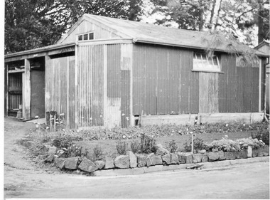
Photograph - Black and white print, E.M. Gibson, Pasture Branch Equipment Shed, c. 1951
... ...field staff...Black and white photograph of the "Pasture Branch (Agrostology) Equipment Shed & general store & field staff room. 250 yards from nearest part of Pasture Field." ...pasture branch agrostology equipment shed general store field staff e. m. gibson collection field staff room 315/12 Black and white photograph of the "Pasture Branch (Agrostology) Equipment Shed & general store & field staff room. 250 yards from nearest part of Pasture Field." ...Black and white photograph of the "Pasture Branch (Agrostology) Equipment Shed & general store & field staff room. 250 yards from nearest part of Pasture Field." E M Gibson315/12pasture branch, agrostology, equipment shed, general store, field staff, e. m. gibson collection, field staff room -
 Bendigo Military Museum
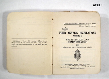
Manual - FIELD SERVICE, STAFF AND STANDING ORDERS, 1938 - 1955
... FIELD SERVICE, STAFF AND STANDING ORDERS...Inside book - “Field Service Regulations Vol 1 1930 Organisation and Administration, Serial No.10 Nov 1938” 2. “Staff...Book - cardboard cover, cream with black print - 209 pages. Manual FIELD SERVICE, STAFF AND STANDING ORDERS ...Items in the collection re Colonel J. W. Swatton refer Cat No 6719.2P for his service details. 1. Book - cloth cover, red, paper, black print - 423 pages. 2. Pamphlet - paper, cream with black print - 11 pages. 3. Book - cardboard cover, cream with black print - 209 pages.1. Inside book - “Field Service Regulations Vol 1 1930 Organisation and Administration, Serial No.10 Nov 1938” 2. “Staff Duties in the Field 1949, Appendix F, Vehicle Unit Signs” 3. “Standing Orders for the Equipment of the Australian Military Forces and Australian Cadet Corps 1955”passchendaele barracks trust, colonel j w swatton, manuals -
 Department of Energy, Environment and Climate Action
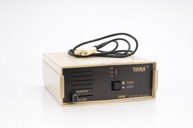
TARA radio/phone interface
... TARA Systems Australia Connected to FCV radios to allow field staff to call a fixed line telephone / office etc Used by for the Minister Joan Kirner vehicle....Bushfire Radios Forests Commission Victoria (FCV) TARA Systems Australia Connected to FCV radios to allow field staff to call a fixed line telephone / office etc Used by for the Minister Joan Kirner vehicle. ...After the 1939 bushfires, the Forests Commission Victoria invested heavily in a radically new communications network. After suffering some inevitable delays due to the war, radio VL3AA switched into full operation in October 1945 proudly beaming out 200 watts across the State. But by today’s standards, the technology was primitive and the reception poor unless the user was on a high point somewhere. The radio signal was "line-of-sight" and bounced between fire towers and relay transmitters across the mountains back to the District offices. The advent of solid-state electronics in the 1960s replaced the more delicate valve sets which enabled greater use of vehicle mounted radios. The Commission continued to research, develop and build new radios at its many workshops around Victoria. The network was supported by a large team of skilled radio technicians. The more secure and versatile State Mobile Radio (SMR) digital trunk system came into operation in about 1995. Upgraded Tait Radios were purchased in 2014 after recommendations of the 2009 Bushfires Royal Commission. But it was the convergence of separate technologies such as 5G mobile phones, high-capacity and light-weight lithium batteries, Wi-Fi, the ever-expanding internet, cloud data storage, digital cameras, GPS, personal organisers and hundreds of supporting Apps into powerful smartphones and tablets which revolutionised bushfire communications from the mid-2000s. Portable radio with leather carrycase and strapTARA Systems Australia Connected to FCV radios to allow field staff to call a fixed line telephone / office etc Used by for the Minister Joan Kirner vehicle.bushfire, radios, forests commission victoria (fcv) -
 University of Melbourne, Burnley Campus Archives
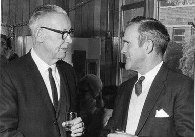
Photograph - Black and white print, Retirement, 1972
... ...staff...field...Nicholls was on the Staff at Burnley 1946-1979 (Field Superintendent)....Nicholls was on the Staff at Burnley 1946-1979 (Field Superintendent). retirement 1972 curator rslt w.j. nicholls random sample laying tests department of agriculture staff field superintendent w. macauley bill macauley poultry egglaying competition On reverse, "Retirement 13/7/72 Mr. ...Bill Macauley, RSLT Random Sample Laying Tests, retired after 42 years with the Department Of Agriculture. W.J. Nicholls was on the Staff at Burnley 1946-1979 (Field Superintendent).Black and white photograph. W. McCauley, Curator Random Sample Egglaying Competition talking to W. J. Nicholls, Staff at a retirement party.On reverse, "Retirement 13/7/72 Mr. W. McCauley Curator RSLT W.J. Nicholls."retirement, 1972, curator, rslt, w.j. nicholls, random sample laying tests, department of agriculture, staff, field superintendent, w. macauley, bill macauley, poultry, egglaying competition -
 University of Melbourne, Burnley Campus Archives
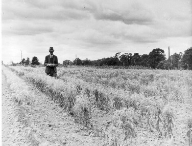
Photograph - Black and white print, E.M. Gibson, Man Styanding in a Field of Crops, 1947
... Black and white photograph of a man standing in a field of crops, possibly Staff member in Agrostology area or not at Burnley....University of Melbourne, Burnley Campus Archives 500 Yarra Boulevard Richmond melbourne staff agrostology e. m. gibson collection crops 49/15 Black and white photograph of a man standing in a field of crops, possibly Staff member in Agrostology area or not at Burnley. ...Black and white photograph of a man standing in a field of crops, possibly Staff member in Agrostology area or not at Burnley.49/15staff, agrostology, e. m. gibson collection, crops -
 Bendigo Military Museum
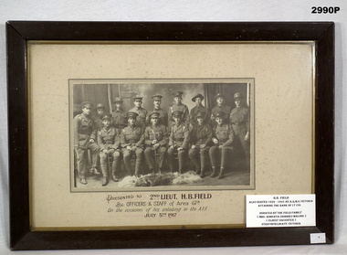
Photograph - PHOTOGRAPH WW1, FRAMED, c.1917
... Botton centre: “Presented to 2nd Lieut. H. B. Field by Officers & Staff of Area 67B. On the occasion of his enlisting in the AIF July 5th 1917”....Passchendaele barracks trust 67th Bn framed Botton centre: “Presented to 2nd Lieut. H. B. Field by Officers & Staff of Area 67B. On the occasion of his enlisting in the AIF July 5th 1917”. ...H.B. Field, refer Cat No 890P for his service details.Wooden frame, cream border, glass fronted, sepia group photo of officers & staff.Botton centre: “Presented to 2nd Lieut. H. B. Field by Officers & Staff of Area 67B. On the occasion of his enlisting in the AIF July 5th 1917”.passchendaele barracks trust, 67th bn, framed -
 Orbost & District Historical Society
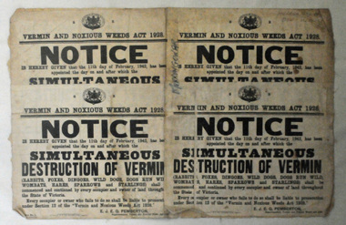
map/poster, Victorian Government Printer, 22.4.1926
... Pemberton who published this poster was Superintendent of Field Staff, Dept. of Lands and Survey. ...Pemberton who published this poster was Superintendent of Field Staff, Dept. of Lands and Survey. This map and posters are significant records of early settlement history in Murrangower, between Cabbage Tree and Orbost, map-Murrangower poster-vermin-and-noxious-weeds Murrangower-settlement "DON MEHLERT" in black pen. ...The Department of Crown Lands and Survey was originally established in 1857 as part of the Board of Land and Works. In 1964 it ceased to be controlled by the Board. The Department functioned for almost twenty more years before being combined with other Ministries to form the Department of Conservation, Forests and Land. It was responsible for the management of the State's Crown land and pastoral estates. This map was used by Don Mehlert after 1928. The VERMIN AND NOXIOUS WEEDS ACT 1928 was an Act to consolidate the Law relating relating to Vermin and Noxious Weeds. E. J. E. G. Pemberton who published this poster was Superintendent of Field Staff, Dept. of Lands and Survey. This map and posters are significant records of early settlement history in Murrangower, between Cabbage Tree and Orbost,A paper map of Murrangower showing settlement subdivisions. This is glued onto the back of four overlapping cloth poster of "Notices of Vermin Destruction". All print is black."DON MEHLERT" in black pen. Pike's block shaded in blue. School site marked in blue pencil. on poster "MURRANGOWAR" along side.map-murrangower poster-vermin-and-noxious-weeds murrangower-settlement -
 University of Melbourne, Burnley Campus Archives
Photograph - Colour prints and negatives, Konica, Student Gardens & Arborists, Unknown
... 15 colour photographs. 4-7 Students constructing their gardens in the Field Station with Staff member Ian Winstone. First constructed 1981 and 1-3 students learning Arboriculture. ...University of Melbourne, Burnley Campus Archives 500 Yarra Boulevard Richmond melbourne field station students arboriculture student gardens orchard ian winstone 15 colour photographs. 4-7 Students constructing their gardens in the Field Station with Staff member Ian Winstone. First constructed 1981 and 1-3 students learning Arboriculture. ...15 colour photographs. 4-7 Students constructing their gardens in the Field Station with Staff member Ian Winstone. First constructed 1981 and 1-3 students learning Arboriculture. Some scanned.field station, students, arboriculture, student gardens, orchard, ian winstone -
 Returned Nurses RSL Sub-branch
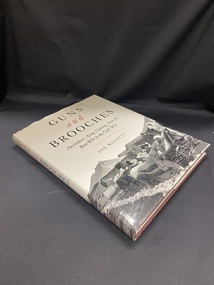
Book - Hardcover book, Jan Bassett, Guns and Brooches : Australian Army Nursing from the Boer War to the Gulf War, 1992
... The title is printed in black and red text across the top half of the cover, the lower half shows a photographic image of patients lying on stretchers covered in blankets and being tended to by nursing staff outside field hospital tents. The image is black and white....The title is printed in black and red text across the top half of the cover, the lower half shows a photographic image of patients lying on stretchers covered in blankets and being tended to by nursing staff outside field hospital tents. The image is black and white. ...Vivian Bullwinkle - Changi - Malaria - Dysentery - Typhoid - Betty Jeffrey - War injuries and illnesses. Guns and Brooches investigates the contradictions, paradoxes, and anomalies that have arisen because army nurses have been 'in but not of' the army. They have faced discrimination as women in a men's organisation. Guns have replaced brooches as part of their uniforms as 'total war' has increasingly made a mockery of the distinction between non-combatants and combatants, a meaningless distinction for the nurses machine-gunned on Banka Island during the Second World War. Those sent to 'outpost of the empire', such as India during the First World War, have also had to cope with difficulties caused by deep-seated imperial tensions. [From Trove]Maroon coloured hardcover book covered with a grey dustjacket. The title is printed in black and red text across the top half of the cover, the lower half shows a photographic image of patients lying on stretchers covered in blankets and being tended to by nursing staff outside field hospital tents. The image is black and white.non-fictionVivian Bullwinkle - Changi - Malaria - Dysentery - Typhoid - Betty Jeffrey - War injuries and illnesses. Guns and Brooches investigates the contradictions, paradoxes, and anomalies that have arisen because army nurses have been 'in but not of' the army. They have faced discrimination as women in a men's organisation. Guns have replaced brooches as part of their uniforms as 'total war' has increasingly made a mockery of the distinction between non-combatants and combatants, a meaningless distinction for the nurses machine-gunned on Banka Island during the Second World War. Those sent to 'outpost of the empire', such as India during the First World War, have also had to cope with difficulties caused by deep-seated imperial tensions. [From Trove]australian army nursing service, military nursing, women and war -
 Returned Nurses RSL Sub-branch
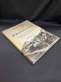
Book - Paperback book, Jan Bassett, Guns and Brooches : Australian Army Nursing from the Boer War to the Gulf War, 1992
... The title is printed in black and red text across the top half of the cover, the lower half shows a photographic image of patients lying on stretchers covered in blankets and being tended to by nursing staff outside field hospital tents. The image is black and white....The title is printed in black and red text across the top half of the cover, the lower half shows a photographic image of patients lying on stretchers covered in blankets and being tended to by nursing staff outside field hospital tents. The image is black and white. ...Vivian Bullwinkle - Changi - Malaria - Dysentery - Typhoid - Betty Jeffrey - War injuries and illnesses. Guns and Brooches investigates the contradictions, paradoxes, and anomalies that have arisen because army nurses have been 'in but not of' the army. They have faced discrimination as women in a men's organisation. Guns have replaced brooches as part of their uniforms as 'total war' has increasingly made a mockery of the distinction between non-combatants and combatants, a meaningless distinction for the nurses machine-gunned on Banka Island during the Second World War. Those sent to 'outpost of the empire', such as India during the First World War, have also had to cope with difficulties caused by deep-seated imperial tensions. [From Trove]Cream coloured softcover book that has yellowed around the borders. The title is printed in black and red text across the top half of the cover, the lower half shows a photographic image of patients lying on stretchers covered in blankets and being tended to by nursing staff outside field hospital tents. The image is black and white.non-fictionVivian Bullwinkle - Changi - Malaria - Dysentery - Typhoid - Betty Jeffrey - War injuries and illnesses. Guns and Brooches investigates the contradictions, paradoxes, and anomalies that have arisen because army nurses have been 'in but not of' the army. They have faced discrimination as women in a men's organisation. Guns have replaced brooches as part of their uniforms as 'total war' has increasingly made a mockery of the distinction between non-combatants and combatants, a meaningless distinction for the nurses machine-gunned on Banka Island during the Second World War. Those sent to 'outpost of the empire', such as India during the First World War, have also had to cope with difficulties caused by deep-seated imperial tensions. [From Trove]australian army nursing service, military nursing, women and war -
 Bendigo Military Museum
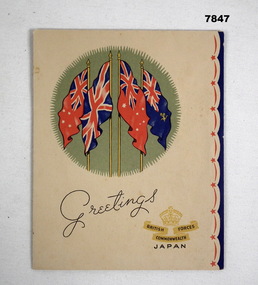
Card - BCOF CARD, JAPAN, C.1947
... The card is written by Harold Charles Grant VX81115 Staff Captain Welfare Leave Hostels HQ BCOF Xmas 1947. The card is to H.B. Field 1st & 2nd AIF, refer Cat No 890P for his service details. ...Bendigo Military Museum 37 - 39 Pall Mall Bendigo goldfields The card is written by Harold Charles Grant VX81115 Staff Captain Welfare Leave Hostels HQ BCOF Xmas 1947. The card is to H.B. Field 1st & 2nd AIF, refer Cat No 890P for his service details. ...The card is written by Harold Charles Grant VX81115 Staff Captain Welfare Leave Hostels HQ BCOF Xmas 1947. The card is to H.B. Field 1st & 2nd AIF, refer Cat No 890P for his service details. Harold Grant initially enlisted in the CMF No V36042 on 2.7.1940 age 36 years, transferred to the 2nd AIF 1.7.1942, listed as served in the Middle East 6.9.1942 - 12.2.1943, served with BCOF in Japan, listed as served in the Interim Army 1.7.1947 - 12.10.1948, discharged from the Army 19.10.1948Xmas card folding, colour, front has 4 flags with "Greetings" under then a crown with text, inside 1st fold in blue pen a short note starting with "Bert", 3rd page has Xmas and New Year greetings in black print, under hand written in blue pen a note to "Lt Col & Mrs H.B. Field", opened out to full page a letter to "Bert" and signed off by "Hal"On front page, "British Commonwealth Forces Japan"card, xmas, bcof, malone collection -
 Bendigo Military Museum
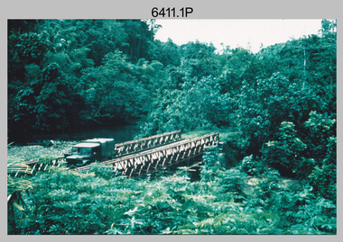
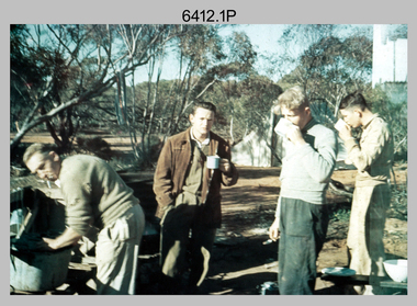
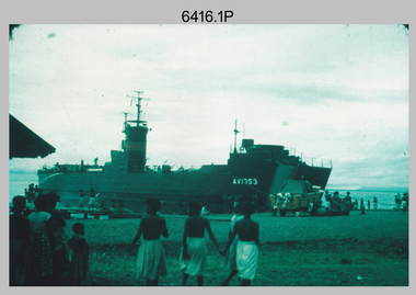
Photograph - Royal Australian Survey Corps Surveyors in the Field – Project Cutlass, New Guinea, 1956 – 1957
... This is a set of 23 photographs of surveyors and support staff in the field undertaking tasks in New Guinea 1956 – 1957. ...This is a set of 23 photographs of surveyors and support staff in the field undertaking duties during Project Cutlass located in New Ireland, New Guinea 1956 – 1957. ...Bendigo Military Museum 37 - 39 Pall Mall Bendigo goldfields This is a set of 23 photographs of surveyors and support staff in the field undertaking tasks in New Guinea 1956 – 1957. ...This is a set of 23 photographs of surveyors and support staff in the field undertaking tasks in New Guinea 1956 – 1957. The surveyors were employed in the establishment of mapping and geodetic control for Project Cutlass, the “Ship-Shore” survey of the New Ireland province. In this survey operation surveyors used theodolites to observe horizontal and vertical angles and chains to measure base line distances between survey stations. Bob Skitch shown in photo .7P was in the 2nd year of his career in the Australian Army. He achieved the rank of Lieutenant-Colonel, and his last appointment was the CO of the Army Survey Regiment from 1976 to 1980.This is a set of 23 photographs of surveyors and support staff in the field undertaking duties during Project Cutlass located in New Ireland, New Guinea 1956 – 1957. The photographs were printed on photographic paper and are part of the Army Survey Regiment’s Collection. The photographs were scanned at 300 dpi. .1) - Photo, colour, 1956. Surveyors travelling main road from Kavieng to Namatanai, New Ireland. .2) - Photo, colour, 1956. Unidentified surveyors assessing recovery of their vehicle after bridge collapsed on west side of New Ireland. .3) - Photo, colour, 1956. Unidentified surveyors assessing recovery of their vehicle after bridge collapsed over flooded creek on west side of New Ireland. .4) - Photo, colour, 1956. Survey personnel L to R: Bev Uwins, John Lambie, Bob Thompson, New Ireland. .5) - Photo, colour, 1956. Survey base camp, New Ireland. .6) - Photo, black & white, 1956-1957. Geoff Helsham with possible human remains, New Ireland. .7) - Photo, black & white, 1956-1957. Bob Skitch undertaking survey observations using Wild T2 theodolite, New Ireland. .8) - Photo, black & white, 1956-1957. Chas Beach undertaking survey observations using Wild T2 theodolite, New Ireland. .9) & .10) - Photo, black & white, 1956-1957. Kev Parker (cook) New Ireland. .11) - Photo, colour, 1957. Brian Berkery taking a break, Top Manor Island, Lihir Island Group off New Ireland. Latitude -2° 46”, Longitude 152° 40”. .12) - Photo, colour, 1957. Survey base camp L to R: Chas Beach, Bev Uwins, Feni Islands, New Ireland. Latitude -4° 05”, Longitude 153° 45”. .13) - Photo, colour, 1957. A Hous Kiap. (Kiaps, known formally as district officers and patrol officers, were travelling representatives of the British and Australian governments), New Ireland. .14) & .15) - Photo, colour, 1957. L to R: Joe Farrington, Tom Royle Bob undertaking survey observations using theodolites from an improvised timber tower, New Ireland. .16) & .17) - Photo, colour, 1957. US Army ship FS216 used for ship-to-shore triangulation docked at Rabaul, New Britain. .18) - Photo, colour, 1957. US Army ship FS216 used for ship-to-shore triangulation docked at Kavieng, New Ireland. Sight target on top of mast. .19) - Photo, colour, 1957. Survey personnel onboard US Army ship FS392, L to R: Peter Frodsham, Bob Thompson, Doc Reid, John Underwood, remainder unidentified, New Ireland. .20) - Photo, colour, 1957. Survey base line party heading ashore, New Ireland. .21) - Photo, colour, 1957. Survey personnel rowing US Army assault boat L to R: Kev Parker, Chas Beach, folded up survey beacons overhanging stern, New Ireland. .22) - Photo, colour, 1957. Les Bailey onboard US Army ship departing Rabaul, New Britain for Brisbane. .23) - Photo, colour, 1957. Ron Newman onboard US Army ship departing Rabaul, New Britain for Brisbane. Active volcano in background..1P to .23P annotated on back – ‘Operation Cutlass’, personnel names, the year and the location. royal australian survey corps, rasvy, army survey regiment, fortuna, a, army svy regt, asr, surveying -
 Bendigo Military Museum
Photograph - Royal Australian Survey Corps Surveyors in the Field – Victoria, 1956 - 1958
... This is a set of two photographs of surveyors and support staff in the field undertaking tasks in Victoria 1956 – 1958. ...This is a set of 23 photographs of surveyors and support staff in the field undertaking duties in Victoria 1956 – 1958. ...Bendigo Military Museum 37 - 39 Pall Mall Bendigo goldfields This is a set of two photographs of surveyors and support staff in the field undertaking tasks in Victoria 1956 – 1958. ...This is a set of two photographs of surveyors and support staff in the field undertaking tasks in Victoria 1956 – 1958. The surveyors were employed in the establishment of mapping and geodetic control. In this era surveyors used theodolites to observe horizontal and vertical angles and chains to measure base line distances between survey stations. This is a set of 23 photographs of surveyors and support staff in the field undertaking duties in Victoria 1956 – 1958. The photographs were printed on photographic paper and are part of the Army Survey Regiment’s Collection. The photographs were scanned at 300 dpi. .1) - Photo, colour, 1956. Surveyors enjoying a tea break. L to R: Tom Gilbert (cook), Barry Broad, Tony Slattery, John Van De Graff. Taken at Boonoonar, a locality south of Mildura. .2) - Photo, colour, 1958. Surveyors taking a break from driving. L to R: Leo Bub, Bob Thompson. Taken at Puckapunyal..1P to .2P annotated on back – personnel names, the year and the location. royal australian survey corps, rasvy, army survey regiment, asr, army svy regt, fortuna, surveying -
 Bendigo Military Museum
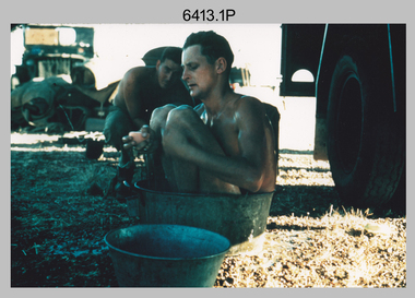
Photograph - Royal Australian Survey Corps Surveyors in the Field – North Queensland, 1958
... This is a set of seven photographs of surveyors and support staff in the field undertaking duties in North Queensland in 1958. ...This is a set of seven photographs of surveyors and support staff in the field undertaking duties in North Queensland in 1958. ...This is a set of seven photographs of surveyors and support staff in the field undertaking duties in North Queensland in 1958. ...This is a set of seven photographs of surveyors and support staff in the field undertaking duties in North Queensland in 1958. The surveyors were employed in the establishment of mapping and geodetic control. In this era surveyors used theodolites to observe horizontal and vertical angles and chains to measure base line distances between survey stations. Bob Skitch shown in photos .4P to .6P was in the 2nd year of his career in the Australian Army. He achieved the rank of Lieutenant Colonel and his last appointment was the CO of the Army Survey Regiment from 1976 to 1980. The annotation on the back of photo .5P ‘Black foreground is where Bob Skitch boiled billy and started a grass fire’.This is a set of seven photographs of surveyors and support staff in the field undertaking duties in North Queensland in 1958. The photographs were printed on photographic paper and are part of the Army Survey Regiment’s Collection. The photographs were scanned at 300 dpi. .1) - Photo, colour, 1958. Surveyor in Nth QLD enjoying a bath. L to R: Don Cocker, Bob Thompson. .2) - Photo, colour, 1958. Don Cocker surveyor in Nth QLD, enjoying a bath. .3) - Photo, colour, 1958. Surveyors Nth QLD undertaking survey observations, using MRA1 tellurometer to measure base-line distances. L to R: Len Davies, Lou Sommer, John Van De Graff. MRA1 was covered to stop overheating. .4) - Photo, colour, 1958. Surveyors south of Richmond, QLD digging holes for the erection of a Bilby observation tower. L to R: John Van De Graff, Bob Skitch, Kev Moody, Mal Hayes, Don Gray .5) - Photo, colour, 1958. Surveyors south of Richmond, QLD erecting a Bilby observation tower. L to R: Tom Royle, Bob Skitch (on ground level), Mal Hayes. .6) - Photo, colour, 1958. Surveyors south of Richmond, QLD erecting a Bilby observation tower. L to R: Tom Royle, Bob Skitch, Mal Hayes, Jim McGill (on ground level). .7) - Photo, colour, 1958. Surveyors south of Richmond, QLD undertaking survey measurements from a Bilby observation tower..1P to .7P annotated on back – personnel names, the year and the location. Annotated on back of .5P ‘Black foreground is where Bob Skitch boiled billy and started a grass fire’.royal australian survey corps, rasvy, army survey regiment, asr, army svy regt, fortuna, surveying -
 Bendigo Military Museum
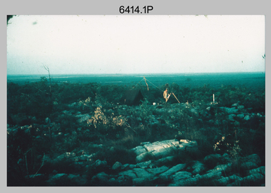
Photograph - Royal Australian Survey Corps Surveyors in the Field – Northern Territory and Queensland, 1959 – 1960
... This is a set of 10 photographs of surveyors and support staff in the field undertaking duties in the Northern Territory and North Queensland in 1959 – 1960. ...This is a set of 10 photographs of surveyors and support staff in the field undertaking duties in the Northern Territory (NT) and Queensland (QLD) in 1959 – 1960. ...This is a set of 10 photographs of surveyors and support staff in the field undertaking duties in the Northern Territory (NT) and Queensland (QLD) in 1959 – 1960. ...This is a set of 10 photographs of surveyors and support staff in the field undertaking duties in the Northern Territory and North Queensland in 1959 – 1960. The surveyors were employed in the establishment of mapping and geodetic control. In this era surveyors used theodolites to observe horizontal and vertical angles and tellurometers to measure base line distances between survey stations. Laplace survey observations seen in Photo .1P was a series of precise observations carried out at geodetic survey stations to determine astronomic latitudes, longitudes and azimuths to achieve maximum precision in the survey network. Laplace observations were necessary in a geodetic network at every 6th survey station, however the National Mapping Council specified at this time the spacing would be ideally between 4-6 survey stations. The cairn shown in photo .4P was built by RASvy as a landmark over a trigonometric survey station. It was dismantled in 1960 to enable re-occupation and survey observations. It was not restored to the condition shown in the photo.This is a set of 10 photographs of surveyors and support staff in the field undertaking duties in the Northern Territory (NT) and Queensland (QLD) in 1959 – 1960. The photographs were printed on photographic paper and are part of the Army Survey Regiment’s Collection. The photographs were scanned at 300 dpi. .1) - Photo, colour, 1959. Tony Slattery occupying a Laplace survey station on a hill in the Mount Young area of the NT. .2) - Photo, colour, 1959. Surveyors’ camp in the Mount Young area of the NT, L to R: Spencer Snow and Tony Slattery. .3) - Photo, colour, 1959. Surveyors’ camp in the Peckman Hill area, near Katherine in the NT. .4) - Photo, colour, 1959. Cairn on Trig Hill, Borroloola, NT. Built by Spencer Snow, Tom Royle and Jack McCabe. .5) - Photo, colour, 1959. Survey party taking a break next to their Austin Champ vehicle, in transit between Katherine, NT and Wyndam WA. L to R: Tony Slattery, Dave Owens, John Van De Graff. .6) - Photo, colour, 1960. Surveyors’ camp between Mount Isa, QLD and Borroloola, NT. L to R: Pat Cox and John Van De Graff prepare their meal on an open fire. .7) - Photo, colour, 1960. Surveyor - Dennis Woods undertaking survey observations, using MRA1 tellurometer to measure base-line distances NW of Mount Isa, QLD. .8) - Photo, colour, 1960. Unidentified surveyors assessing recovery of their stalled Studebaker truck vehicle after attempting a water crossing in the NT. .9) - Photo, colour, 1960. Unidentified surveyor making batches of bread at a camp in the NT. Seen in the photo placing a lid with hot coals onto the camp oven. .10) - Photo, colour, 1960. Unidentified survey party occupying a survey station on a hill in the Mount near the Lawn Hill area, NW of Mount Isa, QLD. A MRA1 tellurometer to measure base-line distances appear on the right side of the photo. .9) - Photo, colour, 1960. Unidentified surveyors assessing recovery of their stalled Studebaker truck vehicle after attempting a water crossing in the NT. .10) - Photo, colour, 1960. Unidentified surveyor making batches of bread at a camp in the NT. Seen in the photo placing a lid with hot coals onto the camp oven. .1P to .10P annotated on back – personnel names, the year and the location. royal australian survey corps, rasvy, army survey regiment, asr, army svy regt, fortuna, surveying -
 Bendigo Military Museum
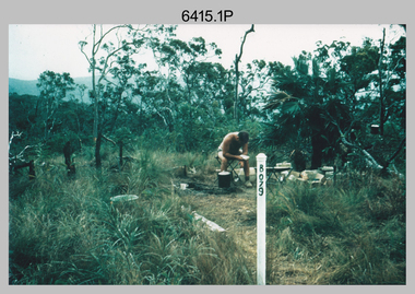
Photograph - Royal Australian Survey Corps Surveyors in the Field – North Queensland and Torres Strait, 1961
... This is a set of five photographs of surveyors and support staff in the field undertaking duties in North Queensland and Torres Strait in 1961. ...This is a set of five photographs of surveyors and support staff in the field undertaking duties in North Queensland and Torres Strait in 1961. ...This is a set of five photographs of surveyors and support staff in the field undertaking duties in North Queensland and Torres Strait in 1961. ...This is a set of five photographs of surveyors and support staff in the field undertaking duties in North Queensland and Torres Strait in 1961. The surveyors were employed in the establishment of mapping and geodetic control. In this era surveyors used theodolites to observe horizontal and vertical angles and tellurometers to measure base line distances between survey stations. In photo .2P Joe Farrington is seen taking survey observations using a Tavistock V500 Series Tavistock theodolite at a survey station between the Edward River and Aurukun in the Cape York Peninsula. The Gulf of Carpentaria appears in the background. From 1957 helicopter transport of survey parties revolutionised transport in remote areas. The civilian helicopter was hired from TAA. This is a set of five photographs of surveyors and support staff in the field undertaking duties in North Queensland and Torres Strait in 1961. The photographs were printed on photographic paper and are part of the Army Survey Regiment’s Collection. The photographs were scanned at 300 dpi. .1) - Photo, colour, 1961. Andy Millar occupying a survey station on a hill in the Cape York Peninsula, QLD. .2) - Photo, colour, 1961. Joe Farrington taking observations with a V500 Series Tavistock geodetic theodolite at a survey station in the Cape York Peninsula, QLD. .3) - Photo, colour, 1961. Daryl Parker taking a break from survey observations on a hill located on Duaun Island QLD, in the Torres Strait, a few miles south of the PNG coastline. Hill height was 975 ft. .4) - Photo, colour, 1961. Three Torres Strait divers L to R: unidentified, Darku and Ray Mau Daryl standing behind a Tavistock geodetic theodolite on a hill located on Duaun Island QLD, in the Torres Strait, a few miles south of the PNG coastline. .5) - Photo, colour, 1961. Andy Millar holding meat from a small turtle on Duaun Island QLD, in the Torres Strait, a few miles south of the PNG coastline. An unidentified Duaun Island local appears in the background..1P to .5P annotated on back – personnel names, the year and the location. royal australian survey corps, rasvy, army survey regiment, asr, army svy regt, fortuna, surveying -
 Bendigo Military Museum
Photograph - Royal Australian Survey Corps Surveyors in the Field – PNG, 1962
... This is a set of four photographs of surveyors and support staff in the field undertaking duties in Dogera, Milne Bay Province and Kerema, Gulf Province of PNG in 1962. ...This is a set of four photographs of surveyors and support staff in the field undertaking duties in PNG in 1962. ...Bendigo Military Museum 37 - 39 Pall Mall Bendigo goldfields This is a set of four photographs of surveyors and support staff in the field undertaking duties in Dogera, Milne Bay Province and Kerema, Gulf Province of PNG in 1962. ...This is a set of four photographs of surveyors and support staff in the field undertaking duties in Dogera, Milne Bay Province and Kerema, Gulf Province of PNG in 1962. The surveyors were employed in the establishment of mapping and geodetic control. In this era surveyors used theodolites to observe horizontal and vertical angles and tellurometers to measure base line distances between survey stations. From 1957 helicopter transport of survey parties revolutionised transport in remote areas.This is a set of four photographs of surveyors and support staff in the field undertaking duties in PNG in 1962. The photographs were printed on photographic paper and are part of the Army Survey Regiment’s Collection. The photographs were scanned at 300 dpi. .1) - Photo, colour, 1962. Unloading survey operation stores from a Landing Ship Medium (LSM) at Dogera, Milne Bay Province, PNG. .2) & .3) - Photo, colour, 1962. Hired civilian helicopter Bell 47G-2 helicopters operating at at Dogera, Milne Bay Province, PNG. .4) - Photo, colour, 1962. Survey party at survey station located near Kerema, Gulf Province southern PNG. L to R: Dave Owens, Keith Broadbent, with local villagers in background..1P to .4P annotated on back – personnel names, the year and the location. royal australian survey corps, rasvy, army survey regiment, asr, army svy regt, fortuna, surveying -
 Bendigo Military Museum
Document - TRAINING COURSE, OFFICER, ARMY
... 3rd Division Staff Officers Training Course - Field Firing Exercise - 22nd May 1973. ...Bendigo Military Museum 37 - 39 Pall Mall Bendigo goldfields 3rd Division Staff Officers Training Course - Field Firing Exercise - 22nd May 1973. ...3rd Division Staff Officers Training Course - Field Firing Exercise - 22nd May 1973. Question and answer document. Part of the "Kevin John Herdman" No. 397661 collection. See Cat No. 5942P for details of his service.Multipage document on both A4 and foolscap paper. Cover sheet has text in black type with handwritten details in red and blue ink. Foolscap sized pages are lined and contain handwritten detail in blue ink. Remaining A4 pages are on green coloured paper with text in black type. Pages are stapled on top LHC.Various comments, answers and anecdotes on pages in red and blue ink.field firing, training course, army, kevin john herdman -
 Bendigo Military Museum
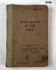
Book - STAFF DUTIES IN THE FIELD, Hunt & Broadhurst Ltd, 1949
... STAFF DUTIES IN THE FIELD...“WO Code No. 8457” “Staff Duties in the Field (Restricted)”...Book STAFF DUTIES IN THE FIELD Hunt & Broadhurst Ltd ...Items in the collection re Lt Col. J. Swatton, refer Cat No 6719.2P for his service history.Book - Hard cardboard cover, cream coloured, black print, green cloth binder to spine.“WO Code No. 8457” “Staff Duties in the Field (Restricted)”passchendaele barracks trust, training book, capt c. j. swatton 38th inf. bn -
 Bendigo Military Museum
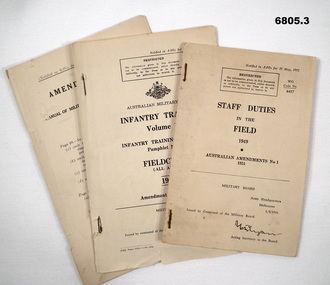
Manual - STAFF, INFANTRY AND LAW, 1941, 1948
... .1) Small paper yellow booklet marked "Staff Duties in the Field" Amend No. 1. Stapled pages heavily redacted - some pages almost all removed. ...Passchendaele Barracks Trust Field Manuals Military Law .1) & .2) Paragraphs all ticked. .3) On back some notations in pencil of Chapter No's. .1) Small paper yellow booklet marked "Staff Duties in the Field" Amend No. 1. ...Various manuals issued to outline & regulate formal behavior in key areas. Given to various Commanders at different levels. Amendments issued on regular basis and gazetted to make official. Ref Cat 6719.2P Lt. Col. Swatton for his service details..1) Small paper yellow booklet marked "Staff Duties in the Field" Amend No. 1. Stapled pages heavily redacted - some pages almost all removed. Pages not numbered. .2) Extract of small yellow booklet marked "Infantry Training Vol 1, 1948". Stapled pages dated Apr 1950. Some pages loose and parts of pages cut out. Some pages loose. .3) Small paper, yellow booklet marked "Manual of Military Law 1941" Serial No. 8, 7 numbered pages and blanks..1) & .2) Paragraphs all ticked. .3) On back some notations in pencil of Chapter No's.passchendaele barracks trust, field manuals, military law -
 Kiewa Valley Historical Society
Photo - Bogong Township, March 1944
... In 1940 Field Headquarters for the Kiewa Scheme were established at Bogong with office, workshop facilities and accommodation for workmen, staff and some families constructed. ...Kiewa Valley Historical Society Mount Beauty Information Centre 31 Bogong High Plains Rd Mt Beauty high-country In 1940 Field Headquarters for the Kiewa Scheme were established at Bogong with office, workshop facilities and accommodation for workmen, staff and some families constructed. ...In 1940 Field Headquarters for the Kiewa Scheme were established at Bogong with office, workshop facilities and accommodation for workmen, staff and some families constructed. (There had been a 'tent camp' on this site in 1939 but was destroyed by bushfires) Construction of accommodation continued until 1947. A total of 40 houses plus a hostel for single staff, post office, police station, medical centre and primary school all with water and sewerage and electricity supply. The staff hostel was known as Kiewa House and is now occupied by the Education Department. Lake Guy was named after Mr. L.T. Guy who was the Resident Engineer in charge of construction work and associated activities on the Kiewa area. He held this position from 1939 to November 1946 when he was transferred to Head Office. The Bogong Township was developed firstly as an accommodation centre (base camp) for construction workers employed under the Kiewa Hydroelectric Scheme. Due to the influx of European workers into the Township the beautification of the immediate surrounds (gardens etc.) had a distinct European flavour. This environment has been very beneficial for tourism in later years. At the completion of the scheme, in the 1960's, the village was opened to public/tourism use. Strict environmental control has not allowed for any extensive redevelopment in tourist accommodation and basically restricted it to the accommodation initially built for the construction workers. Activities such a bike riding, snow skiing, restricted horse riding and bush walking on the Alpine plains and mountains are now a viable part of the Kiewa Valley Tourist Industry. The lake is one of the many water storage reservoirs used to supply the power stations their main power to run the huge turbines generating the final product, electricityBlack and white photograph of Bogong Township taken March 1944Handwritten on the back of photo - Township March '44bogong village, secv -
 Kiewa Valley Historical Society
Photograph - Bogong Village (7 copies), Approx 1940
... In 1940 Field Headquarters for the Kiewa Scheme were established at Bogong with office, workshop facilities and accommodation for workmen, staff and some families constructed. ...Kiewa Valley Historical Society Mount Beauty Information Centre 31 Bogong High Plains Rd Mt Beauty high-country In 1940 Field Headquarters for the Kiewa Scheme were established at Bogong with office, workshop facilities and accommodation for workmen, staff and some families constructed. ...In 1940 Field Headquarters for the Kiewa Scheme were established at Bogong with office, workshop facilities and accommodation for workmen, staff and some families constructed. (There had been a 'tent camp' on this site in 1939 but was destroyed by bushfires) Construction of accommodation continued until 1947. A total of 40 houses plus a hostel for single staff, post office, police station, medical centre and primary school all with water and sewerage and electricity supply. The staff hostel was known as Kiewa House and is now occupied by the Education Department. Lake Guy was named after Mr. L.T. Guy who was the Resident Engineer in charge of construction work and associated activities on the Kiewa area. He held this position from 1939 to November 1946 when he was transferred to Head Office. The Bogong Township was developed firstly as an accommodation centre (base camp) for construction workers employed under the Kiewa Hydroelectric Scheme. Due to the influx of European workers into the Township the beautification of the immediate surrounds (gardens etc.) had a distinct European flavour. This environment has been very beneficial for tourism in later years. At the completion of the scheme, in the 1960's, the village was opened to public/tourism use. Strict environmental control has not allowed for any extensive redevelopment in tourist accommodation and basically restricted it to the accommodation initially built for the construction workers. Activities such a bike riding, snow skiing, restricted horse riding and bush walking on the Alpine plains and mountains are now a viable part of the Kiewa Valley Tourist Industry. The lake is one of the many water storage reservoirs used to supply the power stations their main power to run the huge turbines generating the final product, electricity. Evidence can be seen of the 1939 bushfires.Set of 7 identical black and white photographs of Bogong Village after 1939 bush firesHandwritten on the back of one photo - Bogong Village approx. 1940, after 1939 bush fires. Staff residences to left. Kiewa House, General offices and test lab to the right. Hand drawn map on the back of one photo.bogong village, secv -
 Kiewa Valley Historical Society
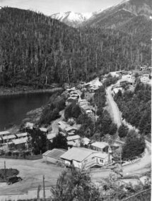
Photo - Bogong Village Township, October 8, 1946
... In 1940 Field Headquarters for the Kiewa Scheme were established at Bogong with office, workshop facilities and accommodation for workmen, staff and some families constructed. ...Kiewa Valley Historical Society Mount Beauty Information Centre 31 Bogong High Plains Rd Mt Beauty high-country In 1940 Field Headquarters for the Kiewa Scheme were established at Bogong with office, workshop facilities and accommodation for workmen, staff and some families constructed. ...In 1940 Field Headquarters for the Kiewa Scheme were established at Bogong with office, workshop facilities and accommodation for workmen, staff and some families constructed. (There had been a 'tent camp' on this site in 1939 but was destroyed by bushfires) Construction of accommodation continued until 1947. A total of 40 houses plus a hostel for single staff, post office, police station, medical centre and primary school all with water and sewerage and electricity supply. The staff hostel was known as Kiewa House and is now occupied by the Education Department. Lake Guy was named after Mr. L.T. Guy who was the Resident Engineer in charge of construction work and associated activities on the Kiewa area. He held this position from 1939 to November 1946 when he was transferred to Head Office. The Bogong Township was developed firstly as an accommodation centre (base camp) for construction workers employed under the Kiewa Hydroelectric Scheme. Due to the influx of European workers into the Township the beautification of the immediate surrounds (gardens etc.) had a distinct European flavour. This environment has been very beneficial for tourism in later years. At the completion of the scheme, in the 1960's, the village was opened to public/tourism use. Strict environmental control has not allowed for any extensive redevelopment in tourist accommodation and basically restricted it to the accommodation initially built for the construction workers. Activities such a bike riding, snow skiing, restricted horse riding and bush walking on the Alpine plains and mountains are now a viable part of the Kiewa Valley Tourist Industry. The lake is one of the many water storage reservoirs used to supply the power stations their main power to run the huge turbines generating the final product, electricityBlack and white photograph of Bogong Village which appeared in the Herald Sun newspaper on October 8, 1946. Page 13Handwritten on the back - Town of Bogong on a rugged mountain slope above Lake Guy. State Electricity Committee workers on the Kiewa Hydro Electric scheme live here in all electric homes. Stamped on the back - Copyright Not for reproduction Herald Sun Feature Service Melbourne Australiabogong village; lake guy; kiewa hydro electric scheme -
 Kiewa Valley Historical Society
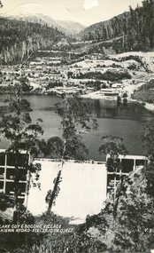
Postcard - Lake Guy and Bogong Village
... In 1940 Field Headquarters for the Kiewa Scheme were established at Bogong with office, workshop facilities and accommodation for workmen, staff and some families constructed. ...Kiewa Valley Historical Society Mount Beauty Information Centre 31 Bogong High Plains Rd Mt Beauty high-country In 1940 Field Headquarters for the Kiewa Scheme were established at Bogong with office, workshop facilities and accommodation for workmen, staff and some families constructed. ...In 1940 Field Headquarters for the Kiewa Scheme were established at Bogong with office, workshop facilities and accommodation for workmen, staff and some families constructed. (There had been a 'tent camp' on this site in 1939 but was destroyed by bushfires) Construction of accommodation continued until 1947. A total of 40 houses plus a hostel for single staff, post office, police station, medical centre and primary school all with water and sewerage and electricity supply. The staff hostel was known as Kiewa House and is now occupied by the Education Department. Lake Guy was named after Mr. L.T. Guy who was the Resident Engineer in charge of construction work and associated activities on the Kiewa area. He held this position from 1939 to November 1946 when he was transferred to Head Office. The Bogong Township was developed firstly as an accommodation centre (base camp) for construction workers employed under the Kiewa Hydroelectric Scheme. Due to the influx of European workers into the Township the beautification of the immediate surrounds (gardens etc.) had a distinct European flavour. This environment has been very beneficial for tourism in later years. At the completion of the scheme, in the 1960's, the village was opened to public/tourism use. Strict environmental control has not allowed for any extensive redevelopment in tourist accommodation and basically restricted it to the accommodation initially built for the construction workers. Activities such a bike riding, snow skiing, restricted horse riding and bush walking on the Alpine plains and mountains are now a viable part of the Kiewa Valley Tourist Industry. The lake is one of the many water storage reservoirs used to supply the power stations their main power to run the huge turbines generating the final product, electricityBlack and white photographic postcard of Lake Guy and Bogong Village. Kiewa Hydro electric Project (showing Junction Dam in front)Handwritten on the back of postcard ' Like most of our camps, this looks like something from the Canadian Rockies' Stamped on the back - Valentine's Post Card A genuine photographlake guy, bogong village, secv -
 Kiewa Valley Historical Society
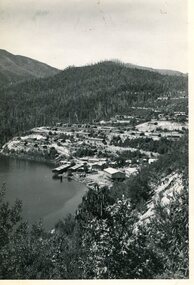
Photo - Bogong Township, September 1953
... In 1940 Field Headquarters for the Kiewa Scheme were established at Bogong with office, workshop facilities and accommodation for workmen, staff and some families constructed. ...Kiewa Valley Historical Society Mount Beauty Information Centre 31 Bogong High Plains Rd Mt Beauty high-country In 1940 Field Headquarters for the Kiewa Scheme were established at Bogong with office, workshop facilities and accommodation for workmen, staff and some families constructed. ...In 1940 Field Headquarters for the Kiewa Scheme were established at Bogong with office, workshop facilities and accommodation for workmen, staff and some families constructed. (There had been a 'tent camp' on this site in 1939 but was destroyed by bushfires) Construction of accommodation continued until 1947. A total of 40 houses plus a hostel for single staff, post office, police station, medical centre and primary school all with water and sewerage and electricity supply. The staff hostel was known as Kiewa House and is now occupied by the Education Department. Lake Guy was named after Mr. L.T. Guy who was the Resident Engineer in charge of construction work and associated activities on the Kiewa area. He held this position from 1939 to November 1946 when he was transferred to Head Office. The Bogong Township was developed firstly as an accommodation centre (base camp) for construction workers employed under the Kiewa Hydroelectric Scheme. Due to the influx of European workers into the Township the beautification of the immediate surrounds (gardens etc.) had a distinct European flavour. This environment has been very beneficial for tourism in later years. At the completion of the scheme, in the 1960's, the village was opened to public/tourism use. Strict environmental control has not allowed for any extensive redevelopment in tourist accommodation and basically restricted it to the accommodation initially built for the construction workers. Activities such a bike riding, snow skiing, restricted horse riding and bush walking on the Alpine plains and mountains are now a viable part of the Kiewa Valley Tourist Industry. The lake is one of the many water storage reservoirs used to supply the power stations their main power to run the huge turbines generating the final product, electricityBlack and white photograph of Bogong Township taken from Little Arthur fire track. September 1953Faded handwritten inscription on back - Bogong Township taken from Little Arthur fire track. Sept 1953bogong village, secv -
 Kiewa Valley Historical Society
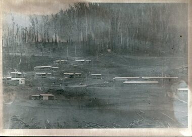
Photo - First Bogong Camp, September 1950
... In 1940 Field Headquarters for the Kiewa Scheme were established at Bogong with office, workshop facilities and accommodation for workmen, staff and some families constructed. ...Kiewa Valley Historical Society Mount Beauty Information Centre 31 Bogong High Plains Rd Mt Beauty high-country In 1940 Field Headquarters for the Kiewa Scheme were established at Bogong with office, workshop facilities and accommodation for workmen, staff and some families constructed. ...In 1940 Field Headquarters for the Kiewa Scheme were established at Bogong with office, workshop facilities and accommodation for workmen, staff and some families constructed. (There had been a 'tent camp' on this site in 1939 but was destroyed by bushfires) Construction of accommodation continued until 1947. A total of 40 houses plus a hostel for single staff, post office, police station, medical centre and primary school all with water and sewerage and electricity supply. The staff hostel was known as Kiewa House and is now occupied by the Education Department. Lake Guy was named after Mr. L.T. Guy who was the Resident Engineer in charge of construction work and associated activities on the Kiewa area. He held this position from 1939 to November 1946 when he was transferred to Head Office. The Bogong Township was developed firstly as an accommodation centre (base camp) for construction workers employed under the Kiewa Hydroelectric Scheme. Due to the influx of European workers into the Township the beautification of the immediate surrounds (gardens etc.) had a distinct European flavour. This environment has been very beneficial for tourism in later years. At the completion of the scheme, in the 1960's, the village was opened to public/tourism use. Strict environmental control has not allowed for any extensive redevelopment in tourist accommodation and basically restricted it to the accommodation initially built for the construction workers. Activities such a bike riding, snow skiing, restricted horse riding and bush walking on the Alpine plains and mountains are now a viable part of the Kiewa Valley Tourist Industry. The lake is one of the many water storage reservoirs used to supply the power stations their main power to run the huge turbines generating the final product, electricityBlack and white photo of Bogong Village. September 1950Handwritten on the back - 1st Bogong Camp. SEC Kiewa Scheme Sept 1950bogong camp, bogong village, secv -
 Kiewa Valley Historical Society
Photo - Bogong Village Township
... In 1940 Field Headquarters for the Kiewa Scheme were established at Bogong with office, workshop facilities and accommodation for workmen, staff and some families constructed. ...Kiewa Valley Historical Society Mount Beauty Information Centre 31 Bogong High Plains Rd Mt Beauty high-country In 1940 Field Headquarters for the Kiewa Scheme were established at Bogong with office, workshop facilities and accommodation for workmen, staff and some families constructed. ...In 1940 Field Headquarters for the Kiewa Scheme were established at Bogong with office, workshop facilities and accommodation for workmen, staff and some families constructed. (There had been a 'tent camp' on this site in 1939 but was destroyed by bushfires) Construction of accommodation continued until 1947. A total of 40 houses plus a hostel for single staff, post office, police station, medical centre and primary school all with water and sewerage and electricity supply. The staff hostel was known as Kiewa House and is now occupied by the Education Department. Lake Guy was named after Mr. L.T. Guy who was the Resident Engineer in charge of construction work and associated activities on the Kiewa area. He held this position from 1939 to November 1946 when he was transferred to Head Office. The Bogong Township was developed firstly as an accommodation centre (base camp) for construction workers employed under the Kiewa Hydroelectric Scheme. Due to the influx of European workers into the Township the beautification of the immediate surrounds (gardens etc.) had a distinct European flavour. This environment has been very beneficial for tourism in later years. At the completion of the scheme, in the 1960's, the village was opened to public/tourism use. Strict environmental control has not allowed for any extensive redevelopment in tourist accommodation and basically restricted it to the accommodation initially built for the construction workers. Activities such a bike riding, snow skiing, restricted horse riding and bush walking on the Alpine plains and mountains are now a viable part of the Kiewa Valley Tourist Industry. The lake is one of the many water storage reservoirs used to supply the power stations their main power to run the huge turbines generating the final product, electricityBlack and white photograph of Bogong Village from across Lake Guy. Photo mounted on buff cardbogong village, secv