Showing 171 items matching "fire maps"
-
 Warrnambool and District Historical Society Inc.
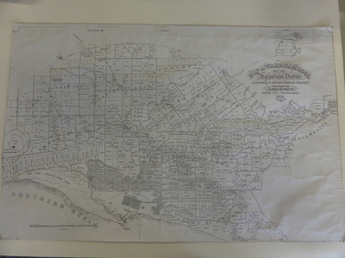
Map - Fire Maps, Region 5 Fire Control Map, 1963
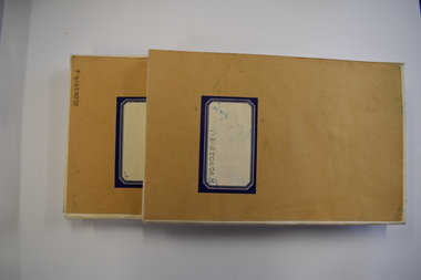
... Fire Maps...Region 5 Fire Control Map ...Fire Maps...These two maps which joined together form adjacent areas, are fire maps of portion of south west Victoria (Region 5) produced in 1963. ...The map has a white base with red and green markings and red and black printing .2 As .1 above Region 5 Fire Control Map Map Fire Maps ...Two fire maps of south west Victoria.1 This is a rectangular piece of linen folded several times to form a packet with the front part covered with a brown card. The cover has a blue and white label. The map has a white base with red and green markings and red and black printing .2 As .1 abovenon-fictionTwo fire maps of south west Victoriafire maps, warrnambool history -
 Clunes Museum
Map, 1962
... ...maps...fire....1 &.2 MAP OF BALLARAT SHIRE GROUP RURAL FIRE BRIGADES FIRE CONTROL MAP. ...Clunes Museum 36 Fraser Street enter building through Collins Place Clunes goldfields local history document maps fire brigade .1 &.2 MAP OF BALLARAT SHIRE GROUP RURAL FIRE BRIGADES FIRE CONTROL MAP. ....1 &.2 MAP OF BALLARAT SHIRE GROUP RURAL FIRE BRIGADES FIRE CONTROL MAP. COMPILED BY C. H. FENTON. (2 COPIES) DETAILING SEALED ROADS, STATE FORESTS, PINE PLANTATIONS, FOREST AREAS, RAILWAYS, BOUNDARIES, TOWNSHIP AREAS CEMETERIES, CREEKS, SWAMPS AND HOUSES.local history, document, maps, fire brigade -
 Victorian Aboriginal Corporation for Languages
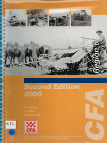
Map, Country Fire Authority, Region 6 rural directory, 2000
... Victorian regional maps...fire...Victorian Aboriginal Corporation for Languages 33 Saxon Street Brunswick melbourne Colac Lismore Cressy Lake Corangamite Camperdown Terang Cobden Peterborough Port Campbell Apollo Bay Forrest Victorian regional maps fire protection maps, b&w photographs Region 6 rural directory Map Country Fire Authority ...maps, b&w photographscolac, lismore, cressy, lake corangamite, camperdown, terang, cobden, peterborough, port campbell, apollo bay, forrest, victorian regional maps, fire protection -
 Victorian Aboriginal Corporation for Languages
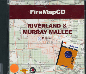
CD-ROM, Country Fire Services South Australia, FireMapCD Riverland &? Murray Mallee, 2001
... fire protection...Victorian maps...Victorian Aboriginal Corporation for Languages 33 Saxon Street Brunswick melbourne fire protection Victorian maps CD-ROM The area covered by this map is the same as the CFS Riverland & Murray Mallee Map Book. ...The area covered by this map is the same as the CFS Riverland & Murray Mallee Map Book. The area covered adjoins the Mount Lofty Ranges map book on the eastern boundary at Murray Bridge, north to Morgan and east to Renmark and the State Border. It extends southwards to join the northern boundary of the Lower South East map book at Padthaway.CD-ROMfire protection, victorian maps -
 Kew Historical Society Inc
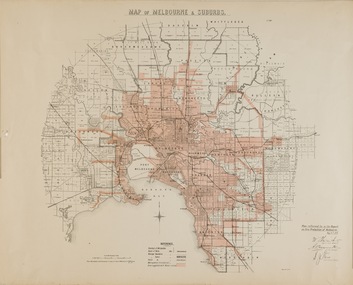
Map, Department of Lands & Survey, Map of Melbourne & Suburbs, 1899
... department of lands & survey -- historic maps...fire...Fire Brigades Board commenced service on 1 May 1891. Melbourne and its surrounding suburbs were divided into 5 sub districts each with a district superintendent and paid firefighters with additional support from paid auxiliaries. This map...Map accompanying report on fire protection of Melbourne showing those areas with water supplies tinted...."MAP OF MELBOURNE & SUBURBS / Plan referred to in the Report on Fire Protection in Melbourne, May 6th 1899 / Scale 80 Chains to 1 inch / Photo-lithographed at the Department of Lands and Survey Melbourne by T.F. ...fire brigades. While by 1910, there were 123,227 connections to Melbourne's water supply system, it is unclear in this 1899 map whether water was supplied to all built structures in the defined areas or only to fire hydrants and stand pipes. water reticulation -- melbourne (vic.) department of lands & survey -- historic maps fire brigades -- melbourne (vic.) cartography "MAP OF MELBOURNE & SUBURBS / Plan referred to in the Report on Fire Protection in Melbourne, May 6th 1899 / Scale 80 Chains to 1 inch / Photo-lithographed at the Department of Lands and Survey Melbourne by T.F. ...The Metropolitan Fire Brigades Board commenced service on 1 May 1891. Melbourne and its surrounding suburbs were divided into 5 sub districts each with a district superintendent and paid firefighters with additional support from paid auxiliaries. This map was produced on 6 May 1899 by the Department of Lands & Survey Melbourne showing the distribution of water in Melbourne for use by fire brigades. While by 1910, there were 123,227 connections to Melbourne's water supply system, it is unclear in this 1899 map whether water was supplied to all built structures in the defined areas or only to fire hydrants and stand pipes.Map accompanying report on fire protection of Melbourne showing those areas with water supplies tinted."MAP OF MELBOURNE & SUBURBS / Plan referred to in the Report on Fire Protection in Melbourne, May 6th 1899 / Scale 80 Chains to 1 inch / Photo-lithographed at the Department of Lands and Survey Melbourne by T.F. McGauran, 1891" / May 1899 No.76"water reticulation -- melbourne (vic.), department of lands & survey -- historic maps, fire brigades -- melbourne (vic.), cartography -
Glenelg Shire Council Cultural Collection
Map - Fold-out fire control map - Region 4 Victoria, n.d
... Fold-out fire control map - Region 4 Victoria...Fold-out fire control map for Region 4 - Victoria Northern sheet, includes numerical and alphabetical index....Map Fold-out fire control map - Region 4 Victoria ...Fold-out fire control map for Region 4 - Victoria Northern sheet, includes numerical and alphabetical index. -
Stawell Historical Society Inc
Map - Laminated Map, Country Fire Authority, Mt Lubra and Deep Lead Fires Estimated Perimeters 2005 - 2006, 17/3/2006
... Coloured Laminated Map of Fire Spread...fire 31/12/2005 just three weeks earlier. Two people died on Moyston / Pomonal Road. Huge stork and feed loss. CFA GIS Services Community Safety Coloured Laminated Map of Fire Spread Mt Lubra and Deep Lead Fires Estimated Perimeters 2005 - 2006 Map Laminated Map Country Fire Authority ...Huge Fire Event in Grampians started by lightning strike at Mt Lubra on 19/1/2026 during a prolonged dry period. Stawell Deep Lead fire 31/12/2005 just three weeks earlier. Two people died on Moyston / Pomonal Road. Huge stork and feed loss.Coloured Laminated Map of Fire SpreadCFA GIS Services Community Safety -
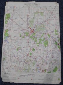 Bendigo Historical Society Inc.
Map - Bush Fire Control Map Bendigo District
... Bush Fire Control Map Bendigo District...A Bush Fire Control map is a valuable tool used by emergency services and communities to respond to respond to bushfires....Cream coloured parchment map showing roads, railway lines, telephone lines, rivers, creeks and water courses. Also marked are houses, Post Offices, Police stations, bush fire brigades, water channels, swamps, marshes, dense, medium and scattered timber, aqueducts and reservoirs. ... Bush Fire Control Map Bendigo District ...A Bush Fire Control map is a valuable tool used by emergency services and communities to respond to respond to bushfires.Cream coloured parchment map showing roads, railway lines, telephone lines, rivers, creeks and water courses. Also marked are houses, Post Offices, Police stations, bush fire brigades, water channels, swamps, marshes, dense, medium and scattered timber, aqueducts and reservoirs. Villages, districts and Towns are clearly marked. Printed in red, green, black and blue. Very clear and easy to read. Undated.bush fires, bendigo area map -
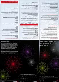 Melbourne Tram Museum
Pamphlet, Metlink, "New Year's Eve 2010 - public transport staff guide", 2009/2010
... Provides a guide to transport services, free travel, all night services, getting home, fire works map....Provides a guide to transport services, free travel, all night services, getting home, fire works map. Demonstrates an information document produced by Metlink for staff. ...Pamphlet issued by Metlink as a guide to staff working on New Year's public transport 2010. Provides a guide to transport services, free travel, all night services, getting home, fire works map.Demonstrates an information document produced by Metlink for staff.Pamplet - 6 fold DL printed on gloss paper.trams, tramways, melbourne, metlink, new years eve, public transport -
Lakes Entrance Historical Society
Map - Bogong Fire Complex Topographic Map Base Swifts Creek Sheet 8, GIS Unit Dept Primary Industry, 2003/1
... Bogong Fire Complex Topographic Map Base Swifts Creek Sheet 8...Map shows fire complex of East Gippsland names, towns, rivers and forest tracks...Lakes Entrance Historical Society 4 Marine Parade Lakes Entrance gippsland Grid represents 1,000 metre intervals of the Australian Map Grid (AMG) Australian Geoletic Datum Topography Fires Waterways Forest Roads and Streets Map shows fire complex of East Gippsland names, towns, rivers and forest tracks Map Bogong Fire Complex Topographic Map Base Swifts Creek Sheet 8 GIS Unit Dept Primary Industry ...Grid represents 1,000 metre intervals of the Australian Map Grid (AMG) Australian Geoletic DatumMap shows fire complex of East Gippsland names, towns, rivers and forest trackstopography, fires, waterways, forest, roads and streets -
Southern Sherbrooke Historical Society Inc.
Information folder - Fires 2003, 2003
... Contents: -3 photos of Omeo after the fires, by Dulcie Strahan -DSE/DPI Fire Update report dated 21st February -2 photos of fires in North-east Victoria by Andrew Aubert -3 Fire Overview maps, dated 24 January, 27 January (2 copies) and 16 February -leaflet, "Upper Murray Fires", community update, dated 12 January -copy of fire overview map, dated 16 February, with annotations -weather page, Border Mail, 8 January...Contents: -3 photos of Omeo after the fires, by Dulcie Strahan -DSE/DPI Fire Update report dated 21st February -2 photos of fires in North-east Victoria by Andrew Aubert -3 Fire Overview maps, dated 24 January, 27 January (2 copies) and 16 February -leaflet, "Upper Murray Fires", community update, dated 12 January -copy of fire overview map, dated 16 February, with annotations -weather page, Border Mail, 8 January Information folder - Fires 2003 ...Folder containing information pertaining to the 2003 Victorian, NSW & ACT bushfires. Contents: -3 photos of Omeo after the fires, by Dulcie Strahan -DSE/DPI Fire Update report dated 21st February -2 photos of fires in North-east Victoria by Andrew Aubert -3 Fire Overview maps, dated 24 January, 27 January (2 copies) and 16 February -leaflet, "Upper Murray Fires", community update, dated 12 January -copy of fire overview map, dated 16 February, with annotations -weather page, Border Mail, 8 Januarybushfires -
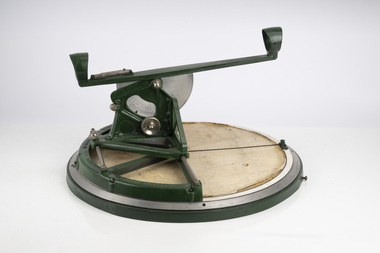 Department of Energy, Environment and Climate Action
Fire Finder
... When a fire or smoke was spotted from the tower a bearing was taken with the alidade and radioed or telephoned into the district office. It was then cross referenced with bearings from other towers on a large wall map to give a "fix" on the fire location. ...map mounted on it. The metal dial and ruler works similar to a compass. The sight tube is used to determine the bearing and elevation of the fire on the map. ...The sight tube is used to determine the bearing and elevation of the fire on the map. This Fire Finder also sometimes known as an Alidade. ...Victoria once had well over one hundred fire lookouts and firetowers. Fire lookouts, or observation posts, were often just a clearing on a hill or a vantage point, whereas firetowers were definite structures. Many were established by the Forests Commission Victoria (FCV) in the 1920s, but the network was expanded rapidly in response to recommendations of the Stretton Royal Commission after the 1939 Black Friday bushfires. When a fire or smoke was spotted from the tower a bearing was taken with the alidade and radioed or telephoned into the district office. It was then cross referenced with bearings from other towers on a large wall map to give a "fix" on the fire location. Alidades and telescopes were used in the post war period but were replaced with a much simpler map table and reference string suspended from the centre of the tower cabin. This "Fire Finder" was used in Canadian fire towers to identify the location of wildfires. The unique design was first developed by the British Columbia Forest Service (BCFS) in the early 1950s. Close examination of the map indicates that this particular Fire Finder may have been once used at Bluejoint Mountain lookout in Granby Provincial Park. This Fire Finder was a gift to Barry (Rocky) Marsden from the British Columbia Forest Service in the late 1980s in recognition of the close relationships that had been forged with the staff at the Altona Workshops over many decades. Fire Finders were originally painted black but this one was repainted green after it arrived at Altona. The BC Forest Service had a large facility where they manufactured Fire Finders and many other items of equipment, but in the 1980s it was shut down. Heavy cast iron circular object with a paper topographic map mounted on it. The metal dial and ruler works similar to a compass. The sight tube is used to determine the bearing and elevation of the fire on the map. This Fire Finder also sometimes known as an Alidade. Its a different design from the Osborne Fire Finder widely used in North American fire lookouts from the 1920s. British Columbia Forest Service. Model 62A. Serial Number 6308.bushfire -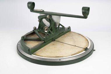
 Department of Energy, Environment and Climate Action
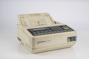
Pitney Bowes Fax Machine
... Office lunch orders went to the local Chinese takeaway by fax rather than being phoned in, while fire maps, timesheets and other urgent documents, could all be sent out straight away. ...Office lunch orders went to the local Chinese takeaway by fax rather than being phoned in, while fire maps, timesheets and other urgent documents, could all be sent out straight away. ...In the late 1970s, the must-have gadget in every forest office could be best characterised by the fax machine. Millions of people bought them because they represented a miracle. With a fax machine, you could send a sheet of paper to someone, anywhere in the country, or anywhere in the world, complete with a signature, in seconds. E-mail really didn't exist yet (except in military and university environments), so the fax machine was simply amazing. During the "golden age" of the fax machine, people faxed everything. Office lunch orders went to the local Chinese takeaway by fax rather than being phoned in, while fire maps, timesheets and other urgent documents, could all be sent out straight away. Nearly every legal document got faxed once it was signed. People also traded recipes, jokes, funny pictures and personal letters by fax rather than sending them in the snail mail. With the early machines, the output was printed onto a roll of thermal paper that regularly spewed out coils onto the floor if you weren’t watching. All this technology quickly faded, only to be superceded by the pervasive e-mail in the 1990s. But the humble fax machine gave us an early glimpse of what the office of the future would be like.Facsimile machinePitney Bowes 8050communications, forests commission victoria (fcv) -
 Department of Energy, Environment and Climate Action
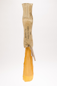
Drop Chute
... Air observers from FCV districts routinely flew during the summer months in small, fixed-wing aircraft on fire spotting missions and to map fire boundaries. The information was often needed quickly by crews on the ground or in the control centre and these small chutes were used to drop messages and maps from the reconnaissance aircraft on a low pass above a cleared area like a football field. ...Air observers from FCV districts routinely flew during the summer months in small, fixed-wing aircraft on fire spotting missions and to map fire boundaries. The information was often needed quickly by crews on the ground or in the control centre and these small chutes were used to drop messages and maps from the reconnaissance aircraft on a low pass above a cleared area like a football field. ...From the early 1960s, the Forests Commission had pre-season arrangements in place with local aeroclubs and pilots across regional Victoria. Air observers from FCV districts routinely flew during the summer months in small, fixed-wing aircraft on fire spotting missions and to map fire boundaries. The information was often needed quickly by crews on the ground or in the control centre and these small chutes were used to drop messages and maps from the reconnaissance aircraft on a low pass above a cleared area like a football field. About 3-foot long when fully extended, they had a small pouch secured with a press stud for the map or package. The chutes were made from tough canvas with a small, weighted sandbag at one end and a long yellow streamer tail on the other to help direct its fall and locating it on the ground. Drop chutes were still in common use in the 1990s, but the increased availability of helicopters combined with improved digital data transfer made drop chutes redundant. Simple, but now redundant technologyAerial drop chute"Return to Forests Comm Vic" stenciled on sidebushfire -
 Flagstaff Hill Maritime Museum and Village
Document - Map, Department of Lands & Survey, Victoria / Panmure, 1942
... map on cream paper for the Australian Army. Details include sea, waterways and land, contour lines, grid lines, names of districts, towns and roads, bridges, swamps, rail lines, cuttings, tracks, buildings (including blacksmiths), pumps, lighthouses, telegraph, telephones and electric transmission lines, and fire stations. ...map on cream paper for the Australian Army. Details include sea, waterways and land, contour lines, grid lines, names of districts, towns and roads, bridges, swamps, rail lines, cuttings, tracks, buildings (including blacksmiths), pumps, lighthouses, telegraph, telephones and electric transmission lines, and fire stations. ...This Emergency Edition of the map of Panmure, Victoria, is part of the W.R. Angus Collection. It was printed in 1942 during World War II. It is one of two maps donated to Flagstaff Hill Maritime Village by the family of Doctor William Roy Angus, who served as Surgeon Captain in the Australian Defence Department. The map was compiled for the Dept. of Army by the Dept. of Lands and Survey in Melbourne, prepared by the Australian Section of the Imperial General Staff, which was a British Government body created in 1907 to co-ordinate the defence of Britain and its Empire. It was printed by A.H.Q. Cartographic Company, Survey Corps, which was formed in 1941. The Corp changed its name to L.H.Q. Cartographic Company of Bendigo. In 1947 the name reverted back to the A.H.Q. Cartographic Company until 1955 when it became the A.H.Q. Survey Regiment. The W.R. Angus Collection includes historical medical equipment, surgical instruments and material once belonging to Dr Edward Ryan and Dr Thomas Francis Ryan, (both of Nhill, Victoria) as well as Dr Angus’ own belongings. The Collection’s history spans the medical practices of the two Doctors Ryan, from 1885-1926 plus that of Dr Angus who began practice in 1924. Dr. Angus served with the Australian Department of Defence as a Surgeon Captain during the Second World Was from 1942 to 1945. He served in Ballarat, Victoria, and in Bonegilla, N.S.W. until he suffering from a heart attack just before the war ended. ABOUT THE “W.R.ANGUS COLLECTION” - Doctor William Roy Angus M.B., B.S., Adel., 1923, F.R.C.S. Edin.,1928, was generally known as Dr Roy Angus. His working life included a position as a doctor with the Flying Doctor Service in Australia’s rural and remote areas. After many varied experiences Dr Angus and his family moved to Warrnambool in 1939 where he purchased “Birchwood,” the 1852 home and medical practice of Dr John Hunter Henderson. He was appointed on a part-time basis as Port Medical Officer in Warrnambool and held this position until the 1940’s when the government no longer required the service of a Port Medical Officer. Dr Angus was a surgeon at the Warrnambool Base Hospital 1939-1942. After further studies he commenced practice as an ophthalmologist in Warrnambool, pioneering in artificial eye improvements. He was Honorary Consultant Ophthalmologist to Warrnambool Base Hospital for 31 years and made monthly visits to Portland to perform eye surgery. Dr Angus and his wife Gladys were very involved in Warrnambool’s community with a strong interest in civic affairs. They were both involved in the creation of Flagstaff Hill Maritime Village, including the layout of the gardens. After his death on 28th March 1970 his family requested his practitioner’s plate, medical instruments and some personal belongings be displayed in the Port Medical Office surgery at Flagstaff Hill Maritime Village, and be called the “W. R. Angus Collection”. This Emergency Edition of the Map of Panmure is significant as an example of the documents prepared for the defence of Australia in World War 2. The Map is also significant for its connection between the Australian Army and the involvement of Dr WR Angus as a Surgeon in the Medical Services during World War II. The W.R. Angus Collection is significant for still being located at the site it is connected with, Doctor Angus being the last Port Medical Officer in Warrnambool. The collection of medical instruments and other equipment is culturally significant, being an historical example of medicine, administration, household equipment and clothing from late 19th to mid-20th century. Dr Angus assisted Dr Tom Ryan, a pioneer in the use of X-rays and in ocular surgery. The collection includes Dr Angus’s Army objects and is significant as an example of items issued to Doctors and Surgeons in the Medical Services of the Australian Army in World War IIMilitary map of Panmure, Victoria, Australia; part of the W.R. Angus Collection. Rectangular coloured map on cream paper for the Australian Army. Details include sea, waterways and land, contour lines, grid lines, names of districts, towns and roads, bridges, swamps, rail lines, cuttings, tracks, buildings (including blacksmiths), pumps, lighthouses, telegraph, telephones and electric transmission lines, and fire stations. The map has margin notes that include distances in miles to nearby towns. The map was compiled for the Dept. of Army by the Dept. of Lands and Survey in Melbourne, prepared by the Australian Section, Imperial General Staff and printed by A.H.Q. Cartographic Company, Melbourne in 1942. Crown Copyright Reserved. Inscriptions in red print state that it is and Emergency Edition and an Official document. An oval purple stamp includes the price.Printed in black; 'Victoria / Panmure", "No. 930 / Zone 6" Printed in red; “EMERGENCY EDITION”, “THIS MAP IS AN OFFICIAL DOCUMENT. IF FOUND, IT MUST BE HANDED / IN TO THE NEAREST MILITARY HEADQUARTERS OR POLICE STATION” Stamped: within concentric ovals (“- - - FOR SALE / PRICE 2/- / - - - - - OF THE ARMY”)flagstaff hill, warrnambool, flagstaff hill maritime museum, maritime museum, shipwreck coast, flagstaff hill maritime village, great ocean road, dr w r angus, dr ryan, warrnambool base hospital, flying doctor, surgeon captain, australian department of defence, royal australian army, world war 2, map panmure 1942, roy angus, port medical officer, nhill base hospital, military map, emergency map, military service australian army, department of army, department of lands and survey, a.h.q. cartographic company melbourne, panmure 1942, australian section, imperial general staff -
 Flagstaff Hill Maritime Museum and Village
Document - Map, Department of Lands & Survey, Victoria / Port Campbell, 1942
... map on cream paper for the Australian Army. Details include sea, waterways and land, contour lines, grid lines, names of districts, towns and roads, bridges, swamps, rail lines, cuttings, tracks, buildings (including blacksmiths), pumps, lighthouses, telegraph, telephones and electric transmission lines, and fire stations. ...map on cream paper for the Australian Army. Details include sea, waterways and land, contour lines, grid lines, names of districts, towns and roads, bridges, swamps, rail lines, cuttings, tracks, buildings (including blacksmiths), pumps, lighthouses, telegraph, telephones and electric transmission lines, and fire stations. ...This Emergency Edition of the map of Port Campbell, Victoria, is part of the W.R. Angus Collection. It was printed in 1942 during World War II. It is one of two maps donated to Flagstaff Hill Maritime Village by the family of Doctor William Roy Angus, who served as Surgeon Captain in the Australian Defence Department. The map was compiled for the Dept. of Army by the Dept. of Lands and Survey in Melbourne, prepared by the Australian Section of the Imperial General Staff, which was a British Government body created in 1907 to co-ordinate the defence of Britain and its Empire. It was printed by A.H.Q. Cartographic Company, Survey Corps, which was formed in 1941. The Corp changed its name to L.H.Q. Cartographic Company of Bendigo. In 1947 the name reverted back to the A.H.Q. Cartographic Company until 1955 when it became the A.H.Q. Survey Regiment. The W.R. Angus Collection includes historical medical equipment, surgical instruments and material once belonging to Dr Edward Ryan and Dr Thomas Francis Ryan, (both of Nhill, Victoria) as well as Dr Angus’ own belongings. The Collection’s history spans the medical practices of the two Doctors Ryan, from 1885-1926 plus that of Dr Angus who began practice in 1924. Dr Angus served with the Australian Department of Defence as a Surgeon Captain during the Second World Was from 1942 to 1945. He served in Ballarat, Victoria, and in Bonegilla, N.S.W. until he suffering from a heart attack just before the war ended. ABOUT THE “W.R.ANGUS COLLECTION” - Doctor William Roy Angus M.B., B.S., Adel., 1923, F.R.C.S. Edin.,1928, was generally known as Dr Roy Angus. His working life included a position as a doctor with the Flying Doctor Service in Australia’s rural and remote areas. After many varied experiences Dr Angus and his family moved to Warrnambool in 1939 where he purchased “Birchwood,” the 1852 home and medical practice of Dr John Hunter Henderson. He was appointed on a part-time basis as Port Medical Officer in Warrnambool and held this position until the 1940’s when the government no longer required the service of a Port Medical Officer. Dr Angus was a surgeon at the Warrnambool Base Hospital 1939-1942. After further studies he commenced practice as an ophthalmologist in Warrnambool, pioneering in artificial eye improvements. He was Honorary Consultant Ophthalmologist to Warrnambool Base Hospital for 31 years and made monthly visits to Portland to perform eye surgery. Dr Angus and his wife Gladys were very involved in Warrnambool’s community with a strong interest in civic affairs. They were both involved in the creation of Flagstaff Hill Maritime Village, including the layout of the gardens. After his death on 28th March 1970 his family requested his practitioner’s plate, medical instruments and some personal belongings be displayed in the Port Medical Office surgery at Flagstaff Hill Maritime Village, and be called the “W. R. Angus Collection”. This Emergency Edition of the Map of Port Campbell is significant as an example of the documents prepared for the defence of Australia in World War 2. The Map is also significant for its connection between the Australian Army and the involvement of Dr WR Angus as a Surgeon in the Medical Services during World War II. The W.R. Angus Collection is significant for still being located at the site it is connected with, Doctor Angus being the last Port Medical Officer in Warrnambool. The collection of medical instruments and other equipment is culturally significant, being an historical example of medicine, administration, household equipment and clothing from late 19th to mid-20th century. Dr Angus assisted Dr Tom Ryan, a pioneer in the use of X-rays and in ocular surgery. The collection includes Dr Angus’s Army objects and is significant as an example of items issued to Doctors and Surgeons in the Medical Services of the Australian Army in World War IIMilitary map of Port Campbell, Victoria, Australia; part of the W.R. Angus Collection. Rectangular coloured map on cream paper for the Australian Army. Details include sea, waterways and land, contour lines, grid lines, names of districts, towns and roads, bridges, swamps, rail lines, cuttings, tracks, buildings (including blacksmiths), pumps, lighthouses, telegraph, telephones and electric transmission lines, and fire stations. The map has margin notes that include distances in miles to nearby towns. The map was compiled for the Dept. of Army by the Dept. of Lands and Survey in Melbourne, prepared by the Australian Section, Imperial General Staff and printed by A.H.Q. Cartographic Company, Melbourne in 1942. Crown Copyright Reserved. Inscriptions in red print state that it is and Emergency Edition and an Official document. An oval purple stamp includes the price.Printed in black; 'Victoria / Port Campbell", "No. 932 / Zone 6" Printed in red; “EMERGENCY EDITION”, “THIS MAP IS AN OFFICIAL DOCUMENT. IF FOUND, IT MUST BE HANDED / IN TO THE NEAREST MILITARY HEADQUARTERS OR POLICE STATION” Stamped: within concentric ovals (“- - - FOR SALE / PRICE 2/- / - - - - - OF THE ARMY”)flagstaff hill, warrnambool, flagstaff hill maritime museum, maritime museum, shipwreck coast, flagstaff hill maritime village, great ocean road, dr w r angus, dr ryan, warrnambool base hospital, nhill base hospital, flying doctor, surgeon captain, map port campbell 1942, roy angus, port medical officer, military map, emergency map, australian department of defence, royal australian army, military service australian army, department of army, department of lands and survey, world war 2, a.h.q. cartographic company melbourne, australian section, imperial general staff, port campbell 1942 -
 Melbourne Tram Museum
Pamphlet, Yarra Trams, "New Year's Eve 2013", 2013 and 2016
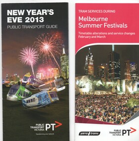
... Pamphlets - set of 2 printed in full colour on paper folded to DL size. .1 - "New Year's Eve 2013" - 8 fold, 2 half foldout - with a map showing fire works sites, locations, tram alterations, and how public transport could be used in the city. .2 - "Tram service during Melbourne Summer Festivals" - 4 fold, - issued 1/2016, detailing timetable alternations and service changes for Feb. and March - includes events - St Kilda Festival, White Night, Glenferrie Road Festival, Sydney Road festival and Moomba Parade. ...Melbourne Tram Museum 8 Wallen Road Hawthorn melbourne Trams tramways Events Melbourne Moomba Glenferrie Rd Sydney Rd St Kilda Pamphlets - set of 2 printed in full colour on paper folded to DL size. .1 - "New Year's Eve 2013" - 8 fold, 2 half foldout - with a map showing fire works sites, locations, tram alterations, and how public transport could be used in the city. .2 - "Tram service during Melbourne Summer Festivals" - 4 fold, - issued 1/2016, detailing timetable alternations and service changes for Feb. and March - includes events - St Kilda Festival, White Night, Glenferrie Road Festival, Sydney Road festival and Moomba Parade. ...Pamphlets - set of 2 printed in full colour on paper folded to DL size. .1 - "New Year's Eve 2013" - 8 fold, 2 half foldout - with a map showing fire works sites, locations, tram alterations, and how public transport could be used in the city. .2 - "Tram service during Melbourne Summer Festivals" - 4 fold, - issued 1/2016, detailing timetable alternations and service changes for Feb. and March - includes events - St Kilda Festival, White Night, Glenferrie Road Festival, Sydney Road festival and Moomba Parade. Has a calendar and maps. Also lists other major events and network upgrade and tram improvement works. Issued by Yarra Trams and the PTV.trams, tramways, events, melbourne, moomba, glenferrie rd, sydney rd, st kilda -
Bendigo Historical Society Inc.
Book - THE AUSTRALIAN BOY SCOUT DIARY 1933, 1933
... Fires. Calendars 1933, 1934. 1934 Calendar. Conventional Signs and Maps. Fires. ...Fires. Calendars 1933 1934. 1934 Calendar. Conventional Signs and Maps. Fires. ...The Australian Boy Scout Diary 1933. Inside front cover is an intimate picture of Chief & his family. With specially written notes and Sketches for Cubs, Scouts, Rovers and Scouters. Obtainable at all State Headquaters in Australia. Prepared and Published by the Victorian Section in conjuntion with the Federal Scout Council of Australia. Printed by Exchange Press Pty Ltd, 310 Spencer Street, Melbourne. Index: Boy Scouts. Bush Fires. Calendars 1933, 1934. 1934 Calendar. Conventional Signs and Maps. Fires. First Aid. Headquaters Address. Holidays. Knots, Bends and Hitches. List of Badges. Local Fixtures. Morse. Our Flag. Personal Memoranda. Pioneering. Plan of Camp. Rover Scouts. Scout Uniform. Scout Signs and Salutes. Sea Scouts. Sea Scouting - Notes on Boat Handling. Semaphore. South by the Stars. Swimming. Torch. Treatment of Snakebite. Troop Camps. Weights and Measures. Wolf Cubs. Wood Badge. Uses of Scout Staff. Inside rear cover is a sepia photo of the site of the 1933 Jamboree at Godollo, Hungary. Book is very detailed giving information on all aspects of Scout life, with sketches for knots, maps, etc. Inscriptions are on page 58: Troup or Pack - 1st Epsom Pack. Watch No. 4133033. Season Ticket No. Commonwealth acc 957. Savings No. 4729. Size in Hats: 7. Size of Boots: 5. Size of Collar 14 1/2. Size of Gloves 6 1/4. Iinscription on page 60: Books Read: In Search of Wales, Morton. Faraway, Priestly. Jock the Scot, Alice Grant Rosemary. Bernard Shaw, Frank Harris.Exchange Press Pty Ltd., Melbournebook, bendigo, scouts, the australian boy scout diary 1933. photo of chief & his family. notes and sketches for cubs, scouts, rovers and scouters. obtainable at all state headquarters in australia. published by the victorian section in conjunction with the federal scout council of australia. exchange press pty ltd, melbourne. index: boy scouts. bush fires. calendars 1933, 1934. 1934 calendar. conventional signs and maps. fires. first aid. headquarters address. holidays. knots, bends and hitches. list of badges. local fixtures. morse. our flag. personal memoranda. pioneering. plan of camp. rover scouts. scout uniform. scout signs and salutes. sea scouts. sea scouting - notes on boat handling. semaphore. south by the stars. swimming. torch. treatment of snakebite. troop camps. weights and measures. wolf cubs. wood badge. uses of scout staff. sepia photo of the site of the 1933 jamboree at godollo, hungary. information on all aspects of scout life, with sketches for knots, maps, etc. inscriptions page 58: troup or pack - 1st epsom pack. watch no. 4133033. season ticket no. commonwealth acc 957. savings no. 4729. size in hats: 7. size of boots: 5. size of collar 14 1/2. size of gloves 6 1/4. page 60: books read: in search of wales, morton. faraway, priestly. jock the scot, alice grant rosemary. bernard shaw, frank harris. -
 Warrnambool and District Historical Society Inc.
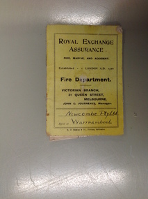
Booklet, Pay Newcombe Pty Ltd
... A small booklet relating to fire insurance offered by Royal Exchange Assurance. The schedule relates to the area as outlined on the map in red. ...Warrnambool and District Historical Society Inc. 2 Gilles Street (south of Merri St) Warrnambool great-ocean-road A small booklet relating to fire insurance offered by Royal Exchange Assurance. The schedule relates to the area as outlined on the map in red. ...A small booklet relating to fire insurance offered by Royal Exchange Assurance. The schedule relates to the area as outlined on the map in red. Newcombe PTY Ltd operated a timber mill in Warrnambool.A small item with a local social interest.Small yellow covered booklet. Black text. 9 pages with fold out map.Newcombe Pty Ltd on front cover. BCE Warrnambool Vic inside front cover.newcombe pty ltd, warrnambool, royal exchange assurance -
 Warrnambool and District Historical Society Inc.
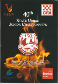
Booklet, CFA 40th Championship, 2003
... This booklet is a memento of the State Championships that were held in Warrnambool to mark 150 years of community service to Warrnambool by the Warrnambool Fire Brigade. (2013) warrnambool fire brigade state urban junior championships Front Cover: VFBV, CFA, 40th State Urban Junior Championships, February 23rd and 24th 2013, Friendly Societies Park, Hyland Street, Warrnambool, Warrnambool City Council, Powercor Australia Back Cover: Powercor Australia This is a booklet of 63 pages containing printed material, maps, advertisements and photographs. ...The Warrnambool Fire Brigade was formed in 1863. The first fire engine house was in Liebig Street and carters were required to carry water to fire scenes. In 1889 the Council built a new Fire Station on Liebig Street and Warrnambool hosted its own Annual Demonstration in 1894. In 1891 the volunteer brigade became part of the Country Fire Brigade. The Fire Station relocated to Raglan Parade in 1915 and then to Timor Street in 1961. In 1989 the Brigade moved back to Raglan Parade. This booklet is a memento of the State Championships that were held in Warrnambool to mark 150 years of community service to Warrnambool by the Warrnambool Fire Brigade. (2013)This is a booklet of 63 pages containing printed material, maps, advertisements and photographs. The back cover is red and the front cover has a black background with an image of flames and a badge with the title of the booklet. The pages are stapled.Front Cover: VFBV, CFA, 40th State Urban Junior Championships, February 23rd and 24th 2013, Friendly Societies Park, Hyland Street, Warrnambool, Warrnambool City Council, Powercor Australia Back Cover: Powercor Australia warrnambool fire brigade, state urban junior championships -
 Warrnambool and District Historical Society Inc.
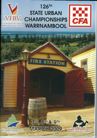
Programme - Booklet, CFA 126 Championship, 2009
... maps, advertisements, photographs and tables. The back cover is white with a Powercor Australia symbol in red and printed material. The front cover is multi-coloured with a photograph of the Fire Station at Flagstaff Hill Maritime Village. ...This booklet is a memento of the State Urban Championships that were held in Warrnambool in 2009 (Volunteer Fire Brigades Victoria and Country Fire Authority) warrnambool fire brigade state urban championships (2009) Front Cover: VFBV, Volunteer Fire Brigades Victoria, CWA, 126th State Urban Championships, 7th, 8th and 9th March 2009, Victorian State Senior Championships, Warrnambool 2009, Warrnambool City Council logo This is a booklet of 96 pages containing printed material, maps, advertisements, photographs and tables. ...The Warrnambool Fire Brigade was formed in 1863. The first fire engine house was in Liebig Street and carters were required to carry water to fire scenes. In 1889 the Council built a new Fire Station on Liebig Street and Warrnambool hosted its own Annual Demonstration in 1894. In 1891 the volunteer brigade became part of the Country Fire Brigade. The Fire Station relocated to Raglan Parade in 1915 and then to Timor Street in 1961. In 1989 the Brigade moved back to Raglan Parade. This booklet is a memento of the State Urban Championships that were held in Warrnambool in 2009 (Volunteer Fire Brigades Victoria and Country Fire Authority)This is a booklet of 96 pages containing printed material, maps, advertisements, photographs and tables. The back cover is white with a Powercor Australia symbol in red and printed material. The front cover is multi-coloured with a photograph of the Fire Station at Flagstaff Hill Maritime Village. The pages are stapled.Front Cover: VFBV, Volunteer Fire Brigades Victoria, CWA, 126th State Urban Championships, 7th, 8th and 9th March 2009, Victorian State Senior Championships, Warrnambool 2009, Warrnambool City Council logowarrnambool fire brigade, state urban championships (2009) -
 Warrnambool and District Historical Society Inc.
Map, Warrnambool 1859, Late 20th century (copy)
... map of Warrnambool and district. James Astley Bromfield was a pioneer settler in Warrnambool. He established a chemist’s shop in 1854, initially situated in Timor Street. He moved his shop to Liebig Street with a new building erected in 1875. Bromfield was a prominent resident of Warrnambool (Shire Councillor, Fire...map of Warrnambool and district. James Astley Bromfield was a pioneer settler in Warrnambool. He established a chemist’s shop in 1854, initially situated in Timor Street. He moved his shop to Liebig Street with a new building erected in 1875. Bromfield was a prominent resident of Warrnambool (Shire Councillor, Fire ...This is a copy of Bromfield’s 1856 map of Warrnambool and district. James Astley Bromfield was a pioneer settler in Warrnambool. He established a chemist’s shop in 1854, initially situated in Timor Street. He moved his shop to Liebig Street with a new building erected in 1875. Bromfield was a prominent resident of Warrnambool (Shire Councillor, Fire Brigade member, Cricket Club member, associated with horse racing etc). He was interested in preserving the history of Warrnambool and this map he produced in 1856 was an example of this interest.This is a copy only but this 1856 map is of prime importance as it contains the names of the original landowners of land in north Warrnambool and the surrounding district. It is a frequently-used resource by historians.This is a copy of a map of Warrnambool and its agricultural district published by James Astley Bromfield in 1856. The map is mounted on cardboard and has black printing on a white background. ‘Map of Warrnambool and its Agricultural District according to the Government Survey’s published by Astley Bromfield, Medical Hall, Warrnambool 1856, James Ferguson, Lithr., Melbne.’bromfield’s 1856, map, warrnambool and district -
 Bendigo Military Museum
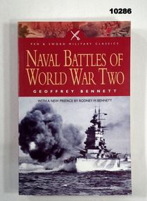
Book - BRITISH NAVY, WW2, Geoffrey Bennett, "NAVAL BATTLES OF WORLD WAR TWO", 1975
... Illustrated, black and white photographs front and back Naval vessels in Battle with guns firing. 253 pages, cut, plain, off white colour paper. Illustrated black and white photographs and maps....Illustrated, black and white photographs front and back Naval vessels in Battle with guns firing. 253 pages, cut, plain, off white colour paper. Illustrated black and white photographs and maps. ...Soft cover book. Cover - cardboard. Gold, white and black print on front, spine and back. Illustrated, black and white photographs front and back Naval vessels in Battle with guns firing. 253 pages, cut, plain, off white colour paper. Illustrated black and white photographs and maps.publication, book, navy, ww2 -
 Kiewa Valley Historical Society
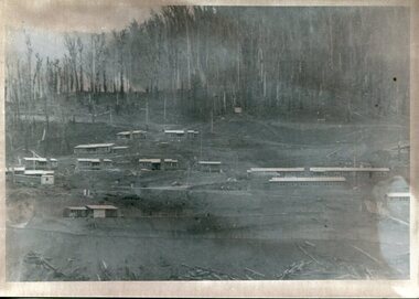
Photograph - Bogong Village (7 copies), Approx 1940
... fires. Staff residences to left. Kiewa House, General offices and test lab to the right. Hand drawn map on the back of one photo....fires. Staff residences to left. Kiewa House, General offices and test lab to the right. Hand drawn map on the back of one photo. ...In 1940 Field Headquarters for the Kiewa Scheme were established at Bogong with office, workshop facilities and accommodation for workmen, staff and some families constructed. (There had been a 'tent camp' on this site in 1939 but was destroyed by bushfires) Construction of accommodation continued until 1947. A total of 40 houses plus a hostel for single staff, post office, police station, medical centre and primary school all with water and sewerage and electricity supply. The staff hostel was known as Kiewa House and is now occupied by the Education Department. Lake Guy was named after Mr. L.T. Guy who was the Resident Engineer in charge of construction work and associated activities on the Kiewa area. He held this position from 1939 to November 1946 when he was transferred to Head Office. The Bogong Township was developed firstly as an accommodation centre (base camp) for construction workers employed under the Kiewa Hydroelectric Scheme. Due to the influx of European workers into the Township the beautification of the immediate surrounds (gardens etc.) had a distinct European flavour. This environment has been very beneficial for tourism in later years. At the completion of the scheme, in the 1960's, the village was opened to public/tourism use. Strict environmental control has not allowed for any extensive redevelopment in tourist accommodation and basically restricted it to the accommodation initially built for the construction workers. Activities such a bike riding, snow skiing, restricted horse riding and bush walking on the Alpine plains and mountains are now a viable part of the Kiewa Valley Tourist Industry. The lake is one of the many water storage reservoirs used to supply the power stations their main power to run the huge turbines generating the final product, electricity. Evidence can be seen of the 1939 bushfires.Set of 7 identical black and white photographs of Bogong Village after 1939 bush firesHandwritten on the back of one photo - Bogong Village approx. 1940, after 1939 bush fires. Staff residences to left. Kiewa House, General offices and test lab to the right. Hand drawn map on the back of one photo.bogong village, secv -
 Kiewa Valley Historical Society
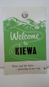
Leaflet - Kiewa, Welcome to Kiewa
... Front cover has the title in the middle, the SECV emblem at the centre top and across the bottom is a message to read the inside pages which are safety messages for driving and bush fires. The back cover has a RACV road map of Kiewa and its 'works' including the Gatehouse which was the entrance to the scheme.The map also has an insert of the main roads & nearby cities. ...Front cover has the title in the middle, the SECV emblem at the centre top and across the bottom is a message to read the inside pages which are safety messages for driving and bush fires. The back cover has a RACV road map of Kiewa and its 'works' including the Gatehouse which was the entrance to the scheme.The map also has an insert of the main roads & nearby cities. ...The State Electricity Commission of Victoria constructed the Kiewa Hydro Electric Scheme from 1938 to 1961. The Scheme included three power stations, dams, tunnels and was becoming a popular tourist destination with Falls Creek Ski field within its boundaries.This leaflet was published by the SECV to ensure all visitors to the Kiewa Hydro Electric Scheme were made aware of safety measures with regard to their driving and to bush fires. These were necessary as the area was unique with driving on mountainous roads, changeable and extreme weather and the threat of bush fires. The gatehouse existed during construction, when the SECV was in charge, as a restriction to entry to the Scheme for SECV workers and those with permission to enter. The SECV controlled the area so in case of accident, the SECV was the body to contact not eg. the police.Small white and green leaflet made from one sheet of glossy paper and folded in half. Front cover has the title in the middle, the SECV emblem at the centre top and across the bottom is a message to read the inside pages which are safety messages for driving and bush fires. The back cover has a RACV road map of Kiewa and its 'works' including the Gatehouse which was the entrance to the scheme.The map also has an insert of the main roads & nearby cities. state electricity commission of victoria; kiewa hydro electric scheme; gatehouse; safety rules; kiewa -
 Kiewa Valley Historical Society
Map - Cattlemen from Kiewa Valley
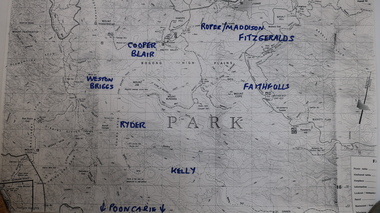
... Photocopied topographical map of part of the Alpine National Park showing 11 families areas for cattle grazing. Dated 1991/92 up to 2003 fires....Dated 1991/92 up to 2003 fires. Map - Cattlemen from Kiewa Valley ...Cattle grazing on the Bogong High Plains occurred on most summers since the 1840s. The families were farmers from the Kiewa Valley. The 2003 fires interrupted this tradition which was discontinued altogether in 2005 for environmental reasons. This tradition is still controversial.History of Cattle grazing on the Bogong High Plains and farming in the Kiewa Valley and the families that lived there.Photocopied topographical map of part of the Alpine National Park showing 11 families areas for cattle grazing. Dated 1991/92 up to 2003 fires.91/92 Until fires in 2003 Families names have been added in blue texta. They are: 'Kelly, Faithful, Weston Briggs, Ryder, Cooper, Blair, Roper, Maddison, Fitzgeralds, Hicks.'cattlemen of the kiewa valley, cattle grazing on the bogong high plains -
 Kiewa Valley Historical Society
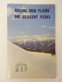
Map - Bogong High Plains & Adjacent Peaks x2, 1976
... This map identifies the mountains and peaks in the area at the time of publication. Some of the huts have since been destroyed by fire and Mt Niggerhead has since been renamed to Jaithmathang. bogong high plains. mountains. bushwalkers. walking. map. national park. recreation. cycling. tourism Blue and white cardboard folded in half containing a folded black and white map of Bogong High Plains and Adjacent Peaks with index. ...This map was produced as a result of the 'pressure from walkers' who are interested in climbing the accessible peaks on the Bogong High Plains. Places, huts and rivers are named and indexed. Contours are not given. Heights of mountains are in metres.The Bogong High Plains is a popular walking area and a National Park. This map identifies the mountains and peaks in the area at the time of publication. Some of the huts have since been destroyed by fire and Mt Niggerhead has since been renamed to Jaithmathang.Blue and white cardboard folded in half containing a folded black and white map of Bogong High Plains and Adjacent Peaks with index.bogong high plains. mountains. bushwalkers. walking. map. national park. recreation. cycling. tourism -
 Kiewa Valley Historical Society
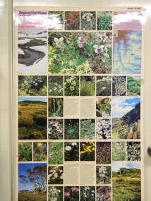
Map / Chart, Vegetation Map & Guide to Alpine Flora: Pretty Valley, 1982
... map is of interest to compare the flora in the area with times prior to 1982 and after 1982. This poster has historical and research value as it shows the flora in the pretty valley area therefore making it significant for people interested in plants. Also for those who would like to compare what plants are still in this area after 1982 and if the cattle grazing, climate change, of bush fires ...This poster shows Pretty Valley is on the Victorian High Plains where the State Electricity Commission of Victoria worked on the Kiewa Hydro Scheme. Also cattle have grazed in the area over the years. This map is of interest to compare the flora in the area with times prior to 1982 and after 1982.This poster has historical and research value as it shows the flora in the pretty valley area therefore making it significant for people interested in plants. Also for those who would like to compare what plants are still in this area after 1982 and if the cattle grazing, climate change, of bush fires have had on the environment. Thus this poster also has good interpretive capacity of these reasons. Laminated double sided vegetation map and photographic guide to Alpine flora of the Pretty Valley areapretty valley. bogong. vegetation. plants. flowers. alpine. victorian high plains. cattle grazing. s.e.c.v. -
 Kiewa Valley Historical Society
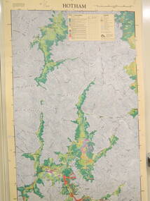
Map / Chart, Vegetation Map & Guide to Alpine Flora: Hotham, 1982
... map enables the comparison to be made of flora in other areas of the Victorian High Plains e.g.. which was previously known as the Bogong High Plains. This poster has historical and research value as it shows the flora in Mt Hotham area therefore making it significant for people interested in plants. Also for those who would like to compare what plants are still in this area after 1982 and if the cattle grazing, climate change, of bush fires ...This poster shows Mt Hotham is on the Victorian High Plains. This poster and map enables the comparison to be made of flora in other areas of the Victorian High Plains e.g.. which was previously known as the Bogong High Plains. This poster has historical and research value as it shows the flora in Mt Hotham area therefore making it significant for people interested in plants. Also for those who would like to compare what plants are still in this area after 1982 and if the cattle grazing, climate change, of bush fires have had on the environment. Thus this poster also has good interpretive capacity of these reasons.Laminated double sided vegetation map and photographic guide to Alpine flora of the Hotham area.hotham. vegetation. plants. flowers. alpine. high plains of victoria.