Showing 1091 items matching "forest district"
-
 Department of Energy, Environment and Climate Action
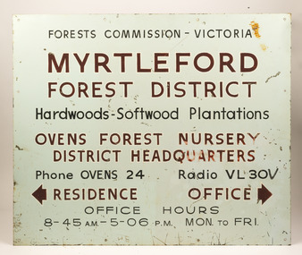
Myrtleford Forest District office sign, Included Oven's nursery
... Myrtleford Forest District office sign...This metal and enamel sign is believed to have hung outside the Myrtleford Forest District Office. It includes directions to the Ovens Nursery, Office and Residence Phone numbers, radio call signs (VL30V) and office hours are included It also makes reference to hardwood and softwoods In 1956, the new Chairman of the Forests Commission, Alf Lawrence, introduced a major restructure of the organisation to create 56 Forest Districts. ...Myrtleford Forest District office sign...Forest Signs Forests Commission Victoria (FCV) Myrtleford Forest District office sign Included Oven's nursery Myrtleford Forest District office sign ...This metal and enamel sign is believed to have hung outside the Myrtleford Forest District Office. It includes directions to the Ovens Nursery, Office and Residence Phone numbers, radio call signs (VL30V) and office hours are included It also makes reference to hardwood and softwoods In 1956, the new Chairman of the Forests Commission, Alf Lawrence, introduced a major restructure of the organisation to create 56 Forest Districts. The process included amalgamating the plantations and hardwood divisions, which had been separate and rival entities up to that time. Things remained largely unchanged for the next three decades until the early 1980s.Myrtleford Forest District office signforest signs, forests commission victoria (fcv) -
 Department of Energy, Environment and Climate Action
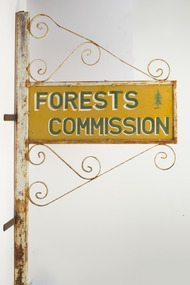
FCV Benalla Forest District office sign
... FCV Benalla Forest District office sign...This sign is believed to have hung outside the Benalla Forest District Office. The sign features a pine tree (so probably made before the 1956 restructure). ...Benalla Forest District Office Sign...The iconic Forests Commission Victoria (FCV) “two-tree” logo was designed in the early 1960s by graphic artist, Alan Rawady. Benalla Forest District Office Sign FCV Benalla Forest District office sign ...This sign is believed to have hung outside the Benalla Forest District Office. The sign features a pine tree (so probably made before the 1956 restructure). In 1956, the new Chairman of the Forests Commission, Alf Lawrence, introduced a major restructure of the organisation to create 56 Forest Districts. The process included amalgamating the plantations and hardwood divisions, which had been separate and rival entities up to that time. Things remained largely unchanged for the next three decades until the early 1980s. The iconic Forests Commission Victoria (FCV) “two-tree” logo was designed in the early 1960s by graphic artist, Alan Rawady.Benalla Forest District Office Sign -
 Lakes Entrance Historical Society
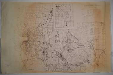
Map - Orbost Forest District, D O'Bryan, December 1977
... Orbost Forest District...Marks highways, all weather roads, dry weather roads, four wheel drive only roads. Map Orbost Forest District D O'Bryan D Freestone ...Roading maps of the forest area of Orbost. Marks highways, all weather roads, dry weather roads, four wheel drive only roads.forest, roads and streets -
Lakes Entrance Historical Society
Map - Nowa Nowa Forest District - Tildesley
... Nowa Nowa Forest District - Tildesley...Lakes Entrance Historical Society 4 Marine Parade Lakes Entrance gippsland Roads and Streets Waterways Beaches Shows roads and tracks, Nowa Nowa arm of Lake Tyers, Ninety Mile beach Map Nowa Nowa Forest District - Tildesley ...Shows roads and tracks, Nowa Nowa arm of Lake Tyers, Ninety Mile beachroads and streets, waterways, beaches -
Lakes Entrance Historical Society
Map - Nowa Nowa Forest District
... Nowa Nowa Forest District...Map Nowa Nowa Forest District ...Shows roads and tracks, towns from Benambra to Bass Strait.roads and streets, townships, waterways -
Lakes Entrance Historical Society
Map - Nowa Nowa Forest District
... Nowa Nowa Forest District...Map showing districts in Nowa Nowa forest area from Colquhoun to Murrindale...Lakes Entrance Historical Society 4 Marine Parade Lakes Entrance gippsland Forest Maps Map showing districts in Nowa Nowa forest area from Colquhoun to Murrindale Map Nowa Nowa Forest District ...Map showing districts in Nowa Nowa forest area from Colquhoun to Murrindaleforest, maps -
 Whitehorse Historical Society Inc.
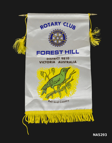
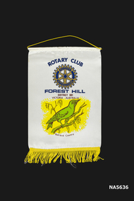
Banner - Rotary Club Forest Hill District 9810 Victoria Australia - Bell Bird Country
... Rotary Club Forest Hill District 9810 Victoria Australia - Bell Bird Country...Rotary Club, Forest Hill District 9810 Victoria Australia. Picture of green bird on branch with yellow background "Bell Bird Country". ...Banner Rotary Club Forest Hill District 9810 Victoria Australia - Bell Bird Country David - E L Products P/L ...Rotary Club - Forest Hill, Bell Bird CountryOblong cream banner gold fringe on bottom with rod on top. Rotary Club, Forest Hill District 9810 Victoria Australia. Picture of green bird on branch with yellow background "Bell Bird Country". Yellow fringe on bottom.As aboverotary club, banner, forest hill -
Creswick Campus Historical Collection - University of Melbourne
Book, Forests Commission of Victoria, Western Division. Outlines of management for all reserved forests in the Stawell Forest District, 1938
... Outlines of management for all reserved forests in the Stawell Forest District...Outlines of management for all reserved forests in the Stawell Forest District Book Forests Commission of Victoria ...This is a typed document of a Stawell Working Plan for management of reserved forests 1938Document -
 Bendigo Historical Society Inc.
Map - CAMPBELL COLLECTION: BENDIGO AND DISTRICT MAPS
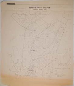
... ...forest district...Forest Commission Victoria, Bendigo Forest District, Basic information prepared 1982, scale 1:100,000. ...MAP Bendigo forest district Map. Forest Commission Victoria, Bendigo Forest District, Basic information prepared 1982, scale 1:100,000. ...Map. Forest Commission Victoria, Bendigo Forest District, Basic information prepared 1982, scale 1:100,000. Fire Prevention Strategy Plan. Mitiamo, Greater Bendigo Area, Castlemaine F.D.map, bendigo, forest district -
 Bendigo Historical Society Inc.
Map - CAMPBELL COLLECTION: BENDIGO AND DISTRICT MAPS, 1982
... ...forest district...Forest Commission Victoria, Bendigo Forest District, Greater Bendigo Area. Shire of Marong, Sailors Gully, Epsom, Borough of Eaglehawk, Jackass Flat, White Hills, California Gully, Shire of Huntly, Maiden Gully, Long Gully, North Bendigo, Bendigo East, City of Bendigo, West Bendigo, Kennington, Shire of Strathfieldsaye, Flora Hill, Quarry Hill, Golden Square, Kangaroo Flat, Spring Gully. ...MAP Bendigo forest district Map. Forest Commission Victoria, Bendigo Forest District, Greater Bendigo Area. ...Map. Forest Commission Victoria, Bendigo Forest District, Greater Bendigo Area. Shire of Marong, Sailors Gully, Epsom, Borough of Eaglehawk, Jackass Flat, White Hills, California Gully, Shire of Huntly, Maiden Gully, Long Gully, North Bendigo, Bendigo East, City of Bendigo, West Bendigo, Kennington, Shire of Strathfieldsaye, Flora Hill, Quarry Hill, Golden Square, Kangaroo Flat, Spring Gully. Prevention Strategy Plan. Base prepared 1982.map, bendigo, forest district -
Bendigo Historical Society Inc.
Map - CAMPBELL COLLECTION: BENDIGO AND DISTRICT MAPS, 1982
... ...forest district...Forest Commission Victoria, Bendigo Forest District, Sub-Plan 1 District Fire Prevention Plan, Greater Bendigo Area. ...History House 11 Mackenzie Street Bendigo goldfields MAP Bendigo forest district Map. Forest Commission Victoria, Bendigo Forest District, Sub-Plan 1 District Fire Prevention Plan, Greater Bendigo Area. ...Map. Forest Commission Victoria, Bendigo Forest District, Sub-Plan 1 District Fire Prevention Plan, Greater Bendigo Area. Prevention Strategy Plan. Shire of Marong, Shire of Huntly, Borough of Eaglehawk, Shire of Strathfieldsaye, Sailors Gully, Epsom, Jackass Flat, White Hills, California Gully, Maiden Gully, Long Gully, North Bendigo, City of Bendigo, Bendigo East, Kennington, West Bendigo, Golden Square, Quarry Hill, Flora Hill, Spring Gully, Kangaroo Flat.Base prepared 1982. (number 397 in map cupboard 1)map, bendigo, forest district -
 Otway Districts Historical Society
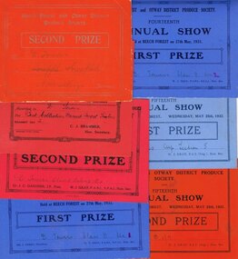
Prize, Beech Forest and Otway District Produce Society, Prizes, 1922-1932, See individual prizes
... Beech Forest and Otway District Produce Society, Prizes, 1922-1932....Beech Forest and Otway District Produce Society: (a) Second Prize, D. ...Sec. Beech Forest and Otway District Produce Society, Prizes, 1922-1932. ...Beech Forest and Otway District Produce Society: (a) Second Prize, D. Towers, for Snowflake, A.W. MacKenzie, Secretary. (b) Seventh Annual Show, 1923, Second Prize, D. Towers, for Best Collection Dressed Forest Timbers, exhibit no. 2, C.J. Brammer, Hon. Secretary. (c) Twelfth Annual Show, Second Prize, D. Towers, Class B Section 2 Ex 1, Cr. J.C. Gardner JP, Pres., W.J. Gray FABI SFAI, Hon. Sec. (d) Fourteenth Annual Show, 27 May 1931, First Prize, D. Towers, Class B Sec 1, Mr J. Perry, President, W.J. Gray FABI SFAI, Hon. Sec. (e) Fourteenth Annual Show, 27 May 1931, First Prize, D. Towers, Class B Sec 2, Mr J. Perry, President, W.J. Gray FABI SFAI, Hon. Sec. (f) Fifteenth Annual Show, 25 May 1932, First Prize, D. Towers, Cup Section 5, J.A. Perry, Pres., W.J. Gray, FCI (Eng.), Hon. Sec. (g) Fifteenth Annual Show, 25 May 1932, Second Prize, D. Towers, B 1/7, J.A. Perry, Pres., W.J. Gray FCI (Eng.), Hon. Sec.beech forest; otway; produce; prize; -
 Marysville & District Historical Society
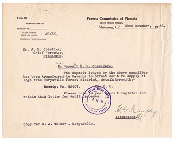
Letter (item), Forests Commission Victoria, 22-10-1956
... Chasemore which was transferred to Revenue to offset the debit regarding the supply of logs from the Marysville Forest district. The letter noted a copy had been sent to a Mr. ...Chasemore which was transferred to Revenue to offset the debit regarding the supply of logs from the Marysville Forest district. The letter noted a copy had been sent to a Mr. ...Chasemore which was transferred to Revenue to offset the debit regarding the supply of logs from the Marysville Forest district. The letter noted a copy had been sent to a Mr. ...A typed letter from the Accountant at the Forests Commission of Victoria to Mr. J.H. Cosstick, Chief Forester, of Taggerty. The letter is in regard to a deposit of 5 pounds lodged by a sawmiller, K.R. Chasemore which was transferred to Revenue to offset the debit regarding the supply of logs from the Marysville Forest district. The letter noted a copy had been sent to a Mr. W.J. Walker of Marysville and is dated October 22nd 1956. The letter has been stamped by the State Audit Office.A typed letter from the Accountant at the Forests Commission of Victoria to Mr. J.H. Cosstick, Chief Forester, of Taggerty. R. H. E. PRESENTED FOR AUDIT/ STATE AUDIT OFFICEmarysville, victoria, australia, taggerty, forests commission of victoria, mr. j.h. cosstick, k.r. chasemore, marysville forest, mr. w.j. walker, state audit office -
 Whitehorse Historical Society Inc.
Banner, Rotary International, C 1980's
... Rotary Club, Forest Hill, District 981, Victoria, Australia, Bellbird country...Whitehorse Historical Society Inc. 2-10 Deep Creek Road Mitcham melbourne Rotary Club of Forest Hill banner Banner Rotary Club Rotary Club, Forest Hill, District 981, Victoria, Australia, Bellbird country - hanging publicity banner - Fringe at base - Printed one side only - Rotary International logo prominent Banner Banner Rotary International ...Rotary Club of Forest Hill banner- hanging publicity banner - Fringe at base - Printed one side only - Rotary International logo prominentRotary Club, Forest Hill, District 981, Victoria, Australia, Bellbird countrybanner, rotary club -
 Bendigo Historical Society Inc.
Document - ANCIENT ORDER OF FORESTERS NO. 3770 COLLECTION: CORRESPONDENCE
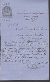
... Forest... ? Of District Arbitration Committee...History House 11 Mackenzie Street Bendigo goldfields SOCIETIES Aof correspondence Ancient Order of Foresters No. 3770 Collection - Correspondence Mechanics Institute Court King of the Forest ? Of District Arbitration Committee Letter written on blue paper with A.O.F. ...Letter written on blue paper with A.O.F. B.U.D. Emblem in top left corner and dated Nov 22/71. Letter of resignation from W. ? (signature unreadable) from his position as ? Of District Arbitration Committee in consequence of his appointment as D.C.R. and he suggests than some brother be nominated for the vacancy this evening.societies, aof, correspondence, ancient order of foresters no. 3770 collection - correspondence, mechanics institute, court king of the forest, ? of district arbitration committee -
 Warrnambool and District Historical Society Inc.
Book - Hospital Auxiliary Minute Book, Secretary of Allans Forest Red Cross Hospital Auxiliary, 1925-1930
... Forest...Warrnambool and District Hospital...Allans Forest is a small locality on the Great Ocean Road about three kilometres from the township of Allansford on the eastern fringe of Warrnambool. The Hospital Auxiliary was formed as an extension of the Allansford group in 1925 to provide support for the Warrnambool and District Hospital. ...Allans Forest Warrnambool and District Hospital Allans Forest Red Cross Allan's Forest Red Cross Hospital Auxiliary This is an exercise book with a dark red cardboard cover and black binding on the spine. ...This book contains the Minutes and financial details from the Allans Forest Red Cross Hospital Auxiliary from 1925 to 1930. Allans Forest is a small locality on the Great Ocean Road about three kilometres from the township of Allansford on the eastern fringe of Warrnambool. The Hospital Auxiliary was formed as an extension of the Allansford group in 1925 to provide support for the Warrnambool and District Hospital. The group raised funds with dances and jumble sales and donated to the hospital such items as groceries (especially home made jams and soaps), hospital linen and baby wear. The hospital would provide tins of fat for the ladies to make the soap. This exercise book is of interest as a memento of the activities of a small group in a small settlement in the Warrnambool area nearly a hundred years ago. It shows the reliance in the past of a town hospital on local groups to provide basic items such as food and linen.This is an exercise book with a dark red cardboard cover and black binding on the spine. The pages have ruled black lines and handwritten entries in ink. Some pages are blank.Allan's Forest Red Cross Hospital Auxiliaryallans forest, warrnambool and district hospital, allans forest red cross -
 Bendigo Historical Society Inc.
Document - ANCIENT ORDER OF FORESTERS NO 3770 COLLECTION: ACCOUNT
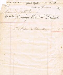
... Forest... Bendigo United District...Court King of the Forest Dr to the Bendigo United District. Item on the account is: To 1 Report & Miscellany 1/3....History House 11 Mackenzie Street Bendigo goldfields SOCIETIES Aof correspondence Ancient Order of Foresters No 3770 Collection - Account Court King of the Forest Bendigo United District Account written on white paper with printed letterhead and dated June 1877. ...Account written on white paper with printed letterhead and dated June 1877. Court King of the Forest Dr to the Bendigo United District. Item on the account is: To 1 Report & Miscellany 1/3.societies, aof, correspondence, ancient order of foresters no 3770 collection - account, court king of the forest, bendigo united district -
 Bendigo Historical Society Inc.
Document - ANCIENT ORDER OF FORESTERS NO 3770 COLLECTION: ACCOUNT/RECEIPT
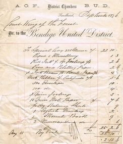
... Forest... Bendigo United District...Court King of the Forest Dr. to the Bendigo United District. Items are:- To Special levy 225 Miners @ 2/- £22/10/0, Report & Miscellany 1/3, Red Ink 1/- 1 Qr Foolscap 1/6 = 2/6, Pens and Blotting Paper 2/6, 3 Ink Erasers 1/6 Pencil & Paper 2/6 = 4/-, Neck Ribbon 3/- Certificate 2/6 = 5/6, 500 Envelopes 10/-, 100 d 4/-, 2 Quire foolscap 3/-, 10 Quire, Note? ...History House 11 Mackenzie Street Bendigo goldfields SOCIETIES Aof correspondence Ancient Order of Foresters No 3770 Collection - Account/Receipt Court King of the Forest Bendigo United District Account/receipt written on white paper with printed letterhead and dated September 1876. ...Account/receipt written on white paper with printed letterhead and dated September 1876. Court King of the Forest Dr. to the Bendigo United District. Items are:- To Special levy 225 Miners @ 2/- £22/10/0, Report & Miscellany 1/3, Red Ink 1/- 1 Qr Foolscap 1/6 = 2/6, Pens and Blotting Paper 2/6, 3 Ink Erasers 1/6 Pencil & Paper 2/6 = 4/-, Neck Ribbon 3/- Certificate 2/6 = 5/6, 500 Envelopes 10/-, 100 d 4/-, 2 Quire foolscap 3/-, 10 Quire, Note? Paper 9d 7/6, 1/2 Doz Balance Sheets 9d, 1 English D? 2/-, 1 Minute Book 9/-, 2 memorandum d? 6d. Total £25/2/6. 11th By Cash £22/10/0 leaving a balance of £2/12/6.societies, aof, correspondence, ancient order of foresters no 3770 collection - account/receipt, court king of the forest, bendigo united district -
 Department of Energy, Environment and Climate Action
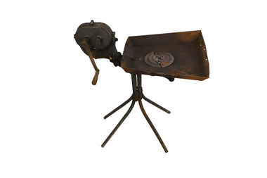
Portable Blacksmith Forge
... Portable forge used by Forests Commission districts. In an era before wide availability of hardware stores, most forest districts needed the capacity to make and mend small metal objects like planting tools and road making equipment. ...Department of Energy, Environment and Climate Action 71-79 Kyle Road Altona North Portable forge used by Forests Commission districts. In an era before wide availability of hardware stores, most forest districts needed the capacity to make and mend small metal objects like planting tools and road making equipment. ...Portable forge used by Forests Commission districts. In an era before wide availability of hardware stores, most forest districts needed the capacity to make and mend small metal objects like planting tools and road making equipment. They were also used to shoe horses These portable blacksmith forges were common, as were skilled staff and crew to use them. This forge was donated to Beechworth museum via forester, Bernie Evans. It had been repaired and originally came from the old Ovens workshop. -
 Department of Energy, Environment and Climate Action
Plain peg-tooth one-person crosscut saw
... Used in the 1930s in the Forests Commission's Erica Forest District by a rigger for cutting the top off spar trees to be used in high-lead logging. ...Department of Energy, Environment and Climate Action 71-79 Kyle Road Altona North Used in the 1930s in the Forests Commission's Erica Forest District by a rigger for cutting the top off spar trees to be used in high-lead logging. ...Used in the 1930s in the Forests Commission's Erica Forest District by a rigger for cutting the top off spar trees to be used in high-lead logging. The advent of crawler tractors after the Second World War brought about the end of high-lead logging. The saw was adopted in the 1940s by the-then Assistant Forester of Erica (James McKinty) for cutting firewood for domestic purposes; this use continued until about 1987. One-person cross cut saw with riveted handleforests commission victoria (fcv), hand tools -
Otway Districts Historical Society
Minute Book, Beech Forest Butter Factory Minute Book, 18/3/1902 - 6/2/1905, 18 March 1902
... A meeting was held in Gardner's Hall, Beech Forest, for the purposes of considering the advisability of having butter factory established in the Beech Forest district. It was eventually agreed that a butter factory should be established, that provisional directors should be appointed, and upwards of 400 shares were taken up immediately. ...Beech Forest Butter Factory Minutes Book Donated to the Otway District Historical Society Inc. by the Colac & District Family History Group Inc. 1st May 2013...Otway Districts Historical Society Cliff Young Drive Beech Forest great-ocean-road A meeting was held in Gardner's Hall, Beech Forest, for the purposes of considering the advisability of having butter factory established in the Beech Forest district. ...A meeting was held in Gardner's Hall, Beech Forest, for the purposes of considering the advisability of having butter factory established in the Beech Forest district. It was eventually agreed that a butter factory should be established, that provisional directors should be appointed, and upwards of 400 shares were taken up immediately. A second meeting was held on 20 May 1902 of about 40 dairymen. The meeting became a meeting of shareholders resolving to expedite the registration of the company and other preliminary matters. The election of directors then took place. Another meeting of shareholders held on the 15 July 1902 resolved to purchase a property and have the by-laws accepted. An Extraordinary General Meeting was held on 6 August 1902 to confirm all the resolutions passed by the Board.A ledger containing the records of the Beech Forest Butter Factory Minute Book from 18 March, 1902, the date the Butter Factory starts, until 6 February, 1905.Beech Forest Butter Factory Minutes Book Donated to the Otway District Historical Society Inc. by the Colac & District Family History Group Inc. 1st May 2013beech forest; butter, factory, 1902, 1905, minute book, -
 Department of Energy, Environment and Climate Action
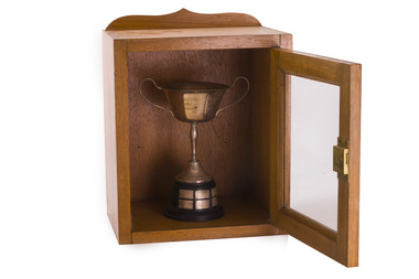
Award - Charles Watson Perpetual Trophy, North east division annual fire school - 1954 - 1962
... Fire schools were an important pre-summer program for all Forests Commission staff and crews They were designed as refresher courses for existing staff and training of new staff on how to use pumps and hoses FCV Forest Divisions were made up of separate forest inter-district and competitions were held. The award was displayed prominently in either the winning district or kept in the divisional office Charles Watson was appointed as the Divisional Forester at Wangaratta in 1949, before retiring in 1960....Department of Energy, Environment and Climate Action 71-79 Kyle Road Altona North Fire schools were an important pre-summer program for all Forests Commission staff and crews They were designed as refresher courses for existing staff and training of new staff on how to use pumps and hoses FCV Forest Divisions were made up of separate forest inter-district and competitions were held. The award was displayed prominently in either the winning district or kept in the divisional office Charles Watson was appointed as the Divisional Forester at Wangaratta in 1949, before retiring in 1960. ...Fire schools were an important pre-summer program for all Forests Commission staff and crews They were designed as refresher courses for existing staff and training of new staff on how to use pumps and hoses FCV Forest Divisions were made up of separate forest inter-district and competitions were held. The award was displayed prominently in either the winning district or kept in the divisional office Charles Watson was appointed as the Divisional Forester at Wangaratta in 1949, before retiring in 1960.Silver cup on stand in wooden display case with glass frontNames of winners 1954 - F Halloran & B Curren - Upper Ovens 1955 - L J Mitchell & J D Hallen - Ovens ? 1957 - K R O'Kane & R E Warren - Upper Murray 1958 - A P Davis & D G Craig - Delatite 1959 - K N Gibson & R W Handmer - Mansfield 1960 - L Reid & I F McLaughlin - Benalla 1962 - P Breen & G Treloar - Bright forests commission victoria (fcv) -
 Department of Energy, Environment and Climate Action
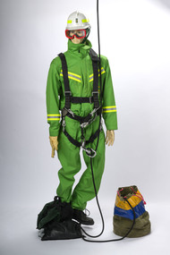
Rappel model with protective equipment, harness and rope drop bag
... During the 1983 bushfires, a specially trained and equipped FCV crew rappelled by rope from a hovering NSCA helicopter to suppress a small fire in remote terrain in the Orbost Forest District. ...During the 1983 bushfires, a specially trained and equipped FCV crew rappelled by rope from a hovering NSCA helicopter to suppress a small fire in remote terrain in the Orbost Forest District. Forests Commission Victoria (FCV) Bushfire Bushfire Aviation Safety equipment Rappel model with protective equipment, harness and rope drop bag Rappel model with protective equipment, harness and rope drop bag ...Based on the earlier successful tests with the RAAF Dragonfly in 1948-49, together with the effective use of aircraft during the extensive Gippsland bushfires in March 1965, the Forests Commission took the plunge and contracted its own dedicated Bell 47G in the summer of 1965-66. This was an Australian first for any forest or bushfire agency. Rappelling trials at Snowy Plains and Tallangatta soon followed, which led to operations based at Heyfield with a two-man crew to quickly attack small fires in remote locations. The Heyfield rappel crew was another Australian first and remained in place for the following two fire seasons but lapsed after concerns from the Civil Aviation Safety Authority (CASA) about the stability of the small and underpowered Bell 47G. Later in 1982, after nearly 18 years absence, the Commission recommenced rappelling operations using larger and more powerful National Safety Council (NSCA) Bell 212 and Bell 412 helicopters based in Sale, Gippsland. During the 1983 bushfires, a specially trained and equipped FCV crew rappelled by rope from a hovering NSCA helicopter to suppress a small fire in remote terrain in the Orbost Forest District. Rappel model with protective equipment, harness and rope drop bagforests commission victoria (fcv), bushfire, bushfire aviation, safety equipment -
 Department of Energy, Environment and Climate Action
Helibox, Cardboard food delivery box, Early 1960s
... The cardboard boxes were so designed that they could be flat-packed for delivery and storage at the Forest Districts. They were suitable for supplies weighing less than 9 kg and best dropped from about 300 feet. ...The cardboard boxes were so designed that they could be flat-packed for delivery and storage at the Forest Districts. They were suitable for supplies weighing less than 9 kg and best dropped from about 300 feet. ...The successful dropping of supplies to remote fire crews involved a great deal of experimentation. The basic concept was brought back from America by then Chief Fire Protection Officer, Ted Gill. From this concept, in 1964, Athol Hodgson, the Forests Commission's Fire Research Officer, experimented with various types before arriving at this large, heavy-duty corrugated cardboard container which employed fold-out fins. Athol's experiments showed that the container, called the 'helibox', must be able to free-drop for some 200 feet (66 metres) before the fins, which had a large angle of attack, could open and cause the container to rotate, so slowing the rate of descent. The cardboard boxes were so designed that they could be flat-packed for delivery and storage at the Forest Districts. They were suitable for supplies weighing less than 9 kg and best dropped from about 300 feet. It was found that even eggs survived the fall when they were packed inside loaves of bread. The helibox became a standard technique for delivery of supplies from fixed-wing aircraft and was used extensively in the Corryong, Tallangatta, Mansfield and Tinambra areas where the alternative was to back-pack supplies into fire crews in the mountainous terrain. The technique was adopted Australia-wide. The increasing availability of helicopters and extensive network of four-wheel-drive tracks eventually made the helibox redundant. Unique to Victoria but adopted across Australia.Large cardboard box with 'fins' that caused it to rotate when dropped from an aircraft. Fins held in place by means of office type string 'Ty-Tite' fasteners.bushfire, forests commission victoria (fcv) -
 Department of Energy, Environment and Climate Action
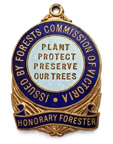
Badge - Honorary Forester badge
... Forests Act of 1918. Many organisations actively interested in forestry were invited to nominate suitable persons. The first appointments were made in 1924 and, by 1939, there were about 350 Honorary Foresters in the State. Each was issued with this distinguishing badge and given the authority to act, and were requested to cooperate with District...Forests Act of 1918. Many organisations actively interested in forestry were invited to nominate suitable persons. The first appointments were made in 1924 and, by 1939, there were about 350 Honorary Foresters in the State. Each was issued with this distinguishing badge and given the authority to act, and were requested to cooperate with District ...A system of appointment of responsible members of the general public as Honorary Foresters was enabled initially under the Forests Act of 1918. Many organisations actively interested in forestry were invited to nominate suitable persons. The first appointments were made in 1924 and, by 1939, there were about 350 Honorary Foresters in the State. Each was issued with this distinguishing badge and given the authority to act, and were requested to cooperate with District Forest Officers in the protection of State forests.brass badges with loops for suspension by ribbon; two-toned blue enamel background to letteringObverse: ISSUED BY FORESTS COMMISSION OF VICTORIA; PLANT PROTECT PRESERVE OUR TREES; HONORARY FORESTER Reverse (badge1): 116; P.J. KING MELB Reverse (badge2): 886; P.J. KING MELB -
 Bendigo Historical Society Inc.
Document - ANCIENT ORDER OF FORESTERS NO. 3770 COLLECTION: CORRESPONDENCE
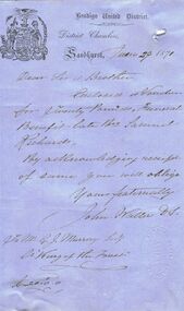
... District... Samuel Richards... John Waller... G J Murray... Cr King of the Forest...Murray, Secr, Cr King of the Forest. Has Bendigo United District A.O.F. impression stamp (oval shape)....Murray, Secr, Cr King of the Forest. Has Bendigo United District A.O.F. impression stamp (oval shape). ...Letter dated June 29 1871, with printed letterhead and emblem. Letter mentions that Vouchers for Twenty Pounds, Funeral Benefits for late Br Samuel Richards. By acknowledging of same you will oblige. Signed by John Waller DS. To G. J. Murray, Secr, Cr King of the Forest. Has Bendigo United District A.O.F. impression stamp (oval shape).societies, aof, correspondence, ancient order of foresters no. 3770 collection - correspondence, bendigo united district, samuel richards, john waller, g j murray, cr king of the forest -
Bendigo Historical Society Inc.
Map - CAMPBELL COLLECTION: BENDIGO AND DISTRICT MAPS
... Management Blocks Bendigo, Forest Commission Victoria. The district has been subdivided into 8 master blocks incorporarting existing forest blocks and a register for each management block.01 Sandhurst; 02 Leichardt; 03 Whipsick; 04 Sugarloaf; 05 Brolga; 06 Mitiamo; 07 Dingee; 08 Lockington. ...History House 11 Mackenzie Street Bendigo goldfields MAP Bendigo forest blocks G.H.Jennings District Forester Map. Management Blocks Bendigo, Forest Commission Victoria. ...Map. Management Blocks Bendigo, Forest Commission Victoria. The district has been subdivided into 8 master blocks incorporarting existing forest blocks and a register for each management block.01 Sandhurst; 02 Leichardt; 03 Whipsick; 04 Sugarloaf; 05 Brolga; 06 Mitiamo; 07 Dingee; 08 Lockington. Forest Produce Licence (number 392 in map cupboard 1)G.H.Jennings District Forestermap, bendigo, forest blocks -
 Bendigo Historical Society Inc.
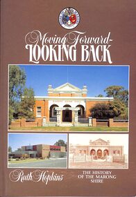
Book - "Moving Forward - Looking Back", 1985
... Marong shire had a mixture of agricultural districts, eucalypt forests and mining localities. There was gold mining at Maiden Gully, Wilson’s Reef near Marong, Neilborough and Sebastian. ...Marong shire had a mixture of agricultural districts, eucalypt forests and mining localities. There was gold mining at Maiden Gully, Wilson’s Reef near Marong, Neilborough and Sebastian. ...Marong Shire (1864-1994), immediately west and north of Bendigo, was proclaimed on 23 December 1864. Its western boundary was the Loddon River and its eastern boundary enclosed Kangaroo Flat which after World War II had a population of about 1000 persons. By 1990 Kangaroo Flat had an estimated population of about 10,000, thus giving the shire a pronounced urban component. Accordingly, the shire was proclaimed a rural city on 1 October 1990. Marong shire had a mixture of agricultural districts, eucalypt forests and mining localities. There was gold mining at Maiden Gully, Wilson’s Reef near Marong, Neilborough and Sebastian. The mining borough of Raywood was united with the shire on 1 October 1915. Lockwood was the shire’s administrative centre until 1908, when the centre was transferred to Marong. Marong municipality was served by two railway lines from Bendigo: north-westerly to Bridgwater-on-Loddon (1876) and northerly to Raywood and Pyramid Hill (1882). The Calder and Loddon Valley highways run generally north-west through the former municipality, through undulating to flat terrain, suitable for cereal growing and grazing. South of the Calder Highway the land is undulating to gullied. At the far south-west the Laanecoorie Reservoir lies on the Loddon River. In 1994 Marong rural city, with an area of 1489 sq km, had about 9000 cattle, 240,000 sheep and lambs and 11,000 pigs. About 6800 tonnes of barley and 27,000 tonnes of wheat were harvested. On 7 April 1994, Marong rural city was united with Bendigo city, Eaglehawk borough and Huntly and Strathfieldsaye shires to form Greater Bendigo city."Moving Forward - Looking Back" by Ruth Hopkins. Published for the Shire of Morong, Victoria 150th Anniversary Committee, by C G P Printing and Publishing, Bendigo. Printed in 1985. Soft cover book. Front cover is dark fawn brown in color with three photographs inset. Title and author's name in white on front cover and spine. Shire of Marong crest on front cover. Contains map of the then Marong Shire. Covers the history of Marong Shire. 119 pp. Contains both text and black and white images. ISBN 0949248037. shire, marong shire, kangaroo flat, marong -
 Warrnambool and District Historical Society Inc.
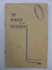
Booklet, Terang Express, The Border of the Heytesbury, 1937
... Forest area at the end of the 19th century. There are accounts of the bushland, the school and the people in the area. Alice Goldstraw (d. 1967) was the daughter of George and Robina Goldstraw who were pioneer farmers in the Cudgee area. The Goldstraw families were prominent in the early history of Warrnambool and district...Warrnambool and District Historical Society Inc. 2 Gilles Street (south of Merri St) Warrnambool great-ocean-road This book has been written by Alice Goldstraw in 1937. It is a fine history of life in the Naringal/Cudgee/Heytesbury Forest ...This book has been written by Alice Goldstraw in 1937. It is a fine history of life in the Naringal/Cudgee/Heytesbury Forest area at the end of the 19th century. There are accounts of the bushland, the school and the people in the area. Alice Goldstraw (d. 1967) was the daughter of George and Robina Goldstraw who were pioneer farmers in the Cudgee area. The Goldstraw families were prominent in the early history of Warrnambool and district, especially as timber millers and sawyers. This book is of considerable importance as it is a rare copy of ‘The Border of the Heytesbury’ written by Alice Goldstraw. It provides a wealth of material for researchers. An index to the book has been compiled by the Warrnambool and District Historical Society. This is a soft cover booklet of 34 pages. It has a buff-coloured cover with black printing and blue lines on the front cover. There is also a Warrnambool & District Historical Society stamp on the front cover. There are eleven chapters on ‘The Border of the Heytesbury’ and one chapter on ‘Some People in the Heytesbury’. The printed pages are divided into two columns. The pages have been stapled but the staples have been removed.Enid Suggetthistory of cudgee/naringal/heytesbury forest area, history of warrnambool, alice goldstraw, cudgee, naringal, heytesbury forest -
 Warrnambool and District Historical Society Inc.
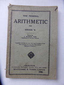
Book, The Federal Arithmetic, Early 20th century
... Warrnambool and District Historical Society Inc. 2 Gilles Street (south of Merri St) Warrnambool great-ocean-road This is a Grade V Arithmetic book used by George Bonnett at Allans Forest School. ...This is a Grade V Arithmetic book used by George Bonnett at Allans Forest School. The Bonnett family farmed in the Mepunga area on the Childers Cove Road. The Allans Forest State School, number 1086, was established in 1871 and closed in 1993. The first Head Teacher was Mr Bradhurst. The school closed in 1903 and re-opened in 1905 as a half-time school with Mepunga East and in 1908 it resumed as a full time school. This book is significant because it was used by George Bonnett at the Allans Forest State School and is a memento of both the Bonnett family of Mepunga and the Allans Forest State School, a school no longer existing. It is also of antiquarian interest as an example of arithmetic school text books used early in the 20th century. This is soft cover book of 128 pages. The cover is grey with black print and black lines around the edges of the front cover. The book has a prefatory note, arithmetical exercises and advertisements for other school text books published by Whitcombe and Tombs. The cover is torn and soiled and partly ripped away. There is handwriting in black ink on the first page.‘George H. Bonnett, Allans Forest State School’bonnett family, mepunga, allans forest state school, warrnambool history