Showing 104 items matching "gippsland floods"
-
 Orbost & District Historical Society
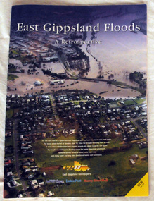
pictorial magazine, East Gippsland Floods A Retrospective, 2007
... East Gippsland Floods A Retrospective...floods-east gippsland disasters-flood...This magazine pictorial was produced by East Gippsland News as a record of the Floods of June/July 2007....A magazine pictorial with photos of the June/July East Gippsland flood event in 2007. Photos are of Bairnsdale, Lakes Entrance, Lake Tyers, Orbost, Linenow, Metung, Eagle Point and Paynesville....Orbost & District Historical Society Ruskin Street Orbost gippsland This magazine pictorial was produced by East Gippsland News as a record of the Floods of June/July 2007. This is a contemporary record of a local event. floods-east gippsland disasters-flood A magazine pictorial with photos of the June/July East Gippsland flood event in 2007. ...This magazine pictorial was produced by East Gippsland News as a record of the Floods of June/July 2007.This is a contemporary record of a local event.A magazine pictorial with photos of the June/July East Gippsland flood event in 2007. Photos are of Bairnsdale, Lakes Entrance, Lake Tyers, Orbost, Linenow, Metung, Eagle Point and Paynesville.floods-east gippsland disasters-flood -
 Lakes Entrance Historical Society
Photograph - Tambo Valley East Gippsland Floods 1998, Lakes Post Newspaper, 1/06/1999 12:00:00 AM
... Tambo Valley East Gippsland Floods 1998,...Colour photograph of Whelans truck being loaded with rock and gravel during flood response program in the Tambo Valley East Gippsland Victoria...Floods Natural Disasters Colour photograph of Whelans truck being loaded with rock and gravel during flood response program in the Tambo Valley East Gippsland Victoria Photograph Tambo Valley East Gippsland Floods 1998, Lakes Post Newspaper ...Colour photograph of Whelans truck being loaded with rock and gravel during flood response program in the Tambo Valley East Gippsland Victoriafloods, natural disasters -
 Lakes Entrance Historical Society
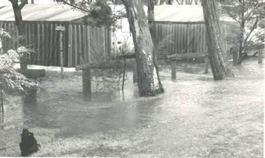
Photograph, Bairnsdale Advertiser, East Gippsland Floods 1988, 1/11/1988 12:00:00 AM
... East Gippsland Floods 1988...Black and white photograph showing flood waters flowing through a camping park with two large tents and a caravan surrounded East Gippsland Victoria...Lakes Entrance Historical Society 4 Marine Parade Lakes Entrance gippsland Also two other black and white photographs of raging flood waters during same flood event. 04933.1 10 x 17 cm and 04933.2 18 x 24.5 cm Oil and Gas Industry Black and white photograph showing flood waters flowing through a camping park with two large tents and a caravan surrounded East Gippsland Victoria East Gippsland Floods 1988 Photograph Bairnsdale Advertiser ...Also two other black and white photographs of raging flood waters during same flood event. 04933.1 10 x 17 cm and 04933.2 18 x 24.5 cmBlack and white photograph showing flood waters flowing through a camping park with two large tents and a caravan surrounded East Gippsland Victoriaoil and gas industry -
 Orbost & District Historical Society
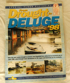
pictorial magazine, From Drought to Deluge '98, 1998
... flood-1998 flood-east gippsland disaster-floods...This magazine cost $2.50 and was produced to support the East Gippsland Red Cross Flood Appeal. Following heavy rain in East Gippsland in June, 1998, major flooding occurred in the Mitchell, Nicholson, Tambo, Snowy, Brodribb and Bemm Rivers. ...This magazine is a contemporary record of a significant local event. flood-1998 flood-east gippsland disaster-floods Two copies of a magazine pictorial of the floods of 1998. ...This magazine cost $2.50 and was produced to support the East Gippsland Red Cross Flood Appeal. Following heavy rain in East Gippsland in June, 1998, major flooding occurred in the Mitchell, Nicholson, Tambo, Snowy, Brodribb and Bemm Rivers. Other streams in the region also experienced high flows during this time. Probably the most severe direct impacts of the floods were to the rural sector.This magazine is a contemporary record of a significant local event.Two copies of a magazine pictorial of the floods of 1998. Photos are black and white. They are of Bairnsdale, Orbost, Lakes Entrance, Raymond Island, Bemm River, Bruthen , Tambo and Cabbage Tree. flood-1998 flood-east gippsland disaster-floods -
 4th/19th Prince of Wales's Light Horse Regiment Unit History Room
Regimental Scrap Book: 1990-1999, 2009
... ...gippsland floods...Chief of General Staff Commendation to A Squadron 4/19 PWLH for assistance with flood emergency in Gippsland April 1990. Meritorious Unit Commendation to Prince of Wales Light Horse Troop while attached to 173 US Airborne Brigade, South Vietnam 1965/66. ...4th/19th Prince of Wales's Light Horse Regiment Unit History Room 4/19 PWLH Regiment, Building 78 Simpson Barracks Macleod melbourne ceremonial training vietnam war history 4 19 prince of wales s light horse freedom of city melbourne freedom of city traralgon traralgon army depot commendations gippsland floods Archival quality A3 loose leaf slip case containing memorabilia documents, cuttings and photos about the Regiment for the period 1990-1999. ...Archival quality A3 loose leaf slip case containing memorabilia documents, cuttings and photos about the Regiment for the period 1990-1999. Contents include:Training, Ceremonial, social activities. Hansard 18 Oct 1990 re future of the Regiment. Threats to the Regiment. Chief of General Staff Commendation to A Squadron 4/19 PWLH for assistance with flood emergency in Gippsland April 1990. Meritorious Unit Commendation to Prince of Wales Light Horse Troop while attached to 173 US Airborne Brigade, South Vietnam 1965/66. Freedom of City of Melbourne May 1992. 50th Birthday of Regiment. Closure of Traralgon Depot 1998.ceremonial, training, vietnam war, history 4 19 prince of wales s light horse, freedom of city melbourne, freedom of city traralgon, traralgon army depot, commendations, gippsland floods -
 Orbost & District Historical Society
black and white photographs, second half 20th century
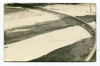
... Orbost-Railway East-Gippsland -Railway Orbost-floods...flood damage to the viaduct across the Snowy River flats. Two men are driving a dozer. This item is associated with the history of the Orbost-Bairnsdale railway line and therefore reflects the role that the rail line played in the social and economic history of Orbost. Orbost-Railway East-Gippsland ...3154.1 is a postcard of the Orbost viaduct over the flooded Snowy River flats. 4153.2 is of a goods train on the viaduct. 3154.3 is of a loaded goods train with the driver at the window. Two men are standing on the plate and there are two workers below where there is some water and flood debris. 3154.4 is of amachine moving flood debris on the rail line. 3154.5 shows flood damage to the viaduct across the Snowy River flats. Two men are driving a dozer.This item is associated with the history of the Orbost-Bairnsdale railway line and therefore reflects the role that the rail line played in the social and economic history of Orbost.Five black / white photographs associated with the Orbost railway line during a flood.orbost-railway east-gippsland -railway orbost-floods -
 Lakes Entrance Historical Society
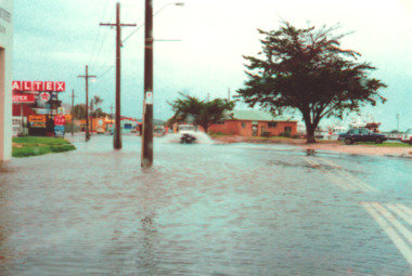
Photograph, Lakes Post Newspaper, Esplanade floods, Lakes Entrance Victoria 1998, 1/06/1998 12:00:00 AM
... Floods...Gippsland Lakes...Floods Gippsland Lakes Natural Disasters Colour photograph taken during floods of part of Esplanade Lakes Entrance Victoria Esplanade floods, Lakes Entrance Victoria 1998 Photograph Lakes Post Newspaper ...Colour photograph taken during floods of part of Esplanade Lakes Entrance Victoriafloods, gippsland lakes, natural disasters -
Lakes Entrance Historical Society
Book, Glenvale School Committee, From Fire to Flood, 2007
... A pictorial record which graphically represents the devastation caused by fire and flood in Gippsland during 2006-2007....Lakes Entrance Historical Society 4 Marine Parade Lakes Entrance gippsland Natural Disasters A pictorial record which graphically represents the devastation caused by fire and flood in Gippsland during 2006-2007. ...A pictorial record which graphically represents the devastation caused by fire and flood in Gippsland during 2006-2007.natural disasters -
 Orbost & District Historical Society
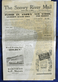
newspaper, 15.2.1950
... The paper is still being produced by the fourth generation of the Yeates family as part of East Gippsland Newspapers. The flood in 1950 was a significant Orbost event. ...The paper is still being produced by the fourth generation of the Yeates family as part of East Gippsland Newspapers. The flood in 1950 was a significant Orbost event. ...The Snowy River Mail is a weekly newspaper published in Orbost in the Shire of East Gippsland, Victoria, Australia. Previously published as The Snowy River mail and Tambo and Croajingolong gazette from 1890 to 1911. The Gippsland Courier merged with the Snowy River Mail when proprietor Lachlan Ross moved to Orbost in 1910. In 1999 the paper was acquired by the Yeates family when the Hollins family retired from the newspapers business. The paper is still being produced by the fourth generation of the Yeates family as part of East Gippsland Newspapers. The flood in 1950 was a significant Orbost event. This newspaper is a contemporary record of a significant local events.A Snowy River Mail newspaper dated 15,.2.1950. It contains news articles and advertisements in black/white print. There is an artcle about the Orbost floods.newspaper snowy-river-mail flood-1950-orbost -
 Orbost & District Historical Society
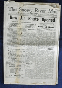
newspaper, Snowy River Mail, 29.3.1950
... The paper is still being produced by the fourth generation of the Yeates family as part of East Gippsland Newspapers. The 1950 flood was a significant event in Orbost. ...The paper is still being produced by the fourth generation of the Yeates family as part of East Gippsland Newspapers. The 1950 flood was a significant event in Orbost. ...The Snowy River Mail is a weekly newspaper published in Orbost in the Shire of East Gippsland, Victoria, Australia. Previously published as The Snowy River mail and Tambo and Croajingolong gazette from 1890 to 1911. The Gippsland Courier merged with the Snowy River Mail when proprietor Lachlan Ross moved to Orbost in 1910. In 1999 the paper was acquired by the Yeates family when the Hollins family retired from the newspapers business. The paper is still being produced by the fourth generation of the Yeates family as part of East Gippsland Newspapers. The 1950 flood was a significant event in Orbost. This newspaper is a contemporary record of a significant local events.A Snowy River Mail newspaper dated 29.3.1950. It contains news articles and advertisements in black/white print. it contains an article on the flood at that time.snowy-river-mail 1950-flood newspaper -
 Warrnambool and District Historical Society Inc.
Document - Calendar 2021, 2020
... Included are Wollaston Bridge, January 2020 Gippsland bushfire smoke in Warrnambool streets, Hopkins River, Proudfoots Boathouse, Merri River School, Deakin University, Hopkins River boat ramp, Warrnambool breakwater, Middle Island Warrnambool, Hopkins Falls, Merri River flood at Wollaston Bridge, Warrnambool War Memorial, private house...Included are Wollaston Bridge, January 2020 Gippsland bushfire smoke in Warrnambool streets, Hopkins River, Proudfoots Boathouse, Merri River School, Deakin University, Hopkins River boat ramp, Warrnambool breakwater, Middle Island Warrnambool, Hopkins Falls, Merri River flood at Wollaston Bridge, Warrnambool War Memorial, private house bushfires warrnambool hopkins river proudfoots boathouse schools education deakin university bridges wollaston bridge war memorials harbours 2021, Merry Christmas and a Happy New Year A4 size calendar, with wire binding, white background with coloured image of Wollaston Bridge and text in black. ...This calendar has local Warrnambool scenes taken during 2020, featuring a different image each month. Included are Wollaston Bridge, January 2020 Gippsland bushfire smoke in Warrnambool streets, Hopkins River, Proudfoots Boathouse, Merri River School, Deakin University, Hopkins River boat ramp, Warrnambool breakwater, Middle Island Warrnambool, Hopkins Falls, Merri River flood at Wollaston Bridge, Warrnambool War Memorial, private houseA4 size calendar, with wire binding, white background with coloured image of Wollaston Bridge and text in black.2021, Merry Christmas and a Happy New Yearbushfires, warrnambool, hopkins river, proudfoots boathouse, schools, education, deakin university, bridges, wollaston bridge, war memorials, harbours -
 Orbost & District Historical Society
plan, December 1968
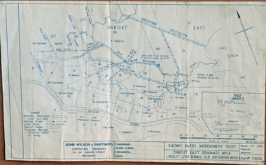
... The meander was cut-off in 1931, as part of the Orbost East Drainage Scheme and further developed after 1934 floods and again in the early 1950s when levee banks and a regulator were constructed. (ref. East Gippsland Catchment Management)...gippsland Brodribb floodplain regularly inundated in the late 1800s and early 1900s. Works included: clearing the river channel and blocking ‘gulches’. The meander was cut-off in 1931, as part of the Orbost East Drainage Scheme and further developed after 1934 floods and again in the early 1950s when levee banks and a regulator were constructed. ...Brodribb floodplain regularly inundated in the late 1800s and early 1900s. Works included: clearing the river channel and blocking ‘gulches’. The meander was cut-off in 1931, as part of the Orbost East Drainage Scheme and further developed after 1934 floods and again in the early 1950s when levee banks and a regulator were constructed. (ref. East Gippsland Catchment Management)This is a useful reference tool.A hand-drawn plan of the layout of the levee banks of the Old Brodribb River.brodribb-river map plan-levee-banks -
 Orbost & District Historical Society
plan, before 1948
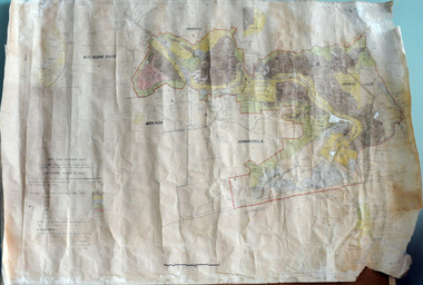
... (ref. 4 East Gippsland CMA Submission to Inquiry into Flood Mitigation Infrastructure in Victoria) ...(ref. 4 East Gippsland CMA Submission to Inquiry into Flood Mitigation Infrastructure in Victoria) This plan is significant as a historical document. ...Drainage infrastructure was developed and maintained in this region by the Snowy River Improvement Trust. The Trust was administered by a local committee and its activities funded by a local rate charged on the farmers and land owners in the Trust’s designated district. The level of the rate charged by the Trust was designed to be proportionate to the benefit derived from the works undertaken. Financial assistance was provided by the State Government from time to time for specific projects such as post flood repairs but not for new capital works. The Trust undertook new drainage and river management works including tree planting, rock beach construction and servicing of the drains and flood gates. The Trust also provided a personal flood warning service to the farmers in its district. The Trust ceased to operate in 1997 with the advent of the East Gippsland Catchment Management Authority. The infrastructure developed by the Trust continues to provide a service to the farmers in the region. (ref. 4 East Gippsland CMA Submission to Inquiry into Flood Mitigation Infrastructure in Victoria) This plan is significant as a historical document. The Snowy River Improvement Trust was vital to the Orbost district because of its ability to apply local knowledge and to engage the local farming community.A large plan of divisions of land for the purpose of levying the Snowy River Improvement District - Bete Bolong, Orbost, Waygara, Newmerella and Orbost East. The properties are coloured according to levy amount. The scale is 1" - 20 chains. snowy-river-improvement-trust -
 Orbost & District Historical Society
newspaper, PS Curlip, November 2008
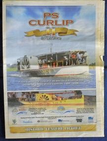
... It was operated along the Snowy River in Australia's Gippsland region between 1890 and 1919, before being washed out to sea, and broken on Marlo beach, by a flash flood. ...It was operated along the Snowy River in Australia's Gippsland region between 1890 and 1919, before being washed out to sea, and broken on Marlo beach, by a flash flood. ...This inset was published to commemorate the Curlip Festival on 28/30 November 2008 and the P.S. Curlip 11 launch. The Snowy River Mail is an East Gippsland Newspaper. The original PS Curlip was a paddle steamer built in a Tabbara sawmill in 1889 by Samuel Richardson and his sons. It was operated along the Snowy River in Australia's Gippsland region between 1890 and 1919, before being washed out to sea, and broken on Marlo beach, by a flash flood. The Orbost and district community started a project in 2002 to construct a live steam powered replica, albeit somewhat larger than the original to meet safety regulations and carry additional passengers for commercial reasons, the Paddle Steamer Curlip II with the assistance of grants from the Federal and Victorian State Governments.Construction was started in earnest by shipwright, Bill Jones, in August 2006, and with the assistance of roughly 200 volunteers (a core group of 10 performing the majority of the work), she was finally completed and launched on the Snowy River in late November 2008. The construction of P.S.Curlip 11 was a community project which began as a project to re-engage the timber-working community of Orbost. The construction and launch was a major community event. The local newspaper, The Snowy River Mail, documented its progress on a regular basis.An insert from the Snowy River Mail newspaper dated November 2008. On the front cover is a coloured photograph of the Paddle Steamer Curlip 11. It contains photographs, information on the history of P.S. Curlip and the construction of Curlip 11. There are details of the Curlip Festival and advertisements.newspaper p.s.curlip -
 Orbost & District Historical Society
newspapers, February, March 1971
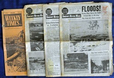
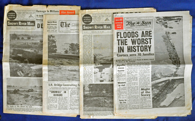
... Orbost & District Historical Society Ruskin Street Orbost gippsland The 1971 flood was the the worst flood on record. ...The 1971 flood was the the worst flood on record. At Jarrahmond it was at least 11 metres and up to one and a half kilometres wide on the flats causing enormous damage to the flood plain. Records say that "The brown floodwater stain in Bass Strait could be seen from passing airliners." Considerable damage was done to railway infrastructure, roads and farms. More information from the APRIL, 2008 newsletter by John Phillips. (see orbosthistory.com.au) These newspapers are contemporary records of a significant local event.Four newspapers relating to the floods in 1971. They contain news articles and photographs of the floods in Orbost in early 1971. 2556.1 is the Weekly Times dated 3.3.1971 and has an orange cover. 2556.2 is a Snowy River Mail dated 17.2.1971. 2556.3 is a Snowy River Mail dated 10.2.1971. 2556.4 is a Snowy River Mail dated 3.3.1971.floods-orbost-1971 snowy-river-mail weekly-times newspapers -
 Orbost & District Historical Society
newspapers, February 1971
... They contain information and photographs pertaining to the 1971 floods in Orbost. 2557.1 is a Sun News Pictorial dated 8.2.1971. 2557.2 is a Snowy River Mail dated 10.2.1971. 2557.3 is an east Gippsland News dated 12.2.1971. 2557.4 is a Snowy River mail dated 12.2.1971 and 2557.5 is a collection of various clippings....Orbost & District Historical Society Ruskin Street Orbost gippsland The 1971 floods at Orbost were the worst on record. ...The 1971 floods at Orbost were the worst on record. At Jarrahmond the river rose to a height of 11 metres and on the flats spread to one and a half kilometres wide. Considerable damage was done to railway infrastructure, roads and farms. More information from the APRIL, 2008 newsletter by John Phillips. (see orbosthistory.com.au)These newspapers are contemporary records of a significant local event.Four newspapers and a set of clippings from various papers. They contain information and photographs pertaining to the 1971 floods in Orbost. 2557.1 is a Sun News Pictorial dated 8.2.1971. 2557.2 is a Snowy River Mail dated 10.2.1971. 2557.3 is an east Gippsland News dated 12.2.1971. 2557.4 is a Snowy River mail dated 12.2.1971 and 2557.5 is a collection of various clippings.floods-orbost-1971 newspaper snowy-river-mail sun-news-pictorial -
 Orbost & District Historical Society
newspaper clippings, June 1978
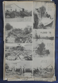
... Orbost & District Historical Society Ruskin Street Orbost gippsland Orbost has been subject to major floods throughout its history, such as those which left the town isolated in 1934, 1952, 1971 and 1978. ...Orbost has been subject to major floods throughout its history, such as those which left the town isolated in 1934, 1952, 1971 and 1978. It is recorded that the Snowy River broke its banks and flooded the flats 104 times between 1884 and 1978. Extensive flooding in Eastern Victoria during June 1978, caused widespread damage to roads, road closures and hazards to traffic, particularly over the Queen's Birthday holiday weekend. These newspaper articles are contemporary records of a significant event in Orbost history.A collection of black/white newspaper clippings relating to the 1978 flood in Orbost. Some are original articles. others are photo-copies. They appear to be from the Snowy River Mail newspaper.floods-orbost-1978 newspaper-articles -
 Orbost & District Historical Society
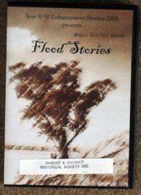
D.V.D, Flood Stories, 2006
... Orbost & District Historical Society Ruskin Street Orbost gippsland In October 2006, Orbost Secondary College 9/10 Enhancement Studies Class worked to preserve the memories of the Orbost community with three short films describing recollections of Orbost floods. ...In October 2006, Orbost Secondary College 9/10 Enhancement Studies Class worked to preserve the memories of the Orbost community with three short films describing recollections of Orbost floods. There are ten stories including memories of the 1952, 1971 and 1991 floods. They are narrated by various Orbost identities - Anne Bridges; Kay Lynn; Ken Edlington; Margaret Adams; Max Reynols; Shirley Reynolds and Ngaere Donald.Floods have been part of the history of Orbost since settlement. These stories record impressions of local people.A D.V.D. in a black plastic case. On the cover ia a brown sketch of a tree. Above in black print is the title, "Flood Stories" with " Year 9/10 Enhancement Studies 2006 presents" at the top.sticker and stamp - Orbost & District Historical Society -
 Orbost & District Historical Society
display cabinet and tools
... flood carried her and 2 barges down river and out to sea, where she washed ashore at Marlo and broke up. More than eighty years after the original Paddle Steamer Curlip was wrecked at sea, the Orbost community launched a replica which it hoped would draw tourists to the region. The P.S. Curlip II, is based on drawings of the original Curlip that made its home in the Snowy and Brodribb Rivers of East Gippsland ...This display was put together by the Curlip Committee and used as promotion in the shed during the construction of Curlip 11 A community project, this boat was constructed out of local hardwood timbers utilizing the traditional skills of wooden boat builders and is powered by a steam engine. Paddle Steamer Curlip II is a replica of an historic paddle steamer of the Snowy River, in Far East Gippsland, Victoria. The original Paddle Steamer Curlip was built by Sam Richardson and his sons Mark, Albert and Frank, at their sawmill at Tabbara, a pioneering settlement on the Brodribb River, a tributary of the Snowy River. The keel was laid on 14th October 1889 and PS Curlip was launched in 1890. The name “ Curlip” is derived from the indigenous name for the area where Tabbara is located and includes land to the east of the Snowy and Brodribb Rivers towards Cape Conran. PS Curlip was registered in 1893 and the Passenger Certificate issued on 30th January 1903 to Captain Alan Richardson by the Marine Board of Victoria entitled her to carry 25 passengers and only 10 passengers when engaged in towage service. Two children under 12 years of age to be reckoned as one passenger. PS Curlip towed five barges at a time, traveling upstream as far as Bete Bolong, 20 km upstream of the mouth to collect produce to be transferred to schooners near Marlo. She towed vessels in and out through the Snowy river entrance and was also used for social functions such as Sunday School picnics. She was the main means of transport for imports and exports on the Snowy River for almost 30 years. The Curlip era ended abruptly on Friday 28th February when a flash flood carried her and 2 barges down river and out to sea, where she washed ashore at Marlo and broke up.More than eighty years after the original Paddle Steamer Curlip was wrecked at sea, the Orbost community launched a replica which it hoped would draw tourists to the region. The P.S. Curlip II, is based on drawings of the original Curlip that made its home in the Snowy and Brodribb Rivers of East Gippsland in the 1890s and early 1900s, It took six years of planning and hundreds of hours of volunteer work from the local community.A display cabinet containing tools and sundry items related to the Paddle Steamer Curlip. (More information on individual items in Catalogue 1400-1600)p.s.curlip richardson-samuel boat-building-tools transport -
 Orbost & District Historical Society
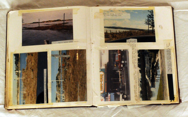
album, Our Natural Disasters Hailstorm 1991 Floods 1934-1998, between 1998 and 2003?
... Orbost & District Historical Society Ruskin Street Orbost gippsland This album was compiled for the use of visitors to the Slab Hut (Orbost Visitor Information Centre). This album is a useful research tool. slab-hut orbost-disasters album orbost-floods-fires-hailstorms A photo album with a maroon cover with gold embossing. ...This album was compiled for the use of visitors to the Slab Hut (Orbost Visitor Information Centre).This album is a useful research tool.A photo album with a maroon cover with gold embossing. On the cover is the title Our Natural Disasters. It contains 54 pages of photos of local natural disasters - flood, fire and hail. The photos are taped in.slab-hut orbost-disasters album orbost-floods-fires-hailstorms -
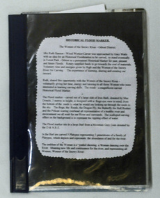 Orbost & District Historical Society
folder, Historical Flood Marker, 1999 - 2001
... Orbost & District Historical Society Ruskin Street Orbost gippsland This folder contains a record of the construction of the flood marker in Forest Park, Orbost. ...This folder contains a record of the construction of the flood marker in Forest Park, Orbost. It depicts the six highest floods since the first recording. The construction of the marker was commenced in August 1999 and took eighteen months to be completed by nine volunteers under the tutelage of Ruth Hansen.This item is a contemporary record of the construction of an iconic marker in Orbost.A loose leaf folder containing information, records and photographs about the Historic Flood Marker in Forest Park, Orbost. Most photographs and printed text are glued in. There are twelve loose photographs.The front cover and spine are dark blue, the back is a lighter blue and has a bar code and price sticker attached.flood-marker-orbost -
 Orbost & District Historical Society
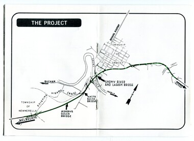
pamphlets, Princes Freeway - Orbost Section, 1976
... Gippsland. The original highway approached the Snowy River at a very poor alignment, and several serious accidents had occurred at the Orbost end. In times of heavy flood...Gippsland. The original highway approached the Snowy River at a very poor alignment, and several serious accidents had occurred at the Orbost end. In times of heavy flood ...Opened by the Hon. J A Rafferty, Minister for Transport, 25 November 1976, the bridge was the first of four bridges to be built as part of the freeway bypass of Orbost. Construction cost $2.4 million. This construction was an important development along the Princes Highway corridor through East Gippsland. The original highway approached the Snowy River at a very poor alignment, and several serious accidents had occurred at the Orbost end. In times of heavy flood, the highway on both sides of the river had been cut by floodwaters and during the 1971 floods, the highest ever recorded, the river was a mile wide at the crossing. Construction of the bridges commenced in January 1975, with an expectation to open the bridge across the Snowy River as soon as possible. Less than two years later, on 25 November 1976, the bridge across the Snowy River was opened to traffic, allowing the old bridge to be demolished. The remainder of the Orbost Bypass, both the floodplain crossings and the eastern section around the township itself, was declared ‘Princes Freeway’ and opened to traffic in December 1977. (ref http://mrv.ozroads.com.au) The Country Roads Board was the government authority for the construction and maintenance of main roads in Victoria between 1913 and 1983. It was succeeded by the Road Construction authority on 1 July 1983 and later merged with the Road Traffic Authority on July 1 1989 to form the Roads Corporation. James Cameron, an Orbost farming pioneer and Member of the Legislative Assembly, fathered the Country Roads Board. The opening of this Snowy River Bridge was an important development in the accessibility to the township of Orbost.Three coloured Country Roads pamphlets for the 'Princes Freeway - Orbost Section". On the front is a coloured photograph of the new construction over the Snowy River at Orbost. Inside is a program for a ceremony for the opening of the new Snowy River Bridge. There is also a black print map of the project. -
 Orbost & District Historical Society
walking stick, mid -late 20th century
... Orbost & District Historical Society Ruskin Street Orbost gippsland It was owned by Evelyn Paten ( nee Roberston) who was married to Thomas Paten who came to Orbost in 1893 and in 1907 began growing fancy bean seeds for H. James. He built the first private flood ...It was owned by Evelyn Paten ( nee Roberston) who was married to Thomas Paten who came to Orbost in 1893 and in 1907 began growing fancy bean seeds for H. James. He built the first private flood levee bank in the district. (ref Mary Gilbert) Evelyn Paten died in 1959, aged 85.A wooden walking stick with a rubber lip. The handle is joined with an inside screw. walking-stick paten-evelyn -
 Orbost & District Historical Society
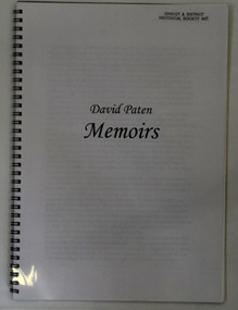
book, Greenland, Kate, David Paten Memoirs, 2005
... gippsland David Gordon Paten was born in 1917 in Orbost, Australia. He was the son of Evelyn Paten ( nee Roberston) and Thomas Paten who came to Orbost in 1893 and in 1907 began growing fancy bean seeds for H. James. He built the first private flood ...David Gordon Paten was born in 1917 in Orbost, Australia. He was the son of Evelyn Paten ( nee Roberston) and Thomas Paten who came to Orbost in 1893 and in 1907 began growing fancy bean seeds for H. James. He built the first private flood levee bank in the district. (ref Mary Gilbert) The book was edited by Kate Greenland on behalf of her grand-father, David Paten.This book of memoirs is a valuable reference for research into the early 20th century social history of Orbost.A 56 pp book with a plastic sheet cove. It is spiral bound in black plastic and is titled David Paten Memoirs. It was edited by Kate Greenland on behalf of her grand-father, David Paten.orbost-history paten-david -
 Orbost & District Historical Society
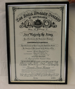
certificate/award, after 1934
... Orbost & District Historical Society Ruskin Street Orbost gippsland This certificate was presented to Donald David Thomson , sleeper hewer, aged 42 years for rescuing S.C. Curtis, aged 52, G. Wylie, aged 54, J. Dalgleish, aged 5 from flood ...This certificate was presented to Donald David Thomson , sleeper hewer, aged 42 years for rescuing S.C. Curtis, aged 52, G. Wylie, aged 54, J. Dalgleish, aged 5 from flood waters at White gulch on the Snowy River on January 8, 1934. (The certificate reads as White's Gulch but should be Watt's gulch.) Although damage estimated at 500,000 pounds was caused by the unprecedented floods along the Snowy River, no lives were lost because of the courageous actions of men like Donald Thomson.A framed copy of a printed and hand-written certificate from the Royal Humane Society of Australia awarded to Donald David Thomson for rescuing victims of the floodwaters in Orbost January 1934. It is dated 6.3.1934.Printed at top of certificate: THE ROYAL HUMANE SOCIETY / OF AUSTRALASIA. Has names of Society patrons and committee as well as names and ages of those rescued. award certificate royal-humane-society flood snowy-river 1934 thomson-david -
 Orbost & District Historical Society
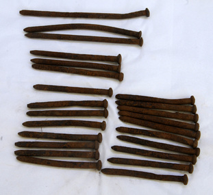
bridge spikes, 1922
... gippsland These spikes are from the old Snowy River bridge (the second) constructed in 1922 alongside the previous suspension bridge. Its building was a combined effort of the Victorian Railways and the Country Roads Board at a cost of 35,000 pounds. It was replaced in 1976 by the present bridge after several major floods ...These spikes are from the old Snowy River bridge (the second) constructed in 1922 alongside the previous suspension bridge. Its building was a combined effort of the Victorian Railways and the Country Roads Board at a cost of 35,000 pounds. It was replaced in 1976 by the present bridge after several major floods.These items are from a significant piece of infrastructure built in Orbost in the early 20th century. This bridge no longer exists.Twenty-four iron spikes of four different lengths. They are probably hand-made and have round shafts and heads. They are very rusty.snowy-river-bridge bridge-spikes bridge orbost -
 Orbost & District Historical Society
ginger jar, Pre 1893 floods in Orbost
... Gippsland in the 1840's. They lived in camps along the Marlo Road and houses were usually built on stilts. They left after the 1893 floods....Gippsland in the 1840's. They lived in camps along the Marlo Road and houses were usually built on stilts. They left after the 1893 floods. ...In the early days of Orbost many Chinese were engaged in land clearing or had arrived when gold was discovered in East Gippsland in the 1840's. They lived in camps along the Marlo Road and houses were usually built on stilts. They left after the 1893 floods.This object has aesthetic appeal. It is an object which belonged to the very early settlement days of Orbost.Huge, ornate Chinese ginger jar. Four raised hand- painted pink roses on front. Jar itself is matt black. Looks more like a vase than a ginger jar. Ceramic.Some Chinese writing to left hand side of roses.ceramics, ginger jar, container - domestic, vase -
 Gippsland Vehicle Collection
Book, Darge, Victoria's Leaders in the Motor Car World, 1911 (estimated); Based on make & models of vehicles, maps, and articles
... gippsland...cars...darge...broadbent...road map...advertisements...touring...james flood...Gippsland Vehicle Collection 1a Sale Road Maffra gippsland melbourne melba dame nellie melba gippsland cars darge broadbent road map advertisements touring james flood hudson berliet "The property of Bramwell" "thanks Fred" "Fred Armylope\19/7/68" Book of "Darge" photographs c.1911. ...Book of "Darge" photographs c.1911. Algenon Darge was a noted photographer in Melbourne around the commencement of the 20th century. 124 pages"The property of Bramwell" "thanks Fred" "Fred Armylope\19/7/68"melbourne, melba, dame nellie melba, gippsland, cars, darge, broadbent, road map, advertisements, touring, james flood, hudson, berliet -
 Orbost & District Historical Society
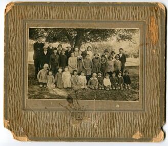
Photograph - Jarrahmond School & pupils c.1914
... gippsland The Jarrahmond State School No. 2745 near Orbost was one of the earliest in this district. It opened in 1886 at the same time as Orbost and shared a teacher (Campbell McKay who was shortly afterwards replaced by John Rowe who stayed in this position until 1908). The building was financed and built by local farmers on the Stapley property. After a large and damaging flood ...The Jarrahmond State School No. 2745 near Orbost was one of the earliest in this district. It opened in 1886 at the same time as Orbost and shared a teacher (Campbell McKay who was shortly afterwards replaced by John Rowe who stayed in this position until 1908). The building was financed and built by local farmers on the Stapley property. After a large and damaging flood in the nearby Snowy River in 1893 , the building was shifted to a new location. In 1926, a new building was constructed by the Vic Ed Dept. where it remained until the school was closed in 1948 and children from the Jarrahmond area were then bused to Orbost. Historical significance as one of the earliest photos of Jarrahmond School students.A b/w photo of a group of children and one adult in front of a tree. Children in the front are sitting on the ground, others are standing behind. Photo is mounted onto brown cardboard. On back of photo: Jarrahmond School c.1914. Sally Cole, Angus Cole.education, jarrahmond school, orbost -
 Orbost & District Historical Society
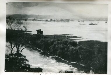
Photograph - Flood, Snowy River, Orbost 1978
... Orbost & District Historical Society Ruskin Street Orbost gippsland The Snowy River can flood over its floodplain at Orbost/Newmerella. ...The Snowy River can flood over its floodplain at Orbost/Newmerella. There have been wet periods when floods were frequent and covered the floodplain, sometimes causing great disruption to crops and farming, and also to transport. The 1970s was a wet decade with many floods, the largest one in 1971. This photograph was taken in 1978. Evidence of flood on the Snowy River in 1978. A b/w photograph of a flood scene with trees and the river in the front, a river bank, and a vast area of water in the background. This photograph has been pasted onto a rough cardboard backing. Written below the photograph: Orbost 1978floods, snowy river, orbost