Showing 325 items matching "gold mining site"
-
 Federation University Historical Collection
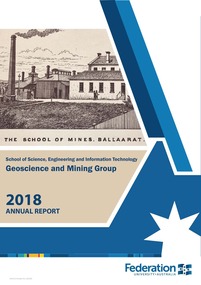
Booklet, Federation University Geoscience and Mining Group Annual Report, 2018, 2018
... central debosrah gold mining site visit...Barker Library (top floor) Mount Helen goldfields federation university australia school of science and information technology geoscience and mining group stephen carey selwyn medal stafford mcknight ausimm manoj khandelwal michael tuck greg you larissa loroznikova ander guinea haydn swan ausimm central victoria regional symposium\rex berthelsen timor-leste study tour nicole cox alfredo piros scholarship fred canavan award national australian mining games ausimm cody holman keith whitehouse aden cross brendan carlisle daiel matthews fosterville central debosrah gold mining site visit weekeroo ballarat east mine, castlemaine goldfields, ballarat rerilya limited, broken hill catalyst metals, bendigo agr geoscience, ballarat evolution mninig, cowal ramuelius resources, mt magnet gold mine, wa downer mining Blue and white soft covered report. ...Blue and white soft covered report. A pdf of this report is available with this record. federation university australia, school of science and information technology, geoscience and mining group, stephen carey, selwyn medal, stafford mcknight, ausimm, manoj khandelwal, michael tuck, greg you, larissa loroznikova, ander guinea, haydn swan, ausimm central victoria regional symposium\rex berthelsen, timor-leste study tour, nicole cox, alfredo piros scholarship, fred canavan award, national australian mining games ausimm, cody holman, keith whitehouse, aden cross, brendan carlisle, daiel matthews, fosterville, central debosrah gold mining site visit, weekeroo, ballarat east mine, castlemaine goldfields, ballarat, rerilya limited, broken hill, catalyst metals, bendigo, agr geoscience, ballarat, evolution mninig, cowal, ramuelius resources, mt magnet gold mine, wa, downer mining -
 Bendigo Historical Society Inc.
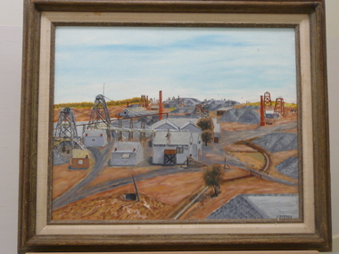
Painting - OIL PAINTING: GOLDEN MILE EAGLEHAWK
... ...gold mining site...History House 11 Mackenzie Street Bendigo goldfields PLACE Building gold mining site J.B. Perry Oil painting by J.B.Perry of Golden Mile Eaglehawk. ...Oil painting by J.B.Perry of Golden Mile Eaglehawk. Poppett Heads. Mining sheds. Duchess Tribute. G.M.Co. Painted in grey and brown oil colours. Markings on back: Golden Mile Eaglehawk. An original in oils from an early black & white photo by John. B. Perry. DR 277. Num 21.J.B. Perryplace, building, gold mining site -
 Greensborough Historical Society
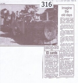
Newspaper clipping, Diamond Valley Leader, Imagine the old days, 10/09/1985
... News article relating the opening of a 'gold mining' site and wooden train at Westerfolds Park....Greensborough Historical Society 34A Glenauburn Road Lower Plenty Lower Plenty melbourne News article relating the opening of a 'gold mining' site and wooden train at Westerfolds Park. westerfolds park gold mine parks playgrounds george haslam yarra river Photocopy of article from Diamond Valley News 1985. ...News article relating the opening of a 'gold mining' site and wooden train at Westerfolds Park.Photocopy of article from Diamond Valley News 1985. Includes photograph of children on miniature train.westerfolds park, gold mine, parks, playgrounds, george haslam, yarra river -
 Stawell Historical Society Inc
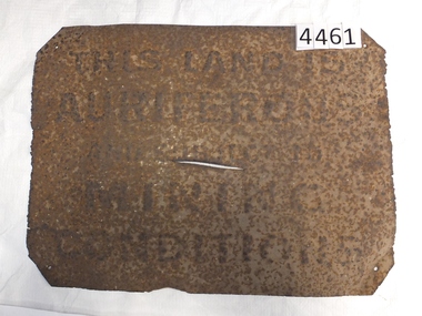
Memorabilia - Realia, 1850-1920's
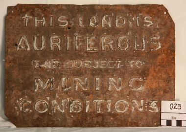
... Rusted Tin Sign – "THIS LAND IS AURIFEROUS AND SUBJECT TO MINING CONDITIONS" This sign was required to be displayed in the vicinity of gold mining sites. From 1850'c to between the two world wars. ...Stawell Historical Society Inc 46 Longfield St Stawell grampians Stawell Rusted Tin Sign – "THIS LAND IS AURIFEROUS AND SUBJECT TO MINING CONDITIONS" This sign was required to be displayed in the vicinity of gold mining sites. From 1850'c to between the two world wars. ...Rusted Tin Sign – "THIS LAND IS AURIFEROUS AND SUBJECT TO MINING CONDITIONS" This sign was required to be displayed in the vicinity of gold mining sites. From 1850'c to between the two world wars. Found near Rhymney Hill Great Westernc1966stawell -
 Bendigo Historical Society Inc.
Newspaper - Kangaroo Flat Gold Mine Collection: Bendigo Mining N.L, Department of Conservation and Environment, February 2006
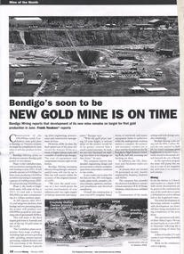
... mining...gold...construction site...Mining' February 2006, Mine of the Month, titled 'Bendigo's soon to be New Gold Mine is on time'. Development of the new mine in Bendigo remains on target for first gold production in June 2006. A labelled aerial photo of the construction site...Bendigo mining gold construction site Koeppern high pressure grinding rolls Atlas Copco MT 5010 50t haul truck Carshalton Eaglehawk SwanDecline decline Two page article, 'Australian Mining' February 2006, Mine of the Month, titled 'Bendigo's soon to be New Gold Mine is on time'. ...Two page article, 'Australian Mining' February 2006, Mine of the Month, titled 'Bendigo's soon to be New Gold Mine is on time'. Development of the new mine in Bendigo remains on target for first gold production in June 2006. A labelled aerial photo of the construction site in 2006, a schematic view of ribbon locations and two images of mining machinery used on site - Koeppern high pressure grinding rolls and an Atlas Copco MT 5010 50t haul truck - are included in the article. bendigo mining n.l., bendigo, mining, gold, construction site, koeppern high pressure grinding rolls, atlas copco mt 5010 50t haul truck, carshalton, eaglehawk, swandecline, decline -
 Myrtleford and District Historical Society
Gold Mining Sign
... This sign was required to be displayed in the vicinity of gold mining sites. Myrtleford district was known to have had 100 sites within a ten mile radius of the town; the sign was recovered by Charlie McFadyen, a local prospector and fossicker, of some 60 years...Myrtleford and District Historical Society 29 Elgin Street Myrtleford high-country This sign was required to be displayed in the vicinity of gold mining sites. Myrtleford district was known to have had 100 sites within a ten mile radius of the town; the sign was recovered by Charlie McFadyen, a local prospector and fossicker, of some 60 years The sign relates to local gold mining activity, a key source of wealth and employment from 1854 to the late 19th century. ...This sign was required to be displayed in the vicinity of gold mining sites. Myrtleford district was known to have had 100 sites within a ten mile radius of the town; the sign was recovered by Charlie McFadyen, a local prospector and fossicker, of some 60 yearsThe sign relates to local gold mining activity, a key source of wealth and employment from 1854 to the late 19th century. Such signs continued to be in use during the period between World War 1 and 2,including the period of the Great Depression.Tin rectangular mining sign embossed with a warningInscription: "THIS LAND IS AURIFEROUS AND SUBJECT TO MINING CONDITIONS"auriferous mining -
 Bendigo Historical Society Inc.
Photograph - AUSTIN COLLECTION: timbering a drive Williams United Gold Mine, Eaglehawk, 1987
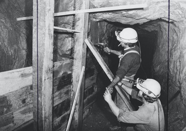
... The Williams United Shaft (New Chum Reef) is a significant historical gold mining site in Eaglehawk, a suburb of Bendigo, Victoria. ...History House 11 Mackenzie Street Bendigo goldfields The Williams United Shaft (New Chum Reef) is a significant historical gold mining site in Eaglehawk, a suburb of Bendigo, Victoria. ...The Williams United Shaft (New Chum Reef) is a significant historical gold mining site in Eaglehawk, a suburb of Bendigo, Victoria. Located at the end of Junction Street, this heritage-listed site contains remnants of mining infrastructure, including a poppet head, compressor beds, and a winder bed, amidst old open-cut workings and mullock heaps. The mine was part of the rich Bendigo goldfield and is recognized on the Victorian Heritage Inventory. In the 1980s, a company, Bendigo Mining NL, proposed a re- development of the mine with an opencut and underground workings, leading to environmental assessments and the collection of photographs of the decaying underground infrastructure.Black and white photograph: two miners timbering a drive at Williams United Gold Mine, Eaglehawk. Miner in background hammering a nail in, with hand extended to miner squatting on floor of drive, who is handing up a nail. Miner, holding the hammer, is smoking a cigarette.gold mining, underground, williams united gold mine, eaglehawk, western mining gmc, timbering -
 Bendigo Historical Society Inc.
Slide - DIGGERS & MINING. DIGGERS AND MINERS, c1860
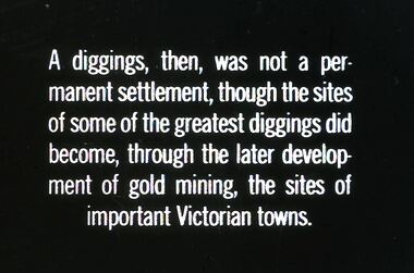
... Mining. Diggers and miners. A diggings, then, was not a permanent settlement, though the sites of some of the greatest diggings did become, through the later development of gold mining, the sites of important Victorian towns. ...Mining. Diggers and miners. A diggings, then, was not a permanent settlement, though the sites of some of the greatest diggings did become, through the later development of gold mining, the sites of important Victorian towns. ...Diggers & Mining. Diggers and miners. A diggings, then, was not a permanent settlement, though the sites of some of the greatest diggings did become, through the later development of gold mining, the sites of important Victorian towns. Markings: 33 994:LIF I. Used as a teaching aid.hanimounteducation, tertiary, goldfields -
 Bendigo Historical Society Inc.
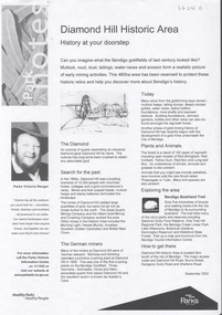
Document - DIAMOND HILL HISTORIC AREA PARKS VICTORIA
... On second page is a map of the area showing historic features: Deborah Consolidated Gold workings Red, White and Blue Extended gold workings Goldfields Extended gold workings Dead Dog Gully, alluvial gold workings Glasgow & Golconda Gold workings and tramway Surface gold mining site Hansel Mundy gold workings Bendigo Goldfields Pty gold workings Stafford gold workings Langdon gold workings Great Opossum Gully alluvial gold workings...Mining diamond hill Document, two pages, prepared by Parks Victoria in relation to the Diamond Hill Historic Area. Contains information regarding the history of the area; German Miners; Plants and animals. On second page is a map of the area showing historic features: Deborah Consolidated Gold workings Red, White and Blue Extended gold workings Goldfields Extended gold workings Dead Dog Gully, alluvial gold workings Glasgow & Golconda Gold workings and tramway Surface gold mining site Hansel Mundy gold workings Bendigo Goldfields Pty gold workings Stafford gold workings Langdon gold workings Great Opossum Gully alluvial gold workings Document DIAMOND HILL HISTORIC AREA PARKS VICTORIA ...Document, two pages, prepared by Parks Victoria in relation to the Diamond Hill Historic Area. Contains information regarding the history of the area; German Miners; Plants and animals. On second page is a map of the area showing historic features: Deborah Consolidated Gold workings Red, White and Blue Extended gold workings Goldfields Extended gold workings Dead Dog Gully, alluvial gold workings Glasgow & Golconda Gold workings and tramway Surface gold mining site Hansel Mundy gold workings Bendigo Goldfields Pty gold workings Stafford gold workings Langdon gold workings Great Opossum Gully alluvial gold workingsbendigo, mining, diamond hill -
 Bendigo Historical Society Inc.
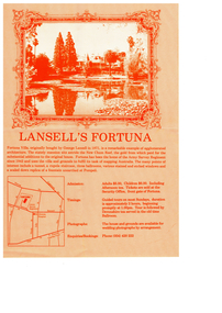
Pamphlet - Fortuna - Informatiopn Tourist Brochures, Early 2000s
... It was most recently used by the Defence Imagery and Geospatial Organisation (DIGO), which relocated in October 2008.The site is now surplus to Defence requirements, and investigations into its heritage and environmental values are underway to inform future disposal plans. Fortuna was historically significant in Bendigo's deep alluvial gold mining operations.The site was purchased from the Crown in 1857 by Theodore Ballerstedt and his father, Christopher, who arrived in Bendigo in 1853 from California....It was most recently used by the Defence Imagery and Geospatial Organisation (DIGO), which relocated in October 2008.The site is now surplus to Defence requirements, and investigations into its heritage and environmental values are underway to inform future disposal plans. Fortuna was historically significant in Bendigo's deep alluvial gold mining operations.The site was purchased from the Crown in 1857 by Theodore Ballerstedt and his father, Christopher, who arrived in Bendigo in 1853 from California. bendigo fortuna george lansell Ballerstadt Fortuna - Informatiopn Tourist Brochures This item contains the following documents: 11217.57a Four page colour brochure "Introducing the Defense Sire Fortuna - Centre pages contain a map of the site with prominant features. ...Defence Site Fortuna is a 7.5-hectare property located on the northern side of Chum Street at Golden Square, Bendigo, Victoria. The main building is Fortuna Villa, with additional structures including two accommodation buildings, a former mess building, storage buildings, and a parade ground. The property is owned by the Department of Defence. It was most recently used by the Defence Imagery and Geospatial Organisation (DIGO), which relocated in October 2008.The site is now surplus to Defence requirements, and investigations into its heritage and environmental values are underway to inform future disposal plans. Fortuna was historically significant in Bendigo's deep alluvial gold mining operations.The site was purchased from the Crown in 1857 by Theodore Ballerstedt and his father, Christopher, who arrived in Bendigo in 1853 from California.Fortuna - Informatiopn Tourist Brochures This item contains the following documents: 11217.57a Four page colour brochure "Introducing the Defense Sire Fortuna - Centre pages contain a map of the site with prominant features. Also parts of the back page describe " What is Happening at Fortuna"; significant values of the site and determination of disposal from the Defence Department. 11217.57b Four copies of A4 size coloured brochure, two-sided, tri-fold produced by the Villa Fortuna action Group 11217.57c A4 size coloured brochure, two-sided, tri-fold produced by the Bendigo Tourism Inc. Advertises two hour conductd and group tours 11217.57d Two copies of one page brochure advertiing guided toursnon-fictionbendigo, fortuna, george lansell, ballerstadt -
 Bendigo Historical Society Inc.
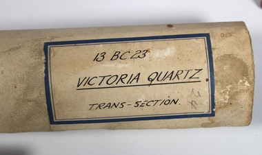
Plan - Victoria Quartz Gold Mine
... mining centre, The Victoria Hill Quartz Gold Mines are of historical, archaeological and scientific importance to the State of Victoria. The Victoria Hill Quartz Gold Mines are historically significant as the symbolic heart of Bendigo's famous goldfield. The mines are linked to nineteenth-century individuals (Christopher Ballerstedt and George Lansell) who played prominent roles in the evolution of Bendigo. Both men's fortunes and their influence on Bendigo, originated from mining operations carried out on the hill. The Victoria Hill Quartz Gold Mines are historically and scientifically important as characteristic examples of an important form of gold mining. Gold mining sites...mining centre, The Victoria Hill Quartz Gold Mines are of historical, archaeological and scientific importance to the State of Victoria. The Victoria Hill Quartz Gold Mines are historically significant as the symbolic heart of Bendigo's famous goldfield. The mines are linked to nineteenth-century individuals (Christopher Ballerstedt and George Lansell) who played prominent roles in the evolution of Bendigo. Both men's fortunes and their influence on Bendigo, originated from mining operations carried out on the hill. The Victoria Hill Quartz Gold Mines are historically and scientifically important as characteristic examples of an important form of gold mining. Gold mining sites ...The Victoria Quartz Gold Mine was situated on Victoria Hill, Ironbark, (1877 - 1913). At the turn of the century, this was the site of one of the premier mines on the Bendigo goldfield. In 1908, it boasted the world's deepest shaft - 4,478 feet (1,365 metres). The shaft reached a depth of 4,613 feet (1,406 metres) in 1910. In 1857 eight small claims in this area had been merged to form the Victoria Reef Quartz Mining Co. Another merger in 1877 led to the formation of the Victoria Quartz Co. For the next three decades, the mine produced consistent profits. In 1910, water burst into the claim, flooding the shaft and halting operations. The company baled water for six months then handed the mine over to the tributers who worked the upper levels for the share of the profits. The mine closed in 1913, having produced over 48,000 ounces of gold and paid dividends of £99,600. (Source, Goldfield Guide https://www.goldfieldsguide.com.au/explore-location/400/victoria-hill-mining-reserve/) Victorian Heritage Register information on mine: Statement of Significance Last updated on - July 14, 2005 The story of quartz mining on Victoria Hill lies at the heart of Bendigo's historical status as the world's richest and deepest reefing field. Gold was discovered on Victoria Hill in 1854, and by early 1855 claims had been taken up over its entire extent. Shafts were first worked by windlass, whip or whim, and primitive crushing batteries were in operation. By 1861, Victoria Hill had yielded at least 1,200,000oz in gold. One of the early claims on Victoria Hill was owned by Prussian immigrants, Christopher Ballerstedt and his son Theodore. In 1854, they bought a claim on the hill for £80, to which they subsequently added other claims, and from the quartz veins (called spurs), worked both by shafts and a large open cut, obtained gold worth nearly £200,000. Christopher Ballerstedt was dubbed 'Father of the Hill' and has been credited as the first to debunk the theory at that time prevalent on the Bendigo field, that the gold content of reefs would diminish at depth. As his shafts plunged below the 200-foot level, the quartz remained rich in gold. His success inspired others, and so led the way to Bendigo's later status as the world's deepest and richest goldfield. The Ballerstedt's built Bendigo's grandest mansion, Fortuna. Theodore continued to work Victoria Hill after his father's death, but in 1871, convinced that his claim was exhausted, he sold both mine and mansion to George Lansell for £60,000. Lansell's mine on Victoria Hill was called the 180, and operated under his ownership until his death in 1906. The mine supplied the initial wealth that made Lansell Bendigo's 'Quartz King'. George Lansell was such a force in Bendigo's mining history that his death was cited as one of the reasons for the decline of Bendigo as a quartz mining centre, The Victoria Hill Quartz Gold Mines are of historical, archaeological and scientific importance to the State of Victoria. The Victoria Hill Quartz Gold Mines are historically significant as the symbolic heart of Bendigo's famous goldfield. The mines are linked to nineteenth-century individuals (Christopher Ballerstedt and George Lansell) who played prominent roles in the evolution of Bendigo. Both men's fortunes and their influence on Bendigo, originated from mining operations carried out on the hill. The Victoria Hill Quartz Gold Mines are historically and scientifically important as characteristic examples of an important form of gold mining. Gold mining sites are of crucial importance for the pivotal role they have played since 1851 in the development of Victoria. As well as being a significant producer of Victoria's nineteenth century wealth, quartz mining, with its intensive reliance on machinery, played an important role in the development of Victorian manufacturing industry. The Victoria Hill Quartz Gold Mines are important as a manifestation of this aspect of gold mining. The Victoria Hill Quartz Gold Mines are scientifically important, as they contain relics span nearly sixty years of mining (1854 to 1913), documenting the richest and most significant years of Bendigo's world-famous quartz mining industry. Enhancing the significance of the place are relics from the Victoria Quartz Company operations, ncluding, at 4,870 feet, the world's deepest nineteenth-century gold mining shaft. As a postscript to the chronology of gold mining is the surviving crushing machinery (formerly part of the Bendigo Crushing Works) which was erected near the foundations of Lansell's 180 mine in 1932, to crush quartz for nearby mines. The place has a potential to yield artefacts and evidence which will be able to provide significant information about the technological history of gold mining. [Source: Victorian Heritage Register] Hermes Number 8506 https://vhd.heritagecouncil.vic.gov.au/index.php/places/8506/download-report Hand drawn plan of the bottom section of the Victoria Quartz Gold Mine. Mine shaft shown from 2706 feet to 5200 (potential) feet shown, with annotation regarding geological features and gold obtained from different level crushings. Blue border sticker on outside of plan: '13 BC 23 Victoria Quartz Trans-Section'. Plan is not dated. The Victoria Quartz plan is part of the Margaret Roberts Collection.victoria hill quartz gold mine, victoria hill -
 Kiewa Valley Historical Society
Book - Ledger Commercial, "Ledger No. 4", Circa 1895
... mining, agriculture, cattle and sheep it was also composed of a mixed society, encompassing all levels of society at that period. It identifies some the commercial activities(newsagency/general store) undertaken by specific families farming in the Kiewa Valley and relates their history in the pioneer period of the late 1800's. Some of those pioneers still have descendants living on the same home sites provided by the 1847 Land Act. grocery shop haberdashery general store On the suede spine in gold ...Historically this ledger not only details the legible hand writing of this era but also the day to day commercial activity in this region(first entry in 1895).The neatness and the diligence of those who were required to pen the information was a requirement by all who were in commercial trade. Emphasis on neatness was ingrained in students at a young age. This era was well before general typewriters and computers. Generally all students of commerce required an accuracy in writing and arithmetic. Neatness and order were a selection requirement. This ledger belonged to a general store, which was a forerunner to supermarkets and specialty stores. The shop provided everything from food, postage stamps, nails, tobacco, boots and Epsom salts. The general store provided nearly every product required to exist in a remote rural area of Australia in the 1800's.This item clearly identifies the Kiewa Valley as having a substantial financial hub to accommodate the various commercial enterprises within a rural environment Circa 1880's. Although Kiewa Valley had mining, agriculture, cattle and sheep it was also composed of a mixed society, encompassing all levels of society at that period. It identifies some the commercial activities(newsagency/general store) undertaken by specific families farming in the Kiewa Valley and relates their history in the pioneer period of the late 1800's. Some of those pioneers still have descendants living on the same home sites provided by the 1847 Land Act.This ledger has a very thick cover of strong compressed cardboard. Originally it had a cloth covering both front and back(Glued on) but due to wear and tear it is only attached to the back cover) and is a faded blue colour. The corners of the opening side of the cover are reinforced by suede cloth,in a triangular shape, and enclose both the front and inside portions of the the ledger. The spine is reinforced by a suede section to provide increased strength and protection. The inside cover (both front and back) has an orange bubbles with red and blue sinuous lines forming shapes in a haphazardous pattern. The grammage of the lined sheets (blue) is approximately 120g/m. Originally the first seven of twelve pages were indented and alphabetically marked with black letters (one letter per page) however this ledger had been modified to cover only the initials of customers and the pages of unused letters were glued to the previous page. The remaining pages are numbered in black print at the top outside edge of each page. There are 890 page numbers. Each page has thirty seven blue horizontal lines and one double red line ( top). Each page has thirteen vertical lines starting from the top horizontal double red lines and ending at the bottom of the page. These lines segregate the page into blocks for the date, the transaction and financial input. There are three double vertical red lines which designate the amount of money of each transaction (in pounds, shillings,and pence).On the suede spine in gold lettering and on a red (port coloured) background "LEDGER"grocery shop, haberdashery, general store -
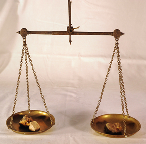 Orbost & District Historical Society
scales, Circa 1850's
... site. “The Nicholls family were very well known and highly respected at Tarnagulla in the 1800s. Albert's father, William Nicholls, was a leading figure in the gold mining community, and he both managed and owned quartz processing facilities for decades. ...site. “The Nicholls family were very well known and highly respected at Tarnagulla in the 1800s. Albert's father, William Nicholls, was a leading figure in the gold mining community, and he both managed and owned quartz processing facilities for decades. ...Scales were used in the Tarnagulla area of Central Victoria by Albert Charles Nicholls, who was a licensed assayer. This information comes from David Gordon of the Tarnagulla.com web-site. “The Nicholls family were very well known and highly respected at Tarnagulla in the 1800s. Albert's father, William Nicholls, was a leading figure in the gold mining community, and he both managed and owned quartz processing facilities for decades. He was probably the leading mining expert at Tarnagulla in a town full of mining experts, and it was said that no man at Tarnagulla had handled more gold over the years that him. (think in terms of tons of gold!) I would imagine the assaying equipment was probably passed in due course by William to Albert Charles. There are records of Albert Charles mining at Tarnagulla with his father as a young man, but AC apparently came down to the city when the gold began to fade. There are records of him living in Kew up until his death in 1932. He was employed as a draper for a long period.” This item is a significant item which is part of the history of gold mining in Victory.Gold assayer's scales, a very sensitive balance used in the assaying of gold, silver, etc.The scales are comprised of two circular brass pans suspended via brass chains to a metal balance.scales gold technology assayers tarnagulla -
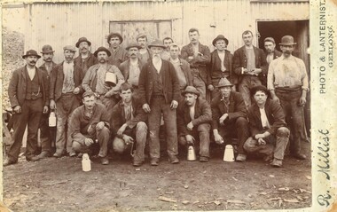 Federation University Historical Collection
Photograph, R. Millist, Hanlon Consols Mine Rokewood, 1901
... gold mining company near Rokewood. 1901 - Information Bendigo Prospecting Club, 21/08/2020. Information provided once again by Peter McCarthy. Christopher Hanlon had put down a line of bores south of the Rokewood main street, looking for a continuation of the Break O’Day lead which had been worked for two or three miles with highly payable results, though in a primitive manner. Ground was being paddocked 30 feet deep and made to pay. The bores suggested the sinking would be about 70 feet and a shaft site...gold mining company near Rokewood. 1901 - Information Bendigo Prospecting Club, 21/08/2020. Information provided once again by Peter McCarthy. Christopher Hanlon had put down a line of bores south of the Rokewood main street, looking for a continuation of the Break O’Day lead which had been worked for two or three miles with highly payable results, though in a primitive manner. Ground was being paddocked 30 feet deep and made to pay. The bores suggested the sinking would be about 70 feet and a shaft site ...The photo depicts one shift of mine hands at Hanlon Consols Mine Rokewod in 1901. ist on the left is George Edgar Yung. George was born in Ararat the son of Yohann Godlip and Christina (b Weller)Yung. They lived at Happy Valley near Linton. and Piggoreet. Yohann was a miner and died in the All Nations Mine collapse at Derwnt Jack's in 1877. Interesting to note in the following information that the Hanlon Consol mamager, William Maughan was also the manager of the Try Again Mine in Piggoreet. He was also on the six man school committee of Piggoreet Common School No. 726. (Is this why George Yung ended up working in Rokewood because of a previous connection at Piggoreet? George married Clara Emma Smith from Happy Valley and worked in a mine at Allendale. They later moved to Yendon) About the Hanlon gold mining company near Rokewood. 1901 - Information Bendigo Prospecting Club, 21/08/2020. Information provided once again by Peter McCarthy. Christopher Hanlon had put down a line of bores south of the Rokewood main street, looking for a continuation of the Break O’Day lead which had been worked for two or three miles with highly payable results, though in a primitive manner. Ground was being paddocked 30 feet deep and made to pay. The bores suggested the sinking would be about 70 feet and a shaft site was selected at the back of Stanbrook’s Hotel. The Hanlon Gold Mining Company was formed in March 1895 and the shaft was bottomed at 68 feet, getting just over an ounce of gold from the shaft bottom. By January 1896, the poppet heads were up, and steam plant was nearly ready. The mine produced 846 oz by September, which was not as good as expected, but they installed a second puddling machine. The mine was profitable for the next three years, with periods of prospecting and the need to install steam pumps in 1897. A second shaft was sunk in 1899, which bottomed at 86 feet on good wash and was sunk on to 109 feet. 1743 oz of gold had been produced in six months to September 1899, but the No1 shaft was let on tribute as the No2 workings were opened and machinery installed the following year. The No1 shaft tributors broke even in 1900 and in 1901 the shaft was shut down, with the No1 shaft machinery sold late in 1902. By September 1901, the mine had produced gold worth £66,124 and the No2 shaft main drive was in 346 feet, with gold being found mainly in crevices in the hard floor. Mining continued, but once the No2 shaft workings met up with the old No1 shaft workings at the end of 1902 there was not much wash remaining. The mine was let on tribute in June 1903 and a drive was put in to test deeper ground. The company was wound up in February 1904 and the plant sold. From what they discovered, the manager concluded that the mine sat at the edge of an ancient coastline and the gold was in a beach deposit. The total gold production from the mine was worth £73,294. J Lee Archer JP, shareholder, was the manager of the Bank of Victoria in Ballarat. Born in Tasmania, he came to Victoria with his parents and first came to Ballarat in 1855 as a junior clerk with the bank. He died in 1902 aged 64. Alexander J. Peacock was a legal manager and a share broker. In 1897 Peacock, born in Creswick, had been elected as one of the Victorian delegates to the Constitutional Convention which wrote the Australian Constitution. He later became a politician, state treasurer and three times state premier of Victoria and was knighted KCGM. He died in 1933 aged 72. William Maughan, director, was an English miner who came to Victoria in the 1850s and became a mine manager, managing the Try Again at Piggoreet, Ryan’s Freehold and the Madam Berry, among others. He died in Williamstown in 1915 aged 85. Sepia photographRhs front of photo: R. Millist Phto & Lanternist Geelong Verso (upside down): ONE SHIFT OF MINE HANDS HANLON CONSOLS MINE ROKEWOOD 1901 Grandfather Yung 1st on left rokewood, hanlon consols mine, shift of mine workers 1901, gold mines, george edgar godlip yung, william maughan -
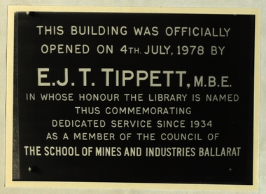 Federation University Historical Collection
Photograph, Ballarat School of Mines Library Plaques, c1970s and 1980s
... gold ores was first intriduced in California. A heavy iron stamp is raised on a cam and let fall so that its weight causes the quartz which is held in the mortar box. This three head battery was installed in the mining laboratory of The School of Mines, Ballarat in 1898 and crused many hundreds of tons of quartz. It was reected on this site...gold ores was first intriduced in California. A heavy iron stamp is raised on a cam and let fall so that its weight causes the quartz which is held in the mortar box. This three head battery was installed in the mining laboratory of The School of Mines, Ballarat in 1898 and crused many hundreds of tons of quartz. It was reected on this site ...The Ballarat School of Mines is a predecessor organisation of Federation University Australia.Black and white photographThis building was officially opened on 4th July, 1978 by E.J.T. Tippett, M.B.E. in whose honour the library was named thus commemorating dedicated service since 1934 as a member of the Council of the School of Mines and Industries Ballarat Stamp Battery The stamp battery for treating gold ores was first intriduced in California. A heavy iron stamp is raised on a cam and let fall so that its weight causes the quartz which is held in the mortar box. This three head battery was installed in the mining laboratory of The School of Mines, Ballarat in 1898 and crused many hundreds of tons of quartz. It was reected on this site to commeorate the centenary of the School of Mines in 1870. School of Mines & Industries Ballarat Established - 1870 Stage one of The Vocational Skills Centre was officially opened by The Hon. Robert Fordham M.P. Minister of Education on 29th April 1983 P.R. Shiells K.J. Flecknoe Principal President The School of Mines and Industries Ballarat Established - 1870 This plaque commemorates the opening of the Hairdressing School on 9 March 1983 by Peter Cutter, B. Comms, M. Ed. General Manager - Programs, TAFE Board School of Mines and Industries Ballarat Ltd Land Laboratory officially opened by Dr D.F. Smith Director of Agriculture on 12th November 1980. School of Mines & Industries Ballarat Amenities Building was officially opened by His excellency The Hon. Sir Henry Winneke K.C.M.G., K.C.V.O., O.B.E.. K. St. J., O.C., Governor of Victoria on 7th October 1981 G.H. Beanland K.J. Beanland Principal President This room is known as the Yates Geological Centre in recognition of a professional lifetime of service from 1920=1962 as' head of Geology in The SChool of Mines and Industries Ballarat by Harold Yates M.Sc Plaque presented by former students This stone was laid by The Hon. Alexr J. Peacock Minister of Public Instruction April 14th 1899 Abdrew Anderson, Presidentbuildings, ballarat school of mines, smb campus, premier of victoria, plaque, e.j.t. tippett library, tippett learning research centre, smb library, ballarat school of mines library, e.j. tippett, smb foundation stone, smb stamp battery plaque, geology centre - yates, yates geological centre, smb amenities building opening, smb land laborarory opening, smb hairdressing school opening, smb vocational centre (stage 1) opening, smb e.j. tippett library opening, former ballarat gaol national trust plaque, former ballarat supreme court national trust plaque, smb buildings - administration national trust plaque, foundation of technical education in australia, ballarat school of mines foundation stone, yates geology centre, amenities building, land laboratory, former ballarat gaol, former ballarat supreme court, courthouse theatre, stamp battery, stamper battery, centenary, anniversary, mortar box, peter shiells, ken flecknoe, vocatonal skills centre, haidressing school, peter cutter, museum building, former wesley church, henry winneke, graham beanland, harold yates, alexander peacock, andrew anderson, a building, administration building -
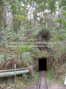 Eltham District Historical Society Inc
Photograph - Digital Photograph, Marguerite Marshall, One Tree Hill Mine, Smiths Gully, 8 June 2006
... gold, won from 57 pounds (26kg) of stone.4 Then during World War Two, Stan’s uncle, Bill Wallace, and Alex Bone, closed the mine. In 1973, Stan, with his Uncle Bill, reopened the Black Cameron Mine and worked there until 1988. Stan resumed mining One Tree Hill in 1998. As late as the 1920s gold was picked up by chance! When crossing a gully on his way to vote at the St Andrews Primary School, Bill Joyce picked up some quartz containing gold. This site...gold, won from 57 pounds (26kg) of stone.4 Then during World War Two, Stan’s uncle, Bill Wallace, and Alex Bone, closed the mine. In 1973, Stan, with his Uncle Bill, reopened the Black Cameron Mine and worked there until 1988. Stan resumed mining One Tree Hill in 1998. As late as the 1920s gold was picked up by chance! When crossing a gully on his way to vote at the St Andrews Primary School, Bill Joyce picked up some quartz containing gold. This site ...Gold was discovered on One Tree Hill in 1854. The site has been worked intermittently until fairly recent times. Published: Nillumbik Now and Then / Marguerite Marshall 2008; photographs Alan King with Marguerite Marshall.; p53 Though still a working mine, One Tree Hill Mine at Smiths Gully, now stands in a tranquil reserve surrounded by bush and native animals - in contrast to its heyday. In the mid 19th century, when the mine was part of the Caledonia Goldfields, hundreds of men in search of their fortune worked the alluvial gold in the Yarra River, its tributaries and the reefs that made up the goldfields. Miner Stan Bone, assisted by Wilfred Haywood, is the last of the independent gold miners in the area and still uses the quartz crushing battery as miners did when gold was first discovered in the area in 1851.1 Stan, who is the last of six generations of miners in his family, was aged 17 when he began mining on his father Alex’ mine, The Golden Crown in Yarrambat. These days, after blasting the gold-bearing rock in Mystery Reef, one of the four reefs at One Tree Hill, Stan transports it around five kilometres by tip truck to the Black Cameron Mine for crushing. There he uses water from the waterlogged mine, (which still contains gold), as the Happy Valley Creek at One Tree Hill is usually dry.2 The One Tree Hill Mine has been worked for close to a century since it opened around the late 1850s.3 The Swedish Reef was its most productive reef and one of the largest in the area. Around 1859, extractions included 204 ounces (5.8kg) of gold, won from 57 pounds (26kg) of stone.4 Then during World War Two, Stan’s uncle, Bill Wallace, and Alex Bone, closed the mine. In 1973, Stan, with his Uncle Bill, reopened the Black Cameron Mine and worked there until 1988. Stan resumed mining One Tree Hill in 1998. As late as the 1920s gold was picked up by chance! When crossing a gully on his way to vote at the St Andrews Primary School, Bill Joyce picked up some quartz containing gold. This site was to become the Black Cameron Mine. The Caledonia Diggings, named after Scotland’s ancient name by local Scots, began around Market Square (now Smiths Gully) and included Queenstown (St Andrews), Kingstown (Panton Hill) and Diamond Creek. There were also poorer bearing fields in Kangaroo Ground and Swipers Gully (now Research). * None of these compared in riches to the Ballarat and Bendigo fields5, but the Caledonia Diggings continued intermittently for close to 100 years. Gold was discovered in Victoria following a bid to stem the disappearance of much needed workmen to the New South Wales diggings. Several businessmen offered a reward of £200, for the discovery of gold within 200 miles (322 km) of Melbourne. Late in June 1851, gold was first discovered at Andersons Creek, Warrandyte. Then in 1854, George Boston and two other men discovered gold at Smiths Gully. Gold transformed the quiet districts, with a constant flow of families and vehicles on the dirt tracks en route to the Caledonia Diggings. Three thousand people worked the gullies in Market Square, including about 1000 Chinese miners. The square established its own police, mining warden, gold battery, school, shops and cemetery and grog flowed. Market Square flourished until the middle 1860s. Bullocks transported quartz from the Caledonia Goldfields to the crushing machinery at the Queenstown/St Andrews Battery, near Smiths Gully Cemetery. It was destroyed by bushfire in 1962. By the late 1850s, most early alluvial fields were in decline, but minor rushes continued until around 1900 and some until the early 1940s. Some miners did well, although most earned little from their hard labour in the harsh and primitive conditions.6 But according to historian, Mick Woiwod, the gold fields helped to democratise society, as individuals from all walks of life were forced to share experiences, and the ability to succeed, depended less on inherited wealth or social rank.This collection of almost 130 photos about places and people within the Shire of Nillumbik, an urban and rural municipality in Melbourne's north, contributes to an understanding of the history of the Shire. Published in 2008 immediately prior to the Black Saturday bushfires of February 7, 2009, it documents sites that were impacted, and in some cases destroyed by the fires. It includes photographs taken especially for the publication, creating a unique time capsule representing the Shire in the early 21st century. It remains the most recent comprehenesive publication devoted to the Shire's history connecting local residents to the past. nillumbik now and then (marshall-king) collection, gold mining, one tree hill mine, smiths gully -
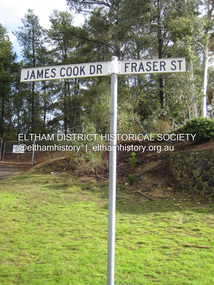 Eltham District Historical Society Inc
Photograph - Digital Photograph, Alan King, Site of the Diamond Creek Gold Mine, 28 December 2007
... sites that were impacted, and in some cases destroyed by the fires. It includes photographs taken especially for the publication, creating a unique time capsule representing the Shire in the early 21st century. It remains the most recent comprehenesive publication devoted to the Shire's history connecting local residents to the past. Nillumbik Now and Then (Marshall-King) Collection Diamond Creek Diamond Creek Mine Fraser Street Gold mining ...The largest gold mine in the area originated from a find in 1862. The mine was closed January 20, 1915 when a fire destroyed nearly all the above ground plant. Published: Nillumbik Now and Then / Marguerite Marshall 2008; photographs Alan King with Marguerite Marshall.; p75 Beneath Mine Hill, as locals call it, runs a network of tunnels once of central importance to the fledgling township of Diamond Creek. These are relics of gold mines, which transformed early Diamond Creek.1 The tiny settlement of about 20 families soared to more than 200 because of gold. For around 50 years, from 1862, gold mining was Diamond Creek’s major source of employment. On September 7, 1854 The Argus newspaper reported a find of a four pound (1.8kg) gold nugget in Nillumbik (an early name for Diamond Creek). Exactly where, is not known.2 The largest mine in the district, the Diamond Creek Gold Mine, apparently originated from a find in 1862. It is said Joe and Dave Wilson were visiting former tailor then cook, Charles Orme, at the southern end of Fraser Street. Sitting on a stump outside the front gate on land belonging to Dr A. E. Phipps the Wilsons found a vein of gold-bearing quartz, which led to the discovery of four quartz reefs varying in width to eight inches (20cm), running north and south. A reef found at the foot of the hill opposite Challenger Street became the Union Mine. This reef was traced south to Allendale Road where a small mine began operations.3 Other smaller mines later operated as well. Dr Phipps immediately began to mine and also built the Diamond Reef Hotel as a boarding house for miners. But Charles Orme, who owned the land alongside, leased his mine to Dr Phipps probably because of insufficient funds and business skills. By mid 1865 the mine had produced 2530 ounces of gold – a 100% profit on the original outlay. Of course there were problems. When the local dam dried up a Blake pump was installed to draw water from the creek. The Union Mine operated under the Diamond Creek Gold Mine management except when disputes sometimes resulted in separate management. However disagreements had to be resolved as the Union Mine depended on Diamond Creek Gold Mine pumps to remove underground water from common reefs. In 1912 the main shaft of about 380 yards (350m) employed 200 men recovering an average of 5000 ounces (141.7kg) of gold a year. But not everyone did well out of gold. Records of failed mining companies in the Victorian Public Record Office, reveal that owner Dr Phipps leased his Right to others. Companies came and went over the next 40 years, most sponsored by Melbourne businessmen who sold shares to gullible locals and then became insolvent. Although there were some good profits, financial returns were haphazard until 1905. Some local residents, who were share holders in short- term companies, became well-known names in modern Diamond Creek such as Scott, Haley, Butler, Alder, Ryan, Wadeson, Reeves, Alston, Paul and Edwards. Gold mining was brought to a disastrous end on January 20, 1915 at 3 pm, when fire destroyed nearly all the above-ground plant. Fortunately no lives were lost. But reopening the mine was almost impossible because of the increasing depth of water in the main shaft. The closed mine destroyed the livelihood of 200 families and the debris took many years to clear.4 In 1946 the Diamond Creek Gold Mine was reopened by the Golden Hind Mining Company, but money ran out before the 600 feet (182.8m) or so of water could be removed. Gold remains in the mine but enormous capital would be needed to buy the land, equipment and to remove the water. Today 12 known sealed shafts along the ridge of the hills on private property extend west for around one kilometre from the corner of Fraser and Haley Streets, crossing Norma and Fyffe to Dering Streets. As recently as 1987, heavy rains revealed a former Union Mine shaft in the Georgiadis family Fyffe Street back yard.5 Allendale Mine, south of Allendale Road, is still open and one of the Union Mine’s main drives (horizontal excavation) remains unsealed, on the Creek Reserve.This collection of almost 130 photos about places and people within the Shire of Nillumbik, an urban and rural municipality in Melbourne's north, contributes to an understanding of the history of the Shire. Published in 2008 immediately prior to the Black Saturday bushfires of February 7, 2009, it documents sites that were impacted, and in some cases destroyed by the fires. It includes photographs taken especially for the publication, creating a unique time capsule representing the Shire in the early 21st century. It remains the most recent comprehenesive publication devoted to the Shire's history connecting local residents to the past. nillumbik now and then (marshall-king) collection, diamond creek, diamond creek mine, fraser street, gold mining, james cook drive, mine hill -
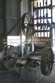 Eltham District Historical Society Inc
Photograph - Digital Photograph, Alan King, Ore crusher, Golden King mine, Yarrambat, 22 January 2008
... sites that were impacted, and in some cases destroyed by the fires. It includes photographs taken especially for the publication, creating a unique time capsule representing the Shire in the early 21st century. It remains the most recent comprehenesive publication devoted to the Shire's history connecting local residents to the past. Nillumbik Now and Then (Marshall-King) Collection Battery Clayton family Gold mining ...Prior to 1929 Yarrambat was known as Tanck's Corner or Reynold's Corner after Frederick Tanck who owned land north of Ironbark Road at the corner of Yan Yean Road, and Thomas Ryenolds who owned the property opposite. Tanck's Corner was at the centre of gold bearing country. Gold was mined here until 1984 when the last operating mine, the Golden King mine in North Oatlands Road closed. It was owned by the Clayton family and in the 1960s was the only private family gold mine in Victoria. Larger mines had their own batteries and stampers to process the ore. Covered under Heritage Overlay, Nillumbik Planning Scheme. Published: Nillumbik Now and Then / Marguerite Marshall 2008; photographs Alan King with Marguerite Marshall.; p23This collection of almost 130 photos about places and people within the Shire of Nillumbik, an urban and rural municipality in Melbourne's north, contributes to an understanding of the history of the Shire. Published in 2008 immediately prior to the Black Saturday bushfires of February 7, 2009, it documents sites that were impacted, and in some cases destroyed by the fires. It includes photographs taken especially for the publication, creating a unique time capsule representing the Shire in the early 21st century. It remains the most recent comprehenesive publication devoted to the Shire's history connecting local residents to the past. nillumbik now and then (marshall-king) collection, battery, clayton family, gold mining, golden king mine, ore crusher, tancks corner. reynolds corner, yarrambat -
 Bendigo Historical Society Inc.
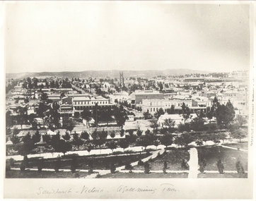
Photograph - SANDHURST - VICTORIA, A GOLD MINING TOWN, Earliest c 1885
... Gold-Mining Town'. View from Rosalind Park. Notable BLDOR Shamrock Hotel, St Pauls Church, railway station. Inscription: on RH 'Extract from cement -???'. Photograph shows early Sandhurst with Chimney of Goldmine of R.H.S(R.S.L now occupies this site)....Gold-Mining Town'. View from Rosalind Park. Notable BLDOR Shamrock Hotel, St Pauls Church, railway station. Inscription: on RH 'Extract from cement -???'. Photograph shows early Sandhurst with Chimney of Goldmine of R.H.S(R.S.L now occupies this site). ...B+W Photograph. Copy of 'Sandhurst - Victoria a Gold-Mining Town'. View from Rosalind Park. Notable BLDOR Shamrock Hotel, St Pauls Church, railway station. Inscription: on RH 'Extract from cement -???'. Photograph shows early Sandhurst with Chimney of Goldmine of R.H.S(R.S.L now occupies this site).place, landscape view, sandhurst from rosalind park -
 Bendigo Historical Society Inc.
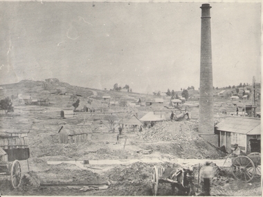
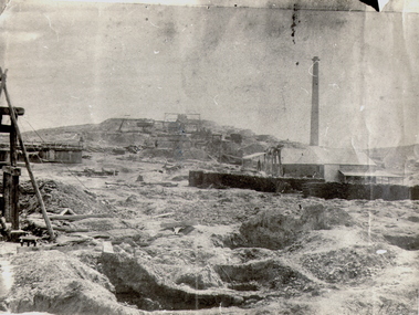
Photograph - GOLD MINES BENDIGO 1861, 1861
... Mining site sth victoria hill ? see also 131.01 Copy of photograph of mine site with dwellings to right top, mine buildings, 'whim?' drays, horse and work men. Large brick chimney on right. B+W photo. On back 'Gold ...Copy of photograph of mine site with dwellings to right top, mine buildings, 'whim?' drays, horse and work men. Large brick chimney on right. B+W photo. On back 'Gold Mines Bendigo 1861','Probably, looking NW up New Chum Hill, which was then known as Sth Victoria Hill'.place, mining site, sth victoria hill ?, see also 131.01 -
 Bendigo Historical Society Inc.
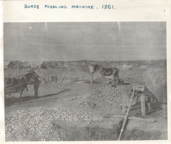
Photograph - HORSE PUDDLING MACHINE VICTORIA HILL?, c.1861
... Mining site victoria hill ? Black and white panorama with mine workings (puddling machine and two horses and two workers) with scattered (residential?) buildings in open rough background. Inscriptions: on front - 'horse puddling machine 1861' hand printed across top. On back - 'Gold ...Black and white panorama with mine workings (puddling machine and two horses and two workers) with scattered (residential?) buildings in open rough background. Inscriptions: on front - 'horse puddling machine 1861' hand printed across top. On back - 'Gold Mines Bendigo 1861, this could be Victoria Hill'.place, mining site, victoria hill ? -
 Bendigo Historical Society Inc.
Photograph - NEW CHUM HILL?
... Mining site new chum Batchelder Black and white photograph of mine site. Mullock heap in background with various mine buildings. Chimney stack and corrugated iron buildings on right. Mine shaft holes in foreground. Whims centre back. Hand written on back 'Gold ...Black and white photograph of mine site. Mullock heap in background with various mine buildings. Chimney stack and corrugated iron buildings on right. Mine shaft holes in foreground. Whims centre back. Hand written on back 'Gold Mines Bendigo. Probably New Chum Hill. Looking North. Phoenix, later Old Chum Mine at summit. JB Lazarus' claims in foreground. RT. 'Johnsons No. 2' on back - Royal Historical Society of Victoria, Bendigo Branch. Circular stamp. History: Prev. ACC. No. MNG 2Batchelderplace, mining site, new chum -
 Bendigo Historical Society Inc.
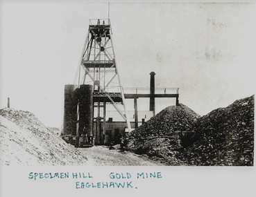
Photograph - SPECIMeN HILL GOLD MINE
... gold mine Eaglehawk mines and mining mine mines mining poppet head Black and white photograph. Poppet head with tubular steel legs and two stages lattice stays to braces. Winder house overhead tramway and mullock dump. Chimney at rear. Two tubular steel storage bins. Inscriptions:on site ...Black and white photograph. Poppet head with tubular steel legs and two stages lattice stays to braces. Winder house overhead tramway and mullock dump. Chimney at rear. Two tubular steel storage bins. Inscriptions:on site - 'Specimen Hill U G M Co', On front - bottom of photograph 'Specimen Hill Gold Mine, Eaglehawk', on rear - '22', 'Speciment Hill Mine Eaglehawk'.mine, gold, specimen hill (eaglehawk )., bendigo, specimen hill, gold mine, eaglehawk, mines and mining, mine, mines, mining, poppet head -
 Bendigo Historical Society Inc.
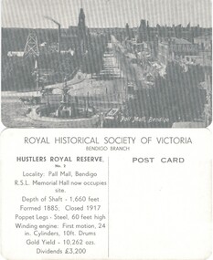
Photograph - HUSTLERS ROYAL RESERVE NO. 2 (POSTCARDS)
... History House 11 Mackenzie Street Bendigo goldfields PLACE Mining site hustlers royal reserve no 2 Hustlers Royal Reserve No. 2 (Postcards of the Royal Historical Society of Victoria - Bendigo Branch. 10 identical postcards showing mine and Pall Mall, Bendigo. On reverse: LH side with details of locality, shaft, poppet and engine details, gold ...Hustlers Royal Reserve No. 2 (Postcards of the Royal Historical Society of Victoria - Bendigo Branch. 10 identical postcards showing mine and Pall Mall, Bendigo. On reverse: LH side with details of locality, shaft, poppet and engine details, gold yield and dividends. RH Side - blank for addresseeplace, mining site, hustlers royal reserve no 2 -
 Bendigo Historical Society Inc.
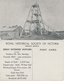
Photograph - GREAT EXTENDED HUSTLERS (POSTCARD)
... History House 11 Mackenzie Street Bendigo goldfields PLACE Mining site great extended hustler quartz mine Great Extended Hustlers (Postcard series of the Royal Historical Society of Victoria (Bendigo Branch). 8 identical cards. Summary history of mine on reverse, LH side: Location, depth, poppet and engine detail, gold yield, dividends. ...Great Extended Hustlers (Postcard series of the Royal Historical Society of Victoria (Bendigo Branch). 8 identical cards. Summary history of mine on reverse, LH side: Location, depth, poppet and engine detail, gold yield, dividends. Blank (unused) on RH side for addressee.place, mining site, great extended hustler quartz mine -
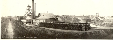
 Bendigo Historical Society Inc.
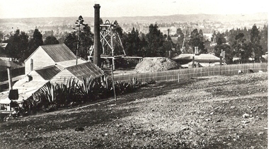
Photograph - MINE SITE
... History House 11 Mackenzie Street Bendigo goldfields BHS Collection BENDIGO Mining hustler's royal reserve mine Bendigo mines and mining mines mining gold mining gold gold mines place Bendigo mines Black and white photograph of the Hustler's Mine as a part of the Bendigo mining landscape with the valley in the background. On the left hand side is the poppet head, chimney and mining sheds and in the foreground is the bare stony earth. Photograph MINE SITE ...BHS CollectionBlack and white photograph of the Hustler's Mine as a part of the Bendigo mining landscape with the valley in the background. On the left hand side is the poppet head, chimney and mining sheds and in the foreground is the bare stony earth.bendigo, mining, hustler's royal reserve mine, bendigo, mines and mining, mines, mining, gold mining, gold, gold mines, place, bendigo mines -
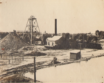
 Bendigo Historical Society Inc.
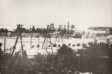
Photograph - CENTRAL BLUE MINE, 1912
... History House 11 Mackenzie Street Bendigo goldfields MINE Gold central blue Bendigo mines and mining surface equipment place mining surface equipment flying fox poppet head Black and white photo: mine site with poppet head, mine buildings at rear right . ...Black and white photo: mine site with poppet head, mine buildings at rear right . Trestles and cables carrying rectangular bins across open land. Large mound of material behind main building. Trees and weatherboard building in foreground. On back written in ball point pen and underlined ' flying Fox' Central Blue Mine to Crushing Battery 1912 'mine, gold, central blue, bendigo, mines and mining, surface equipment, place, mining, surface equipment, flying fox, poppet head -
 Bendigo Historical Society Inc.
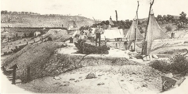
Photograph - MINERS AT VICTORIA REEF, c.1857
... Gold victoria hill Book 'Bendigo the German Chapter' by Frank Cusack. P52. mines and mining mine place workers miners mining equipment equipment Frank Cusack history Alex Fox Black and white photograph of sketch of workmen at mine site. ...Black and white photograph of sketch of workmen at mine site. Air ventilators on top of mine shafts to R. Wheelbarrow at R foreground. Wind socks or sails were used to ventilate the holes. History: 'Victoria Reef 1857, Frank Cusack after a photograph by Alex Fox.Alex Foxmine, gold, victoria hill, book 'bendigo, the german chapter' by frank cusack. p52., mines and mining, mine, place, workers, miners, mining equipment, equipment, frank cusack, history -
 Bendigo Historical Society Inc.
Photograph - NEW CHUM RAILWAY GOLD MINE
... History House 11 Mackenzie Street Bendigo goldfields MINE Gold new chum hill 180 mine Bendigo mines and mining railway line gold mine mines place gold mines Black and white photograph. Mine site ...Black and white photograph. Mine site with poppet head and mine buildings. Stacks of wood in foreground. Two chimneys. Poppet heads and chimneys in background. Inscriptions: in image - printed at BL '..w Chum Railway Gold Mine * 4226 feet, deepest in the world'. 'New Chum Railway 4,318 feet deep. One of the deepest in the world', 'A Richardson, 29 Harrison St, Bendigo'. All written on back in ballpoint pen.mine, gold, new chum hill, 180 mine, bendigo, mines and mining, railway line, gold mine, mines, place, gold mines -
 Bendigo Historical Society Inc.
Photograph - NORTH DEBORAH GOLD MINE, c.1920
... Mining site deborah Black and white photograph. Pool in foreground, mullock heap, poppet head, mine buildings, chimney, trees and town buildings in background. Mounted on masonite. Inscriptions: 'North Deborah' on back. Photograph NORTH DEBORAH GOLD ...Black and white photograph. Pool in foreground, mullock heap, poppet head, mine buildings, chimney, trees and town buildings in background. Mounted on masonite. Inscriptions: 'North Deborah' on back.place, mining site, deborah