Showing 22 items matching "griffiths land"
-
 Flagstaff Hill Maritime Museum and Village
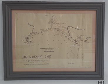
Document - Location Chart, The Mahogany Ship, 2007
... ...Griffiths Land...Stanley Admiralty Chart 1872 Tower Hill Merri River Moyne River Middle Island Helen Rock Armstrong Bay Griffiths Land Lower left: "THE MAHOGANY SHIP" "LOCALITY PLAN, ENLARGED FROM LIEUT. ...This chart shows a possible site for the fabled wreck called the 'Mahogany Ship'. Flagstaff Hill’s collection includes other objects that some say could be relics from this Ancient Wreck, (also called the Gold Ship, or the Ancient Vessel). The chart shows the coordinates for the Summits of Griffith Island and of Middle Island. It also has the depths of the sea at various intervals and shows the shore and sand dunes, lighthouses and other reference points. The mystery of the Mahogany Ship began in 1836 when two shipwrecked sealers discovered the remains of an “ancient vessel” in the sand dunes about four miles west of Warrnambool. Since the last recorded sightings in the 1880’s the true origin of the Mahogany Ship has remained one of Australia’s most famous historical mysteries or fables. One of the more recent theories is that the vessel was one of the Portuguese ships exploring the Australian coast in 1522. For over one hundred years searchers have attempted to locate and identify the wreck. The search continues for the tangible evidence which will once and for all establish the Mahogany Ship’s place in Australia’s History.The chart represents the worldwide interest in locating the wreck of the Mahogany Ship. Locating the actual wreck or proving the existence of a Portuguese ship's wreck could change the history of the discovery of Australia. A Mahogany Ship committee was formed to gather and research information about the discovery of the wrecked ship. A large amount of money was offered as a prize for finding the wreck or parts of it. People have written books, painted images, made videos and told tales of the ship but it continues to remain a mystery or even a fable. The chart is significant for its possible link to one of Victoria’s and Australia’s maritime mysteries, the Mahogany Ship (also known as the Ancient Wreck). It is one of very few known relics that could give evidence of the existence and history of the vessel. It is listed on the Victorian Heritage Register S438 as it is one of Victoria’s oldest recorded shipwrecks. The identity of the vessel has the potential to change Australia’s history.A chart in a wooden frame, behind glass. The chart shows the approximate position of the mystery Ancient Wreck, later called the "Mahogany Ship". The chart is a copy and is based on the Admiralty Chart by Lieut. Stanley, dated 1872. Lower left: "THE MAHOGANY SHIP" "LOCALITY PLAN, ENLARGED FROM LIEUT. STANLEY'S ADMIRALTY CHART 1872" "APPROXIMATE POSITION OF WRECK MARKED [symbol of a Portuguese cross]" Other labels on chart: "BELFAST" "PORT FIARY" "GRIFFITHS I" "RIVER MOYNE" "RIVER MERRI" "ARMSTRONG BAY" " GORMANS LANE" "TOWER HILL" "KOROIT" "HELEN ROCK" "WARRNAMBOOL" "LADY BAY" "MIDDLE I" "LIGHT HO." Lower right: "G 410 B" Label on the back; "This chart presented to the Mahogany Ship Committee and Flagstaff Hill by Avis Quarrell, April 2007"warrnambool, shipwrecked coast, flagstaff hill maritime museum, shipwreck coast, mahogany ship, ancient vessel, ancient wreck, portuguese ship, coastal reserve, fabled wreck, gold ship, griffiths island, belfast (now port fairy), koroit, location plan, leuit. stanley, admiralty chart 1872, tower hill, merri river, moyne river, middle island, helen rock, armstrong bay, griffiths land -
 Warrnambool and District Historical Society Inc.
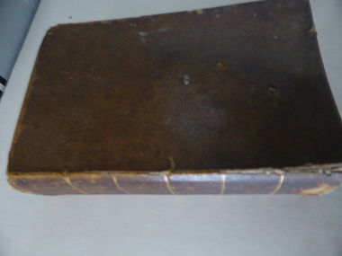
Book, A Complete Epitome of Practical Navigation - J W Norie, 1848
... It belonged to John Cowtan who held land near the Cassady's Bridge area in Caramut Road today (he was related to the Cassady family) and who is mainly important in the history of Port Fairy. Captain John Cowtan was a ship's master for John Griffiths...It belonged to John Cowtan who held land near the Cassady's Bridge area in Caramut Road today (he was related to the Cassady family) and who is mainly important in the history of Port Fairy. Captain John Cowtan was a ship's master for John Griffiths ...This book is a 19th Century treatise on aids to navigation. It belonged to John Cowtan who held land near the Cassady's Bridge area in Caramut Road today (he was related to the Cassady family) and who is mainly important in the history of Port Fairy. Captain John Cowtan was a ship's master for John Griffiths and a Launceston entrepreneur and ship owner between 1839 and 1844. In 1847 he went into partnership with John Bland, establishing a merchant's business with riverside buildings at the Port Fairy wharf. He left Port Fairy in the 1860s. The date of John Cowtan's signature in this book is 1849 (certainly a very early one in our history) and inside the front cover he has written notes about the local weather, mainly as it affected sailing conditions in late 1849 and early 1850. These notes are of great historical interestThis book is of great interest because it belonged to a Port Fairy historical figure and because of the hand written weather notes inside the front cover. This is a hard covered, leather bound book of 680 pages. It contains printed text, illustrations, tables, maps and sketches. One page is torn Some pages are stained. J Cowtan 1849john cowtan, port fairy -
 Warrnambool and District Historical Society Inc.
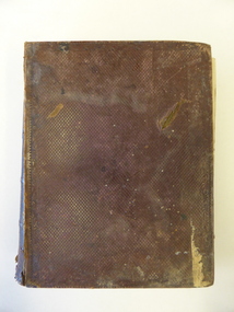
Book, The Domestic liturgy & family chaplain, 1846
... land that John Cowtan selected, was bought by William Cassady whose sister, Ann, was married to John Cowtan. Cassady established the property, Boughton where Cassady’s Bridge is today. This book came from a Cassady estate sale early in the 21st century. Between 1839 and 1844 John Cowtan was a ship’s captain for John Griffiths...land that John Cowtan selected, was bought by William Cassady whose sister, Ann, was married to John Cowtan. Cassady established the property, Boughton where Cassady’s Bridge is today. This book came from a Cassady estate sale early in the 21st century. Between 1839 and 1844 John Cowtan was a ship’s captain for John Griffiths ...This book belonged to John Cowtan. He was a purchaser of land near Cassady’s Bridge in Warrnambool and an important and early settler in Port Fairy. The land that John Cowtan selected, was bought by William Cassady whose sister, Ann, was married to John Cowtan. Cassady established the property, Boughton where Cassady’s Bridge is today. This book came from a Cassady estate sale early in the 21st century. Between 1839 and 1844 John Cowtan was a ship’s captain for John Griffiths, a ship owner and entrepreneur. In 1844, Cowtan established a merchant trading and produce business in Port Fairy with John Bland. In the 1860 John Cowtan went to live in Melbourne.This book is of great interest because of its early date (one year after the founding of Warrnambool) and because of its association with John Cowtan, a pioneer settler of Port Fairy with connections to Warrnambool.This is a brown leather covered book of 385 pages. The spine has gold lettering. The binding has come apart and has been mended with white cotton material on the inside of the cover. The insides of the cover have a brown, white, blue and yellow mottled pattern. The cover is stained and torn at the edges and has a deep gouging on the front. The first page has been torn and mended with tape and some of the pages are stained. There are two pressed fern fronds, one loose newspaper cutting and a bookmark with a sepia-coloured image, lace paper edges and coloured embroidery contained within the pages. The book has a preface and 58 chapters. The inscription is handwritten in black ink. ‘J. Cowtan 1848’ john cowtan, port fairy history, william cassady -
 Federation University Historical Collection
Document, Zelda Martin, Central Victorian Goldmining towns - Boom Towns or Ghost Towns?, c1996
... Griffiths, Melb. Friends of the State Library, 1989 +"The Public Lands of Australia Felix"; settlement and land appraisal in Victoria1834-91 with special reference to the Western Plains", J.M.Powell, Melb. ...Griffiths, Melb. Friends of the State Library, 1989 +"The Public Lands of Australia Felix"; settlement and land appraisal in Victoria1834-91 with special reference to the Western Plains", J.M.Powell, Melb. ...Zelda Martin was a PhD candidate at the University of Melbourne.[.1] 4th item in light blue display book titled Research Approach/Overview of Chapters/Confirmation of Canditure/Chapters1,2,3&4 of proposed thesis. *Twenty-seven page article on Victorian goldfields towns titled: Central Victorian Goldmining Towns - Boom Towns or Ghost Towns. The article was written during the author's PhD study. It outlines the context methodology, and resources and the chapters of the proposed thesis: (1) Central Victorian Goldmining Towns - The Context (2) Contemporary Views of the Factors Necessary for Town Growth (3) Outward Manifestations of Town Growth (4) The Trappings of Government (5-9) The Main Towns and Their Hinterland. [.2] 5th item in Light Blue display book as above item. *Chapter 1 of proposed thesis titled 'Pick, Shovel and Tin Dish Mining.' Covers in Section A: Central Victoria - Pre 1851: Aborigines in Central Victoria, Squatters, and Government. Section B: The years 1851-1854: The Early Gold Rushes, Government Reaction, Township Surveys, Legislation, Town Development, Local Government and Early Settlement. [.3] 6th item in Light Blue display book as above item. *2A of proposed thesis titled 'Contemporary Views of the Factors Necessary for Town Growth'. Similar information to Chapter 1 plus extra re towns and maps. Sections: Introduction, Context of Place - Geographical Towns Listed, The Context of Time - Pre1851 Aborigines, Governance of Port Phillip, The Squatters, The Villages of Central Victorian Highlands, Conclusion, Condensed Version of Chapter2B. [.4] 7th item in Light Blue display book as above item. *Chapter2B of proposed thesis. Sections: Area of Research, Schools, Banks, Newspapers, Progress Association, Town Development - Sandhurst (Bendigo), Ballarat, Castlemaine,, Maryborough, Ararat and Stawell. [.5] 8th item in Light Blue display book as above item. *Chapter 3 of proposed thesis titled 'Outward Manifestations of Town Growth'. Sections: Introduction, Contemporary Writing, Educationalists, The Bankers, The Townsfolk, Current Theory, General Theories of Urban Development, and Conclusion. [.6] 9th item in Light Blue display book as above item. *Chapter 4 of proposed thesis titled 'Trappings of Government' Sections: Introduction, Early Government Attitudes to Mining and Town Development, Law and Order, Township Surveys, Legislation, Local Government, Transport and Communication, The People and Lobbyists. [.7] 10th item in Light Blue display book as above item. *'The Rise and Fall of Central Victorian Goldmining Towns'. Includes a map showing main Goldfields, a table showing towns and villages at two points in time - 1857 and 1871; a Bibliography of Primary and Secondary Sources. [.8] Resource No1. Black display book titled Local Towns 1 : Alma: *Brief history *Directory *Maps Amphitheatre / Mountain Hut: *Brief History Post Office Directory Ararat: *Brief History *Post Office Directory 1869 - Alphabetical Listing by Occupation *Ararat - Prominent Citizens of 1858 *Langi-Morgala Museum Avoca: *Brief History *Excerpts from 'Avoca The Early Years', Margery and Betty Beavis; pg1 - Beginnings; pg11 - The Midas Touch; pg25 - Local Gold Escorts; pg27 - A Town is Born; pg51- The Administration of Justice; pg53 - The Ways of the Law; pg61 - News of the Day; pg65 - A Time to Play; pg72 - Land Ownership *Post Office Directory (Bailliere's) 1869 *Tourism Map and Information of area *Historic Avoca - A 5.5km Tour *Avoca & the Pyrenees Region - information pamphlet Ballarat: *Early History of Ballarat - Ballarat Historical Society, Publication No.1: origin of the name; Ballaarat - the Beginning; Fabulous Yields from the Ballaarat Goldfield; *Streetscape Lydiard Street. *Hand drawn map showing Leigh River, Old Portland Bay Road, plaque on road to Colac; etc. *Newspaper article re 'The Theatre Royal' ( which stood in the vicinity of the current Owen Williams store) - 'The News'15/04/1998 *Article - 'Ballarat's Mechanics' Institute Lives On' Ballarat Courier, 14/09/1985 *Article - Standing the Test of Time' The News 17/11/1993 re The Mechanics Institute & picture of the Reading Room *'Ballarat a Study of a City, Phyllis Reichl, pub. Nelson, 1968; no.3 place, time and people field studies series *Investigator Vol.33 No.2, 1998 Geelong Historical Society. Article on pg75 describes Ballarat in 1861 *Folded poster - 'Ballarat 100' a history of telegraph communication, pub. Telecom. Beaufort (Fiery Creek): *Brief history *Post Office Directory [.9] Resource No.2 Black Folder Titled Towns cont.No2 Bendigo (Sandhurst): *'Family & Local History at the Bendigo Library - 1851-2001 150 years of gold'. *Bendigo Government Camp in 1853 illustration; key to sketch and names of Government officers stationed there *Excerpts from 'Bendigo and Vicinity' Adolph Haman *The Bendigo Goldfield Registry - pgs 1-7 Introduction *Excerpt: 'Breaking the Grip' *Excerpt: The Most Go-Ahead Place *Excerpts from 'History of Bendigo' - anti license agitation; laying out of town; proposed railway; gold calls and dividends; the Sandhurst Municipality; journalism *Bibliography Blackwood: *Excerpts from 'Aspects of Early Blackwood - The Goldfield, the Landmarks, the Pioneers' Alan J Buckingham and Margaret F Hitchcock, JG Publishing,1980 Buninyong: *A Brief History *Investigator Vol1 No.2 Feb 1966 Geelong Historical Society. Pg3 - Article re gold escort route - Mt Alexander to Adelaide - (see a simple monument on the Western Highway a few miles out of Horsham. Pg 15 - Ballarat Excursion - re the finding of gold. *Three articles published by Buninyong and District Historical Society Inc: (Magpie Exploration; Finding Gold In The Green Hills; Magpie Exploration; Burnt Bridge to Cargarie to Mt Mercer) *Copies of newspaper articles/items *Buninyong Street Directory Carisbrook: *In the Beginning There Was Carisbrook *The History of the Carisbrook Racecourse Carngham / Snake Valley: *Brief History *Directory Castlemaine: *Directory 1865-1866 - Alphabetical and Street *Poster - Castlemaine A Contemporary Guide "The Great Centre" 1866 - A Contemporary Guide to the Fascinating Past *Pamphlet - Castlemaine District Community Hospital *Map - Castlemaine, Maldon & Surrounding Districts *Map and Information - The Dry Diggings Track - a 55kl walk among historic goldfields relics ( Castlemaine Fryerstown Vaughan Mt Franklin Hepburn Daylesford) *Postcard - Former Court House *Directory 1867 - Alphabetical, Trade [.10] Resource No.3 Grey folder Titled Towns 3 Creswick to Maryborough Creswick: *Brief History *Booklet - "Creswick Cemetery Walk" *Booklet - The Buried Rivers of Gold Heritage Trail Creswick *Creswick Historical Museum Information Sheet *Chronological History of Creswick *Alphabetical Directory of the Borough of Creswick *Creswick's Creek Directory 1856 *Historic Creswick Walking Tour *A Brief Account of the Schools of Creswick - Past and Present *100 Years of Railway Travel in Creswick *The Berry Deep Leads *The Spence Home at Jackass Gully in the Creswick State Forest ( William Guthrie Spence - Pioneer) *The New Australian Mine and the 1882 Disaster *Creswick District News, Issue 7, July August 1999 *The Creswick Miners Walk - Information and Map *Maps Chewton: *Brief History *Directory Clunes: *Brief History *Clunes Street Directory Daylesford: *Brief History *Notable Bushfires in Daylesford District Over More Than a Century - "Black Thursday" 1851; 1862; 1899; the Disastrous Hepburn Fire of 1906; 1939; 1944; 1969. *Post Office Directory -Daylesford and Hepburn Dunolly / Inkerman: *Brief History *Directory *Pamphlet - Goldfields Historical Museum *Pamphlet - Historic Dunolly - Victoria's Best Kept Secret *Map of Gold Workings at Dunolly Area - showing where the main gold rushes occurred *Brief History - Inglewood *Directory - Inglewood - Name Occupation, Dwelling Kingower: *Brief History *Directory - Name / Ocupation / Dwelling Linton / Happy Valley / Piggoreet: *Brief History *Directory - Lintons McIvor: *"A History of the Shire and the Township of Heathcote" by J.O. Randell Majorca: *Brief History *Official Post Office Directory 1869 - Name / Occupation/ Address Maldon (Tarrangower): *Brief History Part 1 *Brief History Part 2 *Post Office Directory *List - Alphabetical Order by Names plus Business and Trade (Tarrangower Times Oct/1858) *List - Alphabetical Order by Trade plus Name and Business *Directory - Name / Occupation / Dwelling Maryborough: *Worsley Cottage - built by Arthur Worsley, a contractor in stonework in 1894 [.11] Resource No. 4 Blue Display Book titled Towns 4 Moliagul to Stawell Moliagul: *Brief History *Moligul Legislative Assembly (Voting?) List - Names and Occupations *Moliagul Victorian Post Office Directory 1868 - Name / Ocupation / Address / Comments *"The Welcome Stranger" gold nugget *The Sunday School *The Welcome Stranger Discovery Walk - information and map Moonambel (Mountain Creek) Redbank *Brief History *List of names extracted from advertisments of the Pioneer and Mountain Creek Advertiser 16/02/1861. *Bailliere's Directory 1869 - Alphabetical List of Name / Occupation / Place St Arnaud: *Brief History Sebastapol: *Brief History *Directory 1869 - Alphabetical by Name; plus occupation and address. Browns and Scarsdale: *Brief History *Browns Street Directory - Name and Occupation Smythesdale: *Brief Description *Smythesdale Street Directory -Name and Occupation Stawell (Pleasant Creek) *Brief History *Victorian Official Post Office Directory - Name /Occupation / Dwelling *Chronology - 1841-1920 *Production of gold statistics - 1879 - 1900 *Big Hill *Extracts from "The Golden Years of Stawell". Chapt 1 - Stawell's Coming Out. Capt. 2 - The Gold Rush. Caapt.3 - Cradle of Democracy. Chapt.4 - The Reefs Becomes Stawell. Chapt. 5 - Rushing In. Chapt.6 - The Pioneers. Chapt 7 - The Decade of Optimism. [.12] Resource No. 5: Blue Display Book titled 'Towns Steiglitz to the The Golden Triangle. Steiglitz: Brief History Victorian Post Office Directory 1869 *Map of Steiglitz *List of maps relevant to Steiglitz history *Information 6 tables of data from "Reports of Mining Surveyors Talbot (Back Creek) Brief History Taradale: Post office Directory 1869 - Name/Occupation/Street. Also list in alphabetical order by Occupation Taradale *Chronological Reference to Taradale Mines *Water - The Coliban System of Waterworks *Joseph Brady *The Syphon Tarnagulla (Sandy Creek) *Brief History *Tarnagulla Businessmen Cameos to give depth to advertisments in 'The Tarnagulla Courier' various issues 1864-1871 *Directory - Name/Occupation /Address *List - Name/Business/Trade Wedderburn (Koorong) *Brief History *List - Name/Occupation The Golden Triangle: *The Early Rushes - Wedderburn / Moliagul / Sandy Creek - Tarnagulla / Jones Creek - Waanyarra / Kingower / Dunolly - Goldsborough / Inglweood *Census of 1857 - Population / Occupations *1858-1871 - A Time of Consolidation- Wedderburn / Moliagul / Sandy Creek- Tarnagulla / Arnold *Census 1871 - Population *Information gleaned from the census data - Demographics / Population / Occupations / marital / Birthplace / Religion / Literacy/ Occupation and Housing Cameos *Graphs - Birthplace of settlers /Male-Female Ratio / Married males / Children under 15 as Percentage of Population / Religion *Census 1857 - Statistical data *Maps *Bibliography [.13] Resource No. 6 - Black Display Book Information and Research in Central Victoria including: *Banking - Research from ANZ Bank Archives *Institutions - also includes articles listed from the Ballarat Times Newspaper *Australian mining History Association - A.M.H.A. Bibliography *Australia's Mining History * Bibliography - Land Surveys Victoria - *1853 Administration (Statistics and Other) includes: schools / ministers of religion / police / military / local administration / licences for sale of spirits / distances between various Victorian gold fields. * Victoria Government Gazette (Copy) - N0. 116, 12/12/1854 includes: Gold Felds Commission of Enquiry & No. 85, 15/09/1854 - Addresses presented to the Lieutenant Governor (Sir Charles Hotham) during his tour through the Gold Fields of Victoria,1854. Addresses on behalf of : the people of Bendigo; Members of the Church of England, Bendigo; Members of the Wesleyan Church on the Bendigo Gold Fields; Bendigo Gold District General Hospital; the Bendigo Prospecting Association; Committee of the Bendigo Local Exhibition; Bendigo District Medical Association; Coloured Americans Resident at Bendigo; German Inhabitants of Bendigo; Landowners, Inhabitants, and Miners of Castlemaine; Inhabitants of Forest Creek; Inhabitants of Heathcote and Gold Miners of McIvor; Residents and landholders of the District of Bacchus Marsh; Inhabitants of Kilmore and Vicinity. *Gold Fields Correspondence 1853: letter from Lieutenant Colonel Valiant, (Officer commanding the Troops in Victoria) to the Lieutenant Governor re threatened disturbance at Sandhurst (Bendigo) regarding the Gold License Fee. * Extracts from a book "Victoria" re Gold Fields Commission of Enquiry involving mainly Ballarat and Castlemaine and a chapter titled 'A Tour to the Victorian Gold-Fields' *Lists of central Victorian newspapers - listed by date published 1851to 1874; by first date available to State Library. *A list of cities and towns showing County, population in 1861 &1871, and municipal status. [.14] Resource no.7. Black display book. *Reference: Papers presented to Parliament Victoria - 1859-1860 4 volumes - relevant sections copied. Contains information on Branches of Government. General / Finance / Gold / Gazette / Commission and Warrant / Statistic. *Gold Fields Act. In accordance with the Act the gold fields are divided into six districts - Ballaarat, Castlemaine , Sandhurst, Avoca, Ararat, and Beechworth.. Official staff in each gold district consists of a Resident Warden, Wardens, Wardens' Clerks, Bailiffs, Chinese Protectors, Chinese Interpreters, and Mining Surveyors. *Gold Receiver *Gaols *Police magistrates and Clerks of Petty Sessions, etc. *Field Branch *Immigration and Emigration Overland - Chinese - 1859 *Population on the Goldfields *The Geological Survey - The Government Geologist is assisited by staff from four branches - the office Branch; the Publishing Branch; the Field Branch and the Museum Branch. *Commission to Enquire Into Sludge dated 10/02/1859 (Some sections copied) - Report to the Honorable Chief Commissioner of Public Works, Melbourne re the mode of carrying the sludge from the puddling mills in Sandhurst without interfering with the drainage of the town and the roads in the neighbourhood. [.15] Resource No.8: Camel display book titled Resource No. 8. Aborigines *Lists of book titles - +"Readings in Victorian prehistory" +"The Aborigines of Port Phillip" +Aboriginal languages and clans" +"A History of the Port Phillip District" +"Langi Ghiran 1: Aboriginal Rock...." +"Koorie History: sources for aboriginal studies in the State Library of Victoria", ed. Tom Griffiths, Melb. Friends of the State Library, 1989 +"The Public Lands of Australia Felix"; settlement and land appraisal in Victoria1834-91 with special reference to the Western Plains", J.M.Powell, Melb. Oxford University Press 1970 +*Bibliography of the Victorian Aborigines' from the earliest manuscripts to 31st December 1970, Massoa, Aldo, Melb. Hawthorn Press, 1971 +"Aborigines in Colonial Victoria, 1836-1886", M.F. Christie, Sydney University Press, 1979 +"Urban and Industrial Australia: readings in Human Geography" ed J.M. Powell, Melb. Sorrett Pub. 1974 *Extracts: -Processes of Pioneer Settlement - The Squatting Occupation of Victoria, 1834-60. J.M. Powell -Areal Variations in the Class Structure of the Central-Place Hierarchy. P. Scott - Volume1 and Volume 2: Notes Relating to the Habits of the Natives of Other Parts of Australia and Tasmania. Compiled from various sources for the Government of Victoria by R Brough Smyth. John Curry, O'Neil, Melb. 1st pub. Melb. 1876. p31-45 - Numbers and Distribution of the Aborigines in Victoria -Victorian Aborigines 1835-1901 - A Resource Guide to the Holdings of the Public Record Office, Victoria; published by the Government Information Centre 1984. *History of the Aboriginal Artefacts Displayed in the Daylesford Museum. F. G. Powell (4 page pamphlet) *Letter to Zelda Martin from Peter Lovett, Cultural Officer, Ballarat & District Aboriginal Co- Operative, 05/02/1997 *Map: Ian Clarke Victorian Tribunal Boundary Map - Clans of Central Victoria. *Victorian Rock Art and Mythology - Article about Mount Langhi Ghiran and myths of the Tjapwarong people. *Two Aboriginal myths relating to the Grampians - 'The Monster Emu' / 'The Aquisition of Fire', by the Aborigines in the Grampians Areas *Article titled (chapter 8) Ballarat - information re camping sites in the region. Lake Wendouree / Lake Burrumbeet (includes a myth) / Mt Bunninyong / Lal Lal / Pitfield / Mount Elephant / Mount Egerton / Meredith / Lake Goldsmith / Lake Learmonth / Ercildoune *Notes on the Aborigines of the Wider Ballarat Region plus European names=Aboriginal names. John Morris 26/07/1995 *Role of Aborigines in Town Development in Central Victoria. Mentions Native Police Force est. in Port Phillip 1842 and Central Board for Aborigines est. 1860 *The Grave of King Billy. (Frank Wilson) Pamphlet. *Camping Places in Central and Northern Victoria. Article re Lake Burrumbeet site. *Programme for the Unveiling of Memorial Cairn for Edward Stone Parker 1802-1865. Note portrait not accurate. Accurate portrait is available in the book "A Successful Failure A Trilogy The Aborigines and Early Settlers", Edgar Morrison, Graffiti Publications, 2002. * Large envelope addressed to Mr G Netherway containing newspaper cuttings regarding the life of Edward Stone Parker, the unveiling of the Memorial Cairn as mentioned above, articles titled 'Episodes from Our Early Days' (Edgar Morrison, Yandoit)- The Black's School, A School At Last and The Final years. Also a typed page titled 'Historical Background to E.S.Parker's Career. Includes an interesting tale titled 'When the cat lay doggo' re laying power leads for the unveiling ceremony at the memorial site. [.16] green display folder titled 'Research Aids' *List of references to Commissioners' & W'ardens' Reports (formerly held at La Trobe Library Archives, now at Public Records Office [PRO]). Indicates town referred to / date of report / name of camp if different to town. * Archive information re Anglican Records *Movement around the Goldfields - Miners and Storekeepers - usefulness of newspapers in providing information - areas covered - Castlemaine, Maldon, Ararat, Stawell, Tarnagulla, Dunolly. *Port Phillip /Victoria Directories 1839/1867 - Chronological list of Directories included in this series. *"Notes on the History of Local Government in Victoria" A.W. Greig Melb. University Press 1925 - Photo-copied extract p5-p40. (Source - Deakin University Library) - Introduction by W.Harrison Moore. Section 1 - Development in New South Wales Before Separation. Section 2 - Development in Victoria After Its Separation from New South Wales. Hand written notations: 'roads, markets, and local government 1855 on' ;'opportunity of squatters in parliament' and 'opportunities of matters in parliament p33' * Notes on the Establishment of Surveyor General's Department 1851and Commissioner of Crown Lands and Survey. * Newspaper articles from The Argus, 1849, re the discovery of gold in the Pyrenees region. * Excerpt - a report on schools - A.B.Orlebar, Inspector; re the need for permanent school buildings rather than tents. *Excerpt from - 'Approaches to Urban History', Sean Glynn: The Case for Caution * Except from - 'The Urban Sprinkle', Weston Bate: Country Towns and Australian Regional History *Reference- 'The History of Land Tenure in the Colony of Victoria', John Quick. References the Haines Land Bill, land tenure and Land Leagues. [.17] Light blue envelope folder titled 'Birtchnell's Ballarat, etc. Directory 1862 *Contains various directories for Smythesdale, Buninyong, Clunes, Brown's and Creswick. [.18] Red envelope folder no.2 titled Victorian Gazetteer *Selected pages from 1869 Victorian Gazetteer on A4 paper (with a handwritten note questioning if some pages are from 1868 Victorian Gazetteer as appears to be different sizes - A3 pages.) Information includes locations and descriptions of towns, hotels, banks, communications and populations. (Does not include names, residences and occupations) [.19] Red Envelope folder titled Bailliere's Official Post Office Directory 1868 (or1869 or a mixture of both?) *Preface *Contains a selection of pages of towns highlighted in yellow in the the index *Work on this directory was commenced in 1867. *Information includes: Municipalities - mayors and councilors; lists of towns naming male inhabitants and their occupations. [.20]Yellow manila folder titled Post Grad Seminar Presentation 1996 *Gives some background to Zelda Martin's proposed thesis and why she chose the topic Gold Mining Towns Boom or Bust [.21] A3 display book - No. 1A * A list of 'Relevant Newspapers collected: The Tarrangower Times and Maldon Advertiser (first published 1858) Includes dates 1858-1867. The Mount Alexander Mail. Includes dates 1854-1866 The Tarnagulla Courier. Includes dates from1864-1871 Dunolly and Burnt Creek Express. Includes dates from 1862-1871 * Selection of newspaper pages from The Mount Alexander Mail 1854 to 1856, mostly showing advertisements for businesses and services provided to that community. [.22] A3 display book - No. 1B * Selection of newspaper pages from The Mount Alexander Mail 1857 to 1866, mostly showing advertisements for businesses and services provided to that community. [.23] A3 display book -No. 2 * Selection of newspaper pages from The Tarnagulla Courier 1864 to 1871, mostly showing advertisements for businesses and services provided to that community. [.24] A3 display book - No. 3 *Selection of newspaper pages from The Tarrangower Times (and Maldon and Newstead) Advertiser 1858 to1867, mostly showing advertisements for businesses and services provided to that community. [.25] A3 display book - No.4 * Selection of newspaper pages from The Dunolly and Burnt Creek Express; and The Dunolly and Betbetshire Express 1862 to 1871, mostly showing advertisements for businesses and services provided for that community. [.26] A3 display book - No.5 Includes: * Bryce Ross's Diggings Directory. Includes instructions for using this directory. This directory was used by "all persons having connexion or desiring to communicate with 'working parties, private friends, or Stores at the Diggings." As a directory for each area wwas completed it was published in each month's issue of Bonwick's "Digger's Magazine." Years c1852/1853. This Directory commences first at the head of Forest Creek. Includes a directory for Bendigo and Ballarat. Of interest at the end of the Bendigo and Ballarat directory is a list of the number of storekeepers, butchers, doctors, smiths, eating houses, lemonade sellers and chapels. * The Castlemaine Directory and Book of General Information Comprehending Glass's Model Calendar for the Two Years 1862 and1863. "zelda martin, victorian goldfield towns, bendigo, castlemaine, ballarat, maldon, stawell, ararat, maryborough, creswick, avoca, heathcote, banks, bank of australasia, union bank of australia, government camp, sandhurst, water supply, tarnagulla, talbot, back creek, mountain creek, police court, carisbrook, dunolly, thompson's foundry, charles clacy, anthony trollope, robert cecil, mount alexander, urbanisation, national schools, education, govenrment, industry, railway, transport, settlement, land settlement in central victoria, steiglitz, joseph brady, the new australian mine, berry deep leads, william guthrie spence, creswick state forest, arthur worsley, worsley cottage, the welcome stranger, moliagul, moonambel, redbank, st arnaud, sebastapol, brown's, scarsdale, clunes, chewton, daylesford, bushfires, inkerman, inglewood, kingower, lintons, happy valley, piggoreet, mcivor, majorca, tarrangower, taradale, the coliban system, the syphon, sandy creek, wedderburn, koorong, arnold, jones creek, waanyarra, the golden triangle, census 1857, blackwood, buninyong, durham lead, magpie, carngham, snake valley, alma, amherst, daisy hill, amphitheatre, mountain hut, beaufort, fiery creek, counties, population, gold fields commission of enquiry1854, william westgarth, gold license fee, lieutenant colonel valiant, administration of the victorian gold fields, commission to enquire into sludge 1859, e.s. parker, edward stone parker, edgar morrison, mount franklin protectorate, dja dja wurrung, memorial cairn, franklinford, mt franklin memorial cairn, jajowurrong, dja dja wurung, tjaowarong, wothowurong, assistant protectors, daylesford museum, buluk, rock art - grampians, aboriginal mythology - grampians, aborigines, first nations people, mount franklin, aboriginal artifacts, lake burrumbeet, native police force, central board of aborigines, yandoit, commissioners' reports, wardens' reports, port phillip/victoria directories 1839-1867, local government - victoria 1853/1854, surveyor general's department - 1850's, victorian schools 1850's, a.b.orlebar, haines land bill, william charles haines, wilson gray, land tenure, land leagues, victorian gazetteer, the tarrangower times and maldon advertiser - 1858-1867, the mount alexander mail 1854-1866, the tarnagulla courier 1864, dunolly and burnt creek express 1862-1871, bryce rose's diggings directory, the castlemaine directory 1862-1863 -
 Eltham District Historical Society Inc
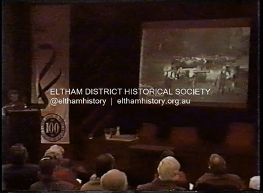
Film - Video (DVD), Melbourne and Metropolitan Board of Works, Yarra River Conference Proceedings; a Board of Works centenary event, 13-16 April 1991
... land for open space; further augmentation of water supply system; birth of containerisation changes the port; environmental concerns gain momentum. Speakers Dr Tony Dingle *, Department of Economic History, Monash University Dr Carolyn Rasmussen *, History Consultant Prof. Graeme Davison, History Department, Monash University Mr. Tom Griffiths...land for open space; further augmentation of water supply system; birth of containerisation changes the port; environmental concerns gain momentum. Speakers Dr Tony Dingle *, Department of Economic History, Monash University Dr Carolyn Rasmussen *, History Consultant Prof. Graeme Davison, History Department, Monash University Mr. Tom Griffiths ...Yarra River Conference History Segment [Noted on VHS tape jackets "Due to unavoidable circumstances, the quality of these tapes in some setions is less than desired."] The Yarra River Conference, organised by the Board of Works as part of the Centenary Celebrations, was held in the Board's Head Office Theatrette from 13-16 April, 1991. A segment of the Conference focussed on the role that the Yarra River has played in relation to the historical development of Melbourne. Conceived and presented by a group of prominent historians as a chronological 'trip down the river in time', and profusely illustrated with slides, this segment traced the various impacts that urban and rural growth, development of marine commerce, recreational uses, and environmental problems have had on the Yarra during a century and a half of European occupation. As no formal written paper of this combined presentation is available, these two video-tapes provide a record for anyone who has an interest in tis fascinating aspect of the Yarra's history. The speakers who combined to present this segment are identified on the cover of Tape 2. Tape 1 (2 hours) 1838-1863 Deputy ?? to Utility Early navigators of the Yarra River; developing the port of Melbourne; the gold rush and its effect on the new colony; punts and bridges; water supply; pollution of the Yarra; the discovery of gold and early settlement of the Yarra valley; floods of 1839 and 1863. 1863-1891 Formation of the Harbour Trust; Coode Canal; pollution of the Yarra by industry; aborigines, gold miners, timber getters in the Upper Yarra areas; bridges; the flood of 1891. Tape 2 ( 1 1/2 hours) 1892-1934: People Begin to See Beauty and Romance to the River Henley-on-Yarra; realignment of the Yarra; MMBW is responsible for a sewerage system; new docks to cope with increased overseas trade; development of recreational parks; new reservoirs; timber production and timber tramways; bushfire; flood of 1934. 1935-1970: The River is Neglected Still, Except When it Proves Useful Bushfirs of 1939; the end of many sawmills; birth of tourism; increased interest in conservation and preservation of land for open space; further augmentation of water supply system; birth of containerisation changes the port; environmental concerns gain momentum. Speakers Dr Tony Dingle *, Department of Economic History, Monash University Dr Carolyn Rasmussen *, History Consultant Prof. Graeme Davison, History Department, Monash University Mr. Tom Griffiths, Lecturer in Public History, Monash Uiversity Mr. Patrick Miller, History Consultant Mr. Colin Jones, Author and Historian * Co-authors of the Board's history, 'Vital Connections'.video recording, yarra river, conference proceedings -
 Eltham District Historical Society Inc
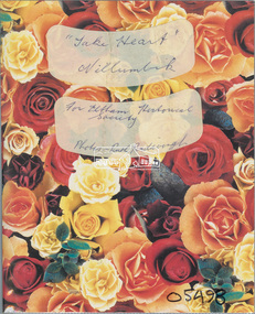
Album - Photo Album, Ruth Pendavingh, Take Heart, Nillumbik, 1998-2002
... Eltham District Historical Society Inc 728 Main Rd Eltham melbourne Album of photographs associated with activities of the Cardiac Rehab "Take Heart" Group including the Arthritis Group (Land and Water exercise) managed by Eltham Community Health Centre Allied Health Assistant Arthritis Group (Land and Water Exercise) Arthritis Group Arthurs Creek Betty Willis Bundoora Park Cardiac Rehab 'Take Heart' Group Christmas Break-up diamond valley railway Dirk Pendavingh Elizabeth Dick Eltham Community Health Centre Eltham Health Group Eltham Leisure Centre Eltham Lower Park Eltham Ernie Robinson Fairfield Park Fairfield Flagstaff Hill Griffiths Park Ken Willis Lavender Farm Migrant teachers Mt Cooper New Eltham Diabetes Contact Group Parkinson Support Group Picnic Ruth Pendavingh Scienceworks Sugarloaf Reservoir Veronica White-Hall warringal Water Exercise Group warrrnambool warrnambool RSL Floral print cover, 21.5 x 17.5 x 1.5 cm; 32 pages each containing two 10 x 15cm prints in platsic slips. 68 images Take Heart, Nillumbik Album Photo Album Ruth Pendavingh ...Album of photographs associated with activities of the Cardiac Rehab "Take Heart" Group including the Arthritis Group (Land and Water exercise) managed by Eltham Community Health Centre allied health assistant, arthritis group (land and water exercise), arthritis group, arthurs creek, betty willis, bundoora park, cardiac rehab 'take heart' group, christmas break-up, diamond valley railway, dirk pendavingh, elizabeth dick, eltham community health centre, eltham health group, eltham leisure centre, eltham lower park, eltham, ernie robinson, fairfield park, fairfield, flagstaff hill, griffiths park, ken willis, lavender farm, migrant teachers, mt cooper, new eltham diabetes contact group, parkinson support group, picnic, ruth pendavingh, scienceworks, sugarloaf reservoir, veronica white-hall, warringal, water exercise group, warrrnambool, warrnambool rsl -
Glen Eira Historical Society
Document - Hengar, Glen Eira Road, 356, Elsternwick
... land sale history since 1851 and gives a brief history of the occupancy of Hengar from 1888 to 1989. The file also includes one page of undated, unattributed handwritten working notes. Landells Rosalind Bullock Hilary Hengar Glen Eira Road Elsternwick Holloway J M Langdon Henry J Rosecraddock Beemery Park Estate Lirrewa Caulfield Town Hall Langdon Family Deanmead A Griffith Alfred Langdon E E Langdon H J Langdon Laura Langdon Henry Langdon Bessie Sadler Emily Amy Brenton V C Herz S Beth Riukan Girls’ College Happy Days Kindergarten Florence Herald Herbert Happy Days Child Minding Manners and customs Preschools Document Hengar, Glen Eira Road, 356, Elsternwick ...A copy of two page typed report by Hilary Bullock and Rosalind Landells, dated 18/01/1990, on the history of Hengar, a dower house built for the Langdon family in 1887/1888. The report includes an explanation of the term dower house, outlines the land sale history since 1851 and gives a brief history of the occupancy of Hengar from 1888 to 1989. The file also includes one page of undated, unattributed handwritten working notes.landells rosalind, bullock hilary, hengar, glen eira road, elsternwick, holloway j m, langdon henry j, rosecraddock, beemery park estate, lirrewa, caulfield town hall, langdon family, deanmead a, griffith alfred, langdon e e, langdon h j, langdon laura, langdon henry, langdon bessie, sadler emily amy, brenton v c, herz s, beth riukan girls’ college, happy days kindergarten, florence herald herbert, happy days child minding, manners and customs, preschools -
Glen Eira Historical Society
Article - Trinity Congregational Church, Glen Huntly
... land and church opening , small handdrawn map showing where church was before removal to current site. Reprinted articles from The Victorian Independant dated January 1910 and November 1909 on the opening of the Glen Huntly venture and the Revs who participated, and then the beginning of some committees, & Fellowship groups. Also mentions the appointment of Ivan Stebbins for six months. Trinity Congregational Church Glen Huntly Tennis Grange Road Mercy G.G. Bevan Dr. Primitive Methodist Church Dovan A. P. Rev. Holley J. J. Rev. Eastern Road. Freeman W Jones J. W. Rev. South Melbourne Griffith ...Handwritten undated notes (refer History of Primitive Methodism in Victoria and Tasmania – Rev. M Clarke). Article includes style of church building, history of building and interior decoration. Also includes history of some monetary donations, purchasing of land and church opening , small handdrawn map showing where church was before removal to current site. Reprinted articles from The Victorian Independant dated January 1910 and November 1909 on the opening of the Glen Huntly venture and the Revs who participated, and then the beginning of some committees, & Fellowship groups. Also mentions the appointment of Ivan Stebbins for six months.trinity congregational church, glen huntly, tennis, grange road, mercy g.g., bevan dr., primitive methodist church, dovan a. p. rev., holley j. j. rev., eastern road., freeman w, jones j. w. rev., south melbourne, griffith a. j. rev., devenish a. s. rev., lord. t, gosman dr, jones alfred., bryant. s, stebbins ivan, orr mr., billinghurst mr, copper mr, tregaskis mr., davidson mr., congregational hall, halls, wharington mrs., pavell g., rosstown, holden mr., bishop mr., sunday schools, white a. f., cockfield mr., orr mrs., billinghurst mrs., davidson mrs., o’ donnell miss, watkins miss., billinghurst miss., davidson miss., griffith mr., newing mr. -
 Phillip Island and District Historical Society Inc.
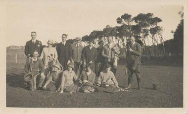
Photograph, Early 1920's
... The golf course in San Remo was opened in 1922 and was on the land adjacent to Ocean Grove where Griffiths point lodge and Davis Point road now stand. ...The golf course in San Remo was opened in 1922 and was on the land adjacent to Ocean Grove where Griffiths point lodge and Davis Point road now stand. ...One of 5 photographs donated by Lyn Chambers & Frank Dominick - Wonthaggi Historical Society The following information was sent by a reader of VC for which we are very thankful. The golf course in San Remo was opened in 1922 and was on the land adjacent to Ocean Grove where Griffiths point lodge and Davis Point road now stand. One hole was placed on the flat land on the beach. There were red flags and the cows used to eat them. Black & White photograph of a group of people with their golf clubs. Noted on back of photo "San Remo Golf Links". A question mark re location as it seems too flat. Maybe it was in Cowes?? This has now been updated - see below under "Historical Information" 4/9/2016On back: San Remo Golf Links early 1920'sgolf links san remo, lyn chambers -
Phillip Island and District Historical Society Inc.
Document
... John Hart and Griffiths Sealer/Whaler "Elizabeth" Synopsis of the life of John Hart. Sea Captain, Merchant Trader, Ship Owner, Over lander, Flour Miller and Politician. ...Letters from Victorian Pioneers 51. John Hart. The career of John Hart after leaving England as a boy and at 22 becoming a Commander of a Bass Strait Sealing Schooner. After losing much of his personal wealth, he lived in South Australia to become Premier three times from 1865 - 71. His association with Phillip Island was Shipping, bark to London.Synopsis of the life of John Hart. Sea Captain, Merchant Trader, Ship Owner, Over lander, Flour Miller and Politician. Born in England 1809, died in Adelaide 28th January, 1873. This article on John Hart was followed by an account of his writings October 1834 on his bark collection enterprise in Westernport and Phillip Island.First commercial venture in Westernport. John Hart and Griffiths Sealer/Whaler "Elizabeth"local history, documents, letters, john hart, politician, merchant trader, black & white photograph, miss elms san remo -
 Phillip Island and District Historical Society Inc.
Photograph Album, Kodak, Phillip Island Cemetery, c 1889
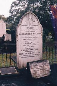
... land settlement of 1868. There are 6.2 acres of wetlands near the cemetery entrance. Phillip Island Cemetery Captain Alexander McLeod Susan McLeod Andrew McLeod Nancy McHaffie Edith Jeffery Captain McLeod: Captain McLeod and family kept the Post Office at Newhaven. He also built a boat called old "Trusty" and launched it almost opposite Churchill Island. Unfortunately, at a later date, the "Trusty" was the cause of a tragedy. The bottom of the boat had become so encrusted with marine growth that the owner decided to beach her between the jetties at Griffiths ...The Album was compiled by Nancy McHaffie late 1990's, with the assistance of Edith Jeffery's, with her book "Garden of Memories" and extensive knowledge of Phillip Island. The Cemetery lies back from the road and is surrounded by Manna Gums, rare Peppermint Gums, Blackwoods and other native trees. In all 25 acres of land were set aside as Crown Land in the land settlement of 1868. There are 6.2 acres of wetlands near the cemetery entrance.Captain McLeod: Captain McLeod and family kept the Post Office at Newhaven. He also built a boat called old "Trusty" and launched it almost opposite Churchill Island. Unfortunately, at a later date, the "Trusty" was the cause of a tragedy. The bottom of the boat had become so encrusted with marine growth that the owner decided to beach her between the jetties at Griffiths point, now San Remo. Before the job was completed the soring gave way and allowed the boat to tip over on her side, causing Captain McLeod to be crushed to death. Died March 3rd 1880 aged 64 years. Also buried in this grave is his wife Susan - died May 24th 1882 aged 62 years. Their son Andrew McLeod died February 21st 1916 aged 60 - loved husband of Elizabeth E McLeod. Alexander was Captain of the "Genista" for 12 years.phillip island cemetery, captain alexander mcleod, susan mcleod, andrew mcleod, nancy mchaffie, edith jeffery -
 Ringwood and District Historical Society
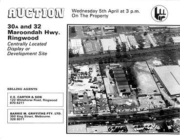
Flyer, Auction - 30A and 32 Maroondah Highway, Ringwood - 1978
... land leased to 30th November, 1979 with no option of renewal. Currently occupied by Bainbridge Motors; the frontage offers excellent highway exposure. Selling Agents - C.E. Carter & Son, 122 Whitehorse Road, Ringwood (Phone) 870 6211. Barrie M. Griffiths...land leased to 30th November, 1979 with no option of renewal. Currently occupied by Bainbridge Motors; the frontage offers excellent highway exposure. Selling Agents - C.E. Carter & Son, 122 Whitehorse Road, Ringwood (Phone) 870 6211. Barrie M. Griffiths ...Folded double-sided auction advertisement with black & white aerial and street views of development site for auction on Wednesday 5th April (1978).Land Details: 30A & 32 to be offered separately. No. 30A Certificate of Titles Vol 8981 Fol 900 and Vol 8247 Fol 255. No. 32 Certificate of Title Vol 9176 Fol 312. NB. Covenants on Title restrict the use of the land for the purpose of petrol filling station or for the sale of distribution of motor fuels lubricating oils or other petroleum products. Lease Details: 30A C/T 8981/900 - Vacant possession. 30A C/T 8247/255 - Leased to Burley Ice Rinks 20 years from 1st February, 1970 with 20 year option of renewal. 32 Front display area - Vacant possession. Buildings at rear of land leased to 30th November, 1979 with no option of renewal. Currently occupied by Bainbridge Motors; the frontage offers excellent highway exposure. Selling Agents - C.E. Carter & Son, 122 Whitehorse Road, Ringwood (Phone) 870 6211. Barrie M. Griffiths Pty. Ltd., 350 King Street, Melbourne (Phone) 328 8011. -
 Sunshine and District Historical Society Incorporated
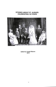
Document - Stories About St. Albans Celebrating 125 Years, Joseph "Joe" Ribarow, 2018 Revised and reprinted
... This attracted the new pioneers' families to the district, such as the McAuleys, Boyds, Andersons, Stevens, Colemans, Griffiths, McRaes, King and others to acquire land along Taylors Road and in the Western part of St. ...This attracted the new pioneers' families to the district, such as the McAuleys, Boyds, Andersons, Stevens, Colemans, Griffiths, McRaes, King and others to acquire land along Taylors Road and in the Western part of St. ...The most significant phase in the settlement of St. Albans occurred in the early 1900s when the Closer Settlement board subdivided Overnewton Estate into blocks of 200 to 300 acres and offered these for selection. This attracted the new pioneers' families to the district, such as the McAuleys, Boyds, Andersons, Stevens, Colemans, Griffiths, McRaes, King and others to acquire land along Taylors Road and in the Western part of St. Albans through to Sydenham.The stories in this document are about the families who are directly connected to the above era or came somewhat later, but all have contributed to the development of community. They are stories about transition of St. Albans from a sparse rural district to a number of crowded suburban neighborhoods.Stories About St. Albans Celebrating 125 Years Marion McAuley John Stevens Self and Goddard Jimmy Knowles Isabelle Davidson John Perrett Fred Barlowst. albans, john stevens, self and goddard, jimmy knowles, isabelle davidson, john perrett, fred barlow, marion mcauley -
National Vietnam Veterans Museum (NVVM)
Audio - Audio, CD, Photos from SVN 1971: land clearing and beast photos
... National Vietnam Veterans Museum (NVVM) 25 Veterans Drive Newhaven phillip-island-and-the-bass-coast Vietnam War 1961 - 1975 - Land clearing Package contains hardcopies of photos and donation note from Brian Griffith Photos from SVN 1971: land clearing and beast photos Audio Audio, CD Griffith, Brian ...Package contains hardcopies of photos and donation note from Brian Griffithvietnam war, 1961 - 1975 - land clearing -
 Dandenong & District Historical Society
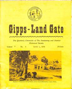
Journal, Dandenong & District Historical Society, Gipps-Land Gate Vol.7 No.3, 1979
... Londsdale Street Land For £££ The Name Of Griffith's Point Disappears Dandenong Granite Used In Princes Bridge Bid To Change Hampton Park's Name Fails A Cobb & Co Coach Driver From The Gold Era Harking Back 75 Years Ago Was This The Site Of Dandenong's First Market? ...Londsdale Street Land For £££ The Name Of Griffith's Point Disappears Dandenong Granite Used In Princes Bridge Bid To Change Hampton Park's Name Fails A Cobb & Co Coach Driver From The Gold Era Harking Back 75 Years Ago Was This The Site Of Dandenong's First Market? ...An interesting group of Early Dandenong Personalities, Places and EventsA5 size publication of the Gipps-Land Gate, April 1979, 16 pages, featuring an old picture of Dandenong on the cover. Keeping Posted The Beginnings Of Golf In Dandenong The Speculators Were Here Even In 1858! Londsdale Street Land For £££ The Name Of Griffith's Point Disappears Dandenong Granite Used In Princes Bridge Bid To Change Hampton Park's Name Fails A Cobb & Co Coach Driver From The Gold Era Harking Back 75 Years Ago Was This The Site Of Dandenong's First Market? A Day At The Eumemmerring Races Way Back in 1877 A Gippsland Railway Day To Be Remembered The Missing Link An interesting group of Early Dandenong Personalities, Places and Eventshotel history, early education in dandenong, interesting milestones, family histories -
 Whitehorse Historical Society Inc.
Correspondence, Documents re P.E. Eriksson property purchase, 1/03/1943
... land sales cooperative insurance company of australia Eriksson Pearl Eileen Warnes Road Mitcham No.30 Eriksson Edgar Invoice and receipt - property search for Mrs P.E. Eriksson from Flood & Permezel solicitors, Collins Street. Receipt for deposit from Frank Parker, Real Estate Agent. Title check and plan from Flood & Permezel. Copy, contract of sale - Insurance Policy Coop Insurance Co. Invoice Griffiths ...Invoice and receipt - property search for Mrs P.E. Eriksson from Flood & Permezel solicitors, Collins Street. Receipt for deposit from Frank Parker, Real Estate Agent. Title check and plan from Flood & Permezel. Copy, contract of sale - Insurance Policy Coop Insurance Co. Invoice Griffiths Bros, tea merchants Nov 1910 - Jan 1911 for Mrs A. Eriksson. Advice - certificate of title.w. h. flood & permezel, frank parker (real estate agent), land sales, cooperative insurance company of australia, eriksson pearl eileen, warnes road mitcham no.30, eriksson edgar -
 Whitehorse Historical Society Inc.
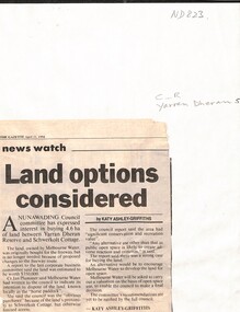
Newspaper - Article, Land options considered, 11/04/1994
... Article from the Gazette, 11 April 1994, on Nunawading Council interest in buying 4.6 ha. of land between Yarran Dheran and Schwerkolt Cottage from Melbourne Water by Katy Ahley- Griffiths....Whitehorse Historical Society Inc. 2-10 Deep Creek Road Mitcham melbourne yarran dheran schwerkolt cottage melbourne water Article from the Gazette, 11 April 1994, on Nunawading Council interest in buying 4.6 ha. of land between Yarran Dheran and Schwerkolt Cottage from Melbourne Water by Katy Ahley- Griffiths. Land options considered Newspaper Article ...Article from the Gazette, 11 April 1994, on Nunawading Council interest in buying 4.6 ha. of land between Yarran Dheran and Schwerkolt Cottage from Melbourne Water by Katy Ahley- Griffiths.yarran dheran, schwerkolt cottage, melbourne water -
 Bacchus Marsh & District Historical Society
Map, Glenvale Estate and Glenmore Estate Land Sales 1909
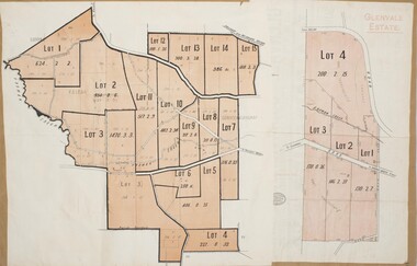
... The two land auction plans shown in this record relate to the sale of land from the Glenmore Estate property. The Glenmore property was established by C.J. (Charles James) Griffith and James Moore around 1840. ...Both parcels of land were originally part of the Glenmore Estate a pastoral holding belonging to C.J. Griffith and James Moore which the began in the Rowsley area south west of Bacchus Marsh in the 1840s. ...Both parcels of land were originally part of the Glenmore Estate a pastoral holding belonging to C.J. Griffith and James Moore which the began in the Rowsley area south west of Bacchus Marsh in the 1840s. ...The two land auction plans shown in this record relate to the sale of land from the Glenmore Estate property. The Glenmore property was established by C.J. (Charles James) Griffith and James Moore around 1840. Moore sold his interest to Moelesworth Greene in 1848. Greene was the nephew of the other owner Charles Griffith who died in 1863. From around the 1870s onwards parts of the Estate were subdivided and put up for sale or lease. In subsequent decades more changes in ownership occurred. These two plans document another major sale of the land from the original Glenmore Estate including part of the estate which had become used for dairy farming and was at that time known as the Glenvale Estate. Two single page maps pasted together on a single page of a bound volume of maps. One map shows 15 separate lots of land for sale. The other map which has the words 'Glenvale Estate' at the top of the map shows 4 lots of land for sale. Both parcels of land were originally part of the Glenmore Estate a pastoral holding belonging to C.J. Griffith and James Moore which the began in the Rowsley area south west of Bacchus Marsh in the 1840s. The maps are pasted into a bound volume containing 76 maps or plans in total. High resolution digital image stored on BMDHS computer network. bacchus marsh victoria maps, glenvale estate property, glenvale estate land sales, glenmore estate, glenmore station -
 Bacchus Marsh & District Historical Society
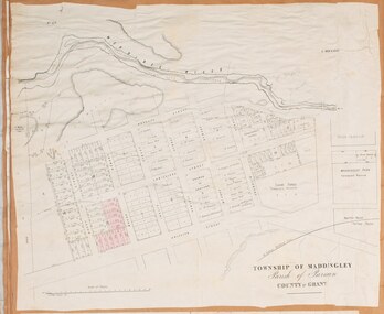
Map, Maddingley Township, Parish of Parwan, circa 1890s
... Griffith Street and Maddingley Road. Other streets visible are Franklin Street, Inglis Street, Labilliere Street, McCrae Street, Moore Street and part of Station Street. Bacchus Marsh Victoria Maps Maddingley Victoria Maps Land ...Maddingley is a locality or township within the broader township area of Bacchus Marsh. This map is not dated. However features in Maddingley which appeared in the 1880s and 1890s are present in the map, These include the Bacchus Marsh Railway Station and the Bacchus Marsh Showgrounds. The main residential and commercial area of Maddingley is shown on this map in an area bounded by Bacchus Street, Barry Street, Griffith Street and Maddingley Road. Other streets visible are Franklin Street, Inglis Street, Labilliere Street, McCrae Street, Moore Street and part of Station Street.A single page paper map showing land allotments, streets, rivers, creeks, park lands, the railway line and Bacchus Marsh railway station in the township of Maddingley. The map is pasted into a bound volume containing 76 maps or plans in total. bacchus marsh victoria maps, maddingley victoria maps, land use, maddingley victoria history -
 Bacchus Marsh & District Historical Society
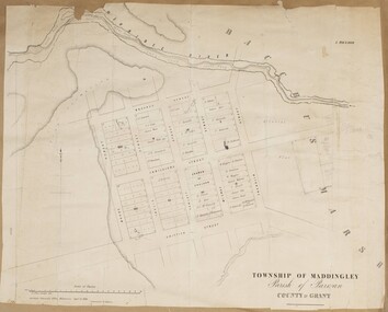
Map, Maddingley Township, Parish of Parwan, County of Grant, 1856
... Griffith Street and Franklin Street. Other streets visible are Inglis Street, Labilliere Street, McCrae Street. The area to the east of Franklin Street is not sub-divided and is described as an 'alluvial flat. Bacchus Marsh Victoria Maps Maddingley Victoria Maps Land ...Maddingley is a locality or township within the broader township area of Bacchus Marsh. This map is dated 1856 but is based on an earlier survey in 1843. The main area of Maddingley shown on this map is an area bounded by Bacchus Street, Moore Street, Griffith Street and Franklin Street. Other streets visible are Inglis Street, Labilliere Street, McCrae Street. The area to the east of Franklin Street is not sub-divided and is described as an 'alluvial flat. A single page paper map showing land allotments, streets, and natural watercourses in the township of Maddingley. The map is pasted into a bound volume containing 76 maps or plans in total. Two inscriptions: 1. A.J. Skene Surveyor, 1843. ; 2. Surveyor-General's Office Melbourne, Sept 6, 1856. (Lithographed by R. Meikle)bacchus marsh victoria maps, maddingley victoria maps, land use, maddingley victoria history -
![Map, Ballarat and Gordons Lane Plan of Land required [for railway line work]](/media/collectors/5e461d8021ea67224c82f2a1/items/676ff3a62c3783fe00b96a8d/item-media/676ff4a42c3783fe00b96cb6/item-fit-380x285.jpg?cb=6) Bacchus Marsh & District Historical Society
Bacchus Marsh & District Historical SocietyMap, Ballarat and Gordons Lane Plan of Land required [for railway line work]
... Single page map showing land required for railway line work near Griffith Street, Bacchus Marsh. ...Bacchus Marsh Victoria History Maddingley Victoria History Railway Lines Single page map showing land required for railway line work near Griffith Street, Bacchus Marsh. ...The railway line from Melbourne to Bacchus Marsh was completed in February 1887. After this date work continued to extend the line to Ballan. This map indicates a portion of land only a few hundred metres west of the Bacchus Marsh railway station which would have been among the first stages of the line to Ballan to have been constructed. This suggests the date of this map to be in the late 1880s.Single page map showing land required for railway line work near Griffith Street, Bacchus Marsh. Scale 10 chains to 1 inch. Hand-written on the map are the exact distances between Bacchus Marsh and Gordons (Gordon) and between Bacchus Marsh and Melbourne as measured from the corner of Maddingley Road and Station Street. Distances recorded are in miles, chains and links. The land required for the railway works is marked in red ink and runs through an area known as Kennedy's Gully. Part of a set of maps which are pasted into a bound volume containing 76 maps or plans in total. High resolution digital image stored on BMDHS computer network. bacchus marsh victoria history, maddingley victoria history, railway lines -
![Diary, [Digital file].1840-1841. Charles Griffith](/media/collectors/5e461d8021ea67224c82f2a1/items/67a209aff435c92f9910fa93/item-media/67a20ae0f435c92f9910fc3e/item-fit-380x285.jpg?cb=6) Bacchus Marsh & District Historical Society
Bacchus Marsh & District Historical SocietyDiary, [Digital file].1840-1841. Charles Griffith
... McKenzie who agreed to sell his land and sheep to Griffith and Moore. The property they acquired came to be known as Glenmore. ...McKenzie who agreed to sell his land and sheep to Griffith and Moore. The property they acquired came to be known as Glenmore. ...Charles Griffith was born in Kildare, Ireland in 1808. He studied at Trinity College, Dublin acquiring a B.A. in 1829 and an M.A. in 1832 before being admitted to practice as barister. In 1840 he emigrated to Australia arriving in the Port Phillip District in November 1840. Soon after arriving he and his friend James Moore formed a business partnership and acquired land in the Parwan Valley near Bacchus Marsh. This land had been in the possession of a Mr. McKenzie who agreed to sell his land and sheep to Griffith and Moore. The property they acquired came to be known as Glenmore. The partnership with James Moore lasted until 1848. In 1846, whilst in Ireland, Griffith married Miss Jane Catherine Magee, then returned to Glenmore and later took his nephew, Molesworth Richard Greene, into partnership, which arrangement proved to be long and prosperous. In 1857, they bought runs at Mount Hope and Mount Pyramid, which they kept until the days of free selection. Griffith led an active and successful public life. He was a member of the new Victorian Legislative Council in 1851, and was later an elected representative of the Legislative Assembly 1853-1859. He occupied many important public positions, including that of magistrate for Bacchus Marsh. Griffith was a devout Anglican and hosted Bishop Charles Perry at his station near Bacchus Marsh in 1849. He died in 1863 at his home in South Yarra. The diary is a detailed account of Griffith's voyage from Ireland to Australia and of his early months in Melbourne. After this it covers his early months establishing himself on his property, Glenmore, near Bacchus Marsh. The timeline of the diary stretches across 1840 and 1841. Griffith was an educated gentleman who made detailed observations about the environment he found himself in. The diary is particularly notable for Griffith's commentary about his interactions with people from first nations, and reveals some of his thinking about Colonial policies directed at first nations people. The diary also includes some sketches of individual first nations people along with some sketches of flora and fauna. The final part of the diary includes a glossary of Aboriginal words Griffith was familiar with. Digital file. PDF format. Digitised by State Library Victoria from photocopied pages of a hand-written transcription of the original diaries written by Charles J. (James) Griffith in 1840 and 1841.charles james griffith 1808-1863, diaries bacchus marsh, glenmore station, wadawurrung people, aboriginal australians bacchus marsh region history