Showing 40 items matching "historic mine site"
-
 Bendigo Historical Society Inc.
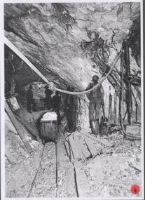
Photograph - Austin Collection: ore truck in drift, 1980's
... ...mine site...historic...History House 11 Mackenzie Street Bendigo goldfields mining underground miners Bendigo mine site historic mine site ore truck Black and white photograph: historic mine image shows ore truck being pushed along rail track in tunnel. ...Black and white photograph: historic mine image shows ore truck being pushed along rail track in tunnel. Miner on right hand side of image, standing with shovels, timber at his feet. Red dot with '4' bottom right hand corner, possibly used as identification in display. Mine not named but from Bendigo goldfield. mining, underground miners, bendigo, mine site, historic mine site, ore truck -
 Bendigo Historical Society Inc.
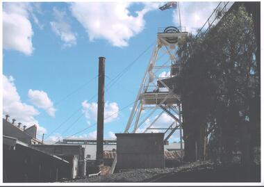
Photograph - AUSTIN COLLECTION: Central Deborah Gold Mine, 1980's
... ...mine site...historic...Between 1945-46 the company upgraded the mine with extensions to sheds and the installation of new steam machinery, electric air compressor, steel poppet head, and ore bins. mining Bendigo mine site historic mine site Central Deborah Gold Mine poppet head Colour photograph: metal mine chimney in centre of image, metal poppet head on right hand side. ...The Central Deborah Gold Mine, 76 Violet Street, Bendigo, was developed from 1939 and operated as a working mine until 1954. The mine was one of a minority that continued to function during the Second World War. In 1939 the mine boasted a small timber poppet head, boiler steam winch, compressor, blacksmith shop, store, change rooms, and offices. Between 1945-46 the company upgraded the mine with extensions to sheds and the installation of new steam machinery, electric air compressor, steel poppet head, and ore bins. Colour photograph: metal mine chimney in centre of image, metal poppet head on right hand side. Mine sheds on left of image, peppercorn trees on right. Australian flag flying from top of popper head. mining, bendigo, mine site, historic mine site, central deborah gold mine, poppet head -
 Bendigo Historical Society Inc.
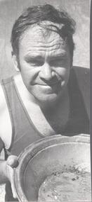
Photograph - Austin Collection: gold discovery, 1980's
... ...mine site...historic...History House 11 Mackenzie Street Bendigo goldfields mining underground miners Bendigo mine site historic mine site ore truck Collection of two black and white photographs of Ian Wemyss of Inglewood, with gold in a panning dish and a newspaper article regarding Ian's gold find. ...Collection of two black and white photographs of Ian Wemyss of Inglewood, with gold in a panning dish and a newspaper article regarding Ian's gold find. a. Ian Wemyss, wearing singlet, holding gold pan with specks of gold in bottom b. Ian operating sluice with water pumped from dam running down baffles back into dam c. Newspaper article 'Gold ...But life is tough' (newspaper unknown) relating the story of Ian finding gold. Ian and his partner 'Bob Dick of Rochester are using the only water in the area - an old mining dam beside the old Maxwell Extended mine, which was worked until the 1930's'. mining, underground miners, bendigo, mine site, historic mine site, ore truck -
 Ballarat Heritage Services
Photograph - Colour, Red, White and Blue Mine near Maldon, 2017, 17/10/2017
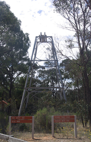
... Colour photograph of the Red, White and Blue historic mine site in the Muckleford State Forest, showing an intact poppet head with tubular steel legs, winding wheels and remains of timberwork....mine is a site of historical, areaological and scientific importance to Victoria, and is listed on the Victorian Heritage Register of significant heritage places. It was also known as the Golden Age Mine and as Malney's Red, White and Blue Mine. red, white and blue mine maldon golden age mine maloney's red, white and blue muckleford state forest Colour photograph of the Red, White and Blue historic mine site in the Muckleford State Forest, showing an intact poppet head with tubular steel legs, winding wheels and remains of timberwork. ...The Red, White and Blue mine is a site of historical, areaological and scientific importance to Victoria, and is listed on the Victorian Heritage Register of significant heritage places. It was also known as the Golden Age Mine and as Malney's Red, White and Blue Mine. Colour photograph of the Red, White and Blue historic mine site in the Muckleford State Forest, showing an intact poppet head with tubular steel legs, winding wheels and remains of timberwork.red, white and blue mine, maldon, golden age mine, maloney's red, white and blue, muckleford state forest -
 Bendigo Historical Society Inc.
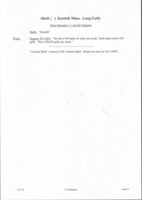
Document - MINING REPORTS - KENTISH MINE MANAGER'S REPORT
... (Extract from North West Victoria Historic Mine Sites, David Bannear, Heritage Victoria, 1991.)...(Extract from North West Victoria Historic Mine Sites, David Bannear, Heritage Victoria, 1991.) ...Here on the Garden Gully Line were Bell and Watson’s, the Cornish United, the Victory and George Lansell’s pride, the Pandora. Here too, was the enormously rich Kentish Mine from which its owner, J.B.Watson, was credited with taking some thirteen tons of gold, then worth £1,500,000. At this time, John Boyd Watson was well on the way to becoming not only the richest man in Sandhurst, but probably in the colony. (Extract from North West Victoria Historic Mine Sites, David Bannear, Heritage Victoria, 1991.)Handwritten extracts by Albert Richardson, with typed copy of same, from the Kentish Mine Manager, J. J. Jewell's Report. Extracts dated 1-11-1894 and 9-3-1894. Report mentions crushings and gold yield at the Old Carlisle Shaft and crushings and gold yield from The 'Central' mullock. (b) mentions the baling of water and the Carlisle Shaft, formerly Nth Garden Shaft.document, gold, mining reports, mining reports, kentish mine manager's report, j j jewell, old carlisle shaft, w griffiths & party, nth garden shaft, j cock & party, the 'central' -
 Federation University Historical Collection
Article - Article - Women, Ballarat College of Advanced Education: Anne Stewart; Librarianship Storyteller
... sites, gathered the children and told a story. A keen community player Anne E. Stewart has fulfilled a number of pro bono roles such as the President of the Australian Storytelling Guild (Vic Branch), and Council President of the Daylesford Primary School. Anne E. Stewart is a senior writer for the 'Swag of Yarns' and has worn the prestigious storytellers Cape at Dromkeen, an institution that nurtures and develops children's literature. Returning to her alma mater in 2007 Anne E. Stewart developed a ghost tour through the historic Ballarat School of Mines...sites, gathered the children and told a story. A keen community player Anne E. Stewart has fulfilled a number of pro bono roles such as the President of the Australian Storytelling Guild (Vic Branch), and Council President of the Daylesford Primary School. Anne E. Stewart is a senior writer for the 'Swag of Yarns' and has worn the prestigious storytellers Cape at Dromkeen, an institution that nurtures and develops children's literature. Returning to her alma mater in 2007 Anne E. Stewart developed a ghost tour through the historic Ballarat School of Mines ...Anne completed her secondary education at Presentation College Windsor. She left Melbourne to study Librarianship at Ballarat College of Advanced Education and completed a Graduate Diploma of Librarianship in 1981 and a Graduate Diploma of Education in 1986. During her studies Anne E. Stewart produced weekly shows on 3BBB Community Radio Ballarat, `As the assistant children's librarian at Geelong in 1987 Anne E. Stewart drove the Jolly Jumbuck storytelling van to various local sites, gathered the children and told a story. A keen community player Anne E. Stewart has fulfilled a number of pro bono roles such as the President of the Australian Storytelling Guild (Vic Branch), and Council President of the Daylesford Primary School. Anne E. Stewart is a senior writer for the 'Swag of Yarns' and has worn the prestigious storytellers Cape at Dromkeen, an institution that nurtures and develops children's literature. Returning to her alma mater in 2007 Anne E. Stewart developed a ghost tour through the historic Ballarat School of Mines (SMB) campus. Established in 1870, and incorporating a former gaol, the SMB ghosts came to life as she enthralled numerous groups visiting the campus on Open Day 2007, 2008 and 2009. In 2009 Anne E. Stewart was a principal teller at the Scottish International Storytelling Festival at Edinburgh.women of note, ballarat college of advanced education, anne stewart, presentaion college windsor, librarianship, graduate diploma of librarianship, graduate diploma of education, community radio, geelong library, jolly jumbuck van, storytelling, australian storytelling guild, daylesford primary school, swag of yarns, cape at dromkeen, children's literature, ghost tours, school of mines ballarat -
 Federation University Historical Collection
Book, Jacobs Lewis Vines Architects and Conservation Planners, Historic Sites Survey: Ballarat Study Area, 1980, 1980
... Barker Library (top floor) Mount Helen goldfields This survey was commissioned by the Land Conservation Council, Australian Heritage Commission and the Ministry for Conservation historic sites ballarat Wendy jacobs miles lewis gary vines berringa buninyong creswick dunnstown fiery creek lal lal langi logan cathcart mount cole Mount Egerton nerrina gong gong wombat state forest railways explorers routes early roads land conservation council ausralian hertiage commission department of planning ICOMOS (Burra) Charter nigel lewis richard aitken freehold land public land langi ghiran New jubille mine birthday tunnel mine pitfield plains smythesdale buninyong company Mount Clear mt clear canadian gully Warrenheip Distillery thomas mitchell waterloo trawalla beaufort raglan internment camps forestry mining mining mt egerton Mary Hollick Collection Jubilee Mine Burra Charter Historica areas data form explorers Egerton Company Black Horse mine Mt Egerton Government Battery kaolin Mines Anderson Brothers Barkstead Anderson's Tramway Clarkesdale Berry Leads Birthday Tunnel Mine Berringa Warrenheip Australasian Company Mount Mercer Lanvi-Kal-Kal water race 114 page report on historic sites in the Ballarat region. ...This survey was commissioned by the Land Conservation Council, Australian Heritage Commission and the Ministry for Conservation 114 page report on historic sites in the Ballarat region. It includes information on sites, a schexdule of sites, silte selection and designated areas (ie around towns)historic sites, ballarat, wendy jacobs, miles lewis, gary vines, berringa, buninyong, creswick, dunnstown, fiery creek, lal lal, langi logan, cathcart, mount cole, mount egerton, nerrina, gong gong, wombat state forest, railways, explorers routes, early roads, land conservation council, ausralian hertiage commission, department of planning, icomos (burra) charter, nigel lewis, richard aitken, freehold land, public land, langi ghiran, new jubille mine, birthday tunnel mine, pitfield plains, smythesdale, buninyong company, mount clear, mt clear, canadian gully, warrenheip distillery, thomas mitchell, waterloo, trawalla, beaufort, raglan, internment camps, forestry, mining, mining, mt egerton, mary hollick collection, jubilee mine, burra charter, historica areas data form, explorers, egerton company, black horse mine, mt egerton government battery, kaolin mines, anderson brothers, barkstead, anderson's tramway, clarkesdale, berry leads, birthday tunnel mine berringa, warrenheip, australasian company, mount mercer, lanvi-kal-kal, water race -
 Federation University Historical Collection
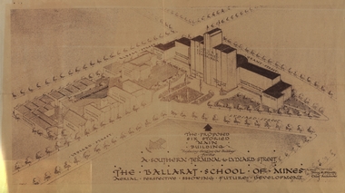
Plan - Architectural Drawing, Ballarat School of Mines: The Proposed Six Storied Main Building, 5 December 1947
... Mines site showing the proposed six storied Main Building to replace the existing historical gaol building. This was never built. This was sent to Jack Barker in 1970 by Jim Docherty. He was a member of the Board of Technical School Inspectors, Education Department ballarat school of mines historic buildings percy everett architect architectural drawing jack barker jim docherty education department Drawing of the propose six storied main building for the School of Mines site, Ballarat. ...Drawing of the School of Mines site showing the proposed six storied Main Building to replace the existing historical gaol building. This was never built. This was sent to Jack Barker in 1970 by Jim Docherty. He was a member of the Board of Technical School Inspectors, Education DepartmentDrawing of the propose six storied main building for the School of Mines site, Ballarat.ballarat school of mines, historic buildings, percy everett, architect, architectural drawing, jack barker, jim docherty, education department -
Federation University Historical Collection
Book - Book - Scrapbook, Ballarat School of MInes: Scrapbook of Newspaper Cuttings, Book 79. June 1997 to August 1997
... The papers concerned are The Courier, Ballarat, The Australian, The Age and other region papers over the period of 7 June 1997 to 5 August 1997. teaching positions advertised pre-employment courses courses available enrolment for smb courses nathan holliday nrma top apprentice scott brady ballarat's gallows mystery solved federal tafe plan worries smb head memorial plaque to hanged men freighter's engineering traineeship tafe merger creates super-college smb agrees to merger wimmera tafe rejects merger new evidence points to remains' location peter bailey to compete in youth skills olympics switzerland merger official course on providing a home away from home roy schrieke retires descendant against memorial peter bailey gold medallist skill olympics in st gallen excellent results for ballarat region aquaculture course historic sites listed henry sutton reverse tafe decision stawell times-news more host families needed david belford award winner city yearning for cultural heart corporate learning gold medal for peter bailey competition on apprentice funding'play revisits our history town and gown debate viticulture traineeship program one tafe division career in food row looms over staff offers jeff kennet cuts new attitude to education victorian primary industries board apprenticeships rural studies department Book with yellow cover, front, spiral bound. Ballarat School of MInes ...Collection of newspaper articles related to Ballarat School Of Mines.They cover activities and advertisements for staff. The papers concerned are The Courier, Ballarat, The Australian, The Age and other region papers over the period of 7 June 1997 to 5 August 1997. Book with yellow cover, front, spiral bound. teaching positions advertised, pre-employment courses, courses available, enrolment for smb courses, nathan holliday, nrma top apprentice, scott brady, ballarat's gallows mystery solved, federal tafe plan worries smb head, memorial plaque to hanged men, freighter's engineering traineeship, tafe merger creates super-college, smb agrees to merger, wimmera tafe rejects merger, new evidence points to remains' location, peter bailey to compete in youth skills olympics, switzerland, merger official, course on providing a home away from home, roy schrieke retires, descendant against memorial, peter bailey gold medallist, skill olympics in st gallen, excellent results for ballarat region, aquaculture course, historic sites listed, henry sutton, reverse tafe decision, stawell times-news, more host families needed, david belford award winner, city yearning for cultural heart, corporate learning, gold medal for peter bailey, competition on apprentice funding'play revisits our history, town and gown debate, viticulture traineeship program, one tafe division, career in food, row looms over staff offers, jeff kennet cuts, new attitude to education, victorian primary industries board apprenticeships, rural studies department -
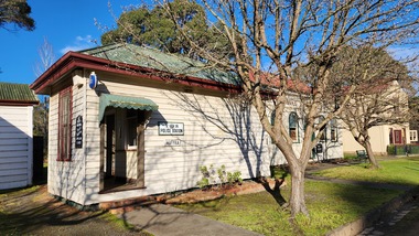
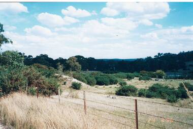
 Bendigo Historical Society Inc.
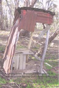
Photograph - DIAMOND HILL HISTORIC RESERVE - OLD TOILET
... History House 11 Mackenzie Street Bendigo goldfields BENDIGO Mining Spring Gully Reservoir reserve Colour photo of old corrugated iron toilet, taken near mine site in Spring Gully Reservoir Reserve ( Diamond Hill) Image shows wooden toilet frame, no sides left on toilet building and a lean of approx 10 degrees on the structure. Photograph DIAMOND HILL HISTORIC ...Colour photo of old corrugated iron toilet, taken near mine site in Spring Gully Reservoir Reserve ( Diamond Hill) Image shows wooden toilet frame, no sides left on toilet building and a lean of approx 10 degrees on the structure.bendigo, mining, spring gully reservoir reserve -
 The Beechworth Burke Museum
Photograph, 1960s
... site of the Rocky Mountain Mining Company workings and was officially opened by Minister for Lands, Mr Baily, on October 5, 1928. The disused and unattractive remains of the mine were converted into a recreational area intended for swimming, boating, and fishing. The lake is named after Mr L.H. Sambell, shire engineer and secretary of the Forward Beechworth Committee, who advocated for the enhancement of Beechworth into a tourist destination and was central to the planning and establishment of the lake. This photograph is of historic ...This photograph was taken in the 1960s at Lake Sambell Caravan Park, visible in the photograph are individual caravan sites with electricity outlets, a large single-story building, a parked car, and two caravans partially obstructed by trees. Lake Sambell Caravan Park opened in 1959 owing to the work of R.E. Carter, Beechworth Shire engineer from 1954-63. Carter advocated for improvements to the lake and surrounding area in order to encourage tourism in Beechworth. The opening of the caravan park was part of many improvements to Lake Sambell made in this period by Carter including: the swimming pool in 1961, water skiing and boating facilities, and increased lake surface in 1964. These improvements were financed mainly by grants from the Tourist Development Authority. The popularity of caravanning in Australia exploded during this post-war period of the late 1950s and 1960s. This popularity was driven by multiple factors, including: the stopping of fuel rations, the accessibility of car ownership through the manufacturing of affordable cars, technological developments in caravan design, and the increase in prosperity and leisure time for many Australians. Facilities such as electrical outlets to power caravans are present in this photograph of Lake Sambell Caravan Park. Lake Sambell is an artificial lake that was developed on the previous site of the Rocky Mountain Mining Company workings and was officially opened by Minister for Lands, Mr Baily, on October 5, 1928. The disused and unattractive remains of the mine were converted into a recreational area intended for swimming, boating, and fishing. The lake is named after Mr L.H. Sambell, shire engineer and secretary of the Forward Beechworth Committee, who advocated for the enhancement of Beechworth into a tourist destination and was central to the planning and establishment of the lake. This photograph is of historic and social significance in documenting the enhancement of the Lake Sambell area overseen by R.E. Carter and providing insight into caravanning during the 1960s in Australia. Caravanning was extremely popular in Australia during the late 1950s and 60s due to multiple social and economic factors including the stopping of fuel rations, the accessibility of car ownership through the manufacturing of affordable cars, technological developments in caravan design, and the increase in prosperity and leisure time for many Australians. Black and white rectangle photograph printed on photographic paper and unmounted.Reverse: 3538/ [logo back printing KODAK/ VELOX/ PAPER] / C798lake sambell caravan park, lake sambell, lake sambell 1960s, lake sambell fishing, lake sambell boating, lake sambell swimming pool, r.e. carter, l.h. sambell, tourist development authority, caravanning 1960s, caravan electricity outlets, caravan park, forward beechworth committee, rocky mountain mining company, lake caravan park, caravan mid 20th century, beechworth tourism, travel in the 1960s, holiday 1960s -
 The Beechworth Burke Museum
Photograph, 1920-1950
... mine. After Pund's death in 1915, GSG Amalgamated Co operated the site, continuing sluicing until 1950. This image of hydraulic sluicing methods shows the extent of water-works engineering in the landscape. This photograph has historic ...This image taken between 1920-1930 depicts open-cut hydraulic sluicing at the Three Mile Mine, located about five kilometres south of Beechworth. Alluvial, or surface, mining began on this site in the 1850s, but was soon replaced by hydraulic sluicing methods. By the start of 1880 it is estimated that nine hundred miles of water races had been cut though soil and rock in the Beechworth district. Hydraulic sluicing employs high pressure jets of water to blast away large areas of earth and wash it down to be run through a sluice box. Gold gets caught in the sluice and the remaining slurry is washed away. Large water quantities were required for hydraulic sluicing, and the long water races and deep tailraces that were constructed were considered great engineering feats. This method of mining is extremely effective, but causes significant environmental damage and impacts to waterways and agricultural operations. Miners at Beechworth built extensive networks of races and dams to secure reliable supplies of water on a scale far greater than elsewhere in Victoria. By the 1880s Beechworth's water barons continued to hold more than half of all the water right licences on issue and undertook sluicing operations on a massive scale. The manipulation of surface and ground water via race networks was well planned and recorded in detail by local mining surveyors. The maps that were created, combined with modern geo-spatial technologies, provide a vital key in understanding the great lengths to which miners went to capture and control critical water resources. Today, Three Mile mine is called Baarmutha. The Three Mile Mine was unproductive until 1865 when John Pund and three other miners secured a fifteen year license and constructed a water race from Upper Nine Mile Creek to Three Mile Creek. In the early twentieth century Pund & Co. averaged over one thousand ounces of gold per year from the mine. After Pund's death in 1915, GSG Amalgamated Co operated the site, continuing sluicing until 1950. This image of hydraulic sluicing methods shows the extent of water-works engineering in the landscape. This photograph has historic and research potential for understanding changes to the landscape, the evolution of mining methods, and the extensive construction, manipulation and management of water networks in the Beechworth district. Black and white rectangular photograph on matte paperReverse: 7597-1 / Sluice Mining / Copied from original on loan from Webb (Qld) / Donated Nov 2009 / Baarmutha Three Mile Mine c1920-1950 / Managed by the Plain Bros then Parkinsons / Current Location is: Beechworth Animal Shelter / used for Baarmuthaburke museum, beechworth museum, beechworth, gold fields, gold rush, victorian gold rush, hydraulic sluicing, spring creek, netwown falls, mining tunnels, water races, tailraces, gold ming history, colonial australia, australian gold rushes, mining technology, beechworth historic district, indigo gold trail, indigo shire, john pund, water manipulation, water engineering, three mile creek, three mile mine, water race, large-scale mining methods, historical mining construction, alluvial mining, mining environmental impacts, baarmutha, water barons -
 Eltham District Historical Society Inc
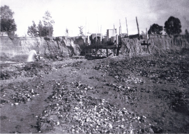
Folder, Victorian Goldfields Project: Historic gold mining sites in St Andrews mining division, 1999
... Photocopy of map headed: Location of mines and reefs from Geological survey of Victoria, Yan Yean with the Diamond Creek prominant on the map. no date caledonian gold fields, caledonina gold field, david bannear, gold mining, harry gilham collection, queenstown, st andrews, warrandyte goldfield 35 page report with map and print out of cover letter (email form) from donor Victorian Goldfields Project: Historic gold mining sites in St Andrews mining division Folder ...Heritage site report and gazetteer by David Bannear, head consultant for archealogy for the Department of Natural Resources and Environment. Includes information on the Warrandyte Goldfield and the Caledonia Goldfield, Queenstown (now known as St Andrews), One Tree Hill, Kingston (now known as Panton Hill), Kangaroo Grounds, You You Hill, Kingstown, South Morang, Nillumbik, (now known as Diamond Creek), Steele's Creek, Yarrambet and Kinglake. Photocopy of map headed: Location of mines and reefs from Geological survey of Victoria, Yan Yean with the Diamond Creek prominant on the map. no date35 page report with map and print out of cover letter (email form) from donorcaledonian gold fields, caledonina gold field, david bannear, gold mining, harry gilham collection, queenstown, st andrews, warrandyte goldfield -
 Eltham District Historical Society Inc
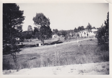
Photograph, Queenstown - St. Andrews District. "Quartz awaiting crushing at the State Battery in Smith's Gully.", c.1929
... mines and was a sizeable weatherboard building enclosing the engine and stampers. All that now remains are the bases for the machinery that comprised the battery, one timber and a couple of concrete bases and the nearby dam, which supplied water. However the historic significance of the site...mines and was a sizeable weatherboard building enclosing the engine and stampers. All that now remains are the bases for the machinery that comprised the battery, one timber and a couple of concrete bases and the nearby dam, which supplied water. However the historic significance of the site ..."The State Battery was the central component in the gold mining of this area from the 1920s. The battery crushed the gold bearing quartz extracted from the mines and was a sizeable weatherboard building enclosing the engine and stampers. All that now remains are the bases for the machinery that comprised the battery, one timber and a couple of concrete bases and the nearby dam, which supplied water. However the historic significance of the site remains and is enhanced by the Queenstown Cemetery on the other side of Smiths Gully Road". - Bick Study 1922 This site is now the Peter Franke Reserve and is managed by Parks Victoria Photo Source: The Leader, Nov. 2nd, 1929This photo forms part of a collection of photographs gathered by the Shire of Eltham for their centenary project book,"Pioneers and Painters: 100 years of the Shire of Eltham" by Alan Marshall (1971). The collection of over 500 images is held in partnership between Eltham District Historical Society and Yarra Plenty Regional Library (Eltham Library) and is now formally known as the 'The Shire of Eltham Pioneers Photograph Collection.' It is significant in being the first community sourced collection representing the places and people of the Shire's first one hundred years.Digital imagesepp, shire of eltham pioneers photograph collection, queenstown, st andrews, gold mining, smiths gully -
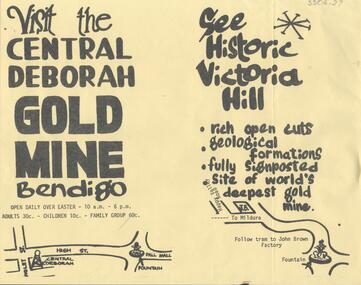 Bendigo Historical Society Inc.
Document - CENTRAL DEBORAH GOLD MINE: ADVERTISING FLYER
... 'Visit the Central Deborah Gold Mine Bendigo' 'See Historic Victoria Hill'. Handrawn mud maps for each site on bottom of page....'Visit the Central Deborah Gold Mine Bendigo' 'See Historic Victoria Hill'. Handrawn mud maps for each site on bottom of page. ...BHS CollectionA4 advertising flyer,yellow background, black text. 'Visit the Central Deborah Gold Mine Bendigo' 'See Historic Victoria Hill'. Handrawn mud maps for each site on bottom of page.bendigo, mining, crentral deborah gold mine -
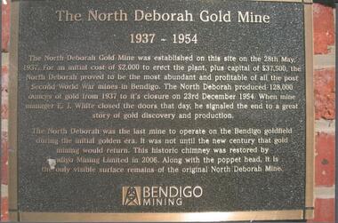 Bendigo Historical Society Inc.
Photograph - NORTH DEBORAH GOLD MINE BENDIGO MINING PLAQUE
... mine to operate on the Bendigo goldfield during the initial golden era. It was not until the new century that gold mining would return. This historic chimney was restored by Bendigo Mining Limited in 2006. Along with the poppet head. It is the only visible surface remains of the original North Deborah Mine.' The mine site...mine to operate on the Bendigo goldfield during the initial golden era. It was not until the new century that gold mining would return. This historic chimney was restored by Bendigo Mining Limited in 2006. Along with the poppet head. It is the only visible surface remains of the original North Deborah Mine.' The mine site ...Metal plaque, gold writing, erected at the site of the former North Deborah Gold Mine when the brick chimney was restored by Bendigo Mining NL. The plaque reads: 'The North Deborah Gold Mine, 1937-1954. The North Deborah Gold mine was established on this site on the 28th May 1937. For an initial cost of 2,000 pounds to erect the plant, plus capital of 37,500 pounds, the North Debnorah proved to be the most abundant and profitable of all the post Second War mines in Bendigo. The North Deborah produced 128,000 ounces of gold from 1937 to its closure on 23rd December 1954. When mine manager E.J. White closed the doors that day he signaled the end to a great story of gold discovery and production. The North Deborah was the last mine to operate on the Bendigo goldfield during the initial golden era. It was not until the new century that gold mining would return. This historic chimney was restored by Bendigo Mining Limited in 2006. Along with the poppet head. It is the only visible surface remains of the original North Deborah Mine.' The mine site is situated off Breen Street in Golden Square.Kay MacGregor 2012bendigo, mining, north deborah mining company -
 Bendigo Historical Society Inc.
Map - BENDIGO HISTORICAL SOCIETY COLLECTION: EAGLEHAWK MINE MAP
... Map has letter attached from the Department of Conservation, Forests and Lands, 22 March, 1990, addressed to Felicity Kingerlie, BHS, requesting information regarding the historic mining sites marked on the map. Sites marked are: A. Golden Age Mine, engine mountings present B. ...mines Base map Australian map grid of Eaglehawk area. Map has letter attached from the Department of Conservation, Forests and Lands, 22 March, 1990, addressed to Felicity Kingerlie, BHS, requesting information regarding the historic mining sites marked on the map. ...Base map Australian map grid of Eaglehawk area. Map has letter attached from the Department of Conservation, Forests and Lands, 22 March, 1990, addressed to Felicity Kingerlie, BHS, requesting information regarding the historic mining sites marked on the map. Sites marked are: A. Golden Age Mine, engine mountings present B. Johnson's No. 2 Mine, engine mountings, old boiler foundations C. Johnson's No. 1 Mine, mullock retaining wall made from sandstone, engine mountings, remains of old building demolished? D. Toma's Eucalyptus Factory, old boiler still there, boiler shed, chimney (remnants of) outlet drain, distilling vats, dam, remnant of winch. E. New Argus Mine,mullock heap F. New Moon Mines Dams (1) stone walls G. North Lightning Hill Mine, engine mountings, quartz retainer wall, Pascoe and Simmons open cuts and other open cuts here too H. New Prince of Wales Mine and Poppet Head I. Quarry site for stone, excavation (for miners cottages in Clarke Street) J. Lancashire open cut mine K. Virginia Hill (cynaide vats etc) L. South Prince of Wales mine, now capped and fenced M (possibly ) Catherine United Mine, engine mountings, battery mountings?bendigo, mining, eaglehawk mines -
Federation University Historical Collection
Book, Historic Sites Survey: North Central Study Area, 1979, 1979
... Barker Library (top floor) Mount Helen goldfields The North Central Study Area included the Shires of Avoca, Bet Bet, east Loddon, Goulburn, Untly, Kara Kara, Korong, Maldon, Marong, Metcalfe, McIvor, Newstead, Strathfieldsaye, Stawell, Talbot, Clunes, Tullaroop and Waranga. castlemaine mount alexander goldfield maldon percydale warrenmang moliagul tarnagulla stuart mill the whipstick whroo rushworth graytown ironbark forest st arnoaud new bendigo landsborough inglewood kurting wedderburn wehla kooroora langham flat mcintyre rheola diamond hill fosterville coliban water works green gully newstead muckleford forest costerfield graytown bailieston waranga irrigaiton system eucalyptus distillery mia mia bridge korokubeal township researce concegella slate quarry chewton fryerstown kingower timor talbot majorca carisbroook clunes st arnaud taradale icomos dunolly limestone castlemaine slate quarry harcourt granite taradale railway viaduct loddon united waterworks trust gouldburn weir carisbrook lock-up history of tree planting in streets history of public reserves r.u. nicholls nurseryman thomas lang francis moss ballarat botanical gardens ballarat school of mines botanical gardens lake wendouree victoria park, ballarat muont holled smith ballaarat old cemetery planting eastern oval ballarat east botanical gardens ballarat east town hall gardens eureka stockade reserve ballarat observatory plantings yarrowee creek plantings yarrowee bluestone channels ballarat woollen mill band and albion mullock heap black hill plantings yarrowee creek channels canadian creek channel specimen vale channel poverty point reserve union jack reserve buninyong imperial mine, buninyong victoria street plantings bridge mall sturt street gardens ballarat avenue of honour plantings white flat oval plantings camp street elms burnt creek 153 page book with white plastic binding. It is an historic sites ...The North Central Study Area included the Shires of Avoca, Bet Bet, east Loddon, Goulburn, Untly, Kara Kara, Korong, Maldon, Marong, Metcalfe, McIvor, Newstead, Strathfieldsaye, Stawell, Talbot, Clunes, Tullaroop and Waranga. 153 page book with white plastic binding. It is an historic sites survey for the North Central Study Area commissioned by the Land Conservation Council, the Ministry for COnservation and the Australian Heritage Commission. castlemaine, mount alexander goldfield, maldon, percydale, warrenmang, moliagul, tarnagulla, stuart mill, the whipstick, whroo, rushworth, graytown ironbark forest, st arnoaud, new bendigo, landsborough, inglewood, kurting, wedderburn, wehla, kooroora, langham flat, mcintyre, rheola, diamond hill, fosterville, coliban water works, green gully, newstead, muckleford forest, costerfield, graytown, bailieston, waranga irrigaiton system, eucalyptus distillery, mia mia bridge, korokubeal township researce, concegella slate quarry, chewton, fryerstown, kingower, timor, talbot, majorca, carisbroook, clunes, st arnaud, taradale, icomos, dunolly, limestone, castlemaine slate quarry, harcourt granite, taradale railway viaduct, loddon united waterworks trust, gouldburn weir, carisbrook lock-up, history of tree planting in streets, history of public reserves, r.u. nicholls nurseryman, thomas lang, francis moss, ballarat botanical gardens, ballarat school of mines botanical gardens, lake wendouree, victoria park, ballarat, muont holled smith, ballaarat old cemetery planting, eastern oval, ballarat east botanical gardens, ballarat east town hall gardens, eureka stockade reserve, ballarat observatory plantings, yarrowee creek plantings, yarrowee bluestone channels, ballarat woollen mill, band and albion mullock heap, black hill plantings, yarrowee creek channels, canadian creek channel, specimen vale channel, poverty point reserve, union jack reserve buninyong, imperial mine, buninyong, victoria street plantings, bridge mall, sturt street gardens, ballarat avenue of honour plantings, white flat oval plantings, camp street, elms, burnt creek -
 Federation University Historical Collection
Document - Documents, Golden Point - Mount Pleasant Progress Association Establishment
... Topics include: Pearce's Park; removal of elms, names and addresses of members, Sovereign Hill realignment; Sovereign Hill Lookout; membership form; Golden Point Historic Mines Direction Indicator; Ballarat Observatory; Nerrina Tip; Yarrowee Creek; Mine Capping (Sovereign Mine); tree planting (Sovereign Hill Lookout); Magpie Street Park; Hill Street; Yarrowee Flora Park; Barkly Street; South Street Bluestone Gutter; Ballarat Goldfields; Eastern baths site; Grant Street; Flooding; Aboriginal Advancement League; Sunnyside Woollen Mill; Chinese Garden; Golden Point Primary School closure; Ballarat West Goldfields; Sovereign Hill Land Title and Management Revision; Wainwright; Street; Llanberris; Yuille's Station Park...Topics include: Pearce's Park; removal of elms, names and addresses of members, Sovereign Hill realignment; Sovereign Hill Lookout; membership form; Golden Point Historic Mines Direction Indicator; Ballarat Observatory; Nerrina Tip; Yarrowee Creek; Mine Capping (Sovereign Mine); tree planting (Sovereign Hill Lookout); Magpie Street Park; Hill Street; Yarrowee Flora Park; Barkly Street; South Street Bluestone Gutter; Ballarat Goldfields; Eastern baths site; Grant Street; Flooding; Aboriginal Advancement League; Sunnyside Woollen Mill; Chinese Garden; Golden Point Primary School closure; Ballarat West Goldfields; Sovereign Hill Land Title and Management Revision; Wainwright; Street; Llanberris; Yuille's Station Park Golden Point - Mount Pleasant Progress Association Establishment Document Documents ...The Golden Point - Mt Pleasant Progress Association was established on Wednesday 6 April 1983. Membership was open to any person or organisation in the area generally bounded by Bridge mall and Skipton Street, Elsworth Street and main Road. annual family or organisation membership was $2.00. Mara Gluyas served as secretary of the Golden Point - Mt Pleasant Progress Association from 1983 to 1994. Ian McKinnon was the President from 1983 to 1992. Kerry Daniels was the President in 1994.A small white cardboard box with purple lid of A4 documents relating to the establishment of the Golden Point - Mt Pleasant Progress Association. The documents include the original constitution and minutes. Topics include: Pearce's Park; removal of elms, names and addresses of members, Sovereign Hill realignment; Sovereign Hill Lookout; membership form; Golden Point Historic Mines Direction Indicator; Ballarat Observatory; Nerrina Tip; Yarrowee Creek; Mine Capping (Sovereign Mine); tree planting (Sovereign Hill Lookout); Magpie Street Park; Hill Street; Yarrowee Flora Park; Barkly Street; South Street Bluestone Gutter; Ballarat Goldfields; Eastern baths site; Grant Street; Flooding; Aboriginal Advancement League; Sunnyside Woollen Mill; Chinese Garden; Golden Point Primary School closure; Ballarat West Goldfields; Sovereign Hill Land Title and Management Revision; Wainwright; Street; Llanberris; Yuille's Station Parkgolden point, mount pleasant, mt pleasant, ian mckinnno, mara gluyas, peter hiscock, frank williams, geoff howard, leigh gillett, sovereign hill, kerry daniels, norm strange; graeme kent; george netherway; keith rash; ian mckinnon, albert graham, bryan crebbin, jim humphreys. wid radbourn, heath martin, janet dore, alex mills park -
 Old Gippstown
Building - Police Station
... site in Maffra, by the new police residence office. The office was enlarged in 1936, incorporating the old police station. High local historic significance on account of age. police maffra Old Gippstown West Gippsland Gippsland Gippsland Heritage Park Goldfields Coal Mine Victorian era Moe Historical Village Wellington shire Old Gippstown Heritage Park Latrobe Valley Law Latrobe City Council A small timber building, rectangular in shape with a gabled corrugated iron roof. ...One-room police station was built in 1869 in Maffra and moved c.1882 to a new site in Maffra, by the new police residence office. The office was enlarged in 1936, incorporating the old police station.High local historic significance on account of age.A small timber building, rectangular in shape with a gabled corrugated iron roof. There is a small hood over the rear entrance of the station.police, maffra, old gippstown, west gippsland, gippsland, gippsland heritage park, goldfields, coal mine, victorian era, moe, historical village, wellington shire, old gippstown heritage park, latrobe valley, law, latrobe city council -
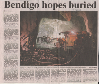 Bendigo Historical Society Inc.
Newspaper - Kangaroo Flat Gold Mine Collection: Bendigo N.L. Mine Closure, Bendigo Advertiser, 9.1. 2007, 10.1.2007
... mine site was planned to shut down over a period of six months, during which time 150 jobs were expected to be lost. Almost 60 per cent was wiped off the Company's value on January 9th 2007 trading. Bendigo Mining N.L. Bendigo mining gold Douglas Buerger Managing Director Julie Rivendell mine closure share market stock market Two newspaper articles: 1. 'Bendigo hopes buried', one page article. Image of mining equipment underground in stope. Text underneath image: Poor ore grades from Bendigo's operations, have forced it to concede that its interpretation of historic ...Production at the Bendigo Mining N.L. Kangaroo Flat mine site was planned to shut down over a period of six months, during which time 150 jobs were expected to be lost. Almost 60 per cent was wiped off the Company's value on January 9th 2007 trading. Two newspaper articles: 1. 'Bendigo hopes buried', one page article. Image of mining equipment underground in stope. Text underneath image: Poor ore grades from Bendigo's operations, have forced it to concede that its interpretation of historic mining data has been 'optimistic'. Bendigo Advertiser article 9.1.2007 2. On front of page 'Community Upbeat' and 'Many more challenges to overcome' on one page. Cr. Julie Rivendell comments on closure. Bendigo Advertiser article 10.1.2007. On back of page: Investor's worst fears realised'.bendigo mining n.l., bendigo, mining, gold, douglas buerger, managing director, julie rivendell, mine closure, share market, stock market -
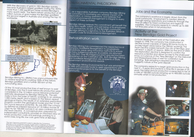 Bendigo Historical Society Inc.
Flyer - Kangaroo Flat Gold Mine Collection: New Bendigo Gold Project, Unknown
... site in Kangaroo Flat, in 1998. A decline tunnel was constructed and designed to reach a depth of 800 m below the surface, passing underneath historic workings. The information brochure was produced to provide information to Bendigo community members. Bendigo Mining N.L. Bendigo mining gold Kangaroo Flat environmental study Colour trifold information brochure (2 copies). On front: 'New Bendigo Gold Project, Bendigo Mining N.L'. Brochure details background of project, environmental philosophy, rehabilitation work, jobs in the economy and current activity on the New Bendigo Gold Project. Flyer Kangaroo Flat Gold Mine ...The New Bendigo Gold Project began surface workings at the Carshalton site in Kangaroo Flat, in 1998. A decline tunnel was constructed and designed to reach a depth of 800 m below the surface, passing underneath historic workings. The information brochure was produced to provide information to Bendigo community members.Colour trifold information brochure (2 copies). On front: 'New Bendigo Gold Project, Bendigo Mining N.L'. Brochure details background of project, environmental philosophy, rehabilitation work, jobs in the economy and current activity on the New Bendigo Gold Project. bendigo mining n.l., bendigo, mining, gold, kangaroo flat, environmental study -
 Bendigo Historical Society Inc.
Document - Kangaroo Flat Gold Mine Collection: Diamond Hill Historic Area, Department of Conservation and Environment, April 1991
... On the back of the sheet: map of the Diamond Hill historic area, showing location of former mining sites. Document Kangaroo Flat Gold Mine Collection: Diamond Hill Historic Area Department of Conservation and Environment ...Diamond Hill was a gold mining village 5 km south of Bendigo and about 1 km west of the Spring Gully Reservoir. Its location is now inaccessible and within the water catchment area. Diamond Hill was reputedly named after a diamond shaped rock on the hill. With the development of mining companies which employed workers with families, a school was needed by 1873 and one was opened at the beginning of the next year. The mining companies included Great Comet Quartz Mining, Golden Fleece Quartz Mining, Albert Tribute, Glasgow Golconda, and Albert Gold Mining and Crushing. Mining continued beyond 1900, as recorded in the Australian handbook, 1903. The Bendigo Mining N.L. company was located nearby, adjoining Ham Street. One page double sided information sheet, produced by Department of Conservation and Environment, April 1991, detailing the mining history of the Diamond Hill area, Kangaroo Flat/Spring Gully area. On the back of the sheet: map of the Diamond Hill historic area, showing location of former mining sites. bendigo mining n.l., bendigo, mining, gold, city of greater bendigo, great comet quartz mining, golden fleece quartz mining, albert tribute, glasgow golconda, albert gold mining and crushing, golden gully, dead dog gully, german miners, british new chum, south golden carshalton, hansel mundy, morning light, mullock tailings, stamp battery, -
Marysville & District Historical Society
Document (item) - Historic Site Register Sheet, Parks Victoria, Historic Site Recording System-Site Register Sheet-Chester & Locke Mine, 1989
... Historic Site Recording System-Site Register Sheet-Chester & Locke Mine...A copy of a historic site register sheet for the Chester and Locke gold mine near Marysville in Victoria....A copy of a historic site register sheet for the Chester and Locke gold mine near Marysville in Victoria....Historic Site Recording System-Site Register Sheet-Chester & Locke Mine Document Historic Site Register Sheet Parks Victoria ...A copy of a historic site register sheet for the Chester and Locke gold mine near Marysville in Victoria.A copy of a historic site register sheet for the Chester and Locke gold mine near Marysville in Victoria. The Golden Bower gold mine was a quartz reef mine. William Edward Chester discovered the Golden Secret gold vein which became part of the Golden Bower Mine at Chesterville near Donovans Creek on the Cumberland goldfield which he mined with George Locke until the late 1930s. chester and locke mine, william chester, george locke, cambarville, yarra ranges, walker's hotel, marysville, victoria -
 Buninyong & District Historical Society
Photograph - Original Photograph, Site of Mine holes and mullock heap, Green Hill Diggings, Sandy's Hill Rd., Durham Lead, 20/03/1996
... Buninyong & District Historical Society Old Court House, Buninyong Town Hall 313 Learmonth Street Buninyong goldfields historic, mining Mining Green Hills Sandy's Hill Rd. Durham Lead Colour photo, Site of Mine holes and mullock heap, Green Hill Diggings, Sandy's Hill Rd., Durham Lead, Site of Mine holes and mullock heap, Green Hill Diggings, Sandy's Hill Rd., Durham Lead Photograph Original Photograph Anne Beggs Sunter ...historic, miningColour photo, Site of Mine holes and mullock heap, Green Hill Diggings, Sandy's Hill Rd., Durham Lead, mining, green hills, sandy's hill rd., durham lead -
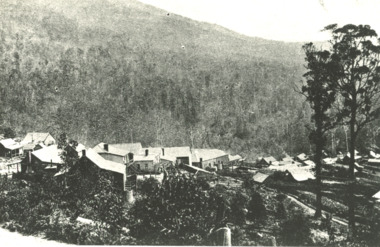 Lakes Entrance Historical Society
Photograph - Sunnyside, Mt Wills, Omeo Victoria c1907
... Lakes Entrance Historical Society 4 Marine Parade Lakes Entrance gippsland Historic Sites Mines and Mining Black and white photograph of the township of Sunnyside which came into existence after gold was discovered at Mt Wills north of Omeo Victoria Photograph Sunnyside, Mt Wills, Omeo Victoria c1907 ...Black and white photograph of the township of Sunnyside which came into existence after gold was discovered at Mt Wills north of Omeo Victoriahistoric sites, mines and mining -
Lakes Entrance Historical Society
Book, Drew G J, Discovering Historic Burra, 1998
... Lakes Entrance Historical Society 4 Marine Parade Lakes Entrance gippsland Historic Sites Township Mines and Mining A description of the historic copper mining area of Burra, South Australia with maps tourist trail photographs. ...A description of the historic copper mining area of Burra, South Australia with maps tourist trail photographs.historic sites, township, mines and mining -
Clunes Museum
Document - POST OFFICE HISTORIC RECORD
... 2 COPIES OF HISTORIC RECORD OF CLUNES POST OFFICE, WHICH WAS OPENED IN OCTOBER 1857, CLUNES WAS A MAJOR GOLD-MINIG SETTLEMENT AND WAS THE SITE OF THE DISCOVERY OF GOLD IN 1851 . IN 1857 IT HAD A POPULATION OF 22O, IN 1861 THERE WERE 1711 IN 1881 5811 IN 1891 3486 IN 1901 2426 LONG YIELDING QUARTZ MINES WERE LOCATED AT CLUNES. ...Clunes Museum 36 Fraser Street enter building through Collins Place Clunes goldfields CLUNES POST OFFICE POST OFFICERS 1857 TO 1975 HISTORY OF POST OFFICE 2 COPIES OF HISTORIC RECORD OF CLUNES POST OFFICE, WHICH WAS OPENED IN OCTOBER 1857, CLUNES WAS A MAJOR GOLD-MINIG SETTLEMENT AND WAS THE SITE OF THE DISCOVERY OF GOLD IN 1851 . IN 1857 IT HAD A POPULATION OF 22O, IN 1861 THERE WERE 1711 IN 1881 5811 IN 1891 3486 IN 1901 2426 LONG YIELDING QUARTZ MINES WERE LOCATED AT CLUNES. ...2 COPIES OF HISTORIC RECORD OF CLUNES POST OFFICE, WHICH WAS OPENED IN OCTOBER 1857, CLUNES WAS A MAJOR GOLD-MINIG SETTLEMENT AND WAS THE SITE OF THE DISCOVERY OF GOLD IN 1851 . IN 1857 IT HAD A POPULATION OF 22O, IN 1861 THERE WERE 1711 IN 1881 5811 IN 1891 3486 IN 1901 2426 LONG YIELDING QUARTZ MINES WERE LOCATED AT CLUNES. THE TOWN IS LOCATED ABOUT 33 KM NORTH OF BALLARAT. IT BECAME AN LPO ON 4 JANUARY 1994 BARRED NUMERAL CANCEL 147 WAS USED AT CLUNES. IT IS RATED AS COMMON POST OFFICERS AT CLUNES HAVE BEEN: MARK PATTINSON 1857-1861 JAMES LYNDONCOLLIER 1861-1884 JOHN HARTLEY KIBBLE 1884-1886 SAMUAL BAKER 1886-1887 AUGUSTUS WOLFE 1887-1890 MATTHEW GLENTON 1891-1903 JAMES DIRLING HUDSON 1903-1912 WALTER CHARLES THORNTON 1912-1918 FRANK EDGAR JOHN BLAKE 1918-1923 HERBERT STANLEY OPPERMAN 1923-1925 WILLIAM HENRY MADDOCK 1925-1928 GEORGE LEONARD POWELL 1928-1929 GEORGE A;EXANDER CAMERON 1929-1934 G A STEVENS (STEPHENS?) 1934-1945 WALTER BERTRAND WILLIAMSON 1945-1950 FEDERA; HENRY GORDEN RODDA 1950-1952 PATRICK JOSEPH LYNCH 1952-1956 THOMAS SELWYN BALLINGER 1956-1962 JOHN PATRICK GRIGG 1962-1966 LESLIE BENJAMIN CARMICHAEL 1966-1975 G M STOUT 1975 TO THERE IS A PHOTOGRAPH OF THE POSTOFFICE AND SOME STAMPS. ONE COPY IS LAMINATEDclunes post office, post officers 1857 to 1975, history of post office -
 Ballarat Heritage Services
Photograph - Colour, Dorothy Wickham, St Just, Cronwall, World Heritage Site
... Geevor, one of the last mines to close in Cornwall (1990), was saved from demolition and is now the largest metalliferous mine site open to the public in the UK. The historic mining town of St Just is home to characteristic rows of granite mine workers’ cottages, public squares, shops, cafés, art galleries and, just off Bank Square, a medieval grassed amphitheatre – the Plen an Gwary or ‘playing place’....Geevor, one of the last mines to close in Cornwall (1990), was saved from demolition and is now the largest metalliferous mine site open to the public in the UK. The historic mining town of St Just is home to characteristic rows of granite mine workers’ cottages, public squares, shops, cafés, art galleries and, just off Bank Square, a medieval grassed amphitheatre – the Plen an Gwary or ‘playing place’. st just, world heritage, ellis, penrose, cornwall, mining, mines St Just, Cronwall, World Heritage Site Photograph - Colour Dorothy Wickham ...A stone’s throw from Land’s End, this is the most westerly Area of the Site. St Just is characterised by big skies, jagged rocks, stark moorland, and iconic clifftop engine houses perched above the Atlantic in some incredible locations. No wonder this dramatic setting has inspired generations of artists, writers and photographers. World-famous for their mineralogy, the mining sites here are extremely well preserved – as is the sense of community amongst the people whose lives they once dominated. This Area’s unique geography and mineralogy meant that undersea mining was more concentrated here than anywhere else in the world in the 18th and 19th centuries. The oldest surviving Cornish beam engine (constructed in 1840) remains in its original engine house at Levant, restored and still working under steam. Geevor, one of the last mines to close in Cornwall (1990), was saved from demolition and is now the largest metalliferous mine site open to the public in the UK. The historic mining town of St Just is home to characteristic rows of granite mine workers’ cottages, public squares, shops, cafés, art galleries and, just off Bank Square, a medieval grassed amphitheatre – the Plen an Gwary or ‘playing place’.st just, world heritage, ellis, penrose, cornwall, mining, mines -
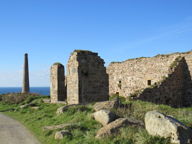 Ballarat Heritage Services
Photograph - Colour, Dorothy Wickham, St Just, Cornwall, World Heritage Site
... Geevor, one of the last mines to close in Cornwall (1990), was saved from demolition and is now the largest metalliferous mine site open to the public in the UK. The historic mining town of St Just is home to characteristic rows of granite mine workers’ cottages, public squares, shops, cafés, art galleries and, just off Bank Square, a medieval grassed amphitheatre – the Plen an Gwary or ‘playing place’....Geevor, one of the last mines to close in Cornwall (1990), was saved from demolition and is now the largest metalliferous mine site open to the public in the UK. The historic mining town of St Just is home to characteristic rows of granite mine workers’ cottages, public squares, shops, cafés, art galleries and, just off Bank Square, a medieval grassed amphitheatre – the Plen an Gwary or ‘playing place’. st just world heritage, ellis, penrose cornwall mining mines St Just, Cornwall, World Heritage Site Photograph - Colour Dorothy Wickham ...A stone’s throw from Land’s End, this is the most westerly Area of the Site. St Just is characterised by big skies, jagged rocks, stark moorland, and iconic clifftop engine houses perched above the Atlantic in some incredible locations. No wonder this dramatic setting has inspired generations of artists, writers and photographers. World-famous for their mineralogy, the mining sites here are extremely well preserved – as is the sense of community amongst the people whose lives they once dominated. This Area’s unique geography and mineralogy meant that undersea mining was more concentrated here than anywhere else in the world in the 18th and 19th centuries. The oldest surviving Cornish beam engine (constructed in 1840) remains in its original engine house at Levant, restored and still working under steam. Geevor, one of the last mines to close in Cornwall (1990), was saved from demolition and is now the largest metalliferous mine site open to the public in the UK. The historic mining town of St Just is home to characteristic rows of granite mine workers’ cottages, public squares, shops, cafés, art galleries and, just off Bank Square, a medieval grassed amphitheatre – the Plen an Gwary or ‘playing place’.st just, world heritage,, ellis,, penrose, cornwall, mining, mines