
Showing 83 items matching "historic victorian architecture"
-
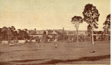 The Beechworth Burke Museum
Postcard, c1910
... ...historic victorian architecture...Mayday Mayday Hills Hospital Mayday Hills Mayday Hills Mental Asylum mayday hills mental hospital Beechworth Beechworth Asylum Beechworth Hospital for the Insane Beechworth Lunatic Asylum Beechworth Mental Hospital Healthcare health rural australia farm Architecture historic victorian architecture classical architecture Obverse: Beautiful Beechworth (Vic.) 1880 ft. above Sea Level - General View of Asylum for Insane/ Copyright F. ...Mayday Hills Mental Hospital was originally constructed in 1864 under the name of the Beechworth Lunatic Asylum. It was built for locals in need of help who were kept in the local gaol. In its first decade, the residents of the hospital were used as menial labourers but over time, as mental healthcare progressed, were cared for in more nuanced ways. This site became a training hospital for nurses in the 1960's. Eventually, mental health patients were moved to other care facilities and Mayday Hills was operating as a geriatric care facility. It was closed in 1995, after which the buildings and their grounds were purchased to La Trobe University to be used as a campus. The university sold the site in 2011 to private ownership. This postcard depicts the Mayday Hills Mental Hospital (Titled as 'Asylum for insane') from a distance and includes the surrounding grounds and farmlands.Mayday Hills Mental Hospital is a historically significant site for many factors. It is representative of healthcare practice in nineteenth century Victoria. It contains rare examples of construction and architecture. It is also significant for aesthetic and technical reasons.Sepia tone postcard printed on matte cardObverse: Beautiful Beechworth (Vic.) 1880 ft. above Sea Level - General View of Asylum for Insane/ Copyright F. Foxcroft Reverse: 1997.2459/ Post Card/ THIS SPACE MAY BE USED FOR CORRESPONDENCE/ THIS SPACE FOR NAME AND ADDRESSmayday, mayday hills hospital, mayday hills, mayday hills mental asylum, mayday hills mental hospital, beechworth, beechworth asylum, beechworth hospital for the insane, beechworth lunatic asylum, beechworth mental hospital, healthcare, health, rural australia, farm, architecture, historic victorian architecture, classical architecture -
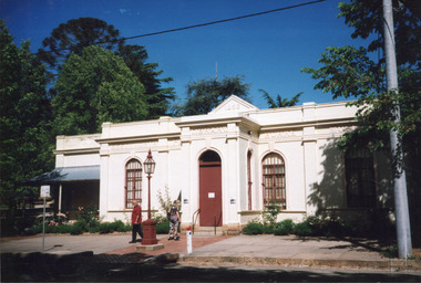 The Beechworth Burke Museum
Photograph, c1999-2000
... historic precinct...burke museum exhibition...from the liedertafel to the skating rink...honey-coloured local granite...robert o'hara burke...victorian gold fields...historic towns in victoria...colonial australia...liedertafel...colonial entertainments...beechworth brass band...historic victorian architecture...This photograph captures this distinctive character and may be compared and studied alongside other images of historic buildings in the Burke Museum Photographic Collection. burke museum indigo shire beechworth athanaeum beechworth library beechworth historic building historic precinct burke museum exhibition from the liedertafel to the skating rink honey-coloured local granite robert o'hara burke victorian gold fields historic towns in victoria colonial australia liedertafel colonial entertainments beechworth brass band historic victorian architecture australia's oldest regional museum burke and wills expedition first europeans to cross australia yound mens associations beechworth tourism things to see in beechworth beechworth historic trail young men's associations Reverse: 7031 / Label: Burke Museum / 1999/2000 / Rectangular colour photograph printed on photographic paper. ...This photograph taken c1999/2000, depicts the Burke Museum’s granite façade and vestibule entrance. The museum's large red door is closed and there is a white sign is attached to the door. The museum site dates to the 1857 founding of the Beechworth Public Library and Athenaeum by a newly formed Young Men's Association (YMA). In 1863 the museum was dedicated as a memorial to former Beechworth police superintendent (1854-1858) and explorer Robert O’Hara Burke, following Burke’s death from malnutrition on the Burke and Wills expedition in 1861. Funded by the Victorian Government and the Royal Society of Victoria, the officially titled 'Victorian Exploring Expedition' was tasked with being the first European party to traverse Australia from south to north. The Burke Museum holds objects from the famous expedition and explores the multi-layered history of Beechworth and surrounds from the gold rush era to the present.This photograph is historically significant for its depiction of the Burke Museum c1999/2000. The Burke Museum is Australia’s oldest regional museum and part of Beechworth's Historic and Cultural Precinct, one of Australia’s best preserved historic-town sites and a popular tourist destination. Once the government centre for a vast gold fields region, this collection of nationally significant buildings tells the story of how Australia grew and prospered. The frequent use of honey-coloured local granite as a building material, which can be seen in the museum's fabric, gives Beechworth’s historic buildings a distinct and cohesive local character. This photograph captures this distinctive character and may be compared and studied alongside other images of historic buildings in the Burke Museum Photographic Collection.Rectangular colour photograph printed on photographic paper.Reverse: 7031 / Label: Burke Museum / 1999/2000 /burke museum, indigo shire, beechworth athanaeum, beechworth library, beechworth historic building, historic precinct, burke museum exhibition, from the liedertafel to the skating rink, honey-coloured local granite, robert o'hara burke, victorian gold fields, historic towns in victoria, colonial australia, liedertafel, colonial entertainments, beechworth brass band, historic victorian architecture, australia's oldest regional museum, burke and wills expedition, first europeans to cross australia, yound mens associations, beechworth tourism, things to see in beechworth, beechworth historic trail, young men's associations -
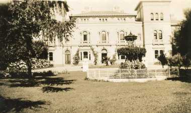 The Beechworth Burke Museum
Photograph, 1930
... ...historic victorian architecture...Mayday Mayday Hills Hospital Mayday Hills Mayday Hills Mental Asylum Beechworth Beechworth Asylum Beechworth Lunatic Asylum Beechworth Hospital for the Insane garden gardens & parks Architecture historic victorian architecture healthcare health fountain La Trobe University Reverse: Mental Hospital/ Beechworth Lunatic Asylum/ Xmas 1930/ 8190 VELOX (Watermark) Black and white photograph printed on matte photographic paper Photograph Photograph Burke Museum ...Mayday Hills Mental Hospital was originally constructed in 1864 under the name of the Beechworth Lunatic Asylum. It was built for locals in need of help who were kept in the local gaol. In its first decade, the residents of the hospital were used as menial labourers but over time, as mental healthcare progressed, were cared for in more nuanced ways. This site became a training hospital for nurses in the 1960's. Eventually, mental health patients were moved to other care facilities and Mayday Hills was operating as a geriatric care facility. It was closed in 1995, after which the buildings and their grounds were purchased to La Trobe University to be used as a campus. The university sold the site in 2011 to private ownership. This image depicts the front facade of the building and a portion of the gardens, including a fountain. Mayday Hills Mental Hospital is a historically significant site for many factors. It is representative of healthcare practice in nineteenth century Victoria. It contains rare examples of construction and architecture. It is also significant for aesthetic and technical reasons.Black and white photograph printed on matte photographic paperReverse: Mental Hospital/ Beechworth Lunatic Asylum/ Xmas 1930/ 8190 VELOX (Watermark)mayday, mayday hills hospital, mayday hills, mayday hills mental asylum, beechworth, beechworth asylum, beechworth lunatic asylum, beechworth hospital for the insane, garden, gardens & parks, architecture, historic victorian architecture, healthcare, health, fountain, la trobe university -
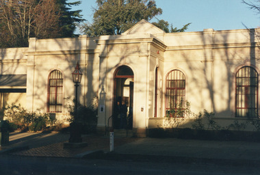 The Beechworth Burke Museum
Photograph, Unknown
... historic precinct...honey-coloured local granite...victorian gold fields...historic towns in victoria...victoria's high country...colonial australia...beechworth tourism...things to see in beechworth...beechworth historic trail...historic victorian architecture...This photograph may be compared and studied alongside other images of historic buildings in the Burke Museum Photographic Collection. burke museum beechworth athenaeum beechworth library beechworth historic precinct robert o'hara burke australia's oldest regional museum indigo shire beechworth athanaeum beechworth historic building historic precinct honey-coloured local granite victorian gold fields historic towns in victoria victoria's high country colonial australia beechworth tourism things to see in beechworth beechworth historic trail historic victorian architecture burke and wills expedition first europeans to cross australia young men's associations Reverse: 3440 Rectangular colour photograph printed on photographic paper. ...This undated photograph depicts two people standing in the vestibule entrance at the Burke Museum, Beechworth. The museum site dates to the 1857 founding of the Beechworth Public Library and Athenaeum by a newly formed Young Men's Association (YMA). In 1863 the museum was dedicated as a memorial to former Beechworth police superintendent (1854-1858) and explorer Robert O’Hara Burke, following Burke’s death from malnutrition on the Burke and Wills expedition in 1861. Funded by the Victorian Government and the Royal Society of Victoria, the officially titled 'Victorian Exploring Expedition' was tasked with being the first European party to traverse Australia from south to north. The Burke Museum holds objects from the famous expedition and explores the multi-layered history of Beechworth and surrounds from the gold rush era to the present.This photograph is historically significant for its depiction of the Burke Museum and Loch Street streetscape. The Burke Museum is Australia’s oldest regional museum and part of Beechworth's Historic and Cultural Precinct, one of Australia’s best preserved historic-town sites and a popular tourist destination. Once the government centre for a vast gold fields region, this collection of nationally significant buildings tells the story of how Australia grew and prospered. The frequent use of honey-coloured local granite as a building material, which can be seen in the museum's fabric, gives Beechworth’s historic buildings a distinct and cohesive local character. This photograph may be compared and studied alongside other images of historic buildings in the Burke Museum Photographic Collection.Rectangular colour photograph printed on photographic paper.Reverse: 3440burke museum, beechworth athenaeum, beechworth library, beechworth historic precinct, robert o'hara burke, australia's oldest regional museum, indigo shire, beechworth athanaeum, beechworth historic building, historic precinct, honey-coloured local granite, victorian gold fields, historic towns in victoria, victoria's high country, colonial australia, beechworth tourism, things to see in beechworth, beechworth historic trail, historic victorian architecture, burke and wills expedition, first europeans to cross australia, young men's associations -
 Glen Eira Historical Society
Document - Historic Conservation Areas Project
... Caulfield Library Dandenong Road Nepean Highway Hotham Street Iknerman Road Orrong Road North Road Poath Road ‘Plan of the City of Caulfield’ North Ward East Ward South Ward West Ward Kooyong Road Neerim Road Bambra Road Balaclava Road Shire of Caulfield Railways World War 1914-1918 Depression 1929-1939 Rippon Lea Labassa Parks Mansions Community Services ‘Caulfield North Draft Heritage Guidelines July 1999’ City of Glen Eira Caulfield North Heritage Area Glen Eira Heritage Management Plan Mayfield Grove Normanby Avenue Carnarvon Street Glenferrie Street Arthur Street Malakoff Street Normanby Road Heritage Advisory Service Construction Materials Victorian Style Mediterranean Style Spanish Mission Style Californian Bungalow Style Federation Style Architectural Style Architectural Features Heritage Conservation Design Building Construction Building Regulations Aboriginal Peoples Carnarvon Road Document Historic Conservation Areas Project ...Contains 4 items relating to historic conservation: 1/Five newsletters (one page each newsletter, dated 07/1975, 08/1975, 09/1975, 10/1975 and the final one 12/1975) describing how the project evolved, project funds, progress, study method, project 1 report, project 2 report and summary as no further funds available. Project was to include all of Melbourne but funding did not allow this. Note: newsletters stamped with Caulfield Historical Society. 2/Letter (one page on official city of Caulfield letterhead) from Andrew Rodda (manager planning) to Hazal Ford (dated 13/11/1989) describing ‘council resolved on 18/07/1989 to proceed with preliminary conservation survey’ and mentions that a copy is included. 3/Preliminary conservation survey for the City of Caulfield (nine pages) describing background, study area, budget, purpose, study outline, timeframe, report format, ownership, tasks and background information (mentions number and types of houses and properties as at 1986 and 1988) and a map of City of Caulfield. 4/Booklet (28 pages) titled ‘Heritage Area – Caulfield North Draft Heritage Guidelines July 1999 – City of Glen Eira’, containing Caulfield North Heritage Area, cultural heritage, Heritage Overlay Area, architectural description, common architectural forms and features, development guidelines, key design checklist. It includes a map of the Caulfield North Heritage Overlay Area, two illustrations about the development envelope and many black-and-white photographs of houses and architectural features.historic conservation areas project niven barbara, newsletters, town planning, historic buildings, heritage studies, housing, royal historical society of victoria (rhsv), read michael, plans, local government, historical societies, committee for urban action (cua), national trust, hopkins sherry ms., ford hazel, preliminary conservation survey, town planning, heritage studies, rodda andrew, city of caulfield, housing estates, victoria national estate grants program, australia icomos, burra charter, buildings structures and establishments, land surveys, suburbs, historic buildings, architectural significance, ‘caulfield’s heritage study’, soloman geulah dr., caulfield library, dandenong road, nepean highway, hotham street, iknerman road, orrong road, north road, poath road, ‘plan of the city of caulfield’, north ward, east ward, south ward, west ward, kooyong road, neerim road, bambra road, balaclava road, shire of caulfield, railways, world war 1914-1918, depression 1929-1939, rippon lea, labassa, parks, mansions, community services, ‘caulfield north draft heritage guidelines july 1999’, city of glen eira, caulfield north heritage area, glen eira heritage management plan, mayfield grove, normanby avenue, carnarvon street, glenferrie street, arthur street, malakoff street, normanby road, heritage advisory service, construction materials, victorian style, mediterranean style, spanish mission style, californian bungalow style, federation style, architectural style, architectural features, heritage conservation design, building construction, building regulations, aboriginal peoples, carnarvon road -
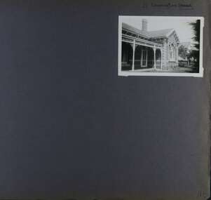 Glen Eira Historical Society
Album - Album page, Leamington Crescent, Circa 1972
... historic buildings within the City of Caulfield that warranted the protection of a National Trust Classification. Principal photographer thought to be Trevor Hart, member of Caulfield Historical Society. Most photographs were taken between 1966-1972 with a small number of photographs being older and from unknown sources. All photographs are black and white except where stated, with 386 photographs over 198 pages. trevor hart verandah arched windows leamington crescent ornate cornerstone slate roof triple windows decorative brackets eave brackets leamington street caulfield east cast iron frieze victorian architectural style cast iron work polychrome bricks Handwritten: 21 Leamington (Street) [crossed out] / Crescent [top right] / 118 [bottom right] Page 118 Photograph Album with one photograph (landscape) of a brick house at Leamington Crescent. ...This photograph is part of the Caulfield Historical Album 1972. This album was created in approximately 1972 as part of a project by the Caulfield Historical Society to assist in identifying buildings worthy of preservation. The album is related to a Survey the Caulfield Historical Society developed in collaboration with the National Trust of Australia (Victoria) and Caulfield City Council to identify historic buildings within the City of Caulfield that warranted the protection of a National Trust Classification. Principal photographer thought to be Trevor Hart, member of Caulfield Historical Society. Most photographs were taken between 1966-1972 with a small number of photographs being older and from unknown sources. All photographs are black and white except where stated, with 386 photographs over 198 pages. Page 118 Photograph Album with one photograph (landscape) of a brick house at Leamington Crescent.Handwritten: 21 Leamington (Street) [crossed out] / Crescent [top right] / 118 [bottom right]trevor hart, verandah, arched windows, leamington crescent, ornate cornerstone, slate roof, triple windows, decorative brackets, eave brackets, leamington street, caulfield east, cast iron frieze, victorian architectural style, cast iron work, polychrome bricks -
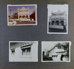 Glen Eira Historical Society
Album - Album page, Orrong Road, Circa 1972
... historic buildings within the City of Caulfield that warranted the protection of a National Trust Classification. Principal photographer thought to be Trevor Hart, member of Caulfield Historical Society. Most photographs were taken between 1966-1972 with a small number of photographs being older and from unknown sources. All photographs are black and white except where stated, with 386 photographs over 198 pages. Victorian Heritage Database https://vhd.heritagecouncil.vic.gov.au/places/35576 No. 70 Orrong Road is important as an exceptionally ornate Boom style villa residence in the terraced form and in this respect is rare in Caulfield. Its architectural ...This photograph is part of the Caulfield Historical Album 1972. This album was created in approximately 1972 as part of a project by the Caulfield Historical Society to assist in identifying buildings worthy of preservation. The album is related to a Survey the Caulfield Historical Society developed in collaboration with the National Trust of Australia (Victoria) and Caulfield City Council to identify historic buildings within the City of Caulfield that warranted the protection of a National Trust Classification. Principal photographer thought to be Trevor Hart, member of Caulfield Historical Society. Most photographs were taken between 1966-1972 with a small number of photographs being older and from unknown sources. All photographs are black and white except where stated, with 386 photographs over 198 pages.Victorian Heritage Database https://vhd.heritagecouncil.vic.gov.au/places/35576 No. 70 Orrong Road is important as an exceptionally ornate Boom style villa residence in the terraced form and in this respect is rare in Caulfield. Its architectural value is enhanced by its intact state and by the manner in which its bold architectural expression is carried through into the hallway and staircase. Victorian Heritage Database - National Trust local significance 284 Orrong Road Caulfield https://vhd.heritagecouncil.vic.gov.au/places/65700 A house designed by Harold Desbrowe Annear in 1917 and believed to have been the first "all electric" house in Melbourne. It has been extensively altered.Page 164 - four photographs of 2 different houses on Orrong Road. The top left photo is in colour while the others are in black and white.Handwritten: Orrong Road [top right] / Lisborn House [ (ed. correct name is LISBON HOUSE), under top left photo] / Lisborn House [under top right photo] / [under bottom right photo] / CORNER ORRONG ROAD AND PEARSON AVENUE / HOUSE BY DESBROWE ANNEAR [under bottom left photo] / 164 [bottom right]trevor hart, orrong road, lisbon house, lisborn house, elsternwick, pearson grove, st kilda east, caulfield north, terrace houses, cast iron work, verandahs, balconies, parapets, arches, cars, streetscapes, attic houses, desbrowe annear -
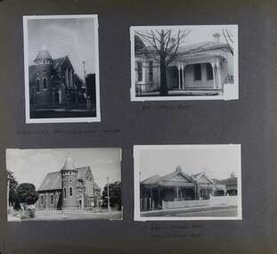 Glen Eira Historical Society
Album - Album page, Orrong Road, Circa 1972
... historic buildings within the City of Caulfield that warranted the protection of a National Trust Classification. Principal photographer thought to be Trevor Hart, member of Caulfield Historical Society. Most photographs were taken between 1966-1972 with a small number of photographs being older and from unknown sources. All photographs are black and white except where stated, with 386 photographs over 198 pages. Victorian Heritage Database H0704 FORMER UNION CHURCH 84-86 ORRONG ROAD ELSTERNWICK https://vhd.heritagecouncil.vic.gov.au/places/428 The Former Union Church, Elsternwick, designed by the architect George de Lacy Evans, and erected in 1889-90 is a building of historical and architectural ...This photograph is part of the Caulfield Historical Album 1972. This album was created in approximately 1972 as part of a project by the Caulfield Historical Society to assist in identifying buildings worthy of preservation. The album is related to a Survey the Caulfield Historical Society developed in collaboration with the National Trust of Australia (Victoria) and Caulfield City Council to identify historic buildings within the City of Caulfield that warranted the protection of a National Trust Classification. Principal photographer thought to be Trevor Hart, member of Caulfield Historical Society. Most photographs were taken between 1966-1972 with a small number of photographs being older and from unknown sources. All photographs are black and white except where stated, with 386 photographs over 198 pages. Victorian Heritage Database H0704 FORMER UNION CHURCH 84-86 ORRONG ROAD ELSTERNWICK https://vhd.heritagecouncil.vic.gov.au/places/428 The Former Union Church, Elsternwick, designed by the architect George de Lacy Evans, and erected in 1889-90 is a building of historical and architectural significance for the following reasons:- (1) it is a rare and well- developed example of the early French Gothic manner as popularised through the muscular Victorian re-interpretation of English architect William Burgess, which in turn were derived from the publications of EE Viollet-le-Duc. Other Victorian cases of detailing derived from Viollet-le-Duc include Barwon Park (1868), the Presbyterian Church at Skipton (1871), the Bourke Street West Police Station by Bindley and Brittingham (PWD) dating from 1888-9 and the Lutheran Manse, East Melbourne by JAB Koch (1890). However, none of these buildings relates closely in form to the Union Church, Elsternwick. The only building which has been identified as closely comparable is The Bairnsdale Court House by AJ Macdonald (PWD) which dates from 1892. (2) the use of bright red brickwork is of significance, as the Former Union Church is believed to be only the second church building in Victoria to employ this material as a matter of conscious choice. Amongst red brick churches, it is thought to be preceded only by Reed, Henderson And Smart's Sacred Heart (1884), a Renaissance inspired design. (3) the building is believed to be a rare, possibly unique, surviving example of a church building erected for dual use by the Congregationalists and Baptists. In 1894 it was bought by the Congregationalists and continued as a Congregational Church until the formation of the Uniting Church.Page 165 of Photograph Album with four photographs, two of a church with the other two of houses on Orrong Road.Handwritten: ELSTERNWICK CONGREGATIONAL CHURCH [under top left photo] / 82 ORRONG ROAD [under top right photo] / 663-1 ORRONG ROAD / SEMI - DETACHED PAIR / 165 [bottom left]trevor hart, elsternwick congregational church, king street, orrong road, church, elsternwick, red brick, former union church, early french gothic style, architects, george de lacy evans, baptist church, conical towers, houses -
Glen Eira Historical Society
Letter - ELSTERNWICK POST OFFICE
... Architects Builders architectural features Australia Post Register of Historical Buildings Grey Karen Planning Appeal Board Heritage Overlay No H029 Victorian Government Gazette No. 60 dated 16/07/1986 Historic Building No640 Certificate of Title Volume 5817 Kennan James Harley Nelson Ivor Blake Alison Neale Anne telegraph offices Wardell Ward Andrew Letter ELSTERNWICK POST OFFICE ...This file contains seven items about the significance of this building and how this was established : 1/ Photocopies of a handwritten application (in duplicate) by Walter Kay of Elsternwick dated 13/10/1985 and Rodney H Bush’s dated 16/10/1985 to the Historic Buildings Council to register the former Elsternwick Post Office building, and an original typewritten letter dated 17/10/1985 from the Historic Buildings Council to Caulfield and Historic Society advising them of an application and inviting them to submit relevant information about the building with a copy of application attached. 2/ Six pieces of correspondence between various interested parties (Caulfield Council , Caulfield Historical Society, National Trust, of Australia and Ministry for Planning and Environment on behalf of Historic Buildings Council, Victoria) about the significance of the former Elsternwick Post Office building and the progress of efforts to include it on the Register of Historic buildings. Dated between November 1985 and May 1986. 3/ Two pieces of correspondence between the Caulfield Progress Association and the Caulfield Historical Society dated April and May 1986, regarding the efforts of the Historical Society to save the former Elsternwick Post Office building. 4/ Two pieces of ephemera by the Caulfield Progress Association, one original undated and one photocopy undated in 1986. Both appealing to the public for support to help the former Elsternwick Post Office building and to protest a proposal to demolish it, by Caulfield Council. 5/Original newspaper article dated 07/06/1989 from the Malvern-Caulfield Progress newspaper written by Robert Carmody. The article talks about the approval by the Historic Buildings Council of Caulfield Council’s restoration program of the former Elsternwick Post Office building worth approximately $850,000. The refurbishment would consist of a shop and office space which would then be rented out. Mayor Emil Braun outlines the progress to implement the plans. 6/ Caulfield Conservation Study by Andrew Ward dated September 1994 of former Elsternwick Post Office Building. The building plans for the Elizabethan Style building were approved in 1891. The original timber verandahs were replaced by the present brickworks in circa 1918 rear extensions in 1941-42. Similar Post Offices were built at Kew, Queenscliff and Portarlington. 7/ Computer printout dated 19/03/2010 of Statement of Significance held by the Victorian Heritage database of the former Elsternwick Post Office Building. It was built in 1891 in the ‘Queen Anne’ style. The substantial two story red brick building was set on a bluestone plinth with an ornate façade incorporating cement dressings. There is a brief summary of the settlement and development of the Elsternwick area with mention of how important the building is to the Elsternwick Community. Original date and author is unknown.elsternwick post office, glenhuntly road, elsternwick, riddell parade, office buildings, postal services, caulfield city council, kay walter, regent street, caulfield, bush rodney h, gisborne street, city of caulfield, braun emil councillor, mayors, aylen doug, aylen douglas r, historic buildings council, caulfield historical society, ministry for planning and environment, head stephen, historic buildings act 1981, anderson p, national trust of australia (victoria), public works department, architectural styles, calder g.k. councillor, wills cathie, lyall kerry, marsden john hudson, town clerk, hill douglas, caulfield progress association, caulfield south, glen eira road, hawthorn road, mac neil j.r., neville street, glenhuntly, marten veronika, ballantyne richard, royal historical society of victoria, dunstan don, alfada street south, hardy joan, baird rob, snowball betty, ward andrew, hoddle robert, foot henry, ebden charles hodson, elster, oldham mary kate, english ‘queen anne’ revival style, rifle club, coulson herbert h., fick p.g., railway, city manager, austin g.b. h., architects, builders, architectural features, australia post, register of historical buildings, grey karen, planning appeal board, heritage overlay no h029, victorian government gazette no. 60 dated 16/07/1986, historic building no640, certificate of title volume 5817, kennan james harley, nelson ivor, blake alison, neale anne, telegraph offices, wardell, ward andrew -
Glen Eira Historical Society
Letter - Elsternwick Congregational Church – Caulfield Union Church
... Victorian Music Theatre Pty Ltd to Conduct singing lessons in the church building. Typed letter dated 08/12/1987 from National Trust to St. John’s Parish noting the Trust’s classification of the church building and the accompanying citation. Typed letter dated 20/07/1988 from the historic buildings council to Caulfield Historical Society concerning the hearing to discuss inclusion of the church building on the register to be held on 24/08/1988. Copy of historic building council’s agenda item undated describing the significance of the former Union Church. Thirteen page assessment of the architectural...Victorian Music Theatre Pty Ltd to Conduct singing lessons in the church building. Typed letter dated 08/12/1987 from National Trust to St. John’s Parish noting the Trust’s classification of the church building and the accompanying citation. Typed letter dated 20/07/1988 from the historic buildings council to Caulfield Historical Society concerning the hearing to discuss inclusion of the church building on the register to be held on 24/08/1988. Copy of historic building council’s agenda item undated describing the significance of the former Union Church. Thirteen page assessment of the architectural ...One page of Caulfield Council’s E.S. and P. Committee agenda, item and minutes dated 14/05/1971 concerning permit application from St. John’s Uniting Church for the Victorian Music Theatre Pty Ltd to Conduct singing lessons in the church building. Typed letter dated 08/12/1987 from National Trust to St. John’s Parish noting the Trust’s classification of the church building and the accompanying citation. Typed letter dated 20/07/1988 from the historic buildings council to Caulfield Historical Society concerning the hearing to discuss inclusion of the church building on the register to be held on 24/08/1988. Copy of historic building council’s agenda item undated describing the significance of the former Union Church. Thirteen page assessment of the architectural significance of the former Union Church dated 24/08/1988 by Anne Neale. Includes sketch of the exterior and references. Handwritten notations by Jim O’Loghlin dated 24/08/1988. Photocopy of the page from the Victoria Government Gazette dated 05/10/1988 advertising the amendment of the register of historic buildings to include the former Union Church building. A twelve page document produced by the Historic Buildings Council Victoria, date unknown, which describes the council’s operations and activities.st. john’s parish of the uniting church, e.s. and p. committee, congregational church, orrong road, victorian music theatre pty ltd, king street, glen huntly road, melbourne neon ltd, balaclava road, whiteway neon p.l., n. and d. panagiotou, nepean highway, h.c. sleigh ltd., poath road, carden w. j., warren r.p., talbot avenue, new l. mrs., elsternwick, zoning, st. georges road, architectural features, caulfield union church, towers, de lacy evans george, mcmurtie mcnaughton and stewart, glen eira road, neale anne i., mcloghlin jim, architectural styles, gothic style, caulfield, caulfield historical society, gregson w. rev., st. aloysius caulfield, brick -
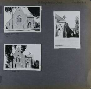 Glen Eira Historical Society
Album - Album page, St Mary's Anglican Church, Glen Eira Road, Circa 1972
... historic buildings within the City of Caulfield that warranted the protection of a National Trust Classification. Principal photographer thought to be Trevor Hart, member of Caulfield Historical Society. Most photographs were taken between 1966-1972 with a small number of photographs being older and from unknown sources. All photographs are black and white except where stated, with 386 photographs over 198 pages. From the Victorian Heritage Register Database - Citation for St Mary's Anglican Church https://vhd.heritagecouncil.vic.gov.au/places/43715 (as at 14/10/2020) St Mary's has architectural ...This photograph is part of the Caulfield Historical Album 1972. This album was created in approximately 1972 as part of a project by the Caulfield Historical Society to assist in identifying buildings worthy of preservation. The album is related to a Survey the Caulfield Historical Society developed in collaboration with the National Trust of Australia (Victoria) and Caulfield City Council to identify historic buildings within the City of Caulfield that warranted the protection of a National Trust Classification. Principal photographer thought to be Trevor Hart, member of Caulfield Historical Society. Most photographs were taken between 1966-1972 with a small number of photographs being older and from unknown sources. All photographs are black and white except where stated, with 386 photographs over 198 pages.From the Victorian Heritage Register Database - Citation for St Mary's Anglican Church https://vhd.heritagecouncil.vic.gov.au/places/43715 (as at 14/10/2020) St Mary's has architectural significance as a representative example of French influenced Low and Mixed Gothic (see stylistic Typology in National Trust's Historic Churches Study) and is further distinguished by its use of bluestone, entirely without relief. French influence is demonstrated by the high nave, apsidal sanctuary, spirelet and trumeau. The building is locally important as a historic focus for Anglican worship and early mission activity whilst its architectural grandeur is expressive of mid Victorian Caulfield's status as a suburban location for the Metropolis gentry.Page 56 of Photograph Album with three exterior photographs (two portrait and one landscape) of St Mary's Anglican Church.Hand written: St Mary's Anglican Church Eira Road [top right] / Neg 235 8 Oct 1966 [under top left photo] / 3 Sep 1972 [under bottom left photo] / 56 [bottom right] trevor hart, 1880's, elsternwick, glen eira road, st kilda east, church of england, gothic, st mary's, bluestone, apsidal sanctuary, spirelet, trumeau, anglican, 1870's, caulfield north, french-influenced low and mixed gothic style -
 Glen Eira Historical Society
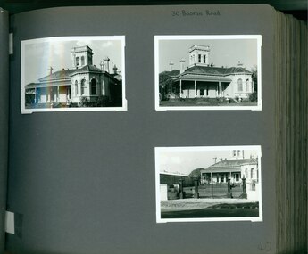
Album - Album page, Booran Road, 30, Circa 1972
... Along with 'Lord' a number of well known racehorses including Sobar, Havelock, Proud and Future were trained at Lord Lodge ..... trevor hart jenny o'donnell booran road mansion caulfield east ingliston sobar havelock proud future lord andover moidart lord lodge grace darling caulfield racecourse reserve victorian amateur turf club historic buildings register national estate register caulfield cup horses stables horse racing racehorses outbuildings racehorse trainers depression 1890s brick houses mansions towers verandahs stained glass italianate style victorian style architectural features architectural styles john leek leslie macdonald john arthur john robertson alfred merrill jenny odonnell Handwritten: 30 Booran Road [top right hand corner] / 40 [bottom right] Page 40 of Photograph Album with three landscape photographs of the exterior of this house. ...This photograph is part of the Caulfield Historical Album 1972. This album was created in approximately 1972 as part of a project by the Caulfield Historical Society to assist in identifying buildings worthy of preservation. The album is related to a Survey the Caulfield Historical Society developed in collaboration with the National Trust of Australia (Victoria) and Caulfield City Council to identify historic buildings within the City of Caulfield that warranted the protection of a National Trust Classification. Principal photographer thought to be Trevor Hart, member of Caulfield Historical Society. Most photographs were taken between 1966-1972 with a small number of photographs being older and from unknown sources. All photographs are black and white except where stated, with 386 photographs over 198 pages. From Glen Eira Heritage Management Plan 1996 by Andrew Ward: In 1888, John Leek, a trainer, owned Lot 15, measuring one and three quarter acres, in Booran Road, north side between Glen Eira and Neerim Roads. The land backed onto the Caulfield Racecourse Reserve. NAV was £45. In 1890 Leek built for his residence, a ten roomed brick house on the site. NAV was £200. Leek was the owner/trainer of "Ingliston" who won the Caulfield Cup in 1900. Upon the horse's death in 1901, Leek is understood to have defied tradition by spending £20 on boots for the "ragged urchins in Bourke Street" instead of "shouting" at the bar. By 1899, the property was owned and occupied by Alfred Merrill, a dentist and was known as "Andover". NA V had decreased to £ll0. By 1910, Leslie Macdonald, a gentleman had purchased the property and renamed it "Moidart". In 1910-11 Macdonald sold it to John Robertson. The property had extensive wood stables on its north-east boundary and several other outbuildings. The house continued to be described as "Brick, ten rooms" as it was in 1926 when it was owned and occupied by John Arthur, a managing director. The land measured la.2r.31p. and had a NAV of £235. Nine people lived there. In 1926, Arthur also owned the adjoining Lot 16. Other racehorses of note, known to have been stabled here include Sobar, Havelock, Proud, Future and Lord.Victorian Heritage Register https://vhd.heritagecouncil.vic.gov.au/places/13532 What is significant? Lord Lodge is a thoroughbred racehorse training complex adjacent to Caulfield Racecourse, established in 1890. The area immediately around the racecourse has been associated with horse racing activities and businesses servicing the industry since the development of the racecourse in late the 19th century. Lord Lodge was named by the present occupants after the champion racehorse Lord who was stabled there in the 1950s. In the early 20th century the property was known as 'Andover' and subsequently 'Moidart'. The site consists of a single storey brick Italianate villa, jockeys' quarters, stables and open day yards with direct access to Caulfield racecourse from the rear of the property. The villa of 10 rooms on bluestone foundations was constructed in 1890 by John Leek, a horse trainer who purchased the newly subdivided land in 1888. The house has many Victorian Italianate or Boom Style features although it is more modest than many villas of its style. It has an asymmetrical facade with a faceted bay window and a prominent central tower with low pitch pyramidal roof that provides a clear view of the racecourse. Other characteristic features include stilted segmented arches, bracketed eaves, stucco wall finish and cast cement ornamentation. A room has been added on the north-facing verandah in sympathetic style and finish. Internally the rooms are substantially intact with original marble fireplaces and intricate ceiling roses and cornices. An entrance toward the rear of the southern side of the house is said to be where the stable hands, jockeys and other staff lined up for their meals. In the southeast corner of the property, backing directly on to Caulfield racecourse, is a substantial late Victorian timber stable, probably constructed in the 1890s but first appearing on the property title in 1910. The stable has 12 stalls, a loft and brick pavement and jerkin head roof form with varnished pine-lined ceiling carried on a chamfered timber frame. It has an original roof lantern. The doors of the stalls are not the original sliding doors but swing doors obtained from a barn at Epsom Racecourse in Mordialloc prior to demolition. Outside the gambrel roof has fretted barges but the building is otherwise utilitarian. Timber throughout the stalls has been worn by chewing and rubbing of horses over the century of its use. In the southern half of the property are open day yards where the racehorses are kept during the day. The red brick, single storey jockeys' quarters to the rear of the villa were probably built around 1950. A small brick, possibly late Victorian structure on the eastern boundary thought to have originally been a gardening shed, has been converted to a stable of two stalls. Modern concrete brick stables fill the northeast portion of the property. At the front of the property two Moreton Bay Figs (Ficus macrophylla), probably planted in the late 19th century, provide shade for horses in the day yards. In the 1890s John Leek sold the property, relocating his training facility to one of the newly established racecourses at Mentone or Mordialloc (Epsom). By 1899, the property was owned and occupied by Alfred Merrill, a dentist, who named the property 'Andover'. In 1910 it was purchased by Leslie McDonald, a gentleman, and renamed 'Moidart'; sold in 1910-1911 to John Robertson; and again in 1926 to John Arthur, a racehorse owner. The Victorian Amateur Turf Club purchased the property in the late 1930s and since this time has been leased to racehorse trainers. It is unclear whether the property operated as a training facility between 1899 - 1926. Several notable trainers and jockeys are associated with Lord Lodge. The best known is Arthur 'Scobie' Breasley, Australia's most successful jockey who was apprenticed to trainer Pat Quinlan at Lord Lodge (then 'Moidart') from 1928 - 1935. Breasley rode winners of the Caulfield Cup in four successive years 1942-45 and again in 1952. John Leek, the original owner of Lord Lodge trained Ingliston, the 1900 Caulfield Cup winner. Along with 'Lord' a number of well known racehorses including Sobar, Havelock, Proud and Future were trained at Lord Lodge .....Page 40 of Photograph Album with three landscape photographs of the exterior of this house.Handwritten: 30 Booran Road [top right hand corner] / 40 [bottom right]trevor hart, jenny o'donnell, booran road, mansion, caulfield east, ingliston, sobar, havelock, proud, future, lord, andover, moidart, lord lodge, grace darling, caulfield racecourse reserve, victorian amateur turf club, historic buildings register, national estate register, caulfield cup, horses, stables, horse racing, racehorses, outbuildings, racehorse trainers, depression, 1890s, brick houses, mansions, towers, verandahs, stained glass, italianate style, victorian style, architectural features, architectural styles, john leek, leslie macdonald, john arthur, john robertson, alfred merrill, jenny odonnell -
 Glen Eira Historical Society
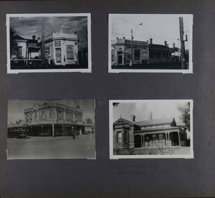
Album - Album page, Kambrook Road, Circa 1972
... historic and aesthetic significance. It is historically significant (Criterion A) as the home of an inner suburban industrialist, notable a boot manufacturer, demonstrating the attraction of Caulfield as a residential location for the manufacturers of the metropolis during the late Victorian Boom period. It is aesthetically significant (Criterion E) as a very early example of a Queen Anne influenced late Victorian villa, comparing at the State level with ''Woodlands'' (1888), North Essendon, generally acknowledged to be one of Australia's earliest houses to fully exploit this emerging style. The ornamental timberwork is especially expressive of the new architectural ...This page of photographs is part of the Caulfield Historical Album 1972. This album was created in approximately 1972 as part of a project by the Caulfield Historical Society to assist in identifying buildings worthy of preservation. The album is related to a Survey the Caulfield Historical Society developed in collaboration with the National Trust of Australia (Victoria) and Caulfield City Council to identify historic buildings within the City of Caulfield that warranted the protection of a National Trust Classification. Principal photographer thought to be Trevor Hart, member of Caulfield Historical Society. Most photographs were taken between 1966-1972 with a small number of photographs being older and from unknown sources. All photographs are black and white except where stated, with 386 photographs over 198 pages. First 2 images: milkbar and residence corner Kambrook and Balaclava Roads ie south west corner - building named Airdrie 3rd image: https://vhd.heritagecouncil.vic.gov.au/places/43737 - re 26 Kambrook Road and 345 Balaclava Road corner building ie south east corner: A prominently situated two-storeyed complex of late Victorian buildings consisting of "Wybar's Buildings" occupying the Balaclava Road/ Kambrook Road corner and the "Caulfield Bakery" facing Kambrook Road, separated by a driveway from a single storeyed shop. The main building has a comer splay and balustraded parapet with curved pediments, the words "Wybar's Buildings 1887" having been obliterated but "Caulfield Bakery 1887" with the characteristic wheatsheaf surviving in raised cement work. The walls are stuccoed and richly ornamented with bracketed cornices and keystones with masks extending to the Bakery. The main building is further distinguished by the Masonic symbol of the mason's dividers in the pediment whilst the upper level of the bakery is in overpainted brickwork. The single storeyed shop incorporates the bracketed cornice and consoles characteristic of the main buildings and is in other respects a utilitarian structure. 4th image: https://vhd.heritagecouncil.vic.gov.au/places/42415 (on 24/01/2021) - 196 Kambrook Road An imposing late Victorian poly-chrome brick asymmetrical villa with corner verandah and projecting west facing wing with faceted window bay to the facade. Body bricks are red and relieved by cream and black brick banding and by cream bricks to the bracketed eaves. The fretted barge with king post treatment and timber posted verandah are unique in the Municipality and unusual in the metropolitan area and demonstrate an understated appreciation of the emerging Queen Anne mode.345 Balaclava and 26 Kambrook Roads HO91 - City of Glen Eira https://vhd.heritagecouncil.vic.gov.au/places/43737 (on 24/01/2021) "Wybar's Buildings" at the corner of Balaclava Road and Kambrook Road are important as a prominent late Victorian commercial development incorporating a variety of activities including a bakery and possibly a coffee palace, the latter understood to be unique within the municipality, but characteristic of the period. It is a rare complex of its type in Caulfield and is important also as evocative evidence of the late Victorian Land Boom and the creation of a small now defunct commercial centre at this location by the George Wybrow. 196 Kambrook Road HO122 - City of Glen Eira https://vhd.heritagecouncil.vic.gov.au/places/42415 "Glencoe" is situated at no. 196 Kambrook Road, Caulfield North and was built for the boot manufacturer, Robert Bruce Mair, in 1888. It is of historic and aesthetic significance. It is historically significant (Criterion A) as the home of an inner suburban industrialist, notable a boot manufacturer, demonstrating the attraction of Caulfield as a residential location for the manufacturers of the metropolis during the late Victorian Boom period. It is aesthetically significant (Criterion E) as a very early example of a Queen Anne influenced late Victorian villa, comparing at the State level with ''Woodlands'' (1888), North Essendon, generally acknowledged to be one of Australia's earliest houses to fully exploit this emerging style. The ornamental timberwork is especially expressive of the new architectural fashion and compares with the house at 33 Clarence Street, Elsternwick (1888-89).Page 105 of Photograph Album with two photographs of a milk bar and attached residence, one older photograph of Wybar's Building and another photograph of a house on Kambrook Road (all are landscape).Handwritten: 196 KAMBROOK ROAD / 1970 - GAFFNEY MRS S.M. [under bottom right photo] / 100 [bottom left]trevor hart, kambrook road, victorian style, caulfield north, parapets, wybar's buildings 1887, caulfield bakery 1887, architectural features, painted bricks, balaclava road, george wybrow, shops, milk bars, airdrie, polychrome bricks, verandahs, queen anne architectural style, houses, glencoe, robert mair -
 Glen Eira Historical Society
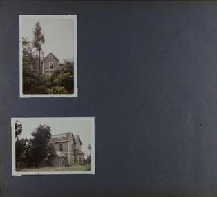
Album - Album page, Royston, Kooyong Road, Circa 1972
... historic buildings within the City of Caulfield that warranted the protection of a National Trust Classification. Photographers Jenny O’Donnell and Trevor Hart, members of Caulfield Historical Society. Some photographs are older and from unknown sources. All photographs are black and white except where stated. Vol 1 of 4 "Caulfield's Heritage" p34 states that this mansion was demolished in 1972. trevor hart caulfield north kooyong road 1860's mansion ornamented corner stones royston renwick curved windows ruins bay windows victorian architectural style polychrome bricks abandoned buildings Handwritten: 115 [bottom left] Page 115 of Photograph Album with two colour photographs (one portrait and one landscape) of different views Royston in its garden. ...This photograph is part of the Caulfield Historical Album 1972. This album was created as part of a project from approximately 1966-1972 by the Caulfield Historical Society to assist in identifying buildings worthy of preservation. This album is related to a Survey the Caulfield Historical Society developed in collaboration with the National Trust of Australia Victoria and Caulfield City Council to identify historic buildings within the City of Caulfield that warranted the protection of a National Trust Classification. Photographers Jenny O’Donnell and Trevor Hart, members of Caulfield Historical Society. Some photographs are older and from unknown sources. All photographs are black and white except where stated. Vol 1 of 4 "Caulfield's Heritage" p34 states that this mansion was demolished in 1972.Page 115 of Photograph Album with two colour photographs (one portrait and one landscape) of different views Royston in its garden.Handwritten: 115 [bottom left]trevor hart, caulfield north, kooyong road, 1860's, mansion, ornamented corner stones, royston, renwick, curved windows, ruins, bay windows, victorian architectural style, polychrome bricks, abandoned buildings -
Glen Eira Historical Society
Article - Creebank, 1 Carnarvon Road, Caulfield North
... Creebank Mansions North Caulfield Caulfield North House auctions Historic buildings Architectural styles Victorian styles Architectural features Cast iron work Real estate agents Carnarvon Road Dandenong Road Article Creebank, 1 Carnarvon Road, Caulfield North ...Original article from the real estate section of The Age newspaper, dated 08/10/1988. The article is written by Veronica Ridge and describes in detail the house at 1 Carnarvon Road, Caulfield North, called Creebank, to be auctioned 16/10/1988. The article includes a sketch (40mm x 56mm) of the house’s exterior.creebank, mansions, north caulfield, caulfield north, house auctions, historic buildings, architectural styles, victorian styles, architectural features, cast iron work, real estate agents, carnarvon road, dandenong road -
Glen Eira Historical Society
Document - Cumbernauld, formerly Thornleigh Grange, 504, Hawthorn Road, Caulfield South
... Cumbernauld Thornleigh Grange Hawthorn Road Saturn Street Caulfield South South Caulfield Ki Hong Sam Sing Cleland Thomas Wood J Cleland Annie Mathieson William James Hawthorn Road Tramway Estate Caulfield Conservation Study Victorian style Historic buildings Market gardeners Glenmore St Georges Road Ripponlea Ward Andrew Wawn Alexander Architectural styles Market gardens Chinese community Document Cumbernauld, formerly Thornleigh Grange, 504, Hawthorn Road, Caulfield South ...A photocopy of a Caulfield Conservation Study by Andrew Ward, dated 08/1994, on the house at 504 Hawthorn Road, St Kilda East, called Cumbernauld. This assessment include a brief description of the house, a history of occupancy, a short statement of significance and a black and white photograph (100mm x 152mm) of the exterior of the house.cumbernauld, thornleigh grange, hawthorn road, saturn street, caulfield south, south caulfield, ki hong, sam sing, cleland thomas, wood j, cleland annie, mathieson william james, hawthorn road tramway estate, caulfield conservation study, victorian style, historic buildings, market gardeners, glenmore, st georges road, ripponlea, ward andrew, wawn alexander, architectural styles, market gardens, chinese community -
Glen Eira Historical Society
Document - Lord Lodge, Booran Rd 30 – Andover (1899) Moidart (1910)
... architectural features of Lord Lodge. Three photocopies of photographs are included. The front view of the house, the external view of the stables and an internal view of the stables. Leek John Merrill Alfred Macdonald Leslie Arthur John Robertson John Ward Andrew Ingliston Sobar Havelock Proud Future Lord Andover Moidart Lord Lodge Grace Darling Caulfield East Booran Rd Glen Eura Rd Neerim Rd Caulfield Racecourse Reserve Victorian Amateur Turf Club Historic Buildings Register National Estate Register Caulfield Cup Horses Stables Horse Racing Racehorses Outbuildings Racehorse Trainers Depression 1890s Brick houses Mansions Towers Verandahs Stained Glass Italianate Style Victorian Style Architectural Features Architectural Styles Document Lord Lodge, Booran Rd 30 – Andover (1899) Moidart (1910) ...A photocopy of a 4 page extract from the Caulfield Conservation Study of the house and stables at 30 Booran Rd, conducted January 1995 by Andrew Ward. This document details the history of the property, including its 3 names Andover (1899), Moidart (1910) and Lord Lodge and lists previous owners. It also describes in detail the architectural features of Lord Lodge. Three photocopies of photographs are included. The front view of the house, the external view of the stables and an internal view of the stables.leek john, merrill alfred, macdonald leslie, arthur john, robertson john, ward andrew, ingliston, sobar, havelock, proud, future, lord, andover, moidart, lord lodge, grace darling, caulfield east, booran rd, glen eura rd, neerim rd, caulfield racecourse reserve, victorian amateur turf club, historic buildings register, national estate register, caulfield cup, horses, stables, horse racing, racehorses, outbuildings, racehorse trainers, depression 1890s, brick houses, mansions, towers, verandahs, stained glass, italianate style, victorian style, architectural features, architectural styles -
Glen Eira Historical Society
Document - Nettalie
... architectural features and historical significance. A bibliography is included as well as a photograph of the front facade of Nettalie which like the study includes two copies but of varying sizes. Ward Andrew Forsyth William Forsyte William Noall William Grimwade Frederick Shepherd Desailly Alfred Bryant Bessie Bryant Herbert Ware Martha Cameron William Nettalie Balaclava Road Orrong Road Caulfield North Fosbery Ave Netley Harleston Caulfield North Historic Building Register National Estate Register National Trust Register Melbourne Grammar School Cast iron work Verandahs Victorian style Stained glass Architectural features Architectural styles Brick houses Stables Mansions Pharmacists Lawyers Doctors Flats Schools Bay windows Land values Document Nettalie ...Two photocopies of the October 1994 Caulfield Conservation Study by Andrew Ward of the house at 73 Balaclava Rd Caulfield named Nettalie by 1899. In the documents(s) Ward details the history of ownership and land values the architectural features and historical significance. A bibliography is included as well as a photograph of the front facade of Nettalie which like the study includes two copies but of varying sizes.ward andrew, forsyth william, forsyte william, noall william, grimwade frederick shepherd, desailly alfred, bryant bessie, bryant herbert, ware martha, cameron william, nettalie, balaclava road, orrong road, caulfield north, fosbery ave, netley, harleston, caulfield north, historic building register, national estate register, national trust register, melbourne grammar school, cast iron work, verandahs, victorian style, stained glass, architectural features, architectural styles, brick houses, stables, mansions, pharmacists, lawyers, doctors, flats, schools, bay windows, land values -
 Bendigo Historical Society Inc.
Book - HISTORIC BUILDINGS OF VICTORIA, 1966
... architecture...Victorian buildings... architecture... historic...History House 11 Mackenzie Street Bendigo goldfields VICTORIA History architecture Victorian buildings architecture historic buildings David Saunders Historic Buildings of Victoria 278 pages, with photos , illustrations and maps. ...Historic Buildings of Victoria 278 pages, with photos , illustrations and maps.David Saundersvictoria, history, architecture, victorian buildings, architecture, historic buildings -
 The Beechworth Burke Museum
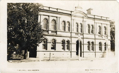
Photograph - Postcard, Town Hall Beechworth, c1910
... architectural significance for its construction from local honey coloured granite, which also showcases early stone masonry techniques and craftsmanship. The Precinct is listed on the Victorian Heritage register and is protected by Heritage Victoria under the Victorian Heritage Act 2017. The buildings are also registered by the National Estate, the National Trust and protected by Indigo Shire Council’s Planning Scheme. Beechworth beechworth town hall town hall JJ Coe Thomas Dalziel granite beechworth historic ...Beechworth Town Hall was designed by architects J.J. Coe and Thomas Dalziel and is dated to 1859. The building was made of granite and constructed to local builders Donald and William Fiddes. The original front to the building was replaced by a two story facade in 1889 designed by George Jobbins and built by Thomas Sandham according to a plaque on the front. The Town Hall is remarkable for its vaulted ceilings and columns. Originally the building was used as the Shire Offices but also doubled as a fire station and a courthouse, with still surviving cells underneath. Among the inmates was notorious bushranger Harry Power who was originally transported to Van Dieman’s Land for stealing a pair of shoes. He gained his freedom six years later but spent time in and out of gaol for the rest of his life for a variety of offences including a number of armed robberies. The Town Hall is now home to the Visitor Information Centre which helps visitors with amongst other things, accommodation, tours, event enquiries, and is the commencement point for Precinct walking tours. The Beechworth Town Hall is one of five distinctive granite buildings on Ford Street that comprise the Justice Precinct. It is of considerable historical significance as activity on the site dates from Australia’s gold rush period and was the administrative centre for north-eastern Victoria. The building has seen continual use from 1858 as an important public building and displays many aspects of the history of law enforcement in Victoria. The building is also of substantial architectural significance for its construction from local honey coloured granite, which also showcases early stone masonry techniques and craftsmanship. The Precinct is listed on the Victorian Heritage register and is protected by Heritage Victoria under the Victorian Heritage Act 2017. The buildings are also registered by the National Estate, the National Trust and protected by Indigo Shire Council’s Planning Scheme. Black and White rectangular postcard printed on cardReverse: 1906-1910?beechworth, beechworth town hall, town hall, jj coe, thomas dalziel, granite, beechworth historic building, courthouse, cells, geoge jobbins, thomas sandham, 1859, 1889, walking tours, beechworth historic precinct, historic precinct, harry power, bushranger, australian bushrangers, van dieman's land, transportation, armed robberies -
 Bendigo Historical Society Inc.
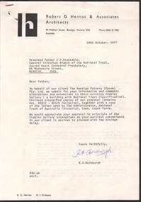
Document - National Trust Collection: Bendigo Pottery (Epsom) Pty Ltd - Two letters providing architectural comment on proposed alterations and extensions to the existing stables buildings, 14/10/2025
... History House 11 Mackenzie Street Bendigo goldfields historic significant of Bendigo Pottery physical assets Bendigo Pottery Bottle Kilns Bendigo Pottery stables conversion to shop National Trust - Two letters exchanged between R.A. Horsburgh of Robert Herriot & Associates, Architects (27 & 28 October 1977) and the Central Victorian Branch of the National Trust (28 November 1977) providing architectural comment (with five dot points) on proposed alterations and extensions to the existing stables buildings at the Bendigo Pottery Document National Trust Collection: Bendigo Pottery (Epsom) Pty Ltd - Two letters providing architectural comment on proposed alterations and extensions to the existing stables buildings ...historic significant of Bendigo Pottery physical assets National Trust - Two letters exchanged between R.A. Horsburgh of Robert Herriot & Associates, Architects (27 & 28 October 1977) and the Central Victorian Branch of the National Trust (28 November 1977) providing architectural comment (with five dot points) on proposed alterations and extensions to the existing stables buildings at the Bendigo Potterybendigo pottery bottle kilns, bendigo pottery stables conversion to shop -
 Bendigo Historical Society Inc.
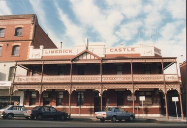
Administrative record - National Trust Collection: Limerick Castle Hotel, 259 Williamson Street, Bendigo, 1986
... National Trust Collection: Limerick Castle Hotel, 259 Williamson Street, Bendigo 3223 A - undated colour photographs (2) of the frontage of the Limerick Castle Hotel. 3223 B - 26/11/1986; City of Bendigo, City of Bendigo Planning Scheme, Notice of Determination to retain or demolish the frontage of the hotel, dependent on the submission and approval of plans 3223 C - 5/12/1986, Ministry Victorian of Planning and Environment expresses concern at the proposal to demolish the Hotel 3223 D - 8/12/1986 Central Victorian Branch of the National Trust expresses it concern to the City of Bendigo Town Planner regarding the demolition of the building, stating the building is on the register of architectural and historic importance bring prepared for Council. 3223 E - 12/12/1985 the Central Victorian Branch of the National Trust formally objects to a replacement building on the site of the Limerick Castle, and for any alteration to the main facade or verandah. ...History House 11 Mackenzie Street Bendigo goldfields Limerick Castle Hotel, Williamson Street, Bendigo historic building Central Victorian Branch of the National Trust saving the facade and redevelopment of the Hotel notes on face and rear of some documentation National Trust Collection: Limerick Castle Hotel, 259 Williamson Street, Bendigo 3223 A - undated colour photographs (2) of the frontage of the Limerick Castle Hotel. 3223 B - 26/11/1986; City of Bendigo, City of Bendigo Planning Scheme, Notice of Determination to retain or demolish the frontage of the hotel, dependent on the submission and approval of plans 3223 C - 5/12/1986, Ministry Victorian of Planning and Environment expresses concern at the proposal to demolish the Hotel 3223 D - 8/12/1986 Central Victorian Branch of the National Trust expresses it concern to the City of Bendigo Town Planner regarding the demolition of the building, stating the building is on the register of architectural and historic importance bring prepared for Council. 3223 E - 12/12/1985 the Central Victorian Branch of the National Trust formally objects to a replacement building on the site of the Limerick Castle, and for any alteration to the main facade or verandah. ...Limerick Castle Hotel, Williamson Street, Bendigo National Trust Collection: Limerick Castle Hotel, 259 Williamson Street, Bendigo 3223 A - undated colour photographs (2) of the frontage of the Limerick Castle Hotel. 3223 B - 26/11/1986; City of Bendigo, City of Bendigo Planning Scheme, Notice of Determination to retain or demolish the frontage of the hotel, dependent on the submission and approval of plans 3223 C - 5/12/1986, Ministry Victorian of Planning and Environment expresses concern at the proposal to demolish the Hotel 3223 D - 8/12/1986 Central Victorian Branch of the National Trust expresses it concern to the City of Bendigo Town Planner regarding the demolition of the building, stating the building is on the register of architectural and historic importance bring prepared for Council. 3223 E - 12/12/1985 the Central Victorian Branch of the National Trust formally objects to a replacement building on the site of the Limerick Castle, and for any alteration to the main facade or verandah. The objection is handwritten and refers to the Trust's 8th December letter. 3223 F - 15 Dec 1986, item 10 (2888/86) of the Ordinary meeting of Bendigo Council regarding submission by Defors Holdings Pty. Ltd. and Aldal Pty. Ltd. to demolish (or part demolish) existing building and redevelop the site for shopping arcade and tavern. 3223 G - 21/12/1986 "basic notes" provided by David M Breaden ARAIA stating the "retention of the Limerick Castle Hotel building facade is imperative". 3223 H - 22/12/1986 "some (4) information relating to Bendigo's Historic Limerick Castle Hotel" submitted by D.G. Martin. 3223 I - undated, one-page handwritten submission with nine points regarding the time scale of the proposal to redevelop the Hotel site which "does not appear to be well documented, the design lacks detail and was only proposed ass a compromise when demolition was not allowed". 3223 J (A & B) - 20/12/1986 three articles from in the Bendigo Advertiser regarding the planning proposal for a single storey redevelopment of the site. 3223 K - undated three-page submission on the redevelopment of the Limerick Castle site, noting three alternative redevelopment proposals 3223 L - 7/01/1987letter of thanks to Mr. T. Westmore for assistance with discussions over the Limerick Castle Hotel from the National Trust of Australia 3223 M - 3/03/1987 handwritten thanks expressed to Councillors and Council Officers over the redevelopment of the Limerick Castle from the Central Victorian Branch of the Trust. 3223 N - 15/12/1987 articles from the Bendigo advertiser noting the "Trust mobilises to save the Limerick Castle"notes on face and rear of some documentationhistoric building, central victorian branch of the national trust, saving the facade and redevelopment of the hotel -
 Bendigo Historical Society Inc.
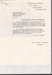
Document - National Trust Collection: Properties 30-45 Mundy Street Bendigo, 1984
... History House 11 Mackenzie Street Bendigo goldfields Social history, Historic buildings 38-42 Mundy Street National Trust Collection: 3230 twin terrace 38-42 Mundy Street, Bendigo 3230 a Letter, 21st August 1984, from the National Trust to Bendigo City Council; strongly urging the Council to retain and refurbish as it is an important part of our heritage and architectural. The twin terraces has a Dutch façade to the street and is the only example from late Victorian ...Social history, Historic buildings National Trust Collection: 3230 twin terrace 38-42 Mundy Street, Bendigo 3230 a Letter, 21st August 1984, from the National Trust to Bendigo City Council; strongly urging the Council to retain and refurbish as it is an important part of our heritage and architectural. The twin terraces has a Dutch façade to the street and is the only example from late Victorian era. 3030 b short article from Bendigo, showing twin terraces and abutting residence from Advertiser, dated 19 July 1984 3030 c City of Bendigo reply, dated 22nd August 1984 - Council has no plans to demolish the buildings 3230 d letter from National Trust again addressing confirmation from Council tat thee are no proposed plans to demolish the twin terrace and abutting weatherboard house 3230 e Bendigo Advertise article and photograph of the two-storey twin terraces at 38-42 Mundy Street 3230 f report on dwellings at 38-42 Mundy Street Bendigo, compiled by M. Butcher; four pages with B&W photos of the buildings 3230 g report compiled by Peter Cuffley over two pages - Report on Mundy Street Terrace pair38-42 mundy street -
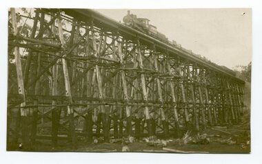 Orbost & District Historical Society
black and white photograph, 1977?
... Historic Sites. Built of red ironbark and grey box timber, it is a fine example of the early engineering skills that utilised the resources and materials found on site. The Bairnsdale to Orbost rail line contains the most varied range of timber & timber composite bridges on any Victorian line. The Stoney Creek bridge is listed on the Victorian Heritage Register for its architectural ...In 1977 great efforts were being made to preserve this bridge, the highest trestle bridge in Victoria at Stoney Creek. The Stony Creek Trestle Bridge was built in 1916 when the existing rail line from Melbourne to Bairnsdale was extended to Orbost. This 97km Bairnsdale to Orbost extension through rugged terrain was reputed to have been the most difficult rail project undertaken in Victoria. In service for over 60 years the bridge was damaged by bushfire in 1980, with the last train crossing in 1987. At 247m long and 20m high, it is the largest standing bridge of its kind in the State, and is listed on the Register of Historic Sites. Built of red ironbark and grey box timber, it is a fine example of the early engineering skills that utilised the resources and materials found on site.The Bairnsdale to Orbost rail line contains the most varied range of timber & timber composite bridges on any Victorian line. The Stoney Creek bridge is listed on the Victorian Heritage Register for its architectural and historical significance.A black / white photograph of a very large trestle bridge. a steam locomotive, with loaded goods trucks, is on the bridge. stoney-creek trestle-bridge railway east-gippsland-railway -
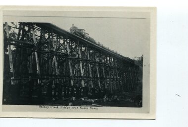 Orbost & District Historical Society
black and white photograph, first half 20th century
... Historic Sites. Built of red ironbark and grey box timber, it is a fine example of the early engineering skills that utilised the resources and materials found on site. The Bairnsdale to Orbost rail line contains the most varied range of timber & timber composite bridges on any Victorian line. The Stoney Creek bridge is listed on the Victorian Heritage Register for its architectural ...The Stony Creek Trestle Bridge was built in 1916 when the existing rail line from Melbourne to Bairnsdale was extended to Orbost. This 97km Bairnsdale to Orbost extension through rugged terrain was reputed to have been the most difficult rail project undertaken in Victoria. In service for over 60 years the bridge was damaged by bushfire in 1980, with the last train crossing in 1987. At 247m long and 20m high, it is the largest standing bridge of its kind in the State, and is listed on the Register of Historic Sites. Built of red ironbark and grey box timber, it is a fine example of the early engineering skills that utilised the resources and materials found on site.The Bairnsdale to Orbost rail line contains the most varied range of timber & timber composite bridges on any Victorian line. The Stoney Creek bridge is listed on the Victorian Heritage Register for its architectural and historical significance. A black / white photograph of a very tall wooden railway bridge with a train along the top.railway-bridge stoney-creek-bridge east-gippsland-railway -
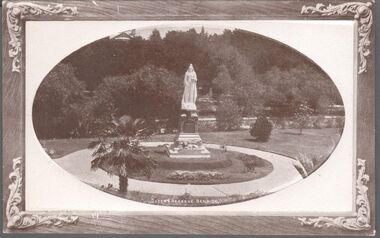 Bendigo Historical Society Inc.
Postcard - BENDIGO POSTCARDS x 5
... Rosalind Park was added to the Victorian Heritage Register in 2000 for its historic, archaeological, aesthetic, scientific (botanical) and architectural significance to the state of Victoria. ...Rosalind Park was added to the Victorian Heritage Register in 2000 for its historic, archaeological, aesthetic, scientific (botanical) and architectural significance to the state of Victoria. ...Five sepia postcards of Bendigo - St. Paul's Church, Bendigo; Queen's Reserve, Bendigo; St. Andrew's Presbyterian Church and School, Bendigo; The Orphanage, Bendigo; and Conservatory Gardens, Bendigo. 'C & L Series' and 'Semco Series', Bendigo. Early 1900's. Unused, and no writing on the reverse of the postcards. May have been connected with the Waterworth family. St. Paul's Church: St Paul's Cathedral, Bendigo was built in stages. The nave was built in 1868, the tower in 1872-73 and the transepts and sanctuary in 1926-27. Robert Love was the architect, although the final stage was supervised by architects Gawler and Drummond. Cathedral status was transferred from the original cathedral All Saints to St Paul's in 1981. The Gothic style cathedral is constructed of red brick with stone dressings. It has a simple cruciform plan comprising a six bay nave, transepts and sanctuary. A tall tower centrally located at the west end dominates the exterior. The peal of eight bells was cast by Meares and Co of London and installed in 1873. The interior features elaborately cusped roof principals; an organ by Alfred Fuller built in 1883 with a console and pipes added later from St Andrew's Cathedral, Sydney; and notable stained glass by Ferguson, Urie and Lyon. St Paul's Rectory was built in 1885 to a design by the architect W C Vahland. The Parish Office and Hall was built as a Sunday School in 1898 to a design by F W Lehmann. Queen's Reserve: Now known as part of the Bendigo Botanic Gardens, Rosalind Park, Pall Mall. In 1851, the gold rush transformed the area and eventually the mullock heaps became the most prominent public park in Bendigo. Rosalind Park was added to the Victorian Heritage Register in 2000 for its historic, archaeological, aesthetic, scientific (botanical) and architectural significance to the state of Victoria. The statue of Queen Victoria dates to 1903. St. Andrew's Presbyterian Church: Opened in 1859 as part of the Presbyterian Church, St. Andrew's. Union of the Presbyterian, Methodist and Congregational Churches in 1977 saw this church join the Uniting Church. Located in Myers Street, Bendigo. The Orphanage: The Convent of the Good Shepherd, Bendigo was established in 1905. It was established at the request of the Bishop to cater for children in the diocese of Bendigo (although it housed children from other areas as well). It was also known as St Aidan’s Orphanage, and was the only Good Shepherd Convent in Australia to care for boys. The section named St Aidan’s accommodated girls aged up to around 16 years, as well as boys aged up to around 11. Maryfields housed girls and women aged from around 15 years. The Convent ceased to operate as a residential facility for children in 1981. A number of women with disabilities remained at the Convent until it closed in 1984. Conservatory Gardens: Now known as part of the Bendigo Botanic Gardens, Rosalind Park, Pall Mall. In 1851, the gold rush transformed the area and eventually the mullock heaps became the most prominent public park in Bendigo. Rosalind Park was added to the Victorian Heritage Register in 2000 for its historic, archaeological, aesthetic, scientific (botanical) and architectural significance to the state of Victoria. The Conservatory Gardens feature an ornate 19th century Conservatory building, erected in 1897 - this was the last building of its type in a public park in Victoria. bendigo, gardens, buildings, chinese, church -
Box Hill Historical Society
Book, Ward, Andrew C, City of Box Hill Heritage and Conservation Study Volume one, 1990
... Box Hill Historical Society Box Hill Heritage Centre Suite 7 Town Hall Hub Box Hill melbourne Heritage and conservation study Land boom Pastoral Inter war years environment Box Hill Combarton Street Surrey Hills Mont Albert Architecture Edwardian Style Victorian style Whitehorse Road Gardens Artists camps Presbyterian Ladies College Kingswood College Hill Street Inter war style This volume explains the Heritage Management Plan and the environmental history detailing it from the Pastoral occupation (1830-1850), the Foundation years (1850s, 1860s), through the Land Boom period and its aftermath (1880s, 1890s) to Reconstruction during the early 1900s and the Inter war years (1920s, 1930s). It also gives a description of specific historic ...This volume explains the Heritage Management Plan and the environmental history detailing it from the Pastoral occupation (1830-1850), the Foundation years (1850s, 1860s), through the Land Boom period and its aftermath (1880s, 1890s) to Reconstruction during the early 1900s and the Inter war years (1920s, 1930s). It also gives a description of specific historic areas including Whitehorse Road Precinct, Box Hill Gardens, Box Hill Cemetery, Surrey Park, Surrey Drive, Box Hill Brickworks, Combarton Street, The Artists' camp, Presbyterian Ladies College, Kingswood College, Garden at 19 Hill Street, Surrey Hills and Mont Albert. Photos. maps. illus.heritage and conservation study, land boom, pastoral, inter war years, environment, box hill, combarton street, surrey hills, mont albert, architecture, edwardian style, victorian style, whitehorse road, gardens, artists camps, presbyterian ladies college, kingswood college, hill street, inter war style -
Box Hill Historical Society
Book, Ward, Andrew C, City of Box Hill Heritage and Conservation Study Volume one, 1990
... Box Hill Historical Society Box Hill Heritage Centre Suite 7 Town Hall Hub Box Hill melbourne Heritage and conservation study Land boom Pastoral Inter war years environment Box Hill Combarton Street Surrey Hills Mont Albert Architecture Edwardian Style Victorian style Whitehorse Road Gardens Artists camps Presbyterian Ladies College Kingswood College Hill Street Inter war style This volume explains the Heritage Management Plan and the environmental history detailing it from the Pastoral occupation (1830-1850), the Foundation years (1850s, 1860s), through the Land Boom period and its aftermath (1880s, 1890s) to Reconstruction during the early 1900s and the Inter war years (1920s, 1930s). It also gives a description of specific historic ...This volume explains the Heritage Management Plan and the environmental history detailing it from the Pastoral occupation (1830-1850), the Foundation years (1850s, 1860s), through the Land Boom period and its aftermath (1880s, 1890s) to Reconstruction during the early 1900s and the Inter war years (1920s, 1930s). It also gives a description of specific historic areas including Whitehorse Road Precinct, Box Hill Gardens, Box Hill Cemetery, Surrey Park, Surrey Drive, Box Hill Brickworks, Combarton Street, The Artists' camp, Presbyterian Ladies College, Kingswood College, Garden at 19 Hill Street, Surrey Hills and Mont Albert. Photos. maps. illus.heritage and conservation study, land boom, pastoral, inter war years, environment, box hill, combarton street, surrey hills, mont albert, architecture, edwardian style, victorian style, whitehorse road, gardens, artists camps, presbyterian ladies college, kingswood college, hill street, inter war style -
Lakes Entrance Historical Society
Book, Historic Buildings Council Victoria, Historic Buildings Council Register 1993, 1993
... Lakes Entrance Historical Society 4 Marine Parade Lakes Entrance gippsland Architecture Heritage A listing of Victorian buildings on the Historic Buildings Council Register at 1993. ...A listing of Victorian buildings on the Historic Buildings Council Register at 1993. Town and Shire locations listed alphabetically. Feature articles included for some buildings.architecture, heritage -
Lakes Entrance Historical Society
Book, Historic Buildings Council, Victoria, Victorian Heritage Register, 1995
... Lakes Entrance Historical Society 4 Marine Parade Lakes Entrance gippsland Heritage Shipwrecks Architecture A register of historic buildings, sites and shipwrecks in Victoria drawn from information available at 26 June 1995, supplied by Historic Buildings Council and Maritime Heritage unit of Heritage Victoria. This is now the province of the Heritage Council, Victoria Victorian ...A register of historic buildings, sites and shipwrecks in Victoria drawn from information available at 26 June 1995, supplied by Historic Buildings Council and Maritime Heritage unit of Heritage Victoria. This is now the province of the Heritage Council, Victoriaheritage, shipwrecks, architecture
