Showing 28 items matching "holloway family"
-
 Rutherglen Historical Society
Photograph - Image, c1890
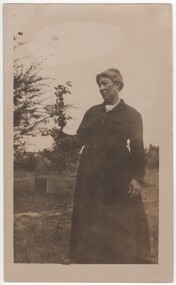
... ...holloway family... orchard and farm belonging to relatives being the Mills and Holloway families. The orchard was south of Barnawartha. ... orchard and farm belonging to relatives being the Mills and Holloway families. The orchard was south of Barnawartha. hooke family holloway family margaret holloway margaret hooke Written on back: "Mrs Hooke nee Holloway" Photograph of Mrs Hooke (nee Holloway) in an orchard. ...Margaret Ellen Holloway was born in 1864 at Indigo via Rutherglen. She married William Hugh Hooke in 1892. Their children were : Allan b 1893, Ida Mary b 1895, Normal b 1896 KIA 1916 WW1, Maxwell b 1902 and Violet b 1904. The orchard that Margaret is photographed in is the family orchard and farm belonging to relatives being the Mills and Holloway families. The orchard was south of Barnawartha. Photograph of Mrs Hooke (nee Holloway) in an orchard.Written on back: "Mrs Hooke nee Holloway"hooke family, holloway family, margaret holloway, margaret hooke -
 Rutherglen Historical Society
Photograph - Image, Artophot, 1920s (Approximate)
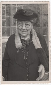
... ...holloway family...Holloway and Mary Bennett. She was born in 1864 in Indigo,via Rutherglen at the gold lead. Her father James came out from Somerset England with a large family group to settle in the North East of Victoria and to try their fortune at gold mining. ...The Holloway’s and their descendants then went on to farm in the district including Rutherglen, Chiltern, Springhurst, Barnawartha and Browns Plains. hooke family holloway family margaret holloway Black and white portrait photograph of Mrs Hooke nee Margaret Ellen Holloway Photograph Image Artophot ...Margaret Ellen Holloway married William Hugh Hooke in 1892. Margaret is the daughter of James Charles Holloway and Mary Bennett. She was born in 1864 in Indigo,via Rutherglen at the gold lead. Her father James came out from Somerset England with a large family group to settle in the North East of Victoria and to try their fortune at gold mining. The Holloway’s and their descendants then went on to farm in the district including Rutherglen, Chiltern, Springhurst, Barnawartha and Browns Plains. Black and white portrait photograph of Mrs Hooke nee Margaret Ellen Hollowayhooke family, holloway family, margaret holloway -
 Rutherglen Historical Society
Postcard - Image, The Empress Studio, c1890
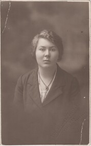
... ...holloway family...Holloway Hooke and William Hooke. Violet was born in 1904 at Chiltern. She was the youngest of the five Hooke children. hooke family holloway family violet hooke Written on back: "Violet" Portrait photograph, on a postcard, of Violet Hooke Postcard Image The Empress Studio ...This is Violet Hooke, daughter of Margaret Holloway Hooke and William Hooke. Violet was born in 1904 at Chiltern. She was the youngest of the five Hooke children. Portrait photograph, on a postcard, of Violet HookeWritten on back: "Violet"hooke family, holloway family, violet hooke -
 Rutherglen Historical Society
Postcard - Image, A. Veney & Co, 1914-1916
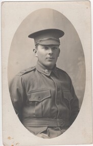
... ...holloway family...Holloway). He was born in 1896 at Rutherglen, enlisted on 11th August 1915, and was killed in action in France on 2nd September 1916. His occupation before enlistment was listed as coach painter. world war 1 world war i hooke family holloway family Written on back: "Norman" Oval photograph, printed on a postcard, of Norman Robert Hooke in his AIF uniform Postcard Image A. ...This photograph has been identified as PTE Norman Hooke (Service No. 3764), son of William Hugh Hooke and Margaret Ellen Hooke (nee Holloway). He was born in 1896 at Rutherglen, enlisted on 11th August 1915, and was killed in action in France on 2nd September 1916. His occupation before enlistment was listed as coach painter.Oval photograph, printed on a postcard, of Norman Robert Hooke in his AIF uniformWritten on back: "Norman"world war 1, world war i, hooke family, holloway family -
 Rutherglen Historical Society
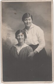
Postcard - Image, Vine's Studios, c1918
... ...holloway family...Ida was 9 years older than Violet, who was the youngest of the Hooke family. They are Holloway descendants. The girls grew up around the Rutherglen, Chiltern and Rutherglen areas. ...Ida was 9 years older than Violet, who was the youngest of the Hooke family. They are Holloway descendants. The girls grew up around the Rutherglen, Chiltern and Rutherglen areas. hooke family holloway family ida hooke violet hooke Written on back: "Ida standing up" Black and white photograph, printed on a postcard, of Violet Hooke (seated) and Ida Hooke (standing) Postcard Image Vine's Studios ...This is Ida Mary Hooke and her younger sister Violet Hooke. Ida was 9 years older than Violet, who was the youngest of the Hooke family. They are Holloway descendants. The girls grew up around the Rutherglen, Chiltern and Rutherglen areas. Black and white photograph, printed on a postcard, of Violet Hooke (seated) and Ida Hooke (standing)Written on back: "Ida standing up"hooke family, holloway family, ida hooke, violet hooke -
 Rutherglen Historical Society
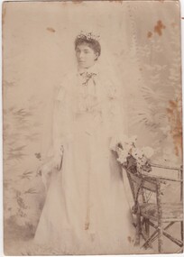
Photograph - Image, 1897
... ...holloway family...This is her in her wedding finery. alice holloway arthur brooke alice brooke brooke family holloway family Written on back: "Dec. | Auntie Alice nee Holloway (Mrs Arthur Brookes, 11 Spencer St., St Kilda | Great Grandfather's brother and sister" Photograph of Mrs Arthur Brooke (nee Alice Holloway). ...Alice Amelia Holloway married Arthur William Brooke in 1897 in Melbourne, Victoria. Alice was 25 years old at the time of her marriage. Alice died in 1959 in St. Kilda, Victoria. Her parents were James Charles Holloway and Mary Martha Bennett. Alice was born at Indigo via Rutherglen in 1872. This is her in her wedding finery. Photograph of Mrs Arthur Brooke (nee Alice Holloway). Confirmed as her wedding photograph.Written on back: "Dec. | Auntie Alice nee Holloway (Mrs Arthur Brookes, 11 Spencer St., St Kilda | Great Grandfather's brother and sister"alice holloway, arthur brooke, alice brooke, brooke family, holloway family -
 Stawell Historical Society Inc
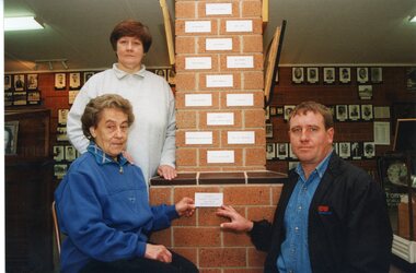
Photograph, Family of the Late Rob Holloway & the Plaque at Stawell Athletic Club
... Family of the Late Rob Holloway & the Plaque at Stawell Athletic Club...Holloway – Family of the Late Rob - Plaque at SAC...Stawell Historical Society Inc 46 Longfield St Stawell grampians Holloway – Family of the Late Rob - Plaque at SAC Stawell Family of the Late Rob Holloway & the Plaque at Stawell Athletic Club Photograph ...Holloway – Family of the Late Rob - Plaque at SACstawell -
 Stawell Historical Society Inc
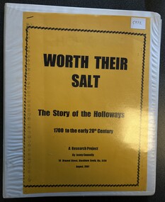
Book - Family History, Jenny Connelly, Worth Their Salt HOLLOWAYS, August 2001
... A Reasearch project by Jenny Connelly of the Holloway family...A Reasearch project by Jenny Connelly of the Holloway family Worth Their Salt The story of the Holloways 1700 - the 20th Century. ...A Reasearch project by Jenny Connelly of the Holloway familyWhite 4 ring Ring BinderWorth Their Salt The story of the Holloways 1700 - the 20th Century. A Research Project By Jenny Connelly -
 Clunes Museum
Booklet, THOMAS HOLLOWAY, HOLLOWAYS ALMANAC & FAMILY FRIEND 1899, 1899
... .1 32 PAGE SOFT COVER BOOKLET. HOLLOWAY ALMANAC & FAMILY FRIEND 1899 COLONIAL EDITION. ...Clunes Museum 36 Fraser Street enter building through Collins Place Clunes goldfields MEDICAL ADVICE AND SPORTS INFORMATION HOUSEWIVES MEDICAL INFORMATION QUEEN MARY KING GEORGE V .1 STAMP ON FRONT COVER - PRESENTED BY JOHN PATIENCE, ALBERT STREET, CLUNES .1 32 PAGE SOFT COVER BOOKLET. HOLLOWAY ALMANAC & FAMILY FRIEND 1899 COLONIAL EDITION. ...MEDICAL ADVICE AND SPORTS INFORMATION.1 32 PAGE SOFT COVER BOOKLET. HOLLOWAY ALMANAC & FAMILY FRIEND 1899 COLONIAL EDITION. HIGHLIGHTING PASTIMES AND GAMES OF MANY NATIONS AND ADVERTISING HOLLOWAY'S PILLS AND OINTMENT AS WELL AS PROVIDING A MEDICAL GUIDE FOR VARIOUS AILMENTS. FRONT & BACK COVER AND INSIDE COVERS PRINTED IN BLUE INK. .2 FULL COLOUR PHOTO CARD/BOOKMARK - HER MAJESTY QUEEN MARY WITH BIRTH, MARRIAGE, ASCENSION AND CORONATION DATES ADVERTISING HOLLOWAYS OINTMENT ON THE BACK. .3 FULL COLOUR PHOTO CARD/BOOKMARK - HIS MAJESTY KING GEORGE V WITH BIRTH, MARRIAGE, ASCENSION AND CORONATION DATES ADVERTISING HOLLOWAYS OINTMENT ON THE BACK..1 STAMP ON FRONT COVER - PRESENTED BY JOHN PATIENCE, ALBERT STREET, CLUNEShousewives, medical information, queen mary, king george v -
 Wodonga & District Historical Society Inc
Photograph - Holloways Building Supplies
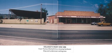
... The next generation of the Holloway family became involved. A Hyster forklift was purchased which allowed for bulk handling of the timber. ...The next generation of the Holloway family became involved. A Hyster forklift was purchased which allowed for bulk handling of the timber. ...Eric Holloway began spot milling timber at age of 17. He borrowed fifty pound from an uncle in 1934 to purchase a McCormick Deering tractor and saw bench. He went from farm to farm cutting timber for farmers. For a time, he worked on Shelley Station spot milling with WS Walker and Son. In approximately 1946 Arthur and Eric Holloway established a saw mill at Shelley. Another brother Ernie, a builder and returned soldier, worked with them from time to time. Using timber sawn in the mill he built eight basic houses for the mill workers. The brothers employed many migrants: - Yugoslav, Czechs, Russians, Ukrainians, Serbs as well as other hardworking people. This meant there were families, so Ernie also built and furnished a school at Shelley. Application was made for a teacher from the Education Department. At the Shelley mill the workers used ex-army blitzes, GM trucks (for carting logs) army ducks and a centurion tank for parts. The timber from the mill was trucked to Albury and Wodonga, customers being FA Stowe and Mates Timber. The army was also a big customer with Holloways supplying timber for the army huts that were built at Bandiana. A timber mill that had been built at Tallangatta by State Rivers and Water for the purpose of establishing New Tallangatta, was purchased by Holloway Brothers as an extension of their Shelley operation. In 1954 a new mill was built at Granite Flat on the Omeo Highway and the Shelley operation closed. Ernie Holloway was involved in the building of the mill and accommodation houses in Mitta Mitta. The mill workers travelled from Mitta to work each day. Holloways Building Supplies was established at 49 Tallangatta Rd Wodonga at this time. It was established on four house blocks with a little shed, with more land being acquired as the operation expanded. The brothers realized that it would be more profitable to set up their own timber outlet to supply their customers. Arthur Holloway continued to run the sawmills while Eric Holloway concentrated on the Wodonga business. A hardware store, offices and joinery were built as demand continued for building materials. All the timber arriving in the yard from the mill was hand sorted, providing employment for many. With the milling and timber outlets Holloways provided employment for approximately forty staff. The next generation of the Holloway family became involved. A Hyster forklift was purchased which allowed for bulk handling of the timber. Land was purchased in Sanyo Drive where timber was cleated and dried. Select grade timber, F17 dry framing, builders hardware and tools were sold. Holloways endeavoured to be a one stop shop for framing and fitting out of houses. In 1989 the business was sold to Mt Beauty Timbers who later on sold to Dahlsens. The timber mill was decommissioned. The Holloway family retained the ownership of the premises of 49 Thomas Mitchell Drive leasing to Dahlsens until that operation was moved to Albury in 2013. In 2014 the lease land was sold to two local businesses. Leigh Martin Marine purchased the parcel of land adjoining their business. Lester and Son purchased the remaining block and demolished the premises. A funeral parlour was built on that site.These photos are significant because they document the story of an important Wodonga business.A series of coloured photographs depicting aspects of Holloways Building Supplies business in Wodonga.holloways wodonga, wodonga businesses, timber industry -
 Eltham District Historical Society Inc
Photograph - Digital Photograph, Alan King, Alistair Knox Park, Eltham, 2008
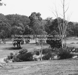
... One of the earliest owners was John Hicks Petty, who in 1874 bought a plot from Holloway. Other families who owned properties in that area, included Rees, Clark, Waterfall, Graham, Hill and Morant. ...One of the earliest owners was John Hicks Petty, who in 1874 bought a plot from Holloway. Other families who owned properties in that area, included Rees, Clark, Waterfall, Graham, Hill and Morant. ...Alistair Knox Park, an oasis of peace and beauty. Covered under National Trust of Australia (Victoria) Landscape Significance and Heritage Overlay, Nillumbik Planning Scheme. Published: Nillumbik Now and Then / Marguerite Marshall 2008; photographs Alan King with Marguerite Marshall.; p173 It is hard to imagine that the Alistair Knox Park, an oasis of peace and beauty beside busy Main Road, Eltham, was once the township’s rubbish dump. It was only in the 1970s that the tip was transformed into this beautiful six hectare space, which later earned it a National Trust Landscape classification. Before its life as a dump, the area was used for small farms. Thanks largely to the foresight and efforts of local environmental builder Alistair Knox, the park was designed sympathetically with the character of the wider Eltham landscape. Then, appropriately, the park was named after Knox, who was an Eltham Shire Councillor from 1971 to 1975 and Shire President in 1975. The park designers were four major forces in the urban bush landscape garden –Knox, landscape designer Gordon Ford, artist Peter Glass and landscaper Ivan Stranger. The National Trust citation for the park, originally called Eltham Town Park, includes the Eltham railway trestle bridge and the Shillinglaw Cottage. The citation states ‘the semi-natural setting of the parkland provides a landscape which is evocative of the history of the area’. Manna Gums (Eucalyptus viminalis) and Candlebarks (Eucalyptus rubida) are significant features. Most of the park’s construction was directed by Bob Grant, Superintendent of the Parks and Gardens Department for the Eltham Shire Council. First plantings occurred in Arbour Week in 1973, then the lake and botanic area were completed in 1975, with Federal Government funding, and the toilet block in 1978. Bounded by the Eltham railway line, Panther Place, Main Road, Bridge and Susan Streets, the park is in a valley about a kilometre wide overlooked by steep hills at the east and west. The Diamond Creek flows through it and the picturesque historic timber trestle railway bridge edges the north. Informal plantings of Australian indigenous and native species in open and undulating grassed settings blend with the natural landscape of the Diamond Creek to the west. The bush-style plants, particularly around the creek, balance with open lawns, paths and a cascade flowing from a small lake to another below. A footbridge over the creek leads to the park’s west. The park includes an adventure playground and barbecue areas. The park stands on part of the land bought from the Crown in 1851 by Josiah Holloway, who subdivided it into allotments and which he called Little Eltham. Most of the land was subdivided into residential lots, but the creek valley, on which the park stands, was subdivided into farm-size lots, used mainly for orchards and grazing. One of the earliest owners was John Hicks Petty, who in 1874 bought a plot from Holloway. Other families who owned properties in that area, included Rees, Clark, Waterfall, Graham, Hill and Morant. In 1901 the railway was built through the area. Jock Read, an Eltham resident since around 1920, remembers several farms in the 1920s and ’30s that occupied the site of today’s park. A poultry farm, which extended from present day Panther Place, was owned by the Gahan family. Next to that farm was another for grazing cattle owned by Jack Carrucan. Beside this was land owned by John Lyon. A doctor lived beside this, and at the north-west corner of Bridge Street and Main Road stood a memorial to the soldiers who died in World War One, which was later moved to the RSL site. Mr Read also remembers other farms and orchards west of the creek In the early 1960s the Eltham Council began buying these farms and in the late 1960s turned the areas east of the Diamond Creek into a garbage tip. When this was filled above the creek’s flood plain, the tip was moved to the west of the creek.This collection of almost 130 photos about places and people within the Shire of Nillumbik, an urban and rural municipality in Melbourne's north, contributes to an understanding of the history of the Shire. Published in 2008 immediately prior to the Black Saturday bushfires of February 7, 2009, it documents sites that were impacted, and in some cases destroyed by the fires. It includes photographs taken especially for the publication, creating a unique time capsule representing the Shire in the early 21st century. It remains the most recent comprehenesive publication devoted to the Shire's history connecting local residents to the past. nillumbik now and then (marshall-king) collection, alistair knox park, eltham -
 Emerald Museum & Nobelius Heritage Park
B/W Photograph, Empire Day 1930, 1930
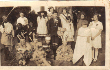
... The rear of the photograph is highly informative about families resident in the district at the time. empire day sherriff a'vard Rear: very faint, under darker overwriting: "Empire Day Celebrations 1930" Darker: "G A'Vard Emerald Concert Preparations 1930" "Back ?J Fulford?? Moyra Sherriff Alma MacKeller F Kennedy Edith A'Vard Molly Young Elsie Scott Thelma Holloway ...The photo was taken on Empire Day 1930, which was then celebrated on 24 May. The assorted fancy dress probably represents the various countries belonging to the British Empire. One girl (wearing the stovepipe hat?) has the same surname as the donor, presumably the donor's daughter. The information regarding the identities of the other children is therefore trustworthy.The photograph shows how Empire Day was celebrated and by implication how it was understood. The rear of the photograph is highly informative about families resident in the district at the time. B/W Photograph of a group of 17 schoolchildren in various kinds of fancy dress. Includes: American Indians, "pilgrim father"(?), blackened faces. A girl in the centre is holding a Union Jack.Rear: very faint, under darker overwriting: "Empire Day Celebrations 1930" Darker: "G A'Vard Emerald Concert Preparations 1930" "Back ?J Fulford?? Moyra Sherriff Alma MacKeller F Kennedy Edith A'Vard Molly Young Elsie Scott Thelma Holloway "Front Vic Fyffe Ron Stuart George Hail Rory Nichols standing Les Cook Front Des Gleeson?" Stamped number "604" empire day, sherriff, a'vard -
 Eltham District Historical Society Inc
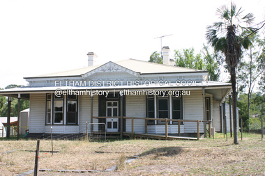
Photograph - Digital Photograph, Jim Connor, Edendale Farm Homestead, 11 December 2014
... Holloway's Little Eltham subdivision. Despite clearing the land, Stooke did not build on this property, choosing to live on his property "Rosehill" at Lower Plenty. In 1896 Thomas Cool, Club Manager of the Victoria Coffee Palace in Melbourne purchased 7 acres of the original Stooke land and built the house now known as Edendale. Cool did not farm the land, instead using it as a gentleman’s residence, retiring to Eltham at weekends. In 1918 he purchased an additional 7 acres but in 1919 he sold the property. Later owners included J.W. Cox, the Gaston family...Holloway's Little Eltham subdivision. Despite clearing the land, Stooke did not build on this property, choosing to live on his property "Rosehill" at Lower Plenty. In 1896 Thomas Cool, Club Manager of the Victoria Coffee Palace in Melbourne purchased 7 acres of the original Stooke land and built the house now known as Edendale. Cool did not farm the land, instead using it as a gentleman’s residence, retiring to Eltham at weekends. In 1918 he purchased an additional 7 acres but in 1919 he sold the property. Later owners included J.W. Cox, the Gaston family ...Edendale Farm is Nillumbik Shire Council's environment centre situated in Gastons Road, Eltham between the railway and the Diamond Creek. The homestead on the property was built in 1896 and is of historical significance, being the subject of a Heritage Overlay under the Nillumbik Planning Scheme. The Edendale property was originally part of an extensive land purchase in 1852 from the Crown by pioneer Eltham farmer Henry Stooke. He initially purchased 51 acres and later expanded his holdings by purchasing another three adjacent Crown allotments extending northerly from Josiah Holloway's Little Eltham subdivision. Despite clearing the land, Stooke did not build on this property, choosing to live on his property "Rosehill" at Lower Plenty. In 1896 Thomas Cool, Club Manager of the Victoria Coffee Palace in Melbourne purchased 7 acres of the original Stooke land and built the house now known as Edendale. Cool did not farm the land, instead using it as a gentleman’s residence, retiring to Eltham at weekends. In 1918 he purchased an additional 7 acres but in 1919 he sold the property. Later owners included J.W. Cox, the Gaston family and D. Mummery. In the 1980s the Eltham Shire Council purchased the site for use as a Council depot, but this use did not proceed. Subsequently, it was used as the Council pound. The Edendale Farm Pet Education and Retention Centre was established in the summer of 1988/1989 and was set up to replace the existing dog kennels with a high standard pet retention centre. The design style of the building was established to compliment the features of the existing house. It was equipped with 10 retention pens, a veterinary room and a pet education area where school children and other interested parties learnt about pet care procedures. It was later developed into a community farm and was run by an advisory committee and in 2000 it became an Environment Centre. In early 2006 an advisory committee was established for the development of a master plan for future development at Edendale Farm. The committee included Russell Yeoman, a former long-time shire planner and founding member of the Eltham District Historical Society. At the time of filming the Master Plan and future for Edendale was about continuing to develop Edendale as a centre of environment learning and looking at expanding displays and school program, running a lot more of life-long learning and workshops around sustainable living.jim connor collection, edendale community farm, edendale farm, eltham, gastons road -
 Eltham District Historical Society Inc
Film - Video (DVD), Nillumbik Shire Council, Edendale Farm Community Environment Centre: History, c.2009
... Holloway's Little Eltham subdivision. Despite clearing the land, Stooke did not build on this property, choosing to live on his property "Rosehill" at Lower Plenty. In 1896 Thomas Cool, Club Manager of the Victoria Coffee Palace in Melbourne purchased 7 acres of the original Stooke land and built the house now known as Edendale. Cool did not farm the land, instead using it as a gentleman’s residence, retiring to Eltham at weekends. In 1918 he purchased an additional 7 acres but in 1919 he sold the property. Later owners included J.W. Cox, the Gaston family...Holloway's Little Eltham subdivision. Despite clearing the land, Stooke did not build on this property, choosing to live on his property "Rosehill" at Lower Plenty. In 1896 Thomas Cool, Club Manager of the Victoria Coffee Palace in Melbourne purchased 7 acres of the original Stooke land and built the house now known as Edendale. Cool did not farm the land, instead using it as a gentleman’s residence, retiring to Eltham at weekends. In 1918 he purchased an additional 7 acres but in 1919 he sold the property. Later owners included J.W. Cox, the Gaston family ...EDENDALE FARM Edendale Farm is Nillumbik Shire Council's environment centre situated in Gastons Road, Eltham between the railway and the Diamond Creek. The homestead on the property was built in 1896 and is of historical significance, being the subject of a Heritage Overlay under the Nillumbik Planning Scheme. The Edendale property was originally part of an extensive land purchase in 1852 from the Crown by pioneer Eltham farmer Henry Stooke. He initially purchased 51 acres and later expanded his holdings by purchasing another three adjacent Crown allotments extending northerly from Josiah Holloway's Little Eltham subdivision. Despite clearing the land, Stooke did not build on this property, choosing to live on his property "Rosehill" at Lower Plenty. In 1896 Thomas Cool, Club Manager of the Victoria Coffee Palace in Melbourne purchased 7 acres of the original Stooke land and built the house now known as Edendale. Cool did not farm the land, instead using it as a gentleman’s residence, retiring to Eltham at weekends. In 1918 he purchased an additional 7 acres but in 1919 he sold the property. Later owners included J.W. Cox, the Gaston family and D. Mummery. In the 1980s the Eltham Shire Council purchased the site for use as a Council depot, but this use did not proceed. Subsequently, it was used as the Council pound. The Edendale Farm Pet Education and Retention Centre was established in the summer of 1988/1989 and was set up to replace the existing dog kennels with a high standard pet retention centre. The design style of the building was established to compliment the features of the existing house. It was equipped with 10 retention pens, a veterinary room and a pet education area where school children and other interested parties learnt about pet care procedures. It was later developed into a community farm and was run by an advisory committee and in 2000 it became an Environment Centre. In early 2006 an advisory committee was established for the development of a master plan for future development at Edendale Farm. The committee included Russell Yeoman, a former long-time shire planner and founding member of the Eltham District Historical Society. At the time of filming the Master Plan and future for Edendale was about continuing to develop Edendale as a centre of environment learning and looking at expanding displays and school program, running a lot more of life-long learning and workshops around sustainable living.edendale community farm, eltham, gastons homestead, gastons road, shire of nillumbik, video recording -
 Eltham District Historical Society Inc
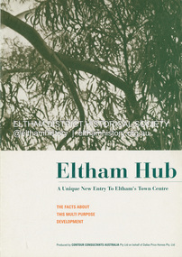
Document - Sales Brochure, Dallas Price Homes Pty Ltd, Eltham Hub: A Unique New Entry To Eltham's Town Centre; the facts about this multi purpose development, 1996
... This land, which contained the Shillinglaw Cottage (c1878-80), was the remaining section of the Shillinglaw family holding that originally comprised 30 acres, being Lot 90 of Holloway's 1851 subdivision. ...This land, which contained the Shillinglaw Cottage (c1878-80), was the remaining section of the Shillinglaw family holding that originally comprised 30 acres, being Lot 90 of Holloway's 1851 subdivision. ...Produced by Contour Consultants Australia Pty Ltd on behalf of Dallas Price Homes Pty Ltd as part of the planning process for redevelopment of the former Eltham Shire Office site at 895 Main Road. In 1963 the Shire of Eltham purchased the Shillinglaw property of approximately 2 acres in Main Road, Eltham for the widening of Main Road and as a site for new Council offices. This land, which contained the Shillinglaw Cottage (c1878-80), was the remaining section of the Shillinglaw family holding that originally comprised 30 acres, being Lot 90 of Holloway's 1851 subdivision. Eltham Council intended to demolish this cottage, but through extensive community action it was saved, funds were raised, and it was relocated to the current site adjacent to the Eltham Library. The new Eltham Shire Offices opened in 1965 were designed to ensure retention of the three Italian Cypress trees that were located outside the Shillinglaw Cottage. In 1971 the building was extended at the southern end to provide additional space, including for the Eltham Library and Council's Engineering Department. Renovations were undertaken to the offices during 1987. The Victorian State Government commenced to restructure local government in 1994, which resulted in the establishment of the Shire of Nillumbik and the cessation of the Shire of Eltham. This new Nillumbik Shire Council was headed by government appointed commissioners, who decided in 1995 to put the former Eltham Shire offices on the market. Eventually in June 1996 the property was sold for $1.1 million and the building was subsequently demolished. A planning application for the site was then submitted to Nillumbik Shire Council in September 1996 for construction of a 24-hour service station, convenience store, cafe/takeaway food premises, a retail facility and community facility. There were many objections to this proposed development and in controversial circumstances a planning permit was granted by the Nillumbik Shire Council commissioners. After protracted actions involving a planning panel and a planning advisory committee, established by the Minister for Local Government, the proposal was eventually rejected as not satisfying the requirements of the planning scheme. In December 1997 the purchaser withdrew from the contract of sale, just prior to Council announcing a withdrawal from the contract. While there have been a number of possible development proposals considered by subsequent Nillumbik Shire Councils, this site has remained vacant since July 1996. TIMELINE (Prepared by Jim Connor, Eltham District Historical Society- March 2018- Based on press, council and personal records) June 1996 - Eltham Shire offices sold to Dallas Price Homes for $1.1 million. July 1996 - Shire office building demolished against community's wishes. Council claimed building riddled with asbestos. September 1996 - Planning application submitted to Nillumbik Shire Council to construct on the site a 24 hours Shell service station, convenience store, Hungry Jacks café/takeaway food premises, a retail facility and community facility. 213 objections and petition of over 1400 signatures received. Minister for Planning and Local Government orders an independent investigation into valuation and sale. 9 October 1996 - Permit granted by Nillumbik Shire Council commissioners, in controversial circumstances. A Planning Special Committee consisting of 3 commissioners and 3 community representatives considered 32 community objections. One commissioner declared a potential conflict of interest so only 2 commissioners were able to vote. After hearing all objections, the community representatives moved a foreshadowed motion to refuse a permit. The commissioners then closed the meeting, formerly opened a council meeting (for about a minute) and approved the application. October 1996 - Community members appealed planning decision to Administrative Appeals Tribunal. November 1996 -Minister for Planning and Local Government Robert McClelland calls appeal in and directs MT to refer this 'major policy issue' to the Governor in Council. February 1997 - Planning panel (Dimity Reed and Margaret Pitt) established to consider submissions. March 1997 - New council elected with five councillors. April 1997 - Three of the five new councillors vote to fight Commissioner's decision to grant a permit. April 1997 - Planning panel (Dimity Reed and Margaret Pitt) conducts hearings at Nillumbik Shire offices. June 1997 -Planning panel rejected Dallas Price Homes proposal as being 'totally inappropriate' for the site and recommends the site be rezoned for 'public purposes'. July 1997 - Dallas Price Homes threatened to sue Council and individual councillors. October 1997 - Report released of an Advisory Committee (Paul Jerome) established by the Minister for Planning and Local Government. Committee considered Dallas Price Homes proposal and an alternative concept plan proposal by Council for a gallery, workshop, offices and cinema community-based development. Advisory Committee recommended Dallas Price Homes proposal be rejected as not satisfying the requirements of the planning scheme and recommended further testing of the financial viability of Council's proposal. December 1997 - Dallas Price Homes withdrew from the contract of sale, just prior to Council announcing a withdrawal from the contract, which expired on 28th November and was not renewed by either side, after previously being extended twice pending a decision by the Minister. Council had to pay developer $58,000 for demolition costs. February 1998 - Dallas Price Homes application rejected by Planning and Local Government Minister. October 1998 - Nillumbik Councillors suspended and an Administrator appointed (until March 1999). The demolition of the former Shire of Eltham offices and proposed sale and development driven by the Commissioners for Nillumbik Shire Council brought the community together in substantial protest at the infrigement of ratepayers democratic say in local government and ciommunity assets combined with protests about inappropraite development of Eltham's Gateway. This issue led to the formation of the Eltham Community Action Group which still operates strongly today (2023) on behalf of the community to ensure appropriate development within the community.895 main road, commissioners, dallas price homes, development application, eltham hub, hungry jacks, nillumbik shire council, re-zoning, shell service station, town planning, eltham gateway, eltham gateway action group, eltham shire offices, shillinglaw cottage, shillinglaw farm, shillinglaw trees, jim connor collection -
 Eltham District Historical Society Inc
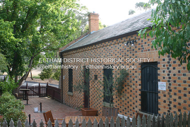
Photograph - Digital Photograph, Alan King, Shillinglaw Cottage, 6 January 2008
... The Shillinglaw family then bought it and lived there for around 80 years until 1963 when they sold it to the Eltham Council.2 Farmer Thomas Cochrane bought the Shillinglaw Cottage site from land developer Josiah Holloway. ...The Shillinglaw family then bought it and lived there for around 80 years until 1963 when they sold it to the Eltham Council.2 Farmer Thomas Cochrane bought the Shillinglaw Cottage site from land developer Josiah Holloway. ...Covered under National Estate, National Trust of Australia (Victoria) Local Significance and Heritage Overlay, Nillumbik Planning Scheme. Published: Nillumbik Now and Then / Marguerite Marshall 2008; photographs Alan King with Marguerite Marshall.; p95 Thanks to an Australia first effort by local residents, the historic Shillinglaw Cottage still survives. The cottage at Panther Place, Eltham, once stood about 100 metres away on Main Road. But in 1963 it faced demolition to make room for the Eltham Shire Offices (since demolished). However residents rallied to save Shillinglaw Cottage and became the first in Australia to remove and reconstruct an early settler’s brick building. A fundraiser was the residents’ compilation of loved recipes into the cookery book, Flavour of Eltham. The cottage, built in the late 1870s by noted pioneer builder George Stebbing, is one of Eltham’s earliest buildings and associated with significant early settlers. It is on the National Estate and National Trust Registers. The cottage was constructed with handmade bricks in the Flemish Bond style, typical of cottages and farmhouses in Flanders, Europe. It features burnt ‘header’ bricks over the façade, which gives a chequered effect. The roof is made of slate, while the windows are 12-paned sash with relieving arches. It is not clear who were the first owners of the cottage. The National Trust claims that Stebbing built it for farmer Thomas Cochrane.1 Others say Cochrane first owned the land but Stebbing was Shillinglaw’s first owner and remained so until 1887. The Shillinglaw family then bought it and lived there for around 80 years until 1963 when they sold it to the Eltham Council.2 Farmer Thomas Cochrane bought the Shillinglaw Cottage site from land developer Josiah Holloway. The site was the largest in what Holloway called Little Eltham, of some 30 acres (12 ha), extending along the creek from Henry Street to Luck Street. In 1874 Cochrane sold the land to George Stebbing. Meanwhile in 1861, Stebbing was the owner and occupier of a house at Pitt Street, Eltham, which he had built. Evelyn Observer journalist James Rossiter rented the Pitt Street house, then in 1881 Phillip Shillinglaw occupied it. Stebbing constructed several buildings of note in the area, including the Uniting Church at John Street, the building beside it – a former bank – and St Margaret’s Church of England in Pitt Street. Stebbing was also an Eltham Shire Councillor from 1871 to 1873 and a trustee and treasurer of the Eltham Wesleyan Church.3 In the 1870s he is recorded as the owner of up to five houses. Earlier he had been described as a bricklayer and later became a farmer. In 1882 Stebbing returned to the Pitt Street house and Shillinglaw occupied the new house in Main Road, which he owned from 1887. Shillinglaw was a prolific poet and preached at the Eltham Primitive Methodist Church, where he also served as Sunday School superintendent and led the Young People’s Society Christian Endeavour. The Shillinglaws saw many changes in their property’s boundaries – the major one occurring at the turn of the century when land for the railway and Eltham station was acquired from their holding. The northern part of the remaining land was then used for some of the first commercial developments in what was to become the Eltham Shopping Centre. Later still, the land immediately north of the cottage was bought by the Eltham War Memorial Trust for the War Memorial Buildings and the fire station. The Trust’s land eventually passed to the council. The council bought the remaining two acres (0.8 ha) with the house, and with the exception of the commercial development between the fire station and the post office, all of the former Shillinglaw land is owned by the council or government instrumentalities.4 Since the late 20th century, the cottage has had varied uses, such as a handcrafts store and as a restaurant.This collection of almost 130 photos about places and people within the Shire of Nillumbik, an urban and rural municipality in Melbourne's north, contributes to an understanding of the history of the Shire. Published in 2008 immediately prior to the Black Saturday bushfires of February 7, 2009, it documents sites that were impacted, and in some cases destroyed by the fires. It includes photographs taken especially for the publication, creating a unique time capsule representing the Shire in the early 21st century. It remains the most recent comprehenesive publication devoted to the Shire's history connecting local residents to the past. nillumbik now and then (marshall-king) collection, shillinglaw cottage -
 Eltham District Historical Society Inc
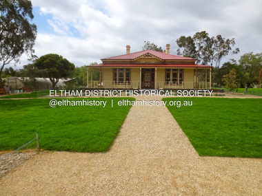
Photograph - Digital Photograph, Alan King, Edendale Farm Homestead, 29 January 2008
... Holloway's Little Eltham subdivision. Despite clearing the land, Stooke did not build on this property, choosing to live on his property "Rosehill" at Lower Plenty. In 1896 Thomas Cool, Club Manager of the Victoria Coffee Palace in Melbourne purchased 7 acres of the original Stooke land and built the house now known as Edendale. Cool did not farm the land, instead using it as a gentleman’s residence, retiring to Eltham at weekends. In 1918 he purchased an additional 7 acres but in 1919 he sold the property. Later owners included J.W. Cox, the Gaston family...Holloway's Little Eltham subdivision. Despite clearing the land, Stooke did not build on this property, choosing to live on his property "Rosehill" at Lower Plenty. In 1896 Thomas Cool, Club Manager of the Victoria Coffee Palace in Melbourne purchased 7 acres of the original Stooke land and built the house now known as Edendale. Cool did not farm the land, instead using it as a gentleman’s residence, retiring to Eltham at weekends. In 1918 he purchased an additional 7 acres but in 1919 he sold the property. Later owners included J.W. Cox, the Gaston family ...Edendale Farm is Nillumbik Shire Council's environment centre situated in Gastons Road, Eltham between the railway and the Diamond Creek. The homestead on the property was built in 1896 and is of historical significance, being the subject of a Heritage Overlay under the Nillumbik Planning Scheme. The Edendale property was originally part of an extensive land purchase in 1852 from the Crown by pioneer Eltham farmer Henry Stooke. He initially purchased 51 acres and later expanded his holdings by purchasing another three adjacent Crown allotments extending northerly from Josiah Holloway's Little Eltham subdivision. Despite clearing the land, Stooke did not build on this property, choosing to live on his property "Rosehill" at Lower Plenty. In 1896 Thomas Cool, Club Manager of the Victoria Coffee Palace in Melbourne purchased 7 acres of the original Stooke land and built the house now known as Edendale. Cool did not farm the land, instead using it as a gentleman’s residence, retiring to Eltham at weekends. In 1918 he purchased an additional 7 acres but in 1919 he sold the property. Later owners included J.W. Cox, the Gaston family and D. Mummery. In the 1980s the Eltham Shire Council purchased the site for use as a Council depot, but this use did not proceed. Subsequently, it was used as the Council pound. The Edendale Farm Pet Education and Retention Centre was established in the summer of 1988/1989 and was set up to replace the existing dog kennels with a high standard pet retention centre. The design style of the building was established to compliment the features of the existing house. It was equipped with 10 retention pens, a veterinary room and a pet education area where school children and other interested parties learnt about pet care procedures. It was later developed into a community farm and was run by an advisory committee and in 2000 it became an Environment Centre. In early 2006 an advisory committee was established for the development of a master plan for future development at Edendale Farm. The committee included Russell Yeoman, a former long-time shire planner and founding member of the Eltham District Historical Society. At the time of filming the Master Plan and future for Edendale was about continuing to develop Edendale as a centre of environment learning and looking at expanding displays and school program, running a lot more of life-long learning and workshops around sustainable living. Covered under Heritage Overlay, Nillumbik Planning Scheme. Published: Nillumbik Now and Then / Marguerite Marshall 2008; photographs Alan King with Marguerite Marshall.; p101 A sharp turn from busy Wattletree Road by the railway line, brings a surprise. Only 1.4 km from Eltham’s centre, sheep feed, blissfully unaware of the hectic suburban activity so close by. At the entrance to the 5.6ha Edendale Farm is another surprise. A work of art that looks like huge tree trunks transformed into bowler and top-hatted men. The Fences Act 1968 by Tony Trembath with Mark Cain and John Doyle, 1996, is classified by the National Trust of Australia as having Regional Significance. The title refers to a government act on disputes between neighbors over the placement of fences and boundaries. This takes a ‘wry swipe’ at a community divided by trivial squabbles. It also celebrates making do with limited resources.1 Further along on the left, the office wall is decorated with a massive Eltham Copper Butterfly, designed by Robert Tickner and made by school children with used plastic bottles and other waste material. Nillumbik Council runs Edendale as an Environmental Education Centre, to help preserve and enhance the local environment. As early as 1988 the former Eltham Shire Council realised Edendale’s importance in meeting people’s needs, particularly of children, to enjoy farmland. The centre, with the Eltham North Reserve to the north - including remnant bushland and open parkland - makes up the major part of the public open space for this area. The council considers this area will become increasingly important to the local community for recreational use.2 Educational programs aim to encourage community involvement to ensure the long-term rehabilitation and protection of natural bushland areas. Edendale is used by people of all ages - from school children to adults - for environmental programs and workshops, as well as for recreation, to enjoy the domestic animals and to picnic. Edendale is also home to the Environmental Works staff who manage reserves and roadsides and support Nillumbik Friends environmental groups. The Friends propagate plants at the nursery, which grows indigenous plants and sells these to the public.3 The centre demonstrates the sustainable living the farm teaches, with features like solar hot water and drive lighting and for the fireplace, logs of recycled cardboard. Edendale has had a varied history as a dog pound and even as a retreat for Thomas Cool, Club Manager of the Victoria Coffee Palace in Melbourne. His single-storey weatherboard house built in 1896, which still stands, was grander than most homes in Eltham. Although such buildings were common in many other parts of Melbourne, Eltham’s poverty and remoteness did not encourage such construction. The Victorian rectangular-shaped house, with a corrugated iron roof and veranda, has elegant large rooms, leadlight windows, ceiling roses, two bay windows and ornately carved wooden fireplace surrounds. Cool bought seven acres (2.8ha) from pioneer Eltham farmer Henry Stooke’s 200 acre (81ha) farm, which he had bought from the Crown in 1852. In 1918 Cool bought an extra seven acres (2.8ha) but in 1919 sold the estate to farmer John Cox. In 1933 Cox sold Edendale to Mrs Elizabeth Gaston, after whom the road leading to the centre was named. The property was owned by several Gaston family members, who called it Edendale, then by a police constable, Douglas Mummery, until the Shire of Eltham bought it in 1970. Oddly Edendale was known as Mummery’s for almost 20 years, although Mummery owned it only for a short time.4 The shire used Edendale as a dog pound until amalgamation with other municipalities in 1996. The pound then moved to the Yan Yean Road, Plenty site, which had been used by the former Diamond Valley Shire Council. To the west and north the centre is bounded by Diamond Creek and on the east by the Melbourne-Hurstbridge railway line. Part of the Research creek forms the centre’s southern boundary.This collection of almost 130 photos about places and people within the Shire of Nillumbik, an urban and rural municipality in Melbourne's north, contributes to an understanding of the history of the Shire. Published in 2008 immediately prior to the Black Saturday bushfires of February 7, 2009, it documents sites that were impacted, and in some cases destroyed by the fires. It includes photographs taken especially for the publication, creating a unique time capsule representing the Shire in the early 21st century. It remains the most recent comprehenesive publication devoted to the Shire's history connecting local residents to the past. nillumbik now and then (marshall-king) collection, edendale farm -
Glen Eira Historical Society
Document - Hengar, Glen Eira Road, 356, Elsternwick
... Holloway J M... Langdon Henry J... Rosecraddock... Beemery Park Estate... Lirrewa... Caulfield Town Hall... Langdon Family...family in 1887/1888. The report includes an explanation of the term dower house, outlines the land sale history since 1851 and gives a brief history of the occupancy of Hengar from 1888 to 1989. The file also includes one page of undated, unattributed handwritten working notes. Landells Rosalind Bullock Hilary Hengar Glen Eira Road Elsternwick Holloway ...A copy of two page typed report by Hilary Bullock and Rosalind Landells, dated 18/01/1990, on the history of Hengar, a dower house built for the Langdon family in 1887/1888. The report includes an explanation of the term dower house, outlines the land sale history since 1851 and gives a brief history of the occupancy of Hengar from 1888 to 1989. The file also includes one page of undated, unattributed handwritten working notes.landells rosalind, bullock hilary, hengar, glen eira road, elsternwick, holloway j m, langdon henry j, rosecraddock, beemery park estate, lirrewa, caulfield town hall, langdon family, deanmead a, griffith alfred, langdon e e, langdon h j, langdon laura, langdon henry, langdon bessie, sadler emily amy, brenton v c, herz s, beth riukan girls’ college, happy days kindergarten, florence herald herbert, happy days child minding, manners and customs, preschools -
 Eltham District Historical Society Inc
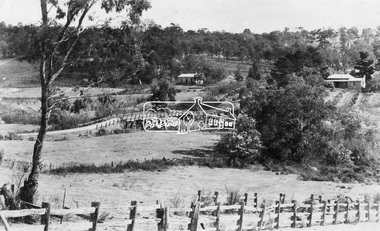
Photograph, View at Eltham, Vic, c.1924
... Holloway in 1851. The land was sub-divided and called "Little Eltham". Bridge Street was created as part of the sub-division. Most of the sub-division was residential lots but the creek valley was divided into lots for small farms. Council started to buy the land for the Eltham Town park in the early 1960s. The area was used as a garbage tip and filled above the flood plain of the creek. Development of the land for a park began in the early 1970s. The house on the right was owned for many years by the Hill family...Holloway in 1851. The land was sub-divided and called "Little Eltham". Bridge Street was created as part of the sub-division. Most of the sub-division was residential lots but the creek valley was divided into lots for small farms. Council started to buy the land for the Eltham Town park in the early 1960s. The area was used as a garbage tip and filled above the flood plain of the creek. Development of the land for a park began in the early 1970s. The house on the right was owned for many years by the Hill family ...Copy of possible Rose Stereograph Co. postcard “View at Eltham, Vic.”, c.1924 looking southwest from Main Road near York Street to Bridge Street and the original 1875 bridge across what is now the Alistair Knox Park The land in the foreground was first bought from the Crown by J.M. Holloway in 1851. The land was sub-divided and called "Little Eltham". Bridge Street was created as part of the sub-division. Most of the sub-division was residential lots but the creek valley was divided into lots for small farms. Council started to buy the land for the Eltham Town park in the early 1960s. The area was used as a garbage tip and filled above the flood plain of the creek. Development of the land for a park began in the early 1970s. The house on the right was owned for many years by the Hill family until Council bought it in the early 1960s. The house was built in the 1850s or 60s. The house on the left stood on what is now the southwest corner of Susan and Bridge Streets. The Braithwaite family was associated with this house. The double line of fencing in the foreground was a continuation of York Street to the creek. The Bridge Street bridge was built in 1875 and replaced in 1958. (Ref: Early view of Little Eltham; Byways of History by Colleen Ison, Publication unk, 24 August 1982) Reproduced on p61 of 'Pioneers & Painters' Date estimated on same as View at Hurstbridge featuring Wattle Valley EstateThis photo forms part of a collection of photographs gathered by the Shire of Eltham for their centenary project book,"Pioneers and Painters: 100 years of the Shire of Eltham" by Alan Marshall (1971). The collection of over 500 images is held in partnership between Eltham District Historical Society and Yarra Plenty Regional Library (Eltham Library) and is now formally known as the 'The Shire of Eltham Pioneers Photograph Collection.' It is significant in being the first community sourced collection representing the places and people of the Shire's first one hundred years.Digital image 120 format B&W negative Prints 17 x 25 cm and 10 x 15 cmsepp, shire of eltham pioneers photograph collection, eltham, bridge street, bridge, alistair knox park, braithwaite, bridge street bridge, eltham town park, hill family home, main road, pioneers and painters, york street -
 Eltham District Historical Society Inc
Slide - Photograph, Eltham Town Park, c.May 1988
... The ownership of one parcel has been traced back to when it was purchased from Holloway by John Hicks Petty in 1874, long after it was subdivided. Other families owning land within the area over the years included Lyon, Rees, Clark, Waterfall, Carrucan, Graham, Hill and Morant. ...The ownership of one parcel has been traced back to when it was purchased from Holloway by John Hicks Petty in 1874, long after it was subdivided. Other families owning land within the area over the years included Lyon, Rees, Clark, Waterfall, Carrucan, Graham, Hill and Morant. ...In 1981 the Shire of Eltham Historical Society was asked by the Victorian Place Names Committee to comment on a proposal by the Shire of Eltham to assign names to parklands in Eltham as follows:- "Eltham Common" - the area between the municipal offices, Main Road, the Eltham railway -line, and Panther Place and containing Shillinglaw Cottage. The Shire has advised that this name has been used locally for the site since about 1975. "Alistair Knox Park" - the area bounded by the Eltham railway -line, Panther Place, Main Road, Bridge Street, and Susan Street, and through which flows the Diamond Creek. The area has been known locally as "Eltham Town Park" The proposed name "Alistair Knox Park" had created some local controversy with a number of reversals of the Council's decision and letters to the local paper both for and against the proposal. The society was reluctant to be drawn into this controversy particularly as there were known to be members with strong views both for and against the proposed name. The society appreciated the work done by Alistair Knox both in the formulation of the park concept and in its development but because of the controversy generated by the proposed naming and also because of the wide general use of the park by the public·, the name Eltham Town Park was felt more appropriate. The society noted that there was no outstanding historical associations with the land comprising the park which would warrant naming the park after any particular person, place or event. No objection was raised to the Eltham Common proposal as set-out above. The decision was made in the knowledge that Alistair Knox had been associated with the society over many years and was a prominent figure in the recent history of Eltham. He was regarded as a key figure in the environmental building movement and in particular was renowned for his use of mud bricks as a building material. He served as a councillor of the Shire of Eltham from 1971-1975, his final year as Shire President. It was during these years that the proposals to create the park in its present form were shaped and Alistair played a leading part in the decision to make it a landscaped passive recreational park rather than a sporting area. The parklands comprise a section of the Diamond Creek valley. The creek itself flows through the centre of the area which is overlooked by steep hills on each side. The parks form part of the land purchased from the Crown in 1851 by J.M. Holloway and then subdivided into allotments and called "Little Eltham". While most of the area was subdivided into residential lots the creek valley was subdivided into lots suitable for small farms. Some further subdivision took place over the years and the whole of the parks now comprises eight separate titles. A list of some of the former owners has been compiled but exhaustive research on all owners has not been carried out. The ownership of one parcel has been traced back to when it was purchased from Holloway by John Hicks Petty in 1874, long after it was subdivided. Other families owning land within the area over the years included Lyon, Rees, Clark, Waterfall, Carrucan, Graham, Hill and Morant. The character of the valley area has remained rural while development occurred on each side. Early photos show the area as orchard and grazing land. In 1901 the railway was constructed through the area resulting in the timber trestle bridge across the Diamond Creek. which is an important feature of the park landscape. A memorial obelisk to the Eltham servicemen killed in World War 1 was erected at the south eastern corner of the park. The site is now within the intersection of Main Road and Bridge Street and the memorial was shifted in the 1950s to the Eltham R.S.L. clubrooms. Following the financial failure of the local sub-branch, the memorial obelisk was again relocated to the Eltham War Memorial building precinct in 2011. During the early 1960's the Council started purchasing the land which now comprises the parks. In the late 1960's the area to the east of the Diamond Creek was used as a garbage tip and filled above the flood plain of the creek. When this area was filled the tip was transferred to the west side of the creek. From the early 1970's the area has been progressively developed as a park for passive recreation with ornamental lakes, extensive tree planting and landscaping. The character of the valley before the days of the tip has been recreated and this has earned a Landscape classification from the National Trust, an unusual honour for a man-made landscape. The parks are not only attractive in appearance. The large number of people using them, particularly at weekends and holidays is evidence of their popularity and the foresight and careful planning of local residents, Councillors and Council Staff. 35mm colour positive transparency (1 of 23) Mount - Kodak EktachromeProcess Date MAY 88Meltham, main road, alistair knox park, eltham town park -
 Bendigo Historical Society Inc.
Photograph - STRAUCH COLLECTION: WENDALL FAMILY
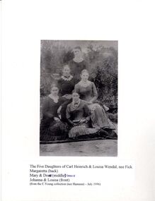
... Holloway in 1897; Margaretta (1868-1944) married Heriot Percy Bedwell in 1897; Louisa ( 1870-1897) married Wilhelm Micheel in 1896. PHOTOGRAPH Person wendal Genealogy-Wendal-German Copy of photograph of the five daughters of Carl Heinrich & Louisa Wendal (nee Fick) Margaretta, Mary, Doris, Johanna & Louisa. From the C.Yeung collection (nee Hamann) July 1996. Photograph STRAUCH COLLECTION: WENDALL FAMILY ...Carl Heinrich Wendal (Wendel, Wendell) (1836-1913) married Louisa Fick 1838-1919) in 1861. They had the following children:- Marie Margarita (1862-1925) m. Thomas Brown in 1890; Johanna (1864-1946) married Carl Hamann in 1887; Doris (1866-1938) married Frank Holloway in 1897; Margaretta (1868-1944) married Heriot Percy Bedwell in 1897; Louisa ( 1870-1897) married Wilhelm Micheel in 1896.Copy of photograph of the five daughters of Carl Heinrich & Louisa Wendal (nee Fick) Margaretta, Mary, Doris, Johanna & Louisa. From the C.Yeung collection (nee Hamann) July 1996.photograph, person, wendal, genealogy-wendal-german -
 City of Moorabbin Historical Society (Operating the Box Cottage Museum)
Photographs,x3 Colour Early Weatherboard Cottage Cheltenham c1880, 1981
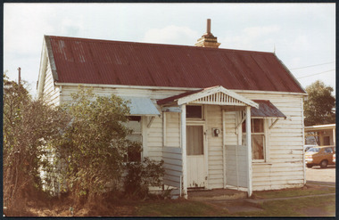
... families. Photo taken 1981 by CMHS member keys robert, holloway josiah, king brothers, smith j l; smith mary ann, stanley helen, chaff cutter, horse drawn carts, toll gates brighton, motor cars 1900, steam engines, early settlers, bentleigh, parish of moorabbin, city of moorabbin, county of bourke, moorabbin roads board, shire of moorabbin, henry dendy's special survey 1841, were j.b.; bent thomas, o'shannassy john, king richard, charman stephen, highett william, ormond francis, maynard dennis, market gardeners, vineyards, orchards Kodak Aug. 81 / Handwritten Pine St Cheltenham 3 x Colour photographs of an early c 1900 weatherboard house in Pine St Cheltenham taken by CMHS member 1981 Photographs,x3 Colour Early Weatherboard Cottage Cheltenham c1880 ...Henry Dendy , a farmer from Sussex England, purchased 5,120 acres of land in the area of a 'Special Survey 1841' that extended from Brighton bayside North Road, East Boundary Rd to South Road. This area became known as Dendy's Brighton and as part of the sale 139 emigrant workers arrived in 1842 however Dendy was unable to find work and lodgings for these people. J.B.Were, financier took over the management of the 'Special Survey 1841' area and began to sell and lease allotments. 1850 the Squatter King brothers sold land south of Dendy's 'Special Survey 1841' to Josiah Holloway who sectioned it into 2 acre lots @ £10 each for market gardens - 'Two Acre Village' and Charles Whorral opened a small hotel - 'The Cheltenham Inn' on the main Road - Arthur's Seat Rd, later Point Nepean Rd, now Nepean Highway. Notable settlers who moved into the area were Keys, Charman, Bruton, Le Page, Fairlam, Meeres and 1862 saw the separation from Brighton and the formation of the Mooorabbin Roads Board District. .By 1879 1000settlers were living in 'Cheltenham' serviced by a Post Office with Bank, Mechanics Institute, State School No 84,Keys Hotel, Meeres Store, Sir Thomas Bent ensured the new Railway Line from Caulfield to Mordialloc went through his constituency of Cheltenham 1881 and this changed the development to the bayside area of Cheltenham away from the 'Two Acre Village ' side causing some dissention, However Cheltenham as whole prospered and this house in Pine St is typical of the cottages built c 1890- 1900 in the area. This weatherboard house c 1890-1900 in Pine St Cheltenham is typical of those built for early settler families. Photo taken 1981 by CMHS member 3 x Colour photographs of an early c 1900 weatherboard house in Pine St Cheltenham taken by CMHS member 1981Kodak Aug. 81 / Handwritten Pine St Cheltenhamkeys robert, holloway josiah, king brothers, smith j l; smith mary ann, stanley helen, chaff cutter, horse drawn carts, toll gates brighton, motor cars 1900, steam engines, early settlers, bentleigh, parish of moorabbin, city of moorabbin, county of bourke, moorabbin roads board, shire of moorabbin, henry dendy's special survey 1841, were j.b.; bent thomas, o'shannassy john, king richard, charman stephen, highett william, ormond francis, maynard dennis, market gardeners, vineyards, orchards -
 City of Moorabbin Historical Society (Operating the Box Cottage Museum)
Photograph, 14th Dec. 1927 Funeral of Cr. F.T. Le Page JP Cheltenham, 14th Dec. 1927 Funeral of Cr. F.T. Le Page JP Cheltenham, 14th December 1927
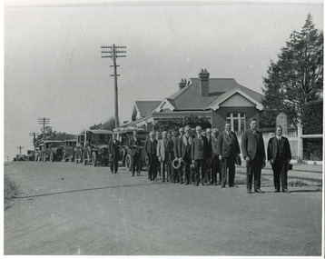
... Holloway's two-acre lots and established a market garden. Frank T Le Page worked on his father's market garden from age 14, then worked as a coachman and met Tommy Bent whilst employed at Brighton Grammar School. He bought land adjacent to his father's , built Daphne Cottage in 1876 and later established the Cheltenham Cream and Butter Factory. Frank T. Le Page was member of many community groups and was a Moorabbin Shire Councillor for 25 years serving a term as President. 'The Le Pages became one of the best known Moorabbin market gardening families ...14th December 1927. The funeral of Cr. F.T. Le Page, leaving Cheltenham Church of Christ, Chesterville Road, for the old Cheltenham Cemetary. The undertakers were W.D. Rose & Son. Standing alongside the hearse is Mr Wally Rose. In front him is Mr Clarrie Judd, father of Mrs Clarice Whitehead. At the front of the procession are two Church of Christ Ministers. On the right is Mr Daniel Wakefield, who was minister at the time. On the left is Mr Mudge who was the previous minister. The man wearing collars are members of the Star of Moorabbin Order, of the Sons of Temperance Friendly Society. Others are elders from the church. Some of the names are: Mr George Brough, Mr Horace Brough, George Roberts, Tom Tilley, and Frank Martin. The house in the photograph was the home of Mr and Mrs Fred. Judd. The picket fence was at the front of the Church and the Cypress hedge on the right, was the home of Mr Chas. Fairbank, now the Church Manse grounds.Frank T Le Page arrived in Cheltenham, ( Two Acre Village) aged 3 with his father Nicholas Le Page , a tailor from Guernsey in the Channel Islands. Nicholas purchased one of Holloway's two-acre lots and established a market garden. Frank T Le Page worked on his father's market garden from age 14, then worked as a coachman and met Tommy Bent whilst employed at Brighton Grammar School. He bought land adjacent to his father's , built Daphne Cottage in 1876 and later established the Cheltenham Cream and Butter Factory. Frank T. Le Page was member of many community groups and was a Moorabbin Shire Councillor for 25 years serving a term as President. 'The Le Pages became one of the best known Moorabbin market gardening families, with a tradition of service to communal and civic affairs that is unmatched.' John Cribbin ' Moorabbin A Pictorial History 1862-1994 ' p3714th December 1927. The funeral of Cr. F.T. Le Page, leaving Cheltenham Church of Christ, Chesterville Road, for the old Cheltenham Cemetary. The undertakers were W.D. Rose & Son. Standing alongside the hearse is Mr Wally Rose. In front him is Mr Clarrie Judd, father of Mrs Clarice Whitehead. At the front of the procession are two Church of Christ Ministers. On the right is Mr Daniel Wakefield, who was minister at the time. On the left is Mr Mudge who was the previous minister. The man wearing collars are memebers of the Star of Moorabbin Order, of the Sons of Temperance Friendly Society. Others are elders from the church. Some of the names are: Mr George Brough, Mr Horace Brough, George Roberts, Tom Tilley, and Frank Martin. The house in the photograph was the home of Mr and Mrs Fred. Judd. The picket fence was at the front of the Church and the Cypress hedge on the right, was the home of Mr Chas. Fairbank, now the Church Manse grounds.Written as above signed D. Maynard 2/4/86funeral, 14th december 1927, cr. f.t. le page, cheltenham cemetery, mr george brough, mr horace brough, george roberts, tom tilley, frank martin., cheltenham church of christ, early settlers, market gardeners, rellgious rites, justice of the peace, star of moorabbin order of the sons of temperance friendly society, daphne cottage cheltenham victoria, cheltenham cream and butter factory ltd, tommy bent, moorabbin shire, le page everest , le page frank w. , le page frank t,, two acre village, dendy's special survay 1841, holloway josiah morris, -
 City of Moorabbin Historical Society (Operating the Box Cottage Museum)
Functional object - Travel Trunk, c 1851 wood, brass lock and hinges and Guernsey Newspaper 1851, c1851
... family when emigrating from Guernsey , Channel Isles, to Melbourne on SS Caliope 1852. Nicholas LePage , a tailor, and wife Elizabeth arrived in Melbourne in 1852 with their son Frank Thomas and daughter Elizabeth. Joshua Holloway...family when emigrating from Guernsey , Channel Isles, to Melbourne on SS Caliope 1852. Nicholas LePage , a tailor, and wife Elizabeth arrived in Melbourne in 1852 with their son Frank Thomas and daughter Elizabeth. Joshua Holloway ...This wood traveling trunk was used by the LePage family when emigrating from Guernsey , Channel Isles, to Melbourne on SS Caliope 1852. Nicholas LePage , a tailor, and wife Elizabeth arrived in Melbourne in 1852 with their son Frank Thomas and daughter Elizabeth. Joshua Holloway released land in his 'Two Acre Village' in Cheltenham 1851. Nicholas bought a LOT for 10pounds and began a market garden that was managed by successive generations. The LePage family became involved with the Methodist Church , local friendly societies, sporting clubs and civic councils that endured. 'The LePages became one of the best known Moorabbin market gardening families, with a tradition of service to communal and civic affairs that is unmatched' John Cribbin, ' Moorabbin ,Pictorial History 1862-1994.' (City of Kingston)A handmade wood trunk with brass lock and hinges and Guernsey ( Channel Isles) Newspaper lining 1851Top of lid; White Stencil BETSEY LEPAGE / PASSENGER TO MELBOURNE Lining of box; Guernsey Newspaper 1851 henry dendy's special survey 1842, moorabbin shire, moorabbin roads board, dendy henry, were jb, holloway josiah, brighton, bentleigh, cheltenham, pioneers, market gardeners, early settlers, methodist church, two acre village cheltenham, charman stephen, bent thomas, daphne cottage, sons of temperance friendly society, mayors moorabbin council, lepage nicholas, lepage frank thomas, lepage everest, lepage frank wilbur, cheltenham co-operative society, cheltenham cream and butter factory -
 Greensborough Historical Society
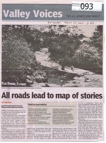
Newspaper - Newspaper clipping, All roads lead to map of stories, 27/04/2011
... Family history of Josiah Holloway, origins of street names in the subdivision of Eltham ...Greensborough Historical Society 34A Glenauburn Road Lower Plenty Lower Plenty melbourne Family history of Josiah Holloway, origins of street names in the subdivision of Eltham History of Eltham and origins of street names connected with pioneers of the area. josiah holloway jack shallard susanna maria bible bradbury henry brougham handfield fay harcourt violet bank kangaroo ground bells hillroad shalbury avenue beard street brougham street main road eltham DV Leader April27 2011, p23 Newsprint, gray scale. ...Family history of Josiah Holloway, origins of street names in the subdivision of Eltham History of Eltham and origins of street names connected with pioneers of the area.Newsprint, gray scale. Photograph of Keylock's Bridge on Diamond Creek at ElthamDV Leader April27 2011, p23josiah holloway, jack shallard, susanna maria bible, bradbury, henry brougham, handfield, fay harcourt, violet bank, kangaroo ground, bells hillroad, shalbury avenue, beard street, brougham street, main road, eltham -
Stawell Historical Society Inc
Photograph, Mick Walsh, Mick Walsh Stawell Studio Colour Negatives, 1975 to 1986
... Blake Family Nicholson Ron & Margaret Mason Stewart & Price Lynette Bibby family McAllister & Oates Torney & Jones Pan McKay family Reading & Glasson Jim Redman Longmore & West Smith & Quaiffe Christian family Robert Stewart baby Wright & Holloway Graeme & Kay Ellen baby Aileen Neild & Chris Tate Stawell Golf Club A B C D Champions Whelan & Thomas Rodger Payne baby Denise Whitehead Ken Robson Memorials Beckwith & Talbot Schwab & Elliott Dowd & Eastick Barry Henderson baby Quinn & Cameron Wright flowers Pickering & Pietsch Clarke Craig Robson 21st Mrs Kevin Brooks Paulett & Krishna Rama Lang & McDonald Smith & Price RAAMS Erwin Golden Wedding Hilda Cross Sue Wallis & Tom Kilpatrick Eckman family McGregor & Brennan ...Blake Family Nicholson Ron & Margaret Mason Stewart & Price Lynette Bibby family McAllister & Oates Torney & Jones Pan McKay family Reading & Glasson Jim Redman Longmore & West Smith & Quaiffe Christian family Robert Stewart baby Wright & Holloway Graeme & Kay Ellen baby Aileen Neild & Chris Tate Stawell Golf Club A B C D Champions Whelan & Thomas Rodger Payne baby Denise Whitehead Ken Robson Memorials Beckwith & Talbot Schwab & Elliott Dowd & Eastick Barry Henderson baby Quinn & Cameron Wright flowers Pickering & Pietsch Clarke Craig Robson 21st Mrs Kevin Brooks Paulett & Krishna Rama Lang & McDonald Smith & Price RAAMS Erwin Golden Wedding Hilda Cross Sue Wallis & Tom Kilpatrick Eckman family McGregor & Brennan Photography Mick Walsh 52 Patrick Street Stawell Colour negatives of families, weddings and other. ...Negatives from Stawell Photographer. Discarded from Penna Print Ararat. Son contacted and gave approval for Stawell Historical Society to keep them. Only those of a non personal nature scanned. Blake Family Nicholson Ron & Margaret Mason Stewart & Price Lynette Bibby family McAllister & Oates Torney & Jones Pan McKay family Reading & Glasson Jim Redman Longmore & West Smith & Quaiffe Christian family Robert Stewart baby Wright & Holloway Graeme & Kay Ellen baby Aileen Neild & Chris Tate Stawell Golf Club A B C D Champions Whelan & Thomas Rodger Payne baby Denise Whitehead Ken Robson Memorials Beckwith & Talbot Schwab & Elliott Dowd & Eastick Barry Henderson baby Quinn & Cameron Wright flowers Pickering & Pietsch Clarke Craig Robson 21st Mrs Kevin Brooks Paulett & Krishna Rama Lang & McDonald Smith & Price RAAMS Erwin Golden Wedding Hilda Cross Sue Wallis & Tom Kilpatrick Eckman family McGregor & Brennan Colour negatives of families, weddings and other. Nineteen Lever Arch Folders Mick Walsh 52 Patrick Street Stawellphotography -
 Wodonga & District Historical Society Inc
Letter - Electricity comes to Wodonga - 1912 letter to Mrs Beardmore
... Beardmore Family Electricity in Wodonga Wodonga 15 -1-12 Mrs Beardmore Wodonga Dear Madam, Mr Holloway, Engineer for the Electric Lighting Company, has invited me to invite you as the wife of the Shire President to switch on the electric supply for the town at the power house not later than 8.30PM (this evening). ...Mrs Jessie Beardmore, wife of the Shire President, Mr Henry Beardmore, was invited to switch on the electrical current at the power house in Wodonga on 15th January 1912. This was not the official opening of the newly installed system which took place a few weeks later. Disagreement existed amongst Shire Councillors about the official opening, several of them including Mr Beardmore believing the opening should only take place when the scheme was completed. However Dr Schlink, Mr D. M. Stavely, Cr Twomey and Mr C. Holloway, Engineer for the Electric Lighting Company, arranged a small ceremony to turn lights on for the first section of the scheme. This included street lighting along Sydney Street between South Street and the Shire Hall as well as a few business houses and private establishments, with the balcony of the Terminus Hotel illuminated by over 100 lights. Other areas and buildings were connected over the following weeks. Mr Beardmore was not present at the beginning of proceedings but joined the crowd in the street. During a small number of speeches, credit for his work to instigate and further the introduction of electricity to Wodonga was given to Councillor Twomey, referred to as “the father of the scheme”. This item is significant because it records the first connection of electricity to Wodonga in 1912.A hand written letter addressed to Mrs Beardmore of Wodonga. A portrait of Mrs Beardmore is also included. A transcript of the letter is included below. Wodonga 15 -1-12 Mrs Beardmore Wodonga Dear Madam, Mr Holloway, Engineer for the Electric Lighting Company, has invited me to invite you as the wife of the Shire President to switch on the electric supply for the town at the power house not later than 8.30PM (this evening). Hoping that you and Mr Beardmore can make it convenient to attend. I remain yours sincerely, R. H. Schlinkbeardmore family, electricity in wodonga -
 Stawell Historical Society Inc
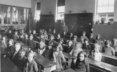
Photograph, Stawell State School Number 502 with student's 3rd Babies in classroom with Miss Matheson as the Teacher 1930, 1930
... Holloway, Jock Hill, Unknown, Unknown. Second Row - Miriam Colquhoun, Betty Wells, Venus Floyd, Audrey Roeby, Unknown, Allan Bell?, Gray?, Unknown, Unknown. Third Row - Ron? Byron, Alan Storer, Betty Chapman, Nina Lea, Dorothy Whiteside, Mavis Darker, Smith?, Unknown, Unknown. Fourth Row - Judy Campbell, Lesley Dalkin, Unknown, Shuttleworth?, Unknown, Valda Evers, Joyce Miller, Unknown. Fifth Row - Pauline Datson?, Dorothy Kingston, Smith?, Stan Anyon, Unknown, Paisley Bradley, Unknown, Unknown, Unknown, Unknown. TEACHER Miss Matheson This photograph came from the Vagg family...Holloway, Jock Hill, Unknown, Unknown. Second Row - Miriam Colquhoun, Betty Wells, Venus Floyd, Audrey Roeby, Unknown, Allan Bell?, Gray?, Unknown, Unknown. Third Row - Ron? Byron, Alan Storer, Betty Chapman, Nina Lea, Dorothy Whiteside, Mavis Darker, Smith?, Unknown, Unknown. Fourth Row - Judy Campbell, Lesley Dalkin, Unknown, Shuttleworth?, Unknown, Valda Evers, Joyce Miller, Unknown. Fifth Row - Pauline Datson?, Dorothy Kingston, Smith?, Stan Anyon, Unknown, Paisley Bradley, Unknown, Unknown, Unknown, Unknown. TEACHER Miss Matheson This photograph came from the Vagg family ...Photograph of children in classroom. State School 502 3rd. Babies 1930 Teacher Miss Matheson. Joan Vagg 1930 3rd Babies written on back. Listed Students Front Row R/L - Norma Chapman, George Holloway, Jock Hill, Unknown, Unknown. Second Row - Miriam Colquhoun, Betty Wells, Venus Floyd, Audrey Roeby, Unknown, Allan Bell?, Gray?, Unknown, Unknown. Third Row - Ron? Byron, Alan Storer, Betty Chapman, Nina Lea, Dorothy Whiteside, Mavis Darker, Smith?, Unknown, Unknown. Fourth Row - Judy Campbell, Lesley Dalkin, Unknown, Shuttleworth?, Unknown, Valda Evers, Joyce Miller, Unknown. Fifth Row - Pauline Datson?, Dorothy Kingston, Smith?, Stan Anyon, Unknown, Paisley Bradley, Unknown, Unknown, Unknown, Unknown. TEACHER Miss Matheson This photograph came from the Vagg family. Joan Vagg Died October 1932 - 7 years. Presumed she must be one of the girls. Students seated behind benches in Classroom with teacher.Joan Vagg 1930 3rd Babiesstawell education students