Showing 592 items matching "land owners"
-
 Sunshine and District Historical Society Incorporated
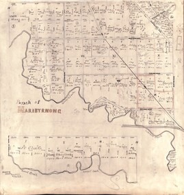
Map - Parish of Maribyrnong - Land owners on 12/6/1896, Haughton William
... Parish of Maribyrnong - Land owners on 12/6/1896...Beige coloured laminated photoprint of sketch showing land owners in Parish of Maribyrnong on 12 June 1896....Parish of Maribyrnong|Names of land owners|Albion & St Albans railway stations Kororoit creek|William Haughton|(Names of roads were digitally inserted for reference purposes in 2015)...Map Parish of Maribyrnong - Land owners on 12/6/1896 Haughton William ...Received by email from AmyParish of Maribyrnong|Names of land owners|Albion & St Albans railway stations Kororoit creek|William Haughton|(Names of roads were digitally inserted for reference purposes in 2015)maribyrnong, map -
 Lakes Entrance Historical Society
Map - Lakes Entrance Parish of Colquhoun map showing the streets and land with owners names
... Lakes Entrance Parish of Colquhoun map showing the streets and land with owners names......land owners...Map showing the streets and land with owners names...Township Roads and Streets land owners Map showing the streets and land with owners names Map Lakes Entrance Parish of Colquhoun map showing the streets and land with owners names ...Map showing the streets and land with owners namestownship, roads and streets, land owners -
Lakes Entrance Historical Society
Map - Land Owners Bumberrah to Lake Tyers
... Land Owners Bumberrah to Lake Tyers...Map showing land owners from Bumberrah to Lake Tyers. 3 pages...Lakes Entrance Historical Society 4 Marine Parade Lakes Entrance gippsland land records Townships Waterways Colquhoun Counties of Tambo and Tanjil Map showing land owners from Bumberrah to Lake Tyers. 3 pages Map Land Owners Bumberrah to Lake Tyers ...Map showing land owners from Bumberrah to Lake Tyers. 3 pagesColquhoun Counties of Tambo and Tanjilland records, townships, waterways -
 Ringwood and District Historical Society
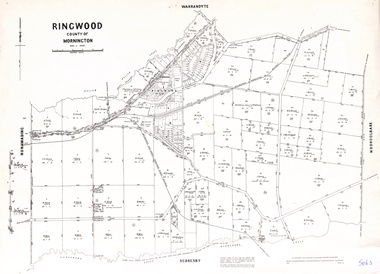
Map - Parish of Ringwood, County of Mornington, Victoria, Original Land Owners
... Original Land Owners....Laminated Parish map of Ringwood detailing original Land Owners' names, property locations and acreages. ...Ringwood and District Historical Society 125A Warrandyte Road Ringwood North melbourne Laminated Parish map of Ringwood detailing original Land Owners' names, property locations and acreages. ...Laminated Parish map of Ringwood detailing original Land Owners' names, property locations and acreages. Details reproduced in 1957 by the Department of Lands and Survey, Melbourne, from original surveys of varying dates. -
 Kiewa Valley Historical Society
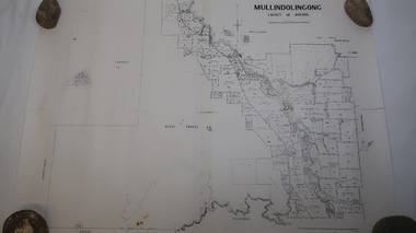
Map - Mullindolingong
... ...land owners...Land owners of land in the Kiewa Valley in 1928...Two sheets the same: (one old with paper joined together and the other is a copy without any joins. 21 6 1928 dated Map of Mullindolingong / County of Bogong showing land owners along the Kiewa River and beyond.Produced by the Department of Lands and Survey, Melbourne...Kiewa Valley Historical Society Mount Beauty Information Centre 31 Bogong High Plains Rd Mt Beauty high-country Land owners of land in the Kiewa Valley in 1928 The Kiewa Valley was farming country with families settling in the area prior to 1928 mullindolingong kiewa valley land owners families of the kiewa valley Two sheets the same: (one old with paper joined together and the other is a copy without any joins. 21 6 1928 dated Map of Mullindolingong / County of Bogong showing land owners along the Kiewa River and beyond.Produced by the Department of Lands and Survey, Melbourne Map - Mullindolingong ...Land owners of land in the Kiewa Valley in 1928The Kiewa Valley was farming country with families settling in the area prior to 1928 Two sheets the same: (one old with paper joined together and the other is a copy without any joins. 21 6 1928 dated Map of Mullindolingong / County of Bogong showing land owners along the Kiewa River and beyond.Produced by the Department of Lands and Survey, Melbournemullindolingong, kiewa valley, land owners, families of the kiewa valley -
Lakes Entrance Historical Society
Map - Map Allotments Colquhoun East, Department Lands and Survey, 10/3/1934
... land owners...Land owners and allotments Princes Highway Forest...Lakes Entrance Historical Society 4 Marine Parade Lakes Entrance gippsland land owners Forest Roads and Streets Land owners and allotments Princes Highway Forest Map Map Allotments Colquhoun East Department Lands and Survey H J Green Printer ...Land owners and allotments Princes Highway Forestland owners, forest, roads and streets -
Lakes Entrance Historical Society
Map - Kalimna Allotments
... ...land owners...Photocopies of roads and land owners names Lighthouse Reserve...Lakes Entrance Historical Society 4 Marine Parade Lakes Entrance gippsland Land Development land owners Roads and Streets Photocopies of roads and land owners names Lighthouse Reserve Map Kalimna Allotments ...Photocopies of roads and land owners names Lighthouse Reserveland development, land owners, roads and streets -
 Narre Warren and District Family History Group
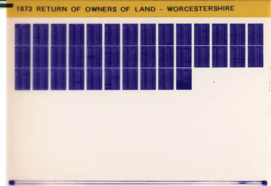
Film, West Surrey Family History Society, Return of Owners of Land Worcestershire, England 1873, 1990s
... Return of Owners of Land Worcestershire, England 1873...Worcestershire -- land owners...Narre Warren and District Family History Group 110 High Street Berwick melbourne England -- Worcestershire Worcestershire Worcestershire -- land owners The Return of Owners of Land, 1873 for Worcestershire provides a fascinating glimpse into land ownership during the Victorian era. ...The Return of Owners of Land, 1873 for Worcestershire provides a fascinating glimpse into land ownership during the Victorian era. It lists landowners with holdings of one acre or more, detailing the size and estimated rental value of their properties. This survey was part of a broader effort to address concerns about land monopolies and to provide transparency about land distribution. For Worcestershire, the records highlight the disparities in land ownership, with a small number of individuals owning vast estates while many others held smaller plots. The survey also includes information about common lands and waste lands in the county.Set of 1 microfiche non-fictionThe Return of Owners of Land, 1873 for Worcestershire provides a fascinating glimpse into land ownership during the Victorian era. It lists landowners with holdings of one acre or more, detailing the size and estimated rental value of their properties. This survey was part of a broader effort to address concerns about land monopolies and to provide transparency about land distribution. For Worcestershire, the records highlight the disparities in land ownership, with a small number of individuals owning vast estates while many others held smaller plots. The survey also includes information about common lands and waste lands in the county. england -- worcestershire, worcestershire, worcestershire -- land owners -
Lakes Entrance Historical Society
Map - Allotments Kalimna
... ...land owners...Map shows land owners, Lghthouse reserve, Reeves research...Lakes Entrance Historical Society 4 Marine Parade Lakes Entrance gippsland Township land owners reserves Township and Suburban Allotments Kalimna "Jemmy's Point" Parish of Colquhoun County of Tambo Map shows land owners, Lghthouse reserve, Reeves research Map Allotments Kalimna ...Map shows land owners, Lghthouse reserve, Reeves researchTownship and Suburban Allotments Kalimna "Jemmy's Point" Parish of Colquhoun County of Tambotownship, land owners, reserves -
Lakes Entrance Historical Society
Map - Map Suburban Sites East Cunninghame
... land owners...Map shows land owners within township of Cunninghame Parish of Colquhoun....Lakes Entrance Historical Society 4 Marine Parade Lakes Entrance gippsland land owners Township Waterways Map shows land owners within township of Cunninghame Parish of Colquhoun. ...Map shows land owners within township of Cunninghame Parish of Colquhoun.land owners, township, waterways -
Lakes Entrance Historical Society
Map - Map Sarsfield
... land owners...Map shows land owners and river Sarsfield. 2 pages 10440 and 10440.1...Lakes Entrance Historical Society 4 Marine Parade Lakes Entrance gippsland land owners Waterways Settlement Map shows land owners and river Sarsfield. 2 pages 10440 and 10440.1 Map Map Sarsfield ...Map shows land owners and river Sarsfield. 2 pages 10440 and 10440.1land owners, waterways, settlement -
Lakes Entrance Historical Society
Map - Newmerella County of Tambo Sheet 2, Dept. of Land and Survey, September 1951
... land owners...Map shows land owners Lake Corringle, Snowy River, Bass Strait....Lakes Entrance Historical Society 4 Marine Parade Lakes Entrance gippsland land owners Waterways Map shows land owners Lake Corringle, Snowy River, Bass Strait. ...Map shows land owners Lake Corringle, Snowy River, Bass Strait.land owners, waterways -
Lakes Entrance Historical Society
Map - Newmerella County of Tambo Sheet 1, Dept of Lands and Survey, September 1951
... land owners...Map shows land owners, Lake Corringle, Snowy River, Bass Strait...Lakes Entrance Historical Society 4 Marine Parade Lakes Entrance gippsland land owners Waterways Map shows land owners, Lake Corringle, Snowy River, Bass Strait Map Newmerella County of Tambo Sheet 1 Dept of Lands and Survey ...Map shows land owners, Lake Corringle, Snowy River, Bass Straitland owners, waterways -
Lakes Entrance Historical Society
Map - Tildesley West Sheet 2, A C Brooks Gov. Printer, 1965
... land owners...Map shows North Arm Lake Tyers, Colquhoun East land owners....Lakes Entrance Historical Society 4 Marine Parade Lakes Entrance gippsland land owners Waterways Settlement Map shows North Arm Lake Tyers, Colquhoun East land owners. ...Map shows North Arm Lake Tyers, Colquhoun East land owners.land owners, waterways, settlement -
Lakes Entrance Historical Society
Map - Tildesley West County of Tambo, A C Brooks Govv. Printer, 1965
... ...land owners...Map shows Nowa Nowa Arm in Lake Tyers, Colquhoun East, land owners, Bass Strait, Ninety Mile Beach....Lakes Entrance Historical Society 4 Marine Parade Lakes Entrance gippsland Waterways land owners Settlement Map shows Nowa Nowa Arm in Lake Tyers, Colquhoun East, land owners, Bass Strait, Ninety Mile Beach. ...Map shows Nowa Nowa Arm in Lake Tyers, Colquhoun East, land owners, Bass Strait, Ninety Mile Beach.waterways, land owners, settlement -
Lakes Entrance Historical Society
Map - Map Colquhoun East Counties of Tambo and Tanjil
... land owners...Map shows allotments with land owners names Lake Tyers, Tildesley West, Township of East Cunninghame, Red Bluff. 2 pages filed 10444 and 10444.1...Lakes Entrance Historical Society 4 Marine Parade Lakes Entrance gippsland land owners Townships Topography Map shows allotments with land owners names Lake Tyers, Tildesley West, Township of East Cunninghame, Red Bluff. 2 pages filed 10444 and 10444.1 Map Map Colquhoun East Counties of Tambo and Tanjil ...Map shows allotments with land owners names Lake Tyers, Tildesley West, Township of East Cunninghame, Red Bluff. 2 pages filed 10444 and 10444.1land owners, townships, topography -
Lakes Entrance Historical Society
Map - Bumberrah Counties of Dargo and Tambo
... ...land owners...Map showing land owners, state forest, Colquhoun North, Tambo River, Tambo Bay, Nicholson River. 5 maps A, B C, D, E. ...Lakes Entrance Historical Society 4 Marine Parade Lakes Entrance gippsland Waterways Forest land owners Map showing land owners, state forest, Colquhoun North, Tambo River, Tambo Bay, Nicholson River. 5 maps A, B C, D, E. ...Map showing land owners, state forest, Colquhoun North, Tambo River, Tambo Bay, Nicholson River. 5 maps A, B C, D, E. B is laminated, C, D, and E are photocopieswaterways, forest, land owners -
 Kiewa Valley Historical Society
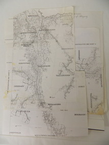
Parish Maps - Kiewa Valley
... kiewa valley. parish maps. land owners...They show how the Kiewa Valley was divided up into allotments for town dwellers and farmers and enables further research. kiewa valley. parish maps. land owners Two copies of Parish Maps of the towns in the Kiewa Valley. ...The Parish Maps show how the Counties were divided into allotments for buyers. On one the original owners are named and the sizes of their properties given. The reference numbers enable individuals research the history of the property. The other is on a smaller scale giving only the allotment numbers. The map with the names gives information on the early settlers of the Kiewa Valley. They show how the Kiewa Valley was divided up into allotments for town dwellers and farmers and enables further research.Two copies of Parish Maps of the towns in the Kiewa Valley. One gives the original owners and the other the reference numbers of the allotments.kiewa valley. parish maps. land owners -
 Kiewa Valley Historical Society
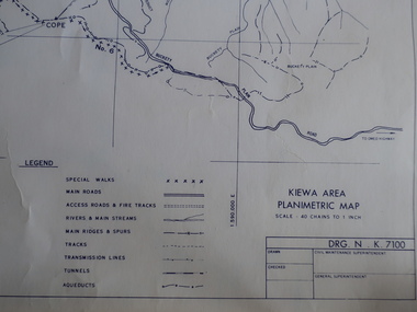
Maps - Kiewa Valley Parish Maps x3 and Kiewa Area Planimetric Map x1
... kiewa valley. parish maps. land owners...Many of these familie's descendants still live in the Kiewa Valley. kiewa valley. parish maps. land owners 1. Kiewa Area Planimetric Map (photo) 2. ...Planimetric maps are 2 dimensional representations of the Earth's surface, showing the location and spatial arrangement of features such as roads, buildings, and bodies of water. The parish maps show the occupiers with leases or licences of the land. These are updated by the Department of Lands regularly. The names of early settlers of the Kiewa Valley occupying land by lease or licence are shown. Many of these familie's descendants still live in the Kiewa Valley.1. Kiewa Area Planimetric Map (photo) 2. Wermatong, County of Bogong Parish Map 3. Mulllindolingong, County of Bogong Parish Map 4. Mullagong, County of Bogong Parish Map All black and white kiewa valley. parish maps. land owners -
 Bayside Gallery - Bayside City Council Art & Heritage Collection
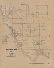
Map, Department of Crown Lands and Survey, Moorabbin, County of Bourke, c. 1918
... ...Land owners...Moorabbin County of Bourke Map Plan land subdivision land titles Foreshores Sndringham Hampton Beaumaris Highett Cheltenham Department of Lands and Survey Land owners cartographic material Borough of Sandringham Brighton Photolithograph. ...The cadastral map of the Parish of Moorabbin in Victoria (L.6104) shows parish boundaries and land ownership c. 1918 when Sandringham was a Borough.moorabbin, county of bourke, map, plan, land subdivision, land titles, foreshores, sndringham, hampton, beaumaris, highett, cheltenham, department of lands and survey, land owners, cartographic material, borough of sandringham, brighton -
 Bayside Gallery - Bayside City Council Art & Heritage Collection
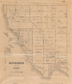
Map, Department of Crown Lands and Survey et al, Moorabbin, County of Bourke, Government Roads, 1920
... ...Land owners...Moorabbin County of Bourke Map Plan land subdivision land titles Foreshores Hampton Beaumaris Highett Cheltenham Department of Lands and Survey Land owners cartographic material Brighton Sandringham Town of Sandringham Government Roads Photolithograph of the Parish of Moorabbin (dated 17/7/1920) accompanied by original typed letter to the Town Clerk Sandringham from the Secretary for Department of Lands and Survey (dated 26/2/1934), notifying of dispatch of the map. ...The cadastral map of the Parish of Moorabbin in Victoria (L.6104) shows parish boundaries and land ownership 1920 when Sandringham was a Town. The government roads have been coloured in red pencil.moorabbin, county of bourke, map, plan, land subdivision, land titles, foreshores, hampton, beaumaris, highett, cheltenham, department of lands and survey, land owners, cartographic material, brighton, sandringham, town of sandringham, government roads -
Lakes Entrance Historical Society
Map - Township of Lakes Entrance
... ...land owners...Lakes Entrance Historical Society 4 Marine Parade Lakes Entrance gippsland Township Waterways land owners Plan of township showing property owners names Map Township of Lakes Entrance ...Plan of township showing property owners namestownship, waterways, land owners -
Lakes Entrance Historical Society
Map - East Cunninghame Parish of Colquhoun County of Tambo
... ...land owners...Lakes Entrance Historical Society 4 Marine Parade Lakes Entrance gippsland Township land owners Map shows allotments in Lakes Entrance with owners names. ...Map shows allotments in Lakes Entrance with owners names.township, land owners -
Whitehorse Historical Society Inc.
Map, Map of Mitcham, 1916?
... Showing main roads and large blocks of land with owners' names....Copy of early map of Mitcham showing main roads and large blocks of land with owners' names...Copy of early map of Mitcham showing main roads and large blocks of land with owners' names Map of Mitcham Map Map ...Copy of early map of Mitcham.Copy of early map of Mitcham showing main roads and large blocks of land with owners' namesCopy of early map of Mitcham. mitcham road mitcham, heatherdale road mitcham, whitehorse road mitcham, morton, william, ainger, f, morgan, r. r., harding, w, sergeant, r, mcclelland, john, wilson, w, cook, j -
 Federation University Historical Collection
Document, Declaration of Ernest by owners of land in Yendon being held as a site for Public Hall and Free Library; 1891, 1891
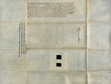
... Declaration of Ernest by owners of land in Yendon being held as a site for Public Hall and Free Library; 1891...Land that had been purchased - being part of Crown Allotment Five Section six, Township of Buninyong East, Parish of Buninyong, County of Grant, has been purchased "as a site for a public hall and free library for the use and benefit of the inhabitants of the Township of Yendon." declaration of ernest land title free library public hall yendon buninyong paris of buninyong county of grant john winterburn kemp philip ballantyne samuel henry mayo thomas dooley thomas watson Document stamped in green - 0122083 Signatures of; John Winterburn Kemp, Philip Ballantyne, Samuel Henry Mayo, Thomas Dooley, Thomas Watson Thick paper, hand written. Red dots indicate places for signatures Declaration of Ernest by owners ...Document outlining the agreement between five males, all residents of Yendon. Land that had been purchased - being part of Crown Allotment Five Section six, Township of Buninyong East, Parish of Buninyong, County of Grant, has been purchased "as a site for a public hall and free library for the use and benefit of the inhabitants of the Township of Yendon."Thick paper, hand written. Red dots indicate places for signatures Document stamped in green - 0122083 Signatures of; John Winterburn Kemp, Philip Ballantyne, Samuel Henry Mayo, Thomas Dooley, Thomas Watsondeclaration of ernest, land title, free library, public hall, yendon, buninyong, paris of buninyong, county of grant, john winterburn kemp, philip ballantyne, samuel henry mayo, thomas dooley, thomas watson -
 Narre Warren and District Family History Group
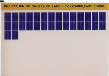
Film, Tim Wilcock et al, Return of Owners of Land Yorkshire (East Riding), England 1873, 1992-1995
... Return of Owners of Land Yorkshire (East Riding), England 1873...The number of owners of land, whether built upon or not, of less than one acre, with the estimated aggregate gross estimated rental of the lands of such owners 3. ..."This return is intended to show with regard to England and Wales (exclusive of the Metropolis) - 1. The number and names of owners of land of one acre and upwards, whether built upon or not, in each County, with the estimated acreage and annual gross estimated rental of the property belonging to each owner 2. The number of owners of land, whether built upon or not, of less than one acre, with the estimated aggregate gross estimated rental of the lands of such owners 3. The estimated extent of commons and waste lands in each County."--Explanatory statement.Set of 1 microfiche non-fiction"This return is intended to show with regard to England and Wales (exclusive of the Metropolis) - 1. The number and names of owners of land of one acre and upwards, whether built upon or not, in each County, with the estimated acreage and annual gross estimated rental of the property belonging to each owner 2. The number of owners of land, whether built upon or not, of less than one acre, with the estimated aggregate gross estimated rental of the lands of such owners 3. The estimated extent of commons and waste lands in each County."--Explanatory statement. yorkshire -- east riding, yorkshire -- east riding -- land tenure, yorkshire -- east riding -- genealogy -
Lakes Entrance Historical Society
Map - Plan of Township of Lakes Entrance
... Plan of township of Lakes Entrance showing waterways and land owners...Lakes Entrance Historical Society 4 Marine Parade Lakes Entrance gippsland Township Waterways Maps Plan of township of Lakes Entrance showing waterways and land owners Map Plan of Township of Lakes Entrance ...Plan of township of Lakes Entrance showing waterways and land ownerstownship, waterways, maps -
Lakes Entrance Historical Society
Map - Township of Kalimna
... Map shows allotments and land owners, Rigby Island, The Narrows....Lakes Entrance Historical Society 4 Marine Parade Lakes Entrance gippsland Islands Waterways Township Map shows allotments and land owners, Rigby Island, The Narrows. Map Township of Kalimna ...Map shows allotments and land owners, Rigby Island, The Narrows.islands, waterways, township -
Lakes Entrance Historical Society
Map - Colquhoun East County Tambo, Government Printer
... Map of Lake Tyers forest showing Aboriginal Reserve and Land owners...Lakes Entrance Historical Society 4 Marine Parade Lakes Entrance gippsland Waterways Aboriginal history Settlement Map of Lake Tyers forest showing Aboriginal Reserve and Land owners Map Colquhoun East County Tambo Government Printer ...Map of Lake Tyers forest showing Aboriginal Reserve and Land ownerswaterways, aboriginal history, settlement -
 Kew Historical Society Inc
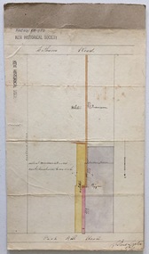
Plan, Survey Plan, Park Hill Road, Kew, 1880-1890
... The unnamed survey plan includes names of land owners in addition to measurements (2 chains to 1 inch) and streets. ...The plan includes street names, land measurements and land owners....The unnamed survey plan includes names of land owners in addition to measurements (2 chains to 1 inch) and streets. ...The streets identified on the survey plan - Cotham Road, Park Hill Road East, Park Hill Road West in Kew were each gazetted by the Victorian Government in 1865. The hand-coloured survey plan was completed by Holland Loxton, Town Clerk and Surveyor of the Borough of Kew from 1866. The unnamed survey plan includes names of land owners in addition to measurements (2 chains to 1 inch) and streets. Named owners include Webster, Payne and Francom which will enable us to narrow down the creation date of the survey.Handdrawn survey plan by a former surveyor and town clerk of KewHand drawn and coloured survey plan created by Holland Loxton, Surveyor and Town Clerk of Kew, showing land owned by Payne in Park Hill Road, Kew. The plan includes street names, land measurements and land owners.surveys - kew, maps - kew, holland loxton, park hill road - kew, holland loxton -- surveyor, survey plans -- parkhill road -- kew (vic.)