Showing 31 items matching "leading lights"
-
 Port Melbourne Historical & Preservation Society
Document - Commissioning brief, Leading Lights installation design, 1999
... Commissioning brief, Leading Lights installation design......Leading Lights...Commissioning brief for artists regarding design of installation on the foreshore on the sightline of the Leading Lights...'Confidential, Beacon Cove Leading Lights'...Port Melbourne Historical & Preservation Society Port Melbourne Town Hall 333 Bay Street Port Melbourne melbourne Used by donor as member of the judging panel Beacons Melbourne Harbor Trust - Port of Melbourne Authority Arts and Entertainment - Community Arts Leading Lights Port Melbourne Historical & Preservation Society PMHPS Friends of Port Melbourne Foreshore Mirvac Pat GRAINGER 'Confidential, Beacon Cove Leading Lights' Commissioning brief for artists regarding design of installation on the foreshore on the sightline of the Leading Lights Document Commissioning brief, Leading Lights installation design City of Port Phillip ...Used by donor as member of the judging panelCommissioning brief for artists regarding design of installation on the foreshore on the sightline of the Leading Lights'Confidential, Beacon Cove Leading Lights'beacons, melbourne harbor trust - port of melbourne authority, arts and entertainment - community arts, leading lights, port melbourne historical & preservation society, pmhps, friends of port melbourne foreshore, mirvac, pat grainger -
Port Melbourne Historical & Preservation Society
Document - Correspondence, Leading Lights installation design, 1999
... Correspondence, Leading Lights installation design......Leading Lights...Correspondence re panel regarding design of installation on the foreshore on the sightline of the Leading Lights...'Confidential, Beacon Cove Leading Lights'...Port Melbourne Historical & Preservation Society Port Melbourne Town Hall 333 Bay Street Port Melbourne melbourne Used by donor as member of the judging panel Beacons Melbourne Harbor Trust - Port of Melbourne Authority Arts and Entertainment - Community Arts Leading Lights Port Melbourne Historical & Preservation Society PMHPS Friends of Port Melbourne Foreshore Mirvac Pat GRAINGER 'Confidential, Beacon Cove Leading Lights' Correspondence re panel regarding design of installation on the foreshore on the sightline of the Leading Lights Document Correspondence, Leading Lights installation design City of Port Phillip ...Used by donor as member of the judging panelCorrespondence re panel regarding design of installation on the foreshore on the sightline of the Leading Lights'Confidential, Beacon Cove Leading Lights'beacons, melbourne harbor trust - port of melbourne authority, arts and entertainment - community arts, leading lights, port melbourne historical & preservation society, pmhps, friends of port melbourne foreshore, mirvac, pat grainger -
Port Melbourne Historical & Preservation Society
Document - Winning design, Leading Lights installation design, 1999
... Winning design, Leading Lights installation design......Leading Lights...Artist's concept for winning design regarding design of installation on the foreshore on the sightline of the Leading Lights...'Confidential, Beacon Cove Leading Lights'...Port Melbourne Historical & Preservation Society Port Melbourne Town Hall 333 Bay Street Port Melbourne melbourne Used by donor as member of the judging panel Beacons Melbourne Harbor Trust - Port of Melbourne Authority Arts and Entertainment - Community Arts Leading Lights Port Melbourne Historical & Preservation Society PMHPS Friends of Port Melbourne Foreshore Mirvac Pat GRAINGER 'Confidential, Beacon Cove Leading Lights' Artist's concept for winning design regarding design of installation on the foreshore on the sightline of the Leading Lights Document Winning design, Leading Lights installation design City of Port Phillip ...Used by donor as member of the judging panelArtist's concept for winning design regarding design of installation on the foreshore on the sightline of the Leading Lights'Confidential, Beacon Cove Leading Lights'beacons, melbourne harbor trust - port of melbourne authority, arts and entertainment - community arts, leading lights, port melbourne historical & preservation society, pmhps, friends of port melbourne foreshore, mirvac, pat grainger -
 Port Melbourne Historical & Preservation Society
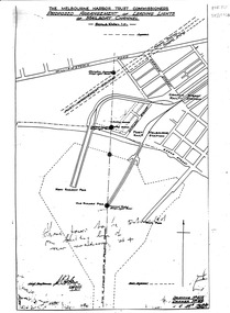
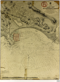
Map, Leading Lights of Port Melbourne Channel, 1926
... Leading Lights of Port Melbourne Channel......leading lights...Proposed arrangement of Leading Lights of mailboat channel at Port Melbourne piers...Port Melbourne Historical & Preservation Society Port Melbourne Town Hall 333 Bay Street Port Melbourne melbourne beacons melbourne harbor trust - port of melbourne authority leading lights Proposed arrangement of Leading Lights of mailboat channel at Port Melbourne piers Leading Lights of Port Melbourne Channel Map ...Proposed arrangement of Leading Lights of mailboat channel at Port Melbourne piersbeacons, melbourne harbor trust - port of melbourne authority, leading lights -
Port Melbourne Historical & Preservation Society
Archive - File, Port Melbourne Leading Lights, c. 1995
... Port Melbourne Leading Lights......Leading Lights...File of photocopies prepared for Angela Wallace in the early days of the City of Port Phillip, as reference for commissioning public art installation re the Leading Lights - - extracts from heritage study done about 1990 ;letter to Angela;...Port Melbourne Historical & Preservation Society Port Melbourne Town Hall 333 Bay Street Port Melbourne melbourne Found in Pat Grainger's archives Piers and Wharves Leading Lights Arts and entertainment Beacons Angela Wallace Leading Lights File of photocopies prepared for Angela Wallace in the early days of the City of Port Phillip, as reference for commissioning public art installation re the Leading Lights - - extracts from heritage study done about 1990 ;letter to Angela; Port Melbourne Leading Lights Archive File ...Found in Pat Grainger's archivesFile of photocopies prepared for Angela Wallace in the early days of the City of Port Phillip, as reference for commissioning public art installation re the Leading Lights - - extracts from heritage study done about 1990 ;letter to Angela;piers and wharves, leading lights, arts and entertainment, beacons, angela wallace, leading lights -
 Flagstaff Hill Maritime Museum and Village
Document - Report, Jet Probings, Warrnambool Harbour, 16-10-1929
... ...leading lights...The report mentions lining up with the wooden jetty, the end of the breakwater and the leading lights. It mentions sand, loose rock and rock. ...The report mentions lining up with the wooden jetty, the end of the breakwater and the leading lights. It mentions sand, loose rock and rock. ...This report lists the depths of water and the consistency of the seabed surrounding the Warrnambool Harbour in October 1929, The information, often referred to as 'soundings', was obtained by Jet Probing,. In earlier days a lead line was used to perform a similar task. The author of the document is unknown. Jet Probing is a method used for underwater archaeology, cable installation and coastal engineering. A jet probe is a machine that produces a strong jet of water that penetrates the layers of sediment on the seabed, determining their depth, thickness and consistency. It provides a survey of the seabed and can be used as an aid to engineering design and construction. The report mentions lining up with the wooden jetty, the end of the breakwater and the leading lights. It mentions sand, loose rock and rock. It tells of stopping work due to the water being too rough, the pipe choking, difficulty in connecting pipes, and pipe joint breaking as it tried to get through the sand, The report in the document is significant for its connection with the Warrnambool Harbour, Warrnambool Breakwater, Warrnambool Jetty and Lady Bay. The report gives figures for the depth and consistency of the water and seabed at a particular point in time and can be used to compart with similar figures taken at different times. The results could determine plans for future engineering works.Report, titled 'Jet Probings, Warrnambool Harbour'. Two pages of cream coloured paper with hand written notes in pen and ink. Report covers three days of Jet Probings, with resulting figures and comments, for the depths of the surroundings of the Warrnambool Harbour. The report is in point form, with some underlining. Dates of recordings are 14-10-29, 15-10-29 and 16-10-29. (1929) The situation of the harbour had become a real problem by 1910 and required continuous dredging. In 1914 the Breakwater was extended but proved to be a failure because the work began to subside and by 1920 about two thirds of the harbour was silted up. Alterations made in the 1920's increased the silting problem. The soundings and Jet Probings were done after the Royal Commission of 1923, when the damaged stonework on the seaward side of the Warrnambool Breakwater, caused by the action of the sea, was the subject of enquiry. A conference between the Public Works, Water Commission and the Harbour Trust concluded that it would less costly to make repairs to prevent further damage rather than replaced the damage portion of the wall. A contract was raised in late 1924 to deposit rubble on the damaged side of the breakwater to minimise the Southern Ocean’s destructive action and work had started by August 1925. By the 1940's the harbour was no longer used. More alterations were made in the 1950's and 1960's. document, depth, warrnambool harbour, 1929, soundings, jet probe, jet probing, seabed, map of seabed, underwater engineering, warrnambool jetty, warrnambool breakwater, breakwater upgrade, leading lights, chart the harbour, flagstaff hill, warrnambool, flagstaff hill maritime museum & village, maritime museum, maritime village, shipwreck coast, lady bay, port of warrnambool, breakwater, jetty, pier, vhr h2024, royal commission, 1923, public works, water commission, harbour trust, victorian harbours -
Port Melbourne Historical & Preservation Society
Photograph, Aerial Survey of Port Melbourne; December 1945, 2105
... ...Leading Lights...Eclipse Picture Theatre Brookes Lemos Ltd Built Environment Local Government Natural Environment Built Environment - Industrial Religion - Roman Catholic Church (St Josephs) GMH General Motors-Holden Rotten Row Sport - Trotting J Kitchen & Sons Pty Ltd Australian Wool Board Government Aircraft Factory GAF Commonwealth Aircraft Corporation CAC North Port Oval Fire and Fire Services Market Reserve Religion - Presbyterian Church Leading Lights Foresters Arms Hotel Commonwealth Government Engine Works St Josephs Catholic Primary School Mission to Seamen Centenary Bridge Naval Drill Hall Mail Exchange Gasworks Piers and Wharves - Town Pier Robert Harper & Co Ltd RAN - Royal Australian Navy HMAS Lonsdale Port Melbourne Yacht Club PMYC Piers and Wharves - MHT Timber Wharves Aerial Survey of Port Melbourne; December 1945 Large photograph mounted on foam board. ...Seventeen (17) individual photos were joined together by John KIRBY to make a compsite image.Aerial Survey of Port Melbourne; December 1945 Large photograph mounted on foam board. Shows aerial view of Port Melbourne showing its extent from the Bay. Panel on right hand side has key to numbered areas on map . PMHPS logo on top left cornereclipse picture theatre, brookes lemos ltd, built environment, local government, natural environment, built environment - industrial, religion - roman catholic church (st josephs), gmh, general motors-holden, rotten row, sport - trotting, j kitchen & sons pty ltd, australian wool board, government aircraft factory, gaf, commonwealth aircraft corporation, cac, north port oval, fire and fire services, market reserve, religion - presbyterian church, leading lights, foresters arms hotel, commonwealth government engine works, st josephs catholic primary school, mission to seamen, centenary bridge, naval drill hall, mail exchange, gasworks, piers and wharves - town pier, robert harper & co ltd, ran - royal australian navy, hmas lonsdale, port melbourne yacht club, pmyc, piers and wharves - mht timber wharves -
Port Melbourne Historical & Preservation Society
Photograph - Waiting room, western finger pier, Station Pier, Port Melbourne, Alison Kelly, c. 1990
... ...leading lights...Port Melbourne Historical & Preservation Society Port Melbourne Town Hall 333 Bay Street Port Melbourne melbourne piers and wharves - station pier beacons west gate bridge alison kelly leading lights Colour photograph of waiting room for paddle steamer, western finger pier, Station Pier, with views of seaward beacon and West Gate Bridge, 1990 Photograph Waiting room, western finger pier, Station Pier, Port Melbourne Alison Kelly ...Colour photograph of waiting room for paddle steamer, western finger pier, Station Pier, with views of seaward beacon and West Gate Bridge, 1990piers and wharves - station pier, beacons, west gate bridge, alison kelly, leading lights -
Port Melbourne Historical & Preservation Society
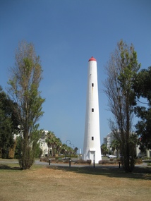
Photograph - Front beacon, Port Melbourne, Alison Kelly, c. 1990
... ...leading lights...Port Melbourne Historical & Preservation Society Port Melbourne Town Hall 333 Bay Street Port Melbourne melbourne beacons piers and wharves - princes pier alison kelly leading lights View of off-shore beacon looking west towards Williamstown, c 1990 Photograph Front beacon, Port Melbourne Alison Kelly ...View of off-shore beacon looking west towards Williamstown, c 1990beacons, piers and wharves - princes pier, alison kelly, leading lights -
Port Melbourne Historical & Preservation Society
Photograph - Front beacon, Port Melbourne, Alison Kelly, c. 1990
... ...leading lights...Port Melbourne Historical & Preservation Society Port Melbourne Town Hall 333 Bay Street Port Melbourne melbourne beacons piers and wharves - princes pier alison kelly leading lights View of off-shore beacon looking west towards Princes Pier c 1990 Photograph Front beacon, Port Melbourne Alison Kelly ...View of off-shore beacon looking west towards Princes Pier c 1990beacons, piers and wharves - princes pier, alison kelly, leading lights -
 Port Melbourne Historical & Preservation Society
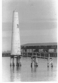
Photograph - Outer beacon showing remaining portion of jetty, c. 1977
... ...leading lights...Port Melbourne Historical & Preservation Society Port Melbourne Town Hall 333 Bay Street Port Melbourne melbourne transport - shipping leading lights In ink: 'Lighthouse between Princes Pier and Station Pier' '191' 'Roger Gould Neg No.' ...Black and white photograph of outer beacon, showing remaining portion of jetty and part of Prince's Pier c 1977In ink: 'Lighthouse between Princes Pier and Station Pier' '191' 'Roger Gould Neg No.' 'C.C.'transport - shipping, leading lights -
 Port Melbourne Historical & Preservation Society
Photograph - Guiding Beacons, Fisher Folk of Fishermans Bend Exhibition, David Thompson, Oct 2006
... ...Leading Lights...Fisher Folk of Fishermans Bend PMHPS Port Melbourne Historical & Preservation Society Celebrations Fetes and Exhibitions David THOMPSON Fishermans Bend Beacons Leading Lights Colour digital photograph of the Guiding Beacons panel on display at the Fisher Folk of Fishermans Bend Exhibition at Port Melbourne Town Hall, Oct-Nov 2006. ...Fisher Folk of Fishermans Bend by Allan MEIERS was published by PMHPS in 2006. The book was launched by CoPP Mayor, Janet BOLITHO on 24 Oct 2006 at Port Melbourne Town Hall with an exhibition to accompany the launch that ran until Monday 14 November 2006. Ann SMALLPAGE took photos of the launch (Cat No 2205.01 - .29) and David THOMPSON took photos of the Exhibition (Cat No 5157.01 - .33). Colour digital photograph of the Guiding Beacons panel on display at the Fisher Folk of Fishermans Bend Exhibition at Port Melbourne Town Hall, Oct-Nov 2006.fisher folk of fishermans bend, pmhps, port melbourne historical & preservation society, celebrations fetes and exhibitions, david thompson, fishermans bend, beacons, leading lights -
 Port Melbourne Historical & Preservation Society
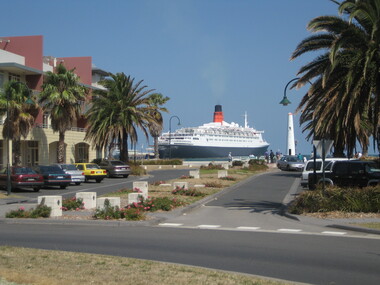
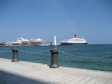
Photograph - QE2, Outer West, Station Pier, Port Melbourne, David Thompson, Feb 2007
... ...Leading Lights...Piers and Wharves - Station Pier Transport - Shipping QE2 Leading Lights Beacon Vista Beacons Digital colour photograph of the Queen Elizabeth II laying at outer west berth of Station Pier, 2007 viewed from Beacon Vista. ...Digital colour photograph of the Queen Elizabeth II laying at outer west berth of Station Pier, 2007 viewed from Beacon Vista.piers and wharves - station pier, transport - shipping, qe2, leading lights, beacon vista, beacons -
 Port Melbourne Historical & Preservation Society
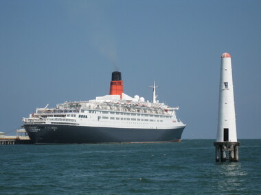
Photograph - QE2, Outer West, Station Pier, Port Melbourne, David Thompson, Feb 2007
... ...Leading Lights...Piers and Wharves - Station Pier Transport - Shipping QE2 Leading Lights Beacons Digital colour photograph of the Queen Elizabeth II laying at outer west berth of Station Pier, 2007. ...Digital colour photograph of the Queen Elizabeth II laying at outer west berth of Station Pier, 2007.piers and wharves - station pier, transport - shipping, qe2, leading lights, beacons -
 Port Melbourne Historical & Preservation Society
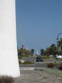
Photograph - Beacon Vista, David Thompson, Feb 2007
... Leading Lights...Leading Lights Beacon Vista Beacons Digital colour photograph looking down Beacon Vista from the inland beacon to the sea. ...Digital colour photograph looking down Beacon Vista from the inland beacon to the sea.leading lights, beacon vista, beacons -
 Port Melbourne Historical & Preservation Society
Photograph - QE2, Outer West, Station Pier, Port Melbourne, David Thompson, Feb 2007
... ...Leading Lights...Piers and Wharves - Station Pier Transport - Shipping QE2 Leading Lights Spirit of Tasmania Beacons Digital colour photograph of the Queen Elizabeth II laying at outer west berth of Station Pier, 2007. ...Digital colour photograph of the Queen Elizabeth II laying at outer west berth of Station Pier, 2007. A naval vessel is at the inner west berth and the Spirit of Tasmania is at inner east.piers and wharves - station pier, transport - shipping, qe2, leading lights, spirit of tasmania, beacons -
 Port Melbourne Historical & Preservation Society
Photograph - Beacon Vista, David Thompson, Feb 2007
... Leading Lights...Leading Lights Beacon Vista Beacons Digital colour photograph looking down Beacon Vista from the inland beacon to the sea. ...Digital colour photograph looking down Beacon Vista from the inland beacon to the sea.leading lights, beacon vista, beacons -
 Port Melbourne Historical & Preservation Society
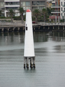
Photograph - Sea Beacon
... Leading Lights...Leading Lights Beacons Digital colour photograph of the sea beacon taken from an elevated position. ...Digital colour photograph of the sea beacon taken from an elevated position.leading lights, beacons -
 Port Melbourne Historical & Preservation Society
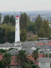
Photograph - Land Beacon
... Leading Lights...Leading Lights Beacons Beacon Cove Digital colour photograph of the land beacon looking over the roofs of Beacon Cove from an elevated position. ...Digital colour photograph of the land beacon looking over the roofs of Beacon Cove from an elevated position.leading lights, beacons, beacon cove -
 Flagstaff Hill Maritime Museum and Village
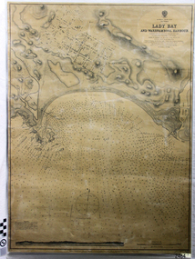
Document - Navigation Chart, Admiralty Office, Lady Bay and Warrnambool Harbour, 1893
... It has sounding details, and angles of line from the leading lights....Ca - - - request of 15-8-10 [initials] " Notes and lines in red pen, including a grid of sounding numbers: "1300" "1050" "1200" "Possible Extension of Dock" "19-2-25" "Dock Dredged to 20 Ft" Notes and lines in blue pen "Extension of Dock to accommodate vessels drawing 20 Feet" and "Light not visible south of this line" Red dots (4) with yellow highlight at both leading lights, breakwater and jetty...It has sounding details, and angles of line from the leading lights. Lady Bay and Warrnambool Harbour Document Navigation Chart England London Admiralty Office ...This navigation cart of Lady Bay and Warrnambool Harbour was originally surveyed in 1870 but this version includes the update for magnetic variation in 1893. Since the printing of the chart several annotations have been added. These include an additional stamp dated 15-8-1910, a handwritten comment across the top of the page dated August 1910, and another handwritten comment regarding the ‘Proposed Extension of Dock’ dated 19-2-1925, plus connected drawings, notes and figures. The 1925 proposal on this chart may have been a reaction to the Royal Commission of 1923, when the damaged stonework on the seaward side of the Warrnambool Breakwater, caused by the action of the sea, was the subject of enquiry. A conference between the Public Works, Water Commission and the Harbour Trust concluded that it would less costly to make repairs to prevent further damage rather than replaced the damage portion of the wall. A contract was raised in late 1924 to deposit rubble on the damaged side of the breakwater to minimise the Southern Ocean’s destructive action and work had started by August 1925. The Breakwater construction had begun in 1874 and was completed in 1890. The Victorian Government had commissioned Sir John Coode, a British harbour engineer, to present a plan to complete the Warrnambool Breakwater but his original plan was too expensive. He prepared a revised plan for a shorter structure. The construction proved to be too short to protect adequately from the weather and didn't allow enough depth for larger vessels to come into port. The decreasing trade was further affected by siltation in the bay due to the breakwater, and the completion of the railway line. The situation of the harbour became a real problem by 1910 and required continuous dredging. In 1914 the Breakwater was extended but proved to be a failure because the work began to subside and by 1920 about two thirds of the harbour was silted up. Alterations made in the 1920's increased the silting problem and by the 1940's the harbour was no longer used. More alterations were made in the 1950's and 1960's. This chart is significant for its strong connection to the maritime history of Warrnambool Harbour and Lady Bay and the Warrnambool Breakwater. The Warrnambool Breakwater is registered as a place of significance on the Victorian Heritage Database (VHR H2024). The Warrnambool Breakwater is one of the most important late 19th century maritime engineering projects in Victoria and significant in the development of Victorian coastal shipping. It is also significant for its connection with British harbour engineer, Sir John Coode. The chart is a historical record of structures existing in 1893; the Warrnambool Jetties, Warrnambool Breakwater in Lady Bay, the leading lights (lighthouses), streets, roads, bridges and many buildings. It also shows the lay of the land and seabed. Navigation Chart: Lady Bay and Warrnambool Harbour, Australia - South Coast - Victoria. Surveyed by Nav. Lieut. H.J. Stanley, R.N., 1870. Updated for Magnetic Variation, 1893. The rectangular chart is printed on heavy cream paper. Stamps are shaped rectangular, oval and round. Around the Breakwater and Jetty area are handwritten notes, dotted and joined lines, numbers and signatures, and shading of red and green. The chart shows the surrounds of Warrnambool Harbour, Lady Bay, the Breakwater and Jetty, roads, bridges and the streets in Warrnambool. It has sounding details, and angles of line from the leading lights.Stamp, rectangular, including "AUG 1910" Stamp, double oval " - - - -CHART" Stamp, hand drawn, red circle, with "B" inside Hand written note "22-8-1910 - - - - - of surveying C. Ca - - - request of 15-8-10 [initials] " Notes and lines in red pen, including a grid of sounding numbers: "1300" "1050" "1200" "Possible Extension of Dock" "19-2-25" "Dock Dredged to 20 Ft" Notes and lines in blue pen "Extension of Dock to accommodate vessels drawing 20 Feet" and "Light not visible south of this line" Red dots (4) with yellow highlight at both leading lights, breakwater and jettyflagstaff hill, warrnambool, flagstaff hill maritime museum & village, maritime museum, maritime village, shipwreck coast, map, chart, navigation chart, plan, lady bay, warrnambool harbour, port of warrnambool, breakwater, jetty, pier, dock extension, proposed extension, vhr h2024, 1870, 1893, 1910, 1925, warrnambool town late 1800s, warrnambool streets late 1800s royal commission, 1923, public works, water commission, harbour trust, victorian harbours, sir jon coode -
Port Melbourne Historical & Preservation Society
Film - Video Recording - Digital, COPP THIS!, c.2005
... hosted by Tracey HARVEY about Port Melbourne Town Hall, Bank houses, leading lights and the Port Melbourne Historical & Historical Society....hosted by Tracey HARVEY about Port Melbourne Town Hall, Bank houses, leading lights and the Port Melbourne Historical & Historical Society. ...One digital copy from the series COPP This! hosted by Tracey HARVEY about Port Melbourne Town Hall, Bank houses, leading lights and the Port Melbourne Historical & Historical Society.local government - city of port phillip, port melbourne town hall, port melbourne historical & preservation society -
Port Melbourne Historical & Preservation Society
Domestic object - Lamp, Leading Light, Douglas McKenzie, 1980 - 1989
... Electric table lamp base crafted by Doug McKenzie from two wooden replicas representing the Leading Lights, souvenired from the Port Melbourne Town Hall auditorium when it was reconstrcted c 1982. ...He gave this piece to Pat Grainger who kept it at home until he died, then donated it to the PMHPS collection. built environment - civic beacons handcrafts doug mckenzie Electric table lamp base crafted by Doug McKenzie from two wooden replicas representing the Leading Lights, souvenired from the Port Melbourne Town Hall auditorium when it was reconstrcted c 1982. ...Doug McKenzie collected these lighthouse replicas which were semi cylindrical and mounted on some substance originally. They have been joined and electrified . He gave this piece to Pat Grainger who kept it at home until he died, then donated it to the PMHPS collection.Electric table lamp base crafted by Doug McKenzie from two wooden replicas representing the Leading Lights, souvenired from the Port Melbourne Town Hall auditorium when it was reconstrcted c 1982. "Lighthouse" base brown with gold "light area.built environment - civic, beacons, handcrafts, doug mckenzie -
 Port Melbourne Historical & Preservation Society
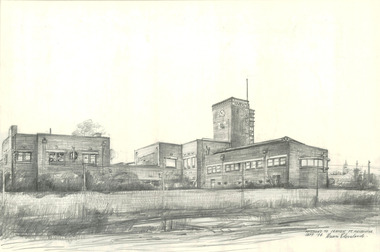
Drawing - Various Port Melbourne locations, Brian Cleveland, Brian Cleveland, 1990s
... Sites include: Centenary Bridge (including demolition) ; ships ; Princes Pier ; Station Pier ; structures and cranes on piers ; cable tram sheds ; London Hotel ; foreshore views ; Beacons (leading lights) ; kiosks ; Missions to Seamen building: railway stations....Sites include: Centenary Bridge (including demolition) ; ships ; Princes Pier ; Station Pier ; structures and cranes on piers ; cable tram sheds ; London Hotel ; foreshore views ; Beacons (leading lights) ; kiosks ; Missions to Seamen building: railway stations. ...Brian Cleveland taught art to Swinburne students from the 1970s to 1990s and sketched and recorded iconic areas of the city that were scheduled to vanish or be seriously altered. The Port Melbourne drawings were predominantly done in the 1990sSeventy-two (72)) pencil drawings (some with watercolour washes) by Brian Cleveland. Sites include: Centenary Bridge (including demolition) ; ships ; Princes Pier ; Station Pier ; structures and cranes on piers ; cable tram sheds ; London Hotel ; foreshore views ; Beacons (leading lights) ; kiosks ; Missions to Seamen building: railway stations.built environment, built environment - civic, piers and wharves - princes pier, piers and wharves - station pier, engineering - bridges, brian cleveland, centenary bridge, missions to seamen -
Port Melbourne Historical & Preservation Society
Archive, Janet Bolitho, Bayside Archival, 2003 - 2004
... Includes a summary of the proposed development, various correspondence with key activists against the proposal; as well as signed copyright papers releasing their recorded interviews; the outrageous project timeline; Brian COULDREY's submissions on the Leading Lights and a catalogue thus far...Includes a summary of the proposed development, various correspondence with key activists against the proposal; as well as signed copyright papers releasing their recorded interviews; the outrageous project timeline; Brian COULDREY's submissions on the Leading Lights and a catalogue thus far Bayside Archival Archive Janet Bolitho ...Janet BOLITHO took on the organising of existing material on "Bayside" as Beacon Cove neared completion: interviewing key people involved in environmental hearings and protestA black 2-ring binder containing summary of material on the "Bayside" project collection as it stood in 2003/04. Compiled by Janet BOLITHO. Includes a summary of the proposed development, various correspondence with key activists against the proposal; as well as signed copyright papers releasing their recorded interviews; the outrageous project timeline; Brian COULDREY's submissions on the Leading Lights and a catalogue thus fartown planning - proposals shelved - bayside, public action campaigns, local government - city of port melbourne, built environment, swallow street, bain street, the bayside project, janet bolitho, lyn allison, terry chumpley, brian couldrey, john drury, pat grainger, ian mckay, barry merat, evan ogilvy, susan reidy, jenny turnbull, noel turnbull, ronald 'bunna' walsh, perce mcguire white, perce white -
 Mission to Seafarers Victoria
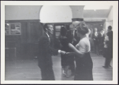
Photograph - Photograph, Black and white, Bill Doyle (Reverend C.J. Eldridge-Doyle), c. 1955
... The photograph is of historical significance as it is a documentation of one of many social events held by the Ladies Harbour Lights Guild at the Mission to Seafarers dance lhlg flying angel club seamen flinders street Black and white photograph of a dance held in the Mission to Seafarers main hall. The foreground shows A man to the left and a woman to the right dancing together. There is another couple dancing behind them. The background shows two of the archways leading ...The image shows us one of the many dances, or functions, held at the Mission to Seafarers Melbourne, It shows the main hall in its original condition and the way it was used at the time. The dance shown here is an example of the work of the Ladies Harbour Lights Guild, which held fundfraisers and social events at the Mission.This photograph is a reflection of the main hall, in original condition, and its use circa mid-1950s. The photograph is of historical significance as it is a documentation of one of many social events held by the Ladies Harbour Lights Guild at the Mission to SeafarersBlack and white photograph of a dance held in the Mission to Seafarers main hall. The foreground shows A man to the left and a woman to the right dancing together. There is another couple dancing behind them. The background shows two of the archways leading out of the main hall. The floors are the original hardwood floorboards.dance, lhlg, flying angel club, seamen, flinders street -
 Mission to Seafarers Victoria
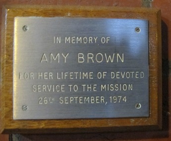
Plaque - Memorial Plaque, Amy Neville Brown (1882-1974), 1976
... Lights Guild ( Honorary General Secretary in the 30s) then the Flying Angel League. She passed away in September 1974. A protege and friend of the Godfreys and Ina Higgins she actively assisted in setting up school branches of LHLG and eventually became a leading member in the 1930s....Lights Guild ( Honorary General Secretary in the 30s) then the Flying Angel League. She passed away in September 1974. A protege and friend of the Godfreys and Ina Higgins she actively assisted in setting up school branches of LHLG and eventually became a leading member in the 1930s. ...Amy Neville Brown (1882-1974) was a longlife member of the Mission to Seafarers ladies' Committees: 1910 - Amy is first mentioned in our records as LHLG branch secretary for Elsternwick. (from diaries written by her and her sister Beatrice during 1909-1913 and held at the Glen Eira Historical Society, Amy tells she attends “kirk” with Miss Godfrey about once a month and each time they go to the “Institute” afterwards.) 1918 - 1922 sees Amy as “Schools secretary” LHLG. 1933 - Miss A N Brown becomes Honorary Secretary of the LHLG. 1946 – LHLG becomes “Harbour Lights Guild”. 1949 – Dora Simpson is president of HLG & Amy Brown is Honorary Secretary. 1957 – Amy retires as Honorary Secretary of the HLG. Other interests: 1933 - Amy founded the Victorian Aboriginal Group along with Valentine Alexa Leeper (1900-2001). She acted as Hon. Sec. to the VAG for 40 years until its winding up in 1971 8 boxes of papers related to their activities are held at the SLV under Amy’s name (with Val Leeper). 1950 - Amy was a member of the YWCA 1963 – she was president of the Agnes Benson Auxiliary of the YWCA. Amy’s parents were Andrew Howden Brown & Catherine Marianne (Kitty) Wight. She had 2 brothers: Charles John Brown, Edward Byam Brown & 3 sisters: Jean Constance Brown (1884-1973), Catherine Philpott Brown (1886-1980), Grace *Beatrice Brown (1889-1984) who was also a member of the Mission's ladies' committee. None of 4 sisters married, they lived all their lives in Elsternwick. Edward Byam Brown was an academic at Melbourne University rising to become Ass. Prof. of Electrical Engineering by the 1950s. He married Vera Scantlebury in 1926 – they had 2 children. Amy’s maternal grandparents were Edward Byam Wight and Catherine Philpott. Both arrived in Melbourne in the early 1840s. Edward Wight is included on Thomas Chuck’s collage of early Victorian pioneers. Anne Jackson has written a short biography of Catherine’s brother, William Philpott, which includes a paragraph on Edward Wight. Catherine’s youngest son, Neville Wight, became a solicitor living at Woodend. He married Grace Rutherford – Mrs Neville Wight was a member of our Executive Committee from 1929 to 1933. Neville Wight’s obituary states that “he served his articles with … the firm of Moule & Seddon”. The principal of this firm was W H Moule, well known judge and cricketer. His son, also W H Moule, was Honorary Secretary of MtSV Executive Committee for 20 years until his retirement in 1958. was a member of the Harbour Lights Guild ( Honorary General Secretary in the 30s) then the Flying Angel League. She passed away in September 1974. A protege and friend of the Godfreys and Ina Higgins she actively assisted in setting up school branches of LHLG and eventually became a leading member in the 1930s.The window made by Tony Hall along with this plaque were dedicated in 1976. Amy Neville Brown had a lifelong association with the Mission and other philanthropic and social causes. Small plaque mounted on wooded board.In memory of Amy Brown For her lifetime of devoted service to the Mission 26th September, 1974amy brown, plaque, memorial, flying angel club, lhlg, amy neville brown (1882-1974), victoria aboriginal group (1933-1971), vag, val leeper, valentina alexa leeper (1900-2001) -
 Bendigo Historical Society Inc.
Plan - MARKS COLLECTION: DRAWING OF ENTRANCE HALL FORTUNA VILLA
... Drawing is hand coloured and depicts stone building, entrance steps leading to double glass doors with side lights beside and above doors. ...Drawing is hand coloured and depicts stone building, entrance steps leading to double glass doors with side lights beside and above doors. ...Laminated drawing of entrance hall to Fortuna Villa. Drawing is hand coloured and depicts stone building, entrance steps leading to double glass doors with side lights beside and above doors. Turret on top of building. On bottom of drawing is written 'Elevation' on top of plan Proposed Entrance Hall Fortuna Villa for G. Lansell Esq. Signed by W. Beebe, Architect.bendigo, buildings, fortuna villa -
 Bendigo Historical Society Inc.
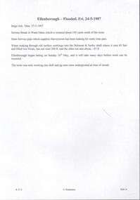
Document - DRAINAGE PROBLEMS - ELLENBOROUGH FLOODED
... leading from the steam pipe used to supply the air-compressor. It can be driven at full power with a pressure of 351bs of steam, with the engine wheel moving at the rate of 220 revolutions per minute; the battery wheel makes 850 revolutions. The plant occupies very little space. The battery is a to-light machine; that is, it can supply sufficient electricity for 35 lights...leading from the steam pipe used to supply the air-compressor. It can be driven at full power with a pressure of 351bs of steam, with the engine wheel moving at the rate of 220 revolutions per minute; the battery wheel makes 850 revolutions. The plant occupies very little space. The battery is a to-light machine; that is, it can supply sufficient electricity for 35 lights ...The Ellenborough mine was located on Snob's Hill in Eaglehawk, near Bendigo, Victoria, Australia. It was a notable mine operating on the New Chum line of reef in the Eaglehawk District. The Ellenborough Mine was the first mine in the world to use electricity to light above and underground. On 12th October 1882, the installation of the lighting system was completed by the Australian Electric Light Company. 'The whole of the levels and back have been lighted so that candles have been dispensed with ....the engine house, blacksmith''s shop and brace are also lighted at night' (Bendigo Advertiser, 13th October, 1882). 'The electricity is generated in an ordinary electric battery placed in the engine-house, and driven by a three horse power " Soho" engine. This engine is supplied with steam by a pipe leading from the steam pipe used to supply the air-compressor. It can be driven at full power with a pressure of 351bs of steam, with the engine wheel moving at the rate of 220 revolutions per minute; the battery wheel makes 850 revolutions. The plant occupies very little space. The battery is a to-light machine; that is, it can supply sufficient electricity for 35 lights. Whether there is only one light burning or 35, there is no necessity to alter the machine or the speed, and there is no danger of one light becoming too powerful because all the rest are put out. There is no danger, as many people suppose, in taking hold of the wires, even if uncovered, for the engineer last evening plainly demonstrated that where the shock was greatest it was very mild, and could hardly be felt'.Handwritten copy of a report in the Bendigo Advertiser 24/5/1907. ''Serious break in Water Main which is situated about 100 yards south of the mine. Main service pipe which supplies Harvey town has been leaking for some time past. Water soaking through old surface workings into the Belmont and Saxby shaft where it rose 60 feet and filled two x-cuts, one out west 208 ft, and the other out east about 45 ft. Ellenborough began baling on Sunday 26th May, and it will take many days before work can be resumed. The mine was only working one shift and no men were underground at time of in rush''. Document from Albert Richardson Collection of mining history.document, gold, drainage problems, ellenborough flooded, bendigo advertiser, 27/5/1907, harveytown, belmont & saxby, ellenborough, albert richardson, electricity -
 Flagstaff Hill Maritime Museum and Village
Document - Navigation Chart, Admiralty Office, Lady Bay and Warrnambool Harbour, 03/04/1871
... The chart is a historical record of structures existing in 1870; the Warrnambool Jetties, Lady Bay, the leading lights (lighthouses), streets, roads, bridges and many buildings. ...This Chart titled “Lady Bay and Warrnambool Harbour” was surveyed by Nav. Lieut. H.J. Stanley, of Britain's Royal Navy, in 1870 and printed in April 1871. The chart was made before the Warrnambool Breakwater was built (construction had begun in 1874 and was completed in 1890). The chart includes Directions for entering Lady Bay, Warrnambool Harbour. These are "Vessels entering Warrnambool Harbour must bring the Red Light in sight and steer in with it in line with the upper white Light bearing North, until the Green Light on the Jetty is opened, when steer towards it and anchor. The best anchorage is in 2 ¼ fms [fathoms)] of water, about a cable from ledge off Breakwater rock. Or where convenient, according to draught of water, only endeavouring to anchor as close as possible to Breakwater rock. It is not safe to enter or leave the Harbour in south westerly or Southerly gales.” This chart is significant for its strong connection to the maritime history of Warrnambool Harbour and Lady Bay, and eventually to the Warrnambool Breakwater. The Warrnambool Breakwater is registered as a place of significance on the Victorian Heritage Database (VHR H2024). A copy of the same chart was used to plan several submissions for future changes to the jetty and breakwater. The chart is a historical record of structures existing in 1870; the Warrnambool Jetties, Lady Bay, the leading lights (lighthouses), streets, roads, bridges and many buildings. It also shows the lay of the land and seabed.Canvas chart of Australia, South Coast, Victoria Title: Lady Bay and Warrnambool Harbour Surveyed by Nav. Lieut. H.J. Stanley, R.N., 1870. Magnet Variation, 1870 Published April 3, 1871, by the Admiralty, London. Directions for vessels entering Warrnambool Harbour are printed on the chart. The chart has a lacquer or seal over it.Top of chart has logo "HYDROGRAPHER OFFICE" "Price Eighteen Pence". "Engraved by Edward Weller" Along bottom of Chart: “London… Published at the Admiralty, 3rd April 1871, under the Superintendence of Rear Admiral G.H. Richards, F.R.S. Hydrographer, Corrections July 71” Bottom of chart “Australia South Coast Victoria Lady Bay and Warrnambool Harbour. 2494”flagstaff hill, warrnambool, chart of lady bay warrnambool 1870, warrnambool harbour, cartography, navigation, warrnambool breakwater, 1871, australia – south coast / victoria, lady bay, 1870, nav. lieut. h.j. stanley, r.n, directions for entering warrnambool harbour, hydrographer office, rear admiral g.h. richards, edward weller, port of warrnambool, flagstaff hill maritime museum & village, maritime museum, maritime village, shipwreck coast, map, chart, navigation chart, admiralty chart, breakwater, jetty, pier, vhr h2024 -
 St Kilda Historical Society
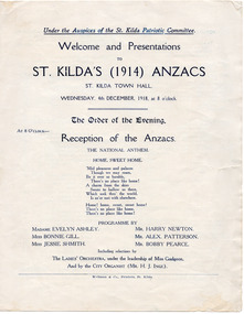
Ephemera - Flyer, Welcome and Presentations to St Kilda's (1914) Anzacs, 1918
... leading therefrom. Anzacs shields in laurel wreaths and flags were displayed along the balcony of the hall. Over the stage the word "Anzacs," outlined by electric lights, was surmounted with the words "Patriotic Committee of St. ...leading therefrom. Anzacs shields in laurel wreaths and flags were displayed along the balcony of the hall. Over the stage the word "Anzacs," outlined by electric lights, was surmounted with the words "Patriotic Committee of St. ...For welcome and presentations to St Kilda's (1914) ANZACs on 4 December 1918. The event is described by John Butler Cooper in 'The History of St Kilda' (pp 263-264) as follows: 'On Wednesday evening, December 4, 1918, seventy Anzacs of St. Kilda who had returned were welcomed by the St. Kilda Patriotic Committee at the City Hall. The hall was decorated with an immense bouquet of red, white and blue flowers, depending from the centre of the ceiling, with floral and electric festoons leading therefrom. Anzacs shields in laurel wreaths and flags were displayed along the balcony of the hall. Over the stage the word "Anzacs," outlined by electric lights, was surmounted with the words "Patriotic Committee of St. Kilda heartily Welcomes You." As the returned soldiers marched into the hall, they were received with cheers, and an electric button being touched, the word "Welcome" flashed in light caught their eyes. The Mayor presented the 1914 soldiers with gold enamelled medals, bearing the arms of St. Kilda.' White paper, single sheet folded, printed on 3 pages in blue.wwi, world war i, st kilda patriotic committee, citizens welcome to anzacs