Showing 55 items matching "loder "
-
 Eltham District Historical Society Inc
Book, A Review and Appraisal of the Diamond Creek to Ringwood Study, volume 2, working paper, by Loder and Bayly, 1979
... A Review and Appraisal of the Diamond Creek to Ringwood Study, volume 2, working paper, by Loder and Bayly...This report is a review and appraisal of the Outer Ring Road Study Diamond Creek to Ringwood prepared for The Road Planning Liaison Committee by the Joint Road Planning Group for the The City of Doncaster & Templestowe and The Shire of Eltham by Loder & Bayly Planning & Engineering Consultants. ...Loder and Bayly Planning and Engineering Consultants...A Review and Appraisal of the Diamond Creek to Ringwood Study, volume 2, working paper, by Loder and Bayly Book Loder and Bayly Planning and Engineering Consultants ...Volume 2: Working papers. This report is a review and appraisal of the Outer Ring Road Study Diamond Creek to Ringwood prepared for The Road Planning Liaison Committee by the Joint Road Planning Group for the The City of Doncaster & Templestowe and The Shire of Eltham by Loder & Bayly Planning & Engineering Consultants. "This paper attempts to set a framework for an evaluation of the recommended road link between Diamond Creek and Ringwood." Various perspectives are examined. Includes fold out maps.91 p, maps, 27 cm.melbourne ring road, roads, freeways -
 Port Melbourne Historical & Preservation Society
Document - Reports, Planning, development and traffic management, Loder & Bayly, 1974 - 1978
... 12 surveys re planning, development and traffic management carried out by Loder & Bayly, August 1974 to February 1978...Loder & Bayly...Port Melbourne Historical & Preservation Society Port Melbourne Town Hall 333 Bay Street Port Melbourne melbourne local government - city of port melbourne town planning transport - roads built environment - commercial built environment - zoning loder & bayly glen cosham 12 surveys re planning, development and traffic management carried out by Loder & Bayly, August 1974 to February 1978 Document Reports, Planning, development and traffic management Loder & Bayly ...12 surveys re planning, development and traffic management carried out by Loder & Bayly, August 1974 to February 1978local government - city of port melbourne, town planning, transport - roads, built environment - commercial, built environment - zoning, loder & bayly, glen cosham -
Box Hill Historical Society
Book, Loder and Bayly, Box Hill Mall - Submission, 1/12/1982 12:00:00 AM
... A proposal, submitted by Loder and Bayly, Planning, Engineering and Landscape Consultants, for the pedestrianisation of Main and Market Streets, Box Hill. ...Loder and Bayly...Box Hill Mall - Submission Book Loder and Bayly ...A proposal, submitted by Loder and Bayly, Planning, Engineering and Landscape Consultants, for the pedestrianisation of Main and Market Streets, Box Hill. It includes examples of their previous projects for pedestrian malls, program, team, budget and fees.glasson> don, martin> jan, safstrom> nick, read> michael, loder> john, saggers> bill, conybeare> darrel, morrison> bill, main street, market street, box hill, land use, malls, shopping centres, town planning -
 Sunshine and District Historical Society Incorporated
Document - Sunshine District Centre Structure Plan August 1985, Loder & Bayley, 31260
... Sunshine District Centre Structure Plan for the Sunshine District Centre Steering Committee by Loder & Bayley August 1985|Memo from City Planner to Councillors re: Sunshine District Centre Structure Plan dated 15th August 1985...Loder & Bayley...Part of the Gwen Goedecke Collection Sunshine District Centre Sunshine District Centre Structure Plan for the Sunshine District Centre Steering Committee by Loder & Bayley August 1985|Memo from City Planner to Councillors re: Sunshine District Centre Structure Plan dated 15th August 1985 A4 Ring bound report Document Sunshine District Centre Structure Plan August 1985 Loder & Bayley ...Part of the Gwen Goedecke CollectionSunshine District Centre Structure Plan for the Sunshine District Centre Steering Committee by Loder & Bayley August 1985|Memo from City Planner to Councillors re: Sunshine District Centre Structure Plan dated 15th August 1985sunshine district centre -
 Stawell Historical Society Inc
Photograph, Magdala-Cum-Moonlight Mine, underground at the main 1200 ft level looking North West 1902
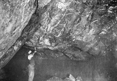
... Mining Scene Magdala-Cum-Moonlight Mine 1895. Main Lode at 1.200ft level looking North West. ...Miner underground reaching up with candle to overhead quartz lode....Stawell Historical Society Inc 46 Longfield St Stawell grampians Mining Scene Magdala-Cum-Moonlight Mine 1895. Main Lode at 1.200ft level looking North West. The Magdala Lode is a spurry mixture of Quartz Country Rock and Sulphides and was mined in bulk in large stopes as shown by photograph. ...Mining Scene Magdala-Cum-Moonlight Mine 1895. Main Lode at 1.200ft level looking North West. The Magdala Lode is a spurry mixture of Quartz Country Rock and Sulphides and was mined in bulk in large stopes as shown by photograph.Miner underground reaching up with candle to overhead quartz lode.stawell mining -
 Sunshine and District Historical Society Incorporated
Document - Sunshine District Centre Traffic Study 1983, 30651
... A binded A4 report for the Sunshine District Centre Liaison Committee, prepared by Loder & Bayly, convened by the Melbourne and Metropolitan Board of Works, on December 1983. ...Sunshine District Centre Traffic Study 1983 Loder & Bayly 1983...Sunshine District Centre Sunshine District Centre Traffic Study 1983 Loder & Bayly 1983 A binded A4 report for the Sunshine District Centre Liaison Committee, prepared by Loder & Bayly, convened by the Melbourne and Metropolitan Board of Works, on December 1983. ...Sunshine District Centre Traffic Study 1983 Loder & Bayly 1983sunshine district centre -
 Greensborough Historical Society
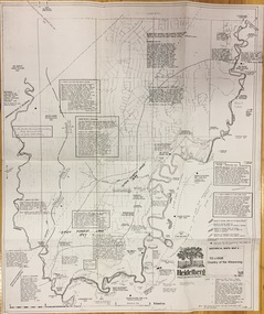
Map, Heidelberg: Historic River Landscape Assessment. Historical Maps. Map B 1838-1851, "The Distinctly aristocratic locality", 1985c
... Loder & Bayley...Loder & Bayley...Map B 1838-1851, "The Distinctly aristocratic locality" Map Loder & Bayley Loder & Bayley ...Geographical area of around 35 sq. kilometres marked with physical features such as major roads, rivers, vegetation and properties, with contemporary notes on landowners, descriptions and comments on the land and its development. Bounded by Shire of Diamond Valley to the North, Darebin Creek to the West and Plenty River to the EastBlack and white sketch map on white paperheidelberg, heidelberg - maps -
 Greensborough Historical Society
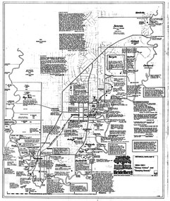
Map, Heidelberg. Historic River Landscape Assessment. Historical maps: Map C 1851-1863. "The Garden of the colony", 1985c
... Loder & Bayley...Loder & Bayley..."The Garden of the colony" Map Loder & Bayley Loder & Bayley ...Geographical area of around 35 sq. kilometres marked with physical features such as major roads, vegetation and properties, with locations and notes of the increasing number of farms, gardens orchards and vineyards which had become established in addition to pastoral runs. Bounded by Shire of Diamond Valley to the North, Darebin Creek to the West and Plenty River to the East.Black and white sketch map on white paperheidelberg, heidelberg - maps -
 Greensborough Historical Society
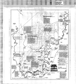
Map, Heidelberg: Historic River Landscape Assessment. Historical maps. Map D 1864 -1901 "Sleepy Hollow" and "Sleeping beauty", 1985c
... Loder & Bayley...Loder & Bayley...Map D 1864 -1901 "Sleepy Hollow" and "Sleeping beauty" Map Loder & Bayley Loder & Bayley ...Geographical area of c. 35 sq. kilometres marked with physical features such as major roads, rivers, vegetation and properties, with locations and notes on the increasing number of farms, orchards and vineyards that had been developed in addition to pastoral runs. Bounded by Shire of Diamond Valley to the North, Darebin Creek to the West, and Plenty River to the East.Black and white sketch on white paper. Second copy 600 x 430 cm printed in black on semi-opaque paperheidelberg, heidelberg - maps -
 Greensborough Historical Society
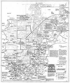
Map, Heidelberg: Historic River Landscape Assessment. Historical maps. Map E 1901-1934 "A Time of projects and improvements", 1985c
... Loder & Bayley...Loder & Bayley...Map E 1901-1934 "A Time of projects and improvements" Map Loder & Bayley Loder & Bayley ...Geographical area of around 35 sq. kilometres marked with physical features such as major roads, railways (new extension to Eltham), rivers and properties, also housing sub-divisions and community facilities such as hospitals, parks and sporting reserves and indications of new small scale industries such as dairying. Bounded by Shire of Diamond Valley to the North, Darebin Creek to the West and Plenty River to the East. Black and white sketch map on white paperheidelberg, heidelberg - maps -
 Greensborough Historical Society
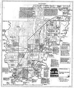
Poster - Map, Heidelberg: Historic River Landscape Assessment, Historical Maps. Map A To 1838. Country of the Wawarang, 1985c
... Loder & Bayley...Loder & Bayley...Country of the Wawarang Poster Map Loder & Bayley Loder & Bayley ...Geographical area of around 35 sq. kilometres marked with physical features such as major roads, rivers, vegetation and properties, with contemporary notes on landowners, descriptions and comments on the land and its development. Bounded by Shire of Diamond Valley to the North, Darebin Creek to the West and Plenty River to the East.Black an white sketch map on white paperheidelberg, heidelberg - maps -
 Sunshine and District Historical Society Incorporated
Document - Sunshine Shopping Survey - A Report to the Sunshine City Council, Loder and Bayly Consulting Engineers and Planners, 26481
... Loder and Bayly Consulting Engineers and Planners...Document Sunshine Shopping Survey - A Report to the Sunshine City Council Loder and Bayly Consulting Engineers and Planners ...sunshine shopping, city of sunshine -
 Sunshine and District Historical Society Incorporated
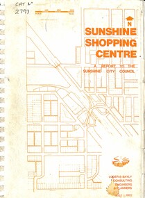
Document - Sunshine Shopping Centre - A Report to the Sunshine City Council, Loder & Bayly Consulting Engineers & Planners, 26481
... Loder & Bayly Consulting Engineers & Planners...Sunshine Shopping Center Sunshine Shopping Centre - A Report to the Sunshine City Council Ring bound document Document Sunshine Shopping Centre - A Report to the Sunshine City Council Loder & Bayly Consulting Engineers & Planners ...Sunshine Shopping Centre - A Report to the Sunshine City Councilsunshine shopping center -
Box Hill Historical Society
Book, Loder and Bayly Pty. Ltd, Box Hill Bicycle Strategy Plan, 1/05/1988 12:00:00 AM
... Loder and Bayly Pty. Ltd....Box Hill Bicycle Strategy Plan Book Loder and Bayly Pty. Ltd. ...Report on provision of improved cycling conditions and cycling behaviour in Box Hill. It includes route descriptions.box hill, burwood, balwyn, surrey hills, blackburn, koonung creek, bicycle paths, bennettswood, gardiners creek, kerrimuir, recreation, engineering, thurston street, station street -
 Kew Historical Society Inc
Plan, Loder & Bayly, Heidelberg: Historic River Landscape Assessment, 1982
... Loder & Bayly...Heidelberg: Historic River Landscape Assessment Plan Loder & Bayly ...Gwen McWilliam is well known as an authority on the history of Boroondara and the author of a large number of books and pamphlets about the City. She was awarded the medal of the Order of Australia in 2001 ‘for service to the community of Hawthorn and district, particularly through the research, documentation and publication of its history.’ This map from her collection was donated to the Kew Historical SocietyPlan of Heidelberg, annotated with details about the occupancy pre and post European settlement. The plan also contains geological references. The plan is included and analysed in volume 2 of the Heidelberg Conservation Study (1985). The original plan was published created in 1982. Printed annotationscity of heidelberg, yarra valley, historic plans -- heidelberg -
 Wodonga & District Historical Society Inc
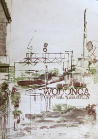
Book - Wodonga Central Area Study, Loder and Bayly, Planning & Engineering Consultants, March 1975
... Loder and Bayly, Planning & Engineering Consultants...Wodonga Central Area Study Book Wodonga Central Area Study Loder and Bayly, Planning & Engineering Consultants ...This report was the result of an investigation into the potential future development and town planning for the central area of Wodonga. Chapters of the final report are:- Chapter 1: Summary: Conclusions and Recommendations, Chapter 2: Setting the scene, Chapter 3: Possible futures, Chapter 4: Objectives, Chapter 5: Growth Options, Chapter 6: Recommended approaches, Chapter 7: Plan elements and Chapter 8: Ways and Means.A report of 134 pages, including illustrations and maps. The report was presented to the Albury-Wodonga Development Corporation and the Rural City of Wodonga.This report was the result of an investigation into the potential future development and town planning for the central area of Wodonga. Chapters of the final report are:- Chapter 1: Summary: Conclusions and Recommendations, Chapter 2: Setting the scene, Chapter 3: Possible futures, Chapter 4: Objectives, Chapter 5: Growth Options, Chapter 6: Recommended approaches, Chapter 7: Plan elements and Chapter 8: Ways and Means.wodonga town planning, albury-wodonga development, rural city of wodonga -
 Sunshine and District Historical Society Incorporated
Document - Employment And Industry Study Western Metropolitan Region Summary Of Findings Report, Plant Location International (Australia) Pty Ltd, September 1976
... ...Loder & Bayley...City of Sunshine Alexander "Alex" George Gillon Employment And Industry Study Western Metropolitan Region Melbourne Summary of Findings For Western Region Commission Sampled paper report Document Employment And Industry Study Western Metropolitan Region Summary Of Findings Report Plant Location International (Australia) Pty Ltd Loder & Bayley ...Employment And Industry Study Western Metropolitan Region Melbourne Summary of Findings For Western Region Commission city of sunshine, alexander "alex" george gillon -
 Wodonga & District Historical Society Inc
Book - Wodonga Central Area Study 1989, Loder and Bayly, Planning & Engineering Consultants, 1989
... Loder and Bayly, Planning & Engineering Consultants...Wodonga Central Area Study 1989 Book Wodonga Central Area Study 1989 Loder and Bayly, Planning & Engineering Consultants ...This report was the result of an investigation into the potential future development and planning for commercial areas in Wodonga. Chapters of the final report are:- Chapter 1: Summary and Recommendations, Chapter 2: Wodonga Centre and its retail functioning, Chapter 3: Growth, Change and the need for a strategy, Chapter 4: Building a strategy for the Centre, Chapter 5: Components of a regional strategy, Chapter 6: A retail structure within Wodonga, Chapter 7: Future Road networks, Chapter 8: An urban design framework, Chapter 9: An overview of the emerging structure, Chapter 10: Planning scheme provisions and Chapter 11 Appendice (refer separate reports).A report of 134 pages, including illustrations and maps. The report was presented to the Albury-Wodonga Development Corporation and the Rural City of Wodonga.non-fictionThis report was the result of an investigation into the potential future development and planning for commercial areas in Wodonga. Chapters of the final report are:- Chapter 1: Summary and Recommendations, Chapter 2: Wodonga Centre and its retail functioning, Chapter 3: Growth, Change and the need for a strategy, Chapter 4: Building a strategy for the Centre, Chapter 5: Components of a regional strategy, Chapter 6: A retail structure within Wodonga, Chapter 7: Future Road networks, Chapter 8: An urban design framework, Chapter 9: An overview of the emerging structure, Chapter 10: Planning scheme provisions and Chapter 11 Appendice (refer separate reports).wodonga development planning, albury wodonga development -
 Federation University Historical Collection
Book, Mines and Minerals: A Guide for the Australian Miner, 1885
... Chapters in the book include Geology; Rocks and their Movements; Stratified Deposits; Mineral Veins and Lodes; Dynamics of Lodes; Filling of Lodes; Irregular Deposits; Alluvial Deposits; Physical Properties of Minerals; Compsition and Determination of Minerals; Noble Mineral; Silver and Lead; Quicksilver or Mercury; Haloids and salts; Quartz and Opal; Precious stones; assays and the use of Blowpipes; Special Assays for Gold and Silver...Chapters in the book include Geology; Rocks and their Movements; Stratified Deposits; Mineral Veins and Lodes; Dynamics of Lodes; Filling of Lodes; Irregular Deposits; Alluvial Deposits; Physical Properties of Minerals; Compsition and Determination of Minerals; Noble Mineral; Silver and Lead; Quicksilver or Mercury; Haloids and salts; Quartz and Opal; Precious stones; assays and the use of Blowpipes; Special Assays for Gold and Silver Mines and Minerals: A Guide for the Australian Miner Book S. ...This book was presented to Professor Ferdinand Krause of the Ballarat School of Mines by the co-author Felix Ratte who had taught Geology at the Ballarat School of Mines. Felix Ratte became mineralogist to the Australian Museum, Sydney.Hardcovered book with brown cloth cover. 341 pages with illustrations. Chapters in the book include Geology; Rocks and their Movements; Stratified Deposits; Mineral Veins and Lodes; Dynamics of Lodes; Filling of Lodes; Irregular Deposits; Alluvial Deposits; Physical Properties of Minerals; Compsition and Determination of Minerals; Noble Mineral; Silver and Lead; Quicksilver or Mercury; Haloids and salts; Quartz and Opal; Precious stones; assays and the use of Blowpipes; Special Assays for Gold and SilverFrontise page handwritten in ink: 'Prof. Krause from F. Ratte'mining, ballarat school of mines, geology, felix ratte, minerals, ferdinand krause -
 Federation University Historical Collection
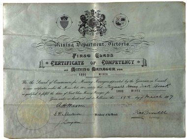
Certificate, Mining Department of Victoria First Class Certificate of Competency as Mining Manager for Lode Mines, 1907, 19/03/1907
... Mining Department of Victoria First Class Certificate of Competency as Mining Manager for Lode Mines, 1907...Mining Department of Victoria First Class Certificate of Competency as Mining Manager for Lode Mines made out to Reginald Henry Brook. ...Mining Department of Victoria First Class Certificate of Competency as Mining Manager for Lode Mines, 1907 Certificate ...Mining Department of Victoria First Class Certificate of Competency as Mining Manager for Lode Mines made out to Reginald Henry Brook. mining department victoria, mining alumni, alumni, mine management, reginald brook, a.h. merrin, j. langdon, r. birrell -
 Sunshine and District Historical Society Incorporated
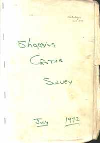
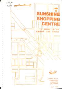
Document - Sunshine Shopping Centre A Report to the Sunshine City Council, 26481
... A binded A4 report for the Sunshine City Council, prepared by Loder & Bayly, on July 1972. The report details planning proposals for the future use and development of the Sunshine Shopping Centre....Sunshine Shopping Centre A binded A4 report for the Sunshine City Council, prepared by Loder & Bayly, on July 1972. The report details planning proposals for the future use and development of the Sunshine Shopping Centre. ...sunshine shopping centre -
 Bendigo Historical Society Inc.
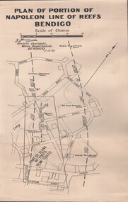
Document - MCCOLL, RANKIN AND STANISTREET COLLECTION: NAPOLEON REEF GOLD MINING CO. N.L, 5 December 1939
... Document: 4 Copies of plans showing part of lease No. 10970 (was 10873) and Central Napoleon Lode Channel, prepared by J.J. Caldwell District Geologist, Mines Dept, Bendigo 5th Dec 1939....History House 11 Mackenzie Street Bendigo goldfields ORGANIZATION Business industrial - mining McColl Rankin & Stanistreet mining gold mining Napoleon Reef Document: 4 Copies of plans showing part of lease No. 10970 (was 10873) and Central Napoleon Lode Channel, prepared by J.J. Caldwell District Geologist, Mines Dept, Bendigo 5th Dec 1939. ...Document: 4 Copies of plans showing part of lease No. 10970 (was 10873) and Central Napoleon Lode Channel, prepared by J.J. Caldwell District Geologist, Mines Dept, Bendigo 5th Dec 1939.organization, business, industrial - mining, mccoll rankin & stanistreet, mining, gold mining, napoleon reef -
 Stawell Historical Society Inc
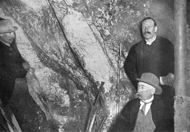
Photograph, "Amalgamated Scotchmans" Underground Mine with the face at the 1100 ft level & 3 men inspecting the Quartz Reef
... Illustrated the Magdala Lode appearance....Illustrated the Magdala Lode appearance. Stawell Mining Three men underground inspecting mine face. ...Three men inspecting Quartz reef in Amalgamated Scotchmans Underground Mine 1895. Showing the face of the 1.100ft level. Illustrated the Magdala Lode appearance.Three men underground inspecting mine face. Obviously not miners.stawell mining -
Bendigo Historical Society Inc.
Photograph - KEN BICE COLLECTION: CENTRAL DEBORAH MINE
... On back trucking ore in intermediate level below 1270 ft. on Rowe's lode, Central Deborah Gold Mine, Bendigo, 1952. ...On back trucking ore in intermediate level below 1270 ft. on Rowe's lode, Central Deborah Gold Mine, Bendigo, 1952. ...Copy of photo: man pushing ore cart. Poor quality image. On back trucking ore in intermediate level below 1270 ft. on Rowe's lode, Central Deborah Gold Mine, Bendigo, 1952. This is a digital only photograph.bendigo, mining, central deborah mine, bendigo, central deborah mine, ore truck, mining, miners -
 Greensborough Historical Society
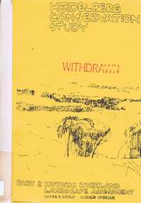
Book, Heidelberg Conservation Study: Part 2: Historic Riverland Landscape Assessment. Revised 1987, 1987_
... Report prepared by Loder and Bayly and Marilyn McBriar on behalf of City of Heidelberg and Heidelberg Heritage Advisory Committee. ...Greensborough Historical Society 34A Glenauburn Road Lower Plenty Lower Plenty melbourne Report prepared by Loder and Bayly and Marilyn McBriar on behalf of City of Heidelberg and Heidelberg Heritage Advisory Committee. ...Report prepared by Loder and Bayly and Marilyn McBriar on behalf of City of Heidelberg and Heidelberg Heritage Advisory Committee. Area covered is from Darebin Parklands in the south to Plenty River at Yallambie in the north. Revised 1987.This study identifies neighbourhood character, documents past development and the capacity of the environment for future development with particular emphasis on the river precincts - Plenty River, Yarra River and Darebin Creek.Part three of set of three books. Paperback, 333 pages, Illus., maps. 2 copies.Stamps: Yarra Plenty Regional Library Service, and, Withdrawnheidelberg, macleod, heidelberg heritage advisory committee, marilyn mcbriar, plenty river, yarra river, darebin creek -
 Stawell Historical Society Inc
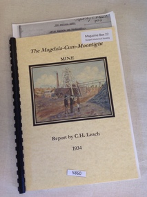
Book, C.H. Leach, The Magdala-Cum-Moonlight Mine, 1934
... The Report is intended to summarise and place on record the information recently collected regarding the Magdal Lode, with the object of correlating the Northern, or more extensive developed portion, underlying the southern extremity of the big Hill. ...Stawell Historical Society Inc 46 Longfield St Stawell grampians The Report is intended to summarise and place on record the information recently collected regarding the Magdal Lode, with the object of correlating the Northern, or more extensive developed portion, underlying the southern extremity of the big Hill. ...The Report is intended to summarise and place on record the information recently collected regarding the Magdal Lode, with the object of correlating the Northern, or more extensive developed portion, underlying the southern extremity of the big Hill. Report by C.H. LeachYellow card front and rear cover. front cover has a Picture by Ian Hollwell of three men standing in front of a Poppet head and chimneyThe Magadala-Cum-Moonlight Report by C.H. Leachstawell gold mining -
Bendigo Historical Society Inc.
Photograph - KEN BICE COLLECTION: CENTRAL DEBORAH MINE
... On back Geoff Rigbye trucking from a chute on western leg of Rowe's lode 1190 ft. level Central Deborah Mine, Bendigo, 1952. ...On back Geoff Rigbye trucking from a chute on western leg of Rowe's lode 1190 ft. level Central Deborah Mine, Bendigo, 1952. ...Copy of photograph: image shows man filling ore truck, underground. On back Geoff Rigbye trucking from a chute on western leg of Rowe's lode 1190 ft. level Central Deborah Mine, Bendigo, 1952. This is a digital only photograph.bendigo, mining, central deborah mine, bendigo, central deborah mine, rowe's lode, rigbye, mining -
Lakes Entrance Historical Society
Book, Enever, Jim, Journal of Australian Mining. Vol 19, 2012
... A well researched account, gleaned from available sources, concerning the search for elusive silver/lead ore lode in the Buchan area of East Gippsland. ...Lakes Entrance Historical Society 4 Marine Parade Lakes Entrance gippsland Mines and Mining A well researched account, gleaned from available sources, concerning the search for elusive silver/lead ore lode in the Buchan area of East Gippsland. ...A well researched account, gleaned from available sources, concerning the search for elusive silver/lead ore lode in the Buchan area of East Gippsland. From the 1870's to the early 1890's a few companies were formed. This article refers in particular tomines and mining -
 Bendigo Historical Society Inc.
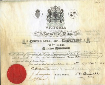
Document - ALMOND ROWE WILLIAMS COLLECTION: FIRST CLASS MINING MANAGER CERTIFICATE (COPY)
... Nature of previous experience - 21 years in lode mines. 'Granted without examination upon a mining manager's certificate issued by the Bendigo School of Mines'...Nature of previous experience - 21 years in lode mines. 'Granted without examination upon a mining manager's certificate issued by the Bendigo School of Mines' Document ALMOND ROWE WILLIAMS COLLECTION: FIRST CLASS MINING MANAGER CERTIFICATE (COPY) ...Copy of Certificate of Competency, First Class Mining Manager, issued to Almond Rowe Williams, 1914. On back of certificate: ' number of certificate 67, place of birth Bendigo 5th July 1871. Nature of previous experience - 21 years in lode mines. 'Granted without examination upon a mining manager's certificate issued by the Bendigo School of Mines'bendigo, mining, almond rowe williams -
 Federation University Historical Collection
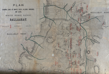
Plan, White Horse Range Ballarat, 1885, 06/1885
... Quartz reefs include: Yorkshire, Try Again, Promised Land, Western Slates, Norwegian, Robert's Lode, Finn's, Band and albion, Rothschild, Old Post Office, Queen Lode. ...Quartz reefs include: Yorkshire, Try Again, Promised Land, Western Slates, Norwegian, Robert's Lode, Finn's, Band and albion, Rothschild, Old Post Office, Queen Lode. ...Two plans .1) Plan of the Ballarat Goldfields showing leads, rivers, streets and topography. Quartz reefs include: Yorkshire, Try Again, Promised Land, Western Slates, Norwegian, Robert's Lode, Finn's, Band and albion, Rothschild, Old Post Office, Queen Lode. Leads include: Navy jacks, Gays, Canadian, Prince Regent, Sailors Gully, White Horse, Little White Horse, Milkmans, Nightingale, Golden Point, Gravel Pits. Scale is 8 Chains to 1 inch .2) Plan showing lines of quartz reefs, alluvial workings and leads, White Horse Range, Ballarat. Leads include White Horse LEad, Little White Horse Lead, One Eye Gully, Terrible Lead, Sailor's Gully, Canadian Lead, Prince Regent Gully, Canadian Lead, Cavs Lead, Navy jacks Lead, Eureka Lead, Old Gravel Pits Lead, Gravel Pits Lead, Nightingale Lead, Malakoff Lead, Milkmans Lead, Redan Lead, Woolshed Lead, Jacksons Lead, Winters Lead, SCtochman's Lead, Canadian Lead. Reefs include: Promised Land, Daniash, Sir Garnet Wolsley, Norwegian, Rothschile, Band and Albion, Finns, Llanberis, Roberts Lode, Tynworths and Black Hill, Oregan, Yorkshire, Try Again, Yorkshire, Post Office, Clarke's, Western Slates, Black Slate, Danks Slates, Eastern Slates, Queen's Lode, Fire Brigade. Mines include Red Streak, New Chum, Tinworths, Woah Hawp, Normanby, Speedwell, Llanberris Extended, Llanberis, Last Chance, Major, Countess, Pioneer and a number of batteries along Main Road Hills include: Mount Clear, Pennyweight Hill, Sovereign Hillballarat, plan, white horse range, white horse, goldfields, mines, reefs, indicators, leigh river, cgt, tinworth, mining