Showing 200 items matching "main highway"
-
 Mt Dandenong & District Historical Society Inc.
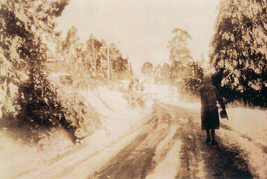
Photograph, Miss Perriman on Main Highway, Kalorama 1931, c1930
... Miss Perriman on Main Highway, Kalorama 1931.......Main Highway...Back view of Miss Perriman walking along the Main Highway, Kalorama, in the snow in 1931....Miss Perriman on Main Highway, Kalorama 1931. Photograph ...Back view of Miss Perriman walking along the Main Highway, Kalorama, in the snow in 1931.kalorama, snow, main highway, perriman -
 Chelsea & District Historical Society Inc
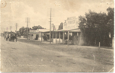
Photograph - Main Road (now Nepean Highway) Chelsea, c 1915
... Main Road (now Nepean Highway) Chelsea...Black and white postcard of the main road, Chelsea (now Nepean Highway) showing P. Mayer's Store and Bishop's Store. ...Photograph Main Road (now Nepean Highway) Chelsea ...Black and white postcard of the main road, Chelsea (now Nepean Highway) showing P. Mayer's Store and Bishop's Store. Bishop's store is on the corner of Wimbourne Avenue, Chelsea. The road is unmade and two wagons are traveling down the road.Frankston Road, Chelseachelsea, mr p. mayer, mr bishop, wagons -
 Clunes Museum
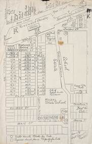
Map
... SCALE 20 CHAINS TO 1 INCH. MAIN HIGHWAYS NAMED. NO STREET NAMES...SCALE 20 CHAINS TO 1 INCH. MAIN HIGHWAYS NAMED. NO STREET NAMES Map MAP ...A MAP OF THE BOROUGH OF CLUNES. SCALE 20 CHAINS TO 1 INCH. MAIN HIGHWAYS NAMED. NO STREET NAMESdocument maps, borough of clunes map -
 Mt Dandenong & District Historical Society Inc.
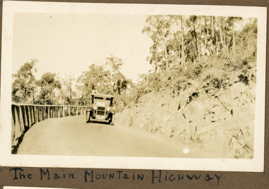
Photograph
... Below photograph in album: The Main Mountain Highway...Main Road CRB Road Mt Dandenong Tourist Road car automobile Ivy Child Kalorama Below photograph in album: The Main Mountain Highway Sepia coloured photograph showing an old car rounding a bend in the road. ...The photograph shows an old car rounding a bend on what is now the Mt Dandenong Tourist Road. Around 1930 it would have been called the CRB Road or the Main Road. The photograph is in the Ivy Child Album. Ivy May Child (1910 – 1989) was the daughter of Arthur Edward (Ted) Child (1878 – 1964) and Ethel May Madden (1888 – 1970). Ted Child was the son of Matthew Francis Child (1839 – 1933) and Martha Jeeves (1857 – 1926). He was the grandson of one of the early pioneers Francis Child. Ivy grew up on the family property on Childs Road and took many photographs. Most of these are glued into her photo album. The album covered the years from c1927 – 1932. Ivy married Henry William Burgess (1906 – 1968) in 1944.Sepia coloured photograph showing an old car rounding a bend in the road.Below photograph in album: The Main Mountain Highwaymain road, crb road mt dandenong tourist road, car, automobile, ivy child, kalorama -
 Ballarat Tramway Museum
Photograph - Black & White - Tram 21 Victoria St, Keith Kings, 16/3/1962
... The photographs shows the arrangement for trams in Victoria St, the former main highway between Melbourne and Adelaide....The photographs shows the arrangement for trams in Victoria St, the former main highway between Melbourne and Adelaide. Yields information about Ballarat tram No. 21 in Victoria St and the street itself. ballarat victoria st tram 21 trams tramways On rear has the photographers file number O(l)(18) Black and White photograph of SEC Ballarat tram 21 in Victoria, in bound to the City. ...The photographs shows the arrangement for trams in Victoria St, the former main highway between Melbourne and Adelaide.Yields information about Ballarat tram No. 21 in Victoria St and the street itself.Black and White photograph of SEC Ballarat tram 21 in Victoria, in bound to the City. Photo by Keith Kings, 16/3/1963.On rear has the photographers file number O(l)(18)ballarat, victoria st, tram 21, trams, tramways -
Lakes Entrance Historical Society
Map - Township of Manorina Parish of Jilwain County of Croajingolong, Department of Lands and Survey, 1967
... Shows allotments some with landowners, Princes Highway, Main Road Shire of Orbost...Landowners Roads and Streets Township Shows allotments some with landowners, Princes Highway, Main Road Shire of Orbost Map Township of Manorina Parish of Jilwain County of Croajingolong Department of Lands and Survey ...Shows allotments some with landowners, Princes Highway, Main Road Shire of Orbostlandowners, roads and streets, township -
 Ringwood and District Historical Society
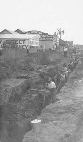
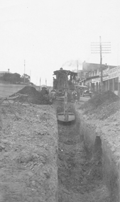
Photograph, Maroondah Highway East, Ringwood- c1920's. Excavation for new water main
... Maroondah Highway East, Ringwood- c1920's. Excavation for new water main....Written on rear of backing sheet: "Digging trench for water main along Maroondah Highway."...Ringwood and District Historical Society 125A Warrandyte Road Ringwood North melbourne Written on rear of backing sheet: "Digging trench for water main along Maroondah Highway." Black and white photograph (2 copies- 1 large, 1 small) Maroondah Highway East, Ringwood- c1920's. ...Black and white photograph (2 copies- 1 large, 1 small)Written on rear of backing sheet: "Digging trench for water main along Maroondah Highway." -
 Ballarat Tramway Museum
Slide - 35mm slide/s, Ben Parle, 8/04/1958 12:00:00 AM
... Note the lack of a centre line along the main highway. ...Note the lack of a centre line along the main highway. Slide 35mm slide/s Ben Parle ...Kodachrome Transparency - 35mm slide - cardboard mount, with one side with red border and words "Kodachrome Transparency / Processed by Kodak" top and bottom. Photo taken by Ben Parle 8/4/1958, date stamped onto slide. Has slide No. "13" stamped in red in top corner. Photo of Ballarat 30, outbound along Sturt St. West, opposite the City Oval. Note the lack of a centre line along the main highway. "Sturt St West" / "8-4-58"tramways, trams, sturt st west, western highway, tram 30 -
 Bendigo Historical Society Inc.
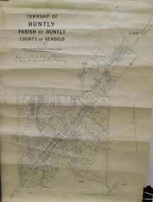
Map - JACK FLYNN COLLECTION: HUNTLY, 12.03.1932
... Western and South Riding Division on Main St. (Main Northern Highway) - written in ink below name of map....Western and South Riding Division on Main St. (Main Northern Highway) - written in ink below name of map. ...Map: Township of Huntly, Parish of Huntly , County of Bendigo. Parish plan. Western and South Riding Division on Main St. (Main Northern Highway) - written in ink below name of map.BY Authority H.J. Green. Photo-Lithographed at the Dept., of Lands and Survey, Melbourne. 12.3.32map, bendigo, township, huntly -
 Ballarat Tramway Museum
Slide - 35mm slide/s, Ben Parle, 8/04/1958 12:00:00 AM
... Note the lack of a centre line along the main highway. ...Note the lack of a centre line along the main highway. Slide 35mm slide/s Ben Parle ...Kodachrome Transparency - 35mm slide - cardboard mount, with one side with red border and words "Kodachrome Transparency / Processed by Kodak" top and bottom. Photo taken by Ben Parle 8/4/1958, date stamped onto slide. Has slide No. "14" stamped in red in top corner. Photo of Ballarat 30 (assumed on basis of Reg. Item 2885), outbound along Sturt St. West. Note the lack of a centre line along the main highway. "Sturt St West" / "8-4-58"tramways, trams, sturt st west, western highway, tram 30 -
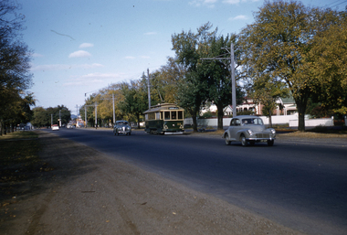
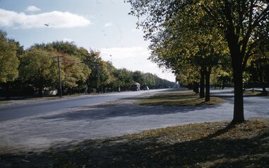
 City of Ballarat Libraries
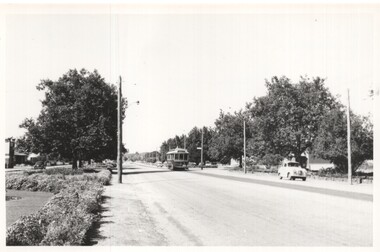
35mm Slide, Sturt Street West, Ballarat circa late 1950s
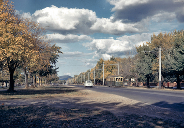
... Just a tram and an early Holden, yet at the time of this photograph, this was the main highway through to Adelaide. Mrs Bon Strange and her husband Bert were well known Ballarat residents. ...Just a tram and an early Holden, yet at the time of this photograph, this was the main highway through to Adelaide. Mrs Bon Strange and her husband Bert were well known Ballarat residents. ...A lovely shot of the western end of Sturt Street, looking east to Mt Warrenheip. Not much traffic today! Just a tram and an early Holden, yet at the time of this photograph, this was the main highway through to Adelaide. Mrs Bon Strange and her husband Bert were well known Ballarat residents. When Mrs Strange died some years ago, her extensive slide collection was sorted through and those relevant to Ballarat were gifted to the Ballarat Library.sturt street, trams -
 Ballarat Tramway Museum
Slide - 35mm slide/s, Ben Parle, 5/04/1958 12:00:00 AM
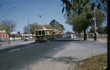
... Passengers are walking across to the service car - note the level of traffic on the main highway to Melbourne. Group of AETA travellers standing on the right hand side of the photo. ...Passengers are walking across to the service car - note the level of traffic on the main highway to Melbourne. Group of AETA travellers standing on the right hand side of the photo. ...Kodachrome Transparency - 35mm slide - cardboard mount, with one side with red border and words "Kodachrome Transparency / Processed by Kodak" top and bottom. Photo taken by Ben Parle 5/4/1958. Has slide No. "16" stamped in red in top corner. Photo of the No. 41 and 21 at the Victoria St terminus, with another single truck tram behind. No. 21 has destination of Special. Both trams are carrying the AETA special car auxiliary signs. Passengers are walking across to the service car - note the level of traffic on the main highway to Melbourne. Group of AETA travellers standing on the right hand side of the photo. Meagher's Hotel can be seen on the left hand side. Note the tram stop signage at the terminus. For high resolution scan see btm2849h.tif"Victoria St line" "5-4-58"tramways, trams, victoria st, aeta, tram 21, tram 41 -
 Ringwood and District Historical Society
Photograph, Maroondah Highway Central, Ringwood. Laying water main in Main Street, 1935. Looking towards the east
... Maroondah Highway Central, Ringwood. Laying water main in Main Street, 1935. ...Image shows excavator digging trench for water main on Main Road (Maroondah Highway. Towards the north-east, near the corner of Warrandyte Road. ...Ringwood and District Historical Society 125A Warrandyte Road Ringwood North melbourne Image shows excavator digging trench for water main on Main Road (Maroondah Highway. Towards the north-east, near the corner of Warrandyte Road. ...Black and white photographImage shows excavator digging trench for water main on Main Road (Maroondah Highway. Towards the north-east, near the corner of Warrandyte Road. Bently's timber yard and Pratt's butcher. -
 Ringwood and District Historical Society
Photograph, Maroondah Highway Central, Ringwood. Laying water main in Main Street, 1935
... Maroondah Highway Central, Ringwood. Laying water main in Main Street, 1935....Image shows excavator digging trench for water main on Main Road (Maroondah Highway. Towards the west, near the corner of Warrandyte Road. ...Ringwood and District Historical Society 125A Warrandyte Road Ringwood North melbourne Image shows excavator digging trench for water main on Main Road (Maroondah Highway. Towards the west, near the corner of Warrandyte Road. ...Black and white photographImage shows excavator digging trench for water main on Main Road (Maroondah Highway. Towards the west, near the corner of Warrandyte Road. The Ringwood Stationmaster's house is on the left, Bamford's timber yard, Coffee Palace and other shops on right. -
 Bayside Gallery - Bayside City Council Art & Heritage Collection
Photograph, Department of Crown Lands and Survey, Victoria, Brighton, Brighton East and Bentleigh, c. 1965-71
... The significant landmark featured is Dendy Park, on the corner of Dendy Street and Nepean Highway. The main roads shown include Centre Road at the top, Nepean Highway diagonally across the photograph and South Road at the bottom....The significant landmark featured is Dendy Park, on the corner of Dendy Street and Nepean Highway. The main roads shown include Centre Road at the top, Nepean Highway diagonally across the photograph and South Road at the bottom. ...The Department of Crown Lands and Survey (1857-1983) was responsible for the administration of survey and mapping and the sale, occupation and management of crown land throughout its existence. This aerial photograph shows parts of Brighton, Brighton East and Bentleigh and was taken circa 1965-71.brighton, department of crown lands and survey, aerial photograph, bayside, port phillip bay, map, cartographic material, bentleigh, brighton east, dendy park, dendy street, centre road, nepean highway, south road, football -
 Bendigo Historical Society Inc.
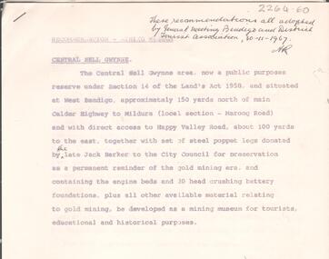
Document - ALBERT RICHARDSON COLLECTION: CENTRAL NELL GWYNNE RECOMMENDATIONS FOR MINING MUSEUM
... Written on top right of typed document: 'These recommendations all adopted by General Meeting Bendigo and District Tourist Association, 30.11.1967' Document describes the 'Central Nell Gwynne area, situated at West Bendigo, approximately 150 yards north of main Calder Highway to Mildura, local section Marong Road, which is a public purposes reserve under Section 14 of the Land's Act 1958. ...Written on top right of typed document: 'These recommendations all adopted by General Meeting Bendigo and District Tourist Association, 30.11.1967' Document describes the 'Central Nell Gwynne area, situated at West Bendigo, approximately 150 yards north of main Calder Highway to Mildura, local section Marong Road, which is a public purposes reserve under Section 14 of the Land's Act 1958. ...Six page typed document, signed by Albert Richardson, and a handwritten copy of same. Written on top right of typed document: 'These recommendations all adopted by General Meeting Bendigo and District Tourist Association, 30.11.1967' Document describes the 'Central Nell Gwynne area, situated at West Bendigo, approximately 150 yards north of main Calder Highway to Mildura, local section Marong Road, which is a public purposes reserve under Section 14 of the Land's Act 1958. The steel poppet legs donated by the late Jack Barker to the City Council for preservation be a permanent reminder of the gold mining era and containing the engine beds and 20 head crushing battery foundation, be developed as a mining museum for tourists, educational and historical purposes'bendigo, mining, central nell gwynne -
Bendigo Historical Society Inc.
Map - CAMPBELL COLLECTION: BENDIGO AND DISTRICT MAPS
... Bendigo Whipstick Forest Park, 1:75,000, reserved forest and crown land, highway main road access forest tracks. New Moon Mine, Elliot Dam, Nuggety Dam, Rogers Tree, Old Tom Mine, Blow Holes, Skylark Dam, Monument Rock, Hartland Eucalyptus Still and Dam, Hartland Eucalyptus Farm, Millwood Dam, Sandner Eucalyptus Still Site, Various unmarked dams. ...Bendigo Whipstick Forest Park, 1:75,000, reserved forest and crown land, highway main road access forest tracks. New Moon Mine, Elliot Dam, Nuggety Dam, Rogers Tree, Old Tom Mine, Blow Holes, Skylark Dam, Monument Rock, Hartland Eucalyptus Still and Dam, Hartland Eucalyptus Farm, Millwood Dam, Sandner Eucalyptus Still Site, Various unmarked dams. ...Map. Bendigo Whipstick Forest Park, 1:75,000, reserved forest and crown land, highway main road access forest tracks. New Moon Mine, Elliot Dam, Nuggety Dam, Rogers Tree, Old Tom Mine, Blow Holes, Skylark Dam, Monument Rock, Hartland Eucalyptus Still and Dam, Hartland Eucalyptus Farm, Millwood Dam, Sandner Eucalyptus Still Site, Various unmarked dams. (number 391 in map cupboard 1)map, bendigo, country lands -
 Ringwood and District Historical Society
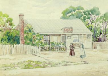
Painting, Winifred Miles, "First Post Office 1883" (Ringwood) - Water colour on paper by Winifred Miles (1884-1944), Undated, later than 1910
... (South side of Main Street (Maroondah Highway), approximately 300 meters west of Ringwood Railway Station). ...(South side of Main Street (Maroondah Highway), approximately 300 meters west of Ringwood Railway Station). ..."Alexander Colquhoun [Herald art critic 1914-1922 and feature writer for the Age 1926-1941] ... took private students in the first decade of the century, and one of these was Winifred Miles, who after her marriage in 1910 lived the remainder of her life in Ringwood. ... (She) began by doing charcoal studies of animals when she was in Balranald, but in later years moved to oils and then watercolours, travelling around Ringwood to find places to paint by means of a pony-driven governess-cart. She won prizes for paintings in the Royal Melbourne Shows." - Hugh Anderson - Ringwood, Place of Many Eagles [p.217].Painting with cardboard border in glass-fronted frame. Painted from an original black & white photograph, Catalogue Reg No. 1347 recorded as "Ringwood's first Post Office showing first Postmistress, Miss M. Thompson and her mother. 1890". (South side of Main Street (Maroondah Highway), approximately 300 meters west of Ringwood Railway Station). Writing on back of original photograph reads, "Grandma and Auntie Martha Thomson 1890". (Difference in painting date and photograph date indicates years as shown are approximate only). Sticker on back of frame - "Ringwood Framing Gallery, 233 Whitehorse Road Ringwood, Phone 8704930" -
Bendigo Historical Society Inc.
Newspaper - Bendigo Advertiser Collection: Small Town With Big Hearts Article on Marong, June 30 1993
... Marong is often overlooked by travelers who only see the main highway and intersection, missing the town's true character.Overall, the document conveys a deep appreciation for Marong's community spirit, natural beauty, and the importance of supporting local life. ...Marong is often overlooked by travelers who only see the main highway and intersection, missing the town's true character.Overall, the document conveys a deep appreciation for Marong's community spirit, natural beauty, and the importance of supporting local life. ...This document is a personal reflection on life in the small town of Marong. The reasons for living in Marong are described as deeply personal and sometimes hard to define, often tied to a sense of belonging and community.Tess Rule, a long-time resident, expresses genuine affection for Marong and its people, emphasizing the friendliness and strong social ties within the town. The document features a vivid description of Marong's picturesque landscape, including sunsets, Bullock Creek, gum trees, and local wildlife, capturing the town's rural charm. Tess values supporting local businesses and prefers to shop in Marong whenever possible, only traveling to nearby Bendigo for items unavailable locally. Marong is often overlooked by travelers who only see the main highway and intersection, missing the town's true character.Overall, the document conveys a deep appreciation for Marong's community spirit, natural beauty, and the importance of supporting local life. The creek is not permanent, but it is a significant natural feature, especially near the town's sporting grounds. The town is characterized by a strong sense of community and high levels of volunteer involvement, particularly in maintaining sporting grounds and organizing local events. Community members actively participate in fundraising and improvement projects, such as raising money for a new hall and restoring the historic shire hall. The Marong Hotel, built around 1917, is a central landmark and was once one of three hotels in town. The town has a history of gold mining and is located on the edge of the Golden Triangle.The old shire hall is being restored to its original 1908 condition, reflecting pride in local heritage. Marong supports a wide range of sports clubs (footy, tennis, swimming, shooting, riding, trotting, cricket, and more), which are central to community life. The hotel serves as a hub for both locals and travelers, with regulars including sports club members and truck drivers who stop for food. The population is around 580 and growing, as more people move from nearby urban areas. Ongoing development includes new housing and community facilities. The town is a notable stop for interstate truck drivers due to a sharp bend requiring them to slow down, leading to a gathering spot outside the hotel. The presence of palm trees throughout the town is a distinctive feature, with some believed to have spread from the hotel’s original palms.Small Towns With Big Hearts Maiden Gully. Series of photos and information about Marong. Pictures by Peter Hyett. Written by Wayne Gregson. This item contains the following documents newspaper articles and black and white photos: 8091.603a Part of Page 10, the Bendigo Advertiser Wednesday June 30 1993 8091.603b Part of Page 10, the Bendigo Advertiser Wednesday June 30 1993 8091.603c Church in Marong - Contact BHS for details 8091.603d Church in Marong - Contact BHS for details 8091.603e Holy Trinity Church in Marong - Contact BHS for details 8091.603f Former Shire of Marong Hall undergoing renovations - Contact BHS for details 8091.603g Calder Highway sign - Contact the BHS for details 8091.603h Picnic Table and Golf Course - Contact the BHS for details 8091.603i The Marong Hotel - Contact the BHS for details 8091.603j The Marong Hotel and Old Shire Hall from the railway crossing - Contact the BHS for details 8091.603k Rural City of Marong Chief Executive Officer Graeme Elvey inspects the $120,000 Shire of Marong Hall undergoing renovations - Contact BHS for details 8091.603l Rural City of Marong Chief Executive Officer Graeme Elvey inspects the $120,000 Shire of Marong Hall undergoing renovations - Contact BHS for details 8091.603m Truck entering Marong from the Calder Highway - Contact BHS for details 8091.603n The Post Mistress - Contact BHS for details 8091.603o Bar and patrons of the Marong Hotel - Contact BHS for detailsnewspaper, bendigo advertiser, marong -
 Ringwood and District Historical Society
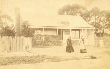
Photograph, Ringwood's first Post Office. 1890
... (South side of Main Street (Maroondah Highway), approximately 300 meters west of Ringwood Railway Station). ...(South side of Main Street (Maroondah Highway), approximately 300 meters west of Ringwood Railway Station). ...Two photographs (1 large black and white copy, 1 sepia original copy)Typed below large photograph: "Ringwood's first Post Office showing first Postmistress, Miss M. Thompson and her mother. 1890." (South side of Main Street (Maroondah Highway), approximately 300 meters west of Ringwood Railway Station). Writing on back of original photograph reads: "Grandma and Auntie Martha Thomson 1890." Stamps on back of photograph read, "Wall Bros. Photographers ... St. Kilda". Other stamp reads, "R.J.T. Futcher, Geelong, Victoria, Australia". -
 Ringwood and District Historical Society
Plan, Ringwood Station Estate, Subdivision, Ringwood, Victoria - circa 1925
... Other features marked include location of businesses along Main Street (Maroondah Highway), cool store, railway station, shop and police station on Bedford Road, church on Station Street, site of schoolmaster's residence and State School, and location of proposed public baths. ...Other features marked include location of businesses along Main Street (Maroondah Highway), cool store, railway station, shop and police station on Bedford Road, church on Station Street, site of schoolmaster's residence and State School, and location of proposed public baths. ...ID 5224 note: Further information relating to squares marked H, F, G, J, and K included in ID 5225 - Ringwood Shop and Dwelling Estate.Hand drawn plan of Ringwood Station Estate showing allotments for sale, with two typed pages attached showing land title information and sale prices.Drawn by Edyth Greenwood, phone 988 Central. Subdivision includes Station Street, Pitt Street, Bedford Road, Wantirna Road, James Street, William Street (later Kendall Street), Greenwood Avenue, Ellison Street, and Haig Street. Circles denote blocks for sale. Squares denote house properties for sale. Other features marked include location of businesses along Main Street (Maroondah Highway), cool store, railway station, shop and police station on Bedford Road, church on Station Street, site of schoolmaster's residence and State School, and location of proposed public baths. Ryner & Langford, Solicitors -
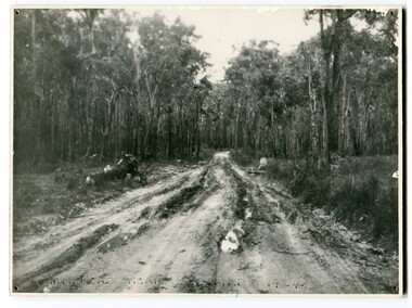 Orbost & District Historical Society
black and white photograph, 1924
... This photograph shows the main road near Bellbird, East Gippsland, in 1924. This road would have been the Princes Highway, a main thoroughfare through to New South Wales. ...Orbost & District Historical Society Ruskin Street Orbost gippsland This photograph shows the main road near Bellbird, East Gippsland, in 1924. This road would have been the Princes Highway, a main thoroughfare through to New South Wales. ...This photograph shows the main road near Bellbird, East Gippsland, in 1924. This road would have been the Princes Highway, a main thoroughfare through to New South Wales. Bellbird Creek is a small rural location between Orbost and Cann River. There was no township at Cabbage Tree at this time. The Cabbage Tree Creek township was established to support the booming timber industry of the mid 20th century. Five timber mills worked full time supporting the families that were drawn to the area's wealth of natural resources. Nestled on the banks of the Cabbage Tree Creek, the township was built by those mills to house their workers. Today although the timber mills have disappeared, some of the buildings still remain. Little now remains to remind of the saw-milling history apart from photographs and some relics - a boiler and a brick furnace. There was also a thriving agricultural community farming dairy, beef, seed beans and fresh peas and beans that were sent to the Victoria Market in Melbourne. Dairy farming still plays an essential role in the township. this is a pictorial record of the Princes Highway, the main road from East Gippsland to the New South Wales border.A large black / white photograph of a very wet and boggy bush road.on front - "Main Rd near Bellbird 1924"road princes-highway bellbird-creek-1924 -
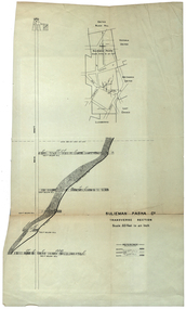 Federation University Historical Collection
Plan, Sulieman Pasha Co Plan Transverse Section
... The mine operated from two shafts; No. 1 near the corner of Humffray and Mair streets, and also near where the Welcome Nugget (2217 ounces) was found years earlier; and the controversial No. 2 shaft several blocks south bordering the northern side of the main highway through Ballarat. The company produced 62 666 ounces of gold, the twelfth highest quartz reef gold production for any mine on the Ballarat goldfield. ...The mine operated from two shafts; No. 1 near the corner of Humffray and Mair streets, and also near where the Welcome Nugget (2217 ounces) was found years earlier; and the controversial No. 2 shaft several blocks south bordering the northern side of the main highway through Ballarat. The company produced 62 666 ounces of gold, the twelfth highest quartz reef gold production for any mine on the Ballarat goldfield. ...The Sulieman Pasha is possibly named after the most important Sultan of the Ottoman Empire, Suleiman One, or Suleiman the Magnificent, when the Ottoman Empire was at its peak. Or potentially a number of Ottoman governors, statesmen and military commanders with the same name after, however the spelling is slightly different to the mine name. No Turkish connection was found relating to the formation of the company, and remains unconfirmed. The mine operated from two shafts; No. 1 near the corner of Humffray and Mair streets, and also near where the Welcome Nugget (2217 ounces) was found years earlier; and the controversial No. 2 shaft several blocks south bordering the northern side of the main highway through Ballarat. The company produced 62 666 ounces of gold, the twelfth highest quartz reef gold production for any mine on the Ballarat goldfield. Some crushing figure examples are January-June 1881: 3674 tonnes 1085 ounces; January-June 1885: 2949 tonnes 1281 ounces; July-December 1885: 4459 tonnes 1119 ounces; January-June 1887: 1869 tonnes 730 ounces; July-December 1892: 1450 tonnes 771 ounces; July-December 1896: 4365 tonnes 1372 ounces. Like many mines in the area, gold grades were low. John Watson was noted as mine manager in the 1880s, and John Williams 1890s. The company was re-organised twice increasing the number of shares from 4000 to 24 000, and increasing the capital available. The Sulieman Pasha Company was formed in 1878. David Fitzpatrick was given the honour of turning the first sod of both the No.1 and later No. 2 shafts. The first dividend was given to shareholders in July 1881. The company obtained a prospecting vote (government grant) to start, and was very proud to be the first Victorian gold mining company to pay the funds back to the government. The event was marked by a lavish banquet laid out for ministers and government officials by the company. Leases were purchased to the south in 1885 to the Llanberris Mine boundary, after poor results began accumulating from the small No. 1 shaft. To take advantage of this new land the company planned to sink a second shaft. Initially this was to take place on government land, but the uproar from nearby residents caused the company to purchase land along the Main Road (now Western Highway), and the old Yarrowee Hotel which had occupied the site since the alluvial digger days of the 1850's was demolished. The area had since those days become heavily occupied with a number of shops, houses, a post office, church and two schools in the immediate area. The thought of an underground mine next door drew considerable opposition. The company (before the days of public relations departments) wrote 'most people would have thought that progress as vital as mining would be supported by tradesmen whose business rely on the mining industry. It seems when it comes to mining they are bereft of their senses, and considering the low ebb of mining in Ballarat East, the action of our opponents are unaccountable. (Sarcastically) There are certain engineering difficulties in moving the quartz reefs to a new location, but if we could to appease our opponents we would'. The company also wanted to take over 4 acres of the St Paul's school oval for machinery, but accused the St Paul's Church of wanting extortionate amounts of money upfront, and on a yearly basis for the privilege. It stated the church could not be opposed to mining when several years earlier it had formed its own company to mine the land, only for shareholders to lose their money. In 1886, the company approached the Minister for Mines, and attended heated public meetings on the matter. The local residents, shop owners, and church submitted a 60 person petition to the local council and government authorities. They stated the shaft contravened the mining statutes, which stating no mining could take place within 150 yards of a public building or church. A speech by a resident stated 'mining always comes with glorious pictures of the great benefits which would accrue all parties concerned if their request is granted, but if property is destroyed or depreciated in value, no-one then comes forward and compensates them'. The No. 2 shaft was approved including taking over part of the school oval. In 1888, workers at the company's No. 2 shaft went on strike to try and bring their wages in line with other mines in the district (the No. 1 shaft was operated by tributers). William Madden (26) was killed from a fall of earth underground the same year, while a year later his father John Madden (70) was similarly killed in the Madame Berry Mine elsewhere in the district. In 1897 as the amount of gold being found fell away, it came to light part of the deal to purchase the Yarrowee Hotel site was a 5% royalty on gold found. Shareholders could not understand why they were paying a royalty to the former owners of the property. The mine closed in 1898 due to a lack of gold. In 1902 a boy (age unknown) called Charles Lee was killed from a fractured skull while working to dismantle the Sulieman Pasha plant. The fuss over the No. 2 shaft had a sequel. On the company winding up, the land was purchased by J.S. Trethowan who built a house next to the shaft. In 1907, the shaft caved-in creating a sinkhole immediately at the back of the house. A Mr Chamberlain heard a deep rumbling sound at 5am, and looked out the window to see his fowl house and thirteen chickens disappear down an expanding hole. He then went back to bed, and called the police later in the day. The shaft was 1050 feet deep, and the hole at the surface that developed was 20 feet by 17 feet across, and 20 feet depth. In 1930 it is reported a syndicate had been formed to clean out the old shaft, and re-open the mine. It is assumed this was the No. 1 shaft but no more was found. (https://www.mindat.org/loc-304239.html, accessed 07/08/2019) A transverse section plan of the Sulieman Pasha Mine.sulieman pasha company, plan, mining, united black hill mine, victoria united mine, victoria street, britannia united mine, last chance mine, llanberris mine, ottoman empire, john watson, john williams, david fitzpatrick -
 Ringwood and District Historical Society
Letter, Property for sale - Ringwood Shop and Dwelling Estate, Ringwood, Victoria - circa 1925
... Other features marked include location of businesses along Main Street (Maroondah Highway), cool store, railway station, shop and police station on Bedford Road, church on Station Street, site of schoolmaster's residence and State School, and location of proposed public baths...Other features marked include location of businesses along Main Street (Maroondah Highway), cool store, railway station, shop and police station on Bedford Road, church on Station Street, site of schoolmaster's residence and State School, and location of proposed public baths Typewritten letter from A.V. ...ID 5225 note: Further information relating to allotments marked on the hand-drawn plan are included in ID 5224 - Ringwood Station Estate.Typewritten letter from A.V. Greenwood with hand drawn plan of Ringwood Shop and Dwelling Estate, detailed description of property for sale, and top and side elevation views of house. (7 pages)(Transcript of first page - to unknown recipient) Phone 988 Central, 331 Canty Greenwood Pty. Ltd. 5 Flinders Street Melbourne. Dear Sir, 1. Attached please find drawings of my house at Ringwood. 2. It is for sale at £4,865 or to let at £5 per week to an approved tenant. 3. I sold it to Mr. De Garis and vacated it, but it is now back on my hands. 4. I leased another place instead of living in my own. I may be able to cancel same; in the meantime, however, I propose to sell or let my own. The painters are now going through the place; re-varnishing, re-oiling and re-polishing so that in about five days it will look "spick and span". 5. The house was specially built under my own supervision. 6. It is very suitable for a high class Guest House, Doctor's residence, Hospital or Convalescent Home. If you know of anyone whom it might suit, please communicate with them. DESCRIPTION 7. It stands on 305 feet of land facing Greenwood Avenue. It is cement, roughcast and hardwood, well oiled, and is now being redone so that the house is as good as new; red tile roof; verandahs three sides; two sleep-outs; five bedrooms; large dining room; very large music room with nooks, upstairs lounge, study; sewing room; built-in wardrobes and cupboards throughout; handsome kitchen with handsome pantry cupboard with drawers and glass front; one bath room; one shower room; wash house with patent copper and laundry. Every modern convenience, hot water system (through copper pipes with large copper cylinder) electric lights everywhere, outside and in, Yan Yean water laid on everwhere throughout house and gardens. Floors throughout are the very best, close set, stained and polished; dainty lead light windows etc. 8. There is a big garage, with tiled roof and two rooms with all conveniences for a married couple. Property is well drained with a system of its own. The house stands upon the top of a hill close to Railway Station, say 500 feet from the Footbridge. 9. The garden has expansive shrubs; sheds; fernery; tennis court. 10. A handsome piece of furniture goes with the house; a combination pantry and storeroom for groceries, milk, bread etc., consisting of drawers, glass and wire doors, as mentioned above. 11. It is within easy distance of Melbourne as it is only two minutes from Ringwood Station, which is a frequent electric train service bringing it within 39 minutes of the City. It is thought better by some to go further out into the country atmosphere and walk a short distance at the end than to go by train 20 minutes then walk 15 to 20 minutes. 12. The price quoted of £4,865 is made up as follows - 305 feet of land @ £5 ... £1,515 Garage and dwelling ... £300 House hot water system, American cupboard ... £2,600 Water, fencing, sheds & drain ... £250 For the lot ... £4,865 Should you require copies of the enclosed drawings I shall be pleased to supply same. 13. Mr. J.B. McAlpin is the local agent, Phone Ring. 7 (after hours Ring. 44) or you may phone me Central 988. 14. The house is south of the line, facing Greenwood Avenue and immediately at the back of Ringwood House, which is also my property. Yours sincerely, A.V. Greenwood (illegible) ..... (Transcript of second page) RINGWOOD SHOP AND DWELLING ESTATE See these letters on plan attached (H.) Ringwood House and Shops on 100 by 150 feet of land fronting Bedford Road 100 feet @ £10 per foot - £1,000 House and shops - £2,400 ... £3,400 Ringwood House consists of Boarding House, (Phone 101) and two shops, mainly brick; 9 inch walls. Will carry another story. Has music room, dining room, entrance halls, 10 bedrooms, large verandahs, all conveniences, hot and cold water, and stands on what will become a most valuable business corner. (F.)(G.) Mr. Greenwood's house, garage and sheds, stands on 307 feet of land fronting Greenwood Avenue. See detailed description attached ... £4,865 (J.) Cottage on Block 81 in William Street ... £750 (K.) Cottage in Pitt Street ... £650 (Total) £9,665 ..... (Description of third page - Subdivision Plan) Drawn by Edyth Greenwood, phone 988 Central. Subdivision includes Station Street, Pitt Street, Bedford Road, Wantirna Road, James Street, William Street (later Kendall Street), Greenwood Avenue, Ellison Street, and Haig Street. Circles denote blocks for sale. Squares denote house properties for sale. Other features marked include location of businesses along Main Street (Maroondah Highway), cool store, railway station, shop and police station on Bedford Road, church on Station Street, site of schoolmaster's residence and State School, and location of proposed public baths -
 Warrnambool and District Historical Society Inc.
Booklet, Autograph Book, Late 1930s
... Dartmoor is a small settlement on the Princes Highway between Heywood and the South Australian border. It was first settled in the late 1850s and the main industry is the processing of timber from the surrounding pine plantations. ...Dartmoor is a small settlement on the Princes Highway between Heywood and the South Australian border. It was first settled in the late 1850s and the main industry is the processing of timber from the surrounding pine plantations. ...According to the front page this autograph book belonged to Patricia Spencer of Spencer Street, Dartmoor. Dartmoor is a small settlement on the Princes Highway between Heywood and the South Australian border. It was first settled in the late 1850s and the main industry is the processing of timber from the surrounding pine plantations. Patricia Spencer attended Warrnambool High School in the late1930s and this album contains a number of entries from Warrnambool High School in 1938. It also has a page of eleven signatures of the Head Master, George Langley and other teachers from Warrnambool High School. There are also entries from people from Mortlake and Panmure and other entries with the person’s address not indicated. Autograph books such as this one were commonly owned by young people in the 19th and 20th centuries (up to about 1950) and were very popular with young girls.This album, although incomplete and tattered, is of interest because it is a good example of the social custom, more popular a couple of generations back than it is today, of young people owning and obtaining signatures and verses from their friends and acquaintances. It is also important because it contains signatures of Warrnambool High School teachers in 1938 and there are other entries of interest. This is a small autograph album that was originally bound with a cardboard cover with red leather backing but now has no front cover and only part of the back cover. The pages are all loose and the front section (buff-coloured) has a cardboard piece with felt padding. The pages are coloured in a variety of pastel tones and there are many handwritten entries of verses and signatures, with several from the ‘B’ Form, 1938, of ‘W.H.S. (Warrnambool High School). The album appears to have belonged to Patricia Spencer from Dartmoor. Some of the pages are torn and stained. At the back there are remnants of a sketch of an Asian scene and a letter to ‘Pat’ for her birthday. ‘Autographs’ ‘Patricia Spencer, Spencer Street, Dartmoor’ autograph albums, patricia spencer, warrnambool -
 Kiewa Valley Historical Society
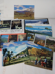
Photos, Postcards - Kiewa Valley
... Mt Beauty is a popular tourist resort. The main highway from Mt Beauty to the Bogong High Plains is most picturesque throughout the year. ...Mt Beauty township, at the head of the Kiewa Valley, is situated at the foot of Mt Bogong. The town was established by the State Electricity Commission of Victoria during the construction of the Kiewa Hydro Electric Scheme on the High Plains.Mt Beauty is a popular tourist resort. The main highway from Mt Beauty to the Bogong High Plains is most picturesque throughout the year. During the winter months, Falls Creek provides access to Falls Creek Ski Village for snow sports. Tawonga, 6.5 km north of Mt Beauty, is famed for its trout fishing and camping on the Kiewa River. Deciduous trees make a show of colour during Autumn. The postcards are of historical value showing photos taken at an earlier time.The postcards can be compared to the attractions of the time as they do not include cycling (mountain bikes and road bikes), snow boarding, gliding and paragliding. Advertising for tourism has also changed as attractions are now available on-line. 1. 9 Coloured Photos of Bogong (5) and Visitors Information Centre display (4) 2. Two fold out coloured sets of postcards "Mt Beauty and the Kiewa Scheme", "Mt. Beauty Victoria" 3. x10 Coloured postcards Mt Beauty, Kiewa Valley, Bogong 4. x6 Coloured postcards High Country and Bogong Villagepostcards kiewa valley -
 Orbost & District Historical Society
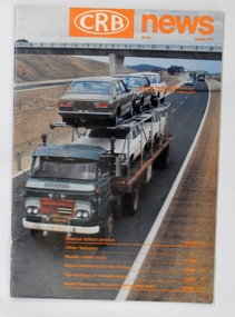
magazine, CRB News, August 1975
... main roads in Victoria between 1913 and 1983. It was succeeded by the Road Construction authority on 1 July 1983 and later merged with the Road Traffic Authority on July 1 1989 to form the Roads Corporation. James Cameron, an Orbost farming pioneer and Member of the Legislative Assembly, fathered the Country Roads Board. This item is a useful research source on the Princes Highway ...The Country Roads Board was the government authority for the construction and maintenance of main roads in Victoria between 1913 and 1983. It was succeeded by the Road Construction authority on 1 July 1983 and later merged with the Road Traffic Authority on July 1 1989 to form the Roads Corporation. James Cameron, an Orbost farming pioneer and Member of the Legislative Assembly, fathered the Country Roads Board.This item is a useful research source on the Princes Highway, Gippsland.A 19 pp magazine, titled CRB ( Country Roads Board) News. It is dated August 1976. On the front cover is a coloured photograph of a truck carrying cars. In the background is a road bridge. It contains an article on the Princes Highway, Gippsland.magazine journal-crb-news princes-highway -
 Upper Yarra Museum
Glass container, 1898 (exact); before 1898, product was trademarked in 1898
... Highway Yarra Junction yarra-valley-and-dandenong-ranges http://www.clag.com.au/about/about.htm http://en.wikipedia.org/wiki/Clag_(glue) Clag was first trademarked in 1898 by Joseph Angus, manufacturer, of 216 Nicholson Street, North Fitzroy, Melbourne. The National Archives of Australia holds the original trademark application - a digitised version is available online (see References). The exact composition of the original paste is unknown but is thought to have been starch-based. Australian schools commonly request that parents purchase Clag paste for their children as part of the stationery lists that are circulated before each school year. The main ...http://www.clag.com.au/about/about.htm http://en.wikipedia.org/wiki/Clag_(glue) Clag was first trademarked in 1898 by Joseph Angus, manufacturer, of 216 Nicholson Street, North Fitzroy, Melbourne. The National Archives of Australia holds the original trademark application - a digitised version is available online (see References). The exact composition of the original paste is unknown but is thought to have been starch-based. Australian schools commonly request that parents purchase Clag paste for their children as part of the stationery lists that are circulated before each school year. The main reason for this is Clag's reputation for safety and ease of use. The bottle includes a brush recessed into the lid that children find relatively easy to handle, and the packaging does not contain any small components that children might swallow. The main ingredient of Clag is wheat starch dissolved in a water base, meaning that children can safely swallow the glue without incident It feels cold to touch and when applied to paper, it sometimes alters the colour of what is on it and causes paper to warp, owing to the high water content of the glue. There is an Australian slang usage of the word "clagged" derived from the characteristic of Clag Paste and can be used in place of the words, "clogged", "congested", "restricted" or "stuck". Bottle used for clag. The bottle has the original marking made by Angus P/l who trademarked the glue in 1898.Angus & Co Pty Ltd, ISM 12school, bottle, glue, clag, trademark, wheat starch -
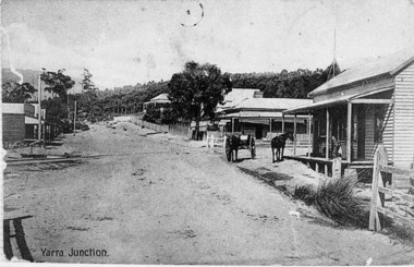 Upper Yarra Museum
Negative Photographic Reproduction, Main St Yarra Junction
... Upper Yarra Museum Old Railway Station 2415C Warburton Highway Yarra Junction yarra-valley-and-dandenong-ranges This intersection was a busy one with the tramway traffic having Steam Engines and their trucks crossing about 8 times a day, horsedrawn vehicles often had trouble crossing the tramway because it was quite uneven at times. yarra junction main street rail crossing 03037 PC Main Street Yarra Junction, at the corner of Little Yarra Rd, the Powelltown tramway crosses the road at this intersection Upper Yarra Shire 1888-1988 Centenary collection. ...This intersection was a busy one with the tramway traffic having Steam Engines and their trucks crossing about 8 times a day, horsedrawn vehicles often had trouble crossing the tramway because it was quite uneven at times.03037 PC Main Street Yarra Junction, at the corner of Little Yarra Rd, the Powelltown tramway crosses the road at this intersection Upper Yarra Shire 1888-1988 Centenary collection. Negative, Black & white. Scanned at 600 dpi. yarra junction main street rail crossing -
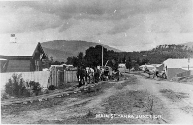 Upper Yarra Museum
Negative Photographic Reproduction, Main St Yarra Junction
... Upper Yarra Museum Old Railway Station 2415C Warburton Highway Yarra Junction yarra-valley-and-dandenong-ranges main st yarra junction station masters house gilderoy tramway 03039 PC Main street Yarra Junction. ...03039 PC Main street Yarra Junction. Team of horses pulling sawn timber on log bogies along the wooden Gilderoy tramline. Upper Yarra Shire 1888-1988 Centenary collection. Black & white Negative, scanned at 600 dpimain st yarra junction station masters house gilderoy tramway