Showing 124 items matching "map cases"
-
 Bendigo Military Museum
Map - MAP CASE & MAPS, Hec Robinson, C.1939-45
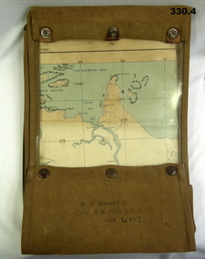
... MAP CASE & MAPS......Map Cases....1) Map case, canvas khaki. .2) Map of Darwin, NT. ...Scale 4 miles to 1 inch. .3) Map, folded, New Guinea made by Hec Robinson Sydney .4) Map Pine Creek N.T. Map MAP CASE & MAPS Hec Robinson ...John James Davies No VX35280 enlisted in the 2nd AIF on 1.8.40 age 31 years. At discharge on 30.11.45 he held the rank of WO 2nd class in 2/108th Aust Light Anti Aircraft detachment..1) Map case, canvas khaki. .2) Map of Darwin, NT. Scale 4 miles to 1 inch. .3) Map, folded, New Guinea made by Hec Robinson Sydney .4) Map Pine Creek N.T.zippered section marked "J. J. Davies VX35280 108 LAD”maps, wwii, world war two, second world war, map cases, darwin, northern territory, pine creek, papua new guinea, navigation, pouches -
 Running Rabbits Military Museum operated by the Upwey Belgrave RSL Sub Branch
Pack
... Map case, Australian, Pat.15....Running Rabbits Military Museum operated by the Upwey Belgrave RSL Sub Branch 1 Mast Gully Road Upwey melbourne Equipment WW1 Army Map case, Australian, Pat.15. Pack ...Map case, Australian, Pat.15.equipment, ww1, army -
 Wangaratta High School
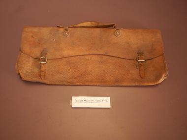
WHS Leather Map Case, Circa 1916
... WHS Leather Map Case...Orange-brown leather map case with metal buckles. ...Wangaratta High School 17-49 Edwards Street Wangaratta high-country Orange-brown leather map case with metal buckles. WHS Leather Map Case ...Orange-brown leather map case with metal buckles. -
 Lilydale RSL Sub Branch
map - WWII Australian map, C. G. Hartley & Co 1943, 1943
... WWII Australian Issue Map Case/ Plotting Board - with map...Lilydale RSL Sub Branch 52 Anderson Street Lilydale yarra-valley-and-the-dandenong-ranges WWII Australian Issue Map Case/ Plotting Board - with map map WWII Australian map C. ...WWII Australian Issue Map Case/ Plotting Board - with map -
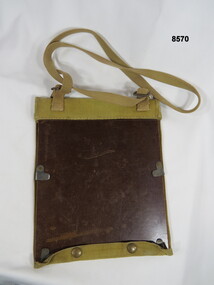
 Frankston RSL Sub Branch
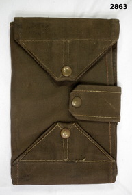
Map Case
... Map Case...Standard Australian Army webbing map case with shoulder strap. This map case is complete with a folded Australian Survey map of Puckapunyal, Victoria produced in 1988. ...Inscription BHG Ltd 1945 Map Case ...Standard Australian Army webbing map case with shoulder strap. This map case is complete with a folded Australian Survey map of Puckapunyal, Victoria produced in 1988. Inscription BHG Ltd 1945 -
 Running Rabbits Military Museum operated by the Upwey Belgrave RSL Sub Branch
Map Case
... Map Case...Map Case with carry strap containing computer print of various uniforms...Running Rabbits Military Museum operated by the Upwey Belgrave RSL Sub Branch 1 Mast Gully Road Upwey melbourne Equipment 1943 Army Map Case with carry strap containing computer print of various uniforms Map Case ...Map Case with carry strap containing computer print of various uniformsequipment, 1943, army -
 Stawell Historical Society Inc
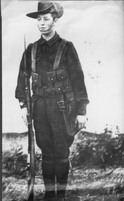
Photograph, Mr Sydney Davidson as a Soldier in WW1 in uniform with rifle, webbing, & map case 1914-1918 -- Studio Portrait
... Mr Sydney Davidson as a Soldier in WW1 in uniform with rifle, webbing, & map case 1914-1918 -- Studio Portrait...Portrait Sydney Davidson 1914-18 Soldier WW1 in uniform with rifle webbing and map case...Stawell Historical Society Inc 46 Longfield St Stawell grampians Portrait Sydney Davidson 1914-18 Soldier WW1 in uniform with rifle webbing and map case Stawell War Mr Sydney Davidson as a Soldier in WW1 in uniform with rifle, webbing, & map case 1914-1918 -- Studio Portrait Photograph ...Portrait Sydney Davidson 1914-18 Soldier WW1 in uniform with rifle webbing and map casestawell war -
 Creswick Campus Historical Collection - University of Melbourne
Equipment, Curvimeter
... For measuring distance of irregular line on maps. Cased in blue box with clear lid...For measuring distance of irregular line on maps. Cased in blue box with clear lid Equipment Curvimeter Equipment ...Steel tool with moving wheel attached to measurement dial. For measuring distance of irregular line on maps. Cased in blue box with clear lidEquipment -
 Bendigo Military Museum
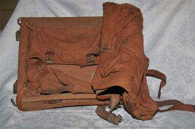
Equipment - CARRY PACK, TWO POUCH, Unknown
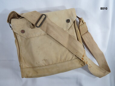
... ...Map case...This carry pack was possibly used as a map case, The over the shoulder strap is missing. ...This carry pack was possibly used as a map case, The over the shoulder strap is missing. ...The faded possible Regt number TX1823 there is no match found.Medium size khaki over the shoulder, carry pack with two rear compartments. This carry pack was possibly used as a map case, The over the shoulder strap is missing. There are three brass ventilators on the base of the pack.On the inside of the main flap, “TX1823” (open for interpretation). Very faded “B.M/ ??? TORAL”passchendaele barracks trust, equipment, bag, map case -
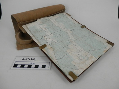
 Bendigo Military Museum
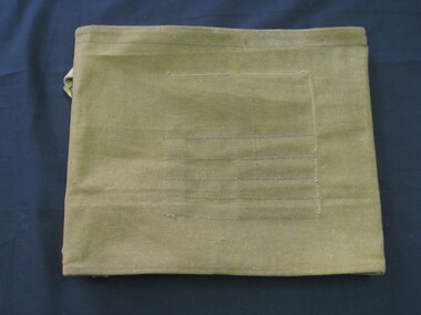
Equipment - MAP CASE, Army Issue, Post WW2 possibly
... MAP CASE...Map Case, khaki canvas outer, tri-fold with clear perspex sections for securing map inside. ...Small pocket on outside. Equipment MAP CASE Army Issue ...Map Case, khaki canvas outer, tri-fold with clear perspex sections for securing map inside. Fastens with two canvas flaps & brass press studs & a canvas strap. Small pocket on outside. military equipment, containers, map, passchendaele barracks trust -
 Montmorency–Eltham RSL Sub Branch
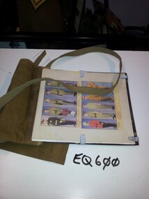
Equipment - Map Case No. 2, 1942
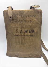
... Map Case No. 2...This 1942-dated Map Case was still in use post-1982 when it was used by a member of the 5/6 Royal Victoria Regiment. ...Two brass buckles are provided for a web shoulder sling. Equipment Map Case No. 2 C. G. Hartley & Co. ...This 1942-dated Map Case was still in use post-1982 when it was used by a member of the 5/6 Royal Victoria Regiment. This new Melbourne-based battalion was created on the 17 August 1982. Open-sided with a khaki canvas flap attached to a resin-impregnated board.. Hinged to the top edge is a celluloid cover. Four clips holds the cover (and any map) to the backing board. The flap is secured by a pair of Carr Australia press studs on the back. The underside of the flap has four loops for chinagraph pencils and a wider pocket and loop for a Protractor. Two brass buckles are provided for a web shoulder sling. C. G. Hartley & Co. 1942 ORMISTON 3200879 5/6 RVR -
 Flagstaff Hill Maritime Museum and Village
Document - Navigation Chart, British Admiralty, Otago Harbour, 1928
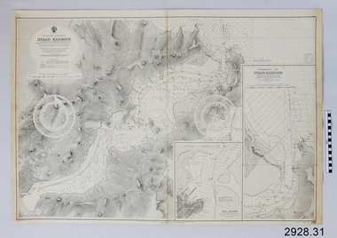
... The chart was originally stored in a wooden map case with over 60 other charts. ...The chart was originally stored in a wooden map case with over 60 other charts. Otago Harbour Document Navigation Chart British Admiralty ...Navigation charts are used by mariners around the world for navigating waterways. This chart was created for Otago Harbour in New Zealand. A ship, "Otago", was named after this harbour and was once commanded by the renowned maritime author Joseph Conrad. That ship now lies wrecked in Otago Bay, in the Derwent River, Tasmania. The Otago 1869-1931 The iron-hulled 3-masted barque Otago was built in Glasgow by Alexander Stephen & Sons Ltd, Kelvinhaugh, as a merchant ship and launched in 1869. The vessel changed hands several times in the late 19th century after being sold to an Australian firm in 1871. During one of its voyages, the captain died while the ship was in port at Bangkok. The renowned marine fiction author, Joseph Conrad (1857-1927), was on board and being a qualified captain, he took command and continued the journey to Sydney and Mauritius. It was the only ship he ever commanded. In 1903, the Melbourne shipping company Huddart, Parko & Co., purchased the Otago and converted it to serve as a coal hulk for use in Sydney. The Otago was later sent to Hobart, Tasmania, where it continued as a hulk until 1931. It was sold for scrap and eventually abandoned on the banks of the Derwent River at a place now known as Otago Bay, opposite Conrad Drive, Otago. The outline of the hull is still visible, and a nearby plaque tells the story. There are other vessels also named Otago, one of them in the same year. This navigation chart was published by the British Admiralty cartographer, to aid mariners to navigate the world's water bodies. Navigation charts are still used today, along with other navigational instruments.British Admiralty Navigation Chart - Otago Harbour, South Island, New Zealand. Chart shows insets with finer detail of important sections. The chart was originally stored in a wooden map case with over 60 other charts. Published in London, 1928, by the British Admiralty. Printed in Melbourne.warrnambool, shipwrecked-coast, flagstaff-hill, flagstaff-hill-maritime-museum, maritime-museum, shipwreck-coast, flagstaff-hill-maritime-village, shipwrecked-artefact, british admiralty navigation chart, navigation chart, british admiralty, otago harbour, south island, new zealand, otago bay, derwent river, tasmania, joseph conrad -
 Flagstaff Hill Maritime Museum and Village
Container - Chart Case, Late 19th to early 20th centuries
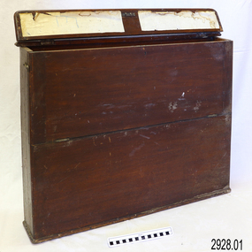
... ...map case...Chart case (or map case), wooden, has hinged opening at top. ...Chart case (or map case), wooden, has hinged opening at top. ...This case was donated along with the contents of over 60 navigational charts for locations all over the world. The narrow box is built to keep the charts in order and easily accessible on board a vessel. The chart case is a rare example of a container used on board a vessel for the storage and protection of navigational charts. It represents the type of equipment used by the navigator of a seafaring vessel. The charts within the case represent the places to which the vessel travelled.Chart case (or map case), wooden, has hinged opening at top. Front of case folds down and has a hook closure. It contained 65 British Admiralty navigational charts, which are listed and stored separately. (See separate items 2928.2 to 2928.66)There is a hand written name on the back of the case.flagstaff hill, warrnambool, shipwrecked coast, flagstaff hill maritime museum, maritime museum, shipwreck coast, flagstaff hill maritime village, great ocean road, map case, chart case, map box, chart box, british admiralty charts, navigational charts, hydrographer charts, navigation, ship equipment -
 Bendigo Military Museum
Map - AIR PHOTO MAP & HOLDER, 1962 - 1972
... ...Map Case...The map has a waterproof cover. 2. Map case, canvas khaki, it also has a Bakelite sheet backboard and a celluloid cover sheet. ... has a waterproof cover. 2. Map case, canvas khaki, it also has a Bakelite sheet backboard and a celluloid cover sheet. on the back board are 4 steel clips to hold the folded map. ...The Phuoc Tuy Border is about 58 kms E,S,E, from Ving Tau.1. Air photo of part of Phuoc Tuy Province, Sun. Overlaid on the air photo is - Principal height contours, Highway marked in red, names of villages and waterways and coastal depth soundings in fathoms. The map has a waterproof cover. 2. Map case, canvas khaki, it also has a Bakelite sheet backboard and a celluloid cover sheet. on the back board are 4 steel clips to hold the folded map. The case is held shut with brass press studs. The case has a khaki webbing strap affixed with brass fittings. 3. China graph pencil, yellow. Made by Staedtler and it is also embossed Commonwealth of Australia.1. The number “12” is written in numerous places. 2. On rear of case is some letters “O.C. HART .........? 1942” On the celluloid are some blue markings - looks like a house layout.vietnam war, map, map case -
 Ringwood RSL Sub-Branch
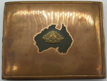
Card - Souvenir card holder
... Gold coloured metal case with map of Australia on outside...Ringwood RSL Sub-Branch 16 Station Street Ringwood melbourne Gold coloured metal case with map of Australia on outside Card Souvenir card holder ...Gold coloured metal case with map of Australia on outside -
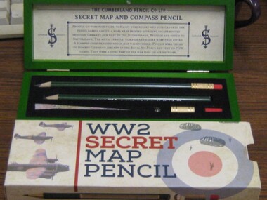 Running Rabbits Military Museum operated by the Upwey Belgrave RSL Sub Branch
Secret Map and Compass Pencils
... Two pencils in green wooden case, with map. Given to Lancaster airmen WW2....Running Rabbits Military Museum operated by the Upwey Belgrave RSL Sub Branch 1 Mast Gully Road Upwey melbourne Equipment WW2 RAF Two pencils in green wooden case, with map. Given to Lancaster airmen WW2. Secret Map and Compass Pencils ...Two pencils in green wooden case, with map. Given to Lancaster airmen WW2.equipment, ww2, raf -
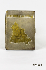 Whitehorse Historical Society Inc.
Container - Cigarette Case, 1940's
... Metal cigarette case. Map on front shows the U.S. Occupied Zone of Germany in the post war years....Zone of Germany Metal cigarette case. Map on front shows the U.S. Occupied Zone of Germany in the post war years. ...Metal cigarette case. Map on front shows the U.S. Occupied Zone of Germany in the post war years.|Perhaps issued or sold to the U.S. Forces. There is a clip inside to hold cigarettes.U.S. Zone of Germanypersonal effects, smoking accessories -
 Bendigo Military Museum
Equipment - FIELD CASE, MAP, Unknown
... FIELD CASE, MAP...Khaki over the shoulder field case for maps or documents. The backing base is covered in cotton khaki material with bottom press stud closure buttons. ...Bendigo Military Museum 37 - 39 Pall Mall Bendigo goldfields Passchendaele Barracks Trust Field case Maps and documents Khaki over the shoulder field case for maps or documents. ...Khaki over the shoulder field case for maps or documents. The backing base is covered in cotton khaki material with bottom press stud closure buttons. Maps or documents are held in place by adjustable slide over clips. On the inside of the cover there are six sewn in narrow pockets for pens, pencils and relevant recording items.passchendaele barracks trust, field case, maps and documents -
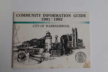 Warrnambool and District Historical Society Inc.
Booklet - Booklet Collection: City of Warrnambool Tourist Guides, Collett, Bain and Gaspar, Warrnambool
... map of the city of Warrnambool. [.15] A 48 page colour booklet on glossy paper. The front cover has white writing over colour photographs of two people at a lookout, Flagstaff Hill, three southern right whales and a child at the Lake Pertobe playground. The lower edge has blue upper case...map of the city of Warrnambool. [.15] A 48 page colour booklet on glossy paper. The front cover has white writing over colour photographs of two people at a lookout, Flagstaff Hill, three southern right whales and a child at the Lake Pertobe playground. The lower edge has blue upper case ...This is a collection of sixteen tourist guides dating from the mid 1970's to 2013. These contain listings of businesses, accommodation, eateries and events in Warrnambool and district. They also include maps of Warrnambool and surrounds, advertising and photographs of various attractions. While mainly covering Warrnambool a small number of the guides cover the South West Region. These directories have mainly been published by the Warrnambool City Council and are a selection of the types of information provided to visitors at the Tourist information centre during this time period.These tourist guides give snapshots of the City of Warrnambool for the years covered and will be useful for research.[.1] An 8 page paper booklet with black printing and a black & white photo of the pond at the Botanical Gardens on the front cover. [.2] two photocopied A4 black and white pages from the book "On the Trail" K Winser 1956 (Main Roads of Australia) [.3] A trifold colour brochure with a stylised map of the coast on the yellow and blue front cover. The inside has stylised colour drawings on Warrnambool attractions. The rear cover has coloured photographs of bush, Liebig Street and Fletcher Jones gardens [.4] A trifold black and white brochure with a black line drawing of a whale on the front cover. [.5] A trifold white card with mauve printing. The front cover has a line drawing of the former Timor Street post office and a map of businesses and landmarks in Timor Street. The reverse side contains a brief history of Warrnambool. [.6] A 98 page stapled booklet with a foreword by Vanda Savill. There are 4 pages of coloured photographs. The remainder are black and white photographs. The front cover is purple with white writing in the lower third. There is an outline of the coast and five colour photographs of district attractions. The inside middle page has a map of the Western wonderland region. The content covers towns in this area. Content relating to Warrnambool is in the last six pages. [.7] Twelve loose photocopied black and white pages. The front cover has the Warrnambool Premier Town 1988-1991 logo and a photo of a Southern Right Whale and calf. The bottom right hand corner has a Standard Warrnambool logo. [.8] 44 page booklet printed with blue ink. The staples have been removed. The glossy front cover has blue printing with a coloured photo of Flagstaff Hill Maritime Village pond. The centre pages has a fold out map of the City of Warrnambool. The rear cover has photos of The Twelve Apostles and Hopkins Falls. [.9] 4 loose photocopied pages with Warrnambool Library and Corangamite Regional Library Service Warrnambool City Library black ink stamps. The front page line drawing illustrations of Warrnambool attractions [.10] A single sheet of glossy white paper folded in half to make four pages. The front page has a Warrnambool premier town logo 1979-1982 and blue printing and a visitor survey. [.11] A conference pack of light card folded to make a pocket containing three brochures, a shipwreck coast tourist directory and a Australian Heritage Parks Association conference program dated 24 to 27 May 1992. The front cover of the pack has green writing over a stylised upward arrow. There is a City of Warrnambool logo in the top right hand corner and two film strips diagonally across the cover containing photographs of Warrnambool. The rear cover has a coloured Warrnambool Premier Town logo. [.12] A 63 page stapled booklet with coloured photographs of Warrnambool. The front cover has black writing on white background. There is a coloured photograph of Flagstaff Hill in the middle of the cover and a Warrnambool City and Visit Victoria logos on the lower edge. The middle pages has a coloured of the city of Warrnambool with an inset map of Allansford. [.13] A single large sheet of white paper folded in ten to make a brochure. The front cover has black printing. The rear cover has a purple ink stamp for the City of Warrnambool Tourist Information Centre. When folded out the reverse side has a green, grey and white map of the South West Region of Victoria. [.14] A 48 page colour booklet on glossy paper. The front cover has white writing on a blue background and includes photographs of the Twelve Apostles, the Promenade walk, Flagstaff Hill and a southern right whale's tail. The rear cover has photographs of The Twelve apostles, a passenger train from Melbourne passing the Lake Pertobe playground, and a rural scene. There is white writing and a white Warrnambool City logo on a blue background. The centre pages have a stylised green and blue map of the city of Warrnambool. [.15] A 48 page colour booklet on glossy paper. The front cover has white writing over colour photographs of two people at a lookout, Flagstaff Hill, three southern right whales and a child at the Lake Pertobe playground. The lower edge has blue upper case writing on a white background. The rear cover has a colour photograph of the Twelve Apostles. The lower white border on the rear covers has a a blue and green City of Warrnambool logo and blue writing. The centre pages have a stylised green and blue map of the city of Warrnambool. [.16] A 64 page colour booklet on glossy paper. The front cover has black writing on a black background and there is a photograph of a southern right whale's tail. The lower edge has the Warrnambool City and Visit Victoria Logos. The centre pages have maps of Warrnambool and surrounds. [.1] This week in Warrnambool Vol 2 No. 5 Thurs 1st Feb. For the time of your life [.2] Warrnambool Way [.3] Warrnambool The Holiday Host on the South West Coast with compliments City of Warrnambool and Warrnambool Chamber of Commerce [.4] MMI Insurance presents Whales Giants of the Deep Whale Watcher's Logbook Warrnambool [.5] Warrnambool History began in Timor Street [.6] Western Wonderland Tourist Association [.7] A Premier Arrow Tour of Warrnambool Victoria's Premier Town Australia's Southern Right Whale Nursery [.8] Warrnambool The Heart of Victoria's Great Southwest Visitor's Handbook [.9] What to see in Warrnambool Victoria's Premier City 1979-1982 [.10] Win a Free Holiday & $200 Cash in Victoria's Premier Town [.11] Advancing Warrnambool together! [.12] Great Ocean Road Warrnambool Official Visitor Guide [.13] Tourist guide to the South West Region Victoria All it needs is you [.14] Warrnambool visitor guide 2005 the great ocean road experience attractions accommodation entertainment dining [.15] Warrnambool Visitor Guide 2006 the great ocean road experience Attractions Accommodation Entertainment Dining [.16] Official Visitors' Guide Warrnambool Victoria Australia Discover the Great Ocean Road warrnambool, warrnambool tourist guides -
 Warrnambool and District Historical Society Inc.
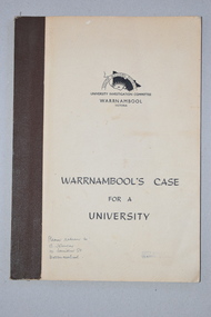
Booklet, Warrnambool's Case for a university, 1961
... It has printed information, black and white photographs, a fold-out map, graphs and tables. Warrnambool's Case for a university Booklet ...The information in this booklet was prepared by a University Investigation Committee formed in Warrnambool in 1961 to present the case for the establishment of a university in the Warrnambool area. The chairman of this committee was the Mayor of Warrnambool, Cr P. O’Sullivan and the secretary was W. L. George of Warrnambool. This submission was unsuccessful at the time but campaigning for a university continued. In 1961 Warrnambool Technical School in Timor Street was offering both secondary and tertiary courses in the technical and trades areas and in 1969 the tertiary section of this Technical School became the Warrnambool Institute of Advanced Education. The tertiary section was relocated in 1984 to Sherwood Park, a 94 hectare site on the Princes Highway five kilometres from Warrnambool’s C.B.D. In 1990 Deakin University established a regional campus at Sherwood Park after a merger with the Warrnambool Institute of Advanced Education. This booklet has some historical significance as it contains the information collated on the campaign in Warrnambool and the Western District for a university to be established in the Warrnambool area.This is a soft cover booklet of 48 pages. It has a beige-coloured cover with black printing. The booklet has been bound with brown tape. It has printed information, black and white photographs, a fold-out map, graphs and tables.deakin university, history of warrnambool -
 Warrnambool and District Historical Society Inc.
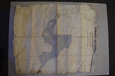
Map - Maps, Soldiers Settlement WW2, Circa 1950
... Some have details of the people allocated the land and some smaller maps have the printed details of the applicants requirements.Text is black on white paper which in some cases is quite aged. ...Some have details of the people allocated the land and some smaller maps have the printed details of the applicants requirements.Text is black on white paper which in some cases is quite aged. ...The soldiers' settlement scheme operated after the first and second world wars in an effort to more closely settle the land and also give opportunities to returned soldiers. Crown land and other larger estates were acquired for the purpose. Most of these maps relate to the area north of Warrnambool where many of the subdivisions were parts of larger estates.These maps pertaining to the Soldiers' Settlement program, relate to an interesting part of Australian and local history. As such they have historic and social interest and significance.A collection of 25 paper maps which relate to to the soldiers settlement post World War 2. Some have details of the people allocated the land and some smaller maps have the printed details of the applicants requirements.Text is black on white paper which in some cases is quite aged. The maps are as follows: .1 Narrapumelap Estate ( Ripon & Hampden) .2 Narrapumelap Estate Part 2 (Villers & Ripon) .3 Narrapumelap Estate Part 3 ( Villiers & Ripon) .4 Burrumbeet Estate ( Ripon) .5 ' Berrambool' Estate 9 Hampden & Villiers) .6 ' Hopkins Hill' Estate Villiers 4011 acres .7 Caramut North No 2 Estate ( Villiers ) .8 ' Morpor' Estate ( Villiers) 4172 acres .9 ' Morgiana' Estate ( Normandy) 3453 acres .10 ' Chatsworth House' ( Villiers) 9341 Acres .11 ' East Elwood' Estate Villiers 2407 acres .12 Grey's Estate ( Mornington) 1151acres .13 ' Rowes Estate' ( Buln Buln Gippsland 733 acres .14 'Tarrone' Estate No 2 Part map .15 'Chaldon Meade' Estate (Bourke) Bulla 517 acres .16 ' Terranallum South' Estate Hampden 3757 acres .17 ' Brung Brungle' Estate Dundas 695 .18 ' Armidale ' Estate ( Dundas)2108 acres .19 ' Moyne Falls' Estate ( Villiers) 627 acres .20' Yulong' Estate 9 Lowan 6321 acres .21 Murray Valley Irrigation District 9 Moira)113 acres .22 Murray Valley Irrigation District 103 acres .23 ' Mount Fyans' Estate ( Hampden) .24 ' Barwidgee ' Estate ( Villiers) 4277 acres .25 'Pine Hills' Estate 2nd portion ( Lowan) 6190 acres narrapumelap, berrambool, hopkins hill, caramut north, morpor, chatsworth house, east elwood, terrinallum, moyne falls, tarrone, caramut soldiers settlers, burrumbeet, morgiana, grey's estate mornington, chaldon meade, brung brungle -
 Warrnambool and District Historical Society Inc.
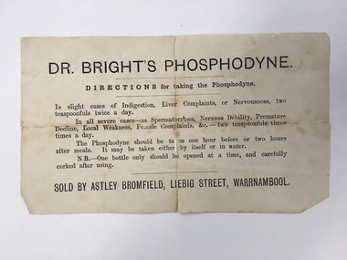
Document, Docket Dr Bright's Phosphodyne, Mid 19th century
... It was widely sold by chemists throughout Australia in the 19th century and in this case was supplied by the Warrnambool chemist, James Astley Bromfield. He was a significant person in Warrnambool’s history as he produced the 1856 map of the Warrnambool district showing all the original landholders, a seminal resource for historians today. ...It was widely sold by chemists throughout Australia in the 19th century and in this case was supplied by the Warrnambool chemist, James Astley Bromfield. He was a significant person in Warrnambool’s history as he produced the 1856 map of the Warrnambool district showing all the original landholders, a seminal resource for historians today. ...This label accompanied a bottle of Dr Bright’s Phosphodyne. It was a form of medicine also known as ozonic oxygen which was developed and patented in 1869 by Dr Charles Bright, a 19th century Resident Surgeon at St Mary’s Hospital London, The medicine claimed to ease ‘indigestion, liver complaints, nervous debility, female complaints, premature decline, local weakness and spermatorrhea’. It was widely sold by chemists throughout Australia in the 19th century and in this case was supplied by the Warrnambool chemist, James Astley Bromfield. He was a significant person in Warrnambool’s history as he produced the 1856 map of the Warrnambool district showing all the original landholders, a seminal resource for historians today. Bromfield had a chemist shop in Warrnambool from 1854 to the late 1880s, initially in Timor Street and then in Liebig Street (number 80 and later number 78). Bromfield was very active in local community affairs. This label is of considerable interest as it shows the use in the 19th century of medicine that today would be labelled ‘quack’. It is of particular interest as it was supplied by James Astley Bromfield’s chemist shop and he is an important early identity in Warrnambool, involved in many activities in the town. He was a Justice of the Peace, a Trustee of the Savings Bank, Chairman of the Western Steam Navigation Company, a Director of the Gasworks and on the committees of the Harbour Committee, the Fire Brigade and the Anglers Protection Society. He was a Warrnambool Councillor (1858-60; 1865-1870) and a Shire Councillor (1875-1883). This is a sheet of paper that accompanied a bottle of Dr Brights’ Phosphodyne medicine. It is buff-coloured with black printed material. It is in two pieces and dog-eared at the edges.warrnambool, dr bright's phosphodyne, james bromfield chemist, warrnambool chemists -
 Bendigo Military Museum
Map - RASvy " Map Makers Exhibition 2025 "- Map display, RAN Hydrographic Office, 1972 - 1992
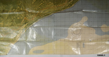
... maps together. The charts are based on a single point of tangency (in this case Darwin) and shows radius (distance) in nautical miles to and from that point. ...maps together. The charts are based on a single point of tangency (in this case Darwin) and shows radius (distance) in nautical miles to and from that point. ...All of these Charts / Maps were used for the RSL Museum display " The Mapmakers " ( of RASvy. ) 10 Jun - 10 Aug 2025. .1 Catalogue of Tactical Pilotage Charts, 1:500 000 Scale. Digital Data Base available as at 30Jun 92. This catalogue page shows the extent of the Australian area of responsibility for aeronautical charting. .2 RAAF PLOTTING CHART. NP 22-2 (Navigational Plotting) Tasmania. MERCATOR PROJECTION. This series of charts were used for the training of RAAF Navigators. These charts were produced and printed at the Army Survey Regiment, Bendigo. .3 RAAF PLOTTING CHART AUSTRALIA - SOUTHEAST. NP 27 is Based on LAMBERT CONFORMAL CONIC PROJECTION. This series of charts was used by RAAF Navigators for the planning of RAAF flights. These charts were produced and printed at the Army Survey Regiment, Bendigo. .4 RAAF LONG RANGE PLOTTING CHART. NP 43-4 AUSTRALIA WESTERN. MERCATOR PROJECTION. This series of maps were used for the planning of RAAF flights. Of Particular note these charts were used to plot "Rhumb Lines or loxodromes" where a course crosses all Meridians (Lines of latitude and longitude) at the same angle. On Mercator projection charts Rhumb lines are conveniently shown as straight lines and are also lines of constant compass bearing. Rhumb lines are usually longer than the shortest distance between two points. The shortest distance between two points on the earth's surface is called a "Great Circle Route" which is a route on a circular path on the surface of the earth where the centre of that circle is also the centre of the earth. Great Circle Routes on a Mercator Projection are however curves and harder to plot. These charts were produced and printed at the Army Survey Regiment, Bendigo. .5 RAAF LONG RANGE PLOTTING CHART. NP 43-7 SOLOMON ISLANDS. MERCATOR PROJECTION. Used for the planning of RAAF flights. .6 RAAF AIR STAFF PLANNING CHART NS 137-1 DARWIN NORTH WEST. AZIMUTHAL EQUIDISTANT PROJECTION. This series of charts were used for planning by the staff. The whole chart was produced by joining the four quadrant maps together. The charts are based on a single point of tangency (in this case Darwin) and shows radius (distance) in nautical miles to and from that point. A series of charts were produced centred on each of the major airfields in Northern Australia. These charts were produced and printed at the Army Survey Regiment, Bendigo. .7 RAAF AIR STAFF PLANNING CHART NS 137-2 DARWIN NORTH EAST. AZIMUTHAL EQUIDISTANT PROJECTION. Used for the planning by the staff. The charts are based on a point of tangency and show radius in nautical miles. .8 RAAF AIR STAFF PLANNING CHART NS 137-4 DARWIN SOUTH WEST. AZIMUTHAL EQUIDISTANT PROJECTION. Used for the planning by the staff. The charts are based on a point of tangency and show radius in nautical miles. .9 RAAF AIR STAFF PLANNING CHART NS 137-3 DARWIN SOUTH EAST. AZIMUTHAL EQUIDISTANT PROJECTION. Used for the planning by the staff. The charts are based on a point of tangency and show radius in nautical miles. .10 TACTICAL PILOTAGE CHART. TPC R-13B. LAMBERT CONFORMAL PROJECTION. Used by pilots for flight planning and could be used in flight if necessary for visual navigation using major ground features shown on the chart. These charts also contained aeronautical information such as airfields, radio navigation beacons and obstructions. Contours and height information was shown in feet to be compatible with aircraft altimeters. Each graticule square also contained a Maximum Safe Elevation Figure (MEF) also in feet. Coverage of this series over Australia's area of interest were produced and printed at the Army Survey Regiment, Bendigo. .11 HYDROGRAPHIC CHART. AUS 158. PORT PHILLIP SOUTH and WEST CHANNELS. PROJECTION TRANSVERSE MERCATOR. Used by all people needing to navigate a vessel. Hydrographic charts were printed at the Army Survey Regiment, Bendigo. .12 HYDROGRAPHIC CHART. AUS 157. GEELONG HARBOUR and APPROACHES. PROJECTION TRANSVERSE MERCATOR. Used by all people needing to navigate a vessel. .13 EN ROUTE CHART. AUSTRALIA ERC HIGH. H1 and H2. LAMBERT CONFORMAL CONIC PROJECTION. This series of charts were regularly produced by the RAAF Aeronautical Information Service (AIS) and contained current aeronautical information for pilots. These charts were printed at the Army Survey Regiment, Bendigo..1 Tactical Pilotage Chart Series Catalogue. Current as at 30 Jun 92. .2 Extract of Navigational Plotting Chart " NP22-2 Tasmania " .3 Extract of Navigational Plotting Chart " NP 27 RAAF PLOTTING CHART AUSTRALIA - SOUTHEAST " .4 Extract of Navigational Plotting Chart " RAAF LONG RANGE PLOTTING CHART NP43-4 AUSTRALIA WESTERN " .5 Extract of Navigational Plotting Chart " RAAF LONG RANGE PLOTTING CHART NP43-7 SOLOMON ISLANDS " .6 Extract of Navigational Series " RAAF AIR STAFF PLANNING CHART NS 137-2 DARWIN NORTH WEST " .7 Extract of Navigational Series " RAAF AIR STAFF PLANNING CHART NS 137-1 DARWIN NORTH EAST " .8 Extract of Navigational Series " RAAF AIR STAFF PLANNING CHART NS 137-4 DARWIN SOUTH WEST " .9 Extract of Navigational Series " RAAF AIR STAFF PLANNING CHART NS 137-3 DARWIN SOUTH EAST " .10 Extract of Tactical Pilotage Chart " TPC R-13B " .11 Extract of Hydrographic Chart " PORT PHILLIP SOUTH and WEST CHANNELS " .12 Extract of Hydrographic Chart " GEELONG HARBOUR and APPROACHES " .13 Extract of En Route Chart " AUSTRALIA ERC HIGH " " H1 and H2 " royal australian survey corps, rasvy, fortuna, detachment - army survey regiment, army svy regt, asr -
 Bendigo Military Museum
Equipment - MAP CASE, Unknown
... MAP CASE......Map Case...The bag is fitted with an over the shoulder carry strap. Equipment MAP CASE ...Khaki carry bag carried over the shoulder, possibly used as a mapping carry case or survey bag. The top flap is secured by press stud closures, the bottom of the bag has small brass ventilators. The bag is fitted with an over the shoulder carry strap.passchendaele barracks trust, equipment, bag, map case -
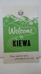 Kiewa Valley Historical Society
Leaflet - Kiewa, Welcome to Kiewa
... The SECV controlled the area so in case of accident, the SECV was the body to contact not eg. the police. state electricity commission of victoria; kiewa hydro electric scheme; gatehouse; safety rules; kiewa Small white and green leaflet made from one sheet of glossy paper and folded in half. Front cover has the title in the middle, the SECV emblem at the centre top and across the bottom is a message to read the inside pages which are safety messages for driving and bush fires. The back cover has a RACV road map ...The State Electricity Commission of Victoria constructed the Kiewa Hydro Electric Scheme from 1938 to 1961. The Scheme included three power stations, dams, tunnels and was becoming a popular tourist destination with Falls Creek Ski field within its boundaries.This leaflet was published by the SECV to ensure all visitors to the Kiewa Hydro Electric Scheme were made aware of safety measures with regard to their driving and to bush fires. These were necessary as the area was unique with driving on mountainous roads, changeable and extreme weather and the threat of bush fires. The gatehouse existed during construction, when the SECV was in charge, as a restriction to entry to the Scheme for SECV workers and those with permission to enter. The SECV controlled the area so in case of accident, the SECV was the body to contact not eg. the police.Small white and green leaflet made from one sheet of glossy paper and folded in half. Front cover has the title in the middle, the SECV emblem at the centre top and across the bottom is a message to read the inside pages which are safety messages for driving and bush fires. The back cover has a RACV road map of Kiewa and its 'works' including the Gatehouse which was the entrance to the scheme.The map also has an insert of the main roads & nearby cities. state electricity commission of victoria; kiewa hydro electric scheme; gatehouse; safety rules; kiewa -
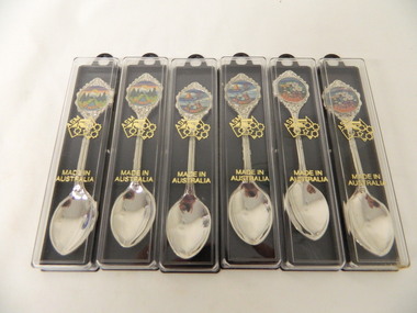 Kiewa Valley Historical Society
Spoons - Souvenir, Mt Beauty x6
... Map of Auistralia with ASM along the W.A. side / Made in / Australia Spoon: top of handle - Mt Beauty. back of handle - embossed kangaroo. back of stem - 'Swann and Hudson Made in Australia 6 spoons - 2 of each with a different picture. Silver spoon in a plastic case ...Souvenirs are sold to tourists as a moment of their visit to Mt BeautyMt Beauty is a tourist town6 spoons - 2 of each with a different picture. Silver spoon in a plastic case. The case has a black side with a ring at the top and 2 small pieces that jut out from inside to hold the spoon. The clear front cover fits on and has gold embossing. The stem of the spoon is embossed with lines on the front. At the end there is a circular coloured picture with 'Mt Beauty' below surrounded by embossed decoration.Cover: Map of Auistralia with ASM along the W.A. side / Made in / Australia Spoon: top of handle - Mt Beauty. back of handle - embossed kangaroo. back of stem - 'Swann and Hudson Made in Australiamt beauty. souvenir. silver spoon. tourism. swann and hudson -
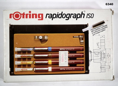 Bendigo Military Museum
Equipment - Rotring Rapidograph Iso Pen set, Circa 1980
... map overlay production. These pens produced lines of consistent line widths for cartographic ink work and these replaced the earlier "Crow Quill" ink nib pens. These pens were donated by 310762 WO1 PJ Presser (dec) who served in the Royal Australian Survey Corps from 11 Feb 1970 - 12 Feb 1990. Royal Australian Survey Corps RASvy Fortuna Army Survey Regiment Army Svy Regt ASR Rotring box Rapidograph Iso pen set with four pens in a plastic case ...Used extensively within the Royal Australian Survey Corps for the compilation of maps and for map overlay production. These pens produced lines of consistent line widths for cartographic ink work and these replaced the earlier "Crow Quill" ink nib pens. These pens were donated by 310762 WO1 PJ Presser (dec) who served in the Royal Australian Survey Corps from 11 Feb 1970 - 12 Feb 1990.Rotring box Rapidograph Iso pen set with four pens in a plastic case and two compass adaptors. Pen sizes: 0.25mm, 0.35mm, 0.50mm, 0.70mm, with instructionsroyal australian survey corps, rasvy, fortuna, army survey regiment, army svy regt, asr -
 Bendigo Military Museum
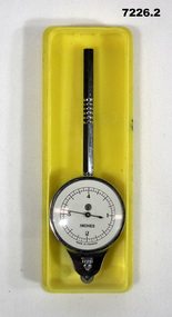
Equipment - MAP MEASURER/OPISMETER, DEPOSE
... MAP MEASURER, H(logo)B, MADE IN FRANCE'. .1) Circular chromed metal instrument with handle. Calibrated dial with black markings and hand on a white background. Reverse face has unit conversion details in black text on white background. Each face is covered with a convex glass lens. On the opposite end to the handle is a small wheel with milled edge. As it turns, the hand on the front dial turns to measure distance. .2) Rigid plastic rectangular storage case ...Vintage opisometer used for measuring distances on maps. Part of the Kevin John Herdman, No. 397661, Collection. See Catalogue No. 5942P for details of his service record..1) Circular chromed metal instrument with handle. Calibrated dial with black markings and hand on a white background. Reverse face has unit conversion details in black text on white background. Each face is covered with a convex glass lens. On the opposite end to the handle is a small wheel with milled edge. As it turns, the hand on the front dial turns to measure distance. .2) Rigid plastic rectangular storage case in two parts. Base is yellow, top is clear..1) Printed on front dial: 'INCHES, MADE IN FRANCE'. Printed on back dial: 'Unit conversion details'. Stamped on metal near wheel: 'DEPOSE, H(logo)B'. .2) Stamped on clear cover: 'CURVIMETRE, MAP MEASURER, H(logo)B, MADE IN FRANCE'.map, map measure, equipment, opisometer, kevin john herdman -
 Bendigo Military Museum
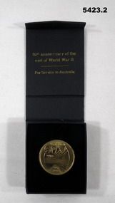
Memorabilia - MEDALLION, 60th ANNIVERSARY, C.2005
... .1) Case, black folding lid with magnetic close, black felt inset for the medallion, gold writing on lid top. .2) Medallion round gold colour, face has “60 Years”, map depiction of Australia, wording “World War 11 1945 - 2005, rear has Coat of Arms with “World War 11 Service to Australia”...On box top in gold, “Australian Government”, “Department of Veterans Affairs” .1) Case, black folding lid with magnetic close, black felt inset for the medallion, gold writing on lid top. .2) Medallion round gold colour, face has “60 Years”, map depiction of Australia, wording “World War 11 1945 - 2005, rear has Coat of Arms with “World War 11 Service to Australia” Memorabilia MEDALLION, 60th ANNIVERSARY ...Item in collection re John Eric Wiles VX16067, refer Cat No 5410P for his service details..1) Case, black folding lid with magnetic close, black felt inset for the medallion, gold writing on lid top. .2) Medallion round gold colour, face has “60 Years”, map depiction of Australia, wording “World War 11 1945 - 2005, rear has Coat of Arms with “World War 11 Service to Australia”Bottom of case stuck on label typed, “J. E. Wiles 2/7 INF BN Vx16067”. On box top in gold, “Australian Government”, “Department of Veterans Affairs”medallions, 60th anniversary, 1945 - 2005, wiles -
 Bendigo Military Museum
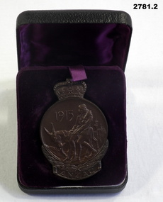
Memorabilia - MEDALLION WW1, Australian Government, c.1965
... The reverse shows a map of Australia & New Zealand & the Southern Cross. On the bottom banner is engraved the name "T H POCOCK" The metal case is covered in black vinyl. ...The reverse shows a map of Australia & New Zealand & the Southern Cross. On the bottom banner is engraved the name "T H POCOCK" The metal case is covered in black vinyl. ...Heavy copper medallion commemorating 50th Year Gallipoli landing. Circular pattern with a crown on top. Centre motif is an image of Simpson & his donkey. The bottom has a wreath & a banner with the word ANZAC. The reverse shows a map of Australia & New Zealand & the Southern Cross. On the bottom banner is engraved the name "T H POCOCK" The metal case is covered in black vinyl. Inside lid has purple silk. A pop up floor, covered in velvet, has an indentation the shape of the medallion."T H POCOCK"government - federal government - mementoes, anzac, passchendaele barracks trust.