Showing 217 items matching "merri merri"
-
 Victorian Aboriginal Corporation for Languages
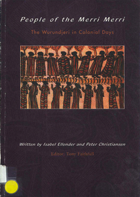
Book, Isabel Ellender et al, People of the Merri Merri : the Wurundjeri in colonial days, 2001
... People of the Merri Merri : the Wurundjeri in colonial days......Merri Merri...Victorian Aboriginal Corporation for Languages 33 Saxon Street Brunswick melbourne Woiwurung Woi wurrung Wurundjeri Wurundjeri willam Merri Merri William Thomas maps, b&w illustrations, colour This book looks at the earliest years of contact between Aborigines and Europeans in the Melbourne area. ...This book looks at the earliest years of contact between Aborigines and Europeans in the Melbourne area. The contact period saw the Wurundjerei-willam resisting, coping with and adapting to a new and alien culture. A degree of mutual respect seems to have existed, at least for a short time, of each other?s intentions. It appears that the settlement at Port Phillip did not encounter the degree of violence seen elsewhere.maps, b&w illustrations, colourwoiwurung, woi wurrung, wurundjeri, wurundjeri willam, merri merri, william thomas, -
 Greensborough Historical Society
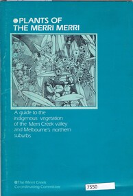
Book, Norman Anderson, Plants of the Merri Merri: a guide to the indigenous vegetation of the Merri Creek valley and Melbourne's northern suburbs, 1984
... Plants of the Merri Merri: a guide to the indigenous vegetation of the Merri Creek valley and Melbourne's northern suburbs...Greensborough Historical Society 34A Glenauburn Road Lower Plenty Lower Plenty melbourne Description of the indigenous vegetation of the Merri Creek valley, with a brief historical bbackground merri creek native flora 64 p., black & white illustrations Plants of the Merri Merri: a guide to the indigenous vegetation of the Merri Creek valley and Melbourne's northern suburbs Book Book Norman Anderson Merri Creek Co-ordinating Committee ...64 p., black & white illustrationsnon-fictionmerri creek, native flora -
 Merri-bek City Council
Photograph - Pigment inkjet print dry mounted to Dibond, Peta Clancy, here merri merri lies 8, 2024
... here merri merri lies 8...Recommendation The recommendation is to acquire either here merri merri lies 1 (2024) or here merri merri lies 6 (2024) by Dr Peta Clancy. ... -
 University of Melbourne, Burnley Campus Archives
Album - Colour prints, negatives and 35mm slides, Staff, Collection of Photographs Used by Staff, 1994-2000
... merri creek...mt ridley...energy education centre...student party...pot trial...centenial centre shop...arborists...plants...graduates...students...plant database...jill kellow...orchard...james hitchmough grasslands...horticulture shop...ruth beilin...upper merri creek...merri...Ruth Upper Merri Creek - negatives and prints; Merri Creek - negatives and prints; Merri Creek Panorama - prints; Merri Creek Posters 1995 - negatives and prints; Plants - negatives. 2. ...University of Melbourne, Burnley Campus Archives 500 Yarra Boulevard Richmond melbourne staff excursions teaching material merri creek mt ridley energy education centre student party pot trial centenial centre shop arborists plants graduates students plant database jill kellow orchard james hitchmough grasslands horticulture shop ruth beilin upper merri creek merri creek panorama merri creek posters Collection of photographs in envelopes which had belonged to staff members. ...Collection of photographs in envelopes which had belonged to staff members. Some are photographs from excursions, others are teaching material, plants. Some labelled: 1. Ruth Upper Merri Creek - negatives and prints; Merri Creek - negatives and prints; Merri Creek Panorama - prints; Merri Creek Posters 1995 - negatives and prints; Plants - negatives. 2. Western District Exhibition, labelled - negatives and prints of paintings; Mt Ridley (Excursion?) - negatives and prints; Energy Education Centre 15 November 1995; Gardens - Spring 1995 negatives (mostly James Hitchmough, Native Grasslands and Luffmann Ponds) Scanned; Student Party June 1994 - negatives; 3. Pot Trial - negatives and prints; Miscellaneous plant trials, Centenial Centre Shop, Arborists, Plants, Excursions - negatives; Excursions , 1 year 2000 - negatives and prints; Orchard (older) - black and white negatives and prints; Arborists - negatives and prints; 4. Staff, Graduate students - negatives and prints; Miscellaneous: Plants, - negatives, slides and prints. 7. Native Garden and other garden views - prints and negativesstaff, excursions, teaching material, merri creek, mt ridley, energy education centre, student party, pot trial, centenial centre shop, arborists, plants, graduates, students, plant database, jill kellow, orchard, james hitchmough grasslands, horticulture shop, ruth beilin, upper merri creek, merri creek panorama, merri creek posters -
 Ballarat Heritage Services
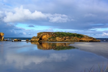
Photograph - Digital photographs, L.J. Gervasoni, Middle Island, Warrnambool, 2012
... ...Merri...Merri...Ballarat Heritage Services PO Box 2209 Bakery Hill Post Office goldfields victoria river mouth coast ocean island middle middle island warrnambool Merri Merri River Digital images of Middle Island Stingray Bay warrnambool Middle Island, Warrnambool Photograph Digital photographs L.J. ...Digital images of Middle Island Stingray Bay warrnamboolvictoria, river, mouth, coast, ocean, island, middle, middle island, warrnambool, merri, merri river -
 Flagstaff Hill Maritime Museum and Village
Photograph - Coastal Scene, Warrnambool South Primary School Centenary Committee, Viaduct to Warrnambool Breakwater - 1890, 1977
... Merri River bridge...Merri footbridge...Original Merri...Warrnambool Shipwreck Coast Flagstaff Hill Flagstaff Hill Maritime Museum Flagstaff Hill Maritime Village Warrnambool Breakwater Viaduct Viaduct Road Merri River bridge Merri footbridge Original Merri foodtridge Titan crane Warrnambool South Primary School Warrnambool South Primary School Centenary Commitee Centenary Committee 1890 1877 1877-1977 Lady Bay Port of Warrnambool Typed onto the label: "PRESENTED TO FLAGSTAFF HILL / BY THE SOUTH WARRNAMBOOL / PRIMARY SCHOOL CENTENARY / COMMITTEE / "VIADUCT TO / WARRNAMBOOL BREAKWATER" / - 1890 - " Photograph, black and white, mounted onto cardboard with a pasted-on label below the photograph. ...The local photograph shows the original footbridge across the Merri River near its mouth, the Viaduct road and the Warrnambool Breakwater with the Titan crane on it. The breakwater's construction was completed in 1890, the year this photograph was taken. The Viaduct has since been filled in to prevent water passing through the pylons, and the footbridge has been replaced. The photograph was presented to Flagstaff Hill on the centenary of South Warrnambool Primary School, 1877 to 1977, by the school's Warrnambool South Primary School Centenary Committee. The centenary was celebrated during August 12-13-14. The school was decommissioned in the 1990s.The photograph is locally significant for recording the completion of the Warrnambool Breakwater, for showing the original design of the Viaduct and for a clear view of the original footbridge across the Merri River. It also records the date of the presentation of the photograph celebrates the centenary of the 1877 to 1977 Warrnambool Sough Primary School.Photograph, black and white, mounted onto cardboard with a pasted-on label below the photograph. It shows the Merri River footbridge, the Viaduct, the Warrnambool Breakwater with the Titan crane, and the Port of Warrnambool. The label has an inscription. The photograph was taken in 1890 and was presented to Flagstaff Hill by the South Warrnambool Primary School's Centenary Committee ca. 1977. The photograph was taken in 1890 and was presented to Flagstaff Hill Maritime Museum by the South Warrnambool Primary School Centenary Committee in the Centenary year of the South Warrnambool Primary School;1977.Typed onto the label: "PRESENTED TO FLAGSTAFF HILL / BY THE SOUTH WARRNAMBOOL / PRIMARY SCHOOL CENTENARY / COMMITTEE / "VIADUCT TO / WARRNAMBOOL BREAKWATER" / - 1890 - "warrnambool, shipwreck coast, flagstaff hill, flagstaff hill maritime museum, flagstaff hill maritime village, warrnambool breakwater, viaduct, viaduct road, merri river bridge, merri footbridge, original merri foodtridge, titan crane, warrnambool south primary school, warrnambool south primary school centenary commitee, centenary committee, 1890, 1877, 1877-1977, lady bay, port of warrnambool -
 Eltham District Historical Society Inc
Booklet - Folder, Indigenous History, 2001
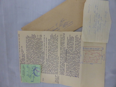
... Book review of People of the Merri Merri: the Wurundjeri in Colonial Days by Isabel Ellender and Peter Christiansen ...Eltham District Historical Society Inc 728 Main Rd Eltham melbourne Book review of People of the Merri Merri: the Wurundjeri in Colonial Days by Isabel Ellender and Peter Christiansen harry gilham collection indigenous history merri creek wurundjeri 1 pages Indigenous History Booklet Folder ...Book review of People of the Merri Merri: the Wurundjeri in Colonial Days by Isabel Ellender and Peter Christiansen 1 pagesharry gilham collection, indigenous history, merri creek, wurundjeri -
 Flagstaff Hill Maritime Museum and Village
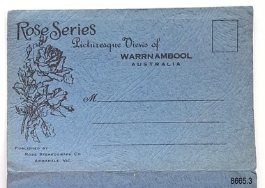
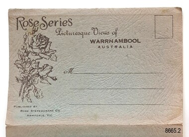
Postcard - Postcard Folder - scenes, George Rose, Rose Stereographic Company, Rose Series Picturesque Views of Warrnambool Australia [Warrnambool], 1880-1942
... Merri River footbridge...Merri River suspension bridge...suspension footbridge...Merri...Flagstaff Hill Maritime Museum and Village Great Ocean Road Shipwreck Coast Warrnambool Flagstaff Hill Flagstaff Hill Maritime Museum Flagstaff Hill Maritime Village Warramble postcard postcard folder Warrnambool Scenes Picturesque views of Warrnambool Picturesque views of Warramble Lady Bay Port of Warrnambool Breakwater Warrnambool Breakwater Viaduct Merri River footbridge Merri River suspension bridge suspension footbridge Merri River mouth Hopkins River mouth Proudfoot's Fanny Nelson Nelson's boatsheds Nelson's Boathouse boathouse Hopkins River boathouses Flett's boathouse Flett George Rose image of a rose Rose Series Rose Stereograph Co Rose Stereographic Company Lighograph Armadale Victoria Lady Bay beach beach scene Lower Light concrete footbridge 1922 footbridge Viaduct Road Rose postcard new concrete bridge 1945 1890 1922 small footbridge 1872 footbridge 1872 Merri River Estuary Stingray Bay postcards Image: [Rose with rosebud and leaves] Printed: "Rose Series / Picturesque Views of / WARRAMBOOL / AUSTRALIA" [correct spelling is WARRNAMBOOL] "PUBLISHED BY / ROSE STEREOGRAPH CO / ARMADALE. ...This postcard folder contains lithographs of photographs taken locally by Georg Rose between 1880 and 1942. He reproduced them at his company's premises, the Rose Stereographic Company at Armadale, Victoria. The postcard folder was purchased as a Warrnambool souvenir by the donor's parents around 1945 to 1950. Interestingly, the city on the cover is printed as "Warrambool", which is a location in New South Wales, but the postcards within all have the locations and text of Warrnambool. The photographs include the 'new' concrete bridge, built in 1922 to replace the original bridge, built in 1872. The boathouses belonging to Proudfoots and to Flett/Fanny Nelson are also pictured on the Hopkins River mouth. The twelve photographs included locations connected to other items in our Collection. The photographs are titled: - b. The Avenue and War Memorial. Warrnambool. Vic. c. The Blow-hole. Thunder Point. Warrnambool. Vic. d. Botanical Gardens. Warrnambool. Vic. e. Eagle Rock. Warrnambool. Vic. f. The New Concrete Bridge and Breakwater. Warrnambool. Vic. g. Liebig Street. Warrnambool. Vic. h. Looking to Thunder Point. Warrnambool. Vic. i. The Beach. Warrnambool. Vic. j. Hopkins Falls. Warrnambool. Vic. k. Shelly Beach. Warrnambool. Vic. l. The Mouth of the Hopkins River. Warrnambool. Vic. m. Panorama of Warrnambool. Vic. [Kepler Street towards Presbyterian Church on Spence St] George Rose, 1861-1942: - famous for his Late 19th and early 20th century photography. He was born in Clunes, Victoria, and was in his 20th year when he founded Rose Stereograph Company in 1880. He took the opportunity of a popular trend of the times to produce stereographs, pairs of almost duplicate photographs which appeared to be in 3D when viewed in a handheld stereo viewer. By the 1920s these lost their popularity, so he used his photographic skills to produce cards and postcards of scenes and people. The photographs in this postcard folder were taken between 1880 and 1942 by the renowned Victorian photographer George Rose. The locations match photographs and postcards in our collection that were taken at different times. A comparison between them shows the changes over time in the land and bay, the buildings and other structures, transportation and even the fashions of the times, building the story of our local history.This copy of a postcard folder has a blue-grey textured rectangular card cover with a sketch of a rose on the front along with the name of the postcard series. the location of the series' focus, the producer's details and lines for adding an address. The folded cover contains a long, concertinaed page with six titled photographs on each side, totalling twelve in all. Interestingly, the cover has the location name of "Warrambool", a place in NSW, instead of Warrnambool, the location of all of the photographs inside. The folder contains scenes from Warrnambool and nearby popular areas including Lady Bay, Port of Warrnambool, Warrnambool Breakwater, Viaduct, Merri River Footbridge, the Hopkins River Mouth, with Proudfoot’s and the Fanny Nelson/Flett boathouses. The cover has a sketch of a rose and inscriptions. The photographs for the lithographs were taken prior between 1880 and 1942 by well-known Victorian photographer, George Rose, Rose Stereograph Company of Armadale, Victoria.Image: [Rose with rosebud and leaves] Printed: "Rose Series / Picturesque Views of / WARRAMBOOL / AUSTRALIA" [correct spelling is WARRNAMBOOL] "PUBLISHED BY / ROSE STEREOGRAPH CO / ARMADALE. VIC." Printed lines (3) for an address. Printed rectangle [ ] for attaching a stamp.flagstaff hill maritime museum and village, great ocean road, shipwreck coast, warrnambool, flagstaff hill, flagstaff hill maritime museum, flagstaff hill maritime village, warramble, postcard, postcard folder, warrnambool scenes, picturesque views of warrnambool, picturesque views of warramble, lady bay, port of warrnambool, breakwater, warrnambool breakwater, viaduct, merri river footbridge, merri river suspension bridge, suspension footbridge, merri river mouth, hopkins river mouth, proudfoot's, fanny nelson, nelson's boatsheds, nelson's boathouse, boathouse, hopkins river boathouses, flett's boathouse, flett, george rose, image of a rose, rose series, rose stereograph co, rose stereographic company, lighograph, armadale victoria, lady bay beach, beach scene, lower light, concrete footbridge, 1922 footbridge, viaduct road, rose postcard, new concrete bridge, 1945, 1890, 1922, small footbridge, 1872 footbridge, 1872, merri river estuary, stingray bay, postcards -
 Flagstaff Hill Maritime Museum and Village
Postcard - Postcard Folder, scenes, George Rose, Rose Stereographic Company, Rose Series Picturesque Views of Warrnambool Australia, 1880-1942
... Merri River footbridge...Merri River suspension bridge...suspension footbridge...Merri...Flagstaff Hill Maritime Museum and Village Great Ocean Road Shipwreck Coast Warrnambool Flagstaff Hill Flagstaff Hill Maritime Museum Flagstaff Hill Maritime Village Warramble postcard postcard folder Warrnambool Scenes Picturesque views of Warrnambool Picturesque views of Warramble Lady Bay Port of Warrnambool Breakwater Warrnambool Breakwater Viaduct Merri River footbridge Merri River suspension bridge suspension footbridge Merri River mouth Hopkins River mouth Proudfoot's Fanny Nelson Nelson's boatsheds Nelson's Boathouse boathouse Hopkins River boathouses Flett's boathouse Flett George Rose image of a rose Rose Series Rose Stereograph Co Rose Stereographic Company Lighograph Armadale Victoria Lady Bay beach beach scene Lower Light concrete footbridge 1922 footbridge Viaduct Road Rose postcard new concrete bridge 1945 1890 1922 small footbridge 1872 footbridge 1872 Merri River Estuary Stingray Bay postcards Image: [Rose with rosebud and leaves] Printed: "Rose Series / Picturesque Views of / WARRNAMBOOL / AUSTRALIA" "PUBLISHED BY / ROSE STEREOGRAPH CO / ARMADALE. ...GEORGE ROSE 1861-1942: - George Rose was a well-known Victorian photographer, famous for his late 19th and early 20th century photography. He was born in Clunes, Victoria, and was in his 20th year when he founded Rose Stereograph Company in 1880. He took the opportunity of a popular trend of the times to produce stereographs, pairs of almost duplicate photographs that appeared in 3D when viewed in a handheld stereo viewer. By the 1920s, these lost their popularity, so he used his photographic skills to produce cards and postcards of scenes and people. The twelve photographs in the Rose postcard folders include locations connected to other items in our Collection, including the Valentine postcard folder in this set. The photographs are titled: - . The Avenue and War Memorial. Warrnambool. Vic. . The Blow-hole. Thunder Point. Warrnambool. Vic. . Botanical Gardens. Warrnambool. Vic. . Eagle Rock. Warrnambool. Vic. . The New Concrete Bridge and Breakwater. Warrnambool. Vic. . Liebig Street. Warrnambool. Vic. . Looking to Thunder Point. Warrnambool. Vic. . The Beach. Warrnambool. Vic. . Hopkins Falls. Warrnambool. Vic. . Shelly Beach. Warrnambool. Vic. . The Mouth of the Hopkins River. Warrnambool. Vic. . Panorama of Warrnambool, Vic. [Kepler Street towards Presbyterian Church on Spence St] The photographs in this postcard folder were taken between 1880 and 1942 by the renowned Victorian photographer George Rose. The locations match photographs and postcards in our collection that were taken at different times. A comparison between them shows the changes over time in the land and bay, the buildings and other structures, transportation and even the fashions of the times, building the story of our local history.Postcard folder, Rose Series, blue cover. One of a set of three containing images of Warrnambool and district before 1942. Green folder, textured cardboard folder containing a Z-folded strip of white matte photographic paper with six black and white photographs on each side. Titles are printed below the images. The folder is secured by placing two tabs into two slots on the back cover to hold the cover in place and create an envelope shape. Three horizontal lines are printed on the front for the receiver’s address. There is a logo of a long-stemmed rose on the left side and inscriptions on the front cover. The lithograph photographs were taken between 1880 and 1942 by well-known Victorian photographer George Rose and published by Rose Stereograph Company of Armadale, Victoria. The folder contains scenes of popular areas at Warrnambool and nearby locations including Lady Bay, the Port of Warrnambool, the Warrnambool Breakwater, the Viaduct, the Merri River Footbridge, the Hopkins River Mouth, and Proudfoot’s and the Fanny Nelson/Flett boathouses. Image: [Rose with rosebud and leaves] Printed: "Rose Series / Picturesque Views of / WARRNAMBOOL / AUSTRALIA" "PUBLISHED BY / ROSE STEREOGRAPH CO / ARMADALE. VIC." flagstaff hill maritime museum and village, great ocean road, shipwreck coast, warrnambool, flagstaff hill, flagstaff hill maritime museum, flagstaff hill maritime village, warramble, postcard, postcard folder, warrnambool scenes, picturesque views of warrnambool, picturesque views of warramble, lady bay, port of warrnambool, breakwater, warrnambool breakwater, viaduct, merri river footbridge, merri river suspension bridge, suspension footbridge, merri river mouth, hopkins river mouth, proudfoot's, fanny nelson, nelson's boatsheds, nelson's boathouse, boathouse, hopkins river boathouses, flett's boathouse, flett, george rose, image of a rose, rose series, rose stereograph co, rose stereographic company, lighograph, armadale victoria, lady bay beach, beach scene, lower light, concrete footbridge, 1922 footbridge, viaduct road, rose postcard, new concrete bridge, 1945, 1890, 1922, small footbridge, 1872 footbridge, 1872, merri river estuary, stingray bay, postcards -
 Flagstaff Hill Maritime Museum and Village
Postcard - Postcard Folder set, George Rose, Rose Stereographic Company, 1880-1942
... Merri River footbridge...Merri River suspension bridge...suspension footbridge...Merri...Flagstaff Hill Maritime Museum and Village Great Ocean Road Shipwreck Coast Warrnambool Flagstaff Hill Flagstaff Hill Maritime Museum Flagstaff Hill Maritime Village Warramble postcard postcard folder Warrnambool Scenes Picturesque views of Warrnambool Picturesque views of Warramble Lady Bay Port of Warrnambool Breakwater Warrnambool Breakwater Viaduct Merri River footbridge Merri River suspension bridge suspension footbridge Merri River mouth Hopkins River mouth Proudfoot's Fanny Nelson Nelson's boatsheds Nelson's Boathouse boathouse Hopkins River boathouses Flett's boathouse Flett George Rose image of a rose Rose Series Rose Stereograph Co Rose Stereographic Company Lighograph Armadale Victoria Lady Bay beach beach scene Lower Light concrete footbridge 1922 footbridge Viaduct Road Rose postcard new concrete bridge 1945 1890 1922 small footbridge 1872 footbridge 1872 Merri River Estuary Stingray Bay postcards Shipwrecked coast Maritime Museum Souvenir Warrnambool local scenes Hopkins River Botanic Gardens Soldiers’ Memorial Pier Post Office Municipal Buildings Merri River Proudfoot’s The Cliffs at Shelly Beach The Road to Sandy Beach tourism photographs visitors travel scenes local history mid-20th century 1940s 1950s Rose Stereograph Co Armadale. ...Each postcard folder in this set has no address, message or postage stamp. Postcard folders such as these were popular as holiday souvenirs in the early to mid-20th century and were kept in good condition by collectors. The size is convenient for posting to friends and relatives and packing as holiday luggage. Postcards in the early-to-mid-19th century were an inexpensive way to remember and share holiday scenes, as few people could afford a camera and the price of developing the photographs. The images on these postcards were produced from black and white lithographs of photographs taken at Warrnambool and the surrounding district during the early to mid-20th century. Publishing firms such as Melbourne-based Valentine and Rose purchased photographs from local photographers and reproduced them for sale. This set of postcard folders shows that more than one publishing company had access to the same or almost the same images. The photographs include street scapes, the Warrnambool Breakwater and Pier, Botanical Gardens, beach scenes, cliff formations, the Hopkins River, municipal buildings, the Post Office and the Soldiers’ Memorial. The postcard folders in this set of three are significant as a record of local history from the late 19th century to the mid-20th century. The locations of the images match photographs and postcards in our collection that were taken at different times and provide a historical record of the Warrnambool and southwest Victorian locations, growth and changes.. The images record changes in the coastline, land, bay, buildings and other structures, roads, transportation and even the fashions of the times. Set of three postcard folders containing black and white images of photographed scenes showcasing Warrnambool and district between 1880 and 1942. The images were produced from lithographs of the original photographs and are printed on both sides of long strips of white photographic paper that are Z-folded into covers of textured card. Some of the images are repeated in all three folders. Folder 8665.1 - the cream-coloured folder was produced by The Valentine Publishing Co. Pty. Ltd. Melbourne and contains 15 photographs, some of which are also in the blue and the green folders. Folders 8665.2, the green folder, and 8665.3, the blue folder, were published by Rose Stereograph Co, Armadale, Vic. Each contains the same twelve images, but they are presented in a different order. flagstaff hill maritime museum and village, great ocean road, shipwreck coast, warrnambool, flagstaff hill, flagstaff hill maritime museum, flagstaff hill maritime village, warramble, postcard, postcard folder, warrnambool scenes, picturesque views of warrnambool, picturesque views of warramble, lady bay, port of warrnambool, breakwater, warrnambool breakwater, viaduct, merri river footbridge, merri river suspension bridge, suspension footbridge, merri river mouth, hopkins river mouth, proudfoot's, fanny nelson, nelson's boatsheds, nelson's boathouse, boathouse, hopkins river boathouses, flett's boathouse, flett, george rose, image of a rose, rose series, rose stereograph co, rose stereographic company, lighograph, armadale victoria, lady bay beach, beach scene, lower light, concrete footbridge, 1922 footbridge, viaduct road, rose postcard, new concrete bridge, 1945, 1890, 1922, small footbridge, 1872 footbridge, 1872, merri river estuary, stingray bay, postcards, shipwrecked coast, maritime museum, souvenir, warrnambool local scenes, hopkins river, botanic gardens, soldiers’ memorial, pier, post office, municipal buildings, merri river, proudfoot’s, the cliffs at shelly beach, the road to sandy beach, tourism, photographs, visitors, travel, scenes, local history, mid-20th century, 1940s, 1950s, rose stereograph co armadale. vic, valentine publishing co. pty. ltd melbourne, valentine publishing co. pty. ltd sydney -
 Flagstaff Hill Maritime Museum and Village
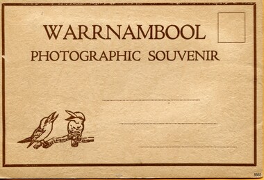
Postcard - Postcard Folder, scenes, Valentine & Sons Co. Publishing Ltd, Warrnambool Photographic Souvenir, Early-to-mod 20th century
... Merri River footbridge...Merri River suspension bridge...suspension footbridge...Merri...Flagstaff Hill Maritime Museum and Village Great Ocean Road Shipwreck Coast Warrnambool Flagstaff Hill Flagstaff Hill Maritime Museum Flagstaff Hill Maritime Village Warramble postcard postcard folder Warrnambool Scenes Picturesque views of Warrnambool Picturesque views of Warramble Lady Bay Port of Warrnambool Breakwater Warrnambool Breakwater Viaduct Merri River footbridge Merri River suspension bridge suspension footbridge Merri River mouth Hopkins River mouth Proudfoot's Fanny Nelson Nelson's boatsheds Nelson's Boathouse boathouse Hopkins River boathouses Flett's boathouse Flett George Rose image of a rose Rose Series Rose Stereograph Co Rose Stereographic Company Lighograph Armadale Victoria Lady Bay beach beach scene Lower Light concrete footbridge 1922 footbridge Viaduct Road Rose postcard new concrete bridge 1945 1890 1922 small footbridge 1872 footbridge 1872 Merri River Estuary Stingray Bay postcards concertina fold Z fold Shipwrecked coast Maritime Museum Souvenir Warrnambool local scenes photography local history tourism photographs visitors travel scenes mid-20th century 1940s 1950s Z-fold 1880s collection correspondence Valentine Publishing Co. ...This postcard folder is one of three in a set of postcards that were published in Victoria, Australia, and collected together. The Valentine Publishing Co. Pty. Ltd. produced this folder. Valentine and Sons was a printing and photography business based in Dundee, Scotland, and in Canada. In the early 1900s, at the height of the postcard craze, the firm published large numbers of postcards in the U.K., Canada, U.S., Australia and South Africa. From around 1900 or earlier, the firm bought many lithographic images for its postcards from local and national photographers who sold publishing rights to Valentines, and the business was famous for publishing photographs of popular sites worldwide. Postcard titles in this folder include many of those in the Rose postcard folders plus the following titles that are not duplicated. . Municipal Buildings and Post Office . Soldiers’ Memorial . Hopkins River . The Cliffs at Shelly Beach . The Road to Sandy Beach . The Breakwater and Pier This Valentine postcard folder was produced in Australia. It includes pictures from the early-to-mid 20th century. It is one of three in a set, with images of the same locations as other images in our collection but at different periods in time. Each postcard records a moment in history and is significant as a way to compare and show the changes in the local environment and community, building a story of the local history. The images record changes in the coastline, land, bay, buildings and other structures, roads, transportation and even the fashions of the times.Postcard folder, Valentine Publishing, cream cover. One of a set of three displaying images of Warrnambool and district around the mid-20th century. Print on the front and back covers is in brown ink. The front has an image of two laughing kookaburras on a branch, three address lines and an outline for a postage stamp. The back cover has the publisher’s details and a line for a return address. The cover opens like a book, and then the double-sided, Z-folded page of photographs drops downward. Titles are printed below each of the fifteen black and white photographs inside. The folder is secured on the back cover by placing a tab into a slot. The folder was produced by The Valentine Publishing Co. Pty. Ltd. Melbourne“WARRNAMBOOL / PHOTOGRAPHIC SOUVENIR” Symbol: [Two facing kookaburras standing on a branch with beaks open] “Published by The Valentine Publishing Co. Pty. Ltd. Melbourne” flagstaff hill maritime museum and village, great ocean road, shipwreck coast, warrnambool, flagstaff hill, flagstaff hill maritime museum, flagstaff hill maritime village, warramble, postcard, postcard folder, warrnambool scenes, picturesque views of warrnambool, picturesque views of warramble, lady bay, port of warrnambool, breakwater, warrnambool breakwater, viaduct, merri river footbridge, merri river suspension bridge, suspension footbridge, merri river mouth, hopkins river mouth, proudfoot's, fanny nelson, nelson's boatsheds, nelson's boathouse, boathouse, hopkins river boathouses, flett's boathouse, flett, george rose, image of a rose, rose series, rose stereograph co, rose stereographic company, lighograph, armadale victoria, lady bay beach, beach scene, lower light, concrete footbridge, 1922 footbridge, viaduct road, rose postcard, new concrete bridge, 1945, 1890, 1922, small footbridge, 1872 footbridge, 1872, merri river estuary, stingray bay, postcards, concertina fold, z fold, shipwrecked coast, maritime museum, souvenir, warrnambool local scenes, photography, local history, tourism, photographs, visitors, travel, scenes, mid-20th century, 1940s, 1950s, z-fold, 1880s, collection, correspondence, valentine publishing co. pty. ltd melbourne, valentine publishing co. pty. ltd sydney, municipal buildings and post office, soldiers’ memorial, hopkins river, the cliffs at shelly beach, the road to sandy beach, the breakwater and pier -
 Flagstaff Hill Maritime Museum and Village
Postcard - Postcard Folder, scenes, George Rose, Rose Stereographic Company, Rose Series, Picturesque Views of Warrnambool Australia, 1880-1942
... Merri River footbridge...Merri River suspension bridge...suspension footbridge...Merri...Flagstaff Hill Maritime Museum and Village Great Ocean Road Shipwreck Coast Warrnambool Flagstaff Hill Flagstaff Hill Maritime Museum Flagstaff Hill Maritime Village Warramble postcard postcard folder Warrnambool Scenes Picturesque views of Warrnambool Lady Bay Port of Warrnambool Breakwater Warrnambool Breakwater Viaduct Merri River footbridge Merri River suspension bridge suspension footbridge Merri River mouth Hopkins River mouth Proudfoot's Fanny Nelson Nelson's boatsheds Nelson's Boathouse boathouse Hopkins River boathouses Flett's boathouse Flett George Rose image of a rose Rose Series Rose Stereograph Co Rose Stereographic Company Lighograph Armadale Victoria Lady Bay beach beach scene Lower Light concrete footbridge 1922 footbridge Viaduct Road Rose postcard new concrete bridge 1945 1890 1922 small footbridge 1872 footbridge 1872 Merri River Estuary Stingray Bay postcards green-grey postcard folder Shipwrecked coast Maritime Museum Souvenir Warrnambool local scenes photography local history tourism photographs visitors travel scenes mid-20th century 1940s 1950s concertina fold Z-fold 1880s collection correspondence Rose Stereograph Co Armadale Victorian photographer Soldiers’ Memorial Hopkins River The Cliffs at Shelly Beach The Road to Sandy Beach Pier Botanic Gardens Post Office Municipal Buildings Merri River Proudfoot’s Image: [Rose with rosebud and leaves] Printed: "Rose Series / Picturesque Views of / WARRNAMBOOL / AUSTRALIA" "PUBLISHED BY / ROSE STEREOGRAPH CO / ARMADALE. ...GEORGE ROSE 1861-1942: - George Rose was a well-known Victorian photographer, famous for his late 19th and early 20th century photography. He was born in Clunes, Victoria, and was in his 20th year when he founded Rose Stereograph Company in 1880. He took the opportunity of a popular trend of the times to produce stereographs, pairs of almost duplicate photographs that appeared in 3D when viewed in a handheld stereo viewer. By the 1920s, these lost their popularity, so he used his photographic skills to produce cards and postcards of scenes and people. The twelve photographs in the Rose postcard folders include locations connected to other items in our Collection, including the Valentine postcard folder in this set. The photographs are titled: - . The Avenue and War Memorial. Warrnambool. Vic. . The Blow-hole. Thunder Point. Warrnambool. Vic. . Botanical Gardens. Warrnambool. Vic. . Eagle Rock. Warrnambool. Vic. . The New Concrete Bridge and Breakwater. Warrnambool. Vic. . Liebig Street. Warrnambool. Vic. . Looking to Thunder Point. Warrnambool. Vic. . The Beach. Warrnambool. Vic. . Hopkins Falls. Warrnambool. Vic. . Shelly Beach. Warrnambool. Vic. . The Mouth of the Hopkins River. Warrnambool. Vic. . Panorama of Warrnambool, Vic. [Kepler Street towards Presbyterian Church on Spence St] This postcard folder shows scenes and places of interest in and around Warrnambool. The George Rose postcard folders in this set were produced in Victoria and include pictures taken by the renowned photographer between 1880 and 1942. Other postcards in our collection have photographs of the same or similar locations at different periods in time. Each postcard records a moment in history and is significant as a way to compare and show the changes in the local environment and community, building a story of the local history. The images record changes in the coastline, land, bay, buildings and other structures, roads, transportation and even the fashions of the times. This copy folder is one of a set of three. This folder has a green-grey textured rectangular card cover with a sketch of a rose on the front. The cover also contains the name of the postcard series, the location of the series' focus, the producer's details, and lines for adding an address. The folded cover contains a long, concertinaed page with six titled photographs on each side, totalling twelve. The folder contains scenes from Warrnambool and nearby popular areas, including Lady Bay, the Port of Warrnambool, the Warrnambool Breakwater, the Viaduct, the Merri River Footbridge, the Hopkins River Mouth, and Proudfoot’s and the Fanny Nelson/Flett boathouses. The cover has a sketch of a rose and inscriptions. The lithograph photographs were taken between 1880 and 1942 by well-known Victorian photographer George Rose, Rose Stereograph Company of Armadale, Victoria.Image: [Rose with rosebud and leaves] Printed: "Rose Series / Picturesque Views of / WARRNAMBOOL / AUSTRALIA" "PUBLISHED BY / ROSE STEREOGRAPH CO / ARMADALE. VIC."flagstaff hill maritime museum and village, great ocean road, shipwreck coast, warrnambool, flagstaff hill, flagstaff hill maritime museum, flagstaff hill maritime village, warramble, postcard, postcard folder, warrnambool scenes, picturesque views of warrnambool, lady bay, port of warrnambool, breakwater, warrnambool breakwater, viaduct, merri river footbridge, merri river suspension bridge, suspension footbridge, merri river mouth, hopkins river mouth, proudfoot's, fanny nelson, nelson's boatsheds, nelson's boathouse, boathouse, hopkins river boathouses, flett's boathouse, flett, george rose, image of a rose, rose series, rose stereograph co, rose stereographic company, lighograph, armadale victoria, lady bay beach, beach scene, lower light, concrete footbridge, 1922 footbridge, viaduct road, rose postcard, new concrete bridge, 1945, 1890, 1922, small footbridge, 1872 footbridge, 1872, merri river estuary, stingray bay, postcards, green-grey postcard folder, shipwrecked coast, maritime museum, souvenir, warrnambool local scenes, photography, local history, tourism, photographs, visitors, travel, scenes, mid-20th century, 1940s, 1950s, concertina fold, z-fold, 1880s, collection, correspondence, rose stereograph co armadale, victorian photographer, soldiers’ memorial, hopkins river, the cliffs at shelly beach, the road to sandy beach, pier, botanic gardens, post office, municipal buildings, merri river, proudfoot’s -
 Warrnambool and District Historical Society Inc.
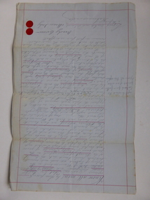
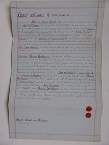
Document, Gauley contracts .1 & .2, C 1878
... Warrnambool and District Historical Society Inc. 2 Gilles Street (south of Merri St) Warrnambool great-ocean-road In 1858 a tramway was constructed to move goods between Warrnambool township and jetty on Lady Bay which was over a mile away The terminus was established on the southern side of Merri Street. and the track went around the edge of Lake Pertobe reserve. ...In 1858 a tramway was constructed to move goods between Warrnambool township and jetty on Lady Bay which was over a mile away The terminus was established on the southern side of Merri Street. and the track went around the edge of Lake Pertobe reserve. Large stores were also built near where the present railway station is situated to hold produce and carriages. These documents relate to contracts between Marion Gauley ,contractor of Warrnambool and the borough of Warrnambool for the operation of horse work with the tramway. John McDermid sadler,and William Stevens farmer of Russell's Creek are acting as surety for the contract.The tramway was an important part of Warrnambool's infrastructure and history and the documents also include names of local people. Of particular interest is the fact that the contract in this case was given to a woman which would have been a little uncommon at that time.001259.1 Pale blue lined paper with red lined outline.Hand written in black pen with names and some other words underlined in red. Two signatures on bottom right with red seal beside each. Witness signature below on left hand side. One page only 001259.2 Pale blue lined paper with red lined outline.Hand written in black pen with names and some other words underlined in red. Two signatures on bottom right with red seal beside each. Witness signature below on left hand side. Of the four pages of the document , only the first page is used. 001259.1 Signed Roady Carew and Moses Daly. Richard Daly is crossed out in the document and Marion Gauley is inserted in greylead. September 1878 001259.2 John McDermid saddler William Stevens, Marion Gauley. Ninth of December 1878. warrnambool, warrnambool tramway, marion gauley, john mcdermid, william stevens -
 Warrnambool and District Historical Society Inc.
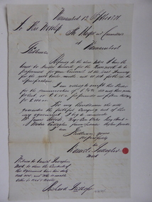
Document, Warrnambool Tramways-William Bell, C 1881
... Warrnambool and District Historical Society Inc. 2 Gilles Street (south of Merri St) Warrnambool great-ocean-road In 1858 a tramway was constructed to move goods between Warrnambool township and jetty on Lady Bay which was over a mile away The terminus was established on the southern side of Merri Street. and the track went around the edge of Lake Pertobe reserve. ...In 1858 a tramway was constructed to move goods between Warrnambool township and jetty on Lady Bay which was over a mile away The terminus was established on the southern side of Merri Street. and the track went around the edge of Lake Pertobe reserve. Large stores were also built near where the present railway station is situated to hold produce and carriages.This document is is a surety between John McDermit a saddler of Liebig Street Warrnambool along with Henry Phillips hay and corn dealer of Liebig Street Warrnambool, acting as surety in the amount of fifty pounds to William Bell a contractor to perform horse work for the Warrnambool tramways. for a period of one year, 1881-1882. This contract has a strong historical link to one of Warrnambool's earliest infrastructure projects . It contains the names of local people and provides an insight into the links between people and the types of work they undertook Pale blue lined paper with red lined outline.Hand written in black pen with names and some other words underlined in red. Two signatures on bottom right with red seal beside each. Witness signature below on left hand side. Of the four pages of the document , only the first page is used.Signed John McDermid, Henry Phillips. 1st October 1881.warrnambool,, warrnambool history, warrnambool tramways, william bell contract,, john mcdermid, henry phillips -
 Warrnambool and District Historical Society Inc.
Document, Gallagher, C 1881
... Warrnambool and District Historical Society Inc. 2 Gilles Street (south of Merri St) Warrnambool great-ocean-road In 1858 a tramway was constructed to move goods between Warrnambool township and jetty on Lady Bay which was over a mile away The terminus was established on the southern side of Merri Street. and the track went around the edge of Lake Pertobe reserve. ...In 1858 a tramway was constructed to move goods between Warrnambool township and jetty on Lady Bay which was over a mile away The terminus was established on the southern side of Merri Street. and the track went around the edge of Lake Pertobe reserve. Large stores were also built near where the present railway station is situated to hold produce and carriages. These documents relate to the contract to perform the horse work for the tramway for a period of one year. The horse work involved the transporting of goods by horse drawn tram trucks, all repairs to the tracks , shunting and delivery duties. The tramway operated from 7 am to 6 pm six days a week and a team of six horses was required to perform the work.The tramway was an important part of Warrnambool's infrastructure and history and the documents also include names of local people.001261.1 Pale blue lined paper with red lined outline.Hand written in black pen with names and some other words underlined in red. Two signatures on bottom right with red seal beside each. Witness signature below on left hand side. Of the four pages of the document , only the first page is used. 001261.2 Cream paper lined in blue with heavy black ink writing. A red seal attached beside the tenderer's mark and name. on right side of page. Witness's signature at bottom centre of page.001261.1 James Roberts hay and corn dealer ,Fairy Street Warrnambool, Martin Callaghanfarmer and contractor Raglan Parade Warrnambool. Daniel Gallagher, contractor of Warrnambool. September 1881. 001261.1 Daniel Gallagher .James Roberts Martin Callaghan September 12, 1881.warrnambool, warrnambool history, daniel gallagher, james roberts -
 Warrnambool and District Historical Society Inc.
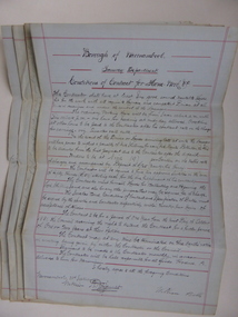
Document, Conditions of contract for Horse work Tramway Department, C1881
... Warrnambool and District Historical Society Inc. 2 Gilles Street (south of Merri St) Warrnambool great-ocean-road In 1858 a tramway was constructed to move goods between Warrnambool township and jetty on Lady Bay which was over a mile away The terminus was established on the southern side of Merri Street. and the track went around the edge of Lake Pertobe reserve. ...In 1858 a tramway was constructed to move goods between Warrnambool township and jetty on Lady Bay which was over a mile away The terminus was established on the southern side of Merri Street. and the track went around the edge of Lake Pertobe reserve. Large stores were also built near where the present railway station is situated to hold produce and carriages. According to these documents , the horses were required for many different tasks in the operation of the tramways including the moving of freight, removal of sand from the area, shunting of trucks and ballasting and repairing lines when necessary.The contractors had a list of conditions imposed including the provision of six horses of strong working ability and sufficient finances. The contract period was for 1 year and payment was monthly in arrears and hours of operation were from 7 am to 6 pm. These handwritten documents provide an insight into the type of work done in the early days of Warrnambool and the working conditions at the time. Five folded grey paper with red lines around edges. Written in black ink. Only front page of each piece has writing on it. 001262.1 Borough of Warrnambool Tramway Department Specification of Duties Contractor for Horse Work Signed William Bell 28/09/1881 001262.2 Borough of Warrnambool Tramway Department Conditions of contract for Horse Work. Signed Daniel Gallagher 20/09/1881 001262.3 Borough of Warrnambool Tramway Department Specification of Duties Contractor for Horse Work Signed Daniel Gallagher 20/09/1881. 001262.4 Borough of Warrnambool Tramway Department Specification of Duties Contractor for Horse Work Signed Michl Daly 5th September 1878 crossed out 001262.5 Borough of Warrnambool Tramway Department Conditions of contract for Horse Work Signed William Bell 28/09/1881warrnambool, warrnambool tramway, horse work, tramway contract -
 Warrnambool and District Historical Society Inc.
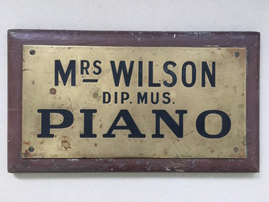
Name Plate, Mrs Wilson Piano, C mid 20th Century
... Warrnambool and District Historical Society Inc. 2 Gilles Street (south of Merri St) Warrnambool great-ocean-road We have limited information on Mrs Wilson, piano teacher except that a Mrs A Wilson operated from Merri Street in 1904. ...We have limited information on Mrs Wilson, piano teacher except that a Mrs A Wilson operated from Merri Street in 1904. Plaques such as these were hung outside premises to denote where people could access services and were often used by professional people and services. A link to one of Warrnambool's early music teachers.Small brass plate screwed to brown painted wooden board. Rectangular. Metal is stamped with name and details and filled in black.Mrs Wilson Dip Mus Piano. Rennie and Dodds 92 Little Collins St stamped on R H bottom corner . gauranteed filling stamped on lower left edge.warrnambool, mrs wilson piano teacher, mrs wilson pianoforte teacher, warrnambool pianoforte teachers 1904 -
 Warrnambool and District Historical Society Inc.
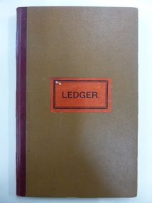
Administrative record - Warrnambool Waterworks Newspaper Cuttings, 1891 to 1917
... Merri St) Warrnambool great-ocean-road This ledger contains newspaper cuttings form The Warrnambool Standard newspaper from May 1891 to October 1917. The cuttings are reports of meetings of the Warrnambool Waterworks Trust. In the early days of Warrnambool domestic water and water for fire suppression was supplied by tanks, wells and springs. In the 1870s various schemes were proposed to find a better supply of water. In 1891 the Warrnambool Waterworks Trust was formed using water from the Merri ...This ledger contains newspaper cuttings form The Warrnambool Standard newspaper from May 1891 to October 1917. The cuttings are reports of meetings of the Warrnambool Waterworks Trust. In the early days of Warrnambool domestic water and water for fire suppression was supplied by tanks, wells and springs. In the 1870s various schemes were proposed to find a better supply of water. In 1891 the Warrnambool Waterworks Trust was formed using water from the Merri River. This system lasted until 1939 when the Warrnambool water supply came from the Otway ranges. This system is still the water supply for Warrnambool today. The cuttings in this ledger will be useful for research.This is a ledger with a brown mottled cover and a leather spine and leather corners. The spine is partly detached. The front cover has a label pasted on it. The pages originally had hand written entries (The Minutes of a Warrnambool organisation). Newspaper cuttings have been pasted over the original writing. Warrnambool Waterworks Trust Newspaper Reports From 19th May 1891 To --- warrnambool waterworks trust, warrnambool water supply -
 Warrnambool and District Historical Society Inc.
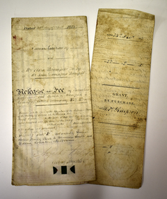
Legal record - Two documents regarding purchase and sale of land, George Barber, Port Fairy solicitor, early 1850s
... Merri River and the Mortlake Road, north of Warrnambool. The cost was 90 pounds. The second document is dated 1853 and shows that Thomas Simpson sold this Merri River allotment of 22 acres to Eliza Bromfield, in conjunction with her husband, John Davenport Bromfield, for the sum of 110 pounds. ...Merri St) Warrnambool great-ocean-road Thes two documents deal with the purchase and sale of land near Warrnambool by Thomas Simpson. The first document, called a Grant by Purchase, is dated 1852 and shows that Thomas Simpson purchased from the Crown, Allotment 146 (22 acres two roods) adjoining the property of Wollaston on the Merri River and the Mortlake Road, north of Warrnambool. The cost was 90 pounds. The second document is dated 1853 and shows that Thomas Simpson sold this Merri ...Thes two documents deal with the purchase and sale of land near Warrnambool by Thomas Simpson. The first document, called a Grant by Purchase, is dated 1852 and shows that Thomas Simpson purchased from the Crown, Allotment 146 (22 acres two roods) adjoining the property of Wollaston on the Merri River and the Mortlake Road, north of Warrnambool. The cost was 90 pounds. The second document is dated 1853 and shows that Thomas Simpson sold this Merri River allotment of 22 acres to Eliza Bromfield, in conjunction with her husband, John Davenport Bromfield, for the sum of 110 pounds. The property of Wollaston was owned by the Manifold family and in the 1850s was leased to William Simpson, the brother of Thomas who had an adjoining property called Wooramoota. John Davenport Bromfield was a Colac farmer who played a prominent part in the early history of that town. His brother James Astley Bromfield, an early chemist in Warrnambool is important in Warrnambool's history.These two items are of considerable significance because they are amongst the earliest legal documents we have connected to Warrnambool's history and because they concern three early pioneers of the district. They also have a connection to Wollaston, an important early property in the Warrnambool district..1 A piece of light parchment paper, stained with age and folded in three places. It contains printed and handwritten material, a copy of a signature and a white seal. .2 A piece of parchment paper folded in half and then folded again in two places. It contains ruled red lines, handwritten material in black ink and the remains of a red seal. The top of the first page has a cut-out fluted pattern.wollaston, john davenport bromfield, thomas simpson, eliza bromfield, george barber solicitor -
 Warrnambool and District Historical Society Inc.
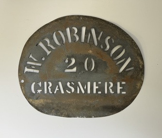
Functional object - Robinson Farm Labelling Stencil, c.1950
... Merri St) Warrnambool great-ocean-road This stencil has been made to label packaged produce (wool bales, packaged meat etc) from a farm in Grasmere, near Warrnambool. The name, W. Robinson, suggests that this is William Robinson the son of James and Jane Robinson. James Robinson came to Australia in 1857 and he and his family farmed at Springvale at Hopkins Point, then at what was termed 'Manning's old Purnim Farm' on the Merri ...This stencil has been made to label packaged produce (wool bales, packaged meat etc) from a farm in Grasmere, near Warrnambool. The name, W. Robinson, suggests that this is William Robinson the son of James and Jane Robinson. James Robinson came to Australia in 1857 and he and his family farmed at Springvale at Hopkins Point, then at what was termed 'Manning's old Purnim Farm' on the Merri Rive at Grasmere (the Manning brothers, Frederick and John were early farmers in the district). The Robinson brothers, James and Stuart were well-known in the Warrnambool district as champion ploughmen. James's son, William married firstly Christina MacLennan and then Elizabeth Neale of Tooram, Allansford. William died in 1959 but the stencil was probably used on the property after his death. This farm stencil is of interest as a memento of farming at Grasmere in the first half of the 20th century.This is a metal stencil, oval in shape. It has letters cut out in the metal for stencilling purposes. It has been painted or sprayed and is rusted in places.W. Robinson 20 Grasmerewilliam robinson grasmere, manning's purnim farm -
 Warrnambool and District Historical Society Inc.
Document - Documents (3) of Farnham Cheese and Butter factory, 1890s (originals)
... Merri St) Warrnambool great-ocean-road These three sheets are copies of the originals and relate to the establishment of the Farnham Cheese and Butter Factory in Dennington (Warrnambool). The name 'Farnham' is the name of the Special Survey in the area first purchased by William Rutledge and also the name of the Rutledge property at Dennington. In 1889 WIlliam Rutledge (Junior) and Thomas Palmer established the Farnham Cheese and Butter Factory on the banks of the Merri ...These three sheets are copies of the originals and relate to the establishment of the Farnham Cheese and Butter Factory in Dennington (Warrnambool). The name 'Farnham' is the name of the Special Survey in the area first purchased by William Rutledge and also the name of the Rutledge property at Dennington. In 1889 WIlliam Rutledge (Junior) and Thomas Palmer established the Farnham Cheese and Butter Factory on the banks of the Merri River at Dennington. In 1890 they sold the factory to a farmers' co-operative. Farnham had a high reputationfor butter=making when the factory was in existence. The factory was bought out by Nestles about 1909 with that company establishing its factory on the same area.in 1911. These documents are of interest as the Farnham Cheese and Butter Factory was one of the earliest of its type in the Western District and won a Gold Medal in 1909 for butter-making at the Islington Dairy Show in competition with other butter-making countries in the world..1 sheet of paper with black and white map showing location of factory in Dennington (copy) .2 An A3 size piece of paper with a sketch map and typed material showing a Certificate of Title (copy) .3 An 3 size piece of paper with a sketch map and typed material showing a Certificate of Title (copy)farnham cheese and butter factory, nestles factory warrnambool -
 Warrnambool and District Historical Society Inc.
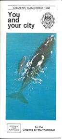
Booklet - City of Warrnambool Citizens' Handbook 1983
... Merri St) Warrnambool great-ocean-road This Citizens' Handbook was posted to all citizens of Warrnambool in 1983. It contains an introductory message from the Mayor of the time, Cr. Ron Anderson and information relating to council run facilities and services. There is a page explaining the Warrnambool Bike plan and a section on how to save water. The blue centre pages explains property valuations and how to pay council rates. The rear page lists the contact details for councillors from each of the four municipal wards (Albert, Hopkins, Merri, Victoria) This booklet is an example of information provided to all City of Warrnambool citizen's in 1983. It gives an overview of council run facilities and services in 1983 and will be useful for researchers. warrnambool city council citizens' handbook warrnambool performing arts centre warrnambool bike plan albert ward hopkins ward merri ...This Citizens' Handbook was posted to all citizens of Warrnambool in 1983. It contains an introductory message from the Mayor of the time, Cr. Ron Anderson and information relating to council run facilities and services. There is a page explaining the Warrnambool Bike plan and a section on how to save water. The blue centre pages explains property valuations and how to pay council rates. The rear page lists the contact details for councillors from each of the four municipal wards (Albert, Hopkins, Merri, Victoria) This booklet is an example of information provided to all City of Warrnambool citizen's in 1983. It gives an overview of council run facilities and services in 1983 and will be useful for researchers.A 20 page stapled booklet. Sixteen pages are printed on glossy white paper with black print. The centre pages are blue with black printing. The front cover has a black and white City of Warrnambool crest in the top right and a colour photograph of a Southern Right whale and calf swimming in the sea. The bottom left hand corner of the front cover has a postage paid rectangle printed in black print. The left hand side of the back cover has four ward maps printed in yellow and red. The ward names are printed in blue and the Councillor's details are in smaller brank print.Front Cover: Citizens' Handbook 1983 You and your city; Postage Paid Australia; To the Citizens of Warrnambool Back Cover: Your Ward Councillors Albert Hopkins Merri Victoriawarrnambool city council, citizens' handbook, warrnambool performing arts centre, warrnambool bike plan, albert ward, hopkins ward, merri ward, victoria ward -
 Warrnambool and District Historical Society Inc.
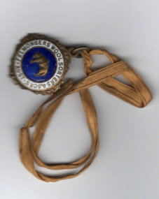
Medallion, Australian Felmongers Wool Sorters
... These included the Dallimore Fellmongery at Lake Gillear, the Bennett Merri Bank Fellmongery at Dennington and the fellmongery businesses of James Evenett and Henry Mawbey on the Merri River in South Warrnambool....Merri St) Warrnambool great-ocean-road This is a badge of an Australian association of fellmongers, wool sorters and scourers. This group may have been part of the Amalgamated Fellmongers, Wool Sorters and Wool Scourers Union of 1912-1918 or it may have been an earlier association. A fellmonger was a dealer in the hides or skins of animals, especially sheep, or a person who removed the skins from animals. There were several fellmongery and wool scouring establishments in 19th century Warrnambool and district. These included the Dallimore Fellmongery at Lake Gillear, the Bennett Merri Bank Fellmongery at Dennington and the fellmongery businesses of James Evenett and Henry Mawbey on the Merri ...This is a badge of an Australian association of fellmongers, wool sorters and scourers. This group may have been part of the Amalgamated Fellmongers, Wool Sorters and Wool Scourers Union of 1912-1918 or it may have been an earlier association. A fellmonger was a dealer in the hides or skins of animals, especially sheep, or a person who removed the skins from animals. There were several fellmongery and wool scouring establishments in 19th century Warrnambool and district. These included the Dallimore Fellmongery at Lake Gillear, the Bennett Merri Bank Fellmongery at Dennington and the fellmongery businesses of James Evenett and Henry Mawbey on the Merri River in South Warrnambool.Although it has no known local provenance, this badge is of interest because there were several fellmongery establishments in the Warrnambool district in the 19th century so it may have belonged to a local person.This medallion has a gold coloured image of a suspended lamb on a circular royal blue enamel background which in turn is surrounded by a white enamel annulus with text. The external brass edging is filigree. The medallion has an attached ring at the top with narrow gold ribbon threaded through an additional ring FELLMONGERS WOOL SORTERS & SCRS' . AUST. WOOLANDSKIN 82? G.P.O.PLACE W fellmongers, warrnambool history, dallimore fellmongery, bennett merri bank fellmongery, james evenett, henry mawbey -
 Warrnambool and District Historical Society Inc.
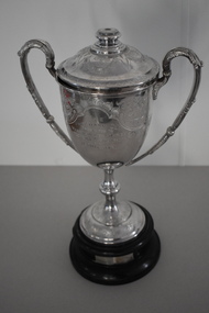
Trophy, Walker & Hall Ltd Silversmiths, Pritchard cup, 1920s
... Merri St) Warrnambool great-ocean-road This is a trophy given to a Warrnambool Football Association by Harry Pritchard. He was a Warrnambool businessman who had the Warrnambool Sports Depot store in Kepler Street in the 1920s. The trophy was for the winner of the Warrnambool Wards Football Association. This was a Junior Association promoted by the Warrnambool Football Club and it existed from 1924 to 1930. It was proposed that the four Council Wards, Hopkins, Victoria, Albert and Merri ...This is a trophy given to a Warrnambool Football Association by Harry Pritchard. He was a Warrnambool businessman who had the Warrnambool Sports Depot store in Kepler Street in the 1920s. The trophy was for the winner of the Warrnambool Wards Football Association. This was a Junior Association promoted by the Warrnambool Football Club and it existed from 1924 to 1930. It was proposed that the four Council Wards, Hopkins, Victoria, Albert and Merri each had a football team but it is not clear if all had teams and how many teams from other areas took part in the competition. The Pritchard Cup records that the Hopkins Ward Football Team won the trophy in 1926 and that Allansford, a team outside of the four wards, won in 1927. The records of the Allansford Football Club go back to the 1890s. This cup is of considerable interest, firstly as an attractive trophy in its own right and secondly as a memento of a football association connected with the Warrnambool Council Wards. Both the Council Wards structure and the Wards football association no longer exist. This is a silver cup with two ornamental handles, a slender stem and a silver base. The cup has a lid with a knob in the middle. The cup, lid and base are all heavily etched and patterned with scrolls, leaves and flowers. There is an inscription on one side of the cup. The cup sits on a circular brown wooden base which has a cloth or paste mixture affixed to the bottom. The wooden section has two silver plaques with inscriptions. There is a small piece of wood missing on the side of the top of the mount. ‘The Pritchard Cup presented to Warrnambool Ward’s (sic) Football Association by H. Pritchard.’ ‘Won by Hopkins Ward Football Club Season 1926’ ‘Won by Allansford Football Club Season 1927’ football in warrnambool district, harry pritchard, warrnambool 1920s, history of warrnambool -
 Warrnambool and District Historical Society Inc.
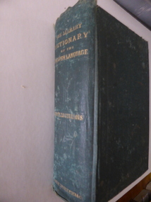
Book, The Library Dictionary of the English Language
... Merri St) Warrnambool great-ocean-road This dictionary belonged to John Brass, an early settler in South Warrnambool. He owned several blocks of land and operated a lighterage business with John Young. As a lighterman and boatman he was well-known in Warrnambool. He was drowned in March 1895 while attempting to cross a temporary foot bridge across the Merri ...This dictionary belonged to John Brass, an early settler in South Warrnambool. He owned several blocks of land and operated a lighterage business with John Young. As a lighterman and boatman he was well-known in Warrnambool. He was drowned in March 1895 while attempting to cross a temporary foot bridge across the Merri River. His house (probably in Stanley Street) was built in 1868 and remained as an interesting example of a lighterman’s cottage until1974. The dictionary probably became the property of W. Macdonald after John Brass’ death. No information has been found on this W. Macdonald. This book is of interest as it belonged to John Brass, an important early settler in South Warrnambool. This is a hard cover book of 974 pages. The cover is green with embossed patterning and lettering on the front cover and gold lettering on the spine. The book has a Preface, a Contents page, the Dictionary entries and an Appendix. There are many illustrations, from engravings on wood, scattered throughout the text. The cloth binding is coming loose and there are several loose pages. The last page is missing. The inscriptions are written in pencil and in blue ink and there are red stamps of John Brass. The cover is stained and faded. ‘John Brass, South Warrnambool, Victoria, Aust- 1893’ ‘June 5 x 6 x 93’ ‘J.Brass, Jetty’ Stamps – ‘John Brass, South Warrnambool’ ‘W.J. Macdonald, Moyston, Dec.23-11-95’ ‘W.J.McDonald’ john brass, history of south warrnambool, w. macdonald (moyston), warrnambool’s maritime history -
 Warrnambool and District Historical Society Inc.
Book, John Ross notebook, 1890s
... Warrnambool and District Historical Society Inc. 2 Gilles Street (south of Merri St) Warrnambool great-ocean-road This small note book belonged to John Ross, the Warrnambool Town Surveyor and Engineer (1889-1906 & 1913-1914). The book lists the levels taken for the benefit of contractors undertaking jobs for the Warrnambool Council from 1898 to 1902. The jobs include ‘Russells Creek from the Merri ...This small note book belonged to John Ross, the Warrnambool Town Surveyor and Engineer (1889-1906 & 1913-1914). The book lists the levels taken for the benefit of contractors undertaking jobs for the Warrnambool Council from 1898 to 1902. The jobs include ‘Russells Creek from the Merri River upwards’, ‘Outlet at the Flume’, ‘Guns at the Battery’ and Drainage from the Terminus Hotel to the end of the Japan Street Tunnel’. John Ross was also in private practice with the architectural firm of Ross and Jackman. This notebook is of considerable interest because it is an original note book that belonged to John Ross, the Warrnambool Town Surveyor and Engineer in the late 19th century and early 20th century. The note book contains important information on the engineering projects in Warrnambool and district from 1898 to 1902. This note book has a red leather cover. The cover is a little creased. The inside pages have ruled red lines and printed headings regarding the levels taken of a site and the location of the site (1898 to 1902). The engineer’s entries in the printed columns are handwritten , mostly in pencil. The inscription on the first page is handwritten in black ink. ‘Jno C Ross, Town Surveyor Wbool 19/5/98’ john ross, warrnambool town council, history of warrnambool -
 Warrnambool and District Historical Society Inc.
Document - Ledger, Standard Articles, Mid 20th century
... Warrnambool and District Historical Society Inc. 2 Gilles Street (south of Merri St) Warrnambool great-ocean-road This ledger contains original Warrnambool Standard newspaper cuttings of the eleven articles written by Henri Worland on the early history of Warrnambool. The subject matter includes the Post and Telegraph Office, Punts over the Merri ...This ledger contains original Warrnambool Standard newspaper cuttings of the eleven articles written by Henri Worland on the early history of Warrnambool. The subject matter includes the Post and Telegraph Office, Punts over the Merri and Hopkins Rivers, Transport in the Early Days, Early Exploration, Minjah Station and the History of the Breakwater. Henri Worland (1883-1972) was Warrnambool’s most important 20th century local historian. He was the Town Clerk of Warrnambool from 1918 to 1949 and his intense interest in Warrnambool’s history led him to collect and preserve a great amount of local history material. He wrote extensively on Warrnambool’s history and gave talks on the local radio station over a period of many years.These newspaper cuttings are of interest as examples of the many local history articles written by the important Warrnambool historian Henri Worland. The Warrnambool and District Historical Society has a collection of Worland’s original writings in his own handwriting. This is a ledger book with a brown-coloured cover with red binding. There is a label pasted on to the front cover with black printing on it. The ledger has indented alphabet tabs and the pages are ruled with red lines for ledger purposes but these have not been used. The ledger has been used to paste in original cuttings from the Warrnambool Standard newspaper (Henri Worland articles from the 1940s). One page contains two copies of old photographs. Some of the pages have been reinforced with staples and some pages have become detached from the binding. ‘Ledger’ henri worland, history of warrnambool -
 Warrnambool and District Historical Society Inc.
Documents, Swintons Paper att 18/53 Merri St. Contract. Map. Notes, 1959
... Merri St) Warrnambool great-ocean-road These documents relate to the sale of land in Merri Street Warrnambool in 1959 by Swintons Pty Ltd of Warrnambool. The buyer of the land was George O’Grady, a Warrnambool baker. The land sold for £4000 and there was a shed on the land (called the ‘Office’) which George O’Grady indicated he wished to be included in the sale. William and Ann Swinton migrated to Australia in 1854 and for a decade William Swinton worked as a builder and carpenter in the Warrnambool area, erecting many buildings, including the Wangoom Presbyterian Church. In 1865 he opened a store in Timor Street Warrnambool, selling groceries, hardware, china and glassware. By 1888 the business was known as William Swinton and Sons. Branch stores were opened in Wangoom, Cudgee, Nullawarre, South Warrnambool and West Warrnambool. After William Swinton died his son Robert became the first managing director of Swintons Pty Ltd. In 1934 the business split with George Swinton and Sons selling clothing, furnishings and glassware and Swintons Pty Ltd selling seeds, produce and hardware. Today the Swinton family still operates a furniture and bedding shop in Timor St Warrnambool. These items are of some interest as being connected to the Warrnambool business of Swintons Pty Ltd. They will be of interest to researchers. The current Swinton business in Timor Street is the oldest family business in Warrnambool and, with the name Swinton associated with businesses in Timor Street Warrnambool for 152 years it is amongst the oldest family businesses in Australia. swinton family, warrnambool .2 ‘Plan of Survey of Part of Crown Allotment 18 Section 3 Township of .2 ‘Plan of Survey of Part of Crown Allotment 18 Section 3 Township of Warrnambool Parish of Wangoom County of Villiers’ .3 ‘Tuesday Dear Mr Swinton I am writing to say that I would like to have the ‘Office’ Thanking You George O’Grady’ The items here relate to the sale of land by Swintons Pty Ltd., Warrnambool. .1 These are three pages of white paper with typed material, a lawyer’s signature in blue ink, one green stamp and a sketch of the land location. .2 This is a sheet of thick paper containing a plan of the land sold. The paper has printed material and a sketch of the land with part of it coloured in pink. .3 This is a small piece of paper torn at the bottom right edge. It has handwritten material (a letter) in blue ink. Swintons Paper att 18/53 Merri ...These documents relate to the sale of land in Merri Street Warrnambool in 1959 by Swintons Pty Ltd of Warrnambool. The buyer of the land was George O’Grady, a Warrnambool baker. The land sold for £4000 and there was a shed on the land (called the ‘Office’) which George O’Grady indicated he wished to be included in the sale. William and Ann Swinton migrated to Australia in 1854 and for a decade William Swinton worked as a builder and carpenter in the Warrnambool area, erecting many buildings, including the Wangoom Presbyterian Church. In 1865 he opened a store in Timor Street Warrnambool, selling groceries, hardware, china and glassware. By 1888 the business was known as William Swinton and Sons. Branch stores were opened in Wangoom, Cudgee, Nullawarre, South Warrnambool and West Warrnambool. After William Swinton died his son Robert became the first managing director of Swintons Pty Ltd. In 1934 the business split with George Swinton and Sons selling clothing, furnishings and glassware and Swintons Pty Ltd selling seeds, produce and hardware. Today the Swinton family still operates a furniture and bedding shop in Timor St Warrnambool.These items are of some interest as being connected to the Warrnambool business of Swintons Pty Ltd. They will be of interest to researchers. The current Swinton business in Timor Street is the oldest family business in Warrnambool and, with the name Swinton associated with businesses in Timor Street Warrnambool for 152 years it is amongst the oldest family businesses in Australia.The items here relate to the sale of land by Swintons Pty Ltd., Warrnambool. .1 These are three pages of white paper with typed material, a lawyer’s signature in blue ink, one green stamp and a sketch of the land location. .2 This is a sheet of thick paper containing a plan of the land sold. The paper has printed material and a sketch of the land with part of it coloured in pink. .3 This is a small piece of paper torn at the bottom right edge. It has handwritten material (a letter) in blue ink..2 ‘Plan of Survey of Part of Crown Allotment 18 Section 3 Township of .2 ‘Plan of Survey of Part of Crown Allotment 18 Section 3 Township of Warrnambool Parish of Wangoom County of Villiers’ .3 ‘Tuesday Dear Mr Swinton I am writing to say that I would like to have the ‘Office’ Thanking You George O’Grady’swinton family,, warrnambool -
Warrnambool and District Historical Society Inc.
Document, Wollaston sale, 1919
... Merri St) Warrnambool great-ocean-road This is a poster advertising the sale of part of the Wollaston Estate in Warrnambool in 1919. The sections for sale were Allotments 1, 18 and 19 which included the Wollaston Homestead. The original Wollaston property of 679 acres was selected by Thomas Manifold in the late 1840s. This land, on the northern side of the Merri ...This is a poster advertising the sale of part of the Wollaston Estate in Warrnambool in 1919. The sections for sale were Allotments 1, 18 and 19 which included the Wollaston Homestead. The original Wollaston property of 679 acres was selected by Thomas Manifold in the late 1840s. This land, on the northern side of the Merri River, near the Woodford Road was three kilometres from the Warrnambool town. The first farmer we know who leased the property was William Simpson. Walter Manifold inherited the property and he took it over in 1884. The swing bridge he built in 1890 still stands today. In 1919 the Closer Settlement Board of Victoria acquired Wollaston and 17 lots were sold to returned soldiers for farming purposes. By 1930 there were only five soldier settlers remaining. In 2009 further subdivision took place with lots sold for residential purposes. The homestead allotments were sold separately in 1919 with various owners of the homestead itself recorded since that time. This poster is of interest as it shows the areas of the Wollaston Estate which were sold in 1919. The history of this estate is well-documented and of importance in the history of Warrnambool. This is a sheet of paper with red and black printing and a map of the Wollaston Estate which is photo-lithographed. The sheet has been folded three times. It has some small tears at the top of the page. wollaston, history of warrnambool, walter manifold -
 Warrnambool and District Historical Society Inc.
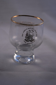
Household, Jellie Souvenir Glass
... Warrnambool and District Historical Society Inc. 2 Gilles Street (south of Merri St) Warrnambool great-ocean-road souvenir glass was produced to commemorate the 1841 arrival in Australia from Ireland of James and Margaret Jellie . They were early settlers in the Warrnambool district, settling first at Port Fairy and then acquiring property along the Merri River in the Warrnambool area. ...souvenir glass was produced to commemorate the 1841 arrival in Australia from Ireland of James and Margaret Jellie . They were early settlers in the Warrnambool district, settling first at Port Fairy and then acquiring property along the Merri River in the Warrnambool area. Their children and families were prominent in the 19th and 20th centuries in the Warrnambool district as pastoralists, particularly in the Grasmere area. One son, James had an auctioneering firm in Warrnambool in the late 19th century and two of James’ and Margaret’s granddaughters, Mary and Dorcas. were well-known as teachers at the Warrnambool State School in the 20th century. This glass is of interest as a memento of the Jellie families who have been so prominent in the history of Warrnambool and district.This is a glass tumbler with a rounded base and a rounded body with a gilt rim around the top of the glass. An image of a ship and gold lettering have been impressed on both sides of the glass. ‘James & Margaret Jellie 1841-1991 150th Anniversary’ ‘To commemorate the arrival of James & Margaret Jellie and their children on the Thomas Arbuthnot at Hobson’s Bay, Port Phillip District of New South Wales on 2 October 1841 and their journey to Port Fairy in early 1842’ jellie families, warrnambool, history of warrnambool