Showing 237 items matching "murray's bridge"
-
 Eltham District Historical Society Inc
Photograph, Tess Justine (Nillumbik Shire Council), Murray's Bridge over the Diamond Creek, Eltham North, 19 Feb 2022
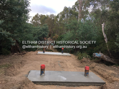
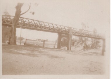
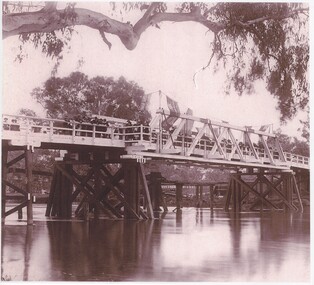
... Murray's Bridge over the Diamond Creek, Eltham North...bridge...‘Laurel Hill’...John Wright Murray...Murray's Bridge over the Diamond Creek on the Diamond Creek Trail just prior to demolition and replacement with a new steel bridge. ...Lessons were learnt, and Murrays Bridge appears to have been built in accordance with Country Road Board standards of the time. ...Murray's Bridge over the Diamond Creek on the Diamond Creek Trail just prior to demolition and replacement with a new steel bridge. Heritage advice obtained by Nillumbik Shire Council, following a suggestion by the Eltham District Historical Society (EDHS), is that the original bridge appears to have been a simplified version of the Country Roads Board’s (CRB) standard timber bridge design of the early-to-mid 1920s. In c1990 Murray’s bridge was renovated with three recycled steel girders as part of a bike/pedestrian path in the reserve. During these alterations many parts of the bridge were removed, and some were replaced. Heritage advice indicates the condition of Murray’s bridge is poor. The remaining original parts are all in poor condition, with severe weathering, splitting and rot, especially to the stringers retained on the bridge. Heritage advice is that Murray’s Bridge does not have sufficient significance in the cultural history of the Nillumbik area to warrant inclusion in the Nillumbik Shire Heritage Overlay and also does not have sufficient significance as a rare survivor to warrant inclusion in the Nillumbik Shire Heritage Overlay. There are no indications in the historical record that this site was individually important to the cultural history of this area. EDHS is comfortable with the heritage advice provided to Council and has worked closely on this project with Council. EDHS has suggested some of the removed timbers be used in the vicinity of the bridge for landscaping and possibly seating, so as to retain these remnants close to the site of the original bridge, which is the last old timber bridge along the lower reaches of the Diamond Creek. Mary (Sweeney) Murray and John Wright Murray selected 80 acres, Lot C Section 16 and Lot 5 Section 17 Parish of Nillumbik, under an occupation license in 1866. John died in 1867 and freehold was granted to his son John in 1873. The farm was known as ‘Laurel Hill’. John Junior was an Eltham Shire councillor and sometime president from 1887 up until 1897. He added Lot A Section 16 to the farm in ca1888. John and his younger brother James arranged to rent/purchase Lot B Section 17, across Diamond Creek to the west, in ca1900. It appears that John and James farmed separately for a few years, with a new homestead built for James ad family on the high point of Lot B Section 17 in ca1910. John sold off Lot 5 Section 17 in 1912. When John died in 1912 James took over the land on both sides of the Diamond Creek. The old homestead on the west side of the Creek disappeared. A farm bridge over Diamond Creek from this period may have been located close to the northern boundary of the farm. John Langlands, owner of the farm known as ‘Ihurst’ on the west side of Diamond Creek to the south of the Murray’s land, died in 1907. In 1909 his land was then subdivided into 100 lots to become the ‘Glen Park Estate’. Other similar subdivisions of nineteenth century farms around Eltham in this period included the ‘Franktonia (or Beard’s) Estate’ to the northeast and ‘Bonsack’s Estate’ between Eltham and Greensborough. Soon after the opening of the railway extension line from Eltham to Hurstbridge in 1912, Glen Park and nearby residents including James Murray agitated for a railway station or siding to be located half-way between Eltham and Hurstbridge, so that the Glen Park residents who used the railway daily did not have to walk into the Eltham or Hurstbridge stations. Some believed Coleman’s Corner (opposite Edendale Farm) was an appropriate spot for the platform. James Murray was among those who thought the railway should be located on his land, closer to half-way between Eltham and Hurstbridge stations. The Railways Commissioners warned that the locals would have to fund these works themselves. The Glen Park Estate residents initially had difficulty accessing Eltham by road, with only an old low-level bridge over Diamond Creek at the south end of their estate. A new timber trestle bridge across the creek, now on Wattletree Road, was opened in 1915. Road access to the north was gained in 1927 when the new Murray’s Road, which crossed the Murray’s land, was built. Residents continued to agitate for a Glen Park station. By 1926 the Railways Commissioners’ preferred site was on the Murray’s land. They arranged an estimate of cost of a full-length platform. The estimate was too much for the locals, who in 1928 argued unsuccessfully for a shorter and hence cheaper platform. By 1929 Murray had agreed to donate the land, but the locals would still have to fund the works. Murray decided, unilaterally it would appear, to commence work on a timber trestle road bridge over Diamond Creek to link the new Murray Road to the proposed station. Late in 1929 he stopped work on the bridge, for reasons unknown, but started work again and completed the bridge in 1931. There is no further newspaper evidence of the campaign for the Glen Park station until 1939, when Murray and another local, Mr Maxwell, met the Railways Commissioner. The Glen Park locale now included 45 homes on the west side of the creek and 20 on the Eltham side. Most of the residents used the train every day. The Commissioner remained adamant that only a full-length platform could be built for safety reasons. It appears the campaign dissolved at this point. The increasing move to cars may have had an impact. There is no evidence of Murray’s bridge ever being connected to Murray’s Road, or of it having wide use for any purpose by locals. James Murray died in 1947 and the farm was taken over by his son James (Jim). Jim started to sell off parts of the farm in the 1980s, retaining a few acres around the ca1910 homestead and building a new house there. Recreation reserves were established along the creek. In ca1990 Murray’s bridge was renovated with steel girders as part of a bike/pedestrian path in the reserve. The old farmhouse was demolished in ca2014. * * * A theory posted on local community Facebook groups was that the bridge was built in the 1860s and was built to be more robust than was necessary for the movement of cows from one side of the creek to the other. It was suggested the robustness was necessary to support the weight of gold ore being transferred from a mine on Murray’s land to a railway siding near Murrays Bridge (presumably for transfer and processing at Diamond Creek). Perhaps this may have been one of the motivators for Murray, who really knows? Knowing when mining operations ceased on his land and how that fits the overall timeline would be useful but at the time the bridge was built, local gold production was minimal at best. The known facts are: • The railway line came to Eltham in 1902. • The extension of the railway from Eltham to Hurstbridge was constructed in 1912 so no railway line even existed through Murray's property until 1912 and the Victorian Railways maps at the time show no such siding on Murray’s property. • In 1923 a new company was formed in anticipation of the old Diamond Creek Gold Mine being re-opened. The mine had been previously closed and flooded. It was noted in the press at the time that the mine was within a mile of the railway. Nothing really came of this. • Construction of Murrays Bridge was commenced by James Murray in early 1929 in anticipation of a proposed flag station being nominated on his land, but work ceased shortly afterwards. The proposed flag station was commonly referred to as Glen Park as the residents of the Glen Park Estate wanted Option 1, located near them with the platform adjacent to Colemans corner. This was probably never going to fly as it was virtually in eyesight of Eltham station. Allandale Road was the third option, but the Commissioners' preferred option was No. 2 - on Murray's property. • The Railway Commissioners were not going to finance any such station and the works had to be funded by private landowners and residents, hence Murray investing in this himself. • Murray recommenced work two years later and finished his bridge in 1931 but unfortunately for him, the proposed flag station never eventuated. The bluestone siding you reference may well have been built by Murray as part of the proposed station platform. • Up until then, apart from the Main Road bridge, which was washed away in 1924, virtually all local crossings over the Diamond Creek were low lying bridges – Kaylocks Bridge at Brougham Street, Diamond Street bridge, Glen Park Road bridge. It is expected that Murray also had a low-lying bridge to connect his land either side of the creek. These were all washed away or severely damaged multiple times in the 1920s. Lessons were learnt, and Murrays Bridge appears to have been built in accordance with Country Road Board standards of the time. Flood damage was ongoing, and even more recently constructed raised bridges kept getting washed away, e.g., the new Wattle Tree Road bridge in 1958 just months after completion. Murray’s bridge was reinforced with steel some 30 years ago presumably to provide additional floodwater resistance, given the history of bridges disappearing in floodwaters. • In March 1932 it was reported in the Advertiser that there were still some prospectors operating around Eltham North who apart from further scarring the face of the earth over the previous two years had gained significant experience but little gold - hardly a driving factor for constructing a dedicated railway siding and bridge to transfer gold ore. It is far more probable that James Murray was hoping to have the railway station located on his property and invested his money by building the bridge to lead to it as well as a station platform. Had the station eventuated, it may well have driven up the value of his land for subdivision and new housing estates like the Glen Park Estate. That did not eventuate. Whilst the bridge was indeed old (90 years), the core structure being completed in 1931, it had been modified substantially from original and hence had no significant historic value – i.e., it was not a representative example of its type, construction, and age. Given that the bridge was not worthy of saving, the Eltham District Historical Society with Council’s support, and the Eltham Woodworkers group endeavoured to see what suitable sized timbers were salvageable to fabricate a commemorative seat. Unfortunately, the experts at the Woodworkers group were unable to salvage any suitable length/width timbers to fabricate the seat due to the presence of rot. Last remaining wooden trestle bridge on the Diamond Creek Trail just prior to demolition and replacementBorn digital image (27)diamond creek (creek), diamond creek trail, murrays bridge, ‘laurel hill’, john wright murray, mary (sweeney) murra, john murray jnr, james murray, john langlands, ‘ihurst’, ‘glen park estate’, beard's estate, franktonia, bonsack's estate, glen park estate, glen park railway station -
 Eltham District Historical Society Inc
Photograph, Tess Justine (Nillumbik Shire Council), Construction work on replacement of Murray's Bridge over the Diamond Creek, Eltham North, 31 Mar 2022
... Construction work on replacement of Murray's Bridge over the Diamond Creek, Eltham North...bridge...‘Laurel Hill’...John Wright Murray...There is no evidence of Murray’s bridge ever being connected to Murray’s Road, or of it having wide use for any purpose by locals. ...There is no evidence of Murray’s bridge ever being connected to Murray’s Road, or of it having wide use for any purpose by locals. ...Construction work on replacement of Murray's Bridge over the Diamond Creek on the Diamond Creek Trail Mary (Sweeney) Murray and John Wright Murray selected 80 acres, Lot C Section 16 and Lot 5 Section 17 Parish of Nillumbik, under an occupation license in 1866. John died in 1867 and freehold was granted to his son John in 1873. The farm was known as ‘Laurel Hill’. John Junior was an Eltham Shire councillor and sometime president from 1887 up until 1897. He added Lot A Section 16 to the farm in ca1888. John and his younger brother James arranged to rent/purchase Lot B Section 17, across Diamond Creek to the west, in ca1900. It appears that John and James farmed separately for a few years, with a new homestead built for James ad family on the high point of Lot B Section 17 in ca1910. John sold off Lot 5 Section 17 in 1912. When John died in 1912 James took over the land on both sides of the Diamond Creek. The old homestead on the west side of the Creek disappeared. A farm bridge over Diamond Creek from this period may have been located close to the northern boundary of the farm. John Langlands, owner of the farm known as ‘Ihurst’ on the west side of Diamond Creek to the south of the Murray’s land, died in 1907. In 1909 his land was then subdivided into 100 lots to become the ‘Glen Park Estate’. Other similar subdivisions of nineteenth century farms around Eltham in this period included the ‘Franktonia (or Beard’s) Estate’ to the northeast and ‘Bonsack’s Estate’ between Eltham and Greensborough. Soon after the opening of the railway extension line from Eltham to Hurstbridge in 1912, Glen Park and nearby residents including James Murray agitated for a railway station or siding to be located half-way between Eltham and Hurstbridge, so that the Glen Park residents who used the railway daily did not have to walk into the Eltham or Hurstbridge stations. Some believed Coleman’s Corner (opposite Edendale Farm) was an appropriate spot for the platform. James Murray was among those who thought the railway should be located on his land, closer to half-way between Eltham and Hurstbridge stations. The Railways Commissioners warned that the locals would have to fund these works themselves. The Glen Park Estate residents initially had difficulty accessing Eltham by road, with only an old low-level bridge over Diamond Creek at the south end of their estate. A new timber trestle bridge across the creek, now on Wattletree Road, was opened in 1915. Road access to the north was gained in 1927 when the new Murray’s Road, which crossed the Murray’s land, was built. Residents continued to agitate for a Glen Park station. By 1926 the Railways Commissioners’ preferred site was on the Murray’s land. They arranged an estimate of cost of a full-length platform. The estimate was too much for the locals, who in 1928 argued unsuccessfully for a shorter and hence cheaper platform. By 1929 Murray had agreed to donate the land, but the locals would still have to fund the works. Murray decided, unilaterally it would appear, to commence work on a timber trestle road bridge over Diamond Creek to link the new Murray Road to the proposed station. Late in 1929 he stopped work on the bridge, for reasons unknown, but started work again and completed the bridge in 1931. There is no further newspaper evidence of the campaign for the Glen Park station until 1939, when Murray and another local, Mr Maxwell, met the Railways Commissioner. The Glen Park locale now included 45 homes on the west side of the creek and 20 on the Eltham side. Most of the residents used the train every day. The Commissioner remained adamant that only a full-length platform could be built for safety reasons. It appears the campaign dissolved at this point. The increasing move to cars may have had an impact. There is no evidence of Murray’s bridge ever being connected to Murray’s Road, or of it having wide use for any purpose by locals. James Murray died in 1947 and the farm was taken over by his son James (Jim). Jim started to sell off parts of the farm in the 1980s, retaining a few acres around the ca1910 homestead and building a new house there. Recreation reserves were established along the creek. In ca1990 Murray’s bridge was renovated with steel girders as part of a bike/pedestrian path in the reserve. The old farmhouse was demolished in ca2014. Born digital image (5)diamond creek (creek), diamond creek trail, murrays bridge, ‘laurel hill’, john wright murray, mary (sweeney) murra, john murray jnr, james murray, john langlands, ‘ihurst’, ‘glen park estate’, beard's estate, franktonia, bonsack's estate, glen park estate, glen park railway station -
 Port of Echuca
Black and white photograph
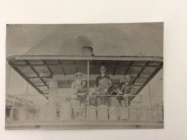
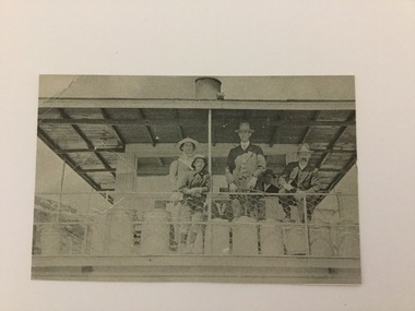
... Murray Bridge South Australia...On the back of the photograph is documented as being on the mail run and at the Murray Bridge....Documented as being on mail run and at the Murray Bridge (at Echuca)...Kelvin on mail run, Murray Bridge. Hugh Price at wheel in rear....Murray Bridge South Australia P.S. Kelvin mail run Hugh Price cargo Price Family Collection Kelvin on mail run, Murray Bridge. ...A copy of a black and white photograph of paddle steamer travel along the Murray river. It shows passengers (2 men, 1 girl, 1 boy) on the upper deck of the P. S. Kelvin, around the late 1890-1900. In the background is a third man, Hugh Price, at the wheel of the paddlesteamer. On the back of the photograph is documented as being on the mail run and at the Murray Bridge.Demonstrates passenger transport and travel along the river as well as the delivery of mail services between rural communities around the Murray Bridge, Blanchetown region in South Australia around 1890-1900.Copy of a Black and white photograph of 2 men, 1 girl and 1 boy on upper deck of P. S. Kelvin. In background is a 3rd man, Hugh Price, at the wheel. Documented as being on mail run and at the Murray Bridge (at Echuca)Kelvin on mail run, Murray Bridge. Hugh Price at wheel in rear.murray bridge south australia, p.s. kelvin, mail run, hugh price, cargo, price family collection -
 National Vietnam Veterans Museum (NVVM)
Plaque - Presented Plaque
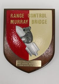
... Range Control Murray Bridge...Wooden plaque with cream, red, gold, silver and grey insignia of Range Control Murray Bridge, depicting a Koala riding a rocket. ...Range Control/ Murray Bridge/ WO2 Trevor Nicholson/ Range Control Murray Bridge/ from 22/1/87 to 12/1/90...Range Control Murray Bridge 4410261 WO2 Trevor Nicholson. Plaque Nicholson t nicholson shield Trevor Nicholson 4410261 Range Control/ Murray Bridge/ WO2 Trevor Nicholson/ Range Control Murray Bridge/ from 22/1/87 to 12/1/90 Wooden plaque with cream, red, gold, silver and grey insignia of Range Control Murray Bridge, depicting a Koala riding a rocket. ...Part of the estate of Sergeant Trevor J Nicholson, who served in Royal Australian Armoured Corps, C Squadron and B Squadron 1st Armoured Regiment, 1969-70, Vietnam.Wooden plaque with cream, red, gold, silver and grey insignia of Range Control Murray Bridge, depicting a Koala riding a rocket. Beneath that is an engraved metal edication.Range Control/ Murray Bridge/ WO2 Trevor Nicholson/ Range Control Murray Bridge/ from 22/1/87 to 12/1/90range control murray bridge, 4410261 wo2 trevor nicholson., plaque, nicholson, t nicholson, shield, trevor nicholson, 4410261 -
 Port of Echuca
Photograph, Original photo C.1910. Copy 1984
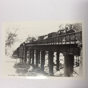
... ...Murray bridge, Echuca...Photograph of the Murray bridge at Echuca at low river with a goods train crossing the bridge. ...Recto :"MURRAY BRIDGE Echuca"; Verso: "C.1910" "Low river"...Dowell collection Murray river bridge , Echuca Murray bridge, Echuca Steam engine goods train Railway Transportation Industrialisation Recto :"MURRAY BRIDGE Echuca"; Verso: "C.1910" "Low river" Photograph of the Murray bridge at Echuca at low river with a goods train crossing the bridge. ...This photograph comes from the Dowell collection. Related to P000202. At the turn of the 20th century, the railway line carried produce from southern New South Wales and the Riverina to Melbourne. Goods trains were a very important mode to transport to our region and industrialisation of Echuca. Photograph of the Murray bridge at Echuca at low river with a goods train crossing the bridge. Image is seen from bank facing north from Echuca.Recto :"MURRAY BRIDGE Echuca"; Verso: "C.1910" "Low river"dowell collection, murray river bridge , echuca, murray bridge, echuca, steam engine goods train, railway, transportation, industrialisation -
 Bendigo Military Museum
Photograph - 4th Field Survey Squadron Regimental Training, Murray Bridge Training Area, SA, 1988
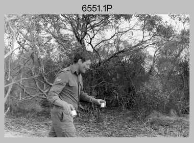
... 4th Field Survey Squadron Regimental Training, Murray Bridge Training Area, SA...4th Field Survey Squadron Regimental Training, Murray Bridge Training Area, SA...This is a set of eight photographs of 4th Field Survey Squadron personnel undergoing regimental training held at the Murray Bridge Training Area of South Australia in 1988. ...This is a set of eight photographs of 4th Field Survey Squadron personnel undergoing regimental training held at the Murray Bridge Training Area of South Australia in 1988. ....1P to .8P – There are no personnel identified. ‘1988 REGT ADV TRAINING MURRAY BRIDGE’ annotated on negatives sleeve.......Murray Bridge Training Area, South Australia...L to R: Unidentified, SGT Laurie Justin, remainder unidentified. 4th Field Survey Squadron Regimental Training, Murray Bridge Training Area, SA Photograph 4th Field Survey Squadron Regimental Training, Murray Bridge Training Area, SA Army Survey Regiment ...This is a set of eight photographs of 4th Field Survey Squadron personnel undergoing regimental training held at the Murray Bridge Training Area of South Australia in 1988. The aim of regimental training was typically to provide personnel a practical knowledge of infantry and minor tactics at the section level, navigation and map reading, RATEL and survival in the Field.This is a set of eight photographs of 4th Field Survey Squadron personnel undergoing regimental training held at the Murray Bridge Training Area of South Australia in 1988. The black and white photographs are on 35mm negative film and are part of the Army Survey Regiment’s Collection. The photographs were scanned at 96 dpi. .1) - Photo, black & white, 1988. CPL Steve McGuiness. .2) - Photo, black & white, 1988. L to R: Unidentified, SPR Charmian McKean. .3) - Photo, black & white, 1988. SPR Andrew Quin. .4) - Photo, black & white, 1988. L to R: Unidentified, LT Geoff ‘GT’ Ford. .5) & .6) - Photo, black & white, 1988. Unidentified personnel. .7) - Photo, black & white, 1988. L to R: Unidentified (x2), SPR Perry Langeberg, SGT Laurie Justin (3rd from right), remainder unidentified. .8) - Photo, black & white, 1988. L to R: Unidentified, SGT Laurie Justin, remainder unidentified..1P to .8P – There are no personnel identified. ‘1988 REGT ADV TRAINING MURRAY BRIDGE’ annotated on negatives sleeve.royal australian survey corps, rasvy, 4 fd svy sqn -
 Port of Echuca
A black and white photograph of a drawing, Black and white photograph of a drawing depicting the construction of the iron Murray Bridge, at Echuca, showing Surveyor, bridge workers, hoists, a crane, and much activity, 1981
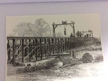
... Black and white photograph of a drawing depicting the construction of the iron Murray Bridge, at Echuca, showing Surveyor, bridge workers, hoists, a crane, and much activity....murray river...bridge...Photo is of a drawing of Bridge work taking place in 1877, across Murray River at Echuca. ...A black and white photograph of a drawing, depicting the construction of the iron Murray Bridge at Echuca, showing the Surveyor, the bridge workers, hoists , a crane, and much activity....Written in pen on the back, "Murray Bridge at Echuca under construction. Original to 'Age' came from Orm Cook. ...Written in pen on the back, "Murray Bridge at Echuca under construction. Original to 'Age' came from Orm Cook. ...Original negative and photograph held by The Age, before by Orm Cook, Echuca. Photo is of a drawing of Bridge work taking place in 1877, across Murray River at Echuca. Orm Cook gave The Age the photograph in 1981 as the round arches on the bridge were about to be removed.A bridge crossing of the Murray River was needed by 1877. It linked Echuca and Moama in a more tangible way. The bridge was funded privately and public use of it was discussed for the next several years.A black and white photograph of a drawing, depicting the construction of the iron Murray Bridge at Echuca, showing the Surveyor, the bridge workers, hoists , a crane, and much activity.Written in pen on the back, "Murray Bridge at Echuca under construction. Original to 'Age' came from Orm Cook. Also the numbers 6530 written in pen. Also on the back is a rectangular stamp with these words inside the rectangle. "COPYRIGHT. This photograph may not be reproduced without permission in writing from the Editor of "The Age" 250 Spencer Street, Melbourne, and 39/41 York St, Sydney.murray river, bridge work, bridge construction, bridge workers., the age newspaper., orm cook. -
 Port of Echuca
Black & white photograph
... ...murray bridge...Documented as being on mail run and at the Murray Bridge...Documented as being on mail run and at the Murray Bridge Echuca....Documented as being on mail run and at the Murray Bridge Echuca. Black & white photograph ...Black & white photograph of 2 men, 1 girl and 1 boy on upper deck of P. S. Kelvin. In the background is a 3rd man, Hugh Price, at the wheel. Documented as being on mail run and at the Murray BridgeDemonstrates passenger transport and travel along the river as well as the delivery of mail services between rural communities.Black & white photograph of 2 men, 1 girl and 1 boy on upper deck of P. S. Kelvin. In background is a 3rd man, (Hugh Price) at wheel. Documented as being on mail run and at the Murray Bridge Echuca.In pencil on back : Kelvinp.s. kelvin, murray bridge, mail run, paddlesteamers, murray river, hugh price -
 Whitehorse Historical Society Inc.
Book - Book 'The Home Workshop', 1948
... J.S.Edington - Murray Bridge....Whitehorse Historical Society Inc. 2-10 Deep Creek Road Mitcham melbourne books reference J.S.Edington - Murray Bridge. Blue cloth cover. faded blue spine (linen). ...Blue cloth cover. faded blue spine (linen). Paper 384 pages.J.S.Edington - Murray Bridge.books, reference -
 Eltham District Historical Society Inc
Document - Folder, Murray, John and Mary
... Murray...Julia Agnes Brennan...William Johnston...Isaac Rooks...John R Sabine...Murray's Bridge...John Wright Murray Mary Murray nee Sweeney Thomas Sweeney Diamond Creek Zig Zag Road Eltham Cemetery Johnnie Murray James Murray Eltham North Reserve Bridget Sweeney nee Coleman Bridget Cecilia Murray Michael (Mick) Dillon Hamilton Drain Mary Ellen Drain Thomas Drain John Murray Patrick Murray Thomas Murray William Murray Laurel Hill Farm Eltham Patrick Bernard Murray Elizabeth Josephine Tooher John Meyler Bagot Thomas Vincent Murray Margaret Gleeson William Louis Murray James Augustine Murray Julia Agnes Brennan William Johnston Isaac Rooks John R Sabine Murray's Bridge Wattletree Road Eltham Zig Zag Road Eltham Larry Brennan Evelyn Arms Hotel Eltham Newspaper clippings, A4 photocopies, etc Murray, John and Mary Document Folder ...John and Mary Murray settled in Eltham North in 1849 and his descendants lived in the area. Contents Letter: J N Murray to Eltham Historical Society, 16 August 1970. Requests information about the Murray family. Letter: J N Murray to B Wadeson [?Eltham Shire Council], 24 March 1974. Requests information about the Murray family. Letter: Brian R Smyth solicitor to Eltham Historical Society, 31 August 1993: Re estate of J E Murray and contents of buildings and site. Letter: Eltham Historical Society to Bryan Smyth, 7 September 1993: Re contents of buildings and site, in association of Shire of Diamond Valley. Newspaper article: "Back when the land was theirs", Diamond Valley News, 28 September 1992. Interview of James (Jim) Murray about his family and farm. Text: "A development philosophy for 'Murray's", Eltham North", by John R Sabine, September 1994 [history of family and Laurel Hill farm]. Photograph: Grave stone of John Murray, Mary Murray, Thomas Drain and Mary Ellen Drain. Text: "Murray" by A Sheehan, no date. History of Murray family. Text: John Wright Murray", no author, no date: History of John Wright Murray. Newspaper clippings, A4 photocopies, etcjohn wright murray, mary murray nee sweeney, thomas sweeney, diamond creek, zig zag road, eltham cemetery, johnnie murray, james murray, eltham north reserve, bridget sweeney nee coleman, bridget cecilia murray, michael (mick) dillon, hamilton drain, mary ellen drain, thomas drain, john murray, patrick murray, thomas murray, william murray, laurel hill farm eltham, patrick bernard murray, elizabeth josephine tooher, john meyler bagot, thomas vincent murray, margaret gleeson, william louis murray, james augustine murray, julia agnes brennan, william johnston, isaac rooks, john r sabine, murray's bridge, wattletree road eltham, zig zag road eltham, larry brennan, evelyn arms hotel eltham -
Ballarat Heritage Services
Photograph, River Boats Below Murray Bridge, South Australia
... River Boats Below Murray Bridge, South Australia......murray bridge...River Boats on Murray Bridge, South Australia....Ballarat Heritage Services PO Box 2209 Bakery Hill Post Office goldfields river boats murray bridge south Australia River Boats on Murray Bridge, South Australia. ...River Boats on Murray Bridge, South Australia.river boats, murray bridge, south australia -
 Rutherglen Historical Society
Image
... murray bridge...Written on back of photo: "Murray Bridge, Corowa N.S.W."...Rutherglen Historical Society Murray Street Rutherglen high-country murray bridge bridges murray river corowa Written on back of photo: "Murray Bridge, Corowa N.S.W." ...Black and white photograph of a bridge.Written on back of photo: "Murray Bridge, Corowa N.S.W."murray bridge, bridges, murray river, corowa -
 Bendigo Historical Society Inc.
Document - GERMAN HERITAGE SOCIETY COLLECTION: BUILDINGS, MINES & PLACES
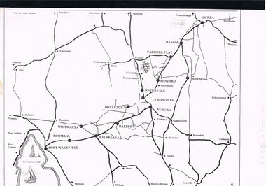
... ... Murray Bridge...Contains articles and photos about Tailem Bend, Murray Bridge, Kapunda, Burra, Clare, Penwortham, Sevenhill, Eudunda, Mintaro, Watervale, The House of Quelltaler, Leasingham and Auburn. ...Contains articles and photos about Tailem Bend, Murray Bridge, Kapunda, Burra, Clare, Penwortham, Sevenhill, Eudunda, Mintaro, Watervale, The House of Quelltaler, Leasingham and Auburn. ...Collection of Articles with a map of part of South Australia north of Adelaide. Contains articles and photos about Tailem Bend, Murray Bridge, Kapunda, Burra, Clare, Penwortham, Sevenhill, Eudunda, Mintaro, Watervale, The House of Quelltaler, Leasingham and Auburn. It also contains a story by Gaye Sprenglewski.societies, service clubs, german heritage society, german heritage society collection - colllection of articles about buildings, mines & places, tailem bend, murray bridge, kapunda, burra, clare, penwortham, sevenhill, eudunda, mintaro, watervale, the house of quelltaler, leasingham, auburn, gaye sprenglewski. -
Glenelg Shire Council Cultural Collection
Photograph - Photograph - Queen of the Murray Beauty Contest 1950, c. 1950
... Women in formal wear. 8 wearing sashes, including Miss Murray Bridge, Miss Yarrawonga, Miss Renmark, Miss Swan Hill, Miss ? ...Women in formal wear. 8 wearing sashes, including Miss Murray Bridge, Miss Yarrawonga, Miss Renmark, Miss Swan Hill, Miss ? ...Black and white photo. group of men and women. 'Queen of the Murray Beauty Contest 1950. Women in formal wear. 8 wearing sashes, including Miss Murray Bridge, Miss Yarrawonga, Miss Renmark, Miss Swan Hill, Miss ? Queen of the Murray 1950. Other men and women ? judges.Back: 'J Moore' - red biro. Stamp - very faint 'COPYRIGHT SUNRAYSIA DAILY' -
 Victorian Aboriginal Corporation for Languages
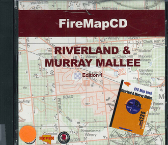
CD-ROM, Country Fire Services South Australia, FireMapCD Riverland &? Murray Mallee, 2001
... The area covered adjoins the Mount Lofty Ranges map book on the eastern boundary at Murray Bridge, north to Morgan and east to Renmark and the State Border. ...The area covered adjoins the Mount Lofty Ranges map book on the eastern boundary at Murray Bridge, north to Morgan and east to Renmark and the State Border. ...The area covered by this map is the same as the CFS Riverland & Murray Mallee Map Book. The area covered adjoins the Mount Lofty Ranges map book on the eastern boundary at Murray Bridge, north to Morgan and east to Renmark and the State Border. It extends southwards to join the northern boundary of the Lower South East map book at Padthaway.CD-ROMfire protection, victorian maps -
 Coburg Historical Society
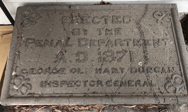
Artwork, other - Plaque (intended) for Murray Road Bridge, Bluestone Plaque intended for Murray Road Bridge, 1871
... Plaque (intended) for Murray Road Bridge ...Bluestone Plaque intended for Murray Road Bridge...The plaque was originally intended for the Murray Road Bridge. The Murray Road Bridge is of state historical and architectural significance. ...Coburg Historical Society Bluestone Cottage 82 Bell Street Coburg melbourne The plaque was originally intended for the Murray Road Bridge. The Murray Road Bridge is of state historical and architectural significance. ...The plaque was originally intended for the Murray Road Bridge. The Murray Road Bridge is of state historical and architectural significance. With the Newlands Street Bridge it is one of a pair of bluestone bridges constructed by prison labour in Coburg and is situated within the immediate vicinity of the Pentridge Prison. The bridge has one of five largest spans of stone bridges built in Australia, of which at least three survive. (VHR)BluestoneErected by the Penal Department A.D. 1871 George Oliphant Duncan Inspector General -
Surrey Hills Historical Society Collection
Work on paper - Photograph, Post-war wedding of Norman Pryde and Hilda Scales, 1935
... Norma died in 1997 in Murray Bridge, South Australia. John's full name was John Patrick Cleak (1923-2023). ...Norma died in 1997 in Murray Bridge, South Australia. John's full name was John Patrick Cleak (1923-2023). ...Information from the donor by email gives: Norma Pryde married John Cleak in Camberwell in 1947. Norma's parents were Norman & Hilda Pryde. Norma was born in 1924 in Surrey Hills and attended Surrey Hills State School. Information from the donor's Ancestry.com.au tree: Norma and John had 5 children: 4 boys and one girl. Norma died in 1997 in Murray Bridge, South Australia. John's full name was John Patrick Cleak (1923-2023). This photo documents a post-war wedding when quite often the bride, groom, and wedding party would all simply wear their best suits and dresses.A copy B&W wedding photo of 2 men and 2 women. The men are dressed in suits and wearing buttonholes. The women are wearing hats; the older woman has a corsage on the lapel of her coat and the younger woman is carrying a bouquet.NILnorma pryde, norma cleak, jenny pomeray, 1947, 1940-1949, norman pryde, hilda pryde, hilda gwendoline scales, hilda scales, john cleak, hilda gwendoline pryde, clothing and dress, weddings, john patrick cleak -
 Eltham District Historical Society Inc
Journal - Newsletter, Newsletter, No. 263 April 2022, Apr 2022
... Contents: • Proposed Demolition of the Eltham Courthouse by Jim Connor • Heritage Excursion – Along the Aqueduct – Saturday 7th May 2022 • Municipal District – Eltham (Victoria Gazette No. 140 – March 26, 1957 • Eltham Courthouse Officially Reopened by Jim Connor • Murray’s Bridge by Jim Connor • Shire of Eltham • A 21st Celebration? ...Eltham District Historical Society Inc 728 Main Rd Eltham melbourne Contents: • Proposed Demolition of the Eltham Courthouse by Jim Connor • Heritage Excursion – Along the Aqueduct – Saturday 7th May 2022 • Municipal District – Eltham (Victoria Gazette No. 140 – March 26, 1957 • Eltham Courthouse Officially Reopened by Jim Connor • Murray’s Bridge by Jim Connor • Shire of Eltham • A 21st Celebration? ...Contents: • Proposed Demolition of the Eltham Courthouse by Jim Connor • Heritage Excursion – Along the Aqueduct – Saturday 7th May 2022 • Municipal District – Eltham (Victoria Gazette No. 140 – March 26, 1957 • Eltham Courthouse Officially Reopened by Jim Connor • Murray’s Bridge by Jim Connor • Shire of Eltham • A 21st Celebration? By Jim Connor • Eltham Cemetery Stories by Liz Pidgeon o Elizabeth Agatha (Betty) Erickson, nee Carrucan 1915-1990 • Our History – Our Library • Annual General Meeting – 2.00pm, Saturday 23rd April 2022The Shire of Eltham Historical Society was formed in October 1967. The first newsletter of the Society was issued May 1978 and has been published continuously ever since on a bi-monthly basis. With the cessation of the Shire of Eltham in late 1994, the Society's name was revised to Eltham District Historical Society and this name first appeared with issue No. 103, July 1995. The collection of the Society's newsletters provides a valuable resource on the history of the Society's activities, office bearers and committee members, guest speakers and subjects of historical interest pertinent to the former Shire of Eltham and the Eltham District.A4 newsletter distributed to members (Digital and A4 photocopy)newsletter, eltham district historical society -
 Rutherglen Historical Society
Image, c1920
... murray river...howlong...bridge...Black and white photograph thought to have been taken at the opening of bridge over Murray River at Howlong...Rutherglen Historical Society Murray Street Rutherglen high-country murray river howlong bridge opening ceremonies Black and white photograph thought to have been taken at the opening of bridge over Murray River at Howlong Image ...Black and white photograph thought to have been taken at the opening of bridge over Murray River at Howlongmurray river, howlong, bridge, opening ceremonies -
 Wodonga & District Historical Society Inc
Functional object - Australian Army Issue Clasp Knife
... He also designed and built manufacturing equipment for General Motors Holden. He died at Murray Bridge (SA) in 1956....He also designed and built manufacturing equipment for General Motors Holden. He died at Murray Bridge (SA) in 1956. This item is significance because it was donated by a member of the community of Wodonga which has a strong connection to Australian military history. ...Australian manufactured clasp knives were a standard issue to Australian Military Forces during World War 2. The most commonly encountered knife was an all metal model with a canoe shaped body. This knife was a Whittingslowe first pattern clasp knife which included a blade, a tin opener and a marline spike as well as screw driver and shackle to attach the knife to a lanyard or belt clip. These knives were given a dull Nickel plating to protect them. William Thomas Whittingslowe was born in Wales in 1888, he was educated in England and at 18 migrated to Canada and then to Australia, arriving in about 1912. After working in various states, he settled in South Australia and in the 1920s set up his own business, Whittingslowe Engineers Limited. He specialised in ironworking and knife manufacturing. His firm produced a large amount of blade ware during World War 2. He also designed and built manufacturing equipment for General Motors Holden. He died at Murray Bridge (SA) in 1956.This item is significance because it was donated by a member of the community of Wodonga which has a strong connection to Australian military history.A clasp knife made completely from metal with nickel plating. The accessories all fold into a canoe-shaped body. It included a knife, can opener and marlin spike.On knife blade: WE over a broad arrow/I\australian army equipment ww2, thomas whittingslowe, australian army -
 Bendigo Historical Society Inc.
Postcard - Elliot Postcard Collection: Australia, 1895 - 1914
... James Elliot between 1898 and 1915. 1405.081 Yass River 1405.082 Botanic Gardens, Macquarie Street, Sydney 1405.083 The Scot's College, Rose Bay, N.S.W. 1405.084 Sydney Harbour Trust Offices, N.S.W. 1405.085 Suspension Bridge, North Sydney 1405.086 "Den Fenella" Wentworth Falls, N.S.W. 1405.087 Murray Bridge, from Cooma 1405.088 Road Scene, top of Berry Mountain, Shoalhaven District 1405.089 Manly from Red Hill 1405.090 Wynyard Square Park, Sydney 1405.091 Britannia Falls, Valley of Waters, Blue Mountains, N.S.W. 1405.092 Cronulla Beach near Sydney 1405.093 Weeping Rock, Wentworth 1405.094 Weir on a River 1405.095 The Blue Lake, near Mount Kosciusko, N.S.W. 1405.096 On Walla Walla Station 1405.097 Third Fall and Cascades, Moss Vale 1405.098 A Bush Stream 1405.099 The Curios, Jenolan, N.S.W. 1405.100 Rising Mists, Govetts Leap...James Elliot between 1898 and 1915. 1405.081 Yass River 1405.082 Botanic Gardens, Macquarie Street, Sydney 1405.083 The Scot's College, Rose Bay, N.S.W. 1405.084 Sydney Harbour Trust Offices, N.S.W. 1405.085 Suspension Bridge, North Sydney 1405.086 "Den Fenella" Wentworth Falls, N.S.W. 1405.087 Murray Bridge, from Cooma 1405.088 Road Scene, top of Berry Mountain, Shoalhaven District 1405.089 Manly from Red Hill 1405.090 Wynyard Square Park, Sydney 1405.091 Britannia Falls, Valley of Waters, Blue Mountains, N.S.W. 1405.092 Cronulla Beach near Sydney 1405.093 Weeping Rock, Wentworth 1405.094 Weir on a River 1405.095 The Blue Lake, near Mount Kosciusko, N.S.W. 1405.096 On Walla Walla Station 1405.097 Third Fall and Cascades, Moss Vale 1405.098 A Bush Stream 1405.099 The Curios, Jenolan, N.S.W. 1405.100 Rising Mists, Govetts Leap Postcard Elliot Postcard Collection: Australia ...Thought to have originated in Austria in 1869, postcards first gained popularity in Australia in the 1890s.They were used to send short messages to friends and family. This collection was generated by Mrs James Elliot of Talgarno. Talgarno is a rural locality in Victoria, Australia, situated on the southern shoreline of Lake Hume, about 23 km east of Albury-Wodonga. The collection contains postcards from across the world.Australian postcards collected by Mrs. James Elliot between 1898 and 1915. 1405.081 Yass River 1405.082 Botanic Gardens, Macquarie Street, Sydney 1405.083 The Scot's College, Rose Bay, N.S.W. 1405.084 Sydney Harbour Trust Offices, N.S.W. 1405.085 Suspension Bridge, North Sydney 1405.086 "Den Fenella" Wentworth Falls, N.S.W. 1405.087 Murray Bridge, from Cooma 1405.088 Road Scene, top of Berry Mountain, Shoalhaven District 1405.089 Manly from Red Hill 1405.090 Wynyard Square Park, Sydney 1405.091 Britannia Falls, Valley of Waters, Blue Mountains, N.S.W. 1405.092 Cronulla Beach near Sydney 1405.093 Weeping Rock, Wentworth 1405.094 Weir on a River 1405.095 The Blue Lake, near Mount Kosciusko, N.S.W. 1405.096 On Walla Walla Station 1405.097 Third Fall and Cascades, Moss Vale 1405.098 A Bush Stream 1405.099 The Curios, Jenolan, N.S.W. 1405.100 Rising Mists, Govetts Leappostcards, collecting, collections, talgarno -
![Scene Near the Buffalo Mountains / [by] Nicholas Caire, circa 1876](/media/collectors/550653872162f11fb04854aa/items/57826074d0cdd1176ce5bcc1/item-media/578260d1d0cdd1176ce5f61a/item-fit-380x285.jpg?cb=6) Kew Historical Society Inc
Kew Historical Society IncPhotograph, Anglo-Australasian Photographic Company, Scene Near the Buffalo Mountains, c. 1876
... The Buckland River is a small tributary of the Ovens River, which flows through the Beechworth district, and eventually finds its way to the River Murray. The Bridge which is seen on the right of the picture forms the roadway which leads from the Buckland Camp to the Township of Bright.’...The Buckland River is a small tributary of the Ovens River, which flows through the Beechworth district, and eventually finds its way to the River Murray. The Bridge which is seen on the right of the picture forms the roadway which leads from the Buckland Camp to the Township of Bright.’ ...Nicholas Caire was born on Guernsey in the Channel Islands in 1837. He arrived in Adelaide with his parents in about 1860. In 1867, following photographic journeys in Gippsland, he opened a studio in Adelaide. From 1870 to 1876 he lived and worked in Talbot in Central Victoria. In 1876 he purchased T. F. Chuck's studios in the Royal Arcade Melbourne. In 1885, following the introduction of dry plate photography, he began a series of landscape series, which were commercially successful. As a photographer, he travelled extensively through Victoria, photographing places few of his contemporaries had previously seen. He died in 1918. Reference: Jack Cato, 'Caire, Nicholas John (1837–1918)', Australian Dictionary of Biography.An original, rare photograph from the series 'Views of Victoria: General Series' by the photographer, Nicholas Caire (1837-1918). The series of 60 photographs that comprise the series was issued c. 1876 and reinforced a neo-Romantic view of the Australian landscape to which a growing nationalist movement would respond. Nicholas Caire was active as a photographer in Australia from 1858 until his death in 1918. His vision of the Australian bush and pioneer life had a counterpart in the works of Henry Lawson and other nationalist poets, authors and painters.‘Scene near the Buffalo Mountains’ : Views of Victoria (General Series) No.41 : Albumen silver photograph | Photo on card with Title and Description on reverse | Mounted 24 x 30 cm; Photo 12 x 17 cm.On Reverse: ‘This scene is taken from the banks of the Buckland River, which is about five miles distant from the Buffalo Mountains, as seen in the distance. These mountains are frequently covered with snow, in consequence of their great altitude. The Buckland River is a small tributary of the Ovens River, which flows through the Beechworth district, and eventually finds its way to the River Murray. The Bridge which is seen on the right of the picture forms the roadway which leads from the Buckland Camp to the Township of Bright.’nicholas caire (1837-1918), landscape photography -
 Charlton Golden Grains Museum Inc
Photograph, c.1960
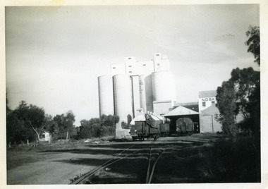
... Ltd., already owning mills in Horsham, Nhill, and Murray Bridge, acquired G. H. Foreman’s Mill located by the Avoca River. ...Ltd., already owning mills in Horsham, Nhill, and Murray Bridge, acquired G. H. Foreman’s Mill located by the Avoca River. ...Noske's mill in mid 1960s. Noske's Flour Mill, with its commanding presence and towering silos, has long **dominated the Charlton skyline** and remains a significant landmark, even though it no longer mills flour. The mill's history is deeply intertwined with the development of Charlton and the grain industry of the surrounding district. The foundation for the mill's presence was laid in 1919 when Messrs Noske Bros. Pty. Ltd., already owning mills in Horsham, Nhill, and Murray Bridge, acquired G. H. Foreman’s Mill located by the Avoca River. The founder, **T. J. Noske**, was an early pioneer of flour exporting, expanding his milling business after unexpectedly acquiring the Horsham mill. ### A State-of-the-Art Operation The original mill by the river operated until August 1926 before being closed and dismantled. Plans were well underway for a **new, state-of-the-art mill** to be located at the former Cobb and Co site. In 1927, the new mill began operation. It was one of the largest in the state, boasting a capacity of three tons of flour per hour, a 250 h.p. diesel engine, and three initial silos. The mill quickly gained a reputation for **excellence** for both its design and its flour, which was sold successfully in local and overseas markets. ### Periods of Expansion and Trial The mill continued to grow, reflecting the importance of the local agricultural industry. Between 1940 and 1941, **nine new silos** were built, adding bulk receival points. In the record-breaking 1968 season, the mill received a colossal wheat intake of **695,000 bushels**. However, the mill also faced setbacks. On January 21, 1949, disaster struck when a **large fire** erupted in the storage shed, which contained 500 tons of bagged flour ready for export and new flour bags. The blaze was so intense that smoke was visible as far away as Wycheproof, and it threatened to destroy the entire mill. Thanks to the monumental efforts of the Charlton, St. Arnaud, Wycheproof, and Wedderburn Brigades, who ran the main pump almost continuously for 26 hours, the damage was contained, though the estimated loss was a substantial £60,000. ### Transformation of the Site At its peak, the mill was a major employer, providing work for approximately 65–70 men. But after over 45 years of operation, flour production at the mill ceased on October 25, 1973. Noske Industries Ltd. sought to adapt, converting the operation to a less successful stock feed production centre. In 1977, the **Grain Elevators Board** took over the site as a grain receival depot, building a large elevator tower that surpassed the height of the original buildings. The site eventually returned to private hands and, since 2000, has been owned and operated as a primary grain receival site for **GrainCorp**, cementing its continued, vital role in Charlton's agricultural life.Black and white photograph with white border.charlton, business, noske's, flour mill -
 Charlton Golden Grains Museum Inc
Postcard, A view of Charlton. The seasons greeting from Charlton, c.1946
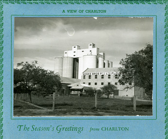
... Ltd., already owning mills in Horsham, Nhill, and Murray Bridge, acquired G. H. Foreman’s Mill located by the Avoca River. ...Ltd., already owning mills in Horsham, Nhill, and Murray Bridge, acquired G. H. Foreman’s Mill located by the Avoca River. ...Eight silos added in 1940s. Noske's Flour Mill, with its commanding presence and towering silos, has long **dominated the Charlton skyline** and remains a significant landmark, even though it no longer mills flour. The mill's history is deeply intertwined with the development of Charlton and the grain industry of the surrounding district. The foundation for the mill's presence was laid in 1919 when Messrs Noske Bros. Pty. Ltd., already owning mills in Horsham, Nhill, and Murray Bridge, acquired G. H. Foreman’s Mill located by the Avoca River. The founder, **T. J. Noske**, was an early pioneer of flour exporting, expanding his milling business after unexpectedly acquiring the Horsham mill. ### A State-of-the-Art Operation The original mill by the river operated until August 1926 before being closed and dismantled. Plans were well underway for a **new, state-of-the-art mill** to be located at the former Cobb and Co site. In 1927, the new mill began operation. It was one of the largest in the state, boasting a capacity of three tons of flour per hour, a 250 h.p. diesel engine, and three initial silos. The mill quickly gained a reputation for **excellence** for both its design and its flour, which was sold successfully in local and overseas markets. ### Periods of Expansion and Trial The mill continued to grow, reflecting the importance of the local agricultural industry. Between 1940 and 1941, **nine new silos** were built, adding bulk receival points. In the record-breaking 1968 season, the mill received a colossal wheat intake of **695,000 bushels**. However, the mill also faced setbacks. On January 21, 1949, disaster struck when a **large fire** erupted in the storage shed, which contained 500 tons of bagged flour ready for export and new flour bags. The blaze was so intense that smoke was visible as far away as Wycheproof, and it threatened to destroy the entire mill. Thanks to the monumental efforts of the Charlton, St. Arnaud, Wycheproof, and Wedderburn Brigades, who ran the main pump almost continuously for 26 hours, the damage was contained, though the estimated loss was a substantial £60,000. ### Transformation of the Site At its peak, the mill was a major employer, providing work for approximately 65–70 men. But after over 45 years of operation, flour production at the mill ceased on October 25, 1973. Noske Industries Ltd. sought to adapt, converting the operation to a less successful stock feed production centre. In 1977, the **Grain Elevators Board** took over the site as a grain receival depot, building a large elevator tower that surpassed the height of the original buildings. The site eventually returned to private hands and, since 2000, has been owned and operated as a primary grain receival site for **GrainCorp**, cementing its continued, vital role in Charlton's agricultural life.Large landscape black and white photo set on a blue card backing. The card has a green holly leaf pattern embossed on the edge.A view of Charlton. The Season's Greetings from Charlton.charlton, noske bros, noske's, flour mill -
 Charlton Golden Grains Museum Inc
Photograph, Charlton Shire, Charlton Flour Mill, c.1987
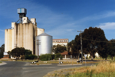
... Ltd., already owning mills in Horsham, Nhill, and Murray Bridge, acquired G. H. Foreman’s Mill located by the Avoca River. ...Ltd., already owning mills in Horsham, Nhill, and Murray Bridge, acquired G. H. Foreman’s Mill located by the Avoca River. ...A previous mill had operated in Charlton by Mr. W.E. Foreman on the banks of the Avoca River and was acquired in 1919 by Noske Bros. The present Flour Mill was built by Noske Bros and opened in May 1927. It was taken over by the Grain Elevator Board in the 1970s. Noske's Flour Mill, with its commanding presence and towering silos, has long **dominated the Charlton skyline** and remains a significant landmark, even though it no longer mills flour. The mill's history is deeply intertwined with the development of Charlton and the grain industry of the surrounding district. The foundation for the mill's presence was laid in 1919 when Messrs Noske Bros. Pty. Ltd., already owning mills in Horsham, Nhill, and Murray Bridge, acquired G. H. Foreman’s Mill located by the Avoca River. The founder, **T. J. Noske**, was an early pioneer of flour exporting, expanding his milling business after unexpectedly acquiring the Horsham mill. ### A State-of-the-Art Operation The original mill by the river operated until August 1926 before being closed and dismantled. Plans were well underway for a **new, state-of-the-art mill** to be located at the former Cobb and Co site. In 1927, the new mill began operation. It was one of the largest in the state, boasting a capacity of three tons of flour per hour, a 250 h.p. diesel engine, and three initial silos. The mill quickly gained a reputation for **excellence** for both its design and its flour, which was sold successfully in local and overseas markets. ### Periods of Expansion and Trial The mill continued to grow, reflecting the importance of the local agricultural industry. Between 1940 and 1941, **nine new silos** were built, adding bulk receival points. In the record-breaking 1968 season, the mill received a colossal wheat intake of **695,000 bushels**. However, the mill also faced setbacks. On January 21, 1949, disaster struck when a **large fire** erupted in the storage shed, which contained 500 tons of bagged flour ready for export and new flour bags. The blaze was so intense that smoke was visible as far away as Wycheproof, and it threatened to destroy the entire mill. Thanks to the monumental efforts of the Charlton, St. Arnaud, Wycheproof, and Wedderburn Brigades, who ran the main pump almost continuously for 26 hours, the damage was contained, though the estimated loss was a substantial £60,000. ### Transformation of the Site At its peak, the mill was a major employer, providing work for approximately 65–70 men. But after over 45 years of operation, flour production at the mill ceased on October 25, 1973. Noske Industries Ltd. sought to adapt, converting the operation to a less successful stock feed production centre. In 1977, the **Grain Elevators Board** took over the site as a grain receival depot, building a large elevator tower that surpassed the height of the original buildings. The site eventually returned to private hands and, since 2000, has been owned and operated as a primary grain receival site for **GrainCorp**, cementing its continued, vital role in Charlton's agricultural life. Colour photograph of Charlton Flour Mill and silos. Intersection of Kaye & Davies Streets in the foreground. One large silver silo and three taller greyish concrete silos to the left. Three other cream coloured silos behind. There are pipes and sheds on top of the silos. There is a cream single story building to the right of the silver silo and a multi-storey building behind with eight window in the upper level. There is a small red brick building on the far left of the photo.w.e. foreman, noske bros, flour mill charlton, business, industry -
 Charlton Golden Grains Museum Inc
Photograph - Lithograph, Rider & Mercer, Views of Charlton
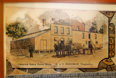
... Ltd., already owning mills in Horsham, Nhill, and Murray Bridge, acquired G. H. Foreman’s Mill located by the Avoca River. ...Ltd., already owning mills in Horsham, Nhill, and Murray Bridge, acquired G. H. Foreman’s Mill located by the Avoca River. ...Close up photograph of part of the Charlton Lithograph showing the Charlton Steam Power Flour Mill of G & C Foreman. Located in on the bank of the Avoca river. The mill owners attempted to dam the river during the 1870s. The mill was built in 1876 as recorded by the local traveling correspondent . Foreman's flour mill established 1876 at the west end of High Street. Sold to Norske in 1925. Replaced by Noske's Flour Mill on Kays Street in 1927. Noske's Flour Mill, with its commanding presence and towering silos, has long **dominated the Charlton skyline** and remains a significant landmark, even though it no longer mills flour. The mill's history is deeply intertwined with the development of Charlton and the grain industry of the surrounding district. The foundation for the mill's presence was laid in 1919 when Messrs Noske Bros. Pty. Ltd., already owning mills in Horsham, Nhill, and Murray Bridge, acquired G. H. Foreman’s Mill located by the Avoca River. The founder, **T. J. Noske**, was an early pioneer of flour exporting, expanding his milling business after unexpectedly acquiring the Horsham mill. ### A State-of-the-Art Operation The original mill by the river operated until August 1926 before being closed and dismantled. Plans were well underway for a **new, state-of-the-art mill** to be located at the former Cobb and Co site. In 1927, the new mill began operation. It was one of the largest in the state, boasting a capacity of three tons of flour per hour, a 250 h.p. diesel engine, and three initial silos. The mill quickly gained a reputation for **excellence** for both its design and its flour, which was sold successfully in local and overseas markets. ### Periods of Expansion and Trial The mill continued to grow, reflecting the importance of the local agricultural industry. Between 1940 and 1941, **nine new silos** were built, adding bulk receival points. In the record-breaking 1968 season, the mill received a colossal wheat intake of **695,000 bushels**. However, the mill also faced setbacks. On January 21, 1949, disaster struck when a **large fire** erupted in the storage shed, which contained 500 tons of bagged flour ready for export and new flour bags. The blaze was so intense that smoke was visible as far away as Wycheproof, and it threatened to destroy the entire mill. Thanks to the monumental efforts of the Charlton, St. Arnaud, Wycheproof, and Wedderburn Brigades, who ran the main pump almost continuously for 26 hours, the damage was contained, though the estimated loss was a substantial £60,000. ### Transformation of the Site At its peak, the mill was a major employer, providing work for approximately 65–70 men. But after over 45 years of operation, flour production at the mill ceased on October 25, 1973. Noske Industries Ltd. sought to adapt, converting the operation to a less successful stock feed production centre. In 1977, the **Grain Elevators Board** took over the site as a grain receival depot, building a large elevator tower that surpassed the height of the original buildings. The site eventually returned to private hands and, since 2000, has been owned and operated as a primary grain receival site for **GrainCorp**, cementing its continued, vital role in Charlton's agricultural life.Colour photo taken of a small portion of the Charlton Lithograph. Showing the Charlton Steam Flour Mill of G. C. Foreman.Charlton Steam Flour Mills. G & C Foreman proprietors.lithograph, business, industry, charlton, flour mill, noske bros, foreman -
 Charlton Golden Grains Museum Inc
Photograph, c.1948
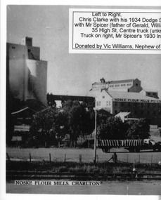
... Ltd., already owning mills in Horsham, Nhill, and Murray Bridge, acquired G. H. Foreman’s Mill located by the Avoca River. ...Ltd., already owning mills in Horsham, Nhill, and Murray Bridge, acquired G. H. Foreman’s Mill located by the Avoca River. ...Black and white photo copied and enlarged from small photo which was part of a set produced in c.1948. Chris Clarke with his 1934 Dodge semi trailer and W Spicer in his 1930 International truck line up to unload wheat at Noske's mill. Noskes flour mill built in 1927 with extra silos added in 1940's.Photo enlarged by Vic Williams of Bendigo nephew of Chris Clarke transport driver. Noske's Flour Mill, with its commanding presence and towering silos, has long **dominated the Charlton skyline** and remains a significant landmark, even though it no longer mills flour. The mill's history is deeply intertwined with the development of Charlton and the grain industry of the surrounding district. The foundation for the mill's presence was laid in 1919 when Messrs Noske Bros. Pty. Ltd., already owning mills in Horsham, Nhill, and Murray Bridge, acquired G. H. Foreman’s Mill located by the Avoca River. The founder, **T. J. Noske**, was an early pioneer of flour exporting, expanding his milling business after unexpectedly acquiring the Horsham mill. ### A State-of-the-Art Operation The original mill by the river operated until August 1926 before being closed and dismantled. Plans were well underway for a **new, state-of-the-art mill** to be located at the former Cobb and Co site. In 1927, the new mill began operation. It was one of the largest in the state, boasting a capacity of three tons of flour per hour, a 250 h.p. diesel engine, and three initial silos. The mill quickly gained a reputation for **excellence** for both its design and its flour, which was sold successfully in local and overseas markets. ### Periods of Expansion and Trial The mill continued to grow, reflecting the importance of the local agricultural industry. Between 1940 and 1941, **nine new silos** were built, adding bulk receival points. In the record-breaking 1968 season, the mill received a colossal wheat intake of **695,000 bushels**. However, the mill also faced setbacks. On January 21, 1949, disaster struck when a **large fire** erupted in the storage shed, which contained 500 tons of bagged flour ready for export and new flour bags. The blaze was so intense that smoke was visible as far away as Wycheproof, and it threatened to destroy the entire mill. Thanks to the monumental efforts of the Charlton, St. Arnaud, Wycheproof, and Wedderburn Brigades, who ran the main pump almost continuously for 26 hours, the damage was contained, though the estimated loss was a substantial £60,000. ### Transformation of the Site At its peak, the mill was a major employer, providing work for approximately 65–70 men. But after over 45 years of operation, flour production at the mill ceased on October 25, 1973. Noske Industries Ltd. sought to adapt, converting the operation to a less successful stock feed production centre. In 1977, the **Grain Elevators Board** took over the site as a grain receival depot, building a large elevator tower that surpassed the height of the original buildings. The site eventually returned to private hands and, since 2000, has been owned and operated as a primary grain receival site for **GrainCorp**, cementing its continued, vital role in Charlton's agricultural life.Black and white photo copied and enlarged from small photo.charlton, flour mill, noske's, noske bros -
 Charlton Golden Grains Museum Inc
Photograph, c.1948
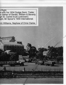
... Ltd., already owning mills in Horsham, Nhill, and Murray Bridge, acquired G. H. Foreman’s Mill located by the Avoca River. ...Ltd., already owning mills in Horsham, Nhill, and Murray Bridge, acquired G. H. Foreman’s Mill located by the Avoca River. ...Black and white photo copied and enlarged from small photo which was part of a set produced in c.1948. Chris Clarke with his 1934 Dodge semi trailer and W Spicer in his 1930 International truck line up to unload wheat at Noske's mill. Noskes flour mill built in 1927 with extra silos added in 1940's. Photo enlarged by Vic Williams of Bendigo nephew of Chris Clarke transport driver. Noske's Flour Mill, with its commanding presence and towering silos, has long **dominated the Charlton skyline** and remains a significant landmark, even though it no longer mills flour. The mill's history is deeply intertwined with the development of Charlton and the grain industry of the surrounding district. The foundation for the mill's presence was laid in 1919 when Messrs Noske Bros. Pty. Ltd., already owning mills in Horsham, Nhill, and Murray Bridge, acquired G. H. Foreman’s Mill located by the Avoca River. The founder, **T. J. Noske**, was an early pioneer of flour exporting, expanding his milling business after unexpectedly acquiring the Horsham mill. ### A State-of-the-Art Operation The original mill by the river operated until August 1926 before being closed and dismantled. Plans were well underway for a **new, state-of-the-art mill** to be located at the former Cobb and Co site. In 1927, the new mill began operation. It was one of the largest in the state, boasting a capacity of three tons of flour per hour, a 250 h.p. diesel engine, and three initial silos. The mill quickly gained a reputation for **excellence** for both its design and its flour, which was sold successfully in local and overseas markets. ### Periods of Expansion and Trial The mill continued to grow, reflecting the importance of the local agricultural industry. Between 1940 and 1941, **nine new silos** were built, adding bulk receival points. In the record-breaking 1968 season, the mill received a colossal wheat intake of **695,000 bushels**. However, the mill also faced setbacks. On January 21, 1949, disaster struck when a **large fire** erupted in the storage shed, which contained 500 tons of bagged flour ready for export and new flour bags. The blaze was so intense that smoke was visible as far away as Wycheproof, and it threatened to destroy the entire mill. Thanks to the monumental efforts of the Charlton, St. Arnaud, Wycheproof, and Wedderburn Brigades, who ran the main pump almost continuously for 26 hours, the damage was contained, though the estimated loss was a substantial £60,000. ### Transformation of the Site At its peak, the mill was a major employer, providing work for approximately 65–70 men. But after over 45 years of operation, flour production at the mill ceased on October 25, 1973. Noske Industries Ltd. sought to adapt, converting the operation to a less successful stock feed production centre. In 1977, the **Grain Elevators Board** took over the site as a grain receival depot, building a large elevator tower that surpassed the height of the original buildings. The site eventually returned to private hands and, since 2000, has been owned and operated as a primary grain receival site for **GrainCorp**, cementing its continued, vital role in Charlton's agricultural life.Black and white photocharton, business, noske bros, flour mill -
 Puffing Billy Railway
Equipment - Victorian Railways Carriage Foot Warmer
... "Shaking up" on this service took place at Murray Bridge and Stawell on the tip to Melbourne and at Ballarat and Serviceton on the trip to Adelaide. ..."Shaking up" on this service took place at Murray Bridge and Stawell on the tip to Melbourne and at Ballarat and Serviceton on the trip to Adelaide. ...During prestige, long distance train journeys some carriages had air-conditioning, and the majority of passengers had to brave unheated carriages. To offer some comfort during the winter months, the non-air-conditioned carriages were provided with footwarmers. These were metal containers roughly 100 mm thick and 300 mm wide, and about 750 mm long, which were filled with salt crystals (concentrated crystalline hydrated sodium acetate). The footwarmers were covered by sleeves of thick canvas, and two footwarmers were usually placed in each compartment of non-air-conditioned carriages. To activate the chemicals, the footwarmers were heated almost to boiling point. This was done by removing the canvas sleeves and placing the footwarmers in a large bath of very hot water. After they had been heated, they were removed from the bath and the sleeves refitted. They were then ready to be placed in the carriages. The McLaren patent foot warmer was used on railways in New South Wales, Queensland, Victoria and South Australia as well as South Africa and New Zealand. It was during the 1901 royal visit by the Duke and Duchess of Cornwall that these foot warmers were first used in New Zealand in the royal carriage. Before railway carriage heating was introduced, McLaren patent foot warmers were placed on the floor of New South Wales government railway carriages from 1891 to provide a little passenger comfort. The rectangular steel container worked a bit like a hot water bottle but instead of water contained six and a half kilograms of loosely-packed salt crystals, (concentrated crystalline hydrated sodium acetate). This was permanently sealed inside the container with a soldered cap. After the foot warmer was heated in vat of boiling water for about one and a quarter hours the crystals became a hot liquid. (The melting point for sodium acetate is 58 degrees). There was a whole infrastructure of special furnaces set up at stations for the daily heating of foot warmers. By 1914 the Victorian railways had 4,000 foot warmers in service and by 1935 there were 33 furnaces at principal stations to heat them. After about 10 hours the container was picked up by the handle and given a good vertical shake which helped the cooled liquid reform into a solid mass of hot crystals. Staff or sometimes passengers shook them en route when the foot warmers began to get cold. However, as they were heavy this was only possible by fit and agile passengers. At the end of the journey the containers were boiled again for reuse on the next trip. Sodium acetate railway foot warmers were introduced in Victoria in 1889, Adelaide to Melbourne express in 1899. "Shaking up" on this service took place at Murray Bridge and Stawell on the tip to Melbourne and at Ballarat and Serviceton on the trip to Adelaide. The use of foot warmers began to decline in New South Wales from the 1930s with the first trial of carriage air-conditioning in 1936, steam heating from 1948 ad LP gas heating from 1961. By the early 1960s the main services using foot warmers were the overnight mail trains. info from : http://www.powerhousemuseum.com/collection/database/?irn=67564#ixzz4UBNzVf6t Under Creative Commons License: Attribution Non-Commercial There was a whole infrastructure set up at stations for the daily heating of foot warmers in special furnaces. In Victoria alone in 1935 there were 33 heating works.Historic - Victorian Railways - Carriage Heater - Foot warmerA rectangular-shaped stainless steel casing with a welded seam down the back and welded ends. There is a handle at one end for carrying and shaking. Inside the foot warmer are two baffle plates and three trays to contain the sodium acetate. There was a cast-iron ball in each internal compartment. puffing billy, victorian railways, carriage haeter, foot warmer, passenger comfort, station furnace, railway ephemera, early heating methods -
 Ballarat Tramway Museum
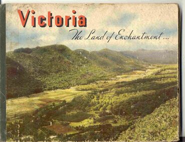
Book, Nu-color-vue or Nucolorvue Productions, "Victoria The Land of Enchantment", c1950
... Photos of Mt Buffalo, Gippsland lakes, Mornington Beach, Yarra River, Flinders St. station from the Yarra, Collins and Spring St (with two W2's - see image No. 2), Parliament House, Kiewa Hydro scheme, Eildon Weir, Swan Hill Murray River Bridge, Bendigo Post Office, Melbourne Botanical Gardens, Ballarat - Grenville and Sturt St (No. 22 - see image No. 3), Lorne, Yallourn Power Station, Hume Weir, Maroondah Weir, Great Ocean Road, Warrnambool, Portland Beach, A timber train (see image No. 4), Mildura, flax mills, Eastern Geelong and the Prime Ministers Ave, Ballarat. ...Photos of Mt Buffalo, Gippsland lakes, Mornington Beach, Yarra River, Flinders St. station from the Yarra, Collins and Spring St (with two W2's - see image No. 2), Parliament House, Kiewa Hydro scheme, Eildon Weir, Swan Hill Murray River Bridge, Bendigo Post Office, Melbourne Botanical Gardens, Ballarat - Grenville and Sturt St (No. 22 - see image No. 3), Lorne, Yallourn Power Station, Hume Weir, Maroondah Weir, Great Ocean Road, Warrnambool, Portland Beach, A timber train (see image No. 4), Mildura, flax mills, Eastern Geelong and the Prime Ministers Ave, Ballarat. ...Book with hardcovers, 48 pages titled "Victoria The Land of Enchantment". Sewn in three sections, with a green strip of cloth and self end papers and printed outer paper, sides glued onto board covers. Consists of 43 colour photographs (full and half page) with captions, detailed text, and two black and white photos printed in blue on end covers. Photos of Mt Buffalo, Gippsland lakes, Mornington Beach, Yarra River, Flinders St. station from the Yarra, Collins and Spring St (with two W2's - see image No. 2), Parliament House, Kiewa Hydro scheme, Eildon Weir, Swan Hill Murray River Bridge, Bendigo Post Office, Melbourne Botanical Gardens, Ballarat - Grenville and Sturt St (No. 22 - see image No. 3), Lorne, Yallourn Power Station, Hume Weir, Maroondah Weir, Great Ocean Road, Warrnambool, Portland Beach, A timber train (see image No. 4), Mildura, flax mills, Eastern Geelong and the Prime Ministers Ave, Ballarat. Produced by Nucolorvue Productions, c1950. See also Reg Item 2925 for the same photo of No. 22 and Reg Item 5354 for a postcard. Purchased via eBay site - see attached sheets and packing slip. Purchased 10/2/2005 for A$12.50 including postage, from Virginia Georgopoulos of West Brunswick. eBay sheets and envelope with worksheet file. Has Swains 123 Pitt St, Sydney sticker on bottom left hand corner page 2trams, tramways, ballarat, sturt st, grenville st, bogie trams, geelong, bendigo, melbourne