Showing 73 items matching "old scales."
-
 Woods' Farming and Heritage Museum
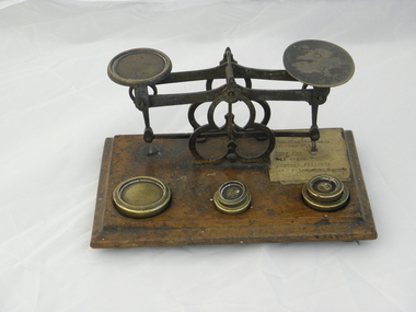
Letter Scale, Unknown
... ...old scales....Woods' Farming and Heritage Museum 109 Wimmera Highway Rupanyup grampians Letter Scales used in Post Offices. Old scales letter scales post office scales antique scales weights brass weights brass scales old scales. ...Letter Scales used in Post Offices.OldBrass balance letter scales, mounted on wooden base, with 5 individual round brass weights, stamped in oz's.No visible inscriptions on scales, but has oz's stamped on weights. Has a piece of paper attached to wooden base with letter prices.scales, letter scales, post office scales, antique scales, weights, brass weights, brass scales, old scales. -
 Greensborough Historical Society
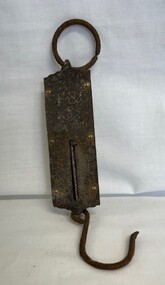
Domestic object - Scales, L.F. & C, Pocket Balance Scales, 1900 c
... Small, very old pocket balance scales 0 L.F. & C. Made in New York. ...Small very old pocket balance scales, front plate is brass. The wording on the scales is Not Legal For Use In Trade,. ...The scales measure up to 25lb. scales kitchenware Small very old pocket balance scales, front plate is brass. ...Small, very old pocket balance scales 0 L.F. & C. Made in New York. Possible belonged to and used by the Bishop family 1900s to 1930s. The front plate is brass. The wording on the scales is "Not Legal For Use In Trade". The scales measure up to 25lb.Small very old pocket balance scales, front plate is brass. The wording on the scales is Not Legal For Use In Trade,. Scales measure up to 25lb.scales, kitchenware -
 University of Melbourne, Burnley Campus Archives
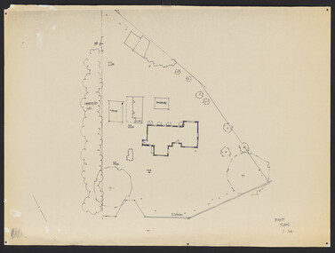
Plan, Old Caretakers Cottage: Base Plan 1:100, 198-?
... Tracing paper and paper plans of Old Cottage and surroundings. Scale 1:100. 2. Tracing paper copy of Caretaker's residence....Tracing paper and paper plans of Old Cottage and surroundings. Scale 1:100. 2. Tracing paper copy of Caretaker's residence. ...1. Tracing paper and paper plans of Old Cottage and surroundings. Scale 1:100. 2. Tracing paper copy of Caretaker's residence.cottage, caretaker, burnley, vcah -
 Bendigo Historical Society Inc.
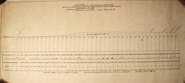
Plan - Section of Levels S.B.G.M.Co
... Co From X cut 5 level Main Shaft to cut leading back to Old Shaft Scales Horizontal 1"=20ft Vertical 1'=10ft Date 6th July 1935 J.B. ...Co From X cut 5 level Main Shaft to cut leading back to Old Shaft Scales Horizontal 1"=20ft Vertical 1'=10ft Date 6th July 1935 J.B. ...A t draftsman's drawing. Written at the top - SECTION of LEVELS S.B.G.M. Co From X cut 5 level Main Shaft to cut leading back to Old Shaft Scales Horizontal 1"=20ft Vertical 1'=10ft Date 6th July 1935 J.B. Underneath there is a data chart with 29 columns with horizontal lines labeled- Datum Line, Total Distances in ft, Levels Reduced, Height above+ below Datum, Filling ft, Cutting ft Forms part of the Margaret Roberts Collection.bendigo, margaret roberts, gold, mine -
 Warrnambool and District Historical Society Inc.
Document, Warrnambool calling, 1933
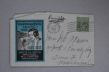
... There had been a large-scale ‘Back To’ in Warrnambool in 1930, perhaps prompted by the growing interest in the history of the town ( this was evidenced in many country towns in Victoria at the time) and the need to gather together the remaining older local people as those regarded as pioneers of the district were fast dying out. ...There had been a large-scale ‘Back To’ in Warrnambool in 1930, perhaps prompted by the growing interest in the history of the town ( this was evidenced in many country towns in Victoria at the time) and the need to gather together the remaining older local people as those regarded as pioneers of the district were fast dying out. ...This is a souvenir of a ‘Back To’ celebration in Warrnambool in 1934. There had been a large-scale ‘Back To’ in Warrnambool in 1930, perhaps prompted by the growing interest in the history of the town ( this was evidenced in many country towns in Victoria at the time) and the need to gather together the remaining older local people as those regarded as pioneers of the district were fast dying out. In 1934 the State of Victoria was celebrating the centenary of the first permanent white settlement at Portland and many other places besides Melbourne took this opportunity to have a reunion of past and present citizens. Also Warrnambool had at the time two men very interested in the history of the settlement – Henri Worland and Patrick O’Grady and the first Warrnambool Historical Society was established the following year with Worland and O’Grady prominent in its establishment and Martin Carter on the first committee as well. Martin Carter, whose name appears on this envelope was the organizer of the 1934 reunion. The Carter family had long been established in Warrnambool as saddlers and Martin Carter was a Warrnambool Councillor from 1917 to 1925 and Mayor during three of those years. No information is available on the ‘Miss Adams ‘ in the address but ‘ R. F. Kennedy & Co.’ refers to the well-known pharmacy business in Timor Street Warrnambool.This envelope is of interest as a souvenir of a ‘Back To’ in Warrnambool in 1934. This is a small envelope with most of the back flap missing. The inside of the envelope has a blue lining. The envelope has a franked green Australian stamp and a Warrnambool Post Office stamp. A handwritten address is on the right side of the envelope. On the left side is a printed poster/advertisement in blue, black and grey colouring. The advertisement features an illustration of a woman speaking into a telephone with a coastal scene background. ‘Warrnambool Calling 1934 Come Home For a Week Jan 13 to Jan 21 Particulars M.L.Carter Warrnambool’ ‘Miss A. G. Adams C/O Messrs R.F.Kennedy & Coy Timor Street Warrnambool back to warrnambool 1934, history of warrnambool -
 Bendigo Military Museum
Booklet - HANDBOOK & ROAD MAP, April 1940
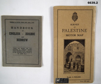
... It has cardboard cover and opens out to a road map, scale 1:500,000. It has a drawing of the old section of Jerusalem on front cover....It has cardboard cover and opens out to a road map, scale 1:500,000. It has a drawing of the old section of Jerusalem on front cover. ...Sold by Ringarts Bookshop, Haifa1. This is a small pocket book, grey cover, black ink printing. It has words and phrases of colloquial Arabic and/or Hebrew. 32 pages. It is for Australian Imperial Forces in the Middle East. 2. Palestine Road Map. It has cardboard cover and opens out to a road map, scale 1:500,000. It has a drawing of the old section of Jerusalem on front cover.passchendaele barracks trust, 1. nr9430t, 2.9431t, ww2 -
 Emerald Museum & Nobelius Heritage Park
Photograph, P. & O. Cowper, Church of Christ and P.O. Emerald, c. Mid 20th Century
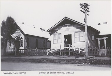
... scale capacity. If the latter is true, "P. Cowper" could have been Mr. P. Cowper who participated in forming the Emerald Co-operative Society in 1945. The Emerald Church of Christ operated from 1913 until 1964 on the site (and building) now part of Fernlea Community House. The old...scale capacity. If the latter is true, "P. Cowper" could have been Mr. P. Cowper who participated in forming the Emerald Co-operative Society in 1945. The Emerald Church of Christ operated from 1913 until 1964 on the site (and building) now part of Fernlea Community House. The old ..."P. & O. Cowper" does not appear in internet research as a known publishing company; it is possible either that none of their work has made its way online, or that they were locals publishing on a small scale capacity. If the latter is true, "P. Cowper" could have been Mr. P. Cowper who participated in forming the Emerald Co-operative Society in 1945. The Emerald Church of Christ operated from 1913 until 1964 on the site (and building) now part of Fernlea Community House. The old post office was on that location from the 1910s until after the Church stopped operating, although by the 1960s there were telephone booths in front of the post office. This image could date from 1913 until the 1950s, although it is likely toward the later end of that range in the 1940s or 50s. This copy was produced in 2006 from the original.This photograph captures two long-standing Emerald institutions from the first half of the 20th century, one of which is no longer in operation and the other which has moved and had its place replaced with an unrecognisable new structure.This black and white photograph is printed on glossy modern photo paper. Its lower margin is occupied by printed text explaining the publisher and the subject matter. The photograph itself centres on two buildings, each constructed from wooden planks with sloped, likely tin rooves. A power pole stands to the right in front of the rightmost building. The ege of a road is visible in the foreground, indicating that this picture was taken from on or across the road. The reverse has printed technical information about the photograph, typical of a digital printed photograph.Obverse: Left, Typed: "Published by P. & O. COWPER" Centre, Typed: "CHURCH OF CHRIST AND P.O. EMERALD" Sign in Image, Left: "[obscured] CHRIST" Reverse: "10 27 PCEMER~4.JPG 6 16.12.06 18.12.06"emerald, 1940s, 1950s, emerald post office, emerald church of christ -
 Ballarat Clarendon College
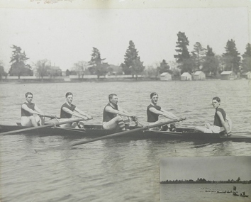
Photograph, 1921 B.P.S. Old Boy's Race
... Ballarat Clarendon College 1425 Sturt Street Ballarat goldfields Inscribed on large piece of mount: BALLARAT OLD COLLEGIANS WINNERS / -NAMES- / J WOODWARD [BOW] H KNOX [NO 2] A DAWSON SEN [NO 3] A DAWSON [STR] A KING [COX] Inscribed on smaller piece of mount: B.P.S. / OLD BOYS RACE 1921 Gray-scale photograph on heavy card with smaller photograph inset at bottom right corner; two detached pieces of mount with inscriptions 1921 B.P.S. ...Gray-scale photograph on heavy card with smaller photograph inset at bottom right corner; two detached pieces of mount with inscriptionsInscribed on large piece of mount: BALLARAT OLD COLLEGIANS WINNERS / -NAMES- / J WOODWARD [BOW] H KNOX [NO 2] A DAWSON SEN [NO 3] A DAWSON [STR] A KING [COX] Inscribed on smaller piece of mount: B.P.S. / OLD BOYS RACE 1921 -
 Ballarat Clarendon College
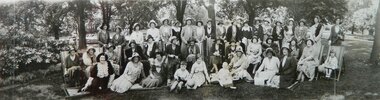
Photograph - Framed, Black and White, 1931
... Ballarat Clarendon College 1425 Sturt Street Ballarat goldfields Group Photo People Hats Children Women Deck Chairs 1930s Fashion Handwritten on back: Nov 1931 Clarendon College Old Collegians reunion Gray-scale photograph, with bone mounting in thin black frame Photograph Framed, Black and White ...Gray-scale photograph, with bone mounting in thin black frameHandwritten on back: Nov 1931 Clarendon College Old Collegians reuniongroup photo, people, hats, children, women, deck chairs, 1930s fashion -
 Flagstaff Hill Maritime Museum and Village
Container - Ink Bottle, Second half of 19th Century or first half of the 20th Century
... Although glass containers for wine and beer are probably 1,600 years old, much of their use began only in the late 17th century. In the United States, large-scale production of bottles was pioneered by Caspar Wistar in 1739 at his New Jersey plant. ...Flagstaff Hill Maritime Museum and Village 89 Merri Street Warrnambool great-ocean-road Although glass containers for wine and beer are probably 1,600 years old, much of their use began only in the late 17th century. In the United States, large-scale production of bottles was pioneered by Caspar Wistar in 1739 at his New Jersey plant. ...Although glass containers for wine and beer are probably 1,600 years old, much of their use began only in the late 17th century. In the United States, large-scale production of bottles was pioneered by Caspar Wistar in 1739 at his New Jersey plant. In the 1770s the carbonation process for producing soft drinks was developed, and so began an entirely new bottling industry. At the Great Exhibition of 1851 in the Crystal Palace in London, one million “pop” bottles were consumed. The first beer pasteurised in glass was produced in Copenhagen in 1870. Pasteurisation of milk followed soon after. The moulding of a screw thread on a container was invented by John Mason in 1858. The principles of the “press-and-blow” process for making wide-mouth jars were shown in the United States by Philip Arbogast in 1882, and the “blow-and-blow” process for making narrow-neck containers was demonstrated by Howard Ashley in England in 1885. These processes employed manual delivery; fully automatic jar forming by a suction-and-blow process was perfected by Michael Owens over the period 1895–1917 at the Toledo (Ohio) Glass Company, which subsequently became the Owens Bottle Machine Company. The automatic single-gob feeder was developed in 1919–22 by Karl Peiler at the Hartford-Fairmont Company in Connecticut. Fully automatic machines followed, but the true rugged survivor, utilising fully automatic gob delivery to the maximum versatility, was the Individual Section, or IS, machine invented by Henry Ingle at the Hartford Empire Company in 1925. Source: https://www.britannica.com/topic/glass-properties-composition-and-industrial-production-234890/History-of-glassmakingUnlike item 4018, this is a much smaller ink bottle, and was probably used by an individual, as against the supply of ink to pupils from a much larger bottle.Cotton Reel Ink Bottle, green glass, small, chipped around the lip, bubbles in glass.None.flagstaff hill, warrnambool, shipwrecked-coast, flagstaff-hill, flagstaff-hill-maritime-museum, maritime-museum, shipwreck-coast, flagstaff-hill-maritime-village, ink, bottle, glass -
 Upper Yarra Museum
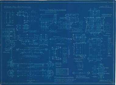
Technical drawing - blue print, Details of Timber Truck Ironwork, 17.07.1912
... Upper Yarra Museum Old Railway Station 2415C Warburton Highway Yarra Junction yarra-valley-and-dandenong-ranges Victorian Powell Wood Process Ltd details of timber truck ironwork scale 1 1/2" -3" = 1 foot Sheet No 17 11/07/12 Note:- the number off each part are for one wagon only DWR-00286 Details of Timber truck ironwork, Victorian Hardwood Company, Powelltown, 1919. ...DWR-00286 Details of Timber truck ironwork, Victorian Hardwood Company, Powelltown, 1919. Blue Print.Victorian Powell Wood Process Ltd details of timber truck ironwork scale 1 1/2" -3" = 1 foot Sheet No 17 11/07/12 Note:- the number off each part are for one wagon only -
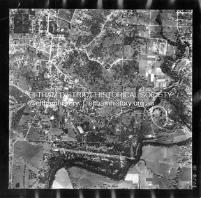
 Eltham District Historical Society Inc
Photograph - Aerial Photograph, Landata, Montmorency, Feb. 1956
... Old Eltham Road and Eltham Lower Park to south, Bible Street to east and Para Road to west. Historic Aerial Imagery Source: Landata.vic.gov.au Aerial Photo Details: Project No :250 Project : MELBOURNE OUTER SUBURBS PROJECT Run : 17 Frame : 115 Date : 02/1956 Film Type : B/W Camera : EAG9 Flying Height : 10000 Scale : 12000 Film Number : 1176 GDA2020 : 37°43'24"S, 145°07'55"E MGA2020 : 335375, 5823236 (55) Melways : 21 F7 (ed. 42)...Old Eltham Road and Eltham Lower Park to south, Bible Street to east and Para Road to west. Historic Aerial Imagery Source: Landata.vic.gov.au Aerial Photo Details: Project No :250 Project : MELBOURNE OUTER SUBURBS PROJECT Run : 17 Frame : 115 Date : 02/1956 Film Type : B/W Camera : EAG9 Flying Height : 10000 Scale : 12000 Film Number : 1176 GDA2020 : 37°43'24"S, 145°07'55"E MGA2020 : 335375, 5823236 (55) Melways : 21 F7 (ed. 42) Aerial Photo 1956-02 Neil Webster Collection Eltham Main Road Montmorency Bible Street Diamond Street Eltham Lower Park Grand Boulevard Melway 21F7 Old Eltham Road Olympic Way Para Road Digital jpg and electronic PDF file Montmorency Photograph Aerial Photograph Landata ...Centred on present day Grand Boulevard and Olympic Way, Montmorency bounded by Diamond Street to north, Old Eltham Road and Eltham Lower Park to south, Bible Street to east and Para Road to west. Historic Aerial Imagery Source: Landata.vic.gov.au Aerial Photo Details: Project No :250 Project : MELBOURNE OUTER SUBURBS PROJECT Run : 17 Frame : 115 Date : 02/1956 Film Type : B/W Camera : EAG9 Flying Height : 10000 Scale : 12000 Film Number : 1176 GDA2020 : 37°43'24"S, 145°07'55"E MGA2020 : 335375, 5823236 (55) Melways : 21 F7 (ed. 42)aerial photo, 1956-02, neil webster collection, eltham, main road, montmorency, bible street, diamond street, eltham lower park, grand boulevard, melway 21f7, old eltham road, olympic way, para road -
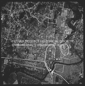
 Eltham District Historical Society Inc
Photograph - Aerial Photograph, Landata, Lower Plenty, Feb. 1956
... Old Eltham Road, Lower Plenty bounded by Pitt Street to north, Yarra River to south, Main Road to east and Bonds Road to west. Historic Aerial Imagery Source: Landata.vic.gov.au Aerial Photo Details: Project No :250 Project : MELBOURNE OUTER SUBURBS PROJECT Run : 17 Frame : 116 Date : 02/1956 Film Type : B/W Camera : EAG9 Flying Height : 10000 Scale : 12000 Film Number : 1176 GDA2020 : 37°43'58"S, 145°07'49"E MGA2020 : 335237, 5822186 (55) Melways : 21 E10 (ed. 42)...Old Eltham Road, Lower Plenty bounded by Pitt Street to north, Yarra River to south, Main Road to east and Bonds Road to west. Historic Aerial Imagery Source: Landata.vic.gov.au Aerial Photo Details: Project No :250 Project : MELBOURNE OUTER SUBURBS PROJECT Run : 17 Frame : 116 Date : 02/1956 Film Type : B/W Camera : EAG9 Flying Height : 10000 Scale : 12000 Film Number : 1176 GDA2020 : 37°43'58"S, 145°07'49"E MGA2020 : 335237, 5822186 (55) Melways : 21 E10 (ed. 42) Aerial Photo 1956-02 Neil Webster Collection Eltham Main Road Bonds Road Elham Lower Plenty Melway 21E10 Pitt Street Yarra River Digital jpg and electronic PDF file Lower Plenty Photograph Aerial Photograph Landata ...Centred on present day 217 Old Eltham Road, Lower Plenty bounded by Pitt Street to north, Yarra River to south, Main Road to east and Bonds Road to west. Historic Aerial Imagery Source: Landata.vic.gov.au Aerial Photo Details: Project No :250 Project : MELBOURNE OUTER SUBURBS PROJECT Run : 17 Frame : 116 Date : 02/1956 Film Type : B/W Camera : EAG9 Flying Height : 10000 Scale : 12000 Film Number : 1176 GDA2020 : 37°43'58"S, 145°07'49"E MGA2020 : 335237, 5822186 (55) Melways : 21 E10 (ed. 42)aerial photo, 1956-02, neil webster collection, eltham, main road, bonds road, elham, lower plenty, melway 21e10, pitt street, yarra river -
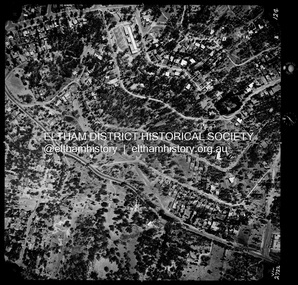
 Eltham District Historical Society Inc
Photograph - Aerial Photograph, Landata, Lower Plenty, Vic, Apr. 1963
... Old Eltham Road near Araluen Centre, Lower Plenty bounded by Cromwell Street to north, Yarra River to south, Main Road at Mount Pleasant Road to east and Panorama Avenue to west. Historic Aerial Imagery Source: Landata.vic.gov.au Aerial Photo Details: Project No :486 Project : MELBOURNE (1963) PROJECT Run : 7 Frame : 231 Date : 04/1963 Film Type : B/W Camera : RC8 Flying Height : 5100 Scale : 9600 Film Number : 1805 GDA2020 : 37°44'03"S, 145°07'56"E MGA2020 : 335420, 5822027 (55) Melways : 21 F10 (ed. 42)...Old Eltham Road near Araluen Centre, Lower Plenty bounded by Cromwell Street to north, Yarra River to south, Main Road at Mount Pleasant Road to east and Panorama Avenue to west. Historic Aerial Imagery Source: Landata.vic.gov.au Aerial Photo Details: Project No :486 Project : MELBOURNE (1963) PROJECT Run : 7 Frame : 231 Date : 04/1963 Film Type : B/W Camera : RC8 Flying Height : 5100 Scale : 9600 Film Number : 1805 GDA2020 : 37°44'03"S, 145°07'56"E MGA2020 : 335420, 5822027 (55) Melways : 21 F10 (ed. 42) Aerial Photo Neil Webster Collection 1963-04 Araluen Cromwell Street Eltham Lower Plenty Main Road Melway 21F10 Mount Pleasant Road Old Eltham Road Panorama Avenue Yarra River Digital jpg and electronic PDF file Lower Plenty, Vic. ...Centred on present day Old Eltham Road near Araluen Centre, Lower Plenty bounded by Cromwell Street to north, Yarra River to south, Main Road at Mount Pleasant Road to east and Panorama Avenue to west. Historic Aerial Imagery Source: Landata.vic.gov.au Aerial Photo Details: Project No :486 Project : MELBOURNE (1963) PROJECT Run : 7 Frame : 231 Date : 04/1963 Film Type : B/W Camera : RC8 Flying Height : 5100 Scale : 9600 Film Number : 1805 GDA2020 : 37°44'03"S, 145°07'56"E MGA2020 : 335420, 5822027 (55) Melways : 21 F10 (ed. 42)aerial photo, neil webster collection, 1963-04, araluen, cromwell street, eltham, lower plenty, main road, melway 21f10, mount pleasant road, old eltham road, panorama avenue, yarra river -
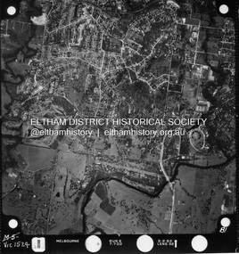 Eltham District Historical Society Inc
Photograph - Aerial Photograph, Landata, Montmorency / Lower Plenty, Jan. 1962
... Old Eltham Road, Lower Plenty bounded by Hurstbridge Railway Line to north, Yarra River to south, Main Road, Eltham to east and Heidelberg Golf Club to west. Historic Aerial Imagery Source: Landata.vic.gov.au Aerial Photo Details: Project No : 539 Project : MELBOURNE-GEELONG PROJECT Run : 6 Frame : 81 Date : 01/1962 Film Type : B/W Camera : RC5 Flying Height : 6000 Scale : 15840 Film Number : 1524 GDA2020 : 37°43'52"S, 145°07'26"E MGA2020 : 334685, 5822354 (55) Melways : 21 D9 (ed. 42)...Old Eltham Road, Lower Plenty bounded by Hurstbridge Railway Line to north, Yarra River to south, Main Road, Eltham to east and Heidelberg Golf Club to west. Historic Aerial Imagery Source: Landata.vic.gov.au Aerial Photo Details: Project No : 539 Project : MELBOURNE-GEELONG PROJECT Run : 6 Frame : 81 Date : 01/1962 Film Type : B/W Camera : RC5 Flying Height : 6000 Scale : 15840 Film Number : 1524 GDA2020 : 37°43'52"S, 145°07'26"E MGA2020 : 334685, 5822354 (55) Melways : 21 D9 (ed. 42) Aerial Photo Lower Plenty Main Road Montmorency Phoebe Mason Collection Eltham Eltham Lower Park Heidelberg Golf Club Hurstbridge Railway Line Main Road Eltham Yarra River Electronic PDF file Montmorency / Lower Plenty Photograph Aerial Photograph Landata ...Centred on 147 Old Eltham Road, Lower Plenty bounded by Hurstbridge Railway Line to north, Yarra River to south, Main Road, Eltham to east and Heidelberg Golf Club to west. Historic Aerial Imagery Source: Landata.vic.gov.au Aerial Photo Details: Project No : 539 Project : MELBOURNE-GEELONG PROJECT Run : 6 Frame : 81 Date : 01/1962 Film Type : B/W Camera : RC5 Flying Height : 6000 Scale : 15840 Film Number : 1524 GDA2020 : 37°43'52"S, 145°07'26"E MGA2020 : 334685, 5822354 (55) Melways : 21 D9 (ed. 42)aerial photo, lower plenty, main road, montmorency, phoebe mason collection, eltham, eltham lower park, heidelberg golf club, hurstbridge railway line, main road eltham, yarra river -
 Eltham District Historical Society Inc
Photograph - Aerial Photograph, Landata, Montmorency / Lower Plenty, Jan. 1973
... Old Eltham Road to south, Bolton Street to east and Panorama Avenue to west. Historic Aerial Imagery Source: Landata.vic.gov.au Aerial Photo Details: Project No :1043 Project : MONTMORENCY Run : 2 Frame : 124 Date : 01/1973 Film Type : B/W Camera : RC8 Flying Height : 2200 Scale : 4000 Film Number : 2722 GDA2020 : 37°43'48"S, 145°07'49"E MGA2020 : 335243, 5822507 (55) Melways : 21 E9 (ed. 42)...Old Eltham Road to south, Bolton Street to east and Panorama Avenue to west. Historic Aerial Imagery Source: Landata.vic.gov.au Aerial Photo Details: Project No :1043 Project : MONTMORENCY Run : 2 Frame : 124 Date : 01/1973 Film Type : B/W Camera : RC8 Flying Height : 2200 Scale : 4000 Film Number : 2722 GDA2020 : 37°43'48"S, 145°07'49"E MGA2020 : 335243, 5822507 (55) Melways : 21 E9 (ed. 42) Aerial Photo Lower Plenty Main Road Montmorency Phoebe Mason Collection Bolton Steet Grand Boulevard Old Eltham Road Panorama Avenue Electronic PDF file Montmorency / Lower Plenty Photograph Aerial Photograph Landata ...Centred on 385 Main Road, Lower Plenty bounded by Grand Boulevard, Montmorency to north, Old Eltham Road to south, Bolton Street to east and Panorama Avenue to west. Historic Aerial Imagery Source: Landata.vic.gov.au Aerial Photo Details: Project No :1043 Project : MONTMORENCY Run : 2 Frame : 124 Date : 01/1973 Film Type : B/W Camera : RC8 Flying Height : 2200 Scale : 4000 Film Number : 2722 GDA2020 : 37°43'48"S, 145°07'49"E MGA2020 : 335243, 5822507 (55) Melways : 21 E9 (ed. 42)aerial photo, lower plenty, main road, montmorency, phoebe mason collection, bolton steet, grand boulevard, old eltham road, panorama avenue -
 Eltham District Historical Society Inc
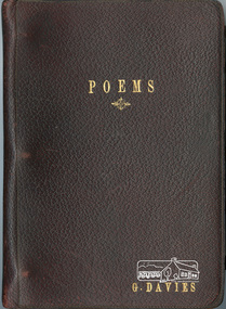
Book, Gwendoline G. W. Davies, Poems - G. Davies, 1933-1934
... scaled ‘mid shot and shell, And our comrades fell around us - - - - I remember it - - - so well. There are some who’ll sleep forever, On a hill that’s called Lone Pine, And the twenty-fifth of April, Is famous for all time. And so to keep their memory green, We march each Anzac Day, To pay tribute to those Heroes, Who gave their lives that day. - Anzac Day 1933 And in reflections to Gwenda’s childhood home in Arthur Street: HOME Where do my thoughts ever wander? Where do my thoughts always roam? To a little old...scaled ‘mid shot and shell, And our comrades fell around us - - - - I remember it - - - so well. There are some who’ll sleep forever, On a hill that’s called Lone Pine, And the twenty-fifth of April, Is famous for all time. And so to keep their memory green, We march each Anzac Day, To pay tribute to those Heroes, Who gave their lives that day. - Anzac Day 1933 And in reflections to Gwenda’s childhood home in Arthur Street: HOME Where do my thoughts ever wander? Where do my thoughts always roam? To a little old ...Gwendoline (Gwenda) Grace Watson Davies, only daughter of Mr. William Watson Davies and Mrs. Grace Davies (nee Hayes) of Arthur Street, Eltham was born in Newport, 18 February 1908. Gwenda grew up in Arthur Street and when she left school she was employed as an officer at the State Bank of Victoria, Chief Accountants Department, Head Office, Elizabeth Street, Melbourne. During 1933-1934 in her early to mid-twenties, Gwenda wrote a series of poems which were captured in three books: one a leather bound three-ring binder with personalised gold embossing on the cover and two paper booklets held together by pink ribbon. These poems are a reflection of her childhood days, home, her mother, her environment, pioneering days and other miscellaneous subjects including one example titled “EIGHTEEN YEARS TO-DAY”, an homage to the brave men of Gallipoli. On October 20, 1937 after ten years of service, Gwenda submitted her letter of resignation effective November 26th as she was to be married in the near future to Fred Jones. Frederick Geoffrey Jones, born 7 January 1911, third son of Mr. and Mrs. W. Jones of Napoleon Street, Eltham, married Gwenda at the Eltham Methodist Church on 27 November 1937. They made their home at ‘Llangollen’, Arthur Street, Eltham, a new house Fred had constructed earlier that year opposite the Shire Offices. Their residence was recorded in the Electoral Rolls from 1963-1980 as 6 Arthur Street, Eltham which was situated on the corner of Arthur Street and present-day Commercial Place. In the 1970s their home was sold and demolished to make way for the new shops. They built a new home at the top of the hill in Bible Street. In the Electoral Rolls for 1943-1980, Frederick’s occupation was recorded as a Plumber’s Assistant. Fred was also a long-standing member of the Eltham Cemetery Trust. He was first appointed 26 April 1944 and resigned 17 July 1957 to be appointed to the Warringal and Eltham Joint Trust where he served till February 1980. He then re-joined the Eltham Cemetery Trust and served a further 14 years till his resignation on 24 August 1994. In total, Fred represented the interests of Eltham Cemetery for 50 years (1944-1994). Gwenda and Fred were blessed with a son, Frederick William Jones in March 1942. Sadly, Frederick only lived two days and was buried at Eltham Cemetery on March 11. It is not known whether his grave is marked. A second son, Geoffrey Morris Jones arrived 25 November 1944 but he sadly contracted polio as a child. A fall down the front steps of Fred and Gwenda’s new home in Bible Street culminated in Geoff’s death from a heart attack whilst in transit to the Austin Hospital on February 6, 1979, at age 34. He was also interred in the Eltham Cemetery. Geoff was posthumously awarded the British Empire Medal for his services to fire safety at the CFA. A small man, handicapped from his childhood polio, he had figured prominently in the area as an active Apex member and as group officer for the 13 local brigades in the CFA Lower Yarra Group. His work for the CFA, all voluntary, included writing a fire-fighting manual and the innovation of aerial fire spotting and weekly fire reports. Gwendoline and Fred were presented with Geoff’s B.EM. award at Government House. Four years later on the anniversary of Geoff’s death, Gwenda could not sleep and collapsed in the hallway at home from a heart attack, 6 February 1983 at age 74. She was interred with her son Geoff, at Eltham Cemetery on February 9th. Fred died 31 July 1997 at age 86 and was also interred at Eltham Cemetery. A memorial plaque to Gwenda, Fred and Geoff lies within the lawn cemetery at Eltham Cemetery. In February 2022 Gwenda’s book of Poems along with a copy of her letter of resignation from the State Bank of Victoria and a news clipping about the Autumn Show held in the Public Hall at Eltham (opposite her home with Fred) in which Gwenda is listed as having entered Cream Puffs and a Swiss Roll into the Cooking section, were donated to the St Vincent’s de Paul Society in Bega, N.S.W.. A dedicated volunteer there researched their origins and desirous for these items to return ‘home’, posted them to the Eltham District Historical Society for which we are most appreciative. EIGHTEEN YEARS TO-DAY “Tell me why you’re dreaming, Daddy” Said my little son to me, So, I told him all about it, As he sat upon my knee. I told him of that Sunday morn, ‘Twas eighteen years to-day, When the men of Australasia, Joined the mighty fray. How they landed on that foreign shore, And fought the gallant fight, Of how they nobly won the day, And put the Turks to flight. We saw the cliffs before us, To be scaled ‘mid shot and shell, And our comrades fell around us - - - - I remember it - - - so well. There are some who’ll sleep forever, On a hill that’s called Lone Pine, And the twenty-fifth of April, Is famous for all time. And so to keep their memory green, We march each Anzac Day, To pay tribute to those Heroes, Who gave their lives that day. - Anzac Day 1933 And in reflections to Gwenda’s childhood home in Arthur Street: HOME Where do my thoughts ever wander? Where do my thoughts always roam? To a little old house, on the top of a hill, To the place, that I call “Home Sweet Home.” No matter where-ever I travel, On land, or away on the foam. My thoughts will return, and my heart ever yearn, To the place, that I call “Home Sweet Home”. - 2/7/1933 Sources: Book of Poems, G. Davies Letter of Resignation, 1937, Oct. 20, G.G.W. Davies Births Deaths and Marriages Victoria New House at Eltham (1937, September 10). Advertiser (Hurstbridge, Vic. : 1922 – 1939), p. 6. Retrieved May 12, 2022, from http://nla.gov.au/nla.news-article56845735 Family Notices (1937, December 17). Advertiser (Hurstbridge, Vic. : 1922 – 1939), p. 3. Retrieved May 12, 2022, from http://nla.gov.au/nla.news-article56846386 Geoff Jones, Proud Memory, unknown newspaper clipping, 1979 1979 Birthday Honours, Wikipedia, https://en.wikipedia.org/wiki/1979_Birthday_Honours Australian Electoral Rolls, Ancestry.com Family Trees, Ancestry.com Eltham Cemetery, Deceased Search findagrave.com Personal recollections, Joan Castledine The poetry by Gwendoline Davies provides an insight into life growing up in Eltham and the early 1930s. A long time resident, Gwendoline, her husband Fred Jones and son Geoff Jones were fully dedicated to the Eltham community for over 50 years.1. Brown leather bound three-ring binder with personalised gold embossing on the cover 20.5 x 14.5 cm, Walkers Loose Leaf Book, pages typed with some pasted in colour illustrations, alphabeticised dividers (some tabs missing), 21 leafs (some blank) 2. Two paper booklets held together by pink ribbon 15.5 x 12 cm, typed, some with colour illustrations, pages numbered (rh only) 12 pages and 25 pages and paper cover 3. Newspaper clipping 4. Letter sized hand written page in ink folded in three and damaged by foxing and insectsanzac day, arthur street, napoleon street, cfa, eltham cemetery, eltham cemetery trust, frederick geoffrey jones, geoffrey morris jones b.e.m., grace davies (nee hayes), gwendoline grace watson jones (nee davies), llangollen, lower yarra group, poems, william watson davies -
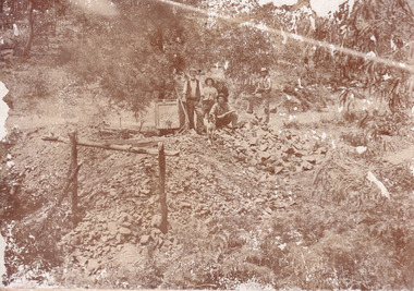 The Beechworth Burke Museum
Photograph
... ...small-scale mining...old...It has potential to improve our understanding of miners working conditions and the shifting character of mining in the Beechworth district. burke museum beechworth museum beechworth gold fields gold rush victorian gold rush gold ming history colonial australia australian gold rushes mining technology beechworth historic district indigo gold trail migration indigo shire good luck gold mine victorian goldfields mining syndicates gold fever quartz-mining small-scale mining old good luck mine mopoke gully quartz reefs beechworth Obverse: Williams/ Good/ Luck Reverse: A02498/ 1997. 2498/ Good Luck/ Mine/ 1899/ Mopoke. ...This image is a reproduction of an 1899 original depicting the 'Williams Good Luck Mine' on the Mopoke Reef (also called 'Morepork Gully') in the Dingle Ranges, approximately three miles from Beechworth. A large opening to a mine can be seen behind the men in the photograph, with a wheeled cart on a track leading to the men's position, where the soil and rocks have been hauled away. This photograph interestingly contains dogs alongside the miners. While dogs have been recorded as deterrents to thieves in the Victorian goldfields, these dogs appear as companions to these men. Following the discovery of gold at Beechworth in 1852, rushes quickly followed at surrounding creeks and gullies in the district. In the late nineteenth and early twentieth centuries, small syndicates of miners continued to work old or abandoned quartz reefs, often persisting without the assistance of heavy machinery to remove the large amounts of rock, in order to obtain yields at ever greater depths. The group of miners in this photograph are Mr. Roger Williams and Sons, who revived operations at the ‘Old Good Luck’ mine on the Mopoke Reef in the Dingle Range near Beechworth around 1892, working the site for more than two decades. An emigrant from Cornwall with experience in the tin mining industry, 19 year old Roger Williams senior sailed to New Zealand in 1840, then to Australia where he spent time in the Bendigo Gold Fields before settling in Beechworth in the early 1860s. Mr Williams senior worked on various mining activities in the district, including the Rocky Mountain Tunnel project. Conversant with the character of gold-bearing reefs in the area, the syndicate dug an eight hundred foot tunnel, digging down as far down as two hundred feet with little capital save their labour, to connect and provide better working access to the mass of reefs and veins in the vicinity. Progress was hampered by poor air quality charged with fumes from dynamite and large quantities of rock had to be crushed to obtain payable yields. The Victorian Goldfields are filled with ruins and remnants of the area's rich mining history, ranging from small alluvial diggings to the remains of huge mining companies. Site names often changed several times throughout the nineteenth and twentieth centuries. Some sites were abandoned and forgotten, others were worked continuously over many decades. The names of mines were often repeated at different locations throughout the Victorian Goldfields. For example, there is a Mopoke Gully heritage mine near Fryers Creek, Victoria. 'Mopoke' is a common onomatopoeic name for Morepork and Australian Boobook owls.This image has historical, social and research significance for patterns of emigration during of the Victorian Gold Rush, and the historical, social and environmental impacts of mining at Beechworth at the turn of the nineteenth and twentieth centuries. As gold became scarce and government support and large company investment waned, poor hard-working miners laboured intensively to make a living through periods of high unemployment. This image can be compared and studied alongside other historical mining photographs and objects in the Burke Museum Collection. It has potential to improve our understanding of miners working conditions and the shifting character of mining in the Beechworth district.Sepia coloured rectangular photograph printed on gloss photographic paper mounted on card. Obverse: Williams/ Good/ Luck Reverse: A02498/ 1997. 2498/ Good Luck/ Mine/ 1899/ Mopoke. burke museum, beechworth museum, beechworth, gold fields, gold rush, victorian gold rush, gold ming history, colonial australia, australian gold rushes, mining technology, beechworth historic district, indigo gold trail, migration, indigo shire, good luck gold mine, victorian goldfields, mining syndicates, gold fever, quartz-mining, small-scale mining, old good luck mine, mopoke gully, quartz reefs beechworth -
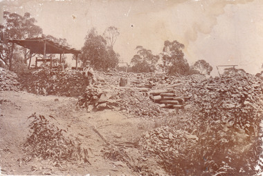 The Beechworth Burke Museum
Photograph
... ...small-scale mining...old...It has potential to improve our understanding of miners working conditions and the shifting character of mining in the Beechworth district. burke museum beechworth museum beechworth gold fields gold rush victorian gold rush gold ming history colonial australia australian gold rushes mining technology beechworth historic district indigo gold trail migration indigo shire good luck gold mine victorian goldfields mining syndicates gold fever quartz-mining small-scale mining old good luck mine mopoke gully quartz reefs beechworth Obverse: Reverse: A02497/ 1997.2497/ 'Good/ Luck/ Mine'/ Morepork/ Gully/ Mrs Joyce/ Bright/ Tunnel/ 800 ft/ 1899. ...This image is a reproduction of an 1899 original depicting the 'Williams Good Luck Mine' on the Mopoke Reef (also called 'Morepork Gully') in the Dingle Ranges, approximately three miles from Beechworth. The foreground of the image is littered with piles of smashed rock and detritus, known as ‘mullock’, beside a reinforced mine shaft, a vertical access passageway allowing miners to enter the mine and haul ore out using lifting technology such as a poppet heads, whims or windlasses. A group of miners and a dog appear close to an open-sided miner’s hut. Following the discovery of gold at Beechworth in 1852, rushes quickly followed at surrounding creeks and gullies in the district. In the late nineteenth and early twentieth centuries, small syndicates of miners continued to work old or abandoned quartz reefs, often persisting without the assistance of heavy machinery to remove the large amounts of rock, in order to obtain yields at ever greater depths. The group of miners in this photograph are Mr. Roger Williams and Sons, who revived operations at the ‘Old Good Luck’ mine on the Mopoke Reef in the Dingle Range near Beechworth around 1892, working the site for more than two decades. An emigrant from Cornwall with experience in the tin mining industry, 19 year old Roger Williams senior sailed to New Zealand in 1840, then to Australia where he spent time in the Bendigo Gold Fields before settling in Beechworth in the early 1860s. Mr Williams senior worked on various mining activities in the district, including the Rocky Mountain Tunnel project. Conversant with the character of gold-bearing reefs in the area, the syndicate dug an eight hundred foot tunnel, digging down as far down as two hundred feet with little capital save their labour, to connect and provide better working access to the mass of reefs and veins in the vicinity. Progress was hampered by poor air quality charged with fumes from dynamite and large quantities of rock had to be crushed to obtain payable yields. The Victorian Goldfields are filled with ruins and remnants of the area's rich mining history, ranging from small alluvial diggings to the remains of huge mining companies. Site names often changed several times throughout the nineteenth and twentieth centuries. Some sites were abandoned and forgotten, others were worked continuously over many decades. The names of mines were often repeated at different locations throughout the Victorian Goldfields. For example, there is a Mopoke Gully heritage mine near Fryers Creek, Victoria. 'Mopoke' is a common onomatopoeic name for Morepork and Australian Boobook owls.This image has historical, social and research significance for patterns of emigration during of the Victorian Gold Rush, and the historical, social and environmental impacts of mining at Beechworth at the turn of the nineteenth and twentieth centuries. As gold became scarce and government support and large company investment waned, poor hard-working miners laboured intensively to make a living through periods of high unemployment. This image can be compared and studied alongside other historical mining photographs and objects in the Burke Museum Collection. It has potential to improve our understanding of miners working conditions and the shifting character of mining in the Beechworth district.Sepia coloured rectangular photograph printed on gloss photographic paper mounted on card.Obverse: Reverse: A02497/ 1997.2497/ 'Good/ Luck/ Mine'/ Morepork/ Gully/ Mrs Joyce/ Bright/ Tunnel/ 800 ft/ 1899. burke museum, beechworth museum, beechworth, gold fields, gold rush, victorian gold rush, gold ming history, colonial australia, australian gold rushes, mining technology, beechworth historic district, indigo gold trail, migration, indigo shire, good luck gold mine, victorian goldfields, mining syndicates, gold fever, quartz-mining, small-scale mining, old good luck mine, mopoke gully, quartz reefs beechworth -
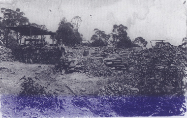 The Beechworth Burke Museum
Photograph - Photograph - Reproduction, Unknown
... ...small-scale mining...old...It has potential to improve our understanding of miners working conditions and the shifting character of mining in the Beechworth district. burke museum beechworth museum beechworth gold fields gold rush victorian gold rush gold ming history colonial australia australian gold rushes mining technology beechworth historic district indigo gold trail migration indigo shire good luck gold mine victorian goldfields mining syndicates gold fever quartz-mining small-scale mining old good luck mine mopoke gully quartz reefs beechworth Obverse: Williams Good Luck Mine Beechworth / Roger! ...This image is a reproduction of an 1899 original depicting the 'Williams Good Luck Mine' on the Mopoke Reef (also called 'Morepork Gully') in the Dingle Ranges, approximately three miles from Beechworth. The foreground of the image is littered with piles of smashed rock and detritus, known as ‘mullock’, beside a reinforced mine shaft, a vertical access passageway allowing miners to enter the mine and haul ore out using lifting technology such as a poppet heads, whims or windlasses. A group of miners and a dog appear close to an open-sided miner’s hut. Following the discovery of gold at Beechworth in 1852, rushes quickly followed at surrounding creeks and gullies in the district. In the late nineteenth and early twentieth centuries, small syndicates of miners continued to work old or abandoned quartz reefs, often persisting without the assistance of heavy machinery to remove the large amounts of rock, in order to obtain yields at ever greater depths. The group of miners in this photograph are Mr. Roger Williams and Sons, who revived operations at the ‘Old Good Luck’ mine on the Mopoke Reef in the Dingle Range near Beechworth around 1892, working the site for more than two decades. An emigrant from Cornwall with experience in the tin mining industry, 19 year old Roger Williams senior sailed to New Zealand in 1840, then to Australia where he spent time in the Bendigo Gold Fields before settling in Beechworth in the early 1860s. Mr Williams senior worked on various mining activities in the district, including the Rocky Mountain Tunnel project. Conversant with the character of gold-bearing reefs in the area, the syndicate dug an eight hundred foot tunnel, digging down as far down as two hundred feet with little capital save their labour, to connect and provide better working access to the mass of reefs and veins in the vicinity. Progress was hampered by poor air quality charged with fumes from dynamite and large quantities of rock had to be crushed to obtain payable yields. The Victorian Goldfields are filled with ruins and remnants of the area's rich mining history, ranging from small alluvial diggings to the remains of huge mining companies. Site names often changed several times throughout the nineteenth and twentieth centuries. Some sites were abandoned and forgotten, others were worked continuously over many decades. The names of mines were often repeated at different locations throughout the Victorian Goldfields. For example, there is a Mopoke Gully heritage mine near Fryers Creek, Victoria. 'Mopoke' is a common onomatopoeic name for Morepork and Australian Boobook owls. This image has historical, social and research significance for patterns of emigration during of the Victorian Gold Rush, and the historical, social and environmental impacts of mining at Beechworth at the turn of the nineteenth and twentieth centuries. As gold became scarce and government support and large company investment waned, poor hard-working miners laboured intensively to make a living through periods of high unemployment. This image can be compared and studied alongside other historical mining photographs and objects in the Burke Museum Collection. It has potential to improve our understanding of miners working conditions and the shifting character of mining in the Beechworth district. Black and white rectangular reproduction photograph printed on matte photographic paper.Obverse: Williams Good Luck Mine Beechworth / Roger! / Reverse: 6858 / burke museum, beechworth museum, beechworth, gold fields, gold rush, victorian gold rush, gold ming history, colonial australia, australian gold rushes, mining technology, beechworth historic district, indigo gold trail, migration, indigo shire, good luck gold mine, victorian goldfields, mining syndicates, gold fever, quartz-mining, small-scale mining, old good luck mine, mopoke gully, quartz reefs beechworth -
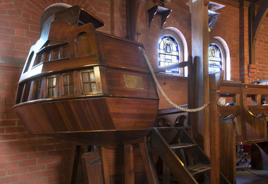 Mission to Seafarers Victoria
Furniture - Pulpit, Rodney Howard Alsop, 1909
... According to a later article published in 1950: The pulpit is a model, built to scale, of the stern of an old ship of the line in Lord Nelson's day. ...According to a later article published in 1950: The pulpit is a model, built to scale, of the stern of an old ship of the line in Lord Nelson's day. ...In 1909, assistant Chaplain Rev. Haire presented the Mission with an 'uncommonly artistic pulpit' in memory of his mother. A plaque in memory of Jane King Haire can be found on the side next to the steps. The dedication was performed by the Archbishop of Melbourne on the 26th January (date engraves on the plaque) This pulpit was designed by Melbourne architect Rodney Howard Alsop (1881-1932) and manufactured by William John Dalziel (furniture manufacturer). It was initially used in the first Mission in Central Melbourne, Siddeley St. It is located in the Chapel of Saint Peter of the Mission to Seafarers 717 Flinders St. complex since 1917 (State Heritage listed (H1496). This complex was designed by Walter Richmond Butler in 1916, and officially opened on 11 September 1917, a day '...of unusually kind weather', by the Governor of Victoria, the Honourable Sir Arthur Stanley. According to a later article published in 1950: The pulpit is a model, built to scale, of the stern of an old ship of the line in Lord Nelson's day. This pulpit is significant as it is housed in The Memorial Chapel of Saint Peter forming part of the State Heritage listed Mission to Seafarers Victoria complex. It was built in Melbourne of Australian timbers, and is one of only two known maritime inspired pulpits, both associated with Missions to Seamen of the early 20th C. the other is held in the ANMM Collection see link. Their statement of significance is worth quoting in part as it applies equally to this pulpit "...an extremely rare and unique example of such pulpits. It is highly significant as a wonderfully preserved example of a time when religion was preached to sailors for their spiritual guidance and temperance..." Rodney Howard Alsop was an important Melbourne architect of the Arts and Crafts movement. John William Dalziel had sailed from Liverpool to Melbourne in 1862. Seventeen years later Penman and Dalziel founded the business in Lonsdale Street West, and won recognition at the Indian and Colonial Exhibition in London in 1886. Penman and Dalziel were identified in 1937 as one of Melbourne’s early ‘skilled craftsmen’ and ‘leading names’ in the manufacture of fine furniture. He died in February 1918 in a railway accident.Timber pulpit built in the form of a ship's stern including a timber step ladder for access, a timber keel and rudder, a rope fixed from the pulpit to a post mounted to the floor, and a dedication plaque on the side of the pulpit. The pulpit sits on timber legs. It's likely to be the original rope: traditionally made coir rope with twisted fibres, covered with canvas supported by a thread. At lower end the rope is secured by a monkey fist know and at the top by a turk head knot.Inside the pulpit (right) is the cardboard label with the maker details: " On an attached plaque see 0678 To the greater glory of God and in ever loving memory of Jane King Haire. This pulpit is erected by her son. Blessed are the pure in heart. For they shall see God. St. Matt. V.8. 26.1.09mission, seafarers, melbourne, victoria, chapel, saint peter, pulpit, australian timber, stern, walter richmond butler, australian maritime history, reverend w.f. haire, rodney howard alsop (1881-1932), wright's lane, william john dalziel, gifts-1917, heritage listed -
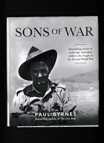 Monbulk RSL Sub Branch
Book, Affirm Press, Sons of war : astonishing stories of under-age Australian soldiers who fought in the Second World War, 2022
... scale of which they could never have imagined. Like many of their fathers in the Great War, they went with their eyes wide shut: under-trained, under-equipped and under-age. Some were as young as thirteen - too young even to shave. Many did not grow old ...In the Second World War, thousands of Australian boys lied about their age and volunteered for a war the scale of which they could never have imagined. Like many of their fathers in the Great War, they went with their eyes wide shut: under-trained, under-equipped and under-age. Some were as young as thirteen - too young even to shave. Many did not grow old; others came back broken. A handful are still alive to tell their tales. This extraordinary book captures the bold and untold stories of forty Australian children who fought in the deadliest war in history. Follow these boys through Libya and Palestine, Greece and Crete, to the jungles of Malaya, Papua New Guinea and Borneo, fighting for their lives, their country, their mates. Many of the photographs have never been seen. Haunting images of youths in training camps and behind the lines stand beside moving portraits of old men who have not forgotten.Index, ill, ,maps, p.380.non-fictionIn the Second World War, thousands of Australian boys lied about their age and volunteered for a war the scale of which they could never have imagined. Like many of their fathers in the Great War, they went with their eyes wide shut: under-trained, under-equipped and under-age. Some were as young as thirteen - too young even to shave. Many did not grow old; others came back broken. A handful are still alive to tell their tales. This extraordinary book captures the bold and untold stories of forty Australian children who fought in the deadliest war in history. Follow these boys through Libya and Palestine, Greece and Crete, to the jungles of Malaya, Papua New Guinea and Borneo, fighting for their lives, their country, their mates. Many of the photographs have never been seen. Haunting images of youths in training camps and behind the lines stand beside moving portraits of old men who have not forgotten.world war 1939-1945 - australia - under age soldiers, world war 1939-1945 - personal narratives - australia -
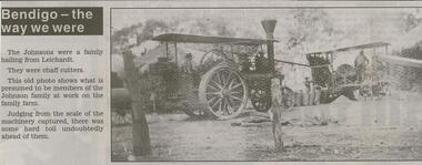 Bendigo Historical Society Inc.
Newspaper - JENNY FOLEY COLLECTION: JOHNSON FAMILY
... This old photo shows what is presumed to be members of the Johnson family at work on the family farm. Judging from the scale of the machinery captured, there was some hard toil undoubtedly ahead of them. ...This old photo shows what is presumed to be members of the Johnson family at work on the family farm. Judging from the scale of the machinery captured, there was some hard toil undoubtedly ahead of them. ...BHS CollectionBendigo Advertiser '' The way we were'' from Wednesday, March 3, 2004. The Johnsons were a family hailing from Leichardt. They were chaff cutters. This old photo shows what is presumed to be members of the Johnson family at work on the family farm. Judging from the scale of the machinery captured, there was some hard toil undoubtedly ahead of them. The clip is in a folder.newspaper, bendigo advertiser, the way we were -
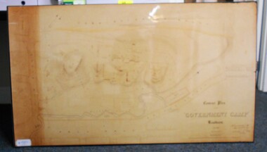 Bendigo Historical Society Inc.
Map - CONTOUR PLAN OF THE GOVERNMENT CAMP SANDHURST 1854, 1994
... Old Cemetery, Garden. Reference on righthand side: 'Stone or brick buildings are tinted in crimson. Wooden buildings tinted in Indian Ink. Tents and other temporary structures tinted in Burnt Sienna.' Scale...Old Cemetery, Garden. Reference on righthand side: 'Stone or brick buildings are tinted in crimson. Wooden buildings tinted in Indian Ink. Tents and other temporary structures tinted in Burnt Sienna.' Scale ...Contour map (copy) of the Government Camp Sandhurst, 1854. Map is mounted on coreflute and laminated. Written in bottom righthand corner 'Contour Plan of the Government Camp, Sandhurst. Dec 1854. Signed by Richard Larritt, Assistant Surveyor, 11th December 1854.' Shown on map: Pall Mall, Bendigo Creek, Commissioner's Gully, View Place (now View Street), Post Office, Bank of Victoria, District Surgeon, Sandhurst Fire Brigade, Police Hospital, Flagstaff, Gold Office, License Shed, Military Barracks, Stables, Commissioner's Buildings, Police Office. Old Cemetery, Garden. Reference on righthand side: 'Stone or brick buildings are tinted in crimson. Wooden buildings tinted in Indian Ink. Tents and other temporary structures tinted in Burnt Sienna.' Scale of Chains, on bottom of map. Sticker on bottom left hand corner and back of map ' Presented by Survey and Mapping, Victoria, 7th Octber, 1994'.map, bendigo, government camp, pall mall, bendigo creek, commissioner's gully, view place (now view street), post office, bank of victoria, district surgeon, sandhurst fire brigade, police hospital, flagstaff, gold office, license shed, military barracks, stables, commissioner's buildings, police office. old cemetery, garden. , survey and mapping victoria. sandhurst, bendigo. -
 Bendigo Historical Society Inc.
Photograph - BILL ASHMAN COLLECTION: FOUR BUOY HOUSE UNIT
... old iron dish which has been used for fowls to drink out of. The photo speaks for it self. After a few weeks treatment by pouring in a dipper full of Scalebuoy Water daily the results of the process can be seen. Note the patches where the scale...old iron dish which has been used for fowls to drink out of. The photo speaks for it self. After a few weeks treatment by pouring in a dipper full of Scalebuoy Water daily the results of the process can be seen. Note the patches where the scale ...Black and white photo by Vincent Kelly. Typed on the back: Four Buoy house unit. Dish in picture is an old iron dish which has been used for fowls to drink out of. The photo speaks for it self. After a few weeks treatment by pouring in a dipper full of Scalebuoy Water daily the results of the process can be seen. Note the patches where the scale formations have been removed. The photographer's name - Vincent Kelly Bendigo is imprinted in the bottom left corner.sciences, instruments - general, scalebuoy, bill ashman collection - correspondence, four buoy house unit, vincent kelly -
 Bendigo Historical Society Inc.
Map - SNOB'S HILL - PLAN OF SNOB'S HILL MINES
... scale of 8 chains to 1 inch. Dams and sand heaps are included. The second page shows x-sections of the poppet legs and their heights. Shaft numbers are included. Two of the pulley diameters are also shown. b. Document headed Caleb Thomas cross sections 10.10.1884. South Catherine, engine east of shaft legs 44 ft high Ellenborough engine east of shaft, legs 40 feet Belmont and Saxby, engine and wheel west of shaft, legs 27 feet York and Durham, engine and wheel west of shaft legs 27 feet Snobs Hill , Old Williams, engine east of shaft legs 53 feet, L. ...scale of 8 chains to 1 inch. Dams and sand heaps are included. The second page shows x-sections of the poppet legs and their heights. Shaft numbers are included. Two of the pulley diameters are also shown. b. Document headed Caleb Thomas cross sections 10.10.1884. South Catherine, engine east of shaft legs 44 ft high Ellenborough engine east of shaft, legs 40 feet Belmont and Saxby, engine and wheel west of shaft, legs 27 feet York and Durham, engine and wheel west of shaft legs 27 feet Snobs Hill , Old Williams, engine east of shaft legs 53 feet, L. ...a. . Handdrawn copy of Snob's Hill Mines by Caleb Thomas (Long Section) 1885. Top drawing show mines and the distance between them. Lower drawing shows leases at a scale of 8 chains to 1 inch. Dams and sand heaps are included. The second page shows x-sections of the poppet legs and their heights. Shaft numbers are included. Two of the pulley diameters are also shown. b. Document headed Caleb Thomas cross sections 10.10.1884. South Catherine, engine east of shaft legs 44 ft high Ellenborough engine east of shaft, legs 40 feet Belmont and Saxby, engine and wheel west of shaft, legs 27 feet York and Durham, engine and wheel west of shaft legs 27 feet Snobs Hill , Old Williams, engine east of shaft legs 53 feet, L. Brace 21ft. 1884 Acadia Catherine engine west. Legs 44 feet, L.brace 11 ft.map, bendigo, goldfields, snob's hill, plan of snob's hill mines, caleb thomas, c reef united, catherine reef shaft, william's main, acadia, william's old main, gt northern, york & durham, snob's hill, belmont & saxby, ellenborough, st mungo, golden pyke, united c'holders, compy, snowdon & co, sth catherine coy, princess alice, saunders, williams & coy, acadia co, wearon & co, snob's hill, nelson trib, kneebone tribute, la belle co, york & durham, north st mungo, saxby & devonshire trib, n? trib, belmont co, durham c'land, kitti trib, sadowa trib, ran?eu co, nth devonshire co, lady barkly, devonshire reef trib, central devonshire co, j c macartney, catherine united -
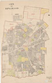 Ringwood and District Historical Society
Map, City of Ringwood - Rateable Properties Layout - c.1966. Overlay showing Reserves, Open Space, Playgrounds, and Schools
... Scale: 8 chains to 1 inch. Map picked up in Engineer's office at old town hall prior to demolition 1971....Ringwood and District Historical Society 125A Warrandyte Road Ringwood North melbourne Scale: 8 chains to 1 inch. Map picked up in Engineer's office at old town hall prior to demolition 1971. ...A0-size (approx) map of named streets, lot-numbered properties and locality features within City of Ringwood boundary. Colour-coded legend identifying Existing Rec Reserves, Proposed Rec Reserves, Existing Open Space, Children's Playgrounds, and Schools.Scale: 8 chains to 1 inch. Map picked up in Engineer's office at old town hall prior to demolition 1971. -
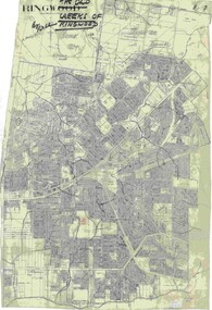 Ringwood and District Historical Society
Map, Old Creeks of Ringwood
... Scale: 8 chains to 1 inch. A0-size (approx) City Engineer's map with hand-drawn overlay highlighting natural water-courses in the Ringwood area, as identified by Rob Atkins, former RDHS President. Other pencilled markings include Perry's Hut, Jull's Store, Crawley's Hut. Old ...A0-size (approx) City Engineer's map with hand-drawn overlay highlighting natural water-courses in the Ringwood area, as identified by Rob Atkins, former RDHS President. Other pencilled markings include Perry's Hut, Jull's Store, Crawley's Hut.Scale: 8 chains to 1 inch. -
 Glenelg Shire Council Cultural Collection
Administrative record - Plans, n.d
... Black and white photocopy of old plan of subdivision, same as 8398, 8399, smaller scale, numerous notations, added by Vanda Savill....Glenelg Shire Council Cultural Collection History House Cliff Street Portland great-ocean-road Black and white photocopy of old plan of subdivision, same as 8398, 8399, smaller scale, numerous notations, added by Vanda Savill. ...Black and white photocopy of old plan of subdivision, same as 8398, 8399, smaller scale, numerous notations, added by Vanda Savill. -
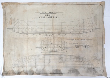 Flagstaff Hill Maritime Museum and Village
Plan - Vessel Line Drawing, Life Boat for Warrnambool, ca. 1900-1909
... It gave a half-century of service to the local community as a lifesaving vessel, including its involvement in retrieving the body of a shipwrecked crew member of the ANTARES. flagstaff hill warrnambool shipwrecked-coast flagstaff-hill flagstaff-hill-maritime-museum maritime-museum shipwreck-coast flagstaff-hill-maritime-village lifeboat warrnambool lifeboat boat plans lifeboat plans boat construction boat building line drawing plan for lifeboat life boat life boat 'Warrnambool' clinker design 1910 lifeboat life saving equipment shipbuilding “LIFE BOAT / FOR / WARRNAMBOOL” “Scale, One Inch to One Foot” “ “Length as shown 30’ – 8” “ “Breadth “ “ 8’ – 6 ½ “ “ “Depth “ “ 3’ – 4 ¾” “ Line drawing in black ink and pencil on rectangular parchment or waxed linen. Drawing has diagrams of three profiles of a vessel, with measurements and connecting pencil lines on the left quarter. The plan is for the lifeboat named “Warrnambool”, which was built in Melbourne and completed in 1910. Old ...The plans were used for the construction of the lifeboat ‘Warrnambool’, which began 15th September 1909 and was completed almost 12 months later 1st September 1910. It was built at the Government Dockyard in Williamstown, Victoria, along the lines designed by Great Britain’s Royal Lifeboat Institution, and included whaleback decks fore and aft, mast and centreboard, and rudder and tiller hung from the sternpost. It could be propelled by both sail and oar. At that time Captain Ferguson was Chief Harbour Master and Mr Beagley was the foreman boat builder. Mr Beagley built the lifeboat with his fellow workmen. The boat was described as “… a fine piece of workmanship and does credit to her builders and designers…” It had all the latest improvements in shape, disposition of weight and watertight compartments, and it had space for a large number of people in addition to the crew. It appears that 'H Meiers' whose signature was on the plaque that was found concealed in the hull, was involved with the building of the lifeboat. His signature and the dates of the start and finish of the boat’s construction are pencilled on the raw timber 'plaque' found in the hull in the early 1990s when the lifeboat was being restored. It is interesting that the ‘Melbourne Directory’ of 1911, published by Sands and MacDougal, lists McAuley and Meiers, boat builders, Nelson Place foreshore, between Pasco and Parker Streets, Williamstown, (Victorian Heritage Database, ‘Contextual History, Maritime Facilities’), It is quite possibly the business of the person whose name is inscribed on the lifeboat plaque. Flagstaff Hill’s documentation also mentions that the keel was laid at ‘Harry Myers, boat builders, Williamstown, Melbourne’ – the name ‘Myers’ can also be spelled ‘Meiers’, which could be the same person as the Meiers in “McAuley and Meiers” (as mentioned in genealogy lines of Myers). The new lifeboat, to be named ‘Warrnambool’ was brought to town by train and launched at the breakwater on 1st March 1911 using the Titan crane (the old lifeboat built in 1858, was then returned to Melbourne in 1911). This new lifeboat was stationed at Warrnambool in a shed located at the base of the Breakwater, adjacent to the slipway. A winch was used to bring it in and out of the water. The lifeboat ‘Warrnambool’ was similar in size to the old lifeboat but far superior in design, build and sea-going qualities such as greater manoeuvrability. The ‘self-righting, self-draining design was “practically non-capsizeable” and even if the boat overturned it would right itself to an even keel and the water would drain away. The hull was built of New Zealand Kauri, using double diagonal planking, laid in two layers at right angles, with a layer of canvas and red lead paint between the timbers to help seal the planking. It has “… plenty of freeboard area, high watertight spaces between the deck and bottom… through which pipes lead…” The backbone timbers were made of Jarrah. The lifeboat Warrnambool was one of several rescue boats used at Port Fairy and Warrnambool in the early 1900s. In late 1914 the Warrnambool lifeboat and crew were used to help find what was left of the tragic wreckage of the Antares and were able to discover the body of one of the crewmen, which they brought back to Warrnambool. Between 1951 and 1954 the lifeboat was manned under the guidance of Captain Carrington. He held lifeboat practice each month on a Sunday morning, to comply with the Ports and Harbour’s request that lifeboats be manned by a strong and competent crew, ready for action in case of emergency. In the early 1960’s it ended its service as a lifeboat and was used in Port Fairy as a barge to help dredge the Moyne River, bolted to the Port Fairy lifeboat. Flagstaff Hill obtained the Warrnambool in 1975. In 1984 it was on display at Flagstaff Hill Maritime Village, Warrnambool. On 23rd May 1990, she was lifted from the water and placed in a cradle for restoration. The name ‘WARRNAMBOOL could be seen faintly on the lifeboat before it was restored. It was during the restoration that Flagstaff Hill's boat builder discovered the 'plaque' inside the hull. A copy of the blueprint plans has the name “V.E.E. Gotch” printed on it. His advertisement in Footscray’s ‘Independent’ newspaper of Saturday 11th May 1901 states he is “Principal and Skilled member (Naval Architect) to the Court of Marine Inquiry of Victoria and holds classes for naval architectural drawing and arithmetic.” The line drawing is significant for its connection with the lifeboat WARRNAMBOOL. The lifeboat is very significant to local and state history for its use in the lifesaving rescues of seafarers, particularly in Lady Bay. It was part of the local rescue equipment. It gave a half-century of service to the local community as a lifesaving vessel, including its involvement in retrieving the body of a shipwrecked crew member of the ANTARES. Line drawing in black ink and pencil on rectangular parchment or waxed linen. Drawing has diagrams of three profiles of a vessel, with measurements and connecting pencil lines on the left quarter. The plan is for the lifeboat named “Warrnambool”, which was built in Melbourne and completed in 1910. Old blue copies of the Lifeboat plan are archived also.“LIFE BOAT / FOR / WARRNAMBOOL” “Scale, One Inch to One Foot” “ “Length as shown 30’ – 8” “ “Breadth “ “ 8’ – 6 ½ “ “ “Depth “ “ 3’ – 4 ¾” “flagstaff hill, warrnambool, shipwrecked-coast, flagstaff-hill, flagstaff-hill-maritime-museum, maritime-museum, shipwreck-coast, flagstaff-hill-maritime-village, lifeboat, warrnambool lifeboat, boat plans, lifeboat plans, boat construction, boat building, line drawing, plan for lifeboat, life boat, life boat 'warrnambool', clinker design, 1910 lifeboat, life saving equipment, shipbuilding