
Showing 68 items matching "phillip miles"
-
 Federation University Historical Collection
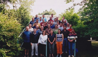
Photograph - Photograph - Colour, VIOSH: Graduate Diploma in Occupational Hazard Management; Intake 27, 2003
... ...phillip miles...VIOSH accepts people into the Graduate Diploma of Occupational Hazard Management who have no undergraduate degree - on the basis of extensive work experience and knowledge. viosh victorian institute of occupational safety and health occupational hazard management mary alvin shayne arthur tracey bence terence bernutt paul brooker joe boras dale brabham jacqueline bryant darryl casey jim coyle gregory creedon wendy dobson leanne edwards james evans paul gentles nicholas giles bethne goudie michael hartshorn peter haynes andrew holmes robert law michael martin david mckelvie gerard mcmillan phillip miles anna mitchell cameron montgomery kenneth nolan robert oliver fred panozzo phillip pennington noel pickering garry pirie rhonda rathjen yasmin saunders jenine smith zorn talevski lenard thomas paul thompson kristi turner patrick weston john whale glenn wiese lisa wild Colour photograph VIOSH: Graduate Diploma in Occupational Hazard Management; Intake 27, 2003 Photograph Photograph - Colour ...Victorian Institute of Occupational Safety and Health (VIOSH) Australia is the Asia-Pacific centre for teaching and research in occupational health and safety (OHS) and is known as one of Australia's leaders in the field. VIOSH has a global reputation for its innovative approach within the field of OHS management. VIOSH had its first intake of students in 1979. At that time the Institution was known as the Ballarat College of Advanced Education. In 1990 it became known as Ballarat University College, then in 1994 as University of Ballarat. It was 2014 that it became Federation University. VIOSH Australia students are safety managers, senior advisors and experienced OHS professionals. They come from all over Australia and industry. Students are taught active research and enquiry; rather than textbook learning and a one-size fits all approach. VIOSH accepts people into the Graduate Diploma of Occupational Hazard Management who have no undergraduate degree - on the basis of extensive work experience and knowledge.Colour photographviosh, victorian institute of occupational safety and health, occupational hazard management, mary alvin, shayne arthur, tracey bence, terence bernutt, paul brooker, joe boras, dale brabham, jacqueline bryant, darryl casey, jim coyle, gregory creedon, wendy dobson, leanne edwards, james evans, paul gentles, nicholas giles, bethne goudie, michael hartshorn, peter haynes, andrew holmes, robert law, michael martin, david mckelvie, gerard mcmillan, phillip miles, anna mitchell, cameron montgomery, kenneth nolan, robert oliver, fred panozzo, phillip pennington, noel pickering, garry pirie, rhonda rathjen, yasmin saunders, jenine smith, zorn talevski, lenard thomas, paul thompson, kristi turner, patrick weston, john whale, glenn wiese, lisa wild -
 Phillip Island and District Historical Society Inc.
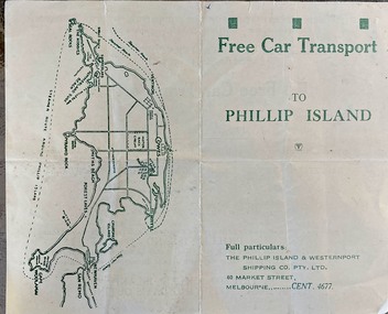
Booklet (item) - Brochure, Free Car Transport to Phillip Island
... Free transport for Sunday returns between Stony Point & Cowes, for winter months of June, July and August. Phillip Island has miles of woodland roads where the friendly Koalas may be seen from the car with the glorious colour effects on a typical winter day with a mild atmosphere and brilliant sunshine. ...Historical Ferries sea transport Tourism Free transport for Sunday returns between Stony Point & Cowes, for winter months of June, July and August. Phillip Island has miles of woodland roads where the friendly Koalas may be seen from the car with the glorious colour effects on a typical winter day with a mild atmosphere and brilliant sunshine. ...The Phillip Island & District Shipping Company was previously owned by Mr Arthur Keaston Sambell who had offerred concessions for travel to locals.HistoricalFree transport for Sunday returns between Stony Point & Cowes, for winter months of June, July and August. Phillip Island has miles of woodland roads where the friendly Koalas may be seen from the car with the glorious colour effects on a typical winter day with a mild atmosphere and brilliant sunshine. ferries, sea transport, tourism -
 Barwon Coast Discovery Centre
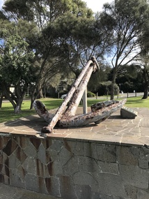
Equipment - Anchor from the Earl of Charlemont
... After a passage of 97 days the ship reached Cape Otway on 17 June and set a course for Port Phillip some 56 miles away. At 5.15 a.m. on the 19 June 1853 the ship struck a reef (later named Charlemont Reef) about 1½ miles from Barwon Heads. ...After a passage of 97 days the ship reached Cape Otway on 17 June and set a course for Port Phillip some 56 miles away. At 5.15 a.m. on the 19 June 1853 the ship struck a reef (later named Charlemont Reef) about 1½ miles from Barwon Heads. ...The Earl of Charlemont was a medium-sized, 878 ton passenger ship built at Saint John, New Brunswick, Canada, in 1849. It sailed from the Port of Liverpool on 13 March 1853 with 366 passengers plus crew, captained by William Gardner. The first port of call was to be Port Phillip, Australia, before continuing to Sydney with the majority of the passengers. After a passage of 97 days the ship reached Cape Otway on 17 June and set a course for Port Phillip some 56 miles away. At 5.15 a.m. on the 19 June 1853 the ship struck a reef (later named Charlemont Reef) about 1½ miles from Barwon Heads. The anchor was raised by Barwon Grove Skin Divers on June 25 1972. Wrought iron anchor -
 Bendigo Historical Society Inc.
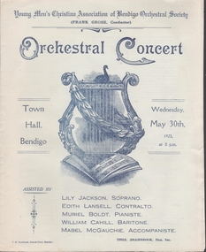
Document - TOWN HALL, YOUNG MEN'S CHRISTIAN ASSOCIATION OF BENDIGO ORCHESTRAL SOCIETY, 30th may, 1923
... J E Fitt, A Richardson, Rex Matthews, Miss Lily Campbell, Elsie Stemmer, Myrtle Phillips, Alma Doxford, Evelyn Miles, Elva Hesse, Winnie Hobson, Master T Challen, J Watts. ...J E Fitt, A Richardson, Rex Matthews, Miss Lily Campbell, Elsie Stemmer, Myrtle Phillips, Alma Doxford, Evelyn Miles, Elva Hesse, Winnie Hobson, Master T Challen, J Watts. ...Town Hall, Young Men's Christian Association of Bendigo Orchestral Society. Orchestral Concert, Town Hall, Bendigo. Wednesday, 30th, 1923, at 8pm. Conductor: Frank Grose. Assisted by: Lily Jackson, Soprano. Edith Lansell, Contralto. Muriel Boldt, Pianiste. William Cahill, Baritone. Mabel McGauchie, Accompaniste. Orchestral Society. Hon. Sec.: Thos. Shambrook. Pirates of Penzance: Romanza Scenza, Arabesque No. 2, Air De Ballet, Death and the Maiden, Sapphic Ode, Let me Love Thee, Russian Boatman Song. William Tell: O love from Thy Pow'r, Scherzo in Bb Minor, Abide with Me, Rock of Ages, Time was I Roved the Mountains, Eyes that used to Gaze in Mine, Invitation Vocal Valse, Coronation march. Bendigo YMCA Orchestral Society. First Violins: Miss Myrtle Knight, Agnes McNair, Olive Hannaford, Winnie Pithie, Louise Bolton, Louise Downie, Ruth Spier, Alison Smalley. Mrs. Grant, Swift. Second Violins: Mr. J E Fitt, A Richardson, Rex Matthews, Miss Lily Campbell, Elsie Stemmer, Myrtle Phillips, Alma Doxford, Evelyn Miles, Elva Hesse, Winnie Hobson, Master T Challen, J Watts. Cellos: Madame Dorothy Duval, Miss Maisie Field, Mr. E Minotti, W Ellis, G L Verey. Basses: Mr. J H Melrose, J Lavacombe, R Rule, W Jackson. Flutes: Mr. A E Sayer, R Crawford, Dilworth, Moon. Piccolo: Mr A E Sayer. Oboe: A B Challen. Clarinets: Mr. A B Challen, J Bowman, J McEwan. Horns: A Johnston, H Hilderbrande, J Tredinnick, L Rundle. , Trumpets: Mr. B Bowater, P Reed, N Banfield, A Old. Trombones: Mr. D Collier, H Bolton, W Pain. Euphonium: W Ketterer. Tubas: Mr. A Hoking, W Ketterer. Sassoon: Mr. T Francis. Timpani: Mr. J McLoughlin. Percussion: Mr. J Osborne. Organist: Mr. F C Stuart. Pianist: Miss Mabel McGauchie. Conductor: Frank Grose. President: Barkly Hyett. Treasurer: G W Lansell. Librarian: W J Wearne. Honorary Secretary: Thos. Shambrook. Three concerts per year will be given by the society. Next two concerts in August and November 1923. Subscribers Tickets are 1 pound 1 shilling. This ticket entitles holder to two booked seats for each concert. Picture of Harp with music book, laurel and bird on cover. 4 pages.F. H. Sparkman, Arcade Press, Bendigo.program, music, town hall, ymca of bendigo orchestral society. orchestral concert -
 Flagstaff Hill Maritime Museum and Village
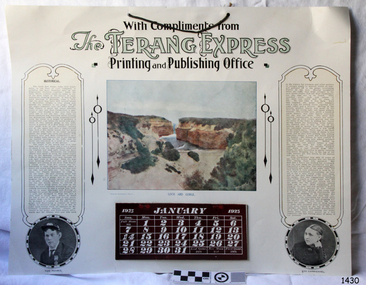
Book - Calendar, T.S. McInnes, The Terang Express: August 1923, 1923
... Phillip was long but uneventful. At 3 am on June 1, 1878, the LOCH ARD was running into a fog that greatly reduced visibility. Captain Gibbs was becoming anxious as there was no sign of land or the Cape Otway lighthouse. The lifteed about an hour later, and the sheer cliffs of Victoria's west coast came into view. Captain Gibbs realised that the ship was much closer to them than expected. Soon after, just half a mile...Phillip was long but uneventful. At 3 am on June 1, 1878, the LOCH ARD was running into a fog that greatly reduced visibility. Captain Gibbs was becoming anxious as there was no sign of land or the Cape Otway lighthouse. The lifteed about an hour later, and the sheer cliffs of Victoria's west coast came into view. Captain Gibbs realised that the ship was much closer to them than expected. Soon after, just half a mile ...The calendar has an account of the event of the wreck of the Loch Ard and the only survivors, Tom Pearce and Eva Carmichael. It was printed by the local firm, The Terang Express. HISTORY OF THE LOCH ARD: - The LOCH ARD belonged to the famous Loch Line, which sailed many ships from England to Australia. Built in Glasgow by Barclay, Curdle and Co. in 1873, the LOCH ARD was a three-masted square-rigged iron sailing ship. The LOCH ARD made three trips to Australia and one trip to Calcutta before its final voyage. LOCH ARD left England on March 2, 1878, under the command of Captain Gibbs, a newly married, 29-year-old, bound for Melbourne with a crew of 37, plus 17 passengers and a load of cargo. There were items included in the cargo that were intended for display in the Melbourne International Exhibition in 1880. The voyage to Port Phillip was long but uneventful. At 3 am on June 1, 1878, the LOCH ARD was running into a fog that greatly reduced visibility. Captain Gibbs was becoming anxious as there was no sign of land or the Cape Otway lighthouse. The lifteed about an hour later, and the sheer cliffs of Victoria's west coast came into view. Captain Gibbs realised that the ship was much closer to them than expected. Soon after, just half a mile from the coast, the ship's bow was suddenly pulled around by the anchor. The captain tried to tack out to sea, but the ship struck a reef at the base of Mutton Bird Island, near Port Campbell. Waves broke over the ship, and the top deck was loosened from the hull. The masts and rigging came crashing down, knocking passengers and crew overboard. When a lifeboat was finally launched, it crashed into the side of LOCH ARD and capsized. Tom Pearce drifted out to sea and then, on the flood tide, came into what is now known as LOCH ARD Gorge. He swam to shore, bruised and dazed, and found a cave in which to shelter. Eva Carmichael had raced onto the deck to find out what was happening, only to be confronted by towering cliffs looming above the stricken ship. In all the chaos, she was swept into the sea. Eva saw Tom Pearce on a small rocky beach and yelled to attract his attention. He dived in and swam to the exhausted woman and dragged her to shore. He took her to the cave and broke open a case of brandy which had washed up on the beach. He opened a bottle to revive the unconscious woman. Later, Tom scaled a cliff in search of help. He eventually came by chance upon two men from nearby Glenample Station. Eventually, the two shipwreck survivors were taken to Glenample Station to recover. Eva stayed at the station for six weeks before returning to Ireland, this time by steamship. Of the 54 crew members and passengers on board, only two survived: the apprentice, Tom Pearce and the young woman passenger, Eva Carmichael, who lost all of her family in the tragedy.The calendar records the wreck of the Loch Ard, showing that the event was significant locally and thought worthy of publishing on a local calendar. The calendar is significant for its connection to the wreck of the Loch Flagstaff Hill’s collection of artefacts from LOCH ARD is significant for being one of the largest collections of artefacts from this shipwreck in Victoria. It is significant for its association with the shipwreck, which is on the Victorian Heritage Register (VHR S417). The collection is significant because of the relationship between the objects, as together they have a high potential to interpret the story of the LOCH ARD. The LOCH ARD collection is archaeologically significant as the remains of a large international passenger and cargo ship. The LOCH ARD collection is historically significant for representing aspects of Victoria’s shipping history and its potential to interpret sub-theme 1.5 of Victoria’s Framework of Historical Themes (living with natural processes). The collection is also historically significant for its association with the LOCH ARD, which was one of the worst and best known shipwrecks in Victoria’s history.Calendar printed by Terang Express for August 1923 with a Coloured picture of Loch Ard Gorge and portraits of the survivors of the wreck, Tom Pearce and Eva Carmichael, and a brief story of the episode of the wreck. There is a piece of string for hanging the calendar on a wall."With Compliments from The Terang Express Printing and Publishing Office" "December1923" "Historical" "Tom Pearce" "Eva Carmichael"flagstaff hill, warrnambool, shipwrecked coast, flagstaff hill maritime museum, maritime museum, shipwreck coast, flagstaff hill maritime village, great ocean road, loch line, loch ard, captain gibbs, eva carmichael, tom pearce, glenample station, mutton bird island, terang express, calendar, 1923, calendar 1923, printer, newspaper, loch ard gorge, 50th anniversary, flagstaff hill maritime museum and village, maritime village, august 1923 -
 Flagstaff Hill Maritime Museum and Village
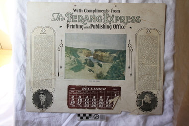
Book - Calendar, Terang Express, The Terang Express: December 1923, 1923
... Phillip was long but uneventful. At 3 am on June 1, 1878, the LOCH ARD was running into a fog that greatly reduced visibility. Captain Gibbs was becoming anxious as there was no sign of land or the Cape Otway lighthouse. The lifteed about an hour later, and the sheer cliffs of Victoria's west coast came into view. Captain Gibbs realised that the ship was much closer to them than expected. Soon after, just half a mile...Phillip was long but uneventful. At 3 am on June 1, 1878, the LOCH ARD was running into a fog that greatly reduced visibility. Captain Gibbs was becoming anxious as there was no sign of land or the Cape Otway lighthouse. The lifteed about an hour later, and the sheer cliffs of Victoria's west coast came into view. Captain Gibbs realised that the ship was much closer to them than expected. Soon after, just half a mile ...The calendar has an account of the event of the wreck of the Loch Ard and the only survivors, Tom Pearce and Eva Carmichael. It was printed by the local firm, The Terang Express. HISTORY OF THE LOCH ARD: - The LOCH ARD belonged to the famous Loch Line, which sailed many ships from England to Australia. Built in Glasgow by Barclay, Curdle and Co. in 1873, the LOCH ARD was a three-masted square-rigged iron sailing ship. The LOCH ARD made three trips to Australia and one trip to Calcutta before its final voyage. LOCH ARD left England on March 2, 1878, under the command of Captain Gibbs, a newly married, 29-year-old, bound for Melbourne with a crew of 37, plus 17 passengers and a load of cargo. There were items included in the cargo that were intended for display in the Melbourne International Exhibition in 1880. The voyage to Port Phillip was long but uneventful. At 3 am on June 1, 1878, the LOCH ARD was running into a fog that greatly reduced visibility. Captain Gibbs was becoming anxious as there was no sign of land or the Cape Otway lighthouse. The lifteed about an hour later, and the sheer cliffs of Victoria's west coast came into view. Captain Gibbs realised that the ship was much closer to them than expected. Soon after, just half a mile from the coast, the ship's bow was suddenly pulled around by the anchor. The captain tried to tack out to sea, but the ship struck a reef at the base of Mutton Bird Island, near Port Campbell. Waves broke over the ship, and the top deck was loosened from the hull. The masts and rigging came crashing down, knocking passengers and crew overboard. When a lifeboat was finally launched, it crashed into the side of LOCH ARD and capsized. Tom Pearce drifted out to sea and then, on the flood tide, came into what is now known as LOCH ARD Gorge. He swam to shore, bruised and dazed, and found a cave in which to shelter. Eva Carmichael had raced onto the deck to find out what was happening, only to be confronted by towering cliffs looming above the stricken ship. In all the chaos, she was swept into the sea. Eva saw Tom Pearce on a small rocky beach and yelled to attract his attention. He dived in and swam to the exhausted woman and dragged her to shore. He took her to the cave and broke open a case of brandy which had washed up on the beach. He opened a bottle to revive the unconscious woman. Later, Tom scaled a cliff in search of help. He eventually came by chance upon two men from nearby Glenample Station. Eventually, the two shipwreck survivors were taken to Glenample Station to recover. Eva stayed at the station for six weeks before returning to Ireland, this time by steamship. Of the 54 crew members and passengers on board, only two survived: the apprentice, Tom Pearce and the young woman passenger, Eva Carmichael, who lost all of her family in the tragedy.The calendar records the wreck of the Loch Ard, showing that the event was significant locally and thought worthy of publishing on a local calendar. The calendar is significant for its connection to the wreck of the Loch Flagstaff Hill’s collection of artefacts from LOCH ARD is significant for being one of the largest collections of artefacts from this shipwreck in Victoria. It is significant for its association with the shipwreck, which is on the Victorian Heritage Register (VHR S417). The collection is significant because of the relationship between the objects, as together they have a high potential to interpret the story of the LOCH ARD. The LOCH ARD collection is archaeologically significant as the remains of a large international passenger and cargo ship. The LOCH ARD collection is historically significant for representing aspects of Victoria’s shipping history and its potential to interpret sub-theme 1.5 of Victoria’s Framework of Historical Themes (living with natural processes). The collection is also historically significant for its association with the LOCH ARD, which was one of the worst and best known shipwrecks in Victoria’s history. Calendar printed by Terang Express for December 1923 with a Coloured picture of Loch Ard Gorge and portraits of the survivors of the wreck, Tom Pearce and Eva Carmichael, and a brief story of the episode of the wreck. "With Compliments from The Terang Express Printing and Publishing Office" "December1923" "Historical" "Tom Pearce" "Eva Carmichael"flagstaff hill, warrnambool, shipwrecked coast, flagstaff hill maritime museum, maritime museum, shipwreck coast, flagstaff hill maritime village, great ocean road, loch line, loch ard, captain gibbs, eva carmichael, tom pearce, glenample station, mutton bird island, loch ard gorge, calendar, terang express, 1923, 50th anniversary, flagstaff hill maritime museum and village, maritime village, august 1923 -
 Greensborough Historical Society
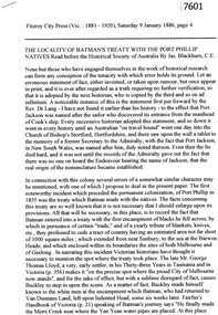
Article - Newspaper Clipping (copy), Jas Blackburn, The locality of Batman's Treaty with the Port Phillip natives, 09/01/1886
... Discusses Batman's Treaty with the Port Phillip traditional owners and the possible site of the signing - on the east side of the River Plenty, NW of Eltham andd 3 miles above the junction of the Plenty with the Yarra River....Discusses Batman's Treaty with the Port Phillip traditional owners and the possible site of the signing - on the east side of the River Plenty, NW of Eltham andd 3 miles above the junction of the Plenty with the Yarra River. john batman batman's treaty port phillip district plenty river 6p. text. ...Text of a paper read before the Historical Society of Australia by Jas. Blackburn in 1886. Discusses Batman's Treaty with the Port Phillip traditional owners and the possible site of the signing - on the east side of the River Plenty, NW of Eltham andd 3 miles above the junction of the Plenty with the Yarra River.6p. text.john batman, batman's treaty, port phillip district, plenty river -
 City of Moorabbin Historical Society (Operating the Box Cottage Museum)
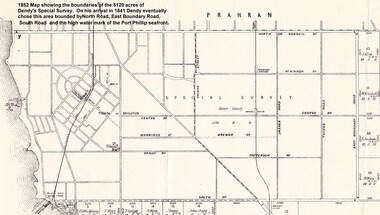
Photograph - Map of Dendy's Special Survey, 1852 Map of Henry Dendy's Special Survey of 1841, 19th Century
... Together, Dendy and Were decided on an area 5 miles south from Melbourne, bounded by North Road, East Boundary Road, South Road and to the west by Port Phillip Bay. ...Henry Dendy & Jonathan Were chose an area 5 miles south from Melbourne, bounded by North Road, East Boundary Road, South Road and to the west by Port Phillip Bay. ...Together, Dendy and Were decided on an area 5 miles south from Melbourne, bounded by North Road, East Boundary Road, South Road and to the west by Port Phillip Bay. ...A Map drawn in 1852 that shows the 5,120 acres that formed Dendy's Special Survey of 1841. In 1840 Henry Dendy, a farmer in Surrey, England acquired a "Special Survey" from the Commissioners for Land and Emigration which gave Dendy the right to choose land in Port Phillip for the "bargain basement" price of only £1 per acre for 5120 acres, (an area of 8 square miles). The Special Survey also included the right to "the shipment of a worker for every £20 spent on land, whose free passage was paid by the Crown, equalling a total of 100 workers ". Accordingly Dendy sold his English holdings and paid the required £5120 and arrived in Melbourne in February 1841. However by this time land in the new colony was selling for £5 - £40 per acre. Because Henry Dendy possessed the order from the Colonial Office in London he was able to successfully oppose Governor LaTrobe's attempts to alter the price of the land. Dendy appointed Jonathan Were, (an entrepreneur, who had arrived in 1839), as his Manager and who later became a partner. Together, Dendy and Were decided on an area 5 miles south from Melbourne, bounded by North Road, East Boundary Road, South Road and to the west by Port Phillip Bay. Were and Dendy pitched their tents in the area now known as ' Park St, Brighton' and sank a well near the corner of 'St Andrew's St and Wells St'. By 1845 J.B Were and Company had bought almost half of Dendy's land and Were built himself "Moorabbin House" in Were St Brighton made from stone, quarried from local cliffs. It was still standing in 1924. Legend records Moorabbin is named after the Aboriginal word for ' Mother's Milk ' The soil is very fertile and well supplied with water especially in the area called 'East Brighton' - now known as Bentleigh and East Bentleigh - By 1850 the area had developed with numerous market gardens, dairy farms, fruit gardens and vineyards supplying food for the growing population of Melbourne.This Map shows the birth of the Brighton and Moorabbin area. On 18th January1859 Brighton was proclaimed a Municipality and a Borough by October 1863. Meanwhile, following a Petition, the area of East and South Brighton, incorporating Mordialloc, Cheltenham, Mentone, Sandringham and Oakleigh separated from Brighton to form the Moorabbin District Roads Board becoming the first Local Government Authority. Col. William Mair was elected as the first Chairman of the Moorabbin Roads Board. Moorabbin Shire 1871 developed further and was declared a City in1934. The City of Moorabbin was the largest Municipality in Melbourne before the Amalgamation of Councils in 1994 when it was divided in the south to City of Kingston and in the north to City of Glen Eira A Photo-lithographed 1852 Map showing the 5,120 acres that formed Dendy's Special Survey of 1841. Henry Dendy & Jonathan Were chose an area 5 miles south from Melbourne, bounded by North Road, East Boundary Road, South Road and to the west by Port Phillip Bay. Moorabbin County of Bourke / Photo-Lithographed at the department of Lands and Survey. /Melbourne. / Price 1/- brighton, moorabbin, bentleigh, cheltenham, dendy henry, bent thomas, were jonathan, special survey -
 Orbost & District Historical Society
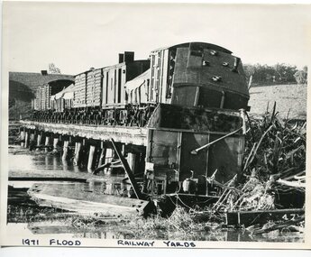
black and white photograph, February 1971
... Phillips. (see orbosthistory.com.au) The railway line was destroyed and was not expected to be opened for a fortnight. Orbost was cut off by 50 square miles...Phillips. (see orbosthistory.com.au) The railway line was destroyed and was not expected to be opened for a fortnight. Orbost was cut off by 50 square miles ...The 1971 flood was the the worst flood on record. At Jarrahmond it was at least 11 metres and up to one and a half kilometres wide on the flats causing enormous damage to the flood plain. Records say that "The brown floodwater stain in Bass Strait could be seen from passing airliners." Considerable damage was done to railway infrastructure, roads and farms. More information from the APRIL, 2008 newsletter by John Phillips. (see orbosthistory.com.au) The railway line was destroyed and was not expected to be opened for a fortnight. Orbost was cut off by 50 square miles of Snowy River floodwater. This train was being shunted across the viaduct when waters smashed through washing away several trucks sending the crew running for their lives.This is pictorial evidence of a significant local event. It is connected to the history of the railway in East Gippsland.A large black / white photograph of flooded railway yards with a train engine stranded on a small section of track surrounded by water and debris.on front - "1971 Flood, Railway Yards"floods-1971-orbost orbost-railway natural-disasters-orbost -
 Orbost & District Historical Society
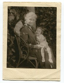
black and white photograph, first half 20th century
... miles in pony and jinker. Wairewa State School, No. 3739 was built in 1923. The school closed at the end of 1973. Mrs Trevaskis was the teacher at Wairewa 1919-22 and 1945-1956. ( more information in News letter No. 123 NOVEMBER, 2015 - John Phillips)...miles in pony and jinker. Wairewa State School, No. 3739 was built in 1923. The school closed at the end of 1973. Mrs Trevaskis was the teacher at Wairewa 1919-22 and 1945-1956. ( more information in News letter No. 123 NOVEMBER, 2015 - John Phillips) This item is associated with the history of education in East Gippsland. educatio-east-gippsland wairewa-state-school trevaskis-eveline inside cover - "Teacher at Wairewa" A black / white photograph in a small cream coloured folio. ...The lady in this photograph is probably Mrs Eveline Trevaskis who taught at the Wairewa School. Mrs. Trevaskis taught school from her early 20’s in different parts of Victoria. She gave it up to get married, has four children and 11 grand-children. Four of her grand-children are at Wairewa school. Mrs. Trevaskis went back to teaching during the wartime teacher shortage. She relieved at Buchan East State School for two years, getting up at 3.45 am to drive the 24 miles in pony and jinker. Wairewa State School, No. 3739 was built in 1923. The school closed at the end of 1973. Mrs Trevaskis was the teacher at Wairewa 1919-22 and 1945-1956. ( more information in News letter No. 123 NOVEMBER, 2015 - John Phillips)This item is associated with the history of education in East Gippsland.A black / white photograph in a small cream coloured folio. It is of an older lady seated on a chair with a young child on her lap. The child is laughing.inside cover - "Teacher at Wairewa"educatio-east-gippsland wairewa-state-school trevaskis-eveline -
 Orbost & District Historical Society
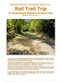
Booklet - Rail Trail Trip, John Phillips, The Newmerella Blasting Accident Site, Tuesday 15th October, 2024, 2025
... miles west of Orbost. John and Peter Carroll and John Sullivan 13th of March 1914 died in this accident. railway blasting accident 1914 railway construction deaths Carroll Sullivan Orbost & District Historical Society Inc RAIL TRAIL TRIP To Newmerella Blasting Accident Site Tuesday 15th October, 2024 11 page plastic covered booklet. The cover page has a large coloured photograph of a trail through bushland. The writing on the cover is in orange print. The Newmerella Blasting Accident Site, Tuesday 15th October, 2024 Booklet Rail Trail Trip John Phillips ...This booklet records the trip made by members of the Orbost and District Historical Society (including Heather Terrell, Roy Hofen and Eddie Slatter) on 15 October 2024 to view sites associated with the 1914 blasting accident site at Newmerella. Others attending were Noreen Thomson, May Leatch, Gaye Pearson, Lois Crisp, Heather Terrel, John Philips and Geoff Stevenson. This blasting accident which killed three workers occurred during construction of the Bairnsdale - Orbost railway line. It involved two men, a father and son from the same family (John and Peter Carroll) and another worker John Sullivan, all of whom died. It was the worst accident to occur during construction of this railway. This booklet is significant because it records details of the site where the deaths of three men working on the railway construction at Newmerella occurred, located about two miles west of Orbost. John and Peter Carroll and John Sullivan 13th of March 1914 died in this accident. 11 page plastic covered booklet. The cover page has a large coloured photograph of a trail through bushland. The writing on the cover is in orange print. Orbost & District Historical Society Inc RAIL TRAIL TRIP To Newmerella Blasting Accident Site Tuesday 15th October, 2024railway blasting accident 1914, railway construction deaths, carroll, sullivan -
 Orbost & District Historical Society
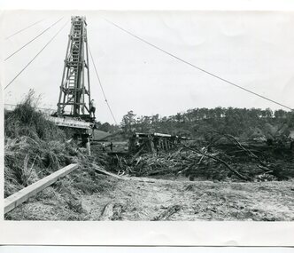
black and white photographs, 15th February 1971
... Phillips. (see orbosthistory.com.au) The railway line was destroyed and was not expected to be opened for a fortnight. Orbost was cut off by 50 square miles...Phillips. (see orbosthistory.com.au) The railway line was destroyed and was not expected to be opened for a fortnight. Orbost was cut off by 50 square miles ...The 1971 flood was the the worst flood on record. At Jarrahmond it was at least 11 metres and up to one and a half kilometres wide on the flats causing enormous damage to the flood plain. Records say that "The brown floodwater stain in Bass Strait could be seen from passing airliners." Considerable damage was done to railway infrastructure, roads and farms. More information from the APRIL, 2008 newsletter by John Phillips. (see orbosthistory.com.au) The railway line was destroyed and was not expected to be opened for a fortnight. Orbost was cut off by 50 square miles of Snowy River floodwater. These photographs are pictorial records of the 1971 floods which was a significant event in the history of Orbost. They are also associated with the East Gippsland Railway.Three black / white photographs of flood debris and flood waters near a railway line. 3102.l has a pile driver 3102.2 shows a gap in the viaduct and 3102.3 shows men with a tractor cleaning up the debris,3102.1 - on back - "1971 FLOOD REPAIRS TO ORBOST RAILWAY VIADUCT - 15th February 1971. Donated by Audrey Van Den Berg VRH 3693" 3102.2 - on back - " DAMAGE TO RAILWAY VIADUCT ACCUMULATED DEBRIS" 3102.3 - on back - "DAMAGE TO RAILWAY VIADUCT AT ORBOST. CLEAN UP BEGINS"orbost-flood-1971 orbost-viaduct-flood-damage orbost-railway -
 Ringwood and District Historical Society
Photograph, Ringwood State School - Grade 5A, 1975
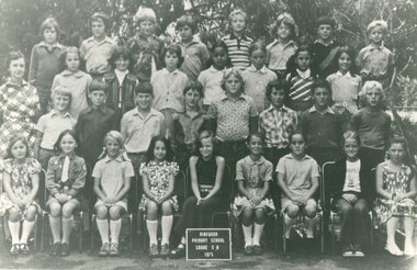
... "Attached to photograph" Back Row- L to R: Ian Butterworth, David Miller, Ken Baynkhin, Robert Miles, Robert de Keame, Lindsay Dawe, Dante Cellante, Steven Crashaw. 2nd Row- L to R: Jane Woolhouse, Susan Carlton, Bernadette O'Connor, Marie Roses, Erie Law, Connie Nicolopoulos, Joanne Chapman. 3rd Row- L to R: Wayne Bonney, Andrew Roper, Ricky Jenkinson, Phillip Elliot, Michael Beard, Darren Kane, Leslie Tomada, Garry Mathieson. ..."Attached to photograph" Back Row- L to R: Ian Butterworth, David Miller, Ken Baynkhin, Robert Miles, Robert de Keame, Lindsay Dawe, Dante Cellante, Steven Crashaw. 2nd Row- L to R: Jane Woolhouse, Susan Carlton, Bernadette O'Connor, Marie Roses, Erie Law, Connie Nicolopoulos, Joanne Chapman. 3rd Row- L to R: Wayne Bonney, Andrew Roper, Ricky Jenkinson, Phillip Elliot, Michael Beard, Darren Kane, Leslie Tomada, Garry Mathieson. ...Black and white photograph - Grade 5A, 1975."Attached to photograph" Back Row- L to R: Ian Butterworth, David Miller, Ken Baynkhin, Robert Miles, Robert de Keame, Lindsay Dawe, Dante Cellante, Steven Crashaw. 2nd Row- L to R: Jane Woolhouse, Susan Carlton, Bernadette O'Connor, Marie Roses, Erie Law, Connie Nicolopoulos, Joanne Chapman. 3rd Row- L to R: Wayne Bonney, Andrew Roper, Ricky Jenkinson, Phillip Elliot, Michael Beard, Darren Kane, Leslie Tomada, Garry Mathieson. Front Row- L to R: Mandy Faye, Lee Logan, Kerryn Oxley, Francesco Grico, Leanne Clark, Pauline Tobias, Lindy Toomey, Sheridan Oates, Michelle Webb. Teacher: Isobel Marshall -
 City of Moorabbin Historical Society (Operating the Box Cottage Museum)
Document - Genealogy Chart Henry Dendy (Photocopy), 19 thC
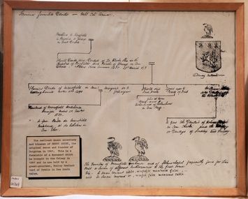
... Together, Dendy and Were decided on an area 5 miles south from Melbourne, bounded by North Road, East Boundary Road, South Road and to the west by Port Phillip Bay. ...Together, Dendy and Were decided on an area 5 miles south from Melbourne, bounded by North Road, East Boundary Road, South Road and to the west by Port Phillip Bay. ...In 1840 Henry Dendy, a farmer in Surrey, England acquired a "Special Survey" from the Commissioners for Land and Emigration which gave Dendy the right to choose land in Port Phillip for the "bargain basement" price of only £1 per acre for 5120 acres, (an area of 8 square miles). The Special Survey also included the right to "the shipment of a worker for every £20 spent on land, whose free passage was paid by the Crown, equalling a total of 100 workers ". Accordingly Dendy sold his English holdings and paid the required £5120 and arrived in Melbourne in February 1841. However by this time land in the new colony was selling for £5 - £40 per acre. Because Henry Dendy possessed the order from the Colonial Office in London he was able to successfully oppose Super-intendant LaTrobe's attempts to alter the price of the land. Dendy appointed Jonathan Were, (an entrepreneur, who had arrived in 1839), as his Manager and who later became a partner. Together, Dendy and Were decided on an area 5 miles south from Melbourne, bounded by North Road, East Boundary Road, South Road and to the west by Port Phillip Bay. Were and Dendy pitched their tents in the area now known as ' Park St, Brighton' and sank a well near the corner of 'St Andrew's St and Wells St'. By 1845 J.B Were and Company had bought almost half of Dendy's land and Were built himself "Moorabbin House" in Were St Brighton made from stone, quarried from local cliffs. It was still standing in 1924. Legend records Moorabbin is named after the Aboriginal word for ' Mother's Milk ' The soil is very fertile and well supplied with water especially in the area called 'East Brighton' - now known as Bentleigh and East Bentleigh - By 1850 the area had developed with numerous market gardens, dairy farms, fruit gardens and vineyards supplying food for the growing population of Melbourne.In 1840 Henry Dendy, a farmer in Surrey, England acquired a "Special Survey" from the Commissioners for Land and Emigration which gave Dendy the right to choose land in Port Phillip for the price of only £1 per acre for 5120 acres. This land was called Brighton in the Parish of Moorabbin, County of Bourke and emigrants developed the land establishing market gardens , dairy and poultry farms that provided the food for the growing population of Melbourne. A photocopy of the Genealogy Chart of the Dendy Family that Henry Dendy brought with him when he emigrated to Melbourne 1841Genealogy signs and descriptionsdendy henry, dendy's special survey brighton 1841, governor gipps, captain lonsdale, super-intendant latrobe, port phillip, melbourne, new south wales, squatters, emmigrants, county of bourke, parish of moorabbin, early settlers, pioneers, market gardeners, dairy farmers, fruit farms, moorabbin, bentleigh, brighton, cheltenham, were jonathan binn, -
 City of Moorabbin Historical Society (Operating the Box Cottage Museum)
Document, Henry Dendy family Shield
... Together, Dendy and Were decided on an area 5 miles south from Melbourne, bounded by North Road, East Boundary Road, South Road and to the west by Port Phillip Bay. ...Together, Dendy and Were decided on an area 5 miles south from Melbourne, bounded by North Road, East Boundary Road, South Road and to the west by Port Phillip Bay. ...In 1840 Henry Dendy, a farmer in Surrey, England acquired a "Special Survey" from the Commissioners for Land and Emigration which gave Dendy the right to choose land in Port Phillip for the "bargain basement" price of only £1 per acre for 5120 acres, (an area of 8 square miles). The Special Survey also included the right to "the shipment of a worker for every £20 spent on land, whose free passage was paid by the Crown, equalling a total of 100 workers ". Accordingly Dendy sold his English holdings and paid the required £5120 and arrived in Melbourne in February 1841. However by this time land in the new colony was selling for £5 - £40 per acre. Because Henry Dendy possessed the order from the Colonial Office in London he was able to successfully oppose Super-intendant LaTrobe's attempts to alter the price of the land. Dendy appointed Jonathan Were, (an entrepreneur, who had arrived in 1839), as his Manager and who later became a partner. Together, Dendy and Were decided on an area 5 miles south from Melbourne, bounded by North Road, East Boundary Road, South Road and to the west by Port Phillip Bay. Were and Dendy pitched their tents in the area now known as ' Park St, Brighton' and sank a well near the corner of 'St Andrew's St and Wells St'. By 1845 J.B Were and Company had bought almost half of Dendy's land and Were built himself "Moorabbin House" in Were St Brighton made from stone, quarried from local cliffs. It was still standing in 1924. Legend records Moorabbin is named after the Aboriginal word for ' Mother's Milk ' The soil is very fertile and well supplied with water especially in the area called 'East Brighton' - now known as Bentleigh and East Bentleigh - By 1850 the area had developed with numerous market gardens, dairy farms, fruit gardens and vineyards supplying food for the growing population of Melbourne. dendy henry, dendy's special survey brighton 1841, governor gipps, captain lonsdale, super-intendant latrobe, port phillip, melbourne, new south wales, squatters, emmigrants, county of bourke, parish of moorabbin, early settlers, pioneers, market gardeners, dairy farmers, fruit farms, moorabbin, bentleigh, brighton, cheltenham, were jonathan binn, -
 City of Moorabbin Historical Society (Operating the Box Cottage Museum)
Document - Pedigree of Henry Dendy, c1840 Original ; Copy 1985
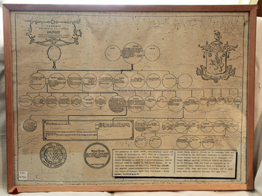
... Together, Dendy and Were decided on an area 5 miles south from Melbourne, bounded by North Road, East Boundary Road, South Road and to the west by Port Phillip Bay. ...Together, Dendy and Were decided on an area 5 miles south from Melbourne, bounded by North Road, East Boundary Road, South Road and to the west by Port Phillip Bay. ...This is a copy of the document brought by Henry Dendy to the Colony in 1841. In 1840 Henry Dendy, a farmer in Surrey, England acquired a "Special Survey" from the Commissioners for Land and Emigration which gave Dendy the right to choose land in Port Phillip for the "bargain basement" price of only £1 per acre for 5120 acres, (an area of 8 square miles). The Special Survey also included the right to "the shipment of a worker for every £20 spent on land, whose free passage was paid by the Crown, equalling a total of 100 workers ". Accordingly Dendy sold his English holdings and paid the required £5120 and arrived in Melbourne in February 1841. However by this time land in the new colony was selling for £5 - £40 per acre. Because Henry Dendy possessed the order from the Colonial Office in London he was able to successfully oppose Super-intendant LaTrobe's attempts to alter the price of the land. Dendy appointed Jonathan Were, (an entrepreneur, who had arrived in 1839), as his Manager and who later became a partner. Together, Dendy and Were decided on an area 5 miles south from Melbourne, bounded by North Road, East Boundary Road, South Road and to the west by Port Phillip Bay. Were and Dendy pitched their tents in the area now known as ' Park St, Brighton' and sank a well near the corner of 'St Andrew's St and Wells St'. By 1845 J.B Were and Company had bought almost half of Dendy's land and Were built himself "Moorabbin House" in Were St Brighton made from stone, quarried from local cliffs. It was still standing in 1924. Legend records Moorabbin is named after the Aboriginal word for ' Mother's Milk ' The soil is very fertile and well supplied with water especially in the area called 'East Brighton' - now known as Bentleigh and East Bentleigh - By 1850 the area had developed with numerous market gardens, dairy farms, fruit gardens and vineyards supplying food for the growing population of Melbourne. A copy of a paper chart of the Pedigree of Henry Dendy in a wooden frame with glassPedigree / of the branch of the family / DENDY moorabbin, brighton, henry dend special survey 1841 y, early settlers, pioneers, market gardeners -
 Phillip Island and District Historical Society Inc.
Photograph, 1950 approx
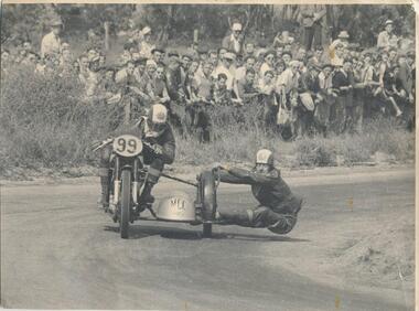
... Racing first came to Phillip Island in 1927 in the form of a 200 mile road race for motorcycles on a circuit encompassing Cowes and Rhyll. ...Racing first came to Phillip Island in 1927 in the form of a 200 mile road race for motorcycles on a circuit encompassing Cowes and Rhyll. ...Donated by J W Gliddon with his comments on back of photograph. Taken when motorbike and car racing were run around the roads on Phillip Island. Racing first came to Phillip Island in 1927 in the form of a 200 mile road race for motorcycles on a circuit encompassing Cowes and Rhyll. In the next year, a shorter rectangular course, again on public roads, was used for the running of what became the first Australian Grand Prix. Eight successive Australian Grand Prix were run on this course before the race was moved elsewhere. Finally in 1935, racing was discontinued and Phillip Island lapsed into the tranquility and peacefulness of its quiet country and beach atmosphere.Black & White photograph of motorcycle riders on bike and sidecar. Crowd watching at the side of the road. See Historical Information for more detail re motorcycle racing on Phillip Island.On back: "This picture could become historically interesting as machines and methods change. It was taken about the year 1950. Perhaps earlier." motor cycle racing -
 Phillip Island and District Historical Society Inc.
Photographs, Early 20th Century
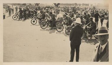
... Six black & white photographs taken on Phillip Island. 365-01: Waiting for start of 100 mile event on Phillip Island for Motor Cycle Race. 365-02: Lined up for start of the 50 mile Grand Prix Race on Phillip Island. 365-03: Start of the 50 mile event. 365-04: Approaching Cowes Pier, Phillip Island. 365-05: The Nobbies, Phillip Island. 365-06: View near The Nobbies with waves breaking over the rocks....Lined up for start of 50 mile. 365-03: Start of 50 mile event. 365-04: Approaching Cowes 365-05: The Nobbies Phillip Island. 365-06: View near The Nobbies Phillip Island....Six black & white photographs taken on Phillip Island. 365-01: Waiting for start of 100 mile event on Phillip Island for Motor Cycle Race. 365-02: Lined up for start of the 50 mile Grand Prix Race on Phillip Island. 365-03: Start of the 50 mile event. 365-04: Approaching Cowes Pier, Phillip Island. 365-05: The Nobbies, Phillip Island. 365-06: View near The Nobbies with waves breaking over the rocks. ...A collection of six photographs donated by John Jansson. The first Grand Prix motorbike and car races were held on a course around the roads of Phillip Island.Six black & white photographs taken on Phillip Island. 365-01: Waiting for start of 100 mile event on Phillip Island for Motor Cycle Race. 365-02: Lined up for start of the 50 mile Grand Prix Race on Phillip Island. 365-03: Start of the 50 mile event. 365-04: Approaching Cowes Pier, Phillip Island. 365-05: The Nobbies, Phillip Island. 365-06: View near The Nobbies with waves breaking over the rocks.365-01: ACUV Races P.I. Waiting for start of 100 mile 365-02: Grand Prix Races. Lined up for start of 50 mile. 365-03: Start of 50 mile event. 365-04: Approaching Cowes 365-05: The Nobbies Phillip Island. 365-06: View near The Nobbies Phillip Island.motorbike racing on phillip island, the nobbies phillip island, cowes pier phillip island, john jansson -
 Phillip Island and District Historical Society Inc.
Photograph - Post Card, 1919
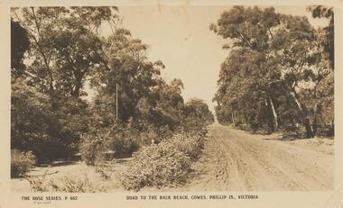
... "The Rose Series, P. 662" "Road to the Back Beach, Cowes, Phillip Is., Victoria". On Back: "This road 1 mile from Cowes" Letter: "Dear Marie, Wishing you many happy returns and the best of good wishes with much love. ...Donated by Stan McFee from the Keith McIlwraith Collection. road to back beach, cowes phillip island stan mcfee keith mcilwraith collection "The Rose Series, P. 662" "Road to the Back Beach, Cowes, Phillip Is., Victoria". On Back: "This road 1 mile from Cowes" Letter: "Dear Marie, Wishing you many happy returns and the best of good wishes with much love. ...Donated by Stan McFee from the Keith McIlwraith Collection.Black & White Postcard of an unmade road to the Back Beach, Cowes. Road edged with trees and bushes."The Rose Series, P. 662" "Road to the Back Beach, Cowes, Phillip Is., Victoria". On Back: "This road 1 mile from Cowes" Letter: "Dear Marie, Wishing you many happy returns and the best of good wishes with much love. From all at "Heath Hill".road to back beach, cowes, phillip island, stan mcfee, keith mcilwraith collection -
Phillip Island and District Historical Society Inc.
School Bell, 1872
... On a calm day it could be heard at Rhyll 5 miles (8 kms) away. local history equipment school bell cowes phillip island Cowes State School Iron or Bronze Bell painted black with suspension frame. ...Cowes State School No. 1282 was situated where Museum & Civic Buildings now stand in Thompson Avenue. School was built in 1872 by Mr. R. Blaikie and helpers. Opened officially 12th October 1874. First bell of original school. On a calm day it could be heard at Rhyll 5 miles (8 kms) away.Iron or Bronze Bell painted black with suspension frame.local history, equipment, school bell, cowes, phillip island, cowes state school -
 Phillip Island and District Historical Society Inc.
Photograph, 1935
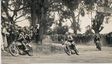
... One of a collection of over 400 photographs in an album commenced in 1960 and presented to the Phillip Island & Westernport Historical Society by the Shire of Phillip Island The race in this photograph was the Australian Junior Tourist Trophy race over 75 miles/12 laps. ...One of a collection of over 400 photographs in an album commenced in 1960 and presented to the Phillip Island & Westernport Historical Society by the Shire of Phillip Island The race in this photograph was the Australian Junior Tourist Trophy race over 75 miles/12 laps. ...One of a collection of over 400 photographs in an album commenced in 1960 and presented to the Phillip Island & Westernport Historical Society by the Shire of Phillip Island The race in this photograph was the Australian Junior Tourist Trophy race over 75 miles/12 laps. The winner, Cec Weatherby received 20 pounds prize money and a sash. The race was run concurrectly with the Lightweight race, which was common back then. Peter Shannon's brother has the actual bike that came 3rd in that 1935 Lightweight race.Photograph of C. Weatherby leading other Motor Cyclists rounding "Tin Pot Corner" in a Motor Cycle Race in 1935. Corrections to the above given by Peter Shannon 2/11/2018. No. 11 was Don Bain actually leading the group, who came 3rd, No. 64 was Cec Weatherby who won the race and No. 25 was Ron Walters who came 4th. The Flyer was also given to us by Peter Shannon.local history, photography, motor cycle race, black & white photograph, sport, motor cycle racing, "tin pot corner", c weatherby, john jenner, bryant west -
 Phillip Island and District Historical Society Inc.
Photograph
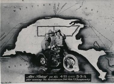
... One of a collection of over 400 photographs in an album commenced in 1960 and presented to the Phillip Island & Westernport Historical Society by the Shire of Phillip Island local history photography souvenir phillip island's first motor cycle race black & white photograph phillip island race track motor cycle racing alex findlay John Jenner Bryant West Alex Findlay on his 4.93 OHV B.S.A. after winning the Australasian 200 mile TT Championship Photograph of Alex Findlay on his motor cycle superimposed on a map of Phillip Island Photograph Bryant West ...One of a collection of over 400 photographs in an album commenced in 1960 and presented to the Phillip Island & Westernport Historical Society by the Shire of Phillip IslandPhotograph of Alex Findlay on his motor cycle superimposed on a map of Phillip IslandAlex Findlay on his 4.93 OHV B.S.A. after winning the Australasian 200 mile TT Championshiplocal history, photography, souvenir, phillip island's first motor cycle race, black & white photograph, phillip island race track, motor cycle racing, alex findlay, john jenner, bryant west -
 Flagstaff Hill Maritime Museum and Village
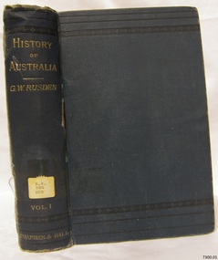
Book - Reference Book/History/Social History, George William Rusden, History of Australia Vol 1, 1883
... In 1849, he became agent for National Schools in Port Phillip (later Victoria) and Moreton Bay, travelling over 10,000 miles by horse to promote state directed education despite his Anglican faith. ...In 1849, he became agent for National Schools in Port Phillip (later Victoria) and Moreton Bay, travelling over 10,000 miles by horse to promote state directed education despite his Anglican faith. ...Volume 1 covers Australia's history from prehistoric times through early European exploration to the founding of New South Wales in 1788. It details early rumours of a great southern land. Also voyages by explorers like Dirk Hartog, Tasman, Dampier, and Cook, along with the establishment of the first colony under Governor Arthur Phillip, including challenges like famine and initial settlements.History of Australia Vol 1 Author: George William Rusden Publisher: Chapman & Hall Ltd Date: 1883non-fictionVolume 1 covers Australia's history from prehistoric times through early European exploration to the founding of New South Wales in 1788. It details early rumours of a great southern land. Also voyages by explorers like Dirk Hartog, Tasman, Dampier, and Cook, along with the establishment of the first colony under Governor Arthur Phillip, including challenges like famine and initial settlements. warrnambool, shipwrecked-coast, flagstaff-hill, flagstaff-hill-maritime-museum, maritime-museum, shipwreck-coast, flagstaff-hill-maritime-village, shipwrecked-artefact, great ocean road, book, warrnambool library, warrnambool mechanics’ institute, mechanics’ institute library, victorian library board, warrnambool books and records, warrnambool children’s library, warrnambool public library, history of australia vol 1, g w rusden -
 Flagstaff Hill Maritime Museum and Village
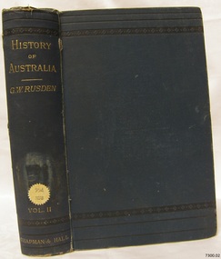
Book - Reference Book/History/Social History, George William Rusden, History of Australia Vol 2, 1883
... In 1849, he became agent for National Schools in Port Phillip (later Victoria) and Moreton Bay, travelling over 10,000 miles by horse to promote state directed education despite his Anglican faith. ...In 1849, he became agent for National Schools in Port Phillip (later Victoria) and Moreton Bay, travelling over 10,000 miles by horse to promote state directed education despite his Anglican faith. ...Volume 2 of G.W. Rusden's History of Australia continues the narrative from early colonial governance, examining governors after Arthur Phillip up through the mid 19th century. It covers expansions in New South Wales, the establishment of Van Diemen's Land (Tasmania), and Moreton Bay (Queensland), including key events like the Macarthur wool industry rise, convict management under governors like Lachlan Macquarie, and inter colonial tensions.Hard cover book History of Australia in three Volumes Author: George William Rusden Publisher: Chapman & Hall Ltd London, Melbourne and Sydney Date: 1883 Dark blue hardcover with a blue matching spine, the spine has a label with an inscription. (These volumes are first editions)non-fictionVolume 2 of G.W. Rusden's History of Australia continues the narrative from early colonial governance, examining governors after Arthur Phillip up through the mid 19th century. It covers expansions in New South Wales, the establishment of Van Diemen's Land (Tasmania), and Moreton Bay (Queensland), including key events like the Macarthur wool industry rise, convict management under governors like Lachlan Macquarie, and inter colonial tensions.warrnambool, shipwrecked-coast, flagstaff-hill, flagstaff-hill-maritime-museum, maritime-museum, shipwreck-coast, flagstaff-hill-maritime-village, shipwrecked-artefact, great ocean road, book, warrnambool library, warrnambool mechanics’ institute, mechanics’ institute library, victorian library board, warrnambool books and records, warrnambool children’s library, warrnambool public library, history of australia vol 2, g w rusden -
 Flagstaff Hill Maritime Museum and Village
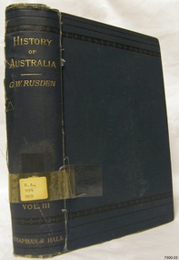
Book - Reference Book/History/Social History, George William Rusden, History of Australia Vol 3, 1883
... In 1849, he became agent for National Schools in Port Phillip (later Victoria) and Moreton Bay, travelling over 10,000 miles by horse to promote state directed education despite his Anglican faith. ...In 1849, he became agent for National Schools in Port Phillip (later Victoria) and Moreton Bay, travelling over 10,000 miles by horse to promote state directed education despite his Anglican faith. ...Volume 3 shifts to political developments, focusing on the 1856 Constitution Act and Victoria's road to self-government. It details federation debates, relationships with Britain, sketches later governors, and addresses gold rush impacts, land reforms, and emerging parliamentary systems across colonies. Together, the volumes form Rusden's comprehensive, if biased, chronicle to the 1850s.Hard cover book History of Australia in three Volumes Author: George William Rusden Publisher: Chapman & Hall Ltd London, Melbourne and Sydney Date: 1883 Dark blue hardcover with a blue matching spine, the spine has a label with an inscription. (These volumes are first editions)non-fictionVolume 3 shifts to political developments, focusing on the 1856 Constitution Act and Victoria's road to self-government. It details federation debates, relationships with Britain, sketches later governors, and addresses gold rush impacts, land reforms, and emerging parliamentary systems across colonies. Together, the volumes form Rusden's comprehensive, if biased, chronicle to the 1850s.warrnambool, shipwrecked-coast, flagstaff-hill, flagstaff-hill-maritime-museum, maritime-museum, shipwreck-coast, flagstaff-hill-maritime-village, book, warrnambool library, warrnambool mechanics’ institute, mechanics’ institute library, victorian library board, warrnambool books and records, warrnambool children’s library, warrnambool public library, history of australia vol 3, g w rusden -
 Phillip Island and District Historical Society Inc.
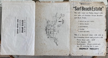
Booklet, Surf Beach Estate, About 1950
... " Surf Beach Estate" '"The only estate on Phillip island with two miles of Glorious Ocean Beaches and Rock Pools." ...Davie was a local real estate agent Historical Surf Beach real estate W Davie town planning " Surf Beach Estate" '"The only estate on Phillip island with two miles of Glorious Ocean Beaches and Rock Pools." ...W. Davie was a local real estate agentHistoricalBooklet advertising the Surf Beach Estate . Large sheet printed on both sides. One side has map of the estate. other has information about estate, agent and location on Island" Surf Beach Estate" '"The only estate on Phillip island with two miles of Glorious Ocean Beaches and Rock Pools." Prices from only 250 pound.surf beach, real estate, w davie, town planning -
 Phillip Island and District Historical Society Inc.
Newspaper Clipping, Pipe Laying, Jan 1968
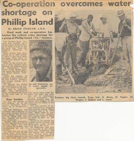
... Collection of newspaper clippins from a Scrap book 1960 - 1973 Drought Relief on Phillip Island Pipe line on Phillip Island Newspaper clipping Jean Jamieson Article on the laying of 12 miles of pipe to tap the main line from the Candowie Reservoir to farmers, a quarry and Len Lukey's Racing Circuit. ...Collection of newspaper clippins from a Scrap book 1960 - 1973Article on the laying of 12 miles of pipe to tap the main line from the Candowie Reservoir to farmers, a quarry and Len Lukey's Racing Circuit.drought relief on phillip island, pipe line on phillip island, newspaper clipping, jean jamieson -
 Phillip Island and District Historical Society Inc.
Photograph Album, Kodak, Phillip Island Cemetery, c 1990
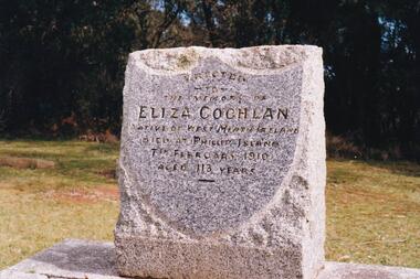
... She came to Phillip Island as house-keeper to James Duffus and served for 40 years. She was often seen walking to Cowes, about five miles, carrying a heavy turkey. ...She came to Phillip Island as house-keeper to James Duffus and served for 40 years. She was often seen walking to Cowes, about five miles, carrying a heavy turkey. ...The Album was compiled by Nancy McHaffie late 1990's, with the assistance of Edith Jeffery's, with her book "Garden of Memories" and extensive knowledge of Phillip Island. The Cemetery lies back from the road and is surrounded by Manna Gums, rare Peppermint Gums, Blackwoods and other native trees. In all 25 acres of land were set aside as Crown Land in the land settlement of 1868. There are 6.2 acres of wetlands near the cemetery entrance.a) Grave stone of Eliza Coghlan b) Grave stone of Eliza Coghlan with Edith Jeffery standing beside. Eliza was born in West Heath, Ireland. She arrived in Australia on the immigrant ship "Thomas Arbuthnot". She came to Phillip Island as house-keeper to James Duffus and served for 40 years. She was often seen walking to Cowes, about five miles, carrying a heavy turkey. The main road to the cemetery was named in her honour. It has been claimed that Eliza with the oldest subject of Queen Victoria. She died in February 1910, at the age of 113.phillip island cemetery, nancy mchaffie, edith jeffery -
 Phillip Island and District Historical Society Inc.
Badge, Badge - Phillip Island Advances Cowes Regatta
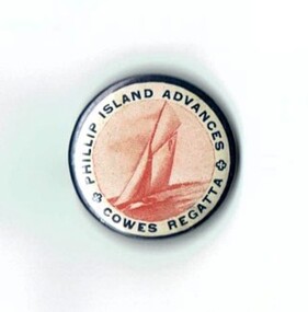
... mile yacht race was held off Cowes. It was won by J. Walton on the Mayflower. Historical yacht race J. Walton Sampbell Kennon Grayden Phillip Island Advances Cowes Regatta Small round metal badge with white background. ...In March 1935, to celebrate the centenary of Melbourne, a 12 mile yacht race was held off Cowes. It was won by J. Walton on the Mayflower.HistoricalSmall round metal badge with white background. Dark writing around edge and drawing in red of a yacht sailing in centre. Pin on back.Phillip Island Advances Cowes Regattayacht race, j. walton, sampbell, kennon, grayden -
 Ringwood and District Historical Society
Photograph - Group, Ringwood Technical School 1963 Form 1C
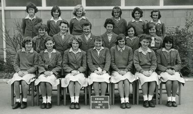
... Names: Top row: Lorraine Gibbs, Elaine Gration, Anita Smith, Patricia O’Dea, Ann McGregor, Sandra Diprose. 2nd row: Sandra Thomas, Robyn Jensen, Therese Birchall, Gail Phillips, Judith Flarherty, Joan ?. 1st row: Jeanette Miles, Judith Cruickshank, Yvonne Aston, Susan Marsden, Heidi Henkel, Rosemary D’Orival Margaret Piergrosse....The school was known locally as Ringwood Tech School, Ringwood Tech, Ringy Tech, Ringers, The Tech and RTS. rts ringwood tech Names: Top row: Lorraine Gibbs, Elaine Gration, Anita Smith, Patricia O’Dea, Ann McGregor, Sandra Diprose. 2nd row: Sandra Thomas, Robyn Jensen, Therese Birchall, Gail Phillips, Judith Flarherty, Joan ?. 1st row: Jeanette Miles, Judith Cruickshank, Yvonne Aston, Susan Marsden, Heidi Henkel, Rosemary D’Orival Margaret Piergrosse. ...This Form was part of the largest intake to date as Ringwood Technical School entered its fourth year at the Heathmont Road campus. The 269 Form 1 students in 12 groups, 1A to 1M, took the school’s population to nearly 700. Extensions to the 3 year old building commenced during the year to help accommodate the expected rising numbers of students. The school was known locally as Ringwood Tech School, Ringwood Tech, Ringy Tech, Ringers, The Tech and RTS.Black and White Photograph Photograph from Ringwood Technical School photo album labelled “Ringwood Technical School 1963-’64 Class Photos” (VC 21255)Names: Top row: Lorraine Gibbs, Elaine Gration, Anita Smith, Patricia O’Dea, Ann McGregor, Sandra Diprose. 2nd row: Sandra Thomas, Robyn Jensen, Therese Birchall, Gail Phillips, Judith Flarherty, Joan ?. 1st row: Jeanette Miles, Judith Cruickshank, Yvonne Aston, Susan Marsden, Heidi Henkel, Rosemary D’Orival Margaret Piergrosse.rts, ringwood tech
