Showing 826 items matching "settlers park"
-
 Marysville & District Historical Society
THE TRIANGLE NEWS-VOL 37 NO 43-NOVEMBER 19 2010
... ...settlers park...Marysville & District Historical Society 39 Darwin Street Marysville yarra-valley-and-the-dandenong-ranges marysville victoria australia melbourne ballet company settlers park THE TRIANGLE NEWS-VOL 37 NO 43-NOVEMBER 19 2010 ...marysville, victoria, australia, melbourne ballet company, settlers park -
 Warrnambool and District Historical Society Inc.
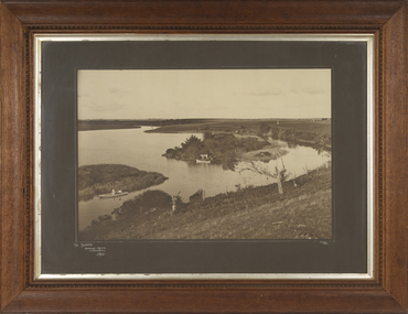
Photograph - Framed Photograph of the Islands in the Hopkins River, Jordan Studios, Warrnambool, 1911
... Park). It was, and still is, a picnic and fishing spot. On one of the islands is an unmarked grave which may be that of Jemima Christine Allan, the first wife of one of the first European settlers in the Allansford area, William Allan. ...Park). It was, and still is, a picnic and fishing spot. On one of the islands is an unmarked grave which may be that of Jemima Christine Allan, the first wife of one of the first European settlers in the Allansford area, William Allan. ...This photograph shows the islands in the Hopkins River in 1911. This section of the river is in the Allansford area, near Jubilee Park (Hopkins River Caravan Park). It was, and still is, a picnic and fishing spot. On one of the islands is an unmarked grave which may be that of Jemima Christine Allan, the first wife of one of the first European settlers in the Allansford area, William Allan. She died in 1842. The photograph was taken by Jordan Studios so the photographer may be either Joseph Jordan, one of the best-known Warrnambool photographers of the past, or his son Arthur, also a well-credentialled photographer.This photograph is considerable historical importance, showing a section of the Hopkins River in the Warrnambool region in 1911.This is a black and white photograph in a wooden frame with a patterned edging. The photograph is inset with a gilt metal edging and enclosed in glass. The backing is wooden with a wire cord for hanging. The photograph shows the river with islands covered in vegetation. On the river are two boats, one wuih four occupants standing up in the boat and the other with two occupants. In the ccntre of the photograph is a tree stump and a dead tree.The Islands Hopkins River Warrnambool 1911 Jordan Photohopkins river, jemima allan, jordan studios -
 Warrnambool and District Historical Society Inc.
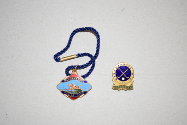
Badges (2), 1 Stokes, 1960s
... settlers in Warrnambool. The badges appear to have belonged to Agnes Ardlie who was known to have been a keen sportswoman. The Warrnambool Racing Club was founded in the 1870s and annually produced badges for members, both men and women. Female membership of the Warrnambool Golf Club was well established by 1890 and the course then was in Albert Park...settlers in Warrnambool. The badges appear to have belonged to Agnes Ardlie who was known to have been a keen sportswoman. The Warrnambool Racing Club was founded in the 1870s and annually produced badges for members, both men and women. Female membership of the Warrnambool Golf Club was well established by 1890 and the course then was in Albert Park ...These two badges came from the estate of Dorothy and Agnes Ardlie of Warrnambool. Dorothy Ardlie (1910-1993) and Agnes Ardlie (1915-1993) were the daughters of Arthur and Ethel Ardlie of Warrnambool, the granddaughters of the prominent Warrnambool lawyer, William Ardlie and his wife Mary and the great granddaughters of John and Mary Ardlie, pioneer settlers in Warrnambool. The badges appear to have belonged to Agnes Ardlie who was known to have been a keen sportswoman. The Warrnambool Racing Club was founded in the 1870s and annually produced badges for members, both men and women. Female membership of the Warrnambool Golf Club was well established by 1890 and the course then was in Albert Park. These two badges are of interest as having local provenance, belonging to a member or members of a prominent family in Warrnambool in the mid 20th century..1 This is a metal badge in an elliptical shape with gold edging. The image on the badge shows a horse and jockey clearing a hurdle with wording around the image. The colours used are blue, red, gold and green. The badge has a metal clip at the top with a blue cord attached. The back of the badge has wording imprinted on it. .2 This is an oval-shaped metal badge with an image of two golf clubs in blue and gold and the word ‘Associates’ in gold and green. On the back is a metal clip and some hand writing scratched on. The maker’s name cannot be deciphered. .1 Warrnambool Racing Club Not Transferable Season 1965-66 9 Stokes .2 Warrnambool G.C. Associates Ardlie A.A. ardlie family, history of warrnambool -
 Warrnambool and District Historical Society Inc.
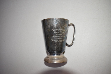
Golf Club Trophy, 1950
... settlers in Warrnambool. The trophy was won by Agnes Ardlie in 1950. The Warrnambool Golf Club was established in the late 19th century and the game was played by both men and women at Albert Park until 1929 when it shifted to its present day course in what was once part of the old Western Reserve. ...settlers in Warrnambool. The trophy was won by Agnes Ardlie in 1950. The Warrnambool Golf Club was established in the late 19th century and the game was played by both men and women at Albert Park until 1929 when it shifted to its present day course in what was once part of the old Western Reserve. ...This item comes from the estate of Dorothy and Agnes Ardlie of Warrnambool. Dorothy Ardlie (1910-1993) and Agnes Ardlie (1915-1993) were the daughters of Arthur and Ethel Ardlie of Warrnambool, the granddaughters of the prominent Warrnambool lawyer, William Ardlie and his wife Mary and the great granddaughters of John and Mary Ardlie, pioneer settlers in Warrnambool. The trophy was won by Agnes Ardlie in 1950. The Warrnambool Golf Club was established in the late 19th century and the game was played by both men and women at Albert Park until 1929 when it shifted to its present day course in what was once part of the old Western Reserve. This trophy is of interest as a mid 20th century memento of a member of a prominent family in Warrnambool, Miss Agnes Ardlie and of the Warrnambool Golf Club.This is an electro-plated nickel silver mug with a circular base, a tapering body and a handle. It is much stained. There is an inscription on one side of the mug and a maker’s name on the base but this is not decipherable. Warrnambool Golf Club ‘B’ Grade Scratch Event 1950 Miss A.M. Ardlieardlie family, history of warrnambool -
 Warrnambool and District Historical Society Inc.
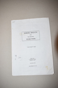
Booklet, Samuel Baulch and the Original Rose Park
... This booklet contains the first draft of an article on Samuel Baulch’s acquisition of his property, Rose Park which was in the Macarthur/Hawkesdale district. Samuel Baulch’s parents, Francis and Ann Baulch were pioneer settlers in the Kirkstall area and Samuel worked at the Dunmore Station in the Macarthur area before purchasing the property he named Rose Park in the early 1870s. ...Warrnambool and District Historical Society Inc. 2 Gilles Street (south of Merri St) Warrnambool great-ocean-road This booklet contains the first draft of an article on Samuel Baulch’s acquisition of his property, Rose Park which was in the Macarthur/Hawkesdale district. Samuel Baulch’s parents, Francis and Ann Baulch were pioneer settlers in the Kirkstall area and Samuel worked at the Dunmore Station in the Macarthur area before purchasing the property he named Rose Park in the early 1870s. ...This booklet contains the first draft of an article on Samuel Baulch’s acquisition of his property, Rose Park which was in the Macarthur/Hawkesdale district. Samuel Baulch’s parents, Francis and Ann Baulch were pioneer settlers in the Kirkstall area and Samuel worked at the Dunmore Station in the Macarthur area before purchasing the property he named Rose Park in the early 1870s. In the 1890s he acquired property in the Dunmore Estate. Samuel’s son, Stan Baulch, acquired sections of the Dunmore property after his father’s death and he named his section, Rose Park, a property to the west of the original Rose Park. This article is of historical interest and will be useful to researchers of local and family history. This is a booklet of 18 pages. It has a paper cover and the pages were originally stapled together but now have a plastic clip. The booklet has been home-produced and the material typed on a computer. Some of the pages are a little stained. samuel baulch, rose park, western victoria, history of warrnambool -
 Warrnambool and District Historical Society Inc.
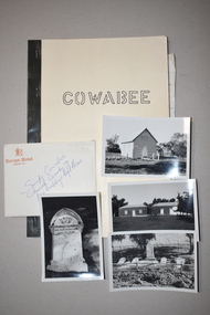
Booklet with Photographs, Stan Baulch, Cowabee, 1978 (booklet)
... In the 1870s Samuel Baulch, the son of pioneer Kirkstall settlers, Francis and Ann Baulch, established a property in the Macarthur/Hawkesdale area called Rose Park. ...In the 1870s Samuel Baulch, the son of pioneer Kirkstall settlers, Francis and Ann Baulch, established a property in the Macarthur/Hawkesdale area called Rose Park. ...These items concern the history of the Baulch family ownership of Cowabee, a large grazing property in the Riverina in N.S.W. In the 1870s Samuel Baulch, the son of pioneer Kirkstall settlers, Francis and Ann Baulch, established a property in the Macarthur/Hawkesdale area called Rose Park. In 1893 he acquired Dunmore, a nearby property, and Rose Park became part of that estate. In 1910 Samuel Baulch purchased Cowabee in N.S.W. and Stan Baulch, the son of Samuel and Eliza, later managed Cowabee for some years. After Samuel’s death Stan Baulch and his two brothers split up Dunmore and Stan acquired the eastern third which he named Rose Park. Cowabee was sold in 1922. This booklet and associated material is of some historical interest as a summary of the history of Cowabee, one of the properties owned by the Baulch family of the Western District in the early 20th century. It will be of some use to researchers, with the photographs an added bonus. .1 This is a booklet of 41 pages with a buff-coloured paper cover with a black tape binding. The front cover has a title in hand-printed lettering and the back cover has a red stamp (partly obliterated). The booklet contains typed information on Cowabee Station. .2 This is a small envelope containing six black and white photographs, all with handwritten information on the back. .21 & .22 These are two loose sheets of writing pad paper with handwriting in blue ink. .1 Cowabee .2 Snaps Cowabee Church Cemetry(sic) & pise buildings left there cowabee station, n.s.w., baulch family western district victoria, history of warrnambool -
 Warrnambool and District Historical Society Inc.
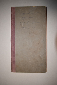
Journal, Baulch, Early 20th century
... settlers, Francis and Ann Baulch and the son of Samuel and Eliza Baulch. In 1893 Samuel Baulch acquired the historic property of Dunmore, between Macarthur and Hawkesdale and in 1910 he purchased the property of Cowabee in the Riverina district in N.S.W. Stan Baulch managed Cowabee for some years before inheriting part of Dunmore which he named Rose Park...settlers, Francis and Ann Baulch and the son of Samuel and Eliza Baulch. In 1893 Samuel Baulch acquired the historic property of Dunmore, between Macarthur and Hawkesdale and in 1910 he purchased the property of Cowabee in the Riverina district in N.S.W. Stan Baulch managed Cowabee for some years before inheriting part of Dunmore which he named Rose Park ...This ledger’s first owner was Rolf Crawley, an architect and the official engineer for the Shire of Warrnambool from 1935 to 1968. His grandfather, father and uncle also worked for the Shire of Warrnambool, with the family members recording a total of 132 years of service to the Shire. Stan Baulch later acquired the ledger, tore out the pages that had been used and recorded some aspects of his life from 1916 to 1923. Stanley Baulch (1897-1980) was the grandson of pioneer Kirkstall settlers, Francis and Ann Baulch and the son of Samuel and Eliza Baulch. In 1893 Samuel Baulch acquired the historic property of Dunmore, between Macarthur and Hawkesdale and in 1910 he purchased the property of Cowabee in the Riverina district in N.S.W. Stan Baulch managed Cowabee for some years before inheriting part of Dunmore which he named Rose Park. Cowabee was sold in 1922. Although only a few pages in length, this diary contains much interesting information on the early years of Stan Baulch at the homesteads of Cowabee and Dunmore. It will be useful for research purposes.This is a hard cover ledger with a dark grey cover and dark red binding. It contains pages printed with the name and address of the Shire of Warrnambool Engineer, Rolf Crawley. These pages contain two sections to a page ruled with blue lines to be used for short letters or invoices (originally 500 sections). The ledger also has blank pink pages used for duplicate copies. The first 42 sections have been torn out. Twenty of the pages have handwritten material in blue ink and these are biographical notes about the years 1916 to 1923 written in the ledger at a later date by Stan Baulch.Cowabee-Dunmore S.S.B. diaries 1916-23stanley baulch, cowabee & dunmore properties, rolf crawley, history of warrnambool -
 Warrnambool and District Historical Society Inc.
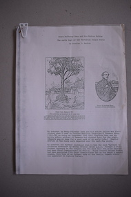
Article, Henry Pulteney Dana and his Native Police, 1970s
... settlers in the Kirkstall area in the 1840s. Stan’s father, Samuel Baulch, established a property in the Macarthur/Hawkesdale area in the 1870s (Rose Park) and in 1893 bought the nearby property of Dunmore which had been established in the 1840s by Charles Hamilton MacKnight and partners. ...settlers in the Kirkstall area in the 1840s. Stan’s father, Samuel Baulch, established a property in the Macarthur/Hawkesdale area in the 1870s (Rose Park) and in 1893 bought the nearby property of Dunmore which had been established in the 1840s by Charles Hamilton MacKnight and partners. ...This item is a copy of an article on Henry Dana and the Native Police of the 1840s and 50s in Victoria. Henry Dana’s police corps is regarded as the forerunner of today’s Victorian Police Force. The article was written by Stan Baulch when he was a member of the Warrnambool and District Historical Society, probably in the 1970s. The paternal grandparents of Stanley Samuel Baulch (1897-1980) were Francis and Ann Baulch, pioneer settlers in the Kirkstall area in the 1840s. Stan’s father, Samuel Baulch, established a property in the Macarthur/Hawkesdale area in the 1870s (Rose Park) and in 1893 bought the nearby property of Dunmore which had been established in the 1840s by Charles Hamilton MacKnight and partners. (It was when Stan Baulch was reading the 19th century diary of Charles MacKnight that he first came across the story of Henry Dana and the native police). Stan Baulch inherited part of the Dunmore estate on his father’s death and this he named Rose Park, using his father’s property’s name. Stan Baulch had a great interest in local history and as well as the article on Henry Dana he also produced a booklet on early bullocking and bullock-drivers in the Western District. This article is a copy so does not have any strong historical significance but another copy of it will be a useful file item in the collection of the Warrnambool and District Historical Society.This is an article of 8 foolscap pages, with the material in it being a typed copy. The first page has two photocopied illustrations. stanley baulch, rose park, western district,, victoria, history of warrnambool -
 Warrnambool and District Historical Society Inc.
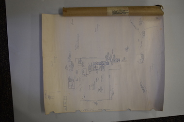
Document (Sketch Plan of Dunmore), Stan Baulch, 1972
... Francis and Ann Baulch were pioneer settlers in the Kirkstall area and their son Samuel worked at Dunmore in the Macarthur area before purchasing in the early 1870s the property he named Rose Park. ...Francis and Ann Baulch were pioneer settlers in the Kirkstall area and their son Samuel worked at Dunmore in the Macarthur area before purchasing in the early 1870s the property he named Rose Park. ...This card has a sketch map showing the properties surrounding Dunmore on one side and a detailed sketch plan of Dunmore homestead in the early 1970s on the other side. The plan of Dunmore homestead shows interesting features such as the brick oven for bread making, the croquet lawn, the site of the aboriginal mia mias, the Turkish baths and the fowl house used later as a poison house. Francis and Ann Baulch were pioneer settlers in the Kirkstall area and their son Samuel worked at Dunmore in the Macarthur area before purchasing in the early 1870s the property he named Rose Park. In the 1890s he acquired property in the Dunmore estate and his son Stan Baulch gained a section of the Dunmore property after his father’s death. Stan Baulch named this Dunmore section, Rose Park, a property to the west of his father’s original Rose Park property. Stan Baulch was a long time member of the Warrnambool & District Historical Society and he contributed many local history articles and donated many local artefacts to the Society.This sketch plan is of interest as it tells us what the historic homestead of Dunmore in Western Victoria was like in the early 1970s. It will be useful for research. This is a sheet of white lightweight cardboard with a pencilled sketch on one side and a blue ink sketch plan of a house on the other side. The edges of the card have some torn sections. The card is enclosed in an oval cardboard cylinder (recycled and torn at the ends). Both the card and the cover have handwritten titles in ink. Dunmore Homestead & History by S. Baulch Dunmore Homestead drawn by Stan Baulch c.1972 dunmore property, western victoria, baulch family -
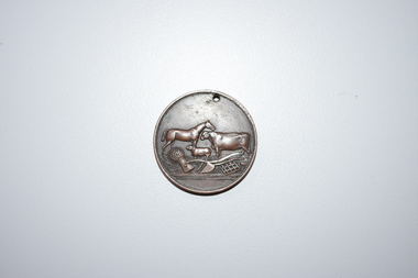 Warrnambool and District Historical Society Inc.
Medal, Stokes and Martin, Rutledge Brothers, 1877
... The latter was a pioneer settler who came to the Warrnambool/Port Fairy district as the purchaser of the Special Survey, Farnham Park in 1841. ...The latter was a pioneer settler who came to the Warrnambool/Port Fairy district as the purchaser of the Special Survey, Farnham Park in 1841. ...This medal was made by Stokes and Martin. Thomas Stokes established a medal-making business in Melbourne in 1856 and from 1867 to 1893 he had a partner, George Frederick Martin. In 1962 the Stokes business became a public company and operates today in Melbourne. The medal was awarded at the Annual Show of the Villiers and Heytesbury Agricultural Association in 1877. One of the earliest agricultural associations in Victoria, the V.& H.A.A., the forerunner of the Warrnambool Agricultural Society, was established in 1854 and the first Warrnambool Show was held in 1855 at the first Royal Archer Hotel in Koroit Street. The Warrnambool Agricultural Show is still held annually. The medal, first prize for the best horse hay rake, was awarded in 1877 to the brothers, Thomas and William Rutledge, sons of Eliza and William Rutledge. The latter was a pioneer settler who came to the Warrnambool/Port Fairy district as the purchaser of the Special Survey, Farnham Park in 1841. His land stretched from Tower Hill to Dennington. William Rutledge Senior was a pioneer breeder of a Lincoln sheep stud, the owner of a mercantile business in Port Fairy, a member of the Legislative Council of Victoria and the pioneer developer of farming land around Tower Hill. His son Thomas (1846-1918) was a Warrnambool Shire Councillor who farmed in the Farnham Survey, living at Werronggurt . He went to the Geelong area at the end of the 19th century. His brother William (1849-1935) also farmed in the Farnham Survey, living at Farnham Park, He later lived at Airlie in Henna Street, Warrnambool and Sherwood on the Hopkins River and had land in the Otway Ranges. He later went to New Zealand.This medal is of considerable significance because of its age and its association with Thomas and William Rutledge and with the Villiers and Heytesbury Agricultural Association.This is a bronze medal with an image of agricultural implements, agricultural produce and farm animals on one side and etched printing on the other side. There is also printing around the edge of the medal. The medal has a small hole at the top for attaching the medal to a cord. Villiers & Heytesbury Agricultural Association 1st Prize awarded to Rutledge Bro. for Horse Hay Rake Annual Show Warrnambool 10 Oct. 1877 Stokes & Martin Melbourne thomas and william rutledge, farnham special survey, villiers and heytesbury agricultural association, warrnambool agricultural society, history of warrnambool -
 Warrnambool and District Historical Society Inc.
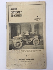
Booklet, Grand Centenary process, 1947
... settlers in the town. The 1947 celebrations included a Grand Procession which was estimated to have been watched by 20,000 people. A similar number saw the bonfire and fireworks display in Albert Park the same evening. ...settlers in the town. The 1947 celebrations included a Grand Procession which was estimated to have been watched by 20,000 people. A similar number saw the bonfire and fireworks display in Albert Park the same evening. ...This is a program of the Centenary Procession that took place in Warrnambool in 1947 to celebrate the 100th anniversary of the city’s founding in 1847. It was originally intended to celebrate the 100th anniversary in 1940 but these celebrations were postponed because of World War Two. In 1947 centenary celebrations were held but on a less lavish style. 1947 was a more appropriate year as 1847 was the year of the first land sales for Warrnambool and the arrival of the first European settlers in the town. The 1947 celebrations included a Grand Procession which was estimated to have been watched by 20,000 people. A similar number saw the bonfire and fireworks display in Albert Park the same evening. The celebrations lasted a week and included a choral thanksgiving festival in the Botanic Gardens, a massed band display and a ‘Warrnambool Can Make It’ exhibition of local manufactures. The well-known historian and Town Clerk at the time, Henri Worland took a prominent role in the organizing of the celebrations. This little booklet is of considerable importance because it contains a short description of the floats and the names of those connected with the various floats of the Warrnambool Centenary Procession of 1947. It not only gives us a better idea of what and who were in the procession but it now enables us to better label the many photographs we have of this procession and to identify the people in the photographs. The program is a valuable source of information for historians. It also is a good example of the type of celebratory procession that was popular 70 years ago. This is a paper program of the Warrnambool 1947 Centenary procession. It has four pages and a buff-coloured cover. The front cover has a sepia-toned photograph of the first car purchased in Warrnambool (1906) and on the back cover there is an advertisement for Lane’s Bus Services. The inside front cover has an advertisement for Guyett and Sons Furniture Store and there are other advertisements throughout the pages. The printed text on buff-coloured paper gives details of the 29 floats in the ‘Mechanized’ Section and of the 27 floats in the ‘Back to the Horse Pageant’ Section. The pages were stapled but the staples have been removed. There has been some silverfish damage. Front Cover: ‘Grand Centenary Procession, Thursday, March 27, 1947, Souvenir Catalogue, Price Sixpence, Joint Organisers, C.A.Rogers, P.T.Parker, F.E.Utting’. warrnambool centenary, 1947 henri worland -
 Warrnambool and District Historical Society Inc.
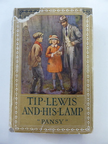
Book, Tip Lewis & his lamp, 1925
... settlers in the Wangoom/Grasmere area. Some Jenkins families were associated with hotels in Purnim and Woodford and the properties Grasmere Station, Roseneath, Dyffen, Vrowen and Fala Park. ...settlers in the Wangoom/Grasmere area. Some Jenkins families were associated with hotels in Purnim and Woodford and the properties Grasmere Station, Roseneath, Dyffen, Vrowen and Fala Park. ...This book was awarded by the Grasmere Presbyterian Sabbath School to Stuart Jenkins for his essay on the Apostle Paul. The teacher was H. Giles. The Giles family lived on the Allansford Road in the early 20th century. There were several Jenkins families in the Warrnambool district and some were early settlers in the Wangoom/Grasmere area. Some Jenkins families were associated with hotels in Purnim and Woodford and the properties Grasmere Station, Roseneath, Dyffen, Vrowen and Fala Park. St. Andrew’s Presbyterian Church at Grasmere was built in 1898 (the second church on the site). This book is an example of Sabbath School prizes awarded to scholars in the 1920's. It is retained for its connection to the Grasmere Presbyterian Church and the Jenkins and Giles families of the Wangoom and Grasmere area.This is a hard cover book of 252 pages. The cover is brown with a multi-coloured illustration of a man and two children on the front cover and black lettering and border ornamentation on the spine and front cover. The dust jacket has a yellow background and the same illustration as on the front cover. The dust cover is partly torn away. There is a full page colour plate at the beginning of the text and a page of advertisements for books by the same publisher at the end of the text. The inscription is handwritten in black ink. ‘Grasmere Presbyterian Sabbath School ‘Essay’ Missionary Journeys of the Apostle Paul. First Prize Awarded to Stuart Jenkins from his teacher, H. Giles’. stuart jenkins, grasmere, history of warrnambool, grasmere presbyterian church, h giles -
 Raymond Island Historical Society
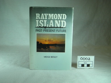
Book, Midge Beesley, Raymond Island:past present future, 1986
... Contents: Raymond Island early settlers, indigenous history, Island identities, Raymond Island State School, a'Beckett Park, Raymond Island Ferry, The Presbyterian Church, raymond Island Advancement League ...Contents: Raymond Island early settlers, indigenous history, Island identities, Raymond Island State School, a'Beckett Park, Raymond Island Ferry, The Presbyterian Church, raymond Island Advancement League Raymond Island:past present future Book Midge Beesley James Yeates Midge Beesley ...Local history of Raymond Island. Includes stories of Island identities, maps, photographsLocal significance Out of print publicationMonograph publication 291 pages Hardback Loose cover Maps Sunset picture of lake from Raymond Island on front cover Photographs of people, buildings, Raymond Island ferries, boats. Contents: Raymond Island early settlers, indigenous history, Island identities, Raymond Island State School, a'Beckett Park, Raymond Island Ferry, The Presbyterian Church, raymond Island Advancement League park, gippsland lakes, raymond island, raymond island state school, a beckett, raymond island ferry, early, settlers, raymond island advancement league -
 Kiewa Valley Historical Society
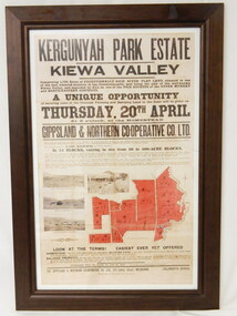
Poster - Framed - Kergunyah
... David and Henrietta Wallace purchased the original holding and built Kergunyah Park homestead in the late 1800's running cattle on the property. They arrived in Australia in 1867 with their 3 children and were early settlers in the district. ...in 1922 Kergunyah Park homestead was built by David Wallace in the late 1800's and remained in the family until the sale in 1922 when it was bought by John Woodside (grandfather of Ewen Wallace) whose family retained it until 1938. Another family named Wallace bought the property in 1938 and this family's descendants are still running it in 2005.David and Henrietta Wallace purchased the original holding and built Kergunyah Park homestead in the late 1800's running cattle on the property. They arrived in Australia in 1867 with their 3 children and were early settlers in the district. Their descendants still live in the district. Their family demonstrates how properties were passed on to the next generation. The poster is an example of the advertising of the sale of land in 1922, the size of land & blocks and the conditions of sale at the time.Large cloth map mounted under glass with a brown wooden frame. Brown writing detailing Kergunyah Park 1923 Sale Record. Includes 4 rectangular brown and white photos and a red map showing 13 blocks of land. Has hanging wire attached on the back."Framed by / Clarkson Collection / Ph; 02 6059 6800"kergunyah. kiewa valley. kergunyah park homestead. ewen wallace. john woodside. -
 Emerald Museum & Nobelius Heritage Park
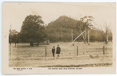
Postcard - Postcard of Hanging Rock, Kyneton, Vic
... Emerald Museum & Nobelius Heritage Park 5 Crichton Rd Emerald yarra-valley-and-the-dandenong-ranges This postcard is part of an album of postcards which date from late 19th century to mid 20th century. It depicts Hanging Rock, a large rock formation sacred to First Nations people for thousands of years prior to European settlement. Hanging Rock became a recreational place for settlers ...This postcard is part of an album of postcards which date from late 19th century to mid 20th century. It depicts Hanging Rock, a large rock formation sacred to First Nations people for thousands of years prior to European settlement. Hanging Rock became a recreational place for settlers during the 19th century and then became famous through the novel 'Picnic at Hanging Rock' (1967) and the subsequent movie (1975) of the same name. The photograph appears to be c1900s-1920s.This postcard is in an album of postcards dating from the late 19th century to mid 20th century. It reflects the popularity of collecting postcards in Australia which reached a height in the early 1900s until around 1920. Photographic black and white postcard of Hanging Rock c1900s-1920sOn front, printed: 'THE ROSE SERIES, P.1558 THE HANGING ROCK NEAR KYNETON, VICTORIA / Copyright' On back, printed: 'Post Card / The "Rose" Series De Luxe Produced in Australia On extreme left side of back, printed:'[unclear word] By "THE ROSE STENOGRAPHS" / Armadale, Victoria'postcard, photography, 1900s, hanging rock, 1920s, "green postcard album" -
 Emerald Museum & Nobelius Heritage Park
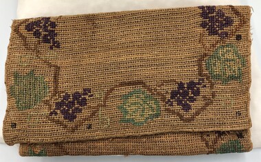
Accessory - Small Hessian Bag, Flora Ryberg, Early 20th century
... Park and of the Emerald Museum. This bag has been donated by Flora's daughter. This bag was made by the mother of Emerald's outstanding community worker and local history promoter, Gus Ryberg. It is also an example of early settlers ...This small hessian bag was made and embroidered by Flora Ryberg (nee Warner), an Australian born woman of English parentage who married a Swedish seaman, Frits Ryberg. the couple lived in Emerald. Their son, Gus Ryberg (1911 - 2000) was a tireless promoter of local history and was pivotal in the establishment of the Nobelius Heritage Park and of the Emerald Museum. This bag has been donated by Flora's daughter.This bag was made by the mother of Emerald's outstanding community worker and local history promoter, Gus Ryberg. It is also an example of early settlers using spare materials at their disposal to make something useful.Small hessian bag with flap. A length of hessian has been embroidered. One third has then been folded over and sewn at the edges to create an overlapping bag.On front of bag when flap is lifted is an embroidered letter: 'N'flora ryberg, flora warner, gus ryberg -
 Emerald Museum & Nobelius Heritage Park
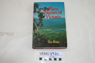
Book, Place Names of Victoria, 1977
... Emerald Museum & Nobelius Heritage Park 5 Crichton Rd Emerald yarra-valley-and-the-dandenong-ranges The sequence of naming was a chronological representative of land discovery and settlement. Starting from the native population to the explorers, the squatters and settlers and surveyors during the gold rush. ...The sequence of naming was a chronological representative of land discovery and settlement. Starting from the native population to the explorers, the squatters and settlers and surveyors during the gold rush. The term 'places' refers to physical features of the coast and land as well as districts, towns and cities.Hard Cover book written by Les Blake and first published in 1977. The jacket has a photograph of Mount Beauty and the Kiewa Valley from the Tawonga Gap.place names of victoria -
 Emerald Museum & Nobelius Heritage Park
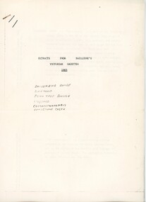
Booklet - Extracts from Bailliere's Victorian Gazetter 1865, Robert Whitworth, 1865
... Park 5 Crichton Rd Emerald yarra-valley-and-the-dandenong-ranges Robert Whitworth (1831 -1901), an England-born journalist and author worked with the government printer Ferdinand François Balliere in producing gazetteers of the Australian colonies. The first was a gazetteer of Victoria printed in 1865. This copied extract from that gazetter provides information about the fauna and flora and geology of Emerald and environs at an early period of European settlement in Victoria. This gazetter extract provides a picture of Emerald and environs as described by a settler ...Robert Whitworth (1831 -1901), an England-born journalist and author worked with the government printer Ferdinand François Balliere in producing gazetteers of the Australian colonies. The first was a gazetteer of Victoria printed in 1865. This copied extract from that gazetter provides information about the fauna and flora and geology of Emerald and environs at an early period of European settlement in Victoria.This gazetter extract provides a picture of Emerald and environs as described by a settler in the mid-19th century.Four foolscap pages of information photocopied regarding the Dandenong Ranges and environs. Pages attached with a staple.On first page: ' EXTRACTS FROM BAILLIERE'S / VICTORIAN GAZETTER / 1865 / DANDENONG RANGE / EMERALD / FERN TREE GULLIES / LILYDALE / CORRANWARRABUL / DANDENONG CREEK'robert whitworth, balliere, gazetter, emerald, 1865 -
 Orbost & District Historical Society
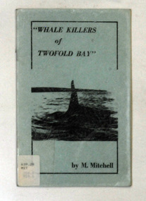
books, Whale Killers of Twofold Bay, circa 1960
... settlers. Mary Wellings married Roy Mitchell of Lower Towamba. In Eden there are streets and a park named for both families....settlers. Mary Wellings married Roy Mitchell of Lower Towamba. In Eden there are streets and a park named for both families. ...Author, Mary Mitchell was the daughter of Charles Wellings early resident of Eden. Charles took many of the early photos of Eden while his brother, Henry, did the research on the Imlay Bros (very early settlers of Orbost) and early Twofold Bay settlers. Mary Wellings married Roy Mitchell of Lower Towamba. In Eden there are streets and a park named for both families.These books record the history of the whaling industry on the south coast of New South Wales.Two copies of a small thin ten page booklet with blue laminated covers. It has black print and a black photo of a whale tail on the front cover.It was written by Mary Mitchell. The book relates the history of whaling at Twofold Bay on the south coast of New South Wales.2116.1 - has a library sticker on the front cove - bottom left hand cornertwofold-bay whaling mitchell-mary welliings -
 Bunjil Park Aboriginal Education & Cultural Centre
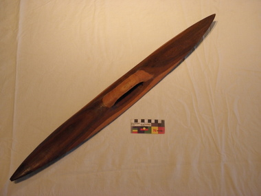
fighting shield, Before european settlement
... Bunjil Park Aboriginal Education & Cultural Centre Neilborough goldfields This wooden shield was used in hand to hand fighting between Jaara people and other tribes and with European settlers. ...This wooden shield was used in hand to hand fighting between Jaara people and other tribes and with European settlers. It was made for personal use by one warrior and would have been passed on to his next nearest male kin. If it did not fit them, it would have been placed with the body of the warrior.This shied was gifted to Uncle Brien Nelson when he was working in Portland. This wooden fighting shield is undecorated and fashioned for use in either the left or right hand. It is elongated finishing in points at the top and bottom. It is carved from a single piece of wood and has a handle carved into the back. The shield has some minor striations on the front which may have been produced during fighting -
 Eltham District Historical Society Inc
Audio - Audio Recording, Jim Connor - Eltham Lower Park, 8 Feb. 2023
... Park for thousands of years. Waterway junctions had a particular attraction as tribal meeting places and the junction of the Diamond Creek with the Yarra River (Birr-arung to the Wurundjeri) was one such important location in terms of aboriginal culture. The sculpture “Not Just a Pretty Place” by Aleks Danko, located near the junction of these two watercourses pays tribute to this important cultural location. The first European settlers...Park for thousands of years. Waterway junctions had a particular attraction as tribal meeting places and the junction of the Diamond Creek with the Yarra River (Birr-arung to the Wurundjeri) was one such important location in terms of aboriginal culture. The sculpture “Not Just a Pretty Place” by Aleks Danko, located near the junction of these two watercourses pays tribute to this important cultural location. The first European settlers ...EDHS Newsletter No. 268 February 2023 Prior to the extension of European people into the lands of the Nillum-bik in the late 1830s the Wurundjeri people had been meeting in the area now known as Eltham Lower Park for thousands of years. Waterway junctions had a particular attraction as tribal meeting places and the junction of the Diamond Creek with the Yarra River (Birr-arung to the Wurundjeri) was one such important location in terms of aboriginal culture. The sculpture “Not Just a Pretty Place” by Aleks Danko, located near the junction of these two watercourses pays tribute to this important cultural location. The first European settlers were squatters or leaseholders and itinerants such as timber workers. Records of their early occupation are sketchy but the Eltham Lower Park area was probably included within the pastoral run established in 1841 by Henry Foley. He sold his leasehold in 1845 to Joseph Wilson who in turn sold it to Frederick Faulkner soon after. From this early history the Eltham Lower Park area has undergone many changes and has been developed to provide residents and visitors with a range of passive and active public open space, including even being used for various horse racing events. At our next meeting, Jim Connor will explore the history of Eltham Lower Park and touch on various individuals and groups involved along the way.1:05:19 duration Digital MP3 file; 22.4MBaudio recording, eltham district historical society, meeting, society meeting, jim connor, eltham, eltham lower park -
Eltham District Historical Society Inc
Document - Folder, Partington family
... settler in Greensborough, and his brother-in-law Charles Partington. Newspaper article: "How early families linked up", Diamond Valley News, 28 February 1984. Alan Partington's research into the Ruston and Medhurst families. Newspaper article: "Old days recalled", Diamond Valley News, 13 March 1984. Alan Partington's research in the Partington family. Alan Partington Robert Whatmough Watmough Park ...Charles Partington married Ellen Whatmough; they and their children, Robert and James, came to Australia in 1857 because Ellen's brother, Robert Whatmough, had come here in 1841. Whatmough was Melbourne's first lamplighter while also working in John Batman's Spencer Street orchard; he moved in 1842 to establish an orchard in Greensborough. Both Partington boys died soon after the family arrived at Greensborough but later two daughters were born, Prudina and Maria, and five sons, including William . On arrival Charles Partington began work for Mr Flintoff at Black Hills and was later toll keeper on what is now Watsonia Road. He was later a successful orchardist. William Partington married Annie-May Medhurst, daughter of David Medhurst and Martha Ruston, daughter of Peter Ruston who had settled in Greensborough in the 1850s after working for Mr Hooper in Darebin Creek, then moved to Panton Hill in 1866 working as a carrier. The Rustons had six children, including Martha and James. Martha married David Medhurst in 1882 who was the son of David Medhurst and Charity Jane Pink. After David's death, Charity Jane married George Wescott. David and Martha Medhurst had eight children, including Annie May. They bought land in Main Street, Greensborough and set up as a greengrocer. William and Annie-May Partington's family home, Willis Vale, purchased from Mr Meagher by William's father, Charles; it was built by Meagher in 1839 but destroyed by vandals in 1966 after being compulsory purchased for parkland now called Partington's Flat. Their children were Eva, Grace, Alan, Jessie, and Jack. They attended Greensborough Primary School. Alan married Wyn. Contents Newspaper article: "Link with the past", Diamond Valley News, 21 February 1984. Alan Partington's research on Robert Whatmough, early settler in Greensborough, and his brother-in-law Charles Partington. Newspaper article: "How early families linked up", Diamond Valley News, 28 February 1984. Alan Partington's research into the Ruston and Medhurst families. Newspaper article: "Old days recalled", Diamond Valley News, 13 March 1984. Alan Partington's research in the Partington family.Newspaper clippings, A4 photocopies, etcalan partington, robert whatmough, watmough park greensborough, robert partington, james partington, elen partington nee whatmough, road tolls watsonia road, prudina partington, maria partington, william partington, willis vale, partington's flat greensborugh, mr meagher of greensborough, apollo parkways estate, charles partington, annie-may partington nee medhurst, david medhurst, martha medhurst (nee ruston), jack medhurst, peter ruston, hooper of darebin creek, greensborough hotel, james ruston, charity jane medhurst (nee pink), main street greensborough, eva partington, grace partington, jessie partington, jack partington, orchards in plenty river area, greensborough primary school, wyn partington, flintoff of black hills -
 Eltham District Historical Society Inc
Photograph - Digital Photograph, Alan King, Garden Hill, Eltham-Yarra Glen Road, Kangaroo Ground, 3 February 2008
... park. The White family sold the property to Sir Herbert Gepp in 1925. Covered under Heritage Overlay, Nillumbik Planning Scheme. Published: Nillumbik Now and Then / Marguerite Marshall 2008; photographs Alan King with Marguerite Marshall.; p29 Garden Hill, on Yarra Glen Road, Kangaroo Ground, near the War Memorial is well named. The old house and gardens overlook a magnificent panorama extending to Kinglake. The original house, built around 1850, was one of Kangaroo Ground’s earliest, and part of it remains in today’s timber house. The house was built by the early and prominent settler...park. The White family sold the property to Sir Herbert Gepp in 1925. Covered under Heritage Overlay, Nillumbik Planning Scheme. Published: Nillumbik Now and Then / Marguerite Marshall 2008; photographs Alan King with Marguerite Marshall.; p29 Garden Hill, on Yarra Glen Road, Kangaroo Ground, near the War Memorial is well named. The old house and gardens overlook a magnificent panorama extending to Kinglake. The original house, built around 1850, was one of Kangaroo Ground’s earliest, and part of it remains in today’s timber house. The house was built by the early and prominent settler ...The original house was built around 1850 was one of Kangaroo Ground's earliest homes, part of which remains today. Built by Scottish farmer Andrew Harkness who acquired the property in 1849 at the top of the hill with magnificent panoramic views as far as Kinglake, the same year he married Sarah Oswin. The property was known as Garden Hill from at least 1865. Andrew and Sarah had four sons and five daughters. Harkness was a founder of the Kangaroo Ground School and one of the first to suggest establishing the Eltham District Road Board (1858-71) of which he was a member, the pre-cursor to the Shire of Eltham (1871-1994). He was also a Trustee of the Kangaroo Ground Cemetery. His daughter Fanny married farmer Alexander White who purchased the property in 1893. Alexander White died in 1906 and ownership transferred to Fanny White. Son, Robert White was a Councillor of the Shire of Eltham at the time the Shire acquired two acres of land on the adjacent property from the Mess brothers for the creation of the Shire of Eltham Memorial Park (1921) in which the Shire of Eltham War Memoirial tower was erected (1926). Fanny White donated a small section of land from the Garden Hill property to facilitate entry access to the park. The White family sold the property to Sir Herbert Gepp in 1925. Covered under Heritage Overlay, Nillumbik Planning Scheme. Published: Nillumbik Now and Then / Marguerite Marshall 2008; photographs Alan King with Marguerite Marshall.; p29 Garden Hill, on Yarra Glen Road, Kangaroo Ground, near the War Memorial is well named. The old house and gardens overlook a magnificent panorama extending to Kinglake. The original house, built around 1850, was one of Kangaroo Ground’s earliest, and part of it remains in today’s timber house. The house was built by the early and prominent settler Andrew Harkness. Later it was occupied for a long time by Sir Herbert Gepp, renowned Australia wide.1 Harkness and Gepp are buried in the Kangaroo Ground Cemetery. Scottish farmer Harkness, who was born in 1817, acquired this property in 18492 and he and his family occupied it until the early 1920s. Harkness cleared its 152 acres (61.4 ha), fenced it and grazed sheep and cattle. Harkness proved a valuable community member. When only ten families lived in the district, he and other settlers set up a school in 1852, with Andrew Ross as the first teacher. Harkness was also one of the first to suggest establishing the Eltham District Road Board, of which he was a member for around 15 years. He was also a trustee of the Kangaroo Ground Cemetery. Harkness married in 1854 and had four sons and five daughters. The first part of the timber house he built included a kitchen-living room and a parlor. The living room’s large fireplace was bricked-in and modernised in 1940. Beside it is the old baker’s oven with its original iron door replaced by a wooden one. It is thought two wattle-and-daub huts, used for a bedroom and bathroom, were built to the west. Harkness’ son-in-law, farmer Alexander White, who had seven sons, bought the property in 1893. Harkness’ grand-daughter Flora married Ewen Cameron who became Minister for Health and was later knighted; he was not related to Ewen Hugh Cameron, a Member of the Legislative Assembly. In 1923 the White family sold the property, called Kilby Park, to Sir Herbert Gepp, who renamed it Garden Hill. Gepp used the property, which was still on the original New South Wales title, as a hobby farm. Robert White stayed on to manage the farm for a while, living in a house on the property. Gepp was born in 1877 and at 16 years began working as a junior chemist with the Australian Explosives and Chemical Company at Deer Park near Melbourne. Gepp was a pioneer in applying enlightened labour policies in industry. He initiated the Broken Hill Progress Association, to improve living conditions. It laid the ground work for the welfare schemes pursued by companies after World War One. During the mid 20th century Gepp was the most prominent liberal thinker associated with conservative politics. As a friend of Prime Minister John Curtin, he contributed to post-war reconstruction. Gepp returned to private industry and retired in 1950. Gepp made significant contributions to the solution of the great metallurgical problems of the mining industry. He was an advocate of the role of science in industry, government and the economy and helped to establish several organizations including the CSIR and the Institute of Public Affairs.3 After Sir Herbert died in 1954 his son Orwell continued to farm the property part-time. When Lady Gepp died in 1963, the land was divided among the five children, although Orwell continued to farm it as a hobby. In 1966, a daughter, Mardi Gething, now married, settled in the house. Another daughter, Kathleen, built her house close by on the property. After the Board of Works designated the property as part of a reserve for a possible reservoir, the family sold all, except the minimum 20 acres allowed, to the Board in the 1970s. Orwell then leased what was the family property from the Board to continue grazing. The two sisters and brother continued to live on the property.This collection of almost 130 photos about places and people within the Shire of Nillumbik, an urban and rural municipality in Melbourne's north, contributes to an understanding of the history of the Shire. Published in 2008 immediately prior to the Black Saturday bushfires of February 7, 2009, it documents sites that were impacted, and in some cases destroyed by the fires. It includes photographs taken especially for the publication, creating a unique time capsule representing the Shire in the early 21st century. It remains the most recent comprehenesive publication devoted to the Shire's history connecting local residents to the past. nillumbik now and then (marshall-king) collection, kangaroo ground -
 Eltham District Historical Society Inc
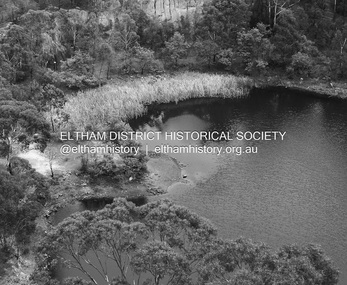
Photograph - Digital Photograph, Alan King, Blue Lake, Plenty Gorge Park, 2008
... The Plenty Valley was among the first in the Port Phillip District to be settled - mainly in the less heavily timbered west - and was proclaimed a settled district in 1841.But by the late 1880s, the settlers’ extensive land clearing for animal grazing, then agriculture, depleted the Wurundjeri’s traditional food sources, which helped to drive them away. Many Wurundjeri artefacts remain (now government protected), and so far 57 sites have been identified in the park, including scarred trees, burial areas and stone artefacts. ...The Plenty Valley was among the first in the Port Phillip District to be settled - mainly in the less heavily timbered west - and was proclaimed a settled district in 1841.But by the late 1880s, the settlers’ extensive land clearing for animal grazing, then agriculture, depleted the Wurundjeri’s traditional food sources, which helped to drive them away. Many Wurundjeri artefacts remain (now government protected), and so far 57 sites have been identified in the park, including scarred trees, burial areas and stone artefacts. ...A quarry was transformed into the Blue Lake. Published: Nillumbik Now and Then / Marguerite Marshall 2008; photographs Alan King with Marguerite Marshall.; p179 The dramatic steep-sided Plenty Gorge lies along the divide of two geological areas, and separates the Nillumbik Shire and the City of Whittlesea. On the Nillumbik side are undulating hills and sedimentary rock, and in Whittlesea, lies a basalt plain formed by volcanic action up to two million years ago. This provides the Plenty Gorge Park with diverse vegetation and habitats, making it one of Greater Melbourne’s most important refuges for threatened and significant species. The park, established in 1986, consists of around 1350 hectares, and extends 11 kilometres along the Plenty River, from Greensborough to Mernda. It provides a wildlife corridor for around 500 native plant and 280 animal species. The area’s plentiful food and water attracted the Wurundjeri Aboriginal people and then European settlers. By 1837 squatters had claimed large runs of land for their sheep and cattle. The Plenty Valley was among the first in the Port Phillip District to be settled - mainly in the less heavily timbered west - and was proclaimed a settled district in 1841.But by the late 1880s, the settlers’ extensive land clearing for animal grazing, then agriculture, depleted the Wurundjeri’s traditional food sources, which helped to drive them away. Many Wurundjeri artefacts remain (now government protected), and so far 57 sites have been identified in the park, including scarred trees, burial areas and stone artefacts. Pioneer life could be very hard because of isolation, flooding, bushfires and bushrangers. Following the Black Thursday bushfires of 1851, basalt was quarried to build more fire-resistant homes. Gold discoveries in the early 1850s swelled the population, particularly around Smugglers Gully; but food production made more of an impact. In the late 1850s wheat production supplanted grazing. In the 1860s the government made small holdings available to poorer settlers. These had the greatest effect on the district, particularly in Doreen and Yarrambat, where orchards were established from the 1880s to 1914. Links with a prominent early family are the remains of Stuchbery Farm, by the river’s edge bounded by Smugglers Gully to the north and La Trobe Road, Yarrambat, to the east. The Stuchberys moved to the valley in 1890, and the family still lives in the area. In 1890, Alfred and Ada first lived in a tent where four children were born, then Alfred built the house and outbuildings around 1896. They planted an orchard, then a market garden, and developed a dairy. The family belonged to the local Methodist and tennis communities. Their grandson Walter, opened the Flying Scotsman Model Railway Museum in Yarrambat, which his widow, Vi, continues to run. Wal was also the Yarrambat CFA Captain for 22 years until 1987. Walter sold 24 hectares in 1976 for development - now Vista Court - and in 1990, the remaining 22.6 hectares for the park. Remaining are an early stone dairy and remnants of a stone barn, a pig sty and a well. Until it was destroyed by fire in 2003, a slab hut stood on the Happy Hollow Farm site, at the southern end of the park. The hut is thought to have been built in the Depression around 1893. This was a rare and late example of a slab hut with a domestic orchard close to Melbourne. Emmet Watmough and his family first occupied the hut, followed by a succession of families, until the Bell family bought it around 1948. There they led a subsistence lifestyle for 50 years, despite encroaching Melbourne suburbia. The Yellow Gum Recreation Area includes the Blue Lake, coloured turquoise at certain times of the year. Following the 1957 bushfires, this area was quarried by Reid Quarries Pty Ltd for Melbourne’s first skyscrapers, then by Boral Australia. However in the early 1970s water began seeping into the quarry forming the Blue Lake and the quarry was closed. The State Government bought the site in 1997 and opened it as a park in 1999.This collection of almost 130 photos about places and people within the Shire of Nillumbik, an urban and rural municipality in Melbourne's north, contributes to an understanding of the history of the Shire. Published in 2008 immediately prior to the Black Saturday bushfires of February 7, 2009, it documents sites that were impacted, and in some cases destroyed by the fires. It includes photographs taken especially for the publication, creating a unique time capsule representing the Shire in the early 21st century. It remains the most recent comprehenesive publication devoted to the Shire's history connecting local residents to the past. nillumbik now and then (marshall-king) collection, blue lake, plenty gorge park -
 Eltham District Historical Society Inc
Photograph, Upper Yarra Dam, Spring Tour, 22 Oct 1995, 22/10/1995
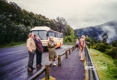
... settlers. Starting by crossing the new (1974) concrete bridge at Warrandyte we headed through Wonga Park with views to the Christmas Hills and to the escarpment of the Yering Gorge, which causes flood waters to back up through the Yarra Glen plain, so avoiding disasters downstream. ...settlers. Starting by crossing the new (1974) concrete bridge at Warrandyte we headed through Wonga Park with views to the Christmas Hills and to the escarpment of the Yering Gorge, which causes flood waters to back up through the Yarra Glen plain, so avoiding disasters downstream. ...EXPLORING THE UPPER YARRA (Newsletter No. 105, November 1995, by Bettina Woodburn) We enjoyed the Spring Excursion, this year "Exploring the Upper Yarra" - in spite of the constant rain and the countryside under the cloud cover, especially in the valleys, being mainly shiny shades of green. The occasional fields of buttercups, clumps of arum lilies and splendid rhododendron and other flowering bushes became very special. The Cobb and Co coach was warm and a cosy retreat as we zig-zagged on the highways and byways to glimpse the Yarra River, upstream and down, its secret places, and particularly the many bridges. Russell excelled as 'Poet Laureate', reading from Dacre Smyth's book. This 1979 publication includes paintings of all the bridges along the river with poems and brief descriptions of each one. Some of the bridges are in out of the way places and are not very well known. We looked forward to hearing the poetry as much as seeing the ' constructions'…Big Pat (was he short or tall, lean or fat? He did win the two hundred pound reward for discovering gold and had the creek named after him), about the 'Eddies'?, and the disliked 'meccano' bridge in Warburton, etc. etc. The hot roast lunch in the old Reefton Hotel was also most welcome. It was easy to imagine it peopled by miners and early settlers. Starting by crossing the new (1974) concrete bridge at Warrandyte we headed through Wonga Park with views to the Christmas Hills and to the escarpment of the Yering Gorge, which causes flood waters to back up through the Yarra Glen plain, so avoiding disasters downstream. At the end of a long driveway we found the wooden, privately owned Henley Bridge (1935 after the 1934 floods). This facilitates access to different parts of Henley Farm and to Lilydale. Everard Park, named after Blanche Shallard's father, a State Member for 17 years, below the Highway Yarra crossing was in need of care. It is 10 miles from Yarra Glen by road but, as "Yarra Marra” canoeists well know, 32 winding miles down by water. After more delightful countryside scenes we joined the Warburton Highway at Woori Yallock. From the old Railway Station at Launching Place the Centennial Trail for walkers, cyclists and ' horse riders has replaced the rails. The line from Lilydale was opened in 1901, and the last diesel freight train ran to Warburton in 1965. It continued to rain as we had morning tea in Warburton in a shelter between footbridges. From here we continued upstream past the Bridge to O'Shannasy Lodge and Reservoir, Starvation Creek, and the Peninsular tunnel (miners dug it as at Pound Bend) which we visited (scrambling down those steps!) on our return after lunch. Our furthermost point was the Upper Yarra Dam Reserve (and vast catchment area). Finished in 1957 after ten years work and 100 years after Yan Yean, it supplies much of Melbourne's water. After crossing the 30m Launching Place Bridge to the Eltham side of the Yarra and Healesville, we saw in the distance the Yarra Glen Timber Trestle Bridge over the river flats "the longest for years in the land it was said!" Harry's dream of "better weather over the Divide" unfortunately didn't come true, but I'm sure we 36 members will retain happy memories of a day that was wet and green and filled with Bridges. Bettina Woodburn - October 1995 Record of the Society's history of activities - Spring 1995 excursionColour photographshire of eltham historical society, activities, upper yarra dam, henley bridge -
 Eltham District Historical Society Inc
Photograph - Digital Photograph, Marguerite Marshall, Stuchbery Farm dairy, 14 March 2008
... But by the late 1880s, the settlers’ extensive land clearing for animal grazing, then agriculture, depleted the Wurundjeri’s traditional food sources, which helped to drive them away. Many Wurundjeri artefacts remain (now government protected), and so far 57 sites have been identified in the park, including scarred trees, burial areas and stone artefacts. ...But by the late 1880s, the settlers’ extensive land clearing for animal grazing, then agriculture, depleted the Wurundjeri’s traditional food sources, which helped to drive them away. Many Wurundjeri artefacts remain (now government protected), and so far 57 sites have been identified in the park, including scarred trees, burial areas and stone artefacts. ...Stuchbery Farm was situated on the Plenty River bounded by Smugglers Gully to the north and La trobe Road, Yarrambat, to the east. Alan and Ada Stutchbery moved to the valley in 1890, first living in a tent where four children were born. Alfred built a home and outbuildings around 1896. They planted an orchard, then a market garden and developed a dairy. Published: Nillumbik Now and Then / Marguerite Marshall 2008; photographs Alan King with Marguerite Marshall.; p179 The dramatic steep-sided Plenty Gorge lies along the divide of two geological areas, and separates the Nillumbik Shire and the City of Whittlesea. On the Nillumbik side are undulating hills and sedimentary rock, and in Whittlesea, lies a basalt plain formed by volcanic action up to two million years ago. This provides the Plenty Gorge Park with diverse vegetation and habitats, making it one of Greater Melbourne’s most important refuges for threatened and significant species. The park, established in 1986, consists of around 1350 hectares, and extends 11 kilometres along the Plenty River, from Greensborough to Mernda. It provides a wildlife corridor for around 500 native plant and 280 animal species. The area’s plentiful food and water attracted the Wurundjeri Aboriginal people and then European settlers. By 1837 squatters had claimed large runs of land for their sheep and cattle. The Plenty Valley was among the first in the Port Phillip District to be settled - mainly in the less heavily timbered west - and was proclaimed a settled district in 1841. But by the late 1880s, the settlers’ extensive land clearing for animal grazing, then agriculture, depleted the Wurundjeri’s traditional food sources, which helped to drive them away. Many Wurundjeri artefacts remain (now government protected), and so far 57 sites have been identified in the park, including scarred trees, burial areas and stone artefacts. Pioneer life could be very hard because of isolation, flooding, bushfires and bushrangers. Following the Black Thursday bushfires of 1851, basalt was quarried to build more fire-resistant homes. Gold discoveries in the early 1850s swelled the population, particularly around Smugglers Gully; but food production made more of an impact. In the late 1850s wheat production supplanted grazing. In the 1860s the government made small holdings available to poorer settlers. These had the greatest effect on the district, particularly in Doreen and Yarrambat, where orchards were established from the 1880s to 1914. Links with a prominent early family are the remains of Stuchbery Farm, by the river’s edge bounded by Smugglers Gully to the north and La Trobe Road, Yarrambat, to the east. The Stuchberys moved to the valley in 1890, and the family still lives in the area. In 1890, Alfred and Ada first lived in a tent where four children were born, then Alfred built the house and outbuildings around 1896. They planted an orchard, then a market garden, and developed a dairy. The family belonged to the local Methodist and tennis communities. Their grandson Walter, opened the Flying Scotsman Model Railway Museum in Yarrambat, which his widow, Vi, continues to run. Wal was also the Yarrambat CFA Captain for 22 years until 1987. Walter sold 24 hectares in 1976 for development - now Vista Court - and in 1990, the remaining 22.6 hectares for the park. Remaining are an early stone dairy and remnants of a stone barn, a pig sty and a well. Until it was destroyed by fire in 2003, a slab hut stood on the Happy Hollow Farm site, at the southern end of the park. The hut is thought to have been built in the Depression around 1893. This was a rare and late example of a slab hut with a domestic orchard close to Melbourne. Emmet Watmough and his family first occupied the hut, followed by a succession of families, until the Bell family bought it around 1948. There they led a subsistence lifestyle for 50 years, despite encroaching Melbourne suburbia. The Yellow Gum Recreation Area includes the Blue Lake, coloured turquoise at certain times of the year. Following the 1957 bushfires, this area was quarried by Reid Quarries Pty Ltd for Melbourne’s first skyscrapers, then by Boral Australia. However in the early 1970s water began seeping into the quarry forming the Blue Lake and the quarry was closed. The State Government bought the site in 1997 and opened it as a park in 1999.This collection of almost 130 photos about places and people within the Shire of Nillumbik, an urban and rural municipality in Melbourne's north, contributes to an understanding of the history of the Shire. Published in 2008 immediately prior to the Black Saturday bushfires of February 7, 2009, it documents sites that were impacted, and in some cases destroyed by the fires. It includes photographs taken especially for the publication, creating a unique time capsule representing the Shire in the early 21st century. It remains the most recent comprehenesive publication devoted to the Shire's history connecting local residents to the past. nillumbik now and then (marshall-king) collection, ada stuchbery, alan stuchbery, dairy, stuchbery farm, farm buildings, yarrambat, plenty gorge park -
 Eltham District Historical Society Inc
Photograph, Fay Bridge, Moor-rul Viewing Platform, Garden Hill, Kangaroo Ground, n.d
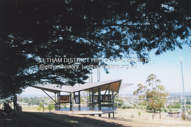
... Park and its Tower of Remembrance is located on one of the highest locations in the Yarra Valley. The Tower of Remembrance is a unique war memorial constructed from local stone standing 14 metres high. It was built in the style of a Scottish watchtower reflecting the strong Scottish influence of the first European settlers of the district from the 1840s onward. ...Park and its Tower of Remembrance is located on one of the highest locations in the Yarra Valley. The Tower of Remembrance is a unique war memorial constructed from local stone standing 14 metres high. It was built in the style of a Scottish watchtower reflecting the strong Scottish influence of the first European settlers of the district from the 1840s onward. ...OPENING OF THE VIEWING PLATFORM AT KANGAROO GROUND Nillumbik Council has advised that the viewing platform at Kangaroo Ground 27km NE of Melbourne is to be opened to the public on Wednesday, March 26th 2008 (Melway 271 , G10). The function of the platform is to provide shelter adjacent to the War Memorial Tower whilst allowing all people to enjoy the stunning panoramic views. From the platform you. can see the Dandenongs, the city of Melbourne, the You Yangs, Mount Macedon, the Kinglake Ranges and the Mt Baw-Baw Ranges where the Yarra River starts. This landscape covers all the ancestral lands of the Wurundjeri and some of the wider Kulin nation land. The platform has been given the name Moor-rut, a name which described the fertile soils of the Kangaroo Ground area in contrast to the poorer (Silurian) country of its surrounds, which the Wurundjeri knew as 'Nillumbik' or less rich country. The full 360 degree view can be seen from the adjacent Tower of Remembrance which has 53 stairs. The viewing platform however can be accessed by wheelchair. Inside the viewing platform there are eight double sided interpretive panels giving the history and information regarding this special area. The viewing platform's interpretive panels set out the Aboriginal and European history of the area and also the geology and the local flora and fauna, so that the casual visitor comes away understanding more about this significant part of Victoria. The concept of the viewing platform is part of the refurbishment project for the Kangaroo Ground War Memorial Park which has taken place since 1997 with the active approval and financial assistance of the Nillumbik Shire Council. This project has been guided by an Advisory Committee with volunteer community representatives from the local Historical Societies, the Country Fire Authority, the Returned Services League and the Wurundjeri people. Other allied groups such as the Nillumbik Reconciliation Group have been called upon for their expertise. The initial idea for the viewing platform came from Dean Stewart when he was the caretaker while living at the park. He discussed this idea with local author Mick Woiwod and Harry Gilham of Eltham District Historical Society when they were planning the refurbishment of the War Memorial Park in 1996. When the committee was formalised by the Nillumbik Council in 1997, Nicholas Pelling, representing the CFA and RSL, joined the group. Dennis Ward, local architect, then volunteered to develop the concept plan for the refurbishment of the park and later drew up the plans for the viewing platform. The Kangaroo Ground War Memorial Park and its Tower of Remembrance is located on one of the highest locations in the Yarra Valley. The Tower of Remembrance is a unique war memorial constructed from local stone standing 14 metres high. It was built in the style of a Scottish watchtower reflecting the strong Scottish influence of the first European settlers of the district from the 1840s onward. The park was opened in 1921 and the Tower of Remembrance was dedicated in 1926 recognising the local people who served in the First World War. Those who served in the Second World War were recognised by plaques dedicated in 1951 and more recently those who served in Korea, Borneo, Malaya and Vietnam by plaques unveiled in 2001. Harry Gilham, Advisory Committee Convenor - Eltham District Historical Society Newsletter N0 179 March 2008fay bridge collection, garden hill, kangaroo ground, memorial park, moor-rul viewing platform -
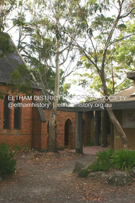 Eltham District Historical Society Inc
Photograph - Digital Photograph, Alan King, St Margaret's Anglican Church, Pitt Street, Eltham, 30 January 2008
... settlers were unusual in initiating the establishment of a church. Usually in Victoria a vicar was appointed to a parish and then a permanent church was constructed. But then, the nearest church was at Heidelberg, which was a tedious and time-consuming journey. St Margaret’s builder was a local, George Stebbing, who also constructed the former Methodist, later Uniting, Church at John Street and the Shillinglaw Cottage near Eltham’s Central Park. ...settlers were unusual in initiating the establishment of a church. Usually in Victoria a vicar was appointed to a parish and then a permanent church was constructed. But then, the nearest church was at Heidelberg, which was a tedious and time-consuming journey. St Margaret’s builder was a local, George Stebbing, who also constructed the former Methodist, later Uniting, Church at John Street and the Shillinglaw Cottage near Eltham’s Central Park. ...St Margaret’s Church of England was officially opened on December 12, 1861. It is the oldest intact church building in Eltham. At the time it was known as Christ Church until its consecration in 1871, when it was completely free of debt (£1,700 for the church and parsonage) despite the district’s poverty. This was largely due to the free labour and materials, including locally made bricks donated by local artisans and others. The church is historically significant because it is the oldest church in the former Shire of Eltham and has associations with the philanthropist and founder of Brighton, Henry Dendy (who donated the land on which the church is built), the architect Nathaniel Billing and the prominent local builder, George Stebbing. The church is architecturally and aesthetically significant because it is constructed in the Gothic Revival style with several stained-glass windows of various dates and is also a very early use of polychromatic brickwork in Victoria. Billing was one of the first Melbourne architects to employ polychromatic brickwork and an important early architect. The rear wall was intended to be temporary. A major feature of the design is the large buttresses with long, steeply graded upper faces. The overall design is well proportioned with the surface brick patterns relieving an otherwise austere design. The church is spiritually and socially significant because it has been an important place of worship for the people of Eltham for almost 150 years. The land on which the buildings stand was donated by Henry Dendy. Dendy arrived in Melbourne in 1841 after purchasing in England eight square miles at Brighton under the system of "special surveys". After this land passed out of his hands, Dendy moved about Victoria, visited England, then returned to settle in Eltham where he purchased a flour mill. Dendy chaired the meeting held in 1860 “for the purpose of devising such means as may be expedient for the establishment of a Church of England in the township of Eltham”. He became chairman and treasurer of the church committee. Unlike the establishment of many early churches in Victoria where a vicar was appointed to a parish and later a permanent church was constructed, the population at Eltham initiated action to build a church. The nearest church at that time was at Heidelberg and the Eltham settlement was part of the parish of St Johns Heidelberg. Isolation and the tedious, time consuming journey between Heidelberg and Eltham resulted in the Eltham community taking its own action. The original vicarage (Dendy House) at the rear of the church is also an important part of the cultural significance of this place because it is connected to the church and the development of the Eltham area. Together, the church and the vicarage are aesthetically significant because they form a significant streetscape feature. The mud-brick community hall designed by Robert Marshall was added in 1978. In 2014 the original temporary rear wall was removed as part of a modern extension designed by Architects Atelier Wagner and constructed by Conrad Construction and Management. Covered under Heritage Overlay, Nillumbik Planning Scheme. National Trust of Australia (Victoria) State significance Victorian Heritage Published: Nillumbik Now and Then / Marguerite Marshall 2008; photographs Alan King with Marguerite Marshall.; p67 St Margaret’s Anglican Church in Pitt Street, Eltham, which officially opened on December 12, 1861, is the oldest intact church building in Eltham.1 With the nearby courthouse and police station, it was one of the first permanent community buildings in the district. The church and vicarage are on the Register of the Heritage Council of Victoria and the National Trust of Australia – Victoria. The church is important as an early example of polychrome brickwork by the notable architect Nathaniel Billings. It is also notable for its historic associations with the early settlement of the Shire of Eltham and its connection with Henry Dendy, Brighton’s founder.2 Henry Dendy, who lived in Eltham much longer than at Brighton, chaired the original meeting which planned the church, and he donated the half-acre (0.2ha) site. Dendy had arrived in Melbourne in 1841 after buying eight square miles (20.7sq km) at Brighton while in England. After this land passed out of his hands, he eventually settled in Eltham where he bought a flour mill, west from the corner of Main Road and Pitt Street (then called Brewery Lane). The vicarage was named Dendy House after him. The Eltham settlers were unusual in initiating the establishment of a church. Usually in Victoria a vicar was appointed to a parish and then a permanent church was constructed. But then, the nearest church was at Heidelberg, which was a tedious and time-consuming journey. St Margaret’s builder was a local, George Stebbing, who also constructed the former Methodist, later Uniting, Church at John Street and the Shillinglaw Cottage near Eltham’s Central Park. It is believed the first Anglican Bishop of Melbourne, Bishop Perry, dedicated the church. After the ceremony he joined in the festivities at the nearby pub and a bill was sent to the parish for teas taken there by the bishop with other participants. The first vicar was the Reverend Robert Mackie from 1864 to1866. St Margaret’s Church was originally called Christ Church until its consecration in 1871, when it was completely free of debt (£1700 pounds for the church and parsonage) despite the district’s poverty. This was largely due to the free labour and materials, including local bricks, donated by local artisans and others. St Margaret’s Church is in the Gothic Revival tradition with a buttressed nave, paired lancet windows, porch and bell-cote. It was the first polychromatic brick church in Australia, using softly contrasting coloured brickwork.3 Billing was one of the first architects to introduce polychrome brickwork into Melbourne. His original drawings for St Margaret’s survive in a folio of his architectural work. However the church’s brickwork is more subdued than in his drawings. About half the windows – those in clear glass with gold borders – are original. The stained glass windows were made much later, but the one behind the altar is thought to be the oldest in the Diamond Valley. It was to be temporary until the congregation could afford to extend the church. In the early 1960s the original cedar pews were replaced by blonde timber pews and the originals were sold to restaurants and to private individuals. Eminent local sculptor Matcham Skipper created a crucifix for the church. A major addition was made in 1978, when the weatherboard hall was replaced by a mud-brick hall. Made of local material, it was designed by local architect and a former shire president Robert Marshall. The mud-brick hall reflects the style of building in Eltham of the late 1970s and for which Eltham is well-known. Perhaps because its earthy tones blend with the surrounding environment, the hall sits well with the church building. St Margaret’s membership has included economist and ABC chairman, Richard Downing; political commentator, diplomat and academic, William Macmahon Ball; Eltham civic leader, Charles Wingrove; artist, Peter Glass; and Eltham’s first postmaster, Frederick Falkiner.This collection of almost 130 photos about places and people within the Shire of Nillumbik, an urban and rural municipality in Melbourne's north, contributes to an understanding of the history of the Shire. Published in 2008 immediately prior to the Black Saturday bushfires of February 7, 2009, it documents sites that were impacted, and in some cases destroyed by the fires. It includes photographs taken especially for the publication, creating a unique time capsule representing the Shire in the early 21st century. It remains the most recent comprehenesive publication devoted to the Shire's history connecting local residents to the past. nillumbik now and then (marshall-king) collection, eltham, st margaret's anglican church, st margaret's church, st margarets church hall, christ church -
 Eltham District Historical Society Inc
Photograph - Digital Photograph, Alan King, Kinglake National Park, 27 March 2008
... Remains of gold shafts and diggings in the park are reminders of Kinglake’s first settlers, who hoped to strike it rich at the gold diggings. ...Remains of gold shafts and diggings in the park are reminders of Kinglake’s first settlers, who hoped to strike it rich at the gold diggings. ...Fern gullies around Jehosaphat Gully Covered under National Estate. Published: Nillumbik Now and Then / Marguerite Marshall 2008; photographs Alan King with Marguerite Marshall.; p125 The magnificent Kinglake National Park, fringing Nillumbik’s north, is the largest national park close to Melbourne. Thanks to the vision and hard work of a band of local people, the park was created from what was rapidly becoming degraded land. Seeing a threat to Kinglake’s indigenous flora and fauna, several prominent local people campaigned for a national park, which was established in 1928.1 Since then, the park has grown through donations and acquisitions of land, from around 13,800 acres of land (5585ha) to 22,360 hectares. The Sugarloaf and Everard Blocks – of almost 8000 hectares – stand in Nillumbik and the park extends into Mitchell and Murrundindi Shires and the City of Whittlesea. Mt Everard commemorates William Hugh Everard, State member for Evelyn when the park was established. Before 1928, European settlers had degraded the Kinglake area, which was named after the celebrated English author and lawyer, Alexander William Kinglake. Remains of gold shafts and diggings in the park are reminders of Kinglake’s first settlers, who hoped to strike it rich at the gold diggings. But like other gold fields in this shire, they proved not very lucrative and soon timber cutting replaced mining in importance. However, before long, the accessible timber supply ran out, so in the 1920s agriculture took over – particularly potatoes and berry fruits – which involved large-scale clearing.2 The park’s instigator was retired Melbourne University Professor of Music, William Laver.3 As chair of the Kinglake Progress Association he began negotiations to have crown lands on the southern scarp of the Great Dividing Range reserved as a national park. Even before the park was proclaimed, from 1927, KPA members cut tracks to the major scenic points. Professor Laver was one of several people who gave land for the park, donating around 50 acres (20ha), including the Jehosaphat Gully.4 Laver chaired the park’s first Committee of Management, which raised money to employ a ranger and provide facilities, including tracks and roads for fire protection vehicles, toilets and shelters. The committee charged fees for firewood collection, some grazing of livestock, and visitor entrance, and obtained small State Government and Eltham Shire grants. In 1957 the State Government provided revenue for national parks. Then, in 1975, the State Government took over the management and the Committee of Management became an advisory committee, which disbanded in 1978. Originally, the park covered crown land in the Shires of Eltham and Whittlesea; then Wombelano Falls in Yea and other areas were added. In 1970 the park extended into the Shires of Eltham, Healesville, Whittlesea and Yea.5 Bush fires have been an ongoing problem. In 1939 hundreds of eucalypts and acacias had to be sown around the Jehosaphat Gully to rejuvenate the forest. To manage bushfires, the Committee of Management, then the State Government, worked closely with the Forestry Commission, shire councils and local fire brigades. Early national parks focussed on recreation. But by the 1980s, conservation, education and scientific research became more important, playing a vital role in preserving representative samples of the natural environment. Each year many thousands of people use the park’s extensive network of walking tracks amongst the protected plant and animal life as well as camping, cycling and horse riding. The park, along the slopes of the Great Dividing Range, has lookouts revealing magnificent views of the Melbourne skyline, Port Phillip Bay, the Yarra Valley and the You Yangs. Vegetation in the Masons Falls area includes messmate forest, Austral grass-trees, ferns and Hazel Pomaderris. In spring, orchids, lilies, everlasting daisies, correas, grevillea and heath appear. Around Jehosaphat Gully are wet and dry forest, fern gullies and banksia. Animal life includes wallabies, kangaroos, koalas, echidnas, possums, gliders and bandicoots. Male lyrebirds can be heard mimicking in the Jehosaphat Gully, particularly in the Everard Block in winter.This collection of almost 130 photos about places and people within the Shire of Nillumbik, an urban and rural municipality in Melbourne's north, contributes to an understanding of the history of the Shire. Published in 2008 immediately prior to the Black Saturday bushfires of February 7, 2009, it documents sites that were impacted, and in some cases destroyed by the fires. It includes photographs taken especially for the publication, creating a unique time capsule representing the Shire in the early 21st century. It remains the most recent comprehenesive publication devoted to the Shire's history connecting local residents to the past. nillumbik now and then (marshall-king) collection, kinglake national park, jehosaphat gully -
 The Beechworth Burke Museum
Animal specimen - Eastern Rosella, Trustees of the Australian Museum, 1860-1880
... These birds are often found in urban habitats such as parks, gardens and golf courses. Early European settlers encountered the Eastern Rosella at Rose Hill, New South Wales, now Parramatta, and so they called it the Rosehill parakeet which became "Rosehiller", and eventually shortened to "rosella". ...These birds are often found in urban habitats such as parks, gardens and golf courses. Early European settlers encountered the Eastern Rosella at Rose Hill, New South Wales, now Parramatta, and so they called it the Rosehill parakeet which became "Rosehiller", and eventually shortened to "rosella". ...Eastern Rosellas are multi-coloured medium-sized Australian parrots with distinctive white cheek patches. The Eastern Rosella is found throughout south-eastern Australia, from Queensland to Victoria, south-eastern South Australia, and eastern Tasmania. Despite their vibrant colours, Rosellas camouflage well into their surroundings when perching or when on the ground. The Eastern Rosella is found in open woodlands, grasslands, farmlands and remnant bushland. These birds are often found in urban habitats such as parks, gardens and golf courses. Early European settlers encountered the Eastern Rosella at Rose Hill, New South Wales, now Parramatta, and so they called it the Rosehill parakeet which became "Rosehiller", and eventually shortened to "rosella". This specimen is part of a collection of almost 200 animal specimens that were originally acquired as skins from various institutions across Australia, including the Australian Museum in Sydney and the National Museum of Victoria (known as Museums Victoria since 1983), as well as individuals such as amateur anthropologist Reynell Eveleigh Johns between 1860-1880. These skins were then mounted by members of the Burke Museum Committee and put-on display in the formal space of the Museum’s original exhibition hall where they continue to be on display. This display of taxidermy mounts initially served to instruct visitors to the Burke Museum of the natural world around them, today it serves as an insight into the collecting habits of the 19th century.This specimen is part of a significant and rare taxidermy mount collection in the Burke Museum. This collection is scientifically and culturally important for reminding us of how science continues to shape our understanding of the modern world. They demonstrate a capacity to hold evidence of how Australia’s fauna history existed in the past and are potentially important for future environmental research. This collection continues to be on display in the Museum and has become a key part to interpreting the collecting habits of the 19th century. This mature Eastern Rosella has a red head and breast, with a light green belly and distinctive white cheeks. The back is yellow-green with black mottling, the yellow-green turning green then to blue across the wings. The tail feathers are blue/black, with a red base on the underside. This specimen stands upon a wooden platform and has an identification tag tied around its leg.Label: 79/ Rose-hill Parakeet / See catalogue, page 22 taxidermy mount, taxidermy, animalia, burke museum, beechworth, australian museum, skin, reynell eveleigh johns, bird, australian birds, rosella, eastern rosella, rosehill parakeet, rose-hill parakeet