Showing 186 items matching "soil use"
-
 Tatura Irrigation & Wartime Camps Museum
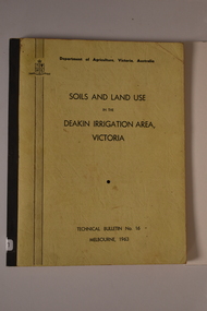
Book, Soils and Land Use. Deakin Irrigation Area Technical Bulletin No 16, 1963
... ...soil use...Information in regard to land and soil use in Deakin irrigation area....Tatura Irrigation & Wartime Camps Museum 49 Hogan Street Tatura the-murray Information in regard to land and soil use in Deakin irrigation area. land use soil use Deakin irrigation area Mid sized soft cover book, black spine, off white front and back, black writing on back and front Soils and Land Use. ...Mid sized soft cover book, black spine, off white front and back, black writing on back and frontnon-fictionland use, soil use, deakin irrigation area -
 Tatura Irrigation & Wartime Camps Museum
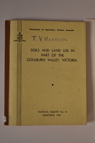
Book, Department of Agriculture Victori, Soil and Land Use in Part of the Goulburn Valley Victoria Technical Bulletin No 14, 1962
... Soil and Land Use in Part of the Goulburn Valley Victoria Technical Bulletin No 14...Tech Bulletin No 14. Soil and Land Use in Part of the Goulburn Valley Victoria Technical Bulletin No 14 Book Book Department of Agriculture Victori ...Mid sized book with soft cover, brown spine with off white cover. Black writing on back and front. Contains maps. Tech Bulletin No 14.non-fictiongoulburn valley, soil studies victoria, victorian maps -
 Kiewa Valley Historical Society
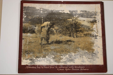
Photo - Kiewa Hydro Electric Scheme - Soil Conservation, Official S.E.C.V. photos
... Soil Conservation used on banks of the Racelines on the Bogong High Plains near Falls Creek....Kiewa Valley Historical Society Mount Beauty Information Centre 31 Bogong High Plains Rd Mt Beauty high-country Soil Conservation used on banks of the Racelines on the Bogong High Plains near Falls Creek. ...Soil Conservation used on banks of the Racelines on the Bogong High Plains near Falls Creek. -
 Warrnambool and District Historical Society Inc.
Archive (collection) - Elmac Hydroponics business material, Elmac Hydroponics, 2004
... It was owned and operated by Keith and Leonie Ellerton and Graeme and Barbara McLeod and produced mainly hydroponic tomatoes (grown without soil using a nutrient solution). The business had a 2000 square metres greenhouse with 10,000 tomato plants....It was owned and operated by Keith and Leonie Ellerton and Graeme and Barbara McLeod and produced mainly hydroponic tomatoes (grown without soil using a nutrient solution). The business had a 2000 square metres greenhouse with 10,000 tomato plants. ...Business owners collectionCollected for archival reasonsMaterial in foldernewspaper cuttings, certificates, photographs, articles re the business operationswestern district industries, warrnambool, elmac hydroponicswestern district industries, warrnambool, elmac hydroponics -
 Tatura Irrigation & Wartime Camps Museum
Book, Soils and Land Use, 1963
... Advice to land holders on how to use the Soil Survey Report. Soils and land use in the deakin Irrigation area, Vict, Technical Bulletin No. 16, Melb. ...Includes maps for Deakin Irrigation Area soils and land use tatura irrigation books technical rural industry Cream cover, black writing, Techical Bulletin No. 16 Soils and Land Use Book ...Advice to land holders on how to use the Soil Survey Report. Soils and land use in the deakin Irrigation area, Vict, Technical Bulletin No. 16, Melb. Includes maps for Deakin Irrigation AreaCream cover, black writing, Techical Bulletin No. 16soils and land use, tatura, irrigation, books, technical, rural, industry -
 Warrnambool and District Historical Society Inc.
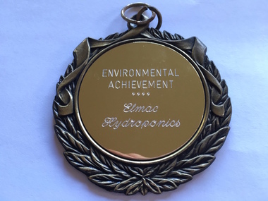
Medallion, Trophy Environmental achievement, 2000
... Hydroponics is a system of growing plants without soil, using a nutrient solution. Elmac Hydroponics had a 2,000 square metre greenhouse with 10,000 growing points. ...Hydroponics is a system of growing plants without soil, using a nutrient solution. Elmac Hydroponics had a 2,000 square metre greenhouse with 10,000 growing points. ...This is a medallion awarded in 2000 by Powercor Warrnambool to Elmac Hydroponics. Powercor Australia, founded in 1994, is an electrical distribution company operating in the Western District of Victoria and the western suburbs of Melbourne. Powercor Warrnambool, like other Powercor organizations, is involved in giving Business Excellence Awards annually to businesses in its area of supply. In 2014 there were 15 awards for Business Excellence. Elmac Hydroponics was a business growing and supplying organically-produced tomatoes from 1997 to 2004. It was situated at Mount Pleasant, Princes Highway, Allansford, Victoria. The business was operated by Graeme and Barbara McLeod and Keith and Leonie Ellerton. Hydroponics is a system of growing plants without soil, using a nutrient solution. Elmac Hydroponics had a 2,000 square metre greenhouse with 10,000 growing points. This is a significant medallion, showing the award given to a small business in the Warrnambool area and indicating its achievements in the environmental area. Elmac was an industry leader in in implementing an ‘Autopot’ hydroponic system which is aimed at reducing nutrient and waste water to zero. Elmac was also a finalist in the Ericsson 2002 Innovation Awards.This is a gilt metal medallion, oval-shaped, with an ornamental edging and a shield-shaped design on one side and a circular design on the other. The top has two metal rings for attachment to a chain or wall hook. On one side: ‘Environmental Achievement, Elmac Hydroponics’ On obverse side: ‘Powercor Warrnambool Region Business Achievement Awards, 2000’ elmac hydroponics, powercor business awards, warrnambool -
 Whitehorse Historical Society Inc.
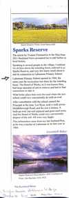
Article, Sparks Reserve, Nov/Dec 2021
... The Board of Works established a retarding basin known as Sparks Reserve in 1964 opposite Laburnum Primary School and needed to remove soil which was used to create a school oval....Whitehorse Historical Society Inc. 2-10 Deep Creek Road Mitcham melbourne The Board of Works established a retarding basin known as Sparks Reserve in 1964 opposite Laburnum Primary School and needed to remove soil which was used to create a school oval. The soil removed from Sparks Reserve Retarding Basin created an oval at Laburnum Primary School Sparks Reserve Retarding Basin Laburnum Primary School No 4863 Fitzmaurice Yvonne Baker Gwennyth An article about Sparks Reserve Retarding Basin and Laburnum Primary School oval Sparks Reserve Article The Buckland News. ...An article about Sparks Reserve Retarding Basin and Laburnum Primary School ovalnon-fictionAn article about Sparks Reserve Retarding Basin and Laburnum Primary School ovalsparks reserve, retarding basin, laburnum primary school no 4863, fitzmaurice yvonne, baker gwennyth -
 Greensborough Historical Society
Photograph - Digital Image, Art at WaterMarc, July 2017, 22/07/2017
... This area's exceptionally fertile soil [used by] by white settlers for farms, market gardens and orchards reshaped the Wurundjeri's traditional lands - and today the private sale and division of these farms informs the streetscape and town plan. ...This area's exceptionally fertile soil [used by] by white settlers for farms, market gardens and orchards reshaped the Wurundjeri's traditional lands - and today the private sale and division of these farms informs the streetscape and town plan. ...Photographs of an art installation by Jessie Stanley at WaterMarc Greensborough on 22/07/2017. From Jessie Stanley's FaceBook page :Dust to Dust is complete... It's an ephemeral site-specific work about how the Melbourne suburb of Greensborough has transformed over time. This area's exceptionally fertile soil [used by] by white settlers for farms, market gardens and orchards reshaped the Wurundjeri's traditional lands - and today the private sale and division of these farms informs the streetscape and town plan. With soil sourced locally this work reveals some of the area’s history - the text running around the perimeter was written by former resident Val Wilson, a snippet of her recollections of growing up in the area in the 1950s. The arrows and text act like a compass to orientate this site with greater Melbourne. On display in the lobby of Banyule Council until chance, time (or a broom) sweeps it away, Many thanks to Banyule City Council, Greensborough Historical Society and Valerie Wilson. "An artistic representation of Greensborough's history.Digital photographs of art installation.jessie stanley, watermarc, greensborough historical society, banyule council -
 Eltham District Historical Society Inc
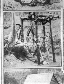
Negative - Photograph, The Leader, An Old-Timer and his Old-Time Blower, 2 Nov. 1929
... A gold miner with his home made dry blower device used for extracting gold particles from dry soil with out the use of water. ...A gold miner with his home made dry blower device used for extracting gold particles from dry soil with out the use of water. ...Queenstown (St. Andrews) District. A gold miner with his home made dry blower device used for extracting gold particles from dry soil with out the use of water. In 1929, St Andrews was known as Queenstown. Originally published in The Leader, Nov. 2nd, 1929, with the title "Relics of the Old Mining days in the Queenstown District," a series of eight numbered photographs. 'The Leader'; a weekly journal of news, politics, agriculture, literature, science and sport.This photo forms part of a collection of photographs gathered by the Shire of Eltham for their centenary project book,"Pioneers and Painters: 100 years of the Shire of Eltham" by Alan Marshall (1971). The collection of over 500 images is held in partnership between Eltham District Historical Society and Yarra Plenty Regional Library (Eltham Library) and is now formally known as 'The Shire of Eltham Pioneers Photograph Collection.' It is significant in being the first community sourced collection representing the places and people of the Shire's first one hundred years.Digital image 4 x 5 inch B&W Neg Print 11 x 24.5 cmsepp, shire of eltham pioneers photograph collection, queenstown, gold mining, gold miner, st. andrews, old timer -
 Puffing Billy Railway
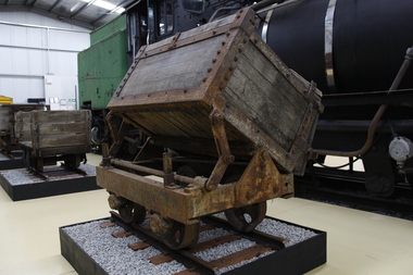
Side Tipping Timber Skip, circa 1900?
... Gauge 17 inch (430mm) Typical of the many side tipping wagons used for soil and rock disposal in construction work and mining throughout Australia and the world. ...Gauge 17 inch (430mm) Typical of the many side tipping wagons used for soil and rock disposal in construction work and mining throughout Australia and the world. ...Side Tipping Timber Skip Wooden Contractors Wagon. Gauge 17 inch (430mm) Typical of the many side tipping wagons used for soil and rock disposal in construction work and mining throughout Australia and the world. The wagon would be loaded with soil and pushed along a short line to the end of track where the load would be emptied out to either side. By using a central pivot the wagon’s body can be tipped either side to allow the contents to be easily removed ready for the next load.Historic - Industrial Narrow Gauge RailwayWooden bodied, steel framed side tipping skip.puffing billy, side tipping skip, industrial narrow gauge railway -
 Warrnambool and District Historical Society Inc.
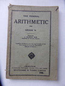
Book, The Federal Arithmetic, Early 20th century
... used early in the 20th century. bonnett family mepunga allans forest state school warrnambool history ‘George H. Bonnett, Allans Forest State School’ This is soft cover book of 128 pages. The cover is grey with black print and black lines around the edges of the front cover. The book has a prefatory note, arithmetical exercises and advertisements for other school text books published by Whitcombe and Tombs. The cover is torn and soiled ...This is a Grade V Arithmetic book used by George Bonnett at Allans Forest School. The Bonnett family farmed in the Mepunga area on the Childers Cove Road. The Allans Forest State School, number 1086, was established in 1871 and closed in 1993. The first Head Teacher was Mr Bradhurst. The school closed in 1903 and re-opened in 1905 as a half-time school with Mepunga East and in 1908 it resumed as a full time school. This book is significant because it was used by George Bonnett at the Allans Forest State School and is a memento of both the Bonnett family of Mepunga and the Allans Forest State School, a school no longer existing. It is also of antiquarian interest as an example of arithmetic school text books used early in the 20th century. This is soft cover book of 128 pages. The cover is grey with black print and black lines around the edges of the front cover. The book has a prefatory note, arithmetical exercises and advertisements for other school text books published by Whitcombe and Tombs. The cover is torn and soiled and partly ripped away. There is handwriting in black ink on the first page.‘George H. Bonnett, Allans Forest State School’bonnett family, mepunga, allans forest state school, warrnambool history -
 Warrnambool and District Historical Society Inc.
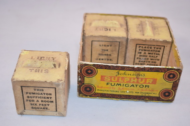
Household item, Sulphur Fumigator Cubes (boxed), Early 20th century
... These sulphur fumigator cubes were used in the past to fumigate areas in such places as hospitals, plant nurseries, farms and homes. The cube was placed in a tin containing soil and the top wick was set alight and the cube would burn overnight and kill off insects, mites and germs. ...Warrnambool and District Historical Society Inc. 2 Gilles Street (south of Merri St) Warrnambool great-ocean-road These sulphur fumigator cubes were used in the past to fumigate areas in such places as hospitals, plant nurseries, farms and homes. The cube was placed in a tin containing soil and the top wick was set alight and the cube would burn overnight and kill off insects, mites and germs. ...These sulphur fumigator cubes were used in the past to fumigate areas in such places as hospitals, plant nurseries, farms and homes. The cube was placed in a tin containing soil and the top wick was set alight and the cube would burn overnight and kill off insects, mites and germs. One cube was sufficient for a room six feet square. This is a square cardboard box with no lid. The box is brown with orange, red and black printing. The box contains three cubes of sulphur fumigators. There should be four but one cube is missing. The cubes are square-shaped with beige-coloured sides and yellow tops. The tops have raised sections which serve as wicks. ‘Light This’ ‘Johnson’s Sulphur Fumigator prepared by Johnson & Johnson, Manufacturing Chemists’ household items, history of warrnambool -
 Warrnambool and District Historical Society Inc.
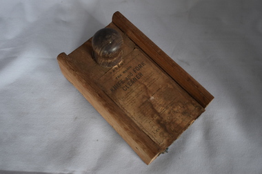
Functional object - Knife and fork cleaner, Levin & Co Pty Ltd, Early 20th century
... used, To clean knives and forks brightly I never refuse, In mansion or cottage to both I do go, So buy me, and try me, my worth you will know.’ This is a circular wooden box with an extra piece at one end of the base and a sliding top lid with a wooden knob. The lid lifts up and the inside of the box and the lid is covered with rough cloth. Some of this cloth has rotted away. The top of the lid has a printed label pasted on. This is torn and soiled ...This is a simple household labour-saving device. The box was fitted to the end of the table and knife polish was sprinkled on the cloth inside. The knife was then placed in the centre of the box and clamped in tightly. The knife was then pulled backwards and forwards several times (three seconds was the suggested time) and the object was then deemed to be polished. All households had cutlery of some sort and many had good silver pieces that were meant to be kept in a sparkling polished condition. This cleaner would have assisted those in a household assigned to the care of the cutlery. These would have included the women of the household, the children or domestic employees. This item is retained as an interesting example of a household labour-saving device from 100 years ago. This is a circular wooden box with an extra piece at one end of the base and a sliding top lid with a wooden knob. The lid lifts up and the inside of the box and the lid is covered with rough cloth. Some of this cloth has rotted away. The top of the lid has a printed label pasted on. This is torn and soiled. ‘Patent The Magic Knife and Fork Cleaner’ ‘I am handy and useful where’r I am used, To clean knives and forks brightly I never refuse, In mansion or cottage to both I do go, So buy me, and try me, my worth you will know.’ household devices, history of warrnambool -
 Warrnambool and District Historical Society Inc.
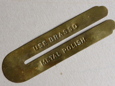
Button Protector, Button Cleaning, Early 20th century
... used to cover the shirts or jackets of military or other uniforms that had brass buttons. The horseshoe shape enabled the button to be isolated from the rest of the top and made it easier to clean and polish without getting the jacket soiled. ...used to cover the shirts or jackets of military or other uniforms that had brass buttons. The horseshoe shape enabled the button to be isolated from the rest of the top and made it easier to clean and polish without getting the jacket soiled. ...This is a protector used to cover the shirts or jackets of military or other uniforms that had brass buttons. The horseshoe shape enabled the button to be isolated from the rest of the top and made it easier to clean and polish without getting the jacket soiled. It would have been a common item in military or militia or band member families in the 19th and early 20th centuries. They may even be still used today for regimental uniforms. This item has no known local provenance but is of interest as an example of a cleaning object in days gone by. This is a brass button protector in the shape of a horseshoe with straight sides and rounded tips. It is slightly misshapen. It has an advertisement for Brasso metal polish etched into the brass. ‘Use Brasso Metal Polish’button cleaner/protector, brass, warrnambool, military -
 Bendigo Military Museum
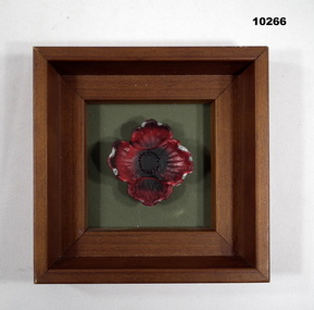
Souvenir - FRAMED ITEM, POPPY, Ron Davis
... used by Light Horse Brigade and Voluntary Defence Corps dating back to 1906. Part of the collection of Kevin John Herdman, No. 397661. See Cat No. 5942P for details of his service. Framed Item Poppy Souvenir Kevin John HERDMAN Text on back in black type: "Fired from a rifle or gun, they sound, Fly through the air, some fall to the ground, covered in soil and grass they lay, 100 years we remember our heroes this day, Now rise the bullet recycled from the past, A beautiful poppy that will ever last" by Ron Davis, www leadastray.com.au 3D red poppy in a brown wooden frame. ...Poppy was made from lead bullets collected from historical Rifle Range used by Light Horse Brigade and Voluntary Defence Corps dating back to 1906. Part of the collection of Kevin John Herdman, No. 397661. See Cat No. 5942P for details of his service.3D red poppy in a brown wooden frame. Poppy sits in a khaki coloured background. Poppy fabricated from lead. Provenance details on back with text in black type.Text on back in black type: "Fired from a rifle or gun, they sound, Fly through the air, some fall to the ground, covered in soil and grass they lay, 100 years we remember our heroes this day, Now rise the bullet recycled from the past, A beautiful poppy that will ever last" by Ron Davis, www leadastray.com.auframed item, poppy, souvenir, kevin john herdman -
 Kiewa Valley Historical Society
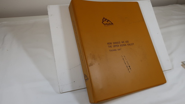
Folder - Upper Kiewa Valley, How Should We Use the Upper Kiewa Valley by J. R. Anderson, Education Officer
... Soil Conservation Authority. Published Nov. 1979 The folder also includes 17 colored slides held at the front by a clear plastic pocket. How Should We Use ...A mustard plastic folder with four steel rings holding many white pages printed on one side only. Written by J. R. Anderson, Education Officer for the Soil Conservation Authority. Published Nov. 1979 The folder also includes 17 colored slides held at the front by a clear plastic pocket.soil conservation authority, upper kiewa valley, j. r. anderson, education for seniors -
Kiewa Valley Historical Society
Safety Helmet - SECV
... used by workers on the Kiewa Hydro Electric Scheme. While working at McKay Creek Power Station, Alec Menzies was hit on the head with a rock and fell about 10 metres. Luckily he survived, and after a stint in hospital he was admitted to what was known as the Turtle Club. Ref. Mal Menzies, his son. safety helmet McKay Creek Power Station Alec Menzies Turtle Club Centre front - a sticker - "Member/ Turtle Club. Inside: embossed an oval shape with 'hard/soiled ...Safety helmets were used by workers on the Kiewa Hydro Electric Scheme.While working at McKay Creek Power Station, Alec Menzies was hit on the head with a rock and fell about 10 metres. Luckily he survived, and after a stint in hospital he was admitted to what was known as the Turtle Club. Ref. Mal Menzies, his son.Cream coloured safety helmet with 3 ridges at the top from back to front. It is light in weight. Inside has an attached cloth band with 'netting' of 6 straps attached to band and an inner band. Underneath the shade, at the front, it is coloured green.Centre front - a sticker - "Member/ Turtle Club. Inside: embossed an oval shape with 'hard/soiled' in its middle and underneath also embossed E.D. Bullard Co. / S.F. U.S.A.safety helmet, mckay creek power station, alec menzies, turtle club -
 Kiewa Valley Historical Society
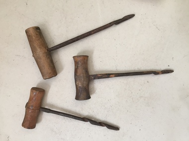
Tools - Hand Augers - small x3
... Used for digging more shallow holes eg. gathering soil samples and making post holes ...Used for digging more shallow holes eg. gathering soil samples and making post holes Tools - Hand Augers - small x3 ...Used by turning the auger around to create a round hole.Used by residents of the Kiewa ValleySmall steel hand auger tools with a wooden handle. Used for digging more shallow holes eg. gathering soil samples and making post holes -
 Kiewa Valley Historical Society
Ploughshare
... soil before sowing seed or planting. Ploughs were drawn by oxen and horses. Now drawn by tractors. Farmers in the Kiewa Valley used ploughs before tractors became available. ploughshare agriculture farming crops Formerly KV 060. ...The ploughshare cuts grass and soil loosening or turning the soil before sowing seed or planting. Ploughs were drawn by oxen and horses. Now drawn by tractors.Farmers in the Kiewa Valley used ploughs before tractors became available.Formerly KV 060. Made of steel and a component of a plough. It is the cutting or leading edge of a mouldboard which closely follows the coulter wen ploughing. Attached picture shows the ploughshare as part of a plough. Ref. Farmyard Relics by Ken Arnold Page 49ploughshare, agriculture, farming crops -
 Kiewa Valley Historical Society
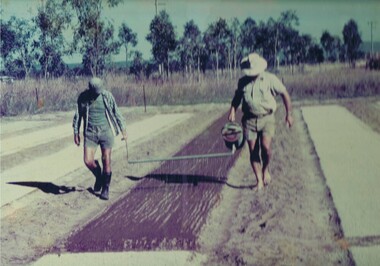
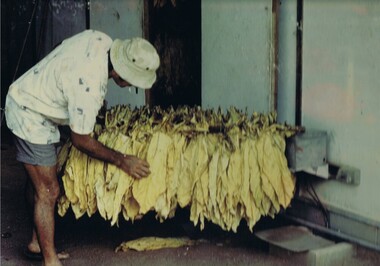
Photograph Tobacco planting, Planting Tobacco seeding, Circa mid to late 1900's
... soil of farmlands in the region, still remains a problem now and for future generations. This particular photograph shows the lack of understanding by farmers and the contracted labour, at that time, and is demonstrated by the bare footed farmer walking next to the seed canister. Some workers did use ...This promotional photograph by the Tobacco Growers Association was in response to a 1935 meeting of tobacco growers from Victoria, South Australia and Queensland which produced four major resolutions for the industry covering the remainder of the 1900s. These four resolutions were: (1) Adequate tariff protection (2) Control of pests and diseases (3) Orderly marketing (4) The formation of an advisory council of growers. History has produced the following results. (1) adequate tariff protection was never achieved,(2) control of disease through benzol vapour (CSIRO) breakthrough, was later identified as carcinogenic, (3) orderly marketing was achieved through (4) the establishment of the Tobacco Growers Association(1984). In October 2006, by way of Government buy back of tobacco leases from growers, resulted in the end of Tobacco farming in Australia (after 136 years of planting the first crop). It was also significant that the major tobacco companies such as Philip Morris and The British American Tobacco Australasia advised the industry that it would source its tobacco requirements overseas by 2009.The remnants of the Tobacco Industry can still be viewed throughout the Kiewa Valley and adjacent regions on the former tobacco farms which still have the tobacco drying sheds and now converted into hay sheds. The problems from the large quantities of carcinogenic infused soil of farmlands in the region, still remains a problem now and for future generations. This particular photograph shows the lack of understanding by farmers and the contracted labour, at that time, and is demonstrated by the bare footed farmer walking next to the seed canister. Some workers did use protective "gum" boots but the majority of farm owners were skeptical of city scientists and their carcinogenic concerns, and it was only after the younger generation of farmers , who had attended Agricultural colleges, encompassed the scientific approach to farm management and began working closely with agricultural scientists. The "she'll be right mate" attitude of the earlier farming/rural community has since mid 1970s, been slowly dissipating. Stricter controls of herbicides and pesticides used in agriculture are now in force. The death of the tobacco industry(2006) resulted in the expansion of the dairy , sheep, beef cattle, venison and lama wool producers in the Kiewa Valley and surrounding regions.Coloured photograph pasted onto a thick wood chip backing. Two galvanised eyelets at the top of the frame, 50mm from each end, with a twine cord stretch from each, for hanging purposes. See also KVHS 0054(B) to KVHS 0054(F)A sign, which has been removed from the picture at some previous point in time is "The Tobacco seed, being so fine, is suspended in water and sown onto the seed base using a watering can [as in the photo] or similar device - August - Sept."tobacco, farming, rural industry, licences, ollie mould, blue mould, benzol vapour -
 Kiewa Valley Historical Society
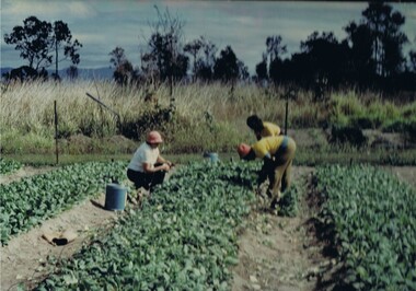
Photograph Tobacco seedlings, Pulling tobacco seedlings for Planting, Circa mid to late 1900s
... This particular photograph shows the lack of understanding by farmers and the contracted labour, at that time, and is demonstrated by the lack of protection of hands when handling seedlings and attached soil. Hand and foot protection was rarely used, even when later warnings were issued of the carcinogenic toxicity of the soil. ...This promotional photograph by the Tobacco Growers Association was in response to a 1935 meeting of tobacco growers from Victoria, South Australia and Queensland which produced four major resolutions for the industry covering the remainder of the 1900s. These four resolutions were: (1) Adequate tariff protection (2) Control of pests and diseases (3) Orderly marketing (4) The formation of an advisory council of growers. History has produced the following results. (1) adequate tariff protection was never achieved,(2) control of disease through benzol vapour (CSIRO) breakthrough, was later identified as carcinogenic, (3) orderly marketing was achieved through (4) the establishment of the Tobacco Growers Association(19840. In October 2006, by way of Government buy back of tobacco leases from growers, resulted in the end of Tobacco farming in Australia (after 136 years of planting the first crop). It was also significant that the major tobacco companies such as Philip Morris and The British American Tobacco Australasia advised the industry that it would source its tobacco requirements overseas by 2009.The death of the tobacco industry(2006) resulted in the expansion of the dairy , sheep, beef cattle, venison and lama wool producers in the Kiewa Valley and surrounding regions. The remnants of the Tobacco Industry can still be viewed throughout the Kiewa Valley and adjacent regions on the former tobacco farms which still have the tobacco drying sheds and now converted into hay sheds. The problems from the large quantities of carcinogenic infused soil of farmlands in the region, still remains a problem now and for future generations. This particular photograph shows the lack of understanding by farmers and the contracted labour, at that time, and is demonstrated by the lack of protection of hands when handling seedlings and attached soil. Hand and foot protection was rarely used, even when later warnings were issued of the carcinogenic toxicity of the soil. The majority of farm owners, up until Health authorities stepped in the later stages of 1900s, were skeptical of city scientists' "carcinogenic" health warnings and it was only after the younger generation of farmers, who had graduated from Agricultural colleges, encompassed the scientific approach to farm management. The "she'll be right mate" attitude of the farming/rural community has since the 1970s been slowly dissipating. Stricter controls of herbicides and pesticides used in agriculture are now in force.Coloured photograph pasted onto a thick wood chip backing. Two galvanised eyelets at the top of the frame, 50mm from each end, with a twine cord stretch from each, for hanging purposes. See also KVHS 0054A, KVHS0054C to KVHS 0054FA sign, which has been removed from the picture at some previous point in time is "Pulling seedlings for planting"tobacco, farming, rural industry, licences, ollie mould, blue mould, benzol vapour, photograph -
 Kiewa Valley Historical Society
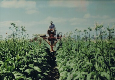
Photograph Topping Tobacco, Tobacco being topped (removal of flower), Circa mid to late 1900's
... This particular photograph shows the lack of understanding by farmers and the contracted labour, at that time, and is demonstrated by the lack of protection of hands when handling seedlings and attached soil. Hand and foot protection was rarely used, even when later warnings were issued of the carcinogenic toxicity of the soil. ...This promotional photograph by the Tobacco Growers Association was in response to a 1935 meeting of tobacco growers from Victoria, South Australia and Queensland which produced four major resolutions for the industry covering the remainder of the 1900s. These four resolutions were: (1) Adequate tariff protection (2) Control of pests and diseases (3) Orderly marketing (4) The formation of an advisory council of growers. History has produced the following results. (1) adequate tariff protection was never achieved,(2) control of disease through benzol vapour (CSIRO) breakthrough, was later identified as carcinogenic, (3) orderly marketing was achieved through (4) the establishment of the Tobacco Growers Association(1984). In October 2006, by way of Government buy back of tobacco leases from growers, resulted in the end of Tobacco farming in Australia (after 136 years of planting the first crop). It was also significant that the major tobacco companies such as Philip Morris and The British American Tobacco Australasia advised the industry that it would source its tobacco requirements overseas by 2009.The remnants of the Tobacco Industry can still be viewed throughout the Kiewa Valley and adjacent regions on the former tobacco farms which still have the tobacco drying sheds and now converted into hay sheds. The problems from the large quantities of carcinogenic infused soil of farmlands in the region, still remains a problem now and for future generations. This particular photograph shows the lack of understanding by farmers and the contracted labour, at that time, and is demonstrated by the lack of protection of hands when handling seedlings and attached soil. Hand and foot protection was rarely used, even when later warnings were issued of the carcinogenic toxicity of the soil. The majority of farm owners, up until Health authorities stepped in the latter stages of 1900s, were skeptical of city scientists' "carcinogenic" health warnings and it was only after the younger generation of farmers, who had graduated from Agricultural colleges, encompassed the scientific approach to farm management. The "she'll be right mate" attitude of the farming/rural community has since the 1970s been slowly dissipating. Stricter controls of herbicides and pesticides used in agriculture are now in force. The death of the tobacco industry(2006) resulted in the expansion of the dairy , sheep, beef cattle, venison and lama wool producers in the Kiewa Valley and surrounding regions.Coloured photograph pasted onto a thick wood chip backing. Two galvanised eyelets at the top of the frame, 50mm from each end, with a twine cord stretch from each, for hanging purposes. See also KVHS 0054A ,KVHS 0054B and KVHC 0054D to KVHS 0054F A sign, which has been removed from the picture at some previous point in time is "The Tobacco crop being topped (flower removed)". tobacco, farming, rural industry, licences, ollie mould, blue mould, benzol vapour -
 Kiewa Valley Historical Society
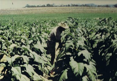
Photograph Tobacco plants, Tobacco fully grown prior to start picking, Circa mid to late 1900's
... soil of farmlands in the region, still remains a problem now and for future generations. This particular photograph shows the lack of understanding by farmers, at that time, and is demonstrated by the lack of protection of hands and no masks over their noses, when handling plants. Hand, nose and foot protection was rarely used ...This promotional photograph by the Tobacco Growers Association was in response to a 1935 meeting of tobacco growers from Victoria, South Australia and Queensland which produced four major resolutions for the industry covering the remainder of the 1900s. These four resolutions were: (1) Adequate tariff protection (2) Control of pests and diseases (3) Orderly marketing (4) The formation of an advisory council of growers. History has produced the following results. (1) adequate tariff protection was never achieved,(2) control of disease through benzol vapour (CSIRO) breakthrough, was later identified as carcinogenic, (3) orderly marketing was achieved through (4) the establishment of the Tobacco Growers Association(1984). In October 2006, by way of Government buy back of tobacco leases from growers, resulted in the end of Tobacco farming in Australia (after 136 years of planting the first crop). It was also significant that the major tobacco companies such as Philip Morris and The British American Tobacco Australasia advised the industry that it would source its tobacco requirements overseas by 2009.The remnants of the Tobacco Industry can still be viewed throughout the Kiewa Valley and adjacent regions on the former tobacco farms which still have the tobacco drying sheds and now converted into hay sheds. The problems from the large quantities of carcinogenic infused soil of farmlands in the region, still remains a problem now and for future generations. This particular photograph shows the lack of understanding by farmers, at that time, and is demonstrated by the lack of protection of hands and no masks over their noses, when handling plants. Hand, nose and foot protection was rarely used, even when later warnings were issued of the carcinogenic toxicity of the soil. The majority of farm owners, up until Health authorities stepped in the latter stages of 1900s, were skeptical of city scientists' "carcinogenic" health warnings and it was only after the younger generation of farmers, who had graduated from Agricultural colleges, encompassed the scientific approach to farm management. The "she'll be right mate" attitude of the farming/rural community has since the 1970s been slowly dissipating. Stricter controls of herbicides and pesticides used in agriculture are now in force. The death of the tobacco industry(2006) resulted in the expansion of the dairy , sheep, beef cattle, venison and lama wool producers in the Kiewa Valley and surrounding regions.Coloured photograph pasted onto a thick wood chip backing. Two galvanised eyelets at the top of the frame, 50mm from each end, with a twine cord stretch from each, for hanging purposes. See also KVHS 0054A to KVHS 0054C and 0054E to KVHS 0054FA sign, which has been removed from the picture at some previous point in time is "The Tobacco fully grown prior to start picking"tobacco, farming, rural industry, licences, ollie mould, blue mould, benzol vapour -
 Kiewa Valley Historical Society
Photograph Tobacco drying leaves, Inspecting Drying tobacco leaves, 1950's to 1999
... soil of farmlands in the region, still remains a problem now and for future generations. This particular photograph shows the lack of understanding by farmers and the contracted labour, at that time, and is demonstrated by the lack of protection of hands when handling the tobacco leaves and nose from tobacco dust. Hand and foot protection was rarely used ...This promotional photograph by the Tobacco Growers Association was in response to a 1935 meeting of tobacco growers from Victoria, South Australia and Queensland which produced four major resolutions for the industry covering the remainder of the 1900s. These four resolutions were: (1) Adequate tariff protection (2) Control of pests and diseases (3) Orderly marketing (4) The formation of an advisory council of growers. History has produced the following results. (1) adequate tariff protection was never achieved,(2) control of disease through benzol vapour (CSIRO) breakthrough, was later identified as carcinogenic, (3) orderly marketing was achieved through (4) the establishment of the Tobacco Growers Association(19840. In October 2006, by way of Government buy back of tobacco leases from growers, resulted in the end of Tobacco farming in Australia (after 136 years of planting the first crop). It was also significant that the major tobacco companies such as Philip Morris and The British American Tobacco Australasia advised the industry that it would source its tobacco requirements overseas by 2009.The remnants of the Tobacco Industry can still be viewed throughout the Kiewa Valley and adjacent regions on the former tobacco farms which still have the tobacco drying sheds and now converted into hay sheds. The problems from the large quantities of carcinogenic infused soil of farmlands in the region, still remains a problem now and for future generations. This particular photograph shows the lack of understanding by farmers and the contracted labour, at that time, and is demonstrated by the lack of protection of hands when handling the tobacco leaves and nose from tobacco dust. Hand and foot protection was rarely used, even when later warnings were issued of the carcinogenic toxicity of the soil. The majority of farm owners, up until Health authorities stepped in the later stages of 1900s, were skeptical of city scientists' "carcinogenic" health warnings and it was only after the younger generation of farmers, who had graduated from Agricultural colleges, encompassed the scientific approach to farm management. The "she'll be right mate" attitude of the farming/rural community has since the 1970s been slowly dissipating. Stricter controls of herbicides and pesticides used in agriculture are now in force. The death of the tobacco industry(2006) resulted in the expansion of the dairy , sheep, beef cattle, venison and lama wool producers in the Kiewa Valley and surrounding regions.Coloured photograph pasted onto a thick wood chip backing. Two galvanised eyelets at the top of the frame, 50mm from each end, with a twine cord stretch from each, for hanging purposes. See also KVHS 0054A to KVHS 0054D and KVHS 0054Ftobacco, farming, rural industry, licences, ollie mould, blue mould, benzol vapour, photograph -
 Kiewa Valley Historical Society
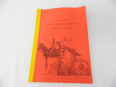
Book - Non Fiction History, Honour Roll - South Africa 1899 - 1902 Albury-Wodonga and District Residents Who Served In The Boer War, reprinted 03/2008
... soil. This Honour Roll details the pay rates, the battle highlights, weapons used and maps covering the first Australian contingent of soldiers who fought in the Transvaal (Boer War).. ...Historical information of soldiers from the Albury-Wodonga district who fought in the Boer War in South Africa 1899 - 1902. In 1996 the then curator for the 8/13 VMR Museum, the Hon Colonel John Neale, commissioned the author to research a group of returned servicemen and women from the Boer War and had lived within 100 km radius of the Albury/Wodonga townships.The Boer War was the second war in South Africa and was the result of heavy taxes and non voting rights of the local white Boer population. Colonial forces including the Australian Light Horse contingent where called upon by England to overthrow the rebellion. This War was the first engagement of Australian troops fighting on foreign soil.This Honour Roll details the pay rates, the battle highlights, weapons used and maps covering the first Australian contingent of soldiers who fought in the Transvaal (Boer War).. Listed are the names of those soldiers who lived within 100klms of Albury and Wodonga.The soldiers are listed by Location, Rank, Initial,Name and Unit. The significance of both the War and those who served in it is two fold. Firstly it demonstrates that the tie between the Colonial outreaches of England's Empire to "the Motherland" were extremely strong at this point in time. This union remained strong up until the middle of World War II when England could not help Australia to defend itself against possible invasion by Japan. The alliance between Australia and the United States of America replaced the British/Australian pact. Secondly the attitude of, and the high degree of horsemanship of those from the Albury and Wodonga area. The degree of adaptability, by these servicemen, to suit the environment in which they fought provided the first real insight into the Australian psyche "of those living and surviving on the harsh Australian outback"This book has a bright red soft cover and is bound with bright yellow tape. There is a drawing of two Australian soldiers on the front, one on horsebackAuthor's complimentary inscription "To Mount Beauty Museum with compliments" signed Ian R Docking history, boer war, ex-servicemen and women, albury and wodonga -
 Kiewa Valley Historical Society
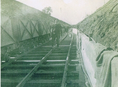
Photograph KHS Rail, Kiewa Hydroelectric Scheme Railway, Circa1940s
... This photograph shows part of the railway constructed and used for the removal of soil and rocks from the tunnels bored out of the mountains for the pipeline servicing the Hydro Electricity power stations in the Kiewa Hydroelectric Scheme. ...Kiewa Valley Historical Society Mount Beauty Information Centre 31 Bogong High Plains Rd Mt Beauty high-country This photograph shows part of the railway constructed and used for the removal of soil and rocks from the tunnels bored out of the mountains for the pipeline servicing the Hydro Electricity power stations in the Kiewa Hydroelectric Scheme. ...This photograph shows part of the railway constructed and used for the removal of soil and rocks from the tunnels bored out of the mountains for the pipeline servicing the Hydro Electricity power stations in the Kiewa Hydroelectric Scheme. This photo details an era when there were 4,000 construction workers located in two main accommodation camps, Mount Beauty (the larger one) and Bogong village. These accommodation sites were constructed and maintained as a secured or gated residential area with access only available by a special pass authorised by the Kiewa Hydroelectric Scheme. All the power used by the rail system was from electric motors connected to batteries. Overhead power poles seen on either side of the embankment details that electricity from the Scheme was in use. This use was cleaner and more environmentally friendly than the coal still used by large locomotives from city to country railways. The worker shown is not however wearing protective head and hand coverings. This is also an era where there was a lack of health and safety legislation covering workers in dangerous working conditions.Scanned photo of original black and white photo on Kodak XtraLife II paper. Picture is of a section of railway track servicing the tunnels of the Hydroelectric scheme during the 1940s - 1950sOn back of photo "Kodak XtraLife II paper"railway in kiewa electric scheme, tunneling -
 Kiewa Valley Historical Society
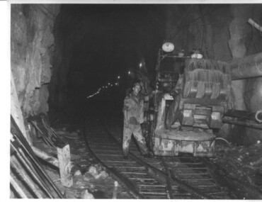
Photograph of Rail Mounted Battery operated soil Bucket, between 1941 and 1946
... July, 1950 Shows the size of the tunnel and the machinery used for excavation in the 1940's/50's. tunnel machinery water tail race Handwritten on back of photograph "Jumbo" in Tailrace Tunnel Black and white photograph Photograph of Rail Mounted Battery operated soil Bucket Photograph taken by Mr. ...This machine was in use in the 1940's during the construction of the tunnels for the Hydro Electric scheme. This particular photograph was taken in the Tailrace Tunnel which brings water from West Kiewa Power Station to the open tailrace in Mt. Beauty and then into the regulating pondage before discharge into the Kiewa River. This machine (or one similar) is on display on the Northern side of the entrance to the Visitor's Centre. The tailrace tunnel (or West Kiewa tunnel) was commenced in 1947 from both ends and the breakthrough occurred on 22nd. July, 1950Shows the size of the tunnel and the machinery used for excavation in the 1940's/50's.Black and white photographHandwritten on back of photograph "Jumbo" in Tailrace Tunneltunnel, machinery, water, tail race -
 Port of Echuca
Coloured Photograph, 04/03/1984
... used to bring the P.S Adelaide from the gardens back into the river. The P.S Adelaide is in the background. The paddle steamer appears to be up on a trailer of some sort and is surrounded but plastic orange temporary fencing. There are small mounds of soil...used to bring the P.S Adelaide from the gardens back into the river. The P.S Adelaide is in the background. The paddle steamer appears to be up on a trailer of some sort and is surrounded but plastic orange temporary fencing. There are small mounds of soil ...The P.S Adelaide was launched on 21st July 1866. It was owned by J.G.Grassie from Poon Boon Station and the Officer Family of Murray Downs Station Swan Hill. The Adelaide was named after the niece of the Officer Bros, Adelaide Blackwood. The shipwright who built her was George Linklater. The Adelaide brought wool and passengers from the wool stations on the Murray and Darling Rivers down to the Echuca Wharf. In 1872 she was sold to David Blair & Sons. She was used to bring timber from the Barmah Forest to the Echuca Wharf. She did this work for the next 80 years. In 1953 she was tied up near the Mill and left. In 1958 she went to Paringa South Australia to work in the sawmill industry again. In 1960 the Echuca Apex Club and The Echuca Historical Society raised enough funds to buy the P.S. Adelaide and return her to Echuca. In November 1963 she was lifted out of the water and placed in Hopwood Gardens as this was thought to be a way of preserving her. In 1984 it was decided to return her to the water to resume work as a passenger vessel. In that time the Port of Echuca and the Echuca Wharf had been restored as a Tourist Precinct. This photograph shows the beginning of the task to return her to the river. It took several weeks in March 1984.The P.S Adelaide is extremely significant as it it the oldest known wooden hulled paddle steamers in the world. She was built in Echuca in 1866 and still operates on the Murray River today. She has worked in the Wool Industry, the Timber Industry and the Tourist Industry.This is a coloured square photograph of an orange front end loader clearing a track from Hopwood Gardens down to the river. The track was used to bring the P.S Adelaide from the gardens back into the river. The P.S Adelaide is in the background. The paddle steamer appears to be up on a trailer of some sort and is surrounded but plastic orange temporary fencing. There are small mounds of soil in the foreground.On the orange front end loader are the numbers "5900" and the word "case." p.s. adelaide, grassie, j.g, port of echuca, linklater, george, poon boon station, blair, david, murray river, darling river, logging industry, officer brothers., barmah forest, fulton & shaw, hutchinson, kevin, murray downs station, blackwood, adelaide -
 Kiewa Valley Historical Society
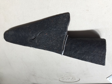
Drill Bit Diamond, circa mid to late 1900's
... The use of "coring" to obtained samples for the SEC Kiewa Hydro Electricity Scheme(1920's onward) was to analyse the core to obtain temperature and rainfall patterns shown by the levels of layered solidified soil(rock). ...The use of "coring" to obtained samples for the SEC Kiewa Hydro Electricity Scheme(1920's onward) was to analyse the core to obtain temperature and rainfall patterns shown by the levels of layered solidified soil(rock). ...This hollow core bit has hard cutting inserts for drilling into rock. It was used to drill and recover 50mm diameter (most common size) rock cores. The rock cores were assessed by geologists and engineers to provide information for design of structures such as tunnels, dams and underground power stations (eg. McKay Creek Power Station, West Kiewa Power Station). This type of bit was also used where damage to the surrounding rock had to be minimised. The Diamond Drill Bit,used in the early 1900's, when it was primarily used as a method of sampling rock for ore deposits and oil exploration resulting in a "coring" of rock. The use of "coring" to obtained samples for the SEC Kiewa Hydro Electricity Scheme(1920's onward) was to analyse the core to obtain temperature and rainfall patterns shown by the levels of layered solidified soil(rock). This diamond drill would have been used in the early 1900's to provide a sub strata map of temperature and water patterns (over an long period of time). This was a pre requisite to any decisions about the viability of the region to provide the water needed for a successful hydro electricity scheme.This diamond drill for core sampling was at the forefront of the analysis whether to construct a hydro electrical facility in the Kiewa Valley and the adjoining alpine region. The rock core samples produced were assessed by geologists and structural engineers. It was only after extensive core drilling covering the region that solid scientific evidence could be provided to start the "SEC Vic Hydro Electricity Scheme" within its current boundaries.This "diamond" drill bit has eight "teeth" at its cutting edge. The drill creates an 55mm hole in extremely hard rock material to obtain 50mm core samples.. Three quarters down the shank it has thread screw channels to attach the bit to the drill pipe. The coring pipe attaches via screwing it onto this bit. Core samples are the main objective of this tool.alternate energy supplies, alpine feasibility studies temperature, rainfall, sec, kiewa hydro electric scheme, electricity -
 Orbost & District Historical Society
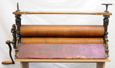
mangle, Early 20th century
... use. The washing process itself involved lifting the items from the cold soak and wringing or mangling each item before transferring them, with more soap flakes, into the copper for boiling. Items that remained soiled...use. The washing process itself involved lifting the items from the cold soak and wringing or mangling each item before transferring them, with more soap flakes, into the copper for boiling. Items that remained soiled ...A mangle or wringer is a mechanical laundry aid consisting of two rollers in a sturdy frame, connected by cogs and, in its home version, powered by a hand crank or electrically. A household mangle/wringer could be attached to a bench for easier use. The washing process itself involved lifting the items from the cold soak and wringing or mangling each item before transferring them, with more soap flakes, into the copper for boiling. Items that remained soiled, even after an overnight soak, were rubbed on a scrubbing board before being transferred to the copper. The clothes mangle would be used to squeeze out all the excess water. Clothes would then be hung out to dry on a clothes line, or laid over a clothes-horse next to the kitchen or living room fire. This one was owned by the mother of Bob Clarke, an Orbost resident.This item is an example of the typical laundry equipment used by families in the Orbost district in the early 20th century.Clothes mangle [wringer] which has a wooden and metal turning handle. It has a ratchet and 2 tap screws for pressure. It has of two rollers in a frame, connected by cogs and is powered by a hand crank.On top - "No. Hardwood Rolls 124" Front - "Household Clothes Mangle Steel ball bearings The American Wringer Company New York USA"laundry wringer mangle