Showing 952 items matching "surveyor"
-
 Port Melbourne Historical & Preservation Society
Book - Town of Port Melbourne, Arthur Victor Heath, Town Surveyor et al, Surveyors Report Book, 1901
... Reports to Council hand entered by Town Surveyor and ATS, with marginal notes on actions taken by Council....Book of reports of Port Melbourne Town Surveyor 1901-1911: 475 pp volume bound in dark green with maroon spine and corners. ...Stamped inside cover and on some pages, 'Town of Port Melbourne Surveyors Office'...Arthur Victor Heath, Town Surveyor...Gold stamped on spine 'Minute Book' but added leather label below reads 'Surveyors Report Book'. Some inserts (glued in) Surveyors Report Book Book Town of Port Melbourne Arthur Victor Heath, Town Surveyor H V Champion, Acting Town Surveyor ...Reports to Council hand entered by Town Surveyor and ATS, with marginal notes on actions taken by Council.Book of reports of Port Melbourne Town Surveyor 1901-1911: 475 pp volume bound in dark green with maroon spine and corners. Gold stamped on spine 'Minute Book' but added leather label below reads 'Surveyors Report Book'. Some inserts (glued in)Stamped inside cover and on some pages, 'Town of Port Melbourne Surveyors Office'sandridge lagoon, local government - town of port melbourne, fishermans bend, flood, fire and fire services, port melbourne town hall, transport - horse, transport - tramways, parks and gardens, engineering - roads streets lanes and footpaths, excelsior hall, societies clubs unions and other organisations, built environment, industry - manufacturing, engineering - canals and drainage, crimes and misdemeanours, transport - ferries, south melbourne, arthur victor heath, george beazley, h v champion, business and traders - hotels -
 Surrey Hills Historical Society Collection
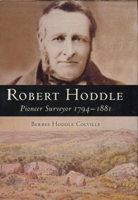
Book, Robert Hoddle: pioneer surveyor 1794-1881, 2004
... Robert Hoddle: pioneer surveyor 1794-1881...Robert Hoddle was the first Surveyor General of Victoria. He arrived in Australia in 1823 and was one of the very earliest surveyors to explore, measure and map large areas of this vast, varied and difficult countryside, in a burgeoning era of pastoral settlement. 1837 saw him appointed Surveyor in Charge of the Port Phillip District. ...Robert Hoddle was the first Surveyor General of Victoria. He arrived in Australia in 1823 and was one of the very earliest surveyors to explore, measure and map large areas of this vast, varied and difficult countryside, in a burgeoning era of pastoral settlement. 1837 saw him appointed Surveyor in Charge of the Port Phillip District. ...Robert Hoddle was the first Surveyor General of Victoria. He arrived in Australia in 1823 and was one of the very earliest surveyors to explore, measure and map large areas of this vast, varied and difficult countryside, in a burgeoning era of pastoral settlement. 1837 saw him appointed Surveyor in Charge of the Port Phillip District. ...(Ms) Berres Hoddle Colville is a local Surrey Hills resident and is a descendant of Robert Hoddle. Robert Hoddle was the first Surveyor General of Victoria. He arrived in Australia in 1823 and was one of the very earliest surveyors to explore, measure and map large areas of this vast, varied and difficult countryside, in a burgeoning era of pastoral settlement. 1837 saw him appointed Surveyor in Charge of the Port Phillip District. This book is based firmly on substantial extracts from Hoddle's own diary and other writings. Includes black and white sketches, maps and colour pages.Robert Hoddle was the first Surveyor General of Victoria. He arrived in Australia in 1823 and was one of the very earliest surveyors to explore, measure and map large areas of this vast, varied and difficult countryside, in a burgeoning era of pastoral settlement. 1837 saw him appointed Surveyor in Charge of the Port Phillip District. This book is based firmly on substantial extracts from Hoddle's own diary and other writings. Includes black and white sketches, maps and colour pages.Front endpaper: SURREY HILLS HISTORICAL / SOCIETY / PURCHASED FROM / THE AUTHOR ON THE OCCASION / OF HER TALK ON ROBERT HODDLE / TO THIS SOCIETY ON 17-10-[20]05 Title page: signed by the author: Berres Hoddle Colville / 17 October 2005 /(mr) robert hoddle, surveyors, (ms) berres hoddle colville -
 Nillumbik Shire Council
Public Art: Ernst FRIES (b.1934 Wurzburg, Germany - arrived 1959 Aus), Ernst Fries, Surveyor of Suburban Environs, Location: Alistair Knox Park, Main Road, Eltham, 1991
... Surveyor of Suburban Environs, Location: Alistair Knox Park, Main Road, Eltham ......surveyor...'Surveyor of Suburban Environs' was one of the acquisitions from the 1991 Eltham Art Awards (now known as the Nillumbik Prize - and formally the Nillumbik Art Awards). ...Nillumbik Shire Council melbourne 'Surveyor of Suburban Environs' was one of the acquisitions from the 1991 Eltham Art Awards (now known as the Nillumbik Prize - and formally the Nillumbik Art Awards). ...'Surveyor of Suburban Environs' was one of the acquisitions from the 1991 Eltham Art Awards (now known as the Nillumbik Prize - and formally the Nillumbik Art Awards). This was the first piece acquired from this award which was suitable for a public space. Nillumbik is referred to as the "Green Wedge" and the sculpture "Surveyor of Suburban Environs" suggests a watchful observer of the surrounding landscape. The sculpture's central motif represents an eye held up on a pedestal by a tail. Its form has been likened to the Eye of Horus, an ancient Egyptian symbol of protection, royal power and good health personified in the goddess Wadjet or 'green one'. This likeness would suggest that the observer or surveyor has a divine status and spiritual connection to its environment. Polished stainless steel sculpture comprising an eye reminiscent of ancient egyptian hieroglyphics, which is held up with a tappered and jaggered tail like pedestal. Concrete base. N/Apublic art, fries, spiritual, eye, stainless steel, goddess, surveyor, sculpture, environment -
Ringwood and District Historical Society
Envelope, Packet: Hull (Surveyor) - Letter 1854
... Packet: Hull (Surveyor) - Letter 1854....4-page letter (copy) to Surveyor General from Mr Hull 1854...Ringwood and District Historical Society 125A Warrandyte Road Ringwood North melbourne 4-page letter (copy) to Surveyor General from Mr Hull 1854 Packet: Hull (Surveyor) - Letter 1854. ...4-page letter (copy) to Surveyor General from Mr Hull 1854 -
Ringwood and District Historical Society
Envelope, Packet: Paper on Clement Hodgkinson, Nunawading Surveyor
... Packet: Paper on Clement Hodgkinson, Nunawading Surveyor...Paper delivered to Nunawading Historical Society August 1967 on Clement Hodgkinson, Surveyor of Nunawading; Letter to Ellie Pullin...Ringwood and District Historical Society 125A Warrandyte Road Ringwood North melbourne Paper delivered to Nunawading Historical Society August 1967 on Clement Hodgkinson, Surveyor of Nunawading; Letter to Ellie Pullin Packet: Paper on Clement Hodgkinson, Nunawading Surveyor Envelope ...Paper delivered to Nunawading Historical Society August 1967 on Clement Hodgkinson, Surveyor of Nunawading; Letter to Ellie Pullin -
Port Melbourne Historical & Preservation Society
Book - Borough of Sandridge/Port Melbourne, Surveyor's correspondence, Charles Clay, Borough Surveyor et al, 1877
... Book of Sandridge/Port Melbourne Borough Surveyors' correspondence copies, 1877 - 1890 re various contracts, streets, abattoirs, other engineering projects etc....Charles Clay, Borough Surveyor...Book Borough of Sandridge/Port Melbourne, Surveyor's correspondence Charles Clay, Borough Surveyor Arthur Victor Heath, Borough Surveyor ...Book of Sandridge/Port Melbourne Borough Surveyors' correspondence copies, 1877 - 1890 re various contracts, streets, abattoirs, other engineering projects etc.local government - borough of sandridge, local government - borough of port melbourne, engineering - roads streets lanes and footpaths, arthur victor heath, town clerks, charles clay -
 Port of Echuca
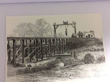
A black and white photograph of a drawing, Black and white photograph of a drawing depicting the construction of the iron Murray Bridge, at Echuca, showing Surveyor, bridge workers, hoists, a crane, and much activity, 1981
... Black and white photograph of a drawing depicting the construction of the iron Murray Bridge, at Echuca, showing Surveyor, bridge workers, hoists, a crane, and much activity....A black and white photograph of a drawing, depicting the construction of the iron Murray Bridge at Echuca, showing the Surveyor, the bridge workers, hoists , a crane, and much activity....Black and white photograph of a drawing depicting the construction of the iron Murray Bridge, at Echuca, showing Surveyor, bridge workers, hoists, a crane, and much activity. ...Original negative and photograph held by The Age, before by Orm Cook, Echuca. Photo is of a drawing of Bridge work taking place in 1877, across Murray River at Echuca. Orm Cook gave The Age the photograph in 1981 as the round arches on the bridge were about to be removed.A bridge crossing of the Murray River was needed by 1877. It linked Echuca and Moama in a more tangible way. The bridge was funded privately and public use of it was discussed for the next several years.A black and white photograph of a drawing, depicting the construction of the iron Murray Bridge at Echuca, showing the Surveyor, the bridge workers, hoists , a crane, and much activity.Written in pen on the back, "Murray Bridge at Echuca under construction. Original to 'Age' came from Orm Cook. Also the numbers 6530 written in pen. Also on the back is a rectangular stamp with these words inside the rectangle. "COPYRIGHT. This photograph may not be reproduced without permission in writing from the Editor of "The Age" 250 Spencer Street, Melbourne, and 39/41 York St, Sydney.murray river, bridge work, bridge construction, bridge workers., the age newspaper., orm cook. -
Stawell Historical Society Inc
Map, G C Birch Mining Surveyor, Magdala Cum Moonlight Co. Plan of Stawell Goldfield, c1900
... G C Birch Mining Surveyor ...G C Birch Mining Surveyor...Map G C Birch Mining Surveyor ...Shows Sloanes & Scotchmans Coy AreaShowing underground drives. c1900G C Birch Mining Surveyor mining, gold, map -
Stawell Historical Society Inc
Map, Gold Mines of Australia, Plan of Stawell Goldfield. Mining Leases, 1952
... G G Birch Mining Surveyor...G C Birch Mining Surveyor...Map Gold Mines of Australia G C Birch Mining Surveyor ...And Shaft Locations 1952 G G Birch Mining Surveyormining, gold, map -
 Victorian Aboriginal Corporation for Languages
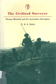
Book, D W A Baker, The civilised surveyor : Thomas Mitchell and the Australian Aborigines, 1997
... The civilised surveyor : Thomas Mitchell and the Australian Aborigines...Thomas Mitchell, surveyor in Sydney from 1827 at the time when Squatters were extending their runs with huge detriment to the Aboriginal population. ...His conviction was in the superiority of the British civilisation. The civilised surveyor : Thomas Mitchell and the Australian Aborigines Book D W A Baker ...Thomas Mitchell, surveyor in Sydney from 1827 at the time when Squatters were extending their runs with huge detriment to the Aboriginal population. Mitchell and his men were ambiguous in their treatment of the people. His conviction was in the superiority of the British civilisation.Maps, b&w illustrationsthomas mitchell, new south wales history, race relations, racism, colonisation -
Port Melbourne Historical & Preservation Society
Book - Borough of Sandridge, Charles Clay, Borough Surveyor, Surveyor's Reports, 1877
... Surveyor Charles CLAY's reports to Council March 1877 to June 1882, handwritten. 176pp volume bound in maroon linen with red spine; sticker on front: MINUTE BOOK; 'Surveyor's Reports' hand printed...Charles Clay, Borough Surveyor...Two printed Agendas 1881 and 1882 pasted in front. Surveyor Charles CLAY's reports to Council March 1877 to June 1882, handwritten. 176pp volume bound in maroon linen with red spine; sticker on front: MINUTE BOOK; 'Surveyor's Reports' hand printed Surveyor's Reports Book Borough of Sandridge Charles Clay, Borough Surveyor ...Surveyor Charles CLAY's reports to Council March 1877 to June 1882, handwritten. 176pp volume bound in maroon linen with red spine; sticker on front: MINUTE BOOK; 'Surveyor's Reports' hand printedThree names/addresses noted on first page. Two printed Agendas 1881 and 1882 pasted in front.local government - borough of sandridge, engineering - roads streets lanes and footpaths, port melbourne town hall, transport - tramways, engineering - canals and drainage, celebrations fetes and exhibitions, business and traders, fishermans bend, fire and fire services, flood, engineering - bridges, utilities, health - general health, built environment - domestic, industry - manufacturing, livestock, transport - railways, charles clay, sandridge lagoon, business and traders - hotels -
 Greensborough Historical Society
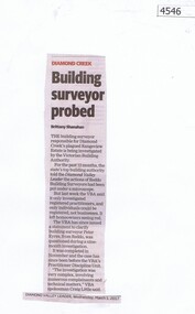
Newspaper Clipping, Diamond Valley Leader, Building surveyor probed, 01/03/2017
... Building surveyor probed...The building surveyor responsible for Diamond Creek’s plagued Rangeview Estate is being investigated by the Victorian Building Authority...Building surveyor probed Newspaper Clipping Diamond Valley Leader ...The building surveyor responsible for Diamond Creek’s plagued Rangeview Estate is being investigated by the Victorian Building AuthorityNews article 1 page, black text.diamond creek, building surveyor, investigation -
Port Melbourne Historical & Preservation Society
Book - Town of Port Melbourne Surveyor's reports, A V Heath, Arthur Victor Heath, Town Surveyor, 1911- 1917
... Heath's book of Town of Port Melbourne Surveyor's Reports 1911 to 1917...Arthur Victor Heath, Town Surveyor...Heath's book of Town of Port Melbourne Surveyor's Reports 1911 to 1917 Book Town of Port Melbourne Surveyor's reports, A V Heath Arthur Victor Heath, Town Surveyor ...A.V. Heath's book of Town of Port Melbourne Surveyor's Reports 1911 to 1917local government - town of port melbourne, arthur victor heath -
Port Melbourne Historical & Preservation Society
Plan - Photographic copy, Plan of allotments marked at Sandridge, 1849, Lindsay Clarke, Surveyor, c. 1849
... Photographic copy of 'Plan of allotments marked at Sandridge in the Parish of South Melbourne; by surveyor Lindsay Clarke 1849...Lindsay Clarke, Surveyor...Port Melbourne Historical & Preservation Society Port Melbourne Town Hall 333 Bay Street Port Melbourne melbourne Town Planning Business and Traders - Hotels Lindsay CLARKE Wilbraham Frederick Evelyn LIARDET WFE LIARDET On back, '7' in ink Photographic copy of 'Plan of allotments marked at Sandridge in the Parish of South Melbourne; by surveyor Lindsay Clarke 1849 Plan Photographic copy, Plan of allotments marked at Sandridge, 1849 Lindsay Clarke, Surveyor ...Photographic copy of 'Plan of allotments marked at Sandridge in the Parish of South Melbourne; by surveyor Lindsay Clarke 1849On back, '7' in inktown planning, business and traders - hotels, lindsay clarke, wilbraham frederick evelyn liardet, wfe liardet -
Port Melbourne Historical & Preservation Society
Plan - Proposed crossing, Rouse Street at Nott Street, George Kelly, Borough Surveyor, 27 Oct 1864
... Kelly, Cr.(?), Borough Surveyor, Sandridge, 27-10-1864...George Kelly, Borough Surveyor...Kelly, Cr.(?), Borough Surveyor, Sandridge, 27-10-1864 Place of Proposed Crossing in Rouse Street (Corner Nott Street) Plan Plan Proposed crossing, Rouse Street at Nott Street George Kelly, Borough Surveyor ...Place of Proposed Crossing in Rouse Street (Corner Nott Street) PlanGeo. Kelly, Cr.(?), Borough Surveyor, Sandridge, 27-10-1864engineering - roads streets lanes and footpaths, george kelly -
 Ringwood and District Historical Society
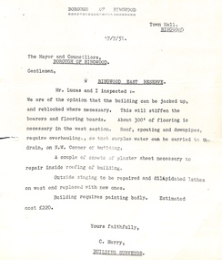
Administrative record - Borough of Ringwood 17/7/51 report to Mayor and Councillors, Document from C Merry, Building Surveyor Ringwood East Reserve
... Document from C Merry, Building Surveyor Ringwood East Reserve...Building report Ringwood East Reserve from C Merry, Building Surveyor and Mr Lucas to the Mayor and Councillors Borough of Ringwood 17/7/51. ...Document from C Merry, Building Surveyor Ringwood East Reserve Administrative record Borough of Ringwood 17/7/51 report to Mayor and Councillors ...Building report Ringwood East Reserve from C Merry, Building Surveyor and Mr Lucas to the Mayor and Councillors Borough of Ringwood 17/7/51. Building can be jacked up and reblocked where necessary. 300' of flooring is necessary in the west section. Roof, spouting and downpipes require overhauling. Needs some repair work inside and outside. Estimated cost 220 pounds. -
Port Melbourne Historical & Preservation Society
Plan - Open drainage channel, cnr Beach Street and Railway Place, Port Melbourne, Frederick William Bull, Principal Surveyor, 1862
... "Open Channel at Foot of Railway Place":Signed by Frederick William Bull, Principal Surveyor...Frederick William Bull, Principal Surveyor...Plan Open drainage channel, cnr Beach Street and Railway Place, Port Melbourne Frederick William Bull, Principal Surveyor Borough of Sandridge ...Plan for open drainage channel at corner of Beach Street and Railway Place, 1892."Open Channel at Foot of Railway Place":Signed by Frederick William Bull, Principal Surveyorengineering - canals and drainage, engineering department - borough of sandridge, frederick william bull, business and traders - hotels -
Stawell Historical Society Inc
Map, H C Bates Surveyor, Plan of Underground Workings. 1888, 25/8/1888
... Scale 80ft to an inch H C Bates Mining Surveyor 25/8/88...H C Bates Surveyor ...Stawell Historical Society Inc 46 Longfield St Stawell grampians gold mining Scale 80ft to an inch H C Bates Mining Surveyor 25/8/88 Magdala Co Now Moonlight Co Stawell Plan of Underground Workings. 1888 Map H C Bates Surveyor ...goldMagdala Co Now Moonlight Co StawellScale 80ft to an inch H C Bates Mining Surveyor 25/8/88mining -
 Bendigo Military Museum
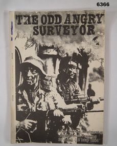
Administrative record - Army Survey Regiment Regimental Training 1984 - The Odd Angry Surveyor, Army Survey Regiment, Bendigo, 21 Feb 1984
... Army Survey Regiment Regimental Training 1984 - The Odd Angry Surveyor...This is an Administrative Instruction setting out all aspects of the Army Survey Regiment Regimental Training Exercise "Odd Angry Surveyor" during the period 30 Apr - 12 May 1984. ...Royal Australian Survey Corps RASvy Fortuna Army Survey Regiment Army Svy Regt ASR Light carboard covered A4 paper report stapled on left hand side Army Survey Regiment Regimental Training 1984 - The Odd Angry Surveyor Administrative record Army Survey Regiment Regimental Training 1984 - The Odd Angry Surveyor Army Survey Regiment, Bendigo ...This is an Administrative Instruction setting out all aspects of the Army Survey Regiment Regimental Training Exercise "Odd Angry Surveyor" during the period 30 Apr - 12 May 1984. The Exercise conducted in two phases, Phase One- being theory lessons in a number of aspects of Infantry Minor Tactics at Section Level, whilst Phase Two- was putting into practice the lessons from Phase One.Light carboard covered A4 paper report stapled on left hand sideroyal australian survey corps, rasvy, fortuna, army survey regiment, army svy regt, asr -
Stawell Historical Society Inc
Map, R.O. Robson - Authorised Surveyor, Road from Glenorchy to near Geary's Selection Callawaddy 1880, 29.04.1880
... Robson Authorised Surveyor Stawell 29.04.80...Robson - Authorised Surveyor...Robson - Authorised Surveyor ...Survey for Road CreationCloth Backed Map. Plan of Road.Parishes of Richella & Callawadda. County of Borong. Plan of Road. R.O. Robson Authorised Surveyor Stawell 29.04.80 -
Port Melbourne Historical & Preservation Society
Book - Correspondence, A V HEATH, Town Surveyor, Port Melbourne, Arthur Victor Heath, Town Surveyor, 1894 - 1898
... One of two books containing tracing paper copies of letters handwritten by Town Surveyor A.V. HEATH: from 29 January 1896 to 16 February 1898....Arthur Victor Heath, Town Surveyor...Book Correspondence, A V HEATH, Town Surveyor, Port Melbourne Arthur Victor Heath, Town Surveyor ...One of two books containing tracing paper copies of letters handwritten by Town Surveyor A.V. HEATH: from 29 January 1896 to 16 February 1898.engineering - roads streets lanes and footpaths, local government - town of port melbourne, local government - borough of port melbourne, engineering - other, arthur victor heath -
Port Melbourne Historical & Preservation Society
Plan - Weighbridge house, Sandridge, Charles Clay, Borough Surveyor, c. 1893
... near bottom right hand corner (Borough Surveyors Office)...Charles Clay, Borough Surveyor...near bottom right hand corner (Borough Surveyors Office) Plan of design for a house to the weighbridge for Borough of Sandridge, date unknown Plan Weighbridge house, Sandridge Charles Clay, Borough Surveyor ...Plan of design for a house to the weighbridge for Borough of Sandridge, date unknownSigned by Chas. Clay and Irwin Walter Brinton (?) near bottom right hand corner (Borough Surveyors Office)built environment - civic, charles clay, irwin walter brinton -
Port Melbourne Historical & Preservation Society
Book - Correspondence, A V HEATH, Town Surveyor, Port Melbourne, Arthur Victor Heath, Town Surveyor, 1890 - 1894
... One of two books containing tracing paper copies of letters handwritten by Town Surveyor A.V. HEATH: from approximately 1 Nov 1890 to 3 March 1894 (date of commencement is approximate because pages are missing). ...Arthur Victor Heath, Town Surveyor...Book Correspondence, A V HEATH, Town Surveyor, Port Melbourne Arthur Victor Heath, Town Surveyor ...One of two books containing tracing paper copies of letters handwritten by Town Surveyor A.V. HEATH: from approximately 1 Nov 1890 to 3 March 1894 (date of commencement is approximate because pages are missing). Also contains certificates of survey.engineering - roads streets lanes and footpaths, local government - town of port melbourne, local government - borough of port melbourne, engineering - other, arthur victor heath -
 Eltham District Historical Society Inc
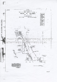
Document - Survey Plan, Country Roads Board et al, SP 12272A, Eltham-Yarra Glen Road; Brougham St to Dalton St, 1970-1976
... Roberts, Licensed Surveyor as noted 4 June 1970 Amendments in black by John L. ...Roberts, Licensed Surveyor...Roberts, Licensed Surveyor ...1970 C.R.B. Plan of Survey of Part of Crown Portion 12 Section 4 Parish of Nillumbik, County of Evelyn Eltham-Yarra Glen Road, Shire of Eltham Shows Surveyor field notes, property ownership and building type and construction. John L. Roberts, Licensed Surveyor as noted 4 June 1970 Amendments in black by John L. Roberts, L.S. 20-12-76 See also EDHS_05783 (1958)eltham-yarra glen road, 1970, 1976, a.f. munday, brougham street, dalton street, eltham, eltham clinic, g.t. & e.a. donnelly, jarrold cottage, l.m. jarrold, m.s.m. skipper, main road eltham, map, maria street, matcham skipper, mobil service centre (eltham), mobil service station, napoleon street, survey plan, white cloud cottage, country roads board -
 Greensborough Historical Society
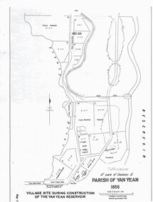
Map - Map (Copy), C. Hodgkinson, District Surveyor et al, Parish of Yan Yean 1856: Village site during construction of the Yan Yean Reservoir, 1978
... Hodgkinson, District Surveyor, redrawn by A. R. Blair 1978. ...Hodgkinson, District Surveyor...Hodgkinson, District Surveyor A R Blair ...Copy of map part Sec. 13, Parish of Yan Yean 1856, Map 3, Village site... Scale: 8 chains to 1 inch. Drawn by C. Hodgkinson, District Surveyor, redrawn by A. R. Blair 1978. 1 p. photocopy of map. yan yean reservoir, yan yean -
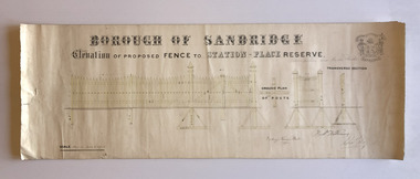 Port Melbourne Historical & Preservation Society
Plan, Charles Clay, Borough Surveyor, Elevation of Proposed Fence to Station Place Reserve, c. 1881
... Charles CLAY was the Borough Surveyor from 1860 to 1884. Fred WILLIAMS was a Councillor 1875 to 1886 and served as Mayor, 1880-81. ...Charles Clay, Borough Surveyor...Elevation of Proposed Fence to Station Place Reserve Plan Charles Clay, Borough Surveyor ...Although undated, the plan is probably from 1880-81. The plan is signed by Charles CLAY, Fred WILLIAMS and Witney Henry BATES. Charles CLAY was the Borough Surveyor from 1860 to 1884. Fred WILLIAMS was a Councillor 1875 to 1886 and served as Mayor, 1880-81. It is not known who Witney Henry BATES was. A note in pencil, probably added later, indicates the fence was between Graham and Bridge Streets.Undated Borough of Sandridge hand-drawn plan for a proposed picket fence at Station Place Reserve.'between Graham and Bridge Streets' handwritten in pencil below and to the right of the main title.local government - borough of sandridge, engineering - fences, charles clay, witney henry bates, frederick williams -
 Melbourne Tram Museum
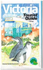
Map, Surveyor General for the Victorian Tourism Commission, "Victoria Australia Tourist Guide", 1985
... Prepared by the Surveyor General for the Victorian Tourism Commission, printed by the Government Printer, 4th edition 1985....Surveyor General for the Victorian Tourism Commission..."Victoria Australia Tourist Guide" Map Surveyor General for the Victorian Tourism Commission ...Folded map of Victoria, showing in colour relief Victorian area, national parks, highways, towns, railways, airport, wine growing areas, towns with information centres, historic parks, ski fields. NSW and SA show major towns and highways. Front cover includes an image of a Z class tram and two penguins. Has town index. Folded 7 folds horizontally by 3 folds deep. On rear is a listing of locations with major tourist destinations provided. Provides location of VicTour offices. Prepared by the Surveyor General for the Victorian Tourism Commission, printed by the Government Printer, 4th edition 1985.trams, tramways, victoria, map, victour, tourism -
 Eltham District Historical Society Inc
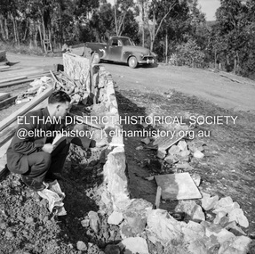
Negative - Photograph, J.A. McDonald, Building site inspection by Eltham Shire Council Building Surveyor, George Newton, c. July 1962
... Building site inspection by Eltham Shire Council Building Surveyor, George Newton...Building site inspection by Eltham Shire Council Building Surveyor, George Newton Negative Photograph J.A. ...Record of various Shire of Eltham infrastructure works undertaken during the period of 1952-1962 involving bridge and road reconstruction projects, sometimes with Eltham Shire Council Project Reference numbers quoted. It was during this period that a number of significant improvements were made to roads and new bridges constructed within the shire that remain in place as of present day (2022). In many situations, the photos provide a tangible visible record of infrastructure that existed throughout the early days of the Shire. The album was put together by or under the direction of the Shire Engineer, J.A. McDonald.1962-07, building site, building surveyor, george e. newton, houses, eltham shire council -
 Eltham District Historical Society Inc
Negative - Photograph, J.A. McDonald, Building site inspection by Eltham Shire Council Building Surveyor, George Newton, c. July 1962
... Building site inspection by Eltham Shire Council Building Surveyor, George Newton...Building site inspection by Eltham Shire Council Building Surveyor, George Newton Negative Photograph J.A. ...Record of various Shire of Eltham infrastructure works undertaken during the period of 1952-1962 involving bridge and road reconstruction projects, sometimes with Eltham Shire Council Project Reference numbers quoted. It was during this period that a number of significant improvements were made to roads and new bridges constructed within the shire that remain in place as of present day (2022). In many situations, the photos provide a tangible visible record of infrastructure that existed throughout the early days of the Shire. The album was put together by or under the direction of the Shire Engineer, J.A. McDonald.1962-07, building site, building surveyor, george e. newton, houses, eltham shire council