Showing 35 items matching "surveyors chain"
-
 Glenelg Shire Council Cultural Collection
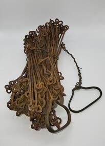
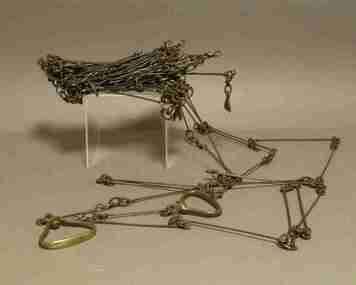
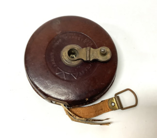
Equipment - Surveyors chain, unknown
... Surveyors chain...Before metric measurement was introduced land was measured by a tool of chains and links called a surveyor's chain. The first surveyor's chain was designed by the English clergyman and mathematician Edmund Gunter (1581-1626) and introduced in 1620. ...Surveyor chain Gunter type, 100 links measuring 66 feet in length. ...Surveying Tool Surveyor chain Gunter type, 100 links measuring 66 feet in length. ...Before metric measurement was introduced land was measured by a tool of chains and links called a surveyor's chain. The first surveyor's chain was designed by the English clergyman and mathematician Edmund Gunter (1581-1626) and introduced in 1620. It comprised of a metal chain made up of 100 links measuring a precise overall length of 66 ft or 22 yards, with each link measuring 7.92 inches (201.168 mm). The Gunter's chain was originally intended to be used in the accurate laying out and measurement of plots of land, for legal and commercial purposes, but was subsequently widely used by surveyors throughout the British Empire and Europe, with an Imperial mile being 80 times the Gunter's chain length. A tool used to survey the land before the introduction of the metric system.Surveyor chain Gunter type, 100 links measuring 66 feet in length. Hand grips at each end of chain. Wire links are approximately eight inches long. Incised tags or markers are attached to each tenth link of chain to assist with the more accurate recording of intermediate distances.surveying tool -
 Mont De Lancey
Surveyors Chain, Circa 1890
... Surveyors Chain...Surveyors chain with 100 metal links....Mont De Lancey 71 Wellington Road Wandin North yarra-valley-and-dandenong-ranges Surveying equipment Surveyors chain with 100 metal links. Surveyors Chain ...Surveyors chain with 100 metal links.surveying equipment -
 Kiewa Valley Historical Society
Surveyors Chain - Steel Band
... Surveyors Chain - Steel Band......surveyors chain...The chain and link became standard surveyors' units of length and crossed to the colonies from the United Kingdom. ...Surveyors' steel band measuring tape, known as a 'standard band', or a 'steel band chain'.This chain consists of a long narrow strip of steel of uniform width of 3 mm and thickness of 0.3 to 0.6 mm. ...The chain itself is between 20 m and 30 m long. Surveyors Chain - Steel Band ...A chain is a unit of length equal to 66 feet or 22 yards. This is a statute measure in the United Kingdom. One link is 100th part of a chain, which is 7.92 inches (20.1 cm). The chain and link became standard surveyors' units of length and crossed to the colonies from the United Kingdom. The chain is the unit of linear measurement for the survey of the public lands as prescribed by law. In Australia most building lots in the past were a quarter of an acre, measuring one chain by two and a half chains. Also street frontages, roads, laneways. The chain also survives as the length of a cricket pitch, being the distance between the stumps. Surveyors and residents of the Kiewa Valley used the Steel Band Surveyors Chain to measure distances when developing the land.Surveyors' steel band measuring tape, known as a 'standard band', or a 'steel band chain'.This chain consists of a long narrow strip of steel of uniform width of 3 mm and thickness of 0.3 to 0.6 mm. The chain itself is between 20 m and 30 m long.surveyors, surveyors chain, measurement of distance -
 Kiewa Valley Historical Society
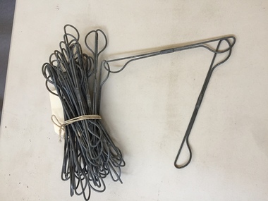
Surveyors Chain
... Surveyors Chain...See KVHS 1651 Surveyors Chain ...See KVHS 1651A bundle of galvanised wire chains linked at each end to form a chain. Each link is 9 inches long. See KVHS 1651 -
 Federation University Historical Collection
Instrument - Survey Chain, Chesterman, Gunter's Survey Chain
... chain...surveyor s chain...In pre-metric units, there were 80 chains to 1 mile (equals 1.609km) This surveyor’s chain has an 8-inch link pitch, with markers at 10 link intervals. ...A Surveyor’s Chain was 66 feet long, and made up of 100 links connected by two rings. ...In pre-metric units, there were 80 chains to 1 mile (equals 1.609km) This surveyor’s chain has an 8-inch link pitch, with markers at 10 link intervals. gunter's chain survey chain surveyor s chain perch rood surveying This metal surveyor’s chain (or Gunter's Chain) has an 8-inch link pitch, with markers at 10 link intervals, and handles at either end. ...Before metric measurement was introduced land was measured in chains and links. The chain was a precision part of a surveyor's equipment. It required frequent calibration, yet needed to be sturdy enough to be dragged through rough terrain for years. A standard survey chain is 66 feet (or 20.117m) long and made up of 100 links. Each link is 7.92 inches (approximately 201mm) long, measured from the inside of the loop. The handles are for tensioning the chain in use, they are not part of the length of the chain. In pre-metric units, there were 80 chains to 1 mile (equals 1.609km) This surveyor’s chain has an 8-inch link pitch, with markers at 10 link intervals. This metal surveyor’s chain (or Gunter's Chain) has an 8-inch link pitch, with markers at 10 link intervals, and handles at either end. A Surveyor’s Chain was 66 feet long, and made up of 100 links connected by two rings. A link in measurement includes the two rings at each end. gunter's chain, survey chain, surveyor s chain, perch, rood, surveying -
 Federation University Historical Collection
Booklet, Instruments and Adjustments, 1865
... ...surveyors chain...Barker Library (top floor) Mount Helen goldfields mining ore dressing william baragwanath alfred mica smith instruments theodolite chain surveyors chain kernot a. lilley W. Baragwanath Walhalla 1895 Black covered exercise books with hand written by William Baragwanath. ...Black covered exercise books with hand written by William Baragwanath. The handwritten notes are a copy of manuscript notes by A. Lilley Esquire and lent to Wiliam Baragwanath by J. Walker Esquire Ballarat and copied out in Septemeber 1895. Headings include: Instruments Chromatic Aberration Spherical Aberration Chromatic Spherical Aberration Notes by Professor Kernot on the Adjustment of the theodolite Sydney notes on Adjustment of Transit Theodolite Collimatino in Altitude Levelling To adjust a box sextant The Chain (Steel tape Projections of the Sphere W. Baragwanath Walhalla 1895mining, ore dressing, william baragwanath, alfred mica smith, instruments, theodolite, chain, surveyors chain, kernot, a. lilley -
Whitehorse Historical Society Inc.
Map, Survey for road from Doncaster to Ringwood, 01/03/1867
... Measurement in chains. Surveyor: Thomas E. Rawlinson....Measurement in chains. Surveyor: Thomas E. Rawlinson....Measurement in chains. Surveyor: Thomas E. Rawlinson. Survey for road from Doncaster to Ringwood Map Map ...Survey in County of Bourke, Road Plan no. 390, showing early routes of Doncaster, Whitehorse and Mitcham Roads.Survey in County of Bourke, Road Plan no. 390, showing early routes of Doncaster, Whitehorse and Mitcham Roads. Measurement in chains. Surveyor: Thomas E. Rawlinson.Survey in County of Bourke, Road Plan no. 390, showing early routes of Doncaster, Whitehorse and Mitcham Roads. parish of nunawading, parish of bulleen, whitehorse road mitcham, doncaster road, doncaster east, mitcham road mitcham -
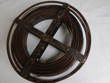
![Survey metal tape on reel with leather bag. 10 yards in length, the metal chain is subdivided every 10 links [2.2 yards].](/media/collectors/4f729f7e97f83e03086018d1/items/5f87f8fd13cca91a6c1db65a/item-media/615a8287eb51660bb8dc9e31/item-fit-380x285.jpg?cb=6) Queenscliffe Maritime Museum
Queenscliffe Maritime MuseumInstrument - Survey tape on metal reel in leather bag with other articles
... A surveyors chain is actually a thin steel band on a reel and is used for accurate measurements. ...Queenscliffe Maritime Museum 2 Wharf St Queenscliff geelong-and-the-bellarine-peninsula A surveyors chain is actually a thin steel band on a reel and is used for accurate measurements. ...A surveyors chain is actually a thin steel band on a reel and is used for accurate measurements. This 110 yard [101m] chain is subdivided every 10 links [2.2 yards or 2m]Items belonged to J P Larkin Government marine surveyor who worked on surveys up to 1938. He worked in Port Phillip and Queenscliff related surveys [e.g. Western channel, Queenscliff channel].Survey tape on metal reel in leather bag with other articles: plumb bobs, number pegs, drawing instruments in box and steel punchesMade by A.E. Parsons surveying instruments, 215 Queen Street Melbournesurveying equipment, j p larkin -
Tatura Irrigation & Wartime Camps Museum
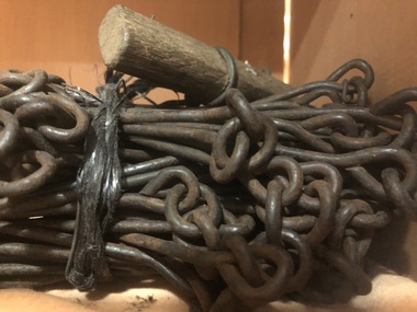
Gunter's Chain
... This is a surveyor's chain or Gunter's chain, an instrument used for measuring length. ...Tatura Irrigation & Wartime Camps Museum 49 Hogan Street Tatura the-murray This is a surveyor's chain or Gunter's chain, an instrument used for measuring length. ...This is a surveyor's chain or Gunter's chain, an instrument used for measuring length. It comprises 100 pieces of straight metal wire, looped together end to end, and fitted with swivel handles. Its overall length is one chain (22 yards or 66 feet). The Gunter's chain was named after its inventor, Edmund Gunter (1581-1626), an English clergyman, mathematician, and astronomer. survey -
Stawell Historical Society Inc
Map, Township of Stawell
... B/W map of Stawell Surveyed by Easton Johnston Contract surveyor Scale in Chains. Showing Special Allotments Reefs, Pleasant Creek Parish of Stawell. ...Stawell Historical Society Inc 46 Longfield St Stawell grampians B/W map of Stawell Surveyed by Easton Johnston Contract surveyor Scale in Chains. Showing Special Allotments Reefs, Pleasant Creek Parish of Stawell. ...B/W map of Stawell Surveyed by Easton Johnston Contract surveyor Scale in Chains. Showing Special Allotments Reefs, Pleasant Creek Parish of Stawell. Map No L4000 -
Clunes Museum
Map, DEPARTMENT OF MINES, Untitled, c1859
... .1 360 Scale 1:2500 .2 303/59 33 hand written in ink "received 15 October 1859" signed by R Broughton, James Stevenson - District Mining Surveyor .3 40 chains to an Inch...Clunes Museum 36 Fraser Street enter building through Collins Place Clunes goldfields All maps show names and locations of mines operating in the district (see reference section link to article) gold mining dept of mines .1 360 Scale 1:2500 .2 303/59 33 hand written in ink "received 15 October 1859" signed by R Broughton, James Stevenson - District Mining Surveyor .3 40 chains to an Inch .1 Map of Creswick Clunes - lists 45 mines in the Clunes enlargement and 100 mines in the Creswick enlargement .2 Department of Mines map of Clunes Creswick and shows the McDonald & Co. ...All maps show names and locations of mines operating in the district (see reference section link to article).1 Map of Creswick Clunes - lists 45 mines in the Clunes enlargement and 100 mines in the Creswick enlargement .2 Department of Mines map of Clunes Creswick and shows the McDonald & Co. Pre-emptive area. Indexes for quartz and alluvial mine locations .3 Topographical map Ref GF23 Clunes Mt. Greenock Talbot.1 360 Scale 1:2500 .2 303/59 33 hand written in ink "received 15 October 1859" signed by R Broughton, James Stevenson - District Mining Surveyor .3 40 chains to an Inchgold mining, dept of mines -
 Bendigo Military Museum
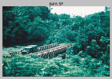
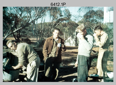
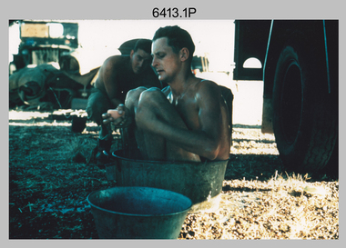
Photograph - Royal Australian Survey Corps Surveyors in the Field – Project Cutlass, New Guinea, 1956 – 1957
... In this survey operation surveyors used theodolites to observe horizontal and vertical angles and chains to measure base line distances between survey stations. ...In this survey operation surveyors used theodolites to observe horizontal and vertical angles and chains to measure base line distances between survey stations. ...This is a set of 23 photographs of surveyors and support staff in the field undertaking tasks in New Guinea 1956 – 1957. The surveyors were employed in the establishment of mapping and geodetic control for Project Cutlass, the “Ship-Shore” survey of the New Ireland province. In this survey operation surveyors used theodolites to observe horizontal and vertical angles and chains to measure base line distances between survey stations. Bob Skitch shown in photo .7P was in the 2nd year of his career in the Australian Army. He achieved the rank of Lieutenant-Colonel, and his last appointment was the CO of the Army Survey Regiment from 1976 to 1980.This is a set of 23 photographs of surveyors and support staff in the field undertaking duties during Project Cutlass located in New Ireland, New Guinea 1956 – 1957. The photographs were printed on photographic paper and are part of the Army Survey Regiment’s Collection. The photographs were scanned at 300 dpi. .1) - Photo, colour, 1956. Surveyors travelling main road from Kavieng to Namatanai, New Ireland. .2) - Photo, colour, 1956. Unidentified surveyors assessing recovery of their vehicle after bridge collapsed on west side of New Ireland. .3) - Photo, colour, 1956. Unidentified surveyors assessing recovery of their vehicle after bridge collapsed over flooded creek on west side of New Ireland. .4) - Photo, colour, 1956. Survey personnel L to R: Bev Uwins, John Lambie, Bob Thompson, New Ireland. .5) - Photo, colour, 1956. Survey base camp, New Ireland. .6) - Photo, black & white, 1956-1957. Geoff Helsham with possible human remains, New Ireland. .7) - Photo, black & white, 1956-1957. Bob Skitch undertaking survey observations using Wild T2 theodolite, New Ireland. .8) - Photo, black & white, 1956-1957. Chas Beach undertaking survey observations using Wild T2 theodolite, New Ireland. .9) & .10) - Photo, black & white, 1956-1957. Kev Parker (cook) New Ireland. .11) - Photo, colour, 1957. Brian Berkery taking a break, Top Manor Island, Lihir Island Group off New Ireland. Latitude -2° 46”, Longitude 152° 40”. .12) - Photo, colour, 1957. Survey base camp L to R: Chas Beach, Bev Uwins, Feni Islands, New Ireland. Latitude -4° 05”, Longitude 153° 45”. .13) - Photo, colour, 1957. A Hous Kiap. (Kiaps, known formally as district officers and patrol officers, were travelling representatives of the British and Australian governments), New Ireland. .14) & .15) - Photo, colour, 1957. L to R: Joe Farrington, Tom Royle Bob undertaking survey observations using theodolites from an improvised timber tower, New Ireland. .16) & .17) - Photo, colour, 1957. US Army ship FS216 used for ship-to-shore triangulation docked at Rabaul, New Britain. .18) - Photo, colour, 1957. US Army ship FS216 used for ship-to-shore triangulation docked at Kavieng, New Ireland. Sight target on top of mast. .19) - Photo, colour, 1957. Survey personnel onboard US Army ship FS392, L to R: Peter Frodsham, Bob Thompson, Doc Reid, John Underwood, remainder unidentified, New Ireland. .20) - Photo, colour, 1957. Survey base line party heading ashore, New Ireland. .21) - Photo, colour, 1957. Survey personnel rowing US Army assault boat L to R: Kev Parker, Chas Beach, folded up survey beacons overhanging stern, New Ireland. .22) - Photo, colour, 1957. Les Bailey onboard US Army ship departing Rabaul, New Britain for Brisbane. .23) - Photo, colour, 1957. Ron Newman onboard US Army ship departing Rabaul, New Britain for Brisbane. Active volcano in background..1P to .23P annotated on back – ‘Operation Cutlass’, personnel names, the year and the location. royal australian survey corps, rasvy, army survey regiment, fortuna, a, army svy regt, asr, surveying -
 Bendigo Military Museum
Photograph - Royal Australian Survey Corps Surveyors in the Field – Victoria, 1956 - 1958
... In this era surveyors used theodolites to observe horizontal and vertical angles and chains to measure base line distances between survey stations. ...In this era surveyors used theodolites to observe horizontal and vertical angles and chains to measure base line distances between survey stations. ...This is a set of two photographs of surveyors and support staff in the field undertaking tasks in Victoria 1956 – 1958. The surveyors were employed in the establishment of mapping and geodetic control. In this era surveyors used theodolites to observe horizontal and vertical angles and chains to measure base line distances between survey stations. This is a set of 23 photographs of surveyors and support staff in the field undertaking duties in Victoria 1956 – 1958. The photographs were printed on photographic paper and are part of the Army Survey Regiment’s Collection. The photographs were scanned at 300 dpi. .1) - Photo, colour, 1956. Surveyors enjoying a tea break. L to R: Tom Gilbert (cook), Barry Broad, Tony Slattery, John Van De Graff. Taken at Boonoonar, a locality south of Mildura. .2) - Photo, colour, 1958. Surveyors taking a break from driving. L to R: Leo Bub, Bob Thompson. Taken at Puckapunyal..1P to .2P annotated on back – personnel names, the year and the location. royal australian survey corps, rasvy, army survey regiment, asr, army svy regt, fortuna, surveying -
 Bendigo Military Museum
Photograph - Royal Australian Survey Corps Surveyors in the Field – North Queensland, 1958
... In this era surveyors used theodolites to observe horizontal and vertical angles and chains to measure base line distances between survey stations. ...In this era surveyors used theodolites to observe horizontal and vertical angles and chains to measure base line distances between survey stations. ...This is a set of seven photographs of surveyors and support staff in the field undertaking duties in North Queensland in 1958. The surveyors were employed in the establishment of mapping and geodetic control. In this era surveyors used theodolites to observe horizontal and vertical angles and chains to measure base line distances between survey stations. Bob Skitch shown in photos .4P to .6P was in the 2nd year of his career in the Australian Army. He achieved the rank of Lieutenant Colonel and his last appointment was the CO of the Army Survey Regiment from 1976 to 1980. The annotation on the back of photo .5P ‘Black foreground is where Bob Skitch boiled billy and started a grass fire’.This is a set of seven photographs of surveyors and support staff in the field undertaking duties in North Queensland in 1958. The photographs were printed on photographic paper and are part of the Army Survey Regiment’s Collection. The photographs were scanned at 300 dpi. .1) - Photo, colour, 1958. Surveyor in Nth QLD enjoying a bath. L to R: Don Cocker, Bob Thompson. .2) - Photo, colour, 1958. Don Cocker surveyor in Nth QLD, enjoying a bath. .3) - Photo, colour, 1958. Surveyors Nth QLD undertaking survey observations, using MRA1 tellurometer to measure base-line distances. L to R: Len Davies, Lou Sommer, John Van De Graff. MRA1 was covered to stop overheating. .4) - Photo, colour, 1958. Surveyors south of Richmond, QLD digging holes for the erection of a Bilby observation tower. L to R: John Van De Graff, Bob Skitch, Kev Moody, Mal Hayes, Don Gray .5) - Photo, colour, 1958. Surveyors south of Richmond, QLD erecting a Bilby observation tower. L to R: Tom Royle, Bob Skitch (on ground level), Mal Hayes. .6) - Photo, colour, 1958. Surveyors south of Richmond, QLD erecting a Bilby observation tower. L to R: Tom Royle, Bob Skitch, Mal Hayes, Jim McGill (on ground level). .7) - Photo, colour, 1958. Surveyors south of Richmond, QLD undertaking survey measurements from a Bilby observation tower..1P to .7P annotated on back – personnel names, the year and the location. Annotated on back of .5P ‘Black foreground is where Bob Skitch boiled billy and started a grass fire’.royal australian survey corps, rasvy, army survey regiment, asr, army svy regt, fortuna, surveying -
 Bendigo Military Museum
Photograph - RASvy Surveyors in the field, c1950s – 1960s
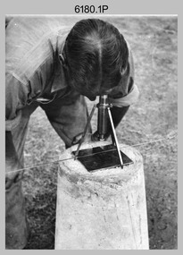
... This is a set of 1photographs of surveyors in the field measuring distances using chains, taking observations using theodolites and operating electric distance measurement equipment. ...This is a set of 17 photographs of surveyors in the field measuring distances using chains, taking observations using theodolites and operating electric distance measurement (EDM) equipment. c1950s – 1960s. ...surveyors may have been in training. The photos were most likely taken in the 1950s and 1960s. Photos .1P to .6P feature personnel setting up geodetic survey chaining equipment to measure distances. ...This is a set of 1photographs of surveyors in the field measuring distances using chains, taking observations using theodolites and operating electric distance measurement equipment. They were probably employed in establishing mapping and geodetic control operations or the surveyors may have been in training. The photos were most likely taken in the 1950s and 1960s. Photos .1P to .6P feature personnel setting up geodetic survey chaining equipment to measure distances. The surveyor in Photo .5P is LTCOL Howard Angus Johnson MBE who served from 1936 to 1954. The RA Svy surveyor in photos .7P to .12P were using a theodolite to take angular measurements. They were usually supported by an observer who recording their readings on a booking form. The surveyor in Photo .10P and .11P is LTCOL Jorge Gruszka, who served from 1955 to 1985. He was CO of the Army Survey Regiment from 1982 to 1985. The surveyor in photo .13P is cutting an identification blaze on a tree using a hammer and chisel. The tellurometer in Photos .14P to .16P was a MRA1 microwave Electronic Distance Measuring instrument (EDM) introduced in 1958. It and later models were man-portable systems that improved geodetic survey efficiencies for rapid network extension and densification replacing triangulation with EDM and theodolite traverse sometimes using Bilby Towers to extend line lengths. The surveyor with the slouch hat is Colonel James ‘Jim’ Leslie Stedman, who served from 1941 to 1978. He was Director of Military Survey from 1975 to 1978 and was appointed as Colonel Commandant (honorary appointment, Retd) of the Royal Australian Survey Corps from 1978 to 1983. Jim Stedman is demonstrating EDM equipment.This is a set of 17 photographs of surveyors in the field measuring distances using chains, taking observations using theodolites and operating electric distance measurement (EDM) equipment. c1950s – 1960s. The photographs were printed on photographic paper and are part of the Army Survey Regiment’s Collection. The photographs were scanned at 300 dpi. .1) - Photo, black & white, c1950s, unidentified personnel using geodetic survey chaining equipment. .2) to .4) - Photo, black & white, c1950s, geodetic survey chaining equipment. .5) – Photo, black & white, c1950s, Jim Stedman using geodetic survey chaining equipment to measure distances. .6) - Photo, black & white, c1950s, Unidentified personnel geodetic survey chaining equipment. .7) – Photo, black & white, mounted on card, c1950s. Unidentified surveyor undertaking observations on a coral reef using a theodolite. .8) – Photo, black & white, c1950, unidentified surveyor undertaking observations with a Tavistock theodolite. .9) – Photo, black & white, mounted on green card, c1950s. Unidentified surveyor undertaking observations using a plane table. .10) – Photo, black & white, c1955, Jorge Gruszka undertaking observations with a theodolite. 7/55 Basic Survey Course Balcombe. .11) – Photo, black & white, c1950s, Jorge Gruszka undertaking observations with a theodolite. .12) – Photo, black & white, c1946-1948, unidentified surveyor undertaking observations with a theodolite to gain control for the mapping of the Snowy Mountain Diversion Scheme. .13) – Photo, black & white, c1950s, unidentified surveyor cutting a blaze in a tree. .14) and .15) – Photo, black & white, c1960s, Jim Stedman demonstrating EDM equipment. .16) – Photo, black & white, c1960s, L to R: Jim Stedman (probably) and unidentified surveyor demonstrating EDM equipment. .17) – Photo, black & white, 1956, Operation Cutlass - Surveyors SPR W. Crane and J.A. Campbell undertaking observations with a theodolite in extreme conditions..1P on back - First Order Chaining Equipment .2P on back - First Order Chaining Equipment .3P on back - Full catenary 1800 – 1960 replaced by EDM .4P on back - First Order Chaining Equipment .5P on back - H.A. Johnson, Benambra baseline? 1st Order Chaining .6P on back - Chaining .7P on front - Difficult observing conditions especially when the tide is in. The station is sighted (sic) on a coral reef. .8P on back - Tavistock. .10P on back of duplicate in Photo Folder 14 – George (sic) Gruszka 7/55 Basic Survey Course Balcomme (sic) 1955/56 .14P and .15P on back - Jim Stedman demonstrating early EDM equipment.royal australian survey corps, rasvy, army survey regiment, army svy regt, fortuna, asr, surveying -
 Kiewa Valley Historical Society
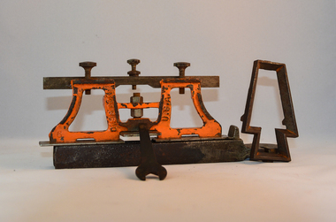
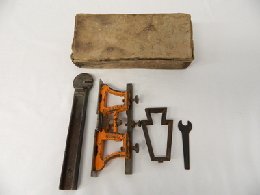
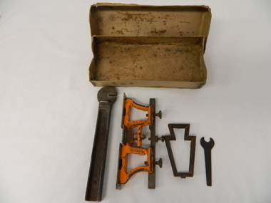
Sharpener Saw Raker/Jointer, early 1900s
... Chain saws, chain and ball(clearing) and bulldozing methods came in the mid 1900's. This particular saw sharpening method was used by surveyors laying down boundaries for the S.E.C. ...This raker/jointer/guage set is a sharpening tool for cross cut logging saws. The logging saws used in the early 1900's for the clearing of forests required constant sharpening of their "cutting teeth". The logging of forested areas during these times was very much a "hands on" method of either one or two men by the use of saw or hand axe. Chain saws, chain and ball(clearing) and bulldozing methods came in the mid 1900's.This particular saw sharpening method was used by surveyors laying down boundaries for the S.E.C. Victoria Hydro Electricity Scheme (1920's). This item was given to a local Kiewa Valley lad who accompanied the initial surveyors. The lad was responsible for the tendering and feeding of the surveyors "pack horses". Surveys during this period and in the dense mountainous terrain of the Victorian Alps was both exhausting and hazardous. Overnight accommodation at various log cabins was not always possible and swag/tent alternative was the "fall back" This raker/jointer saw sharpener was made in the USA (DISSTON) from cast and flat iron. The main body has been painted in orange. It has three adjustment screws on the top horizontal bar and one bolt on(adjusting) leveling platform on the bottom. The small size and weight of this saw sharpener was ideal for the travelling/mobile logger or surveyor(as in this case). The main frame resembles two towers connected by two horizontal bars and the top of the towers has a horizontal bar with adjustment screws. See KVHS 0090 (B) for setting stake wedge adjusting the rake and cutting angle and KVHS 0090 (C) for a small spanner (for adjustments).On one inner supports is stamped "DISSTON" and on the other "U.S.A."hand tool, saw, sharpening method, tree felling. -
 Kiewa Valley Historical Society
Tool Spring Set, circa early 1900s
... surveyors commissioned by The S.E.C. Victoria Kiewa Hydro Electricity Scheme project mapping the relevant Alpine region. Chain...surveyors commissioned by The S.E.C. Victoria Kiewa Hydro Electricity Scheme project mapping the relevant Alpine region. Chain ...This is part of a crosscut saw raker/jointer/guage set used to bend the tip of each cutter tooth for cross cut logging saws. The logging saws used in the early 1900's for the clearing of forests required constant sharpening of their "cutting teeth". The logging of forested areas during these times was very much a "hands on" method of either one or two men by the use of saw or hand axe. This item was used by the surveyors commissioned by The S.E.C. Victoria Kiewa Hydro Electricity Scheme project mapping the relevant Alpine region. Chain saws, chain and ball(clearing) and bulldozing methods came in the mid 1900's.This particular saw sharpening method was used by surveyors laying down boundaries for the S.E.C. Victoria Hydro Electricity Scheme (1920's). This item was given to a local Kiewa Valley lad who accompanied the initial surveyors. The lad was responsible for the tendering and feeding of the surveyors "pack horses". Surveys work during this period and in these dense mountainous terrain of the Victorian Alps was both exhausting and hazardous. Overnight accommodation at various log cabins was not always possible and swag/tent alternative was the "fall back".This cast iron Spring Setting tool has a main body of angle iron contours with one end tappered into a flat circular extension with a slit (3/32" wide) running from the top to nearly the centre(15mm). This slit is to allow the bending of each "cutter tooth" of the cross cut saw. The "bottom of this slit has a semi circular ending. Protruding from one side of the bar body, and close to the "slit" is a tounge like extension (wedge) to fasten the spring set tool into a tree stump. See KVHS 0090 (A) for its Raker/Jointer saw sharpening guage set partner. Also see KVHS 0090 (C) for the associated wrench. On one side of the bar "DISSTON U.S.A."hand tool, saw, sharpening method, tree felling -
 Kiewa Valley Historical Society
Spanner Small, 1920's
... Chain saws, chain and ball(clearing) and bulldozing methods came in the mid 1900's. This particular spanner was part of a crosscut saw sharpening tool and method was used by surveyors laying down boundaries for the S.E.C. ...This spanner, part of a raker/jointer/guage set which is a sharpening tool for cross cut logging saws. The logging saws used in the early 1900's for the clearing of forests required constant sharpening of their "cutting teeth". The logging of forested areas during these times was very much a "hands on" method of either one or two men by the use of saw or hand axe. Chain saws, chain and ball(clearing) and bulldozing methods came in the mid 1900's.This particular spanner was part of a crosscut saw sharpening tool and method was used by surveyors laying down boundaries for the S.E.C. Victoria Hydro Electricity Scheme (1920's). This item was given to a local Kiewa Valley lad who accompanied the initial surveyors. The lad was responsible for the tendering and feeding of the surveyors "pack horses". Surveys during this period and in the dense mountainous terrain of the Victorian Alps was both exhausting and hazardous. Overnight accommodation at various log cabins was not always possible and swag/tent alternative was the "fall back"This small spanner is part of the Raker/Jointer Gauge saw set and is made from forged steel. The nut grip is of the two tightening nuts on the main construction frame. See KVHS 0090 (A &B) for the other items making up the sharpening tools.hand tool, saw, sharpening method, tree felling. -
 Emerald Museum & Nobelius Heritage Park
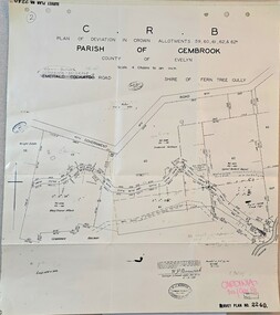
Map - Plan of deviation in Crown Allotments - parish of Gembrook, Gembrook-Belgrave Rd, Alterations to allotments 59, 60, 61,62 & 62A for the formation of Belgrave-Gembrook Rd., 1929, c1929
... CRB/Plan of deviation in Crown Allotments 59, 60, 61, 62 & 62A/Parish of Gembrook, County of Evelyn/Scale 4 chains to an inch/Gembrook-Belgrave Road/certification of plan (signed) WP BONWICK, Surveyor Licensed under Act 2679/5-2-29/Survey Plan 2240...Emerald Museum & Nobelius Heritage Park 5 Crichton Rd Emerald yarra-valley-and-the-dandenong-ranges CRB/Plan of deviation in Crown Allotments 59, 60, 61, 62 & 62A/Parish of Gembrook, County of Evelyn/Scale 4 chains to an inch/Gembrook-Belgrave Road/certification of plan (signed) WP BONWICK, Surveyor Licensed under Act 2679/5-2-29/Survey Plan 2240 Image of Plan of deviation in Crown Allotments - parish of Gembrook, Gembrook-Belgrave Rd., allotments 59, 60, 61,62 & 62A Alterations to allotments 59, 60, 61,62 & 62A for the formation of Belgrave-Gembrook Rd., 1929 Map Plan of deviation in Crown Allotments - parish of Gembrook, Gembrook-Belgrave Rd., ...Image of Plan of deviation in Crown Allotments - parish of Gembrook, Gembrook-Belgrave Rd., allotments 59, 60, 61,62 & 62ACRB/Plan of deviation in Crown Allotments 59, 60, 61, 62 & 62A/Parish of Gembrook, County of Evelyn/Scale 4 chains to an inch/Gembrook-Belgrave Road/certification of plan (signed) WP BONWICK, Surveyor Licensed under Act 2679/5-2-29/Survey Plan 2240 -
 Greensborough Historical Society
Article, Anne Paul, Robert Hoddle - Chains and Grids in Terra Nullius, January 2024
... Article about Robert Hoddle, his work as a surveyor in early Melbourne and the use of the 'chain' to measure distance....Greensborough Historical Society 34A Glenauburn Road Lower Plenty Lower Plenty melbourne Article about Robert Hoddle, his work as a surveyor in early Melbourne and the use of the 'chain' to measure distance. ...Article about Robert Hoddle, his work as a surveyor in early Melbourne and the use of the 'chain' to measure distance.14 page article text and illus.melbourne history, robert hoddle -
 Greensborough Historical Society
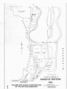
Map - Map (Copy), C. Hodgkinson, District Surveyor et al, Parish of Yan Yean 1856: Village site during construction of the Yan Yean Reservoir, 1978
... Scale: 8 chains to 1 inch. Drawn by C. Hodgkinson, District Surveyor, redrawn by A. ...Scale: 8 chains to 1 inch. Drawn by C. Hodgkinson, District Surveyor, redrawn by A. ...Copy of map part Sec. 13, Parish of Yan Yean 1856, Map 3, Village site... Scale: 8 chains to 1 inch. Drawn by C. Hodgkinson, District Surveyor, redrawn by A. R. Blair 1978. 1 p. photocopy of map. yan yean reservoir, yan yean -
 Bendigo Historical Society Inc.
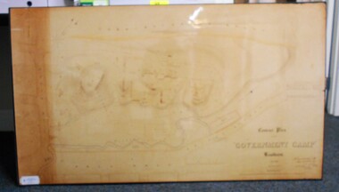
Map - CONTOUR PLAN OF THE GOVERNMENT CAMP SANDHURST 1854, 1994
... Surveyor, 11th December 1854.' Shown on map: Pall Mall, Bendigo Creek, Commissioner's Gully, View Place (now View Street), Post Office, Bank of Victoria, District Surgeon, Sandhurst Fire Brigade, Police Hospital, Flagstaff, Gold Office, License Shed, Military Barracks, Stables, Commissioner's Buildings, Police Office. Old Cemetery, Garden. Reference on righthand side: 'Stone or brick buildings are tinted in crimson. Wooden buildings tinted in Indian Ink. Tents and other temporary structures tinted in Burnt Sienna.' Scale of Chains...Surveyor, 11th December 1854.' Shown on map: Pall Mall, Bendigo Creek, Commissioner's Gully, View Place (now View Street), Post Office, Bank of Victoria, District Surgeon, Sandhurst Fire Brigade, Police Hospital, Flagstaff, Gold Office, License Shed, Military Barracks, Stables, Commissioner's Buildings, Police Office. Old Cemetery, Garden. Reference on righthand side: 'Stone or brick buildings are tinted in crimson. Wooden buildings tinted in Indian Ink. Tents and other temporary structures tinted in Burnt Sienna.' Scale of Chains ...Contour map (copy) of the Government Camp Sandhurst, 1854. Map is mounted on coreflute and laminated. Written in bottom righthand corner 'Contour Plan of the Government Camp, Sandhurst. Dec 1854. Signed by Richard Larritt, Assistant Surveyor, 11th December 1854.' Shown on map: Pall Mall, Bendigo Creek, Commissioner's Gully, View Place (now View Street), Post Office, Bank of Victoria, District Surgeon, Sandhurst Fire Brigade, Police Hospital, Flagstaff, Gold Office, License Shed, Military Barracks, Stables, Commissioner's Buildings, Police Office. Old Cemetery, Garden. Reference on righthand side: 'Stone or brick buildings are tinted in crimson. Wooden buildings tinted in Indian Ink. Tents and other temporary structures tinted in Burnt Sienna.' Scale of Chains, on bottom of map. Sticker on bottom left hand corner and back of map ' Presented by Survey and Mapping, Victoria, 7th Octber, 1994'.map, bendigo, government camp, pall mall, bendigo creek, commissioner's gully, view place (now view street), post office, bank of victoria, district surgeon, sandhurst fire brigade, police hospital, flagstaff, gold office, license shed, military barracks, stables, commissioner's buildings, police office. old cemetery, garden. , survey and mapping victoria. sandhurst, bendigo. -
Bendigo Historical Society Inc.
Map - MAP WHITE HILL TO HUNTLY
... Map of Bendigo creek and adjacent leads - White Hills to Huntly replotted from old 4 chain to 1 inch survey of 1860 by G. W. Hart - Surveyor. Base of roads and streets taken from D.L.S. 1 . 10000 base maps. ...History House 11 Mackenzie Street Bendigo goldfields BENDIGO Mining Map of Bendigo creek and adjacent leads - White Hills to Huntly replotted from old 4 chain to 1 inch survey of 1860 by G. W. Hart - Surveyor. Base of roads and streets taken from D.L.S. 1 . 10000 base maps. ...Map of Bendigo creek and adjacent leads - White Hills to Huntly replotted from old 4 chain to 1 inch survey of 1860 by G. W. Hart - Surveyor. Base of roads and streets taken from D.L.S. 1 . 10000 base maps. Legend: battery site, puddling mill site, dam bank site, cutting altering course of creek, lead boundaries.bendigo, mining -
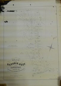 Bendigo Historical Society Inc.
Document - MARKS COLLECTION: MAP OF VICTORIA REEF MINING CLAIMS
... Surveyor. Published by John N. Macartney, Argus Agent, Sandhurst. Price 4/- each. On bottom Rh side J.W. Pearson & Co. Lith. Melbourne Plan shows mining claims and names of holders, scale (4 chains to one inch) Loddon Road, Mount Korong Road, Ironbark Gully, township of Long Gully, Quartz Miners' Arms and Gold Mines Hotel on Loddon Road....Surveyor. Published by John N. Macartney, Argus Agent, Sandhurst. Price 4/- each. On bottom Rh side J.W. Pearson & Co. Lith. Melbourne Plan shows mining claims and names of holders, scale (4 chains to one inch) Loddon Road, Mount Korong Road, Ironbark Gully, township of Long Gully, Quartz Miners' Arms and Gold Mines Hotel on Loddon Road. ...Copy of map. On bottom LH side: Plan of the Victoria Reef Sandhurst January 1867, Compiled by G.W. Hart, Mining Surveyor. Published by John N. Macartney, Argus Agent, Sandhurst. Price 4/- each. On bottom Rh side J.W. Pearson & Co. Lith. Melbourne Plan shows mining claims and names of holders, scale (4 chains to one inch) Loddon Road, Mount Korong Road, Ironbark Gully, township of Long Gully, Quartz Miners' Arms and Gold Mines Hotel on Loddon Road.bendigo, mining, victoria reef plan -
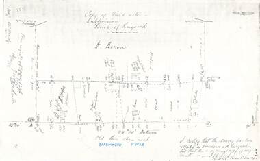 Ringwood and District Historical Society
Document - Copy of Lands Department Field Notes - Parish of Ringwood, Victoria, Field Notes 88-9/276 - Part of O.P. R72C surveyed 12.10.1888
... References include - Commencing at bank of creek, Bearing over fence read 134"12', post and rail fence, old round post, Quigley, WB house iron roof, paling & shingle roof, garden, Forshaw formerly Hoare, D Brown, stable & shed, slats & palings, orchard, Occupied by Forshaw, 4 rooms WB Cottage iron roof, Sherbin, Old three chain road, Maroondah Highway, Molloy's corner, I certify that this survey has been effected in accordance with the regulations and that this is a correct copy of my results (signed) - Reed, Assistant Surveyor, 12.10.88....References include - Commencing at bank of creek, Bearing over fence read 134"12', post and rail fence, old round post, Quigley, WB house iron roof, paling & shingle roof, garden, Forshaw formerly Hoare, D Brown, stable & shed, slats & palings, orchard, Occupied by Forshaw, 4 rooms WB Cottage iron roof, Sherbin, Old three chain road, Maroondah Highway, Molloy's corner, I certify that this survey has been effected in accordance with the regulations and that this is a correct copy of my results (signed) - Reed, Assistant Surveyor, 12.10.88. ...Foolscap size photocopy of survey map with handwritten notations. References include - Commencing at bank of creek, Bearing over fence read 134"12', post and rail fence, old round post, Quigley, WB house iron roof, paling & shingle roof, garden, Forshaw formerly Hoare, D Brown, stable & shed, slats & palings, orchard, Occupied by Forshaw, 4 rooms WB Cottage iron roof, Sherbin, Old three chain road, Maroondah Highway, Molloy's corner, I certify that this survey has been effected in accordance with the regulations and that this is a correct copy of my results (signed) - Reed, Assistant Surveyor, 12.10.88. -
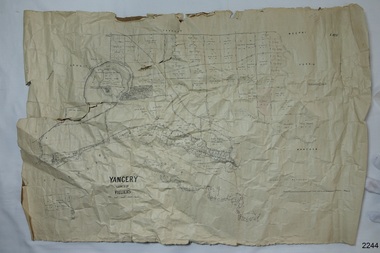 Flagstaff Hill Maritime Museum and Village
Map - Survey Map, F.F. McGovern, Yangery - County of Villiers, 1884
... surveyor William Rutledge. The map shows the growth of landholders in the district when compared to the original Rutledge survey of the 1850's. flagstaff hill warrnambool shipwrecked-coast flagstaff-hill flagstaff-hill-maritime-museum maritime-museum shipwreck-coast flagstaff-hill-maritime-village county of villiers map yangery district w.j. burson borough of warrnambool koroit purnim meerai wangoom proposal of tower hill for public recreation special survey by william rutledge William Rutledge Farnham Lincolnshire sheep Clydesdale Hand written pencil markes and figures and "Sauls fence" drawn onto map. "For Department Use only". "Scale: 8 chains ...A surveyor was employed to measure the land designated as Yangery, County of Villiers, in the Borough of Warrnambool. The area on the map is similar to the earlier Farnham Survey undertaken by William Rutledge in the 1850's. Warrnambool was a Borough between 1863-1883. Coutours, waterways, sea and other significant points are shown. The distances are accurately measured. This survey map was used for planning future land sales, recreation areas and roads. WILLIAM RUTLEDGE (1806-1876) William Rutledge surveyed the land known as Farnham in southwest Victoria in 1843. His tenants made him a profitable business from working the land there. In 1863 Rutledge moved from nearby Port Fairy to Farnham and became very successful in breeding sheep, which he imported from J.R. Kirkham of Lincolnshire, England. He also bred horses on his land. The survey map of Yangery is important for its connection with renowned surveyor William Rutledge. The map shows the growth of landholders in the district when compared to the original Rutledge survey of the 1850's.Survey map of Yangery, titled "Yangery - County of Villiers". Printed on white paper, mounted on brown paper. c. 1863-1876. Comments printed on the Map include; Special Survey by William Rutledge, Photo-lithographed at the Department of Lands and Survey, Melbourne by W.J. Burson, Price 1/- [one shilling]. Scale is in Chains. Map has boundaries of Koroit Borough, Meerai, Purnim, Wangoom, Borough of Warrnambool, Mentions the Proposal of Tower HIll for Public Recreation. The map names the owners of the land at that time. Hand written pencil marks and figures and "Sauls fence" drawn on map. Hand written pencil markes and figures and "Sauls fence" drawn onto map. "For Department Use only". "Scale: 8 chains to 1 inch" flagstaff hill, warrnambool, shipwrecked-coast, flagstaff-hill, flagstaff-hill-maritime-museum, maritime-museum, shipwreck-coast, flagstaff-hill-maritime-village, county of villiers map, yangery district, w.j. burson, borough of warrnambool, koroit, purnim, meerai, wangoom, proposal of tower hill for public recreation, special survey by william rutledge, william rutledge, farnham, lincolnshire sheep, clydesdale -
Federation University Historical Collection
Map, Creswick Gold Field Map, 1981
... surveyor smeaton spring hill tourello ascot dean bullarook gold fields gold Geologically and topographically surveyed by Ferdinand M Krause. Lithographed by R. Shepherd. Printed by J. Finnie. Mining Department, Melbourne. Preprinted with additional shaft and lead detail. F. D. Atkinson, Government Printer 1981 Rectangular geological map with brown paper strip on top edge with 4 holes on top edge. Scale is 40 chains ...A fragment of the original 1880 map is also held in the collection. See 116Rectangular geological map with brown paper strip on top edge with 4 holes on top edge. Scale is 40 chains to one inch.Geologically and topographically surveyed by Ferdinand M Krause. Lithographed by R. Shepherd. Printed by J. Finnie. Mining Department, Melbourne. Preprinted with additional shaft and lead detail. F. D. Atkinson, Government Printer 1981creswick, krause, surveyor, smeaton, spring hill, tourello, ascot, dean, bullarook, gold fields, gold -
 City of Melbourne Libraries
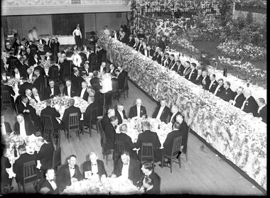
Photograph, Bull, Hugh Jones, 1897-1993, Lord Mayor's Dinner, Melbourne Town Hall
... After the separation of the colony in 1851, he became Victoria’s first surveyor-general... and advocated the provision of three-chain (60 m) roads and the widening of all existing main roads from one (20 m) to three chains." ...After the separation of the colony in 1851, he became Victoria’s first surveyor-general... and advocated the provision of three-chain (60 m) roads and the widening of all existing main roads from one (20 m) to three chains." ...Photographer notations on slide: "General View Of Lord Mayor's Dinner At Town Hall Nov 1936 B112" Published: The Age, Tuesday 10 November 1936, page 13 Published title: LORD MAYOR'S BANQUET Published caption: The brilliant scene inside the Melbourne Town Hall last night during the Lord Mayor’s banquet. Trove article identifier: http://nla.gov.au/nla.news-article205939431 Description: 700 guests (all men) are seated around numerous tables in the Melbourne Town Hall for the Lord Mayor's dinner in November 1936. Before the stage is a top table of 35 men, all dressed smartly in black dinner suits, with either a black or white bow tie. Many are wearing their medals. The Lord Mayor has on his Mayoral chains, and to his right is the Governor of Victoria, Lord Huntingfield. The stage is heavily decorated with fresh flowers. Research by project volunteer, Louise McKenzie: This image takes up one quarter of the photographic space on page 13 of The Age on 10 November 1936, reflecting the importance of the event and also the sheer dramatics of the image: 700 guests (all men), a top table of 35, and all dressed smartly in black dinner suits, with either a black or white bow tie. Many are wearing their medals. The Lord Mayor has on his Mayoral chains, and to his right is the Governor of Victoria, Lord Huntingfield. Further to his right is a man with an impressive sash across his chest. It is a very animated, and rather informal, moment. Banks of fresh flowers smother the stage, which is decorated in the manner of a terrace at an English stately home. Tables are laden with food, drink and decorations, and the wait staff (men and women) are also formally dressed, in the manner of Downton Abbey. It is spectacular, dramatic, and luxurious, and perpetuates the proud descriptor of “Marvellous Melbourne” as conferred by London Journalist George Augustus Sala when he visited the city in 1885. During its 1880s boom, Melbourne was the second-largest city in the British Empire, after London, and reputedly the richest city in the world. At times the expression was used with some irony, but "...in Victoria’s centenary year, 1934, with the city mired in another depression, a publisher bravely entitled a book of souvenir photographs Marvellous Melbourne, claiming that the subject ‘still finds apt expression in the happy one-time sobriquet’.” This photo seems to reflect an ongoing pride in Melbourne and a desire for it to live up to its descriptor and celebrate its post-centenary era in style. So it is no surprise to find that on page 11 of The Age on the same day, a second photo is to be found – a cropped view of one table – along with a very detailed description of the night, its purpose, and a surprise announcement. But, who was the Lord Mayor in whose honour the dinner was held? In 1934, the Lord Mayor of Melbourne was Cr. Alexander George Wales, (born Richmond, 11 October 1885, died Elsterwick, 31 May 1962). His father was a contractor and quarry-owner, but was blinded in an industrial accident in 1899. Consequently Alexander, then aged 14, left Brunswick State School to become a railway labourer working at a quarry, and in 1903 joined the Commonwealth public service as a clerk and began studying at night school, determined to improve himself. In 1907 he was appointed secretary of the Albion Quarrying Co. (in which the family had an interest), then its managing director and chairman. As the Australian Dictionary of Biography notes, he was instrumental in expanding the company’s interests, "...becoming director of the Hardware Co. of Australia Pty Ltd, the Twentieth Century Building and Investment Society, the Albion Sand Co. and the Geelong Brick Co.”. His public career began in 1914 when he was elected to the Brunswick council. He was mayor 1917-18, and in 1925 progressed to the Melbourne City Council where he remained for 29 years, being a member of most council committees. He served three successive terms as lord mayor (1934-37), was Chairman of the council’s decorations committee for Melbourne’s centenary, president of the Metropolitan Fire Brigades Board (1936), and Chairman of the Public Works Committee (1937-39). In 1936 he was elected to the Legislative Council with United Australia Party support, but later resigned over possible State government contract tender irregularities. Wales received "the customary reward” of a knighthood and was invested at Buckingham Palace by King George VI whose coronation he attended in 1937. He was an early director of what is now Ampol, and helped the development of the petroleum industry in Australia after visiting the USA in 1943 and 1946. He was impressed by that country’s wartime shipbuilding efforts and supported closer ties with the USA. “While president (1947-48) of the Melbourne Chamber of Commerce, Wales was a vocal critic of the Federal Labor Government, ...a staunch anti-socialist ... and a focus for conservative opposition to the Curtin and Chifley governments...” He is described as “a natural leader in business and civic politics,... a powerful force in the Melbourne City Council... opposing democratic reforms such as the creation of a Greater Melbourne Council and the abolition of plural voting, but advocat[ing] the redevelopment of city-owned property like the Eastern and Western markets...” So, this Lord Mayor’s dinner marks the third successive term in office for Governor Cr. A G Wales. The room is filled with powerful and influential men, and provided a platform for the Premier of Victoria, Albert Dunstan (1882-1950, United Country party) to announce that if the City Council would bear half the cost the State Government would build a bridge at Punt Road “at once”. He announced that the Government proposed to have the bridge built by the Country Roads Board, and allow the City Council to pay its share on convenient terms, and further, it would investigate the shared provision of more Yarra bridges. The proposal for the Punt Road Bridge was met with applause as the Yarra River constituted a serious traffic barrier. On 12 November 1936, two days after the Lord Mayor’s dinner, The Age published an article, “Building without a Plan”. It questions the appropriateness of the next Yarra bridge being the one at Punt Road, and encourages a “proper procedure” to look at the provision of additional Yarra bridges as a whole. But in fact this topic had been canvassed back in August when Melbourne City Council’s public works committee had recommended the replacement of the footbridge at Punt Road with a bridge, and if the Country Roads Board would declare this portion of Punt Road, including the river crossing, a State Highway, this could give the Board authority to construct the bridge and allocate the cost. Hence the reference at the dinner to a shared expense. Still an integral part of traffic management today, the Hoddle Bridge carries Punt Road over the Yarra River between Richmond and South Yarra in Melbourne. It is a five-lane road bridge with narrow footpaths on either side. It is of continuous reinforced concrete T-beam construction with five segmental arched spans, supported on transverse piers, and linked by concrete cross-beams. “The piers terminate in a series of tapered concrete pillars with Art Deco-styled steamlined decoration. Each pillar supports a Victorian-style lamp. The infill railings are geometric-patterned painted metal. Construction began in late 1937, and it was opened by Premier Albert Dunstan on 22 December 1938. It replaced an earlier footbridge, which in turn had replaced a punt service. The bridge (originally referred to as Punt Road Bridge) was named after Robert Hoddle, who planned central Melbourne’s Hoddle Grid, the grid of streets which form Melbourne’s central business district. Hoddle arrived in Australia from the UK in 1823 and went on to carry out surveys in NSW and Queensland before arriving in Melbourne in 1837. He designed layouts for both Melbourne and Williamstown, and later Geelong and other Victorian country areas. He was keen that major streets be at least 30 metres wide. ”With remarkable foresight he provided for wide boulevards from the city to the suburbs, but the subdivisions of early speculators in inner suburbs created the bottle-necks of today. After the separation of the colony in 1851, he became Victoria’s first surveyor-general... and advocated the provision of three-chain (60 m) roads and the widening of all existing main roads from one (20 m) to three chains." However, he was met with constant opposition and in 1853, was eased out of office. As a small and interesting aside: Hoddle was appointed auctioneer for the first sale of crown land in Melbourne on 1 June 1837. His commission was 57 pounds 12s 7d. and he bought two allotments for himself at a cost of 54 pounds. After he died his second wife married Richard Buckhurst Buxton, a member of the family which in 1860s Melbourne established the Australian property dynasty of Buxton Real Estate, Becton, MAB Corporation etc. Returning to the dinner and The Age article of 10 November 1836: Another topic of the after-dinner speeches was a reference to the upcoming Armistice Day. “The Minister of Customs (Mr White) said the proximity of Armistice day reminded us that eighteen years ago we had high hopes of prolonged peace.” The term “Armistice Day” was coined after WWI: “At 11 am on 11 November 1918, the guns on the Western Front fell silent after more than four years of continuous warfare. The Germans called for an armistice (suspension of fighting) in order to secure a peace settlement. They accepted the allied terms on unconditional surrender. Therefore on the 11th hour of the 11th day of the 11th month, a minute’s silence is observed and dedicated to those soldiers who died fighting to protect the nation. Originally known as Armistice Day, it was renamed Remembrance Day after World War Two to commemorate those who were killed in both World Wars. Today it refers to the loss of Australian lives from all wars and conflicts, accompanied by the words, "We will remember them, Lest we forget"." There was comment at the dinner about the need to remain firm in supporting the “democratic government in the British Empire to avoid a “plunge into savagery”. There was a grave responsibility on the British people to keep democracy alive, and that could not be done without adequate defence forces... Many weak governments in non-British countries had been swept aside by strong-fisted dictators, who now were the real threat to peace”. With the benefit of hindsight these were very pertinent comments and tragically prophetic. The Melbourne Shrine of Remembrance had only been dedicated two years earlier, at a ceremony attended by the Duke of Gloucester, son of King George V. Over 300,000 citizens attended: one third of the population of Melbourne. It became the location for the Anzac Day Dawn Service. Originally the march travelled from the Shrine into the city, however, in 1936, this was reversed, and the Shrine became the termination point for Anzac Day Marches. Also significant in 1936, was the installation of a statue in the west forecourt of the Shrine: “The Man with the Donkey” (aka 'Private John Simpson and his Little Donkey'). The work is said to represent the “valour and compassion of the Australian soldier”. Its full citation, according to the City of Melbourne City Collection is: West Side of Base: "The / Man with his Donkey / Gallipoli, April 25 to May 19 / in Commemoration / of the valour and compassion / of the Australian Soldier" AFTER LANDING AT GALLIPOLI, SIMPSON, WITH HIS LITTLE DONKEY, WORKED ALONE, DAY AND NIGHT TAKING WATER TO THE FRONT LINE AND CARRYING THE WOUNDED BACK TO THE DRESSING STATIONS. HE AND HIS DONKEY WERE KILLED BY A SHRAPNEL SHELL ON THE 19TH MAY, 1915. SIMPSON WAS MENTIONED IN DISPATCHES BY SIR IAN HAMILTON, COMMANDER-IN-CHIEF OF THE MEDITERRANEAN EXPEDITIONARY FORCE. / Erected by Public Subscription under auspices of the / Red Cross Society. East Side of Base: Private John Simpson." Their summary in background states: "A bronze figure of Simpson and his donkey with a wounded man on the donkey's back on a granite pedestal. Private John Simpson Kirkpatrick’s intrepid and short-lived exploits during the Gallipoli campaign have made him a popular figure of World War One. He has been mythologised to represent the lauded values of the digger, and he symbolises all those who went into battle unarmed. Born in England in 1892, he came to Australia in 1910. He enlisted to make his way back to England, but as a member of the 3rd Field Ambulance AIA was sent to Gallipoli. After just three weeks of bearing wounded soldiers across Shrapnel Gully on the back of his donkey, Simpson was killed by shrapnel fire. Simpson’s story became a powerful propaganda tool for enlistment in Australia, but following the war he was quickly forgotten. With the Shrine of Remembrance nearing completion in 1933, the memory of Simpson was rekindled to commemorate all who gave their lives to help others during the war. One plaque reads: ‘The / Man with his donkey / Gallipoli … / In commemoration / of the valour and compassion / of the Australian soldier’. In 1935, Wallace Anderson’s design for the memorial was selected though a competition organised by the Australian Red Cross. Anderson had served during the war and worked at the Australian War Memorial after his return. His Man with the Donkey was cast in Italy, and after some debate was sited near the shrine. Unveiled 20th June, 1936." The sculptor, Victorian-born William Wallace Anderson (1888-1975), served in France during WWI and afterwards produced a number of bronze war memorials and memorial portraits, predominantly in Victoria. “His most famous work is that of Simpson and his Donkey (1935), which he completed after winning a competition conducted by the Victorian Division of the Australian Red Cross. Anderson’s fee was 350 pounds; the cast, made by the Chiurazzi Foundry, Naples, Italy, cost 40 pounds. The work... has become well known as a symbol of the Anzac tradition.” A debate as to the siting of the statue arose from a strong view expressed by General Sir John Monash that no representation of individual members of the Australian Defence Force be located on the Shrine itself. Hence its location off to the northwest of the forecourt, in a garden of rosemary. And finally we return to the photo of the grand Lord Mayor’s dinner! An article in The Argus of 4 November 1936 refers to “Brilliant Scene at Lord Mayor’s Ball – Hall Becomes a Garden”. So now it becomes clear why the Town Hall, location of the Lord Mayor’s Dinner on 10 November 1934, only 6 days later, is so lavishly decorated. The floral decorations from the Ball are still in place - an early example of “recycling”, which is gratifying to note at a time of Depression. The reporter has captured the scene with enthusiasm: “Hundreds of tiny rose lights, hidden among pink roses, transformed the Melbourne Town Hall into a magical garden last night, when the Lord Mayor and Lady Mayoress (Councillor A. C. Wales, M.L.C., and Mrs. Wales) entertained about 3,500 guests at a ball. His Excellency the Governor (Lord Huntingfield) and Lady Huntingfield were present, while Rear-Admiral and Mrs. Lane Poole and officers from the visiting squadron were among the special guests. The balconies all round the hall were hidden by a white trellis, covered with pink blossoms and greenery. Rosy flowers were issued up every pillar, and great golden lamps, hanging from the door, were seated in greenery and trails of sweet peas. The organ gallery was converted into a terrace garden with stone steps leading to banks of pink azaleas, pink pelargoniums, masses of calceolarias, and the lovely deep mauve and blue of cinerarias. Slender Japanese maples and poplar trees grew from the higher slopes amid thickets of hostas, while a fascinating illusion was created by the lofty conservatory windows, which formed the background, and which were tinted cerulean blue to simulate the sky seen through glass. Large fern baskets hung from the conservatory roof, and the whole scene was enclosed in trellises of blossom. In the entrance palm green shrubs stood like sentinels round the passed floor, and flowers bloomed in misty golds. The long corridor upstairs leading to the council chamber was lined with an avenue of poplar trees in tubs. In the Lower Town Hall great banks of calceolarias and azaleas decked the upper dais, and each supper table was adorned with a different coloured flower with sprays of roses and Japanese maple laid on the snowy cloths. The adjoining supper-rooms were fragrant with the scent of huge bowls of stock in mauve, purple, and pink, while the white walls were covered with palm leaves and flowers. The roof garden below the clock tower was enclosed as a buffet with rose wreathed walls, and flowers were arranged attractively in the Lady Mayoress's rooms." References: LORD MAYOR'S BANQUET. CENTURY MAKERS AT THE M.C.G. BEFORE THE CHANGE. (1936, November 10). The Age (Melbourne, Vic. : 1854 - 1954), p. 13. Retrieved September 4, 2024, from http://nla.gov.au/nla.news-article205939431 'Portrait of Sir George Wales (Lord Mayor 1934-1937)', City Collection, City of Melbourne, https://citycollection.melbourne.vic.gov.au/portrait-of-sir-george-wales-lord-mayor-1934-37/ Graeme Davison, 'Marvellous Melbourne', eMelbourne, https://www.emelbourne.net.au/biogs/EM00906b.htm THE LORD MAYOR'S BANQUET. (1936, November 10). The Age (Melbourne, Vic. : 1854 - 1954), p. 11. Retrieved September 26, 2024, from http://nla.gov.au/nla.news-article205939643 BRILLIANT SCENE AT LORD MAYOR'S BALL Hall Becomes a Garden (1936, November 4). The Argus (Melbourne, Vic. : 1848 - 1957), p. 14. Retrieved September 26, 2024, from http://nla.gov.au/nla.news-article11932746 'Hoddle Bridge', Wikipedia, https://en.wikipedia.org/wiki/Hoddle_Bridge 'Hoddle Bridge', Victorian Heritage Database Report, Victorian Heritage Council, https://vhd.heritagecouncil.vic.gov.au/places/195689/download-report David Dunstan, 'Wales, Sir Alexander George (1885–1962)', Australian Dictionary of Biography, National Centre of Biography, Australian National University, https://adb.anu.edu.au/biography/wales-sir-alexander-george-8951/text15737, published first in hardcopy 1990, accessed online 26 September 2024. Marjorie J. Tipping, 'Hoddle, Robert (1794–1881)', Australian Dictionary of Biography, National Centre of Biography, Australian National University, https://adb.anu.edu.au/biography/hoddle-robert-2190/text2823, published first in hardcopy 1966, accessed online 26 September 2024. BUILDING WITHOUT A PLAN. (1936, November 12). The Age (Melbourne, Vic. : 1854 - 1954), p. 8. Retrieved September 26, 2024, from http://nla.gov.au/nla.news-article205949762 NEW BRIDGE AT PUNT ROAD (1936, August 12). The Argus (Melbourne, Vic. : 1848 - 1957), p. 10. Retrieved September 26, 2024, from http://nla.gov.au/nla.news-article11902131 'The Shrine of Remembrance', Beaconsfield’s Soldiers: https://beaconsfield.org.au/digitalmemorial/shrine-introduction/ 'Shrine of Remembrance', Wikipedia, https://en.wikipedia.org/wiki/Shrine_of_Remembrance Ken Scarlett, 'Anderson, William Wallace (1888–1975)', Australian Dictionary of Biography, National Centre of Biography, Australian National University, https://adb.anu.edu.au/biography/anderson-william-wallace-9362/text16441, published first in hardcopy 1993, accessed online 26 September 2024. 'Man with the Donkey', City Collection, City of Melbourne, https://citycollection.melbourne.vic.gov.au/man-with-the-donkey-aka-private-john-simpson-and-his-little-donkey/ 'Remembrance Day', Australian Army, https://www.army.gov.au/about-us/history-and-research/traditions/remembrance-day Photographer notations on slide: "General View Of Lord Mayor's Dinner At Town Hall Nov 1936 B112".melbourne town hall, mayors, lord mayors, centenaries, bridges, dinners, clothing and dress, festive decorations, dances and balls, eating and drinking, shrine of remembrance, governors, monuments and memorials, 1930-1939, plants -
 Williamstown Historical Society Inc
Tool - Surveyors tape measure
... chain. One side of the tape is marked in inches and the reverse side is marked in links Tool Surveyors tape measure ...Early surveying, especially for measuring land was often done in links. One link equated to 7.92 inches long, which is 20.12 centimeters, or one percent of a chain, which is 66 feet, or 2,011 centimetres long.A vintage Rabone tape measure in a brown leather case with a brass winding handle.The tape has a length of 66 feet, the length of a chain. One side of the tape is marked in inches and the reverse side is marked in linksOn the tape: "John Rabone & Co Hockley Made in England" -
 Bendigo Historical Society Inc.
Document - WES HARRY COLLETION: SURVEYORS MAP ON LINEN OF HONEYSUCKLE AND THISTLE STREETS
... A surveyor's map to scale 4 chains to 1 inch of Honeysuckle & Thistle Streets, between Alley Street and Clark Street. ...Wes Harry Surveyors map Honeysuckle street Thistle Street A surveyor's map to scale 4 chains to 1 inch of Honeysuckle & Thistle Streets, between Alley Street and Clark Street. ...A surveyor's map to scale 4 chains to 1 inch of Honeysuckle & Thistle Streets, between Alley Street and Clark Street. Section of map is overlaid in pink. Unknown purpose of the plan - undatedwes harry, surveyors map, honeysuckle street, thistle street