Showing 78 items matching "trench map"
-
 Bendigo Military Museum
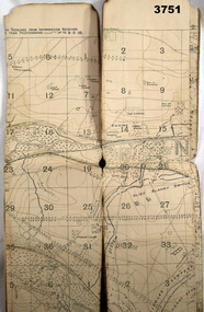
Map - TRENCH MAP, WW1, c. 1918
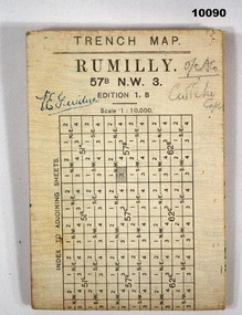
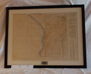
... TRENCH MAP, WW1......Trench Map...Detailed trench map of locality to Guide and plan Defence and operations. ...Large white hard paper map of Rumilly Trenches with Town of Rumilly, Masneriei and Crevecoeur and The Canal, St Quentin. ... TRENCH MAP, WW1 ...Detailed trench map of locality to Guide and plan Defence and operations. Part of the collection of V E Giudice 53730. Refer to Cat. No. 10031P for his details. Part of the overall William (Bill) Thomason Collection.Large white hard paper map of Rumilly Trenches with Town of Rumilly, Masneriei and Crevecoeur and The Canal, St Quentin. Full contour lines marked and showing the Beaurevoir Line of Trenches. Is to scale of 1:10,000. Mainly blank on back except a table to index adjoining sheets and a glossary of locations. Translation from French to English.Signed on front "V E Giudice" and "O/C ACO and something indecipherable.v e giudice, collection of william (bill) thomason, trench map, ww1 -
 Bendigo Military Museum
Map - TRENCH MAP, FRANCE WW1, 1918
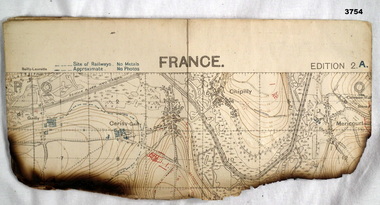
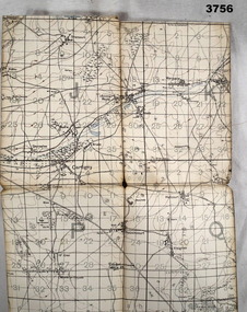
... TRENCH MAP, FRANCE WW1...Map...trench...Trench map, France, Edition 2A, sheet 62D S.E, scale 1:20,000, trenches corrected to 22.4.1918, trenches in red. ...Map TRENCH MAP, FRANCE WW1 ...Areas covered on this map, “Hamel, Mericourt, Proyart, Weincourt, Harbonnieres”. Item re William Alexander No 502 AIF. Refer Cat No 3746.3 for his service details.Trench map, France, Edition 2A, sheet 62D S.E, scale 1:20,000, trenches corrected to 22.4.1918, trenches in red. On outside in blue handwriting “62D S.E”map, trench, france -
 Bendigo Military Museum
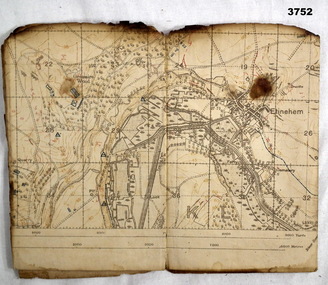
Map - TRENCH MAP, FRANCE WW1, 1916
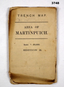
... TRENCH MAP, FRANCE WW1...Map...trench...Trench map, France, Area of Martin Puch, scale 1:20,000 Edition B, trenches corrected to 24.7.1916, enemy trenches in red....Map TRENCH MAP, FRANCE WW1 ...Areas covered by this map are, “Longueval, Delville Wood, Flers, Thiepval”. Item re William Alexander No 502 AIF. Refer Cat No 3746.3 for his service details.Trench map, France, Area of Martin Puch, scale 1:20,000 Edition B, trenches corrected to 24.7.1916, enemy trenches in red.map, trench, france -
 Tramways/East Melbourne RSL Sub Branch - RSL Victoria Listing id: 27511
Map and Legend, Trench Map - France Sheet 36 N.W
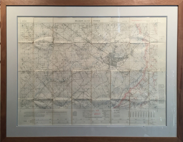
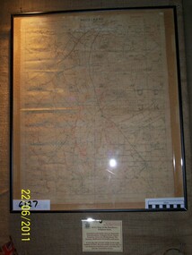
... Trench Map - France Sheet 36 N.W......trench map...It is an ordinance survey map of the trenches in the area. It is framed in two pieces, one being the main map and the other the legend used to read the map. ...It details the river 'La Lys Riviera' and the city 'Armentieres', in the Somme. Trench Map - France Sheet 36 N.W Map and Legend ...This is an actual battle map used by Australian Forces in the battle of the Somme in France in April 1917. It is an ordinance survey map of the trenches in the area. It is framed in two pieces, one being the main map and the other the legend used to read the map. It details the river 'La Lys Riviera' and the city 'Armentieres', in the Somme. somme, trench map, ww1, belgium, france, armentieres, 1917, ordinance survey map -
 Bendigo Military Museum
Map - TRENCH MAP, FRANCE WW1, 1917
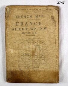
... TRENCH MAP, FRANCE WW1...Map...trench...Trench map, France, sheet No 57N.W. Edition6A, scale 1:20,000, trenches corrected to 7.2.1917, German trenches in red, on rear glossary of terms French to English....Refer Cat No 3746.3 for his service details. Map trench france Trench map, France, sheet No 57N.W. ...Main Australian areas on this map include “Grevillers, Bapaume and Fremicourt” Item re W.A Alexander No 502 AIF. Refer Cat No 3746.3 for his service details.Trench map, France, sheet No 57N.W. Edition6A, scale 1:20,000, trenches corrected to 7.2.1917, German trenches in red, on rear glossary of terms French to English.map, trench, france -
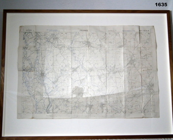
 Warrnambool RSL Sub Branch
TRENCH MAP, 1:20,000 FRANCE. Sheet 36 NW. Edition 6 B. GSGS 2742. Ordnance Survey 1916. Trenches corrected to 5/5/1916
... TRENCH MAP, 1:20,000 FRANCE. Sheet 36 NW. Edition 6 B. ...Warrnambool RSL Sub Branch Cnr Merri & Liebig Streets Warrnambool great-ocean-road Snape Collection TRENCH MAP, 1:20,000 FRANCE. Sheet 36 NW. Edition 6 B. ...snape collection -
 Bendigo Military Museum
Map - TRENCH MAP, FRANCE WW1, 1917
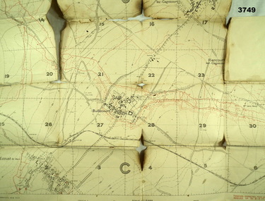
... TRENCH MAP, FRANCE WW1...Map...France...trench...Trench map, France, scale 1:10,000, German trenches in red, trenches corrected to 6.4.1917, Edition 2....Map TRENCH MAP, FRANCE WW1 ...Areas covered on this map are, “Bullecourt, Reincourt, Hendecourt”. Item relates to William Alexander No 502 AIF. Refer Cat No 3746.3 for his service details.Trench map, France, scale 1:10,000, German trenches in red, trenches corrected to 6.4.1917, Edition 2.map, france, trench -
 Bendigo Military Museum
Map - TRENCH MAP, FRANCE WW1, 1918
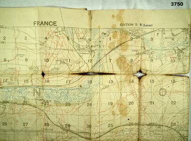
... TRENCH MAP, FRANCE WW1...Map...France...trench...Trench map, France, Edition 3B, trenches corrected to 7.7.1918, German trenches in red, British in blue, scale 1:20,000....Map TRENCH MAP, FRANCE WW1 ...Areas covered on this map “Corbie, Villers Brettoneux, Hangard, Blangy and Tronville Wood, River Somme”. Item re William Alexander No 502 AIF. Refer Cat No 3746.3 for his service details.Trench map, France, Edition 3B, trenches corrected to 7.7.1918, German trenches in red, British in blue, scale 1:20,000.map, france, trench -
 Bendigo Military Museum
Map - TRENCH MAP, FRANCE WW1, 1918
... TRENCH MAP, FRANCE WW1...Map...France...trench...Trench map, France, Edition 2A, sheet 62D N.W, scale 1:20,000, trenches corrected to 7.5.1918, British trenches in blue....Map TRENCH MAP, FRANCE WW1 ...Areas covered on this map, “Coisy, Allonville, Busy, Franvillers” Item re William Alexander No 502 AIF. Refer Cat No 3746.3 for his service details.Trench map, France, Edition 2A, sheet 62D N.W, scale 1:20,000, trenches corrected to 7.5.1918, British trenches in blue.On outside drawn in purple “62D N.W 1:20,000”map, france, trench -
 Bendigo Military Museum
Map - TRENCH MAP, FRANCE WW1, 1918
... TRENCH MAP, FRANCE WW1...Map...France...trench...Trench map, France, Edition 2A, sheet 62D S.W, scale 1:20,000, British trenches in blue, trenches corrected to 9.5.1918....Map TRENCH MAP, FRANCE WW1 ...Areas covered on this map “Corbie, Villers Brettoneaux, Hangard Wood, Aubigney, River Somme”. Item re William Alexander No 502 AIF. Refer Cat No 3746.3 for his service details.Trench map, France, Edition 2A, sheet 62D S.W, scale 1:20,000, British trenches in blue, trenches corrected to 9.5.1918.map, france, trench -
 Bendigo Military Museum
Map - TRENCH MAP, FRANCE WW1, 1918
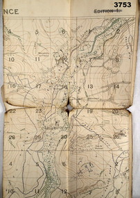
... TRENCH MAP, FRANCE WW1...Map...France...trench...Trench map, France, Edition 2 E, sheet 62D N.E, scale 1:20,000, trenches corrected to 28.5.1918, German trenches in red, British in blue....Map TRENCH MAP, FRANCE WW1 ...Areas covered on this map, “Ribemont, Morlancourt, Dernacourt, Fricourt, Mericourt, Saily Le Sec” Item re William Alexander No 502 AIF. Refer Cat No 3746.3 for his service details.Trench map, France, Edition 2 E, sheet 62D N.E, scale 1:20,000, trenches corrected to 28.5.1918, German trenches in red, British in blue.map, france, trench -
 Bendigo Military Museum
Map - TRENCH MAP, FRANCE WW1, FRAMED
... TRENCH MAP, FRANCE WW1, FRAMED...Trench map of France - Edition 5A Bellicourt - Montbrahain - Bran Court. ...Map stuck on white background. German trenches in blue. Map TRENCH MAP, FRANCE WW1, FRAMED The Union Studio The Union Studio ...Belonged to JOHN WILLIAM GRINTON No 1043 C Coy 38th Batt AIF. Refer Reg No 1280 for Service Details also 1317P, 1319P. Refer 1634P for the story on the map.Trench map of France - Edition 5A Bellicourt - Montbrahain - Bran Court. Tan, wooden frame, glass front with white cardboard backing. Hanging wire attached at back with centre strengthening brace. Map stuck on white background. German trenches in blue. Top middle: France. RHS bottom rear: The Union Studio - Castlemaine sticker.documents - maps, frame accessories, military history - army -
 Whitehorse Historical Society Inc.
Map, Area map of France trench map, 03/02/1918
... Area map of France trench map...WW1 Allied map of German trenches...Scale 1 : 20,000 Area map of France trench map Map ...Coloured trench map of part of France Sheet 62B S.W. Scale 1 : 20,000non-fictionColoured trench map of part of France Sheet 62B S.W. Scale 1 : 20,000maps, world war 1914 - 1918 -
 Rye RSL Sub Branch
Map Trench waterproofed cloth
... Map Trench waterproofed cloth...A waterproofed cloth trench map of the Becelaere area, including Polygon Wood and other severely contested areas....Map Trench waterproofed cloth ...A waterproofed cloth trench map of the Becelaere area, including Polygon Wood and other severely contested areas. -
Whitehorse Historical Society Inc.
Map - WW1 Trench map, Belgium collected by C H Honybun, Belgium WW1 map, Aug 1917
... WW1 Trench map, Belgium collected by C H Honybun...Sheet 28 S.W. and S.E. with trenches in red around the towns of Comines and Warneton Belgium WW1 map Map WW1 Trench map, Belgium collected by C H Honybun WW1 Ordnance ...WW1 map of Belgium Edition 1. Sheet 28 S.W. and S.E. with trenches in red around the towns of Comines and Warnetonnon-fictionWW1 map of Belgium Edition 1. Sheet 28 S.W. and S.E. with trenches in red around the towns of Comines and Warnetonworld war 1914 - 1918, maps -
Whitehorse Historical Society Inc.
Map - WW1 Trench map, Belgium collected by C H Honybun, Belgium WW1 map Edition 3, Nov 1917
... WW1 Trench map, Belgium collected by C H Honybun...Whitehorse Historical Society Inc. 2-10 Deep Creek Road Mitcham melbourne Area includes Comines, Warneton and Wervicq-sud Scale 1 : 20,000 World War 1914 - 1918 Maps WW1 map of Belgium Edition 3 Sheet 28 S.W. and S.E. Trenches in red Lettering in left margin Belgium WW1 map Edition 3 Map WW1 Trench map, Belgium collected by C H Honybun WW1 Ordnance ...WW1 map of Belgium Edition 3 Sheet 28 S.W. and S.E. Trenches in rednon-fictionWW1 map of Belgium Edition 3 Sheet 28 S.W. and S.E. Trenches in redworld war 1914 - 1918, maps -
 Bendigo Military Museum
Memorabilia - TRENCH ART, AUSTRALIA MAP, C. 1918
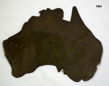
... TRENCH ART, AUSTRALIA MAP...Memorabilia TRENCH ART, AUSTRALIA MAP ...Regarding P Sexton. There is a Patrick Sexton listed in the 59th Batt roll No 3243a. The trench art was in the collection of James Worland Mills No 3441 59th Batt AIF. Refer 169P, 166.3, 167.6. Map of Australia made from spent munitions brass; engraved with picture of soldier holding a banner.'59th Btn.' - written on Union Jack in corner of banner. 'Australia for Ever' written on 2nd banner. 'CD' written between soldier's feet. Other inscriptions: 'France 12.7.18', and 'P. Sexton Ville-Sur Ancre Somme.arms-ammunition, trench art -
 Bendigo Military Museum
Memorabilia - TRENCH ART, AUSTRALIA MAP, Post 1941
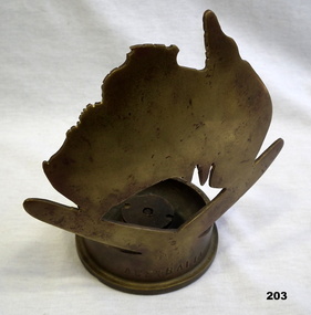
... TRENCH ART, AUSTRALIA MAP...Memorabilia TRENCH ART, AUSTRALIA MAP ...Brass map of Australia on top of a brass boomerang, which is attached to a brass 6 pdr. shell case on the outside circular base of the casing."AUSTRALIA" on side of casing. On shell base: 6 Pr 10 cwt 11, LOT 197, RL kn 1941 CFornaments, military history, trench art -
 Running Rabbits Military Museum operated by the Upwey Belgrave RSL Sub Branch
Map St Quentin
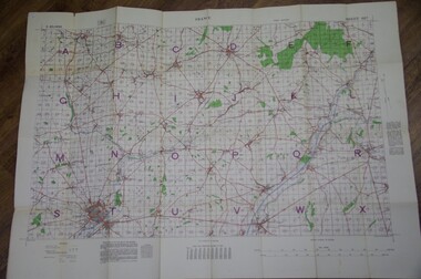
... Trench Map France Sheet 62Bshowing area around St Quentin....Running Rabbits Military Museum operated by the Upwey Belgrave RSL Sub Branch 1 Mast Gully Road Upwey melbourne Documents WW1 Army Trench Map France Sheet 62Bshowing area around St Quentin. ...Trench Map France Sheet 62Bshowing area around St Quentin.documents, ww1, army -
 4th/19th Prince of Wales's Light Horse Regiment Unit History Room
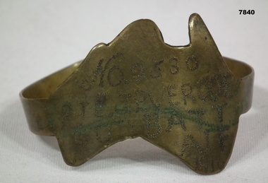
Souvenir - Trench Art, Bracelet Metal Map of Australia with leather strap, Mid 1917
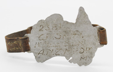
... Trench Art, Bracelet Metal Map of Australia with leather strap... Hand made metal map of Australia with brown leather band hand stitched and brass metal buckle Souvenir Trench Art, Bracelet Metal Map of Australia with leather strap C.W. ...Wrist badge for self identifiaction made by 2381 C.W. Smith as Trench Art during service in WW1Manufactured during WW1 by C.W. Smith as an item of identification in case of an adverse occurrence during his operational serviceHand made metal map of Australia with brown leather band hand stitched and brass metal buckle“2381 C.W.SMITH/1ST FIELD SQDN./A.N.Z. MTD DIV M.” Inscribed on front of metal mapwrist, badge, metal -
 Bendigo Military Museum
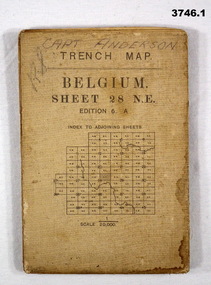
Map - TRENCH MAPS, BELGIUM WW1, 1) 1917; .2) & .3) 1916
... .1) Trench Map, Belgium, sheet 28 NE Edition 6A, folding, scale 1.20,000, trenches corrected to 3.7.1917, German trenches in red. ...Discharged from the AIF 18.9.1919. Maps trench .1) Handwritten on front: “CAPT ANDERSON” .1) Trench Map, Belgium, sheet 28 NE Edition 6A, folding, scale 1.20,000, trenches corrected to 3.7.1917, German trenches in red. ....1) Areas covered on this map include Zonnebeke, Broodseinde, Passchendaele, Westhoek, Glencorse Wood & Black Watch Corner. .2) Areas covered on this map include Bailleul, Neuve Eglise, Messines, Wyschaete, Warneton & Hollebeke. .3) Areas covered on this map include Poperinghe, Ypres, Dickebusch & Zillebeke. The maps are part of a collection of 27 collected by William Arthur ALEXANDER, No 502 AIF. He enlisted in the 8th reinforcements MG Coy 3 on 5.9.1916 aged 21 years. Embarked for England on 23.11.1916, transferred then to the 5th Div MG Coy. Embarked for France on 26.4.1917 then transferred to the 13th MG Coy on 16.6.1917. WIA 28.9.1917 gassed, he is later hospitalized with Colitis. Rejoined unit in the field 18.6.1918. Discharged from the AIF 18.9.1919..1) Trench Map, Belgium, sheet 28 NE Edition 6A, folding, scale 1.20,000, trenches corrected to 3.7.1917, German trenches in red. On rear glossary of terms French to English. .2) Trench Map, Belgium & France, sheet 28 SW Edition 3D, folding, scale 1.20,000, trenches corrected to 22.6.1916. German trenches in red, British in blue. On rear glossary of terms French to English. .3) Trench Map, Belgium, sheet 28 NW Edition 3D, folding, scale 1.20,000, trenches corrected to 25.6.1916. German trenches in red, British in blue. On rear glossary of terms French to English..1) Handwritten on front: “CAPT ANDERSON”maps, trench -
 Bendigo Military Museum
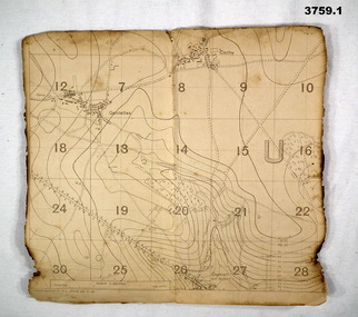
Map - FIELD SURVEY MAPS, FRANCE WW1, 1918
... Map...trench...Refer Cat No 3746.3 for his service details. Map trench France (.1 & .2) Both maps are same area, field survey 24.4.1918, scale 1:20,000. ...Areas covered on both, “Villers Brettoneaux, Cachy, Hangard, Gentelles”. Items re William Alexander No 502 AIF. Refer Cat No 3746.3 for his service details.(.1 & .2) Both maps are same area, field survey 24.4.1918, scale 1:20,000.map, trench, france -
 Bendigo Military Museum
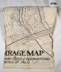
Map - BARRAGE MAP, FRANCE WW1, Possibly 1918
... Map...trench...Map, small section of a “Barrage map” showing objective lines with distances, enemy trenches are in blue. ...Refer Cat No 3746.3 for his service details. Map trench barrage Map, small section of a “Barrage map” showing objective lines with distances, enemy trenches are in blue. ...Villeret is centred within the areas of Rosiel, Bony, Bellicourt and Bellenglise. The map is possibly when the advance was into the Hindenburg Line in late 1918. Item re William Alexander No 502 AIF. Refer Cat No 3746.3 for his service details.Map, small section of a “Barrage map” showing objective lines with distances, enemy trenches are in blue. Top half and bottom half of the map are missing. Area covered appears to be “Villeret” scale 1:20,000map, trench, barrage -
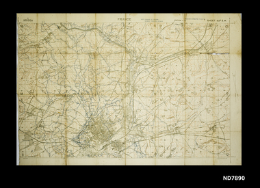
 Bendigo Military Museum
Map, 1917
... map...trench...Refer Cat No 3746.3 for his service details. map trench France Map, France, Ordnance survey May 1917, Edition 1, sheet 62c, scale possibly 1:20,000. ...Area of map covers the Somme from Suzanne, Clery, Perone then onto Doingt, Rosiel, Ronssoy. Item re William Alexander No 502 AIF. Refer Cat No 3746.3 for his service details. Map, France, Ordnance survey May 1917, Edition 1, sheet 62c, scale possibly 1:20,000. On rear is a glossary of terms French to English.map, trench, france -
 Ringwood RSL Sub-Branch
Trench Art WW2
... trench art map of Australia over a boomerang with kangaroo attached to face mounted on cut off bottom of centre fire 20mm shell case 1941 chrome finish ...Ringwood RSL Sub-Branch 16 Station Street Ringwood melbourne trench art map of Australia over a boomerang with kangaroo attached to face mounted on cut off bottom of centre fire 20mm shell case 1941 chrome finish Trench Art WW2. ...trench art map of Australia over a boomerang with kangaroo attached to face mounted on cut off bottom of centre fire 20mm shell case 1941 chrome finish -
 Bendigo Military Museum
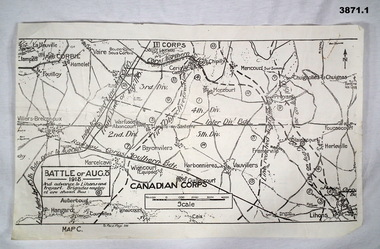
Map - TRENCH, BATTLE & ORDNANCE MAPS FRANCE WW1, All 1918
... (.1) Map on paper showing the “Battle of August 1918”, Map C, The Advance to “Lions & Proyart”. (.2) Trench map, gauze lined, sheet 62B N.W, trenches corrected to 8.2.1918, German trenches in blue, scale 1:20,000, France. (.3) Ordnance survey map, May 1918, France, Edition 1, sheet 62 E N.E, scale 1:20,000, a canal and river runs through the centre...August 1918 maps somme (.2) On rear hand written “62 B N.W” (.3) On rear hand written “D.M.F 62 E N.E” (.1) Map on paper showing the “Battle of August 1918”, Map C, The Advance to “Lions & Proyart”. (.2) Trench map, gauze lined, sheet 62B N.W, trenches corrected to 8.2.1918, German trenches in blue, scale 1:20,000, France. (.3) Ordnance survey map, May 1918, France, Edition 1, sheet 62 E N.E, scale 1:20,000, a canal and river runs through the centre Map TRENCH, BATTLE & ORDNANCE MAPS FRANCE WW1 ...(.2) Areas on map relate to : The Hindenburg line on the left, from the top, Bony to Bellicourt to Bellenglise, Estrees to Brancourt. (.3) The River Somme runs through from top corner left bottom corner right. Main areas are Belloy, Picquigny, Bertangles, Montieres. The map finishes just short of “Amiens” Items in the collection relating to F.A.W Hutson No 3539 AIF. refer Cat No 922 for his service history.(.1) Map on paper showing the “Battle of August 1918”, Map C, The Advance to “Lions & Proyart”. (.2) Trench map, gauze lined, sheet 62B N.W, trenches corrected to 8.2.1918, German trenches in blue, scale 1:20,000, France. (.3) Ordnance survey map, May 1918, France, Edition 1, sheet 62 E N.E, scale 1:20,000, a canal and river runs through the centre(.2) On rear hand written “62 B N.W” (.3) On rear hand written “D.M.F 62 E N.E”august 1918, maps, somme -
 Montmorency–Eltham RSL Sub Branch
Map - Framed 1915 Anzac Cove Map, Gallipoli, 1915.ANZAC Cove Map, 1915
... map...dardenelles...trench...A framed map depicting trench lines and the battlefields of the Gallipoli Campaign, 1915, made by the Survey Department Egypt. ...Montmorency–Eltham RSL Sub Branch Petrie Park 16 Mountain View Road Montmorency melbourne world war one anzac gallipoli 1915 anzac cove map dardenelles trench lines depth soundings landing areas Gallipoli - Anzac Cove World War One Map - 1915 A framed map depicting trench lines and the battlefields of the Gallipoli Campaign, 1915, made by the Survey Department Egypt. ...A framed map depicting trench lines and the battlefields of the Gallipoli Campaign, 1915, made by the Survey Department Egypt. Depth soundings of landing areas off Anzac Cove.Gallipoli - Anzac Cove World War One Map - 1915world war one, anzac, gallipoli, 1915, anzac cove, map, dardenelles, trench lines, depth soundings, landing areas -
 Warrnambool and District Historical Society Inc.
Book, The Journals of Major-Gen. C.G. Gordon, C.B. at Kartoum (sic), 1885
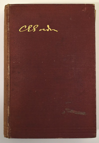
... maps, a portrait and thirty black and white illustrations. The Journals of Major-Gen. C.G. Gordon, C.B. at Kartoum (sic) Book Book A. Egmont Hake (editor); Kegan Paul, Trench ...Journals of General Gordon of KhartoumThis is a book of 316 pages, plus 33 pages of information on other books for sale by the publisher.The book has a dark red cover with gold lettering on the front cover and the spine. The pages contain printed text, two maps, a portrait and thirty black and white illustrations.non-fictionJournals of General Gordon of Khartoumgeneral gordon of khartoum, gordon, kartoum -
 Bendigo Military Museum
Memorabilia - TRENCH ART, BRACELET, C.1916
... Owners details engraved on the map. Memorabilia TRENCH ART, BRACELET ...Part of the Cooper Collection. "John Percy VERCOE", No. 2530, enlisted 18/5/16 in 5th Reinforcements, 60 BN. Aged 30 years. Embarked for England 25/9/1916, embarked for France 4/2/1917, WIA 26/4/1918. GSW to left eye, severe. Left eye excised England 30/4/1918. RTA 23/9/1918. Discharged from the AIF 4/1/1919. Passed away 30/12/1925. John received a Congratulatory card from MAJ.General J.H. Hobbs, K.C.B, V.D. Commanding 5th Aust. Division - for bravery and devotion to duty in dressing and carrying wounded to the Regt. Aid Post during a counter attack on Villers Brettoneux on the night of 24/25th April 1918.Brass map of Australia fashioned into a bracelet. Band is secured with a clip. Owners details engraved on the map.Engraved in the face of the map: 'No.2530, PTE J.P. VERCOE, 60TH BATT, AIF, 1916.cooper collection, trench art, john p. vercoe -
 Bendigo Military Museum
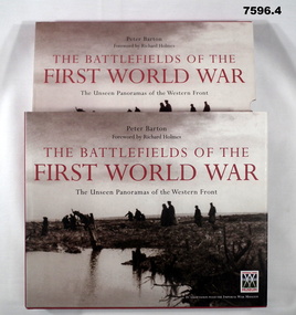
Book - BOOK, WW1, PICTORIAL, Peter BARTON, "THE BATTLEFIELDS OF THE FIRST WORLD WAR", 2005
... trench mats. Passchendaele". 376 pages, cut plain, white paper. Illustrated black and white, sepia and colour photographs, maps and diagrams. 2. ...trench mats. Passchendaele". 376 pages, cut plain, white paper. Illustrated black and white, sepia and colour photographs, maps and diagrams. 2. ...From front cover- "THE BATTLEFIELDS OF THE FIRST WORLD WAR". "The Unseen Panoramas of the Western front".Box with hard cover book, dust cover and two CD's. 1. Cover - cardboard, with adhered buckram, red colour, white print on spine. Dust cover - paper, with red, black and white print, front, spine and back. Illustrated, black and white photographs. Front cover - "German prisoners and wounded Canadians crossing the battlefield, Passchendaele 1917". Back cover - "Canadian soldiers carrying trench mats. Passchendaele". 376 pages, cut plain, white paper. Illustrated black and white, sepia and colour photographs, maps and diagrams. 2. Box for book - Cardboard, duplicate of print and photographs as per dust cover. Box is open one end. 3. & 4. CD's. - two, plastic CD's in clear plastic storage envelopes adhered to back and paper cardboard cover.books, ww1, pictorial