Showing 2914 items matching "victoria - maps"
-
 Sunshine and District Historical Society Incorporated
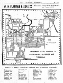
Map - Information Victoria Maps Albion Sunshine Maidstone Braybrook Maribyrnong with Street Names
... Information Victoria Maps Albion Sunshine Maidstone Braybrook Maribyrnong with Street Names...Phorocopies of 3 maps from Infomation Victoria Book Pages 490 & $91...Albion Sunshine Maidstone Braybrook Maribyrnong Map Information Victoria W.D. Flatman & Sons Pty Ltd Advert Phorocopies of 3 maps from Infomation Victoria Book Pages 490 & $91 Map Information Victoria Maps Albion Sunshine Maidstone Braybrook Maribyrnong with Street Names ...Information Victoria W.D. Flatman & Sons Pty Ltd Advertalbion, sunshine, maidstone, braybrook, maribyrnong, map -
 Wodonga & District Historical Society Inc
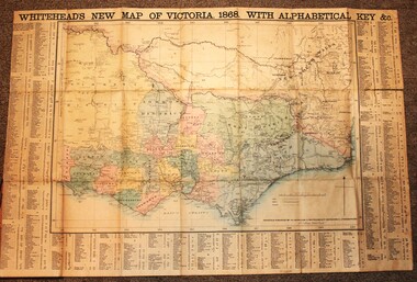
Map - Whiteheads New Map of Victoria, E. Whitehead & Co., engravers & lithographers, 1868
... Whiteheads New Map of Victoria ...Whiteheads New Map of Victoria ...Victoria Cartography...Rare maps...Whitehead founded his printing business at 67 Collins Street East in 1864 and, though not focused on maps, began publishing his own series of maps of Victoria in 1867. He focussed on producing highly detailed folding maps of Victoria which included a very detailed index of place names. ...A detailed early map of Victoria with counties clearly marked and shaded and a detailed index. ...Whiteheads New Map of Victoria Map Whiteheads New Map of Victoria E. ...Edward Whitehead was a printer and publisher active in Melbourne during the latter half of the 19th century. Whitehead founded his printing business at 67 Collins Street East in 1864 and, though not focused on maps, began publishing his own series of maps of Victoria in 1867. He focussed on producing highly detailed folding maps of Victoria which included a very detailed index of place names. His series of maps of Victoria became one of the most successful and most profitable series of regional maps of Australia ever produced.This is a very early map of Victoria showing Belvoir (Wodonga)A detailed early map of Victoria with counties clearly marked and shaded and a detailed index. It also shows roads, post office towns, railways, telegraphs, gold mining areas and notes on topography. Relief shown by hachures and spot heights. Includes a list of towns with distances from Melbourne on 3 sides of map. It is produced on paper mounted on linen.victoria cartography, rare maps victoria, whiteheads maps -
 Victorian Aboriginal Corporation for Languages
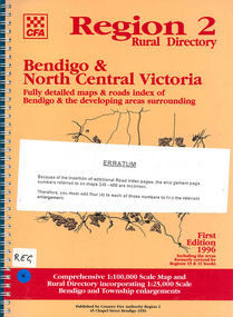
Map, Country Fire Authority, Region 2 rural directory : Bendigo &? North Central Victoria: fully detailed maps &? roads index of Bendigo &? the developing areas surrounding, 1996
... North Central Victoria: fully detailed maps &? roads index of Bendigo &? ...Victorian Aboriginal Corporation for Languages 33 Saxon Street Brunswick melbourne Bendigo Loddon fire protection Victorian regional maps directories maps Region 2 rural directory : Bendigo &? North Central Victoria: fully detailed maps &? ...mapsbendigo, loddon, fire protection, victorian regional maps, directories -
 Greensborough Historical Society
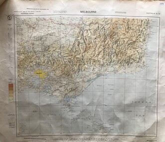
Map, Australia. Department of Minerals and Energy, Melbourne, topographic map, 1970_
... victoria - maps...A topographic map of Victoria with Melbourne as the centre. Provisional edition showing contours in feet. ...A pre-metric map, shows the Hume Highway travelling through towns such as Seymour and Benalla, now by-passed by the Hume Freeway. victoria - maps Map, printed in colour on one side. ...A topographic map of Victoria with Melbourne as the centre. Provisional edition showing contours in feet. International map of the world [scale] 1:1,000,000. Prepared by the Department of Minerals and Energy, Canberra in 1970.A pre-metric map, shows the Hume Highway travelling through towns such as Seymour and Benalla, now by-passed by the Hume Freeway.Map, printed in colour on one side.victoria - maps -
 Ringwood and District Historical Society
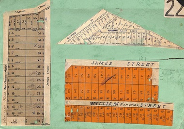
Card, Subdivision Maps - Ringwood, Victoria - (Undated, circa 1920s)
... Subdivision Maps - Ringwood, Victoria - (Undated, circa 1920s)...Subdivision Maps - Ringwood, Victoria - (Undated, circa 1920s) Card ...Collage of three residential allotment maps on green cardboard backing.Subdivisions include West Prussia Road, Wantirna Road, Station Street, James Street, Bedford Road, Williams Grove (later Lena Grove), and William Street (later Kendall Street), Ringwood. -
 Bacchus Marsh & District Historical Society
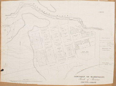
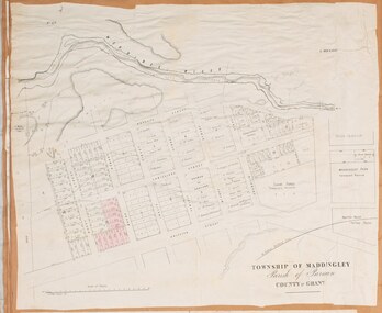
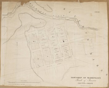
Map, Maddingley Township, Parish of Parwan, 1880s
... Bacchus Marsh Victoria Maps...Bacchus Marsh Victoria Maps Maddingley Victoria Maps Land Use Maddingley Victoria History Bottom of Map: Surveyor-General's Office, Melbourne, Sept 6th, 1856 A single page paper map showing land allotments, streets, rivers, creeks, park lands, the railway line and Bacchus Marsh railway station in the township of Maddingley. ...This map is dated Sept. 6th 1856. However places in the township of Maddingley which did not appear until the late 1880s such as the Bacchus Marsh Railway Station and line are shown on this map in their correct locations. This suggests the map has been derived from an earlier map. An earlier date of 1843 with a surveyor's name preceding it can also be seen on the map. The map is important because it indicates the location and dimensions of early but now discontinued use of land such as the showgrounds and police paddock and a site reserved for the Church of England which was not ultimately used for a permanent church. A single page paper map showing land allotments, streets, rivers, creeks, park lands, the railway line and Bacchus Marsh railway station in the township of Maddingley. The map is pasted into a bound volume containing 76 maps or plans in total. Bottom of Map: Surveyor-General's Office, Melbourne, Sept 6th, 1856bacchus marsh victoria maps, maddingley victoria maps, land use, maddingley victoria history -
 Bacchus Marsh & District Historical Society
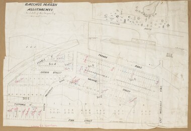
Map, Gaynor Street Land Sales, Maddingley, circa 1880s-1890s
... Bacchus Marsh Victoria Maps...Bacchus Marsh Victoria Maps Maddingley Victoria Maps Land Use Maddingley Victoria History Land Sales Bacchus Marsh Land Sales Maddingley A single page paper map showing land allotments for sale in the Maddingley area of Bacchus Marsh. ...This map was produced for a major sale of land in the Maddingley area of Bacchus Marsh. The precise date of the sale has not been determined. Features present on the map such as the Bacchus Marsh Railway Station indicate the land sale must have taken place some time after 1887 when the Railway Station opened. A single page paper map showing land allotments for sale in the Maddingley area of Bacchus Marsh. Locations shown include Gaynor Street, Maddingley Road South, Parwan Road, Mitchem Street, Typpynge Street, Finn Street and East Maddingley Road. . The map is pasted into a bound volume containing 76 maps or plans in total. High resolution digital image stored on BMDHS computer network. bacchus marsh victoria maps, maddingley victoria maps, land use, maddingley victoria history, land sales bacchus marsh, land sales maddingley -
 Bacchus Marsh & District Historical Society
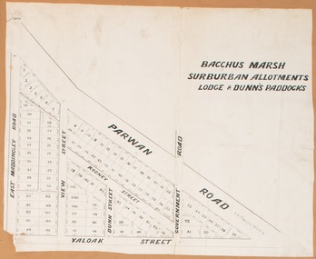
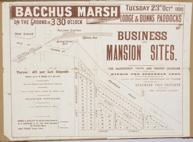
Map, Bacchus Marsh Suburban Allotments Parwan Road Lodge & Dunn's Paddocks 1888
... ...Bacchus Marsh Victoria Maps...Land Sales Bacchus Marsh Land Sales Maddingley Bacchus Marsh Victoria Maps Maddingley Victoria Maps A single page paper map showing allotments of land for sale along the Parwan Road in Maddingley. ...This map was created as a plan for an auction of land close to the Bacchus Marsh Railway Station. The auction took place on 23 October 1888. 102 allotments of land from an area known as Lodge and Dunn's paddocks was offered for sale. A single page paper map showing allotments of land for sale along the Parwan Road in Maddingley. The map is pasted into a bound volume containing 76 maps or plans in total. High resolution digital image stored on BMDHS computer network. land sales bacchus marsh, land sales maddingley, bacchus marsh victoria maps, maddingley victoria maps -
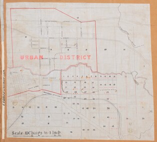 Bacchus Marsh & District Historical Society
Map, Bacchus Marsh Urban District
... Bacchus Marsh Victoria Maps...Bacchus Marsh Victoria Maps Maddingley Victoria Maps A single page paper map showing blocks of land in the urban district of Bacchus Marsh. ...The date of this map has not been established but the date would be sometime after 1887 as the Bacchus Marsh Railway Station, which opened in 1887, is shown on the map. A single page paper map showing blocks of land in the urban district of Bacchus Marsh. The 'urban district' is indicated by red drawn lines on the map and includes streets and blocks on the northern side of the Werribee River in Bacchus Marsh, and streets and blocks south of the Werribee in Maddingley. Scale 10 chains to 1 inch. The map is pasted into a bound volume containing 76 maps or plans in total. High resolution digital image stored on BMDHS computer network. bacchus marsh victoria maps, maddingley victoria maps -
 Bacchus Marsh & District Historical Society
Map, Limestone Reserve Parish of Merrimu 1888
... Bacchus Marsh Victoria Maps...Bacchus Marsh Victoria Maps Lime kilns Coimadai Limestone Coimadai Victoria Maps Alkemade Family Coimadai Copy of plan surveyed by Mr. ...Limestone deposits in the Coimadai area 10 kilometers north of Ballarat were first worked in the 1850s. The area was quarried for limestone for many years by various people and companies. The surveyor's name who produced this plan is inscribed on the map and below this is the name P. L. Alkemade, who presumably paid for the map to be produced. In 1886 Petrus Alkemade in partnership with Matthew Egan established the Alkemade Hydraulic Lime and Cement Company. The Alkemade family were involved in the limestone industry over several generations at Coimadai.Single page map showing part of the Limestone reserve near Coimadai in the Parish of Merrimu. Scale 4 chains to 1 inch. Part of a set of maps which are pasted into a bound volume containing 76 maps or plans in total. High resolution digital image stored on BMDHS computer network. Copy of plan surveyed by Mr. G? [illegible] an authorised surveyor on 17th July 1888. P. L. Alkemadebacchus marsh victoria maps, lime kilns coimadai, limestone, coimadai victoria maps, alkemade family coimadai -
 Bacchus Marsh & District Historical Society
Map, Gaynor Street Area Land Sales, Maddingley, 1888
... Bacchus Marsh Victoria Maps...Bacchus Marsh Victoria Maps Maddingley Victoria Maps Land Use Maddingley Victoria History Land Sales Bacchus Marsh Land Sales Maddingley A single page paper map showing land allotments for sale in the Maddingley area of Bacchus Marsh. ...This map was produced for a major sale of land in the Maddingley area of Bacchus Marsh in 1888. The sale was conducted by two firms from Melbourne, Carney and Kelly 12 Swanston Street Melbourne. and 'Richardson, Kerr & Co. 40 Flinders Lane Melbourne. 136 blocks were for sale.A single page paper map showing land allotments for sale in the Maddingley area of Bacchus Marsh. Locations shown include Gaynor Street, Maddingley Road South, Parwan Road, Mitchem Street, Typpynge Street, Finn Street and East Maddingley Road. . The map is pasted into a bound volume containing 76 maps or plans in total. High resolution digital image stored on BMDHS computer network. bacchus marsh victoria maps, maddingley victoria maps, land use, maddingley victoria history, land sales bacchus marsh, land sales maddingley -
 Bacchus Marsh & District Historical Society
Map, Maddingley Township, Parish of Parwan, circa 1890s
... Bacchus Marsh Victoria Maps...Bacchus Marsh Victoria Maps Maddingley Victoria Maps Land Use Maddingley Victoria History A single page paper map showing land allotments, streets, rivers, creeks, park lands, the railway line and Bacchus Marsh railway station in the township of Maddingley. ...Maddingley is a locality or township within the broader township area of Bacchus Marsh. This map is not dated. However features in Maddingley which appeared in the 1880s and 1890s are present in the map, These include the Bacchus Marsh Railway Station and the Bacchus Marsh Showgrounds. The main residential and commercial area of Maddingley is shown on this map in an area bounded by Bacchus Street, Barry Street, Griffith Street and Maddingley Road. Other streets visible are Franklin Street, Inglis Street, Labilliere Street, McCrae Street, Moore Street and part of Station Street.A single page paper map showing land allotments, streets, rivers, creeks, park lands, the railway line and Bacchus Marsh railway station in the township of Maddingley. The map is pasted into a bound volume containing 76 maps or plans in total. bacchus marsh victoria maps, maddingley victoria maps, land use, maddingley victoria history -
 Bacchus Marsh & District Historical Society
Map, Maddingley Township, Parish of Parwan, County of Grant, 1856
... Bacchus Marsh Victoria Maps...Bacchus Marsh Victoria Maps Maddingley Victoria Maps Land Use Maddingley Victoria History Two inscriptions: 1. ...Maddingley is a locality or township within the broader township area of Bacchus Marsh. This map is dated 1856 but is based on an earlier survey in 1843. The main area of Maddingley shown on this map is an area bounded by Bacchus Street, Moore Street, Griffith Street and Franklin Street. Other streets visible are Inglis Street, Labilliere Street, McCrae Street. The area to the east of Franklin Street is not sub-divided and is described as an 'alluvial flat. A single page paper map showing land allotments, streets, and natural watercourses in the township of Maddingley. The map is pasted into a bound volume containing 76 maps or plans in total. Two inscriptions: 1. A.J. Skene Surveyor, 1843. ; 2. Surveyor-General's Office Melbourne, Sept 6, 1856. (Lithographed by R. Meikle)bacchus marsh victoria maps, maddingley victoria maps, land use, maddingley victoria history -
 Bacchus Marsh & District Historical Society
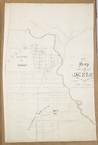
Map, 'Map of Darley' circa 1877-1897
... Darley Victoria Maps...Landholders names can be seen on some of the allotments of land marked in this map, including the names Clifton, Cosgrove, O'Hagan, McFarlane, Nagle, O'Hagan, Simpson and Vallence. Darley Victoria Maps Bacchus Marsh Victoria Maps A single page paper map showing the village of Darley and the township of Bacchus Marsh. ...This map shows the early laid out streets and roads for the village of Darley and the main roads and streets in the central area of the township of Bacchus Marsh. The date of the map is not known. Landmarks indicated on the map including the Anglican Church in Church Street (Gisborne Road), opposite the Presbyterian Church, and the Baptist Church at its pre-1898 Main Street location suggest the map is dated between 1877 and 1897. Landholders names can be seen on some of the allotments of land marked in this map, including the names Clifton, Cosgrove, O'Hagan, McFarlane, Nagle, O'Hagan, Simpson and Vallence.A single page paper map showing the village of Darley and the township of Bacchus Marsh. Scale 10 chains to 1 inch. The map is pasted into a bound volume containing 76 maps or plans in total. High resolution digital image stored on BMDHS computer network. darley victoria maps, bacchus marsh victoria maps -
 Bacchus Marsh & District Historical Society
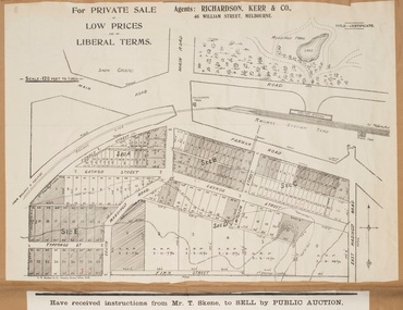
Map, Bacchus Marsh Tuesday 23rd Oct. 1888, Lodge & Dunn's Paddocks 1888. Business and Mansion Sites
... ...Bacchus Marsh Victoria Maps...Land Sales Bacchus Marsh Land Sales Maddingley Bacchus Marsh Victoria Maps Maddingley Victoria Maps At bottom on left side: 'Harston & Co. ...This map was created as a plan for an auction of land close to the Bacchus Marsh Railway Station. The auction took place on 23 October 1888. 102 allotments of land from an area known as Lodge and Dunn's paddocks was offered for sale. The auction was conducted by auctioneers based in Melbourne and was advertised in Melbourne newspapers as well as in the Bacchus Marsh Express newspaper. The auction plan contains a range of details including the selling agents, Munro and Baillieu; W.P. Lockhart; and John Turner, all of Melbourne, deposit terms for purchases, price of railway passes for a return trip from Melbourne to Bacchus Marsh of 1 shilling, and a description of the land as having 'magnificent views and perfect drainage'. A single page paper map showing allotments of land for sale along the Parwan Road in Maddingley. The map is pasted into a bound volume containing 76 maps or plans in total. High resolution digital image stored on BMDHS computer network. At bottom on left side: 'Harston & Co. Lith, Melb.'land sales bacchus marsh, land sales maddingley, bacchus marsh victoria maps, maddingley victoria maps -
 Kiewa Valley Historical Society
Maps of Victoria
... Maps of Victoria...maps of victoria...Hiscock & Co's, New Victoria Countries Atlas 1874'. 3. Map of the Murray and Gipps Land Distr' with handwritten: "Baillieu's County Atlas of Victoria 1866'....Maps of Victoria ...Three maps: copies from the 19th century. 1. Handwritten 'Dept of Lands & Survey 1876'. 2. Map of the Ovens & Murray District, Victoria with handwritten 'F.H. Hiscock & Co's, New Victoria Countries Atlas 1874'. 3. Map of the Murray and Gipps Land Distr' with handwritten: "Baillieu's County Atlas of Victoria 1866'.maps of victoria, 19th century, oven and murray district of victoria -
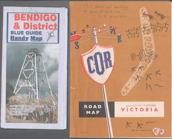 Bendigo Historical Society Inc.
Map - Road maps
... Map...Victoria...On, Bendigo & District blue guide handy map the other a road map of Victoria. ...On the back of the Bendigo map the date October 2000. On the Victoria map the words in pen "This doesn't belong to you, it is mine". ...On, Bendigo & District blue guide handy map the other a road map of Victoria. Map Road maps ...BHS CollectionTwo road maps. On, Bendigo & District blue guide handy map the other a road map of Victoria. On the back of the Bendigo map the date October 2000. On the Victoria map the words in pen "This doesn't belong to you, it is mine". L.J. Ellison and a blue stamp of Axedale service station. Aileen and John Ellison Collection.road map, victoria, bendigo -
 Phillip Island and District Historical Society Inc.
Book, F.E. Hiscocks &? Co, F.E. Hiscocks &? Co.'s new Victorian counties atlas, 1874 [cartographic material] : together with map of Victoria, indicating roads, distances, relative position of counties, &?c, 1874
... s new Victorian counties atlas, 1874 [cartographic material] : together with map of Victoria, indicating roads, distances, relative position of counties, &?...Victoria...maps...Phillip Island and District Historical Society Inc. phillip-island-and-the-bass-coast Victoria maps Labelled 'Cowes Free Public Library', 'Phillip Island Historical Society, Cleeland Bequest'. ...Labelled 'Cowes Free Public Library', 'Phillip Island Historical Society, Cleeland Bequest'.victoria, maps -
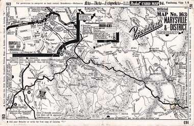 Marysville & District Historical Society
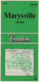
Ephemera (Item) - Pocket card map, Broadbent's Official Road Guides Company, Broadbent's Map No. 163 Marysville & District, 1950s
... ...victoria...maps...Broadbent's was a prolific publisher of maps. marysville victoria maps broadbent's barton's store marylands guest house A pocket card map of Marysville and the district. ...A pocket card map of Marysville and the district. Drawn map of Marysville and the district. Has a legend, scale and a town map of Marysville. Gives an address for Broadbent's Publishing Office of 475 Collins St Melbourne and a Melbourne telephone number - MR 2021. Reverse has advertisements for Barton's Store and Marylands Guest House in Marysville.A pocket card map of Marysville and the district. Gives information about Marysville and the district. Broadbent's was a prolific publisher of maps. marysville, victoria, maps, broadbent's, barton's store, marylands guest house -
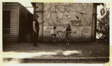 Marysville & District Historical Society
Photograph (Item) - Black and white photograph, 1949
... ...victoria...maps...A copy of a black and white photograph of an Atlantic Road Map of Marysville adhered to an unknown building in Marysville. marysville victoria maps atlantic road map A copy of a black and white photograph of an Atlantic Road Map of Marysville adhered to an unknown building in Marysville. ...A copy of a black and white photograph of an Atlantic Road Map of Marysville adhered to an unknown building in Marysville.A copy of a black and white photograph of an Atlantic Road Map of Marysville adhered to an unknown building in Marysville.marysville, victoria, maps, atlantic road map -
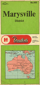 Marysville & District Historical Society
Ephemera (Item) - Tourist map, The Paul Hamlyn Group, Marysville District No. 163, 1950s
... ...victoria...maps...map of Marysville. Has an index of locations and their grid details. Gives details of addresses in New South Wales and Victoria for The Paul Hamlyn Group....A tourist map of Marysville and the district which was produced by Broadbent's, a division of The Paul Hamlyn Group. marysville victoria maps broadbent's the paul hamlyn group A tourist map of Marysville and the district which was produced by Broadbent's, a division of The Paul Hamlyn Group. ...A tourist map of Marysville and the district which was produced by Broadbent's, a division of The Paul Hamlyn Group. Drawn map of Marysville and the district. Has a legend, scale and a town map of Marysville. Has an index of locations and their grid details. Gives details of addresses in New South Wales and Victoria for The Paul Hamlyn Group.A tourist map of Marysville and the district which was produced by Broadbent's, a division of The Paul Hamlyn Group.marysville, victoria, maps, broadbent's, the paul hamlyn group -
 Marysville & District Historical Society
Ephemera (Item) - Tourist map, Lansdowne Press, Marysville District No. 163, Unknown
... ...victoria...maps...A tourist map of Marysville and the district which was produced by Broadbent's, a division of Lansdowne Press. marysville victoria maps broadbent's lansdowne press A tourist map of Marysville and the district which was produced by Broadbent's, a division of Lansdowne Press. ...A tourist map of Marysville and the district which was produced by Broadbent's, a division of Lansdowne Press. Drawn map of Marysville and the district. Has a legend, scale, and a town map of Marysville. Has an index of locations and their grid details. Shows a list of other maps in the Robinson's and Broadbent's range.A tourist map of Marysville and the district which was produced by Broadbent's, a division of Lansdowne Press.marysville, victoria, maps, broadbent's, lansdowne press -
 Kew Historical Society Inc
Book, Plan of General Development, Melbourne : Report of the Metropolitan Town Planning Commission
... City Planning -- Victoria. -- Maps...Kew Historical Society Inc Kew Court House 188 High Street Kew melbourne City Planning -- Victoria. -- Maps City Planning -- Victoria -- Melbourne city planning -- victoria Civic improvement -- Victoria -- melbourne Melbourne -- (vic.) cartography The 1929 report of the Metropolitan Town Planning Commission covering Melbourne and its suburbs. ...The 1929 report of the Metropolitan Town Planning Commission covering Melbourne and its suburbs. Includes photographs and 15 folding maps (some in rear pocket) This was a planning scheme to prevent 'misuse' of land and protect property values. It highlighted traffic congestion, the distribution of recreational open space and haphazard intermingling of land uses. The plan identified a number of problems, such as the congestion at St Kilda Junction, that were not addressed until decades later. The plan also recognised the value of Melbourne's waterways as an open space network.xii, 308 p., [25] leaves of plates (24 folded) : ill., maps (some col.), ports., plans ; 34 cm. CONTENTS Part 1 Surveys and studies Part II Communications Part III The execution of improvement schemes - a programme of urgent works Part IV Zoning Part V Public Recreation Part VI Public Utilities Part VII Housing and Land Subdivision Part VIII Civic Art and Amenities Part IX Miscellaneous Part X Legislation Part XI Conclusionnon-fictionThe 1929 report of the Metropolitan Town Planning Commission covering Melbourne and its suburbs. Includes photographs and 15 folding maps (some in rear pocket) This was a planning scheme to prevent 'misuse' of land and protect property values. It highlighted traffic congestion, the distribution of recreational open space and haphazard intermingling of land uses. The plan identified a number of problems, such as the congestion at St Kilda Junction, that were not addressed until decades later. The plan also recognised the value of Melbourne's waterways as an open space network.city planning -- victoria. -- maps, city planning -- victoria -- melbourne, city planning -- victoria, civic improvement -- victoria -- melbourne, melbourne -- (vic.), cartography -
![Map, Plan of Town Allotments Bacchus Marsh [1891-1897]](/media/collectors/5e461d8021ea67224c82f2a1/items/66acc1c90c778f9f64a3daec/item-media/66acc3990c778f9f64a3e09b/item-fit-380x285.jpg?cb=6) Bacchus Marsh & District Historical Society
Bacchus Marsh & District Historical SocietyMap, Plan of Town Allotments Bacchus Marsh [1891-1897]
... Bacchus Marsh Victoria Maps...Bacchus Marsh Victoria Maps Shops Bacchus Marsh A single page paper plan showing allotments of land fronting Lerderderg and Bennett Street. ...This plan of town allotments in Lerderderg Street and Bennett Street also includes the location of many of the buildings, shops, businesses and houses which were present in the retail and business area of Bacchus Marsh in the 1890s. The precise date of the plan is not known but it must be sometime between 1891 and 1897. The Post Office and the Wesleyan Church are both shown on this plan. Both of these were constructed in 1890. The plan does not show the Baptist Church in Main Street which was constructed in 1898. Hence the date is sometime between 1891 and 1897.This plan of Bacchus Marsh is one of the most detailed visual representations of the location of shops, businesses and houses in the central part of Bacchus Marsh. It provides very precise locations of most of the shops and houses in the town in the 1890s. A single page paper plan showing allotments of land fronting Lerderderg and Bennett Street. Buildings, businesses and houses along most of the streets are identified by hand written annotations. Streets identified on plan: Lerderderg Street - Bennett Street - Main Street - Gell Street - Young Street - Graham Street. Physical boundaries of the map are: North border - Lerderderg Street - South border - Main Street - West border Gell Street - East border - Young Street. The plan is pasted into a bound volume containing 76 maps or plans in total. bacchus marsh victoria maps, shops bacchus marsh -
 Bacchus Marsh & District Historical Society
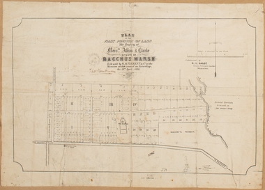
Map, Plan of the property of Messers Atkins and Clarke to be sold at the Mansion, Bacchus Marsh 19th April 1856. Copy 1
... Bacchus Marsh Victoria Maps...Bacchus Marsh Victoria Maps Bacchus Family Land Sales Manor House Bacchus Marsh Heading: Plan of the first portion of land. ...This plan of land allotments for sale indicates the property once owned by the Bacchus family in and around the township area of Bacchus Marsh. The Bacchus family sold their property in Bacchus Marsh to John Atkins and Robert Nalder Clarke in March 1851. Atkins and Clarke kept the property for a number of years until April 1856 when these allotments were put up for sale.This plan is almost identical to another copy held by the Bacchus Marsh and District Historical Society, VC Record 452, BMDHS collection). This plan, VC Record 707 Copy 1, contains a little more detail overall than VC Record 452 Copy 2, such as who did the survey work for the plan (R.C. Bagot) and who the selling agents were, (W.M. Tennent), and on the right side of the plan near the Lerderderg River is indicated the general area for a second parcel of land from this sale which is to be sold. There is also a compass illustration indicating north and south compass points.This is a very early land sales plan for the township of Bacchus Marsh and it therefore provides some clues as to how the early urban development of the township took place. Upon seeing the map in 1911 Bacchus Marsh Express newspaper editor Christopher Crisp wrote "The sale appears to have created the present township, which had a nucleus in earlier times further east", Express, 30 September, 1911, page 3.A single page paper plan showing allotments of land for sale. The subdivided land shown was owned by John Atkins and Robert Nalder Clarke, but previously owned by the Bacchus Family and was in and around their Manor House (Mansion) property in Bacchus Marsh.There are 5 portions of land further divided into numerous small portions. The land for sale is bounded by the present day streets of Main Street, Young Street, McFarland Street, Morton Streets, Crook Street, and part of the eastern section extends to the Lerderderg River. Scale: 8 chains to 1 inch The plan is pasted into a bound volume containing 76 maps or plans in total. BMDHS Loc: AR/B12/S4 Bacchus Marsh Township and Nearby Districts Maps Volume In-house Digital copies: BMDHS, Computer Network: Maps\Bacchus Marsh Township and Nearby Districts Maps VolumeHeading: Plan of the first portion of land. The property of Messers Atkins and Clarke situate at Bacchus Marsh. To be sold by W.M. Tennent & Co. at the Mansion on the Ground on Saturday the 19th April 1856. Below heading: Jas Ferguson, Lithographer On upper right side: Subdivided by R.C. Bagot London and Liverpool Chambers, Melbourne. 'Thos Taubman'. Post Office Stamp: BACCHUS MARSH VICTORIA MY 6, 63bacchus marsh victoria maps, bacchus family, land sales, manor house bacchus marsh -
 Bacchus Marsh & District Historical Society
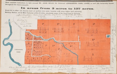
Map, Lerderderg Park Lands sale plan. 1911
... Bacchus Marsh Victoria Maps...Bacchus Marsh Victoria Maps Land Sales Lerderderg Park Estate Land Subdivision Top: Have received instructions to Sell, account Mr John Wills, his renowned LERDERDERG PARK LANDS, so well and favourably known throughout the Commonwealth. ...This plan was for the sale of parcels of land from the Lerderderg Park Estate property in 1911. Advertising for the sale appeared in the Bacchus Marsh Express newspaper through July of 1911. The property was situated only a few kilometers from the township of Bacchus Marsh. The agents for the sale were L. A. Fairbairn & Co.Lerderderg Park Estate was a significant and early colonial property in the Bacchus Marsh area. This plan provides details about the first time the property was subdivided for sale. It is therefore documents an important moment in the history of this property and the broader trend of the subdivision of older and larger properties in the district.A single page paper plan showing allotments of land for sale from the Lerderderg Park property owned by John Wills. The parcels of land for sale are coloured in red.The Lerderderg River and Pyke's Creek Irigation Channel shown on the plan are in blue ink. The rest of the plan is a dark cream or beige colur with the text in black ink. The plan has been extensively annotated with hand-written notes indicating the names of people who purchased the various parcels of lands and the prices paid for those lands. Part of the top of the plan containing some text appears to be missing. The plan is pasted into a bound volume containing 76 maps or plans in total. Top: Have received instructions to Sell, account Mr John Wills, his renowned LERDERDERG PARK LANDS, so well and favourably known throughout the Commonwealth. In areas from 3 acres to 1276 acres. Every lot is either rich lucerne land (or portion now under lucerne) with some higher land adjoining Railway Station, and 2 Milk factories within 2 miles, absolutely the finest land in Victoria. Bottom: THIS IS THE FIRST SUBDIVISIONAL SALE of Rich Flats in Bacchus Marsh since the Pyke's Creek Scheme, and every lot is commanded by it. Only 32 miles from Melbourne.bacchus marsh victoria maps, land sales, lerderderg park estate, land subdivision -
 Bacchus Marsh & District Historical Society
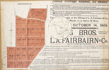
Map, Greystones Estate Land Sale 1909
... Bacchus Marsh Victoria Maps...map was produced sometime around mid 1909 to advertise portions of land from the Greystones Estate for sale by public tender. The selling agents were Young Brothers of Horsham and L.A. Fairbairn of Bacchus Marsh and Melbourne. The seller was Molesworth R. Greene who was a pioneer pastoralist in the Bacchus Marsh area and had also acquired other properties in Victoria...Bacchus Marsh Victoria Maps Land Sales Land Sales Bacchus Marsh Greystones Estate Bacchus Marsh Molesworth R. ...This map was produced sometime around mid 1909 to advertise portions of land from the Greystones Estate for sale by public tender. The selling agents were Young Brothers of Horsham and L.A. Fairbairn of Bacchus Marsh and Melbourne. The seller was Molesworth R. Greene who was a pioneer pastoralist in the Bacchus Marsh area and had also acquired other properties in Victoria and interstate. Molesworth Greene died in 1916 so this sale came towards the end of his life. A total of 4,176 acres was offered for sale in multiple lots. Successful tenderers could buy single or multiple lots. The results of the sale were reported in the Bacchus Marsh Express newspaper on the 16th October 1909, page 3. At the sale a total of 3, 420 acres was sold. A single page paper map showing portions of land for sale from the Greystones Estate near Bacchus Marsh. The map includes extensive details about the property, number of allotments for sale, terms and conditions of the sale and prices. The map includes an inserted reference map showing the location of the property in relation to Melbourne, Geelong, Ballarat and Castlemaine. The top of the map appears to be missing resulting in some loss of the text. The sale notice in the Bacchus Marsh Express of 10 July, 1909, page 3, column 1 appears to duplicate the text overall in the auction plan. Based on this the missing text is likely to be: "Important Subdivisional Sale 'Of Portion of One of the Best and Most Favourably known Estates IN THE RENOWNED BACCHUS MARSH DISTRICT. And situated only six miles from that prosperous township, two miles from Rowsley, and three miles from Parwan, all Railway towns, connected with the Estate by metal roads." Scale: 20 chains to 1 inch The map is pasted into a bound volume containing 76 maps or plans in total. bacchus marsh victoria maps, land sales, land sales bacchus marsh, greystones estate bacchus marsh, molesworth r. green 1827-1916, land sales rowsley -
 Bacchus Marsh & District Historical Society
Map, Bacchus Marsh Region Parish Plans: Folded set of maps
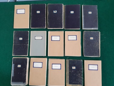
... ...Bacchus Marsh Victoria Maps...Bacchus Marsh & District Historical Society Lerderderg Library Main Street Bacchus Marsh Maps Bacchus Marsh Region Bacchus Marsh Victoria Maps Set of Victorian Lands Department Parish Plans covering the township of Bacchus Marsh and surrounding districts. ...Set of Victorian Lands Department Parish Plans covering the township of Bacchus Marsh and surrounding districts. Folded. BMDHS Location: AR/SU27/D2: Map Drawersmaps bacchus marsh region, bacchus marsh victoria maps -
 Bacchus Marsh & District Historical Society
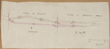
Map, Road plan deviation near Glenmore
... ...Glenmore Victoria Maps...Road Plans Road Construction Glenmore Victoria Maps Old road colored Yellow, New road colored Pink A single page paper map showing a plan for a road deviation near Glenmore Station. ...This plan shows a proposed deviation in the road near Glenmore. This is likely to have been the Bacchus Marsh to Ballan road. The precise date of the plan has not been established. Proposed deviations to the road near Glenmore appear in reports in the Bacchus Marsh Express newspaper through many decades, especially in the 1870s and 1880s. Glenmore is located 19 kilometers west of Bacchus Marsh.A single page paper map showing a plan for a road deviation near Glenmore Station. Scale 5 chains to 1 inch. Date of production unknown. Circa 1860s-1890s. The map is pasted into a bound volume containing 76 maps or plans in total. High resolution digital image stored on BMDHS computer network. Old road colored Yellow, New road colored Pinkroad plans, road construction, glenmore victoria maps -
 Bacchus Marsh & District Historical Society
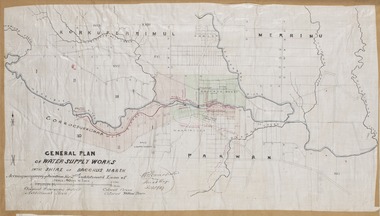
Map, General Plan for Water Supply Works, Shire of Bacchus Marsh 1887
... ...Bacchus Marsh Victoria Maps...Water Supply Water Supply Maps Water Supply Bacchus Marsh Irrigation Bacchus Marsh Victoria Maps General Plan of Water Supply Works in the Shire of Bacchus Marsh. ...Debate about water supply and its planning and development took place in the Bacchus Marsh region from the 1850s through into the twentieth century. This plan was part of documentation to support an application for an additional loan of money from the Ministry of Water Supply to the Bacchus Marsh Shire Water Supply Trust. The plan includes the route of a proposed water channel in the Parwan area, and other features of water supply infrastructure such as the location of standpipes and gates are also shown on the plan.A single page paper map showing a general plan for the supply of water in the Bacchus Marsh area.The plan shows the route of the 'Main Channel' near the Werribee River and a proposed route for a Parwan Channel. The location of 'Dryden's House' near the Werribee River is also shown and the locations of land held by T. (Tom) Oliver and the Racecourse Reserve in Maddingley. Scale 40 chains to 1 inch. The plan is signed by Bacchus Marsh Shire Engineer, W.E. Standfield. The map is pasted into a bound volume containing 76 maps or plans in total. High resolution digital image stored on BMDHS computer network. General Plan of Water Supply Works in the Shire of Bacchus Marsh. Accompanying application for 2nd additional Loan. Original Waterworks district. Additional area. W.E. Standfield, 30/8/87.water supply, water supply maps, water supply bacchus marsh, irrigation, bacchus marsh victoria maps