Showing 105 items matching "victorian country areas"
-
 Federation University Historical Collection
Booklet, Proposal for Extension of University Education in Victorian Country Areas Through the School of Mines and Industries Ballarat, 1961, 1961
... Proposal for Extension of University Education in Victorian Country Areas Through the School of Mines and Industries Ballarat, 1961...Proposal for Extension of University Education in Victorian Country Areas Through the School of Mines and Industries Ballarat, 1961 Booklet Booklet ...15 page foolscap report from the Ballarat School of Mines to the Committee for Development of Tertiary Education in Victoria. morgan b. john, m.b. john, university, regional universities, harry arblaster, commonwealth committee on teh future of tertiary education, ballarat school of mines, history, bella guerin, m.k. aston, e.j. barker, g.w. barrell, geoff biddington, d.a. black, a.c. burrow, j.a> dally, phil day, w.g. durant, lindsay hillman, f.h. hooper, dave jelbart, e.r. mcgrath, arch mackinnin, a.c. miller, n.h. musge, lindsay pattenden, m.t> pullen, harold trudinger, i.g. turner, hector yates -
 Federation University Historical Collection
Booklet, Proposal for Extension of University Education in Country Victoria Areas through The School of Mines Ballarat, 1) 1961 .2) 1962
... ...victorian country areas...School of Mines and Industries Ballarat is a predecessor of Federation University. ballarat school of mines and industries proposal extension of university education victorian country areas committee for development of tertiary education in victoria morgan b. john h.e. arblaster m.k. aston e.j. barker jack barker g.w. barrell g. biddington d.a black a.c. burrow j.a. dally p.l. day w.g. durant l.f.j. hillman f.h. hooper d.j. jelbart e.r. mcgrath a.m. mackinnon a.c. miller n.h. mudge l.g. pattenden m.t. pullen h.j. trudinger i.g. turner h. yates .1) Foolscap sized Proposal for Extension of University Education in Country Victoria Areas through The School of Mines Ballarat. ...School of Mines and Industries Ballarat is a predecessor of Federation University..1) Foolscap sized Proposal for Extension of University Education in Country Victoria Areas through The School of Mines Ballarat. Submitted to the Committee for Development of Tertiary Education in Victoria By the Council of the School of Mines and Industries Ballarat on the occasion of The Visit of the Committee to the School on Thursday 19th October 1961. .2) Foolscap sized addition to proposal written by H.E. Arblaster.ballarat school of mines and industries, proposal, extension of university education, victorian country areas, committee for development of tertiary education in victoria, morgan b. john, h.e. arblaster, m.k. aston, e.j. barker, jack barker, g.w. barrell, g. biddington, d.a black, a.c. burrow, j.a. dally, p.l. day, w.g. durant, l.f.j. hillman, f.h. hooper, d.j. jelbart, e.r. mcgrath, a.m. mackinnon, a.c. miller, n.h. mudge, l.g. pattenden, m.t. pullen, h.j. trudinger, i.g. turner, h. yates -
 Warrnambool and District Historical Society Inc.
Booklet, Victorian Country Football League Constitution and Rules, 1955
... Victorian Country Football League in 1955. The Victorian Country Football League was founded in 1927 and merged with AFL Victoria in 2012 to form AFL Victoria Country. In 1955 the Victorian Country Football League had eight delegates elected by the League and one District Councillor from each of the fifteen designated country districts. The object of the League was to promote the game in the Victorian country areas...Victorian Country Football League in 1955. The Victorian Country Football League was founded in 1927 and merged with AFL Victoria in 2012 to form AFL Victoria Country. In 1955 the Victorian Country Football League had eight delegates elected by the League and one District Councillor from each of the fifteen designated country districts. The object of the League was to promote the game in the Victorian country areas ...This booklet lists the Constitution and Rules of the Victorian Country Football League in 1955. The Victorian Country Football League was founded in 1927 and merged with AFL Victoria in 2012 to form AFL Victoria Country. In 1955 the Victorian Country Football League had eight delegates elected by the League and one District Councillor from each of the fifteen designated country districts. The object of the League was to promote the game in the Victorian country areas. This booklet is of some interest as it details the Constitution and Rules of the Victorian Country Football League in 1955. The Hampden League centred around the Warrnambool area was one of the districts covered at that time by the Victorian Country Football League.This is a small soft-covered booklet of 64 pages. It has a pale green cover with ruled black lines and printed information on the front and the name of the printer on the back. The pages have been stapled but the staples are now removed. The cover is torn at the spine and the cover is somewhat scuffed with some scribble on the cover edge. The back cover and one of the pages have biro annotations on them. The booklet has an index at the back and a couple of blank pages for notes. Back cover: ‘189936’victorian country football league, warrnambool -
 City of Melbourne Libraries
Photograph, Bull, Hugh Jones, 1897-1993, Lord Mayor's Dinner, Melbourne Town Hall
... He designed layouts for both Melbourne and Williamstown, and later Geelong and other Victorian country areas. He was keen that major streets be at least 30 metres wide. ”With remarkable foresight he provided for wide boulevards from the city to the suburbs, but the subdivisions of early speculators in inner suburbs created the bottle-necks of today. ...He designed layouts for both Melbourne and Williamstown, and later Geelong and other Victorian country areas. He was keen that major streets be at least 30 metres wide. ”With remarkable foresight he provided for wide boulevards from the city to the suburbs, but the subdivisions of early speculators in inner suburbs created the bottle-necks of today. ...Photographer notations on slide: "General View Of Lord Mayor's Dinner At Town Hall Nov 1936 B112" Published: The Age, Tuesday 10 November 1936, page 13 Published title: LORD MAYOR'S BANQUET Published caption: The brilliant scene inside the Melbourne Town Hall last night during the Lord Mayor’s banquet. Trove article identifier: http://nla.gov.au/nla.news-article205939431 Description: 700 guests (all men) are seated around numerous tables in the Melbourne Town Hall for the Lord Mayor's dinner in November 1936. Before the stage is a top table of 35 men, all dressed smartly in black dinner suits, with either a black or white bow tie. Many are wearing their medals. The Lord Mayor has on his Mayoral chains, and to his right is the Governor of Victoria, Lord Huntingfield. The stage is heavily decorated with fresh flowers. Research by project volunteer, Louise McKenzie: This image takes up one quarter of the photographic space on page 13 of The Age on 10 November 1936, reflecting the importance of the event and also the sheer dramatics of the image: 700 guests (all men), a top table of 35, and all dressed smartly in black dinner suits, with either a black or white bow tie. Many are wearing their medals. The Lord Mayor has on his Mayoral chains, and to his right is the Governor of Victoria, Lord Huntingfield. Further to his right is a man with an impressive sash across his chest. It is a very animated, and rather informal, moment. Banks of fresh flowers smother the stage, which is decorated in the manner of a terrace at an English stately home. Tables are laden with food, drink and decorations, and the wait staff (men and women) are also formally dressed, in the manner of Downton Abbey. It is spectacular, dramatic, and luxurious, and perpetuates the proud descriptor of “Marvellous Melbourne” as conferred by London Journalist George Augustus Sala when he visited the city in 1885. During its 1880s boom, Melbourne was the second-largest city in the British Empire, after London, and reputedly the richest city in the world. At times the expression was used with some irony, but "...in Victoria’s centenary year, 1934, with the city mired in another depression, a publisher bravely entitled a book of souvenir photographs Marvellous Melbourne, claiming that the subject ‘still finds apt expression in the happy one-time sobriquet’.” This photo seems to reflect an ongoing pride in Melbourne and a desire for it to live up to its descriptor and celebrate its post-centenary era in style. So it is no surprise to find that on page 11 of The Age on the same day, a second photo is to be found – a cropped view of one table – along with a very detailed description of the night, its purpose, and a surprise announcement. But, who was the Lord Mayor in whose honour the dinner was held? In 1934, the Lord Mayor of Melbourne was Cr. Alexander George Wales, (born Richmond, 11 October 1885, died Elsterwick, 31 May 1962). His father was a contractor and quarry-owner, but was blinded in an industrial accident in 1899. Consequently Alexander, then aged 14, left Brunswick State School to become a railway labourer working at a quarry, and in 1903 joined the Commonwealth public service as a clerk and began studying at night school, determined to improve himself. In 1907 he was appointed secretary of the Albion Quarrying Co. (in which the family had an interest), then its managing director and chairman. As the Australian Dictionary of Biography notes, he was instrumental in expanding the company’s interests, "...becoming director of the Hardware Co. of Australia Pty Ltd, the Twentieth Century Building and Investment Society, the Albion Sand Co. and the Geelong Brick Co.”. His public career began in 1914 when he was elected to the Brunswick council. He was mayor 1917-18, and in 1925 progressed to the Melbourne City Council where he remained for 29 years, being a member of most council committees. He served three successive terms as lord mayor (1934-37), was Chairman of the council’s decorations committee for Melbourne’s centenary, president of the Metropolitan Fire Brigades Board (1936), and Chairman of the Public Works Committee (1937-39). In 1936 he was elected to the Legislative Council with United Australia Party support, but later resigned over possible State government contract tender irregularities. Wales received "the customary reward” of a knighthood and was invested at Buckingham Palace by King George VI whose coronation he attended in 1937. He was an early director of what is now Ampol, and helped the development of the petroleum industry in Australia after visiting the USA in 1943 and 1946. He was impressed by that country’s wartime shipbuilding efforts and supported closer ties with the USA. “While president (1947-48) of the Melbourne Chamber of Commerce, Wales was a vocal critic of the Federal Labor Government, ...a staunch anti-socialist ... and a focus for conservative opposition to the Curtin and Chifley governments...” He is described as “a natural leader in business and civic politics,... a powerful force in the Melbourne City Council... opposing democratic reforms such as the creation of a Greater Melbourne Council and the abolition of plural voting, but advocat[ing] the redevelopment of city-owned property like the Eastern and Western markets...” So, this Lord Mayor’s dinner marks the third successive term in office for Governor Cr. A G Wales. The room is filled with powerful and influential men, and provided a platform for the Premier of Victoria, Albert Dunstan (1882-1950, United Country party) to announce that if the City Council would bear half the cost the State Government would build a bridge at Punt Road “at once”. He announced that the Government proposed to have the bridge built by the Country Roads Board, and allow the City Council to pay its share on convenient terms, and further, it would investigate the shared provision of more Yarra bridges. The proposal for the Punt Road Bridge was met with applause as the Yarra River constituted a serious traffic barrier. On 12 November 1936, two days after the Lord Mayor’s dinner, The Age published an article, “Building without a Plan”. It questions the appropriateness of the next Yarra bridge being the one at Punt Road, and encourages a “proper procedure” to look at the provision of additional Yarra bridges as a whole. But in fact this topic had been canvassed back in August when Melbourne City Council’s public works committee had recommended the replacement of the footbridge at Punt Road with a bridge, and if the Country Roads Board would declare this portion of Punt Road, including the river crossing, a State Highway, this could give the Board authority to construct the bridge and allocate the cost. Hence the reference at the dinner to a shared expense. Still an integral part of traffic management today, the Hoddle Bridge carries Punt Road over the Yarra River between Richmond and South Yarra in Melbourne. It is a five-lane road bridge with narrow footpaths on either side. It is of continuous reinforced concrete T-beam construction with five segmental arched spans, supported on transverse piers, and linked by concrete cross-beams. “The piers terminate in a series of tapered concrete pillars with Art Deco-styled steamlined decoration. Each pillar supports a Victorian-style lamp. The infill railings are geometric-patterned painted metal. Construction began in late 1937, and it was opened by Premier Albert Dunstan on 22 December 1938. It replaced an earlier footbridge, which in turn had replaced a punt service. The bridge (originally referred to as Punt Road Bridge) was named after Robert Hoddle, who planned central Melbourne’s Hoddle Grid, the grid of streets which form Melbourne’s central business district. Hoddle arrived in Australia from the UK in 1823 and went on to carry out surveys in NSW and Queensland before arriving in Melbourne in 1837. He designed layouts for both Melbourne and Williamstown, and later Geelong and other Victorian country areas. He was keen that major streets be at least 30 metres wide. ”With remarkable foresight he provided for wide boulevards from the city to the suburbs, but the subdivisions of early speculators in inner suburbs created the bottle-necks of today. After the separation of the colony in 1851, he became Victoria’s first surveyor-general... and advocated the provision of three-chain (60 m) roads and the widening of all existing main roads from one (20 m) to three chains." However, he was met with constant opposition and in 1853, was eased out of office. As a small and interesting aside: Hoddle was appointed auctioneer for the first sale of crown land in Melbourne on 1 June 1837. His commission was 57 pounds 12s 7d. and he bought two allotments for himself at a cost of 54 pounds. After he died his second wife married Richard Buckhurst Buxton, a member of the family which in 1860s Melbourne established the Australian property dynasty of Buxton Real Estate, Becton, MAB Corporation etc. Returning to the dinner and The Age article of 10 November 1836: Another topic of the after-dinner speeches was a reference to the upcoming Armistice Day. “The Minister of Customs (Mr White) said the proximity of Armistice day reminded us that eighteen years ago we had high hopes of prolonged peace.” The term “Armistice Day” was coined after WWI: “At 11 am on 11 November 1918, the guns on the Western Front fell silent after more than four years of continuous warfare. The Germans called for an armistice (suspension of fighting) in order to secure a peace settlement. They accepted the allied terms on unconditional surrender. Therefore on the 11th hour of the 11th day of the 11th month, a minute’s silence is observed and dedicated to those soldiers who died fighting to protect the nation. Originally known as Armistice Day, it was renamed Remembrance Day after World War Two to commemorate those who were killed in both World Wars. Today it refers to the loss of Australian lives from all wars and conflicts, accompanied by the words, "We will remember them, Lest we forget"." There was comment at the dinner about the need to remain firm in supporting the “democratic government in the British Empire to avoid a “plunge into savagery”. There was a grave responsibility on the British people to keep democracy alive, and that could not be done without adequate defence forces... Many weak governments in non-British countries had been swept aside by strong-fisted dictators, who now were the real threat to peace”. With the benefit of hindsight these were very pertinent comments and tragically prophetic. The Melbourne Shrine of Remembrance had only been dedicated two years earlier, at a ceremony attended by the Duke of Gloucester, son of King George V. Over 300,000 citizens attended: one third of the population of Melbourne. It became the location for the Anzac Day Dawn Service. Originally the march travelled from the Shrine into the city, however, in 1936, this was reversed, and the Shrine became the termination point for Anzac Day Marches. Also significant in 1936, was the installation of a statue in the west forecourt of the Shrine: “The Man with the Donkey” (aka 'Private John Simpson and his Little Donkey'). The work is said to represent the “valour and compassion of the Australian soldier”. Its full citation, according to the City of Melbourne City Collection is: West Side of Base: "The / Man with his Donkey / Gallipoli, April 25 to May 19 / in Commemoration / of the valour and compassion / of the Australian Soldier" AFTER LANDING AT GALLIPOLI, SIMPSON, WITH HIS LITTLE DONKEY, WORKED ALONE, DAY AND NIGHT TAKING WATER TO THE FRONT LINE AND CARRYING THE WOUNDED BACK TO THE DRESSING STATIONS. HE AND HIS DONKEY WERE KILLED BY A SHRAPNEL SHELL ON THE 19TH MAY, 1915. SIMPSON WAS MENTIONED IN DISPATCHES BY SIR IAN HAMILTON, COMMANDER-IN-CHIEF OF THE MEDITERRANEAN EXPEDITIONARY FORCE. / Erected by Public Subscription under auspices of the / Red Cross Society. East Side of Base: Private John Simpson." Their summary in background states: "A bronze figure of Simpson and his donkey with a wounded man on the donkey's back on a granite pedestal. Private John Simpson Kirkpatrick’s intrepid and short-lived exploits during the Gallipoli campaign have made him a popular figure of World War One. He has been mythologised to represent the lauded values of the digger, and he symbolises all those who went into battle unarmed. Born in England in 1892, he came to Australia in 1910. He enlisted to make his way back to England, but as a member of the 3rd Field Ambulance AIA was sent to Gallipoli. After just three weeks of bearing wounded soldiers across Shrapnel Gully on the back of his donkey, Simpson was killed by shrapnel fire. Simpson’s story became a powerful propaganda tool for enlistment in Australia, but following the war he was quickly forgotten. With the Shrine of Remembrance nearing completion in 1933, the memory of Simpson was rekindled to commemorate all who gave their lives to help others during the war. One plaque reads: ‘The / Man with his donkey / Gallipoli … / In commemoration / of the valour and compassion / of the Australian soldier’. In 1935, Wallace Anderson’s design for the memorial was selected though a competition organised by the Australian Red Cross. Anderson had served during the war and worked at the Australian War Memorial after his return. His Man with the Donkey was cast in Italy, and after some debate was sited near the shrine. Unveiled 20th June, 1936." The sculptor, Victorian-born William Wallace Anderson (1888-1975), served in France during WWI and afterwards produced a number of bronze war memorials and memorial portraits, predominantly in Victoria. “His most famous work is that of Simpson and his Donkey (1935), which he completed after winning a competition conducted by the Victorian Division of the Australian Red Cross. Anderson’s fee was 350 pounds; the cast, made by the Chiurazzi Foundry, Naples, Italy, cost 40 pounds. The work... has become well known as a symbol of the Anzac tradition.” A debate as to the siting of the statue arose from a strong view expressed by General Sir John Monash that no representation of individual members of the Australian Defence Force be located on the Shrine itself. Hence its location off to the northwest of the forecourt, in a garden of rosemary. And finally we return to the photo of the grand Lord Mayor’s dinner! An article in The Argus of 4 November 1936 refers to “Brilliant Scene at Lord Mayor’s Ball – Hall Becomes a Garden”. So now it becomes clear why the Town Hall, location of the Lord Mayor’s Dinner on 10 November 1934, only 6 days later, is so lavishly decorated. The floral decorations from the Ball are still in place - an early example of “recycling”, which is gratifying to note at a time of Depression. The reporter has captured the scene with enthusiasm: “Hundreds of tiny rose lights, hidden among pink roses, transformed the Melbourne Town Hall into a magical garden last night, when the Lord Mayor and Lady Mayoress (Councillor A. C. Wales, M.L.C., and Mrs. Wales) entertained about 3,500 guests at a ball. His Excellency the Governor (Lord Huntingfield) and Lady Huntingfield were present, while Rear-Admiral and Mrs. Lane Poole and officers from the visiting squadron were among the special guests. The balconies all round the hall were hidden by a white trellis, covered with pink blossoms and greenery. Rosy flowers were issued up every pillar, and great golden lamps, hanging from the door, were seated in greenery and trails of sweet peas. The organ gallery was converted into a terrace garden with stone steps leading to banks of pink azaleas, pink pelargoniums, masses of calceolarias, and the lovely deep mauve and blue of cinerarias. Slender Japanese maples and poplar trees grew from the higher slopes amid thickets of hostas, while a fascinating illusion was created by the lofty conservatory windows, which formed the background, and which were tinted cerulean blue to simulate the sky seen through glass. Large fern baskets hung from the conservatory roof, and the whole scene was enclosed in trellises of blossom. In the entrance palm green shrubs stood like sentinels round the passed floor, and flowers bloomed in misty golds. The long corridor upstairs leading to the council chamber was lined with an avenue of poplar trees in tubs. In the Lower Town Hall great banks of calceolarias and azaleas decked the upper dais, and each supper table was adorned with a different coloured flower with sprays of roses and Japanese maple laid on the snowy cloths. The adjoining supper-rooms were fragrant with the scent of huge bowls of stock in mauve, purple, and pink, while the white walls were covered with palm leaves and flowers. The roof garden below the clock tower was enclosed as a buffet with rose wreathed walls, and flowers were arranged attractively in the Lady Mayoress's rooms." References: LORD MAYOR'S BANQUET. CENTURY MAKERS AT THE M.C.G. BEFORE THE CHANGE. (1936, November 10). The Age (Melbourne, Vic. : 1854 - 1954), p. 13. Retrieved September 4, 2024, from http://nla.gov.au/nla.news-article205939431 'Portrait of Sir George Wales (Lord Mayor 1934-1937)', City Collection, City of Melbourne, https://citycollection.melbourne.vic.gov.au/portrait-of-sir-george-wales-lord-mayor-1934-37/ Graeme Davison, 'Marvellous Melbourne', eMelbourne, https://www.emelbourne.net.au/biogs/EM00906b.htm THE LORD MAYOR'S BANQUET. (1936, November 10). The Age (Melbourne, Vic. : 1854 - 1954), p. 11. Retrieved September 26, 2024, from http://nla.gov.au/nla.news-article205939643 BRILLIANT SCENE AT LORD MAYOR'S BALL Hall Becomes a Garden (1936, November 4). The Argus (Melbourne, Vic. : 1848 - 1957), p. 14. Retrieved September 26, 2024, from http://nla.gov.au/nla.news-article11932746 'Hoddle Bridge', Wikipedia, https://en.wikipedia.org/wiki/Hoddle_Bridge 'Hoddle Bridge', Victorian Heritage Database Report, Victorian Heritage Council, https://vhd.heritagecouncil.vic.gov.au/places/195689/download-report David Dunstan, 'Wales, Sir Alexander George (1885–1962)', Australian Dictionary of Biography, National Centre of Biography, Australian National University, https://adb.anu.edu.au/biography/wales-sir-alexander-george-8951/text15737, published first in hardcopy 1990, accessed online 26 September 2024. Marjorie J. Tipping, 'Hoddle, Robert (1794–1881)', Australian Dictionary of Biography, National Centre of Biography, Australian National University, https://adb.anu.edu.au/biography/hoddle-robert-2190/text2823, published first in hardcopy 1966, accessed online 26 September 2024. BUILDING WITHOUT A PLAN. (1936, November 12). The Age (Melbourne, Vic. : 1854 - 1954), p. 8. Retrieved September 26, 2024, from http://nla.gov.au/nla.news-article205949762 NEW BRIDGE AT PUNT ROAD (1936, August 12). The Argus (Melbourne, Vic. : 1848 - 1957), p. 10. Retrieved September 26, 2024, from http://nla.gov.au/nla.news-article11902131 'The Shrine of Remembrance', Beaconsfield’s Soldiers: https://beaconsfield.org.au/digitalmemorial/shrine-introduction/ 'Shrine of Remembrance', Wikipedia, https://en.wikipedia.org/wiki/Shrine_of_Remembrance Ken Scarlett, 'Anderson, William Wallace (1888–1975)', Australian Dictionary of Biography, National Centre of Biography, Australian National University, https://adb.anu.edu.au/biography/anderson-william-wallace-9362/text16441, published first in hardcopy 1993, accessed online 26 September 2024. 'Man with the Donkey', City Collection, City of Melbourne, https://citycollection.melbourne.vic.gov.au/man-with-the-donkey-aka-private-john-simpson-and-his-little-donkey/ 'Remembrance Day', Australian Army, https://www.army.gov.au/about-us/history-and-research/traditions/remembrance-day Photographer notations on slide: "General View Of Lord Mayor's Dinner At Town Hall Nov 1936 B112".melbourne town hall, mayors, lord mayors, centenaries, bridges, dinners, clothing and dress, festive decorations, dances and balls, eating and drinking, shrine of remembrance, governors, monuments and memorials, 1930-1939, plants -
 Warrnambool and District Historical Society Inc.
Book, Hodder and Staughton, Corporal Cameron, 1912
... Victorian country districts and Melbourne and retired to Mailors Flat. He was married to Vera King and they had one child, Joyce Aurelin. A Warrnambool branch of the Savings Bank was opened in Warrnambool in 1859 and it moved into a new building in Timor Street in 1885. (This building in now part of the Archie Graham Senior Citizens’ Centre). The State Savings Bank became the State Bank of Victoria in 1980 and in 1990 was subsumed into the Commonwealth Bank of Australia. This book is retained because it belonged to Robert Giles who lived in the Warrnambool area ...This book belonged to Robert Giles. He obtained it in 1914 and the bookseller was Mrs Tilly Rowan who was a well-known businesswoman in Warrnambool with a book shop and newsagency in the Oddfellows Hall in Koroit Street. Robert Giles (1895-1967) was born in Wangoom and went to the Wangoom State School and the Warrnambool Agricultural High School. He served in World War One and worked at the State Savings Bank in Warrnambool from 1911 to 1921 (excluding war service). He later worked in banks in Koroit, other Victorian country districts and Melbourne and retired to Mailors Flat. He was married to Vera King and they had one child, Joyce Aurelin. A Warrnambool branch of the Savings Bank was opened in Warrnambool in 1859 and it moved into a new building in Timor Street in 1885. (This building in now part of the Archie Graham Senior Citizens’ Centre). The State Savings Bank became the State Bank of Victoria in 1980 and in 1990 was subsumed into the Commonwealth Bank of Australia. This book is retained because it belonged to Robert Giles who lived in the Warrnambool area for part of his life and who worked at the State Savings Bank in Warrnambool early in the 20th century. This is a hard cover book of 408 pages. The cover is red with a gold-coloured image of a horse and a mounted policeman on the front cover and gold printing on the spine. The book has 25 chapters of text. Two labels of the book’s seller are affixed to the front cover and a title page. The cover is much scuffed.‘July 9th 1914 Robert P. Giles State Savings Bank Warrnambool’giles family, warrnambool, state savings bank warrnambool, history of warrnambool -
 Warrnambool and District Historical Society Inc.
Booklet, Victorian Country telephone exchanges 1923, 1923
... areas. The front cover has a small piece missing at the right hand side edge. There are some rubbing and dirt marks on the cover. Victorian Country ...This is a 1923 booklet containing information on the Telephone Exchanges and the lists of subscribers in the areas of Geelong, Camperdown, Casterton, Hamilton, Mortlake, Portland and Warrnambool. Telephones were in use in Victoria as early as the 1870s with the first Telephone Exchange facility established in Melbourne in 1880. In 1890 the first Telephone Exchange in Warrnambool was established with 35 subscribers. In 1912 the first automatic Telephone Exchange for public use was established in Geelong. This was the second established in the British Empire. This booklet is of considerable importance as it lists all the telephone subscribers in the Warrnambool area in 1923. It is a great research tool as it gives not only the addresses of the subscribers but also in many instances their occupations and business names and in the areas around Warrnambool the names of the properties at that time. This is a soft-cover booklet of 104 pages. It has a dark grey cover with printed information on both sides. It was published in 1923. The pages are stapled together and contain lists of Telephone Exchanges, information on the distances from one Exchange to another in the area and the rates of charges for telephone trunk lines. It also has a list of subscribers in the Camperdown, Geelong, Hamilton and Warrnambool areas. The front cover has a small piece missing at the right hand side edge. There are some rubbing and dirt marks on the cover.Front Cover: ‘Victoria Country Telephone Exchanges, List of Subscribers And Other Information’warrnambool telephone exchange, 1923 telephone book, warrnambool -
 Warrnambool and District Historical Society Inc.
Booklet, 'Fighting for Country' Honouring Aborigines from South West Victoria who served Australia during war time, February 2014
... Country’. The author, Peter Bakker, has spent several years researching the part played by south western Victorian aborigines and this booklet details the results of this research. Several of the soldiers came from the Warrnambool area...Country’. The author, Peter Bakker, has spent several years researching the part played by south western Victorian aborigines and this booklet details the results of this research. Several of the soldiers came from the Warrnambool area ...This booklet was collated and printed for the 2014 Lake Bolac Eel Festival, ‘Return to Country’. The author, Peter Bakker, has spent several years researching the part played by south western Victorian aborigines and this booklet details the results of this research. Several of the soldiers came from the Warrnambool area.This is a booklet of ten pages with printed material and black and white and colour photographs and a map.Front Cover: ‘Fighting For Country – Honouring Aborigines from South West Victoria who served Australia during War Time’ (plus other printed material) Back Cover: Map and List of Service Men and Women of Aboriginal Descent with connections to South West Victoria aborigines from south west victoria, return to country, lake bolac eel festival, peter bakker, world war one, world war two, korean war, vietnam war -
 Warrnambool and District Historical Society Inc.
Functional object - Seal: Woodford Mechanics Institute, 19th century
... The Institutes in Victoria were (and some still are) a feature of Victorian country towns, usually consisting of a hall containing a Library and in bigger centres art class rooms and other recreation areas. ...The Institutes in Victoria were (and some still are) a feature of Victorian country towns, usually consisting of a hall containing a Library and in bigger centres art class rooms and other recreation areas. ...Mechanics Institutes were first established in the 19th century in Scotland and England to improve the education of working class men and to instruct them in their various trades. In Australia Mechanics’ Institutes were set up in the late 1920s with the first one in Melbourne dating from 1839. The Institutes in Victoria were (and some still are) a feature of Victorian country towns, usually consisting of a hall containing a Library and in bigger centres art class rooms and other recreation areas. The Woodford Mechanics’ Institute was established in 1861, enlarged in 1868 and burnt down in 1917.This seal is of major interest as it is the only seal we have of Mechanics’ Institutes in our district. These Mechanics’ Institutes were very important in the educational and social development of Victorian country towns. This is a seal or stamp made of brass and attached to a wooden handle. The wood on the handle is of a dark colour and is urn-shapedStamp - Woodford Mechanics Institutemechanics’ institutes, woodford, early mechanic institute seal -
 Kiewa Valley Historical Society
Report - Alpine Study Area Volume 2 Maps, Land Conservation Council, 1970s
... Kiewa Valley Historical Society Mount Beauty Information Centre 31 Bogong High Plains Rd Mt Beauty high-country The Victorian Environmental Assessment Council and the former Environment Conservation Council (ECC) and Land Conservation Council (LCC) have completed 36 land use investigations over more than 35 years, including 27 regional reviews. They provide a framework for use of Public Land in Victoria. The Land Conservation Council was established by the Land Conservation Act 1970. These maps provide an assessment of the Alpine area ...The Victorian Environmental Assessment Council and the former Environment Conservation Council (ECC) and Land Conservation Council (LCC) have completed 36 land use investigations over more than 35 years, including 27 regional reviews. They provide a framework for use of Public Land in Victoria. The Land Conservation Council was established by the Land Conservation Act 1970.These maps provide an assessment of the Alpine area at the time the maps were created. Some of the topics eg. Rainfall and water resources may change over the years thus providing a comparative analysis. Others may provide information for future development such as mineral exploration, building of a dam / tunnel etc.Blue box shaped folder containing 9 of 10 Maps of the Alpine Study Area produced by the Land Conservation Council. Maps include 1. Public land and descriptive blocks. 2. Physiography. 3. Topography. 4. Geology (missing). 5. Rainfall and water resources. 6. Vegetation 7. Land systems. 8. Recreation. 9. Primary production. 10. Minerals Ex library item. Stamped in red "Discarded From Stock / Swan Hill Regional Libraryalpine area, maps of alpine area, land conservation council -
 Kiewa Valley Historical Society
Report - Alpine Area Proposed Recommendations, Land Conservation Council, Victoria Melbourne, April 1978, April 1978
... country The Land Conservation Council was established by the Land Conservation Act 1970. It makes recommendations to the Minister for Conservation with respect to the use of public land. Notices showing the boundary of the study area ... published in the Victorian ...The Land Conservation Council was established by the Land Conservation Act 1970. It makes recommendations to the Minister for Conservation with respect to the use of public land. Notices showing the boundary of the study area ... published in the Victorian Government Gazette Sept. 1973. A descriptive report was published in July 1977. Submissions (1538) on the future use of public land were received & included those representing a wide cross-section of the community. These were considered in the final report.Of interest for research on the changing ideas regarding the use of public land and the environment.Blue book bound by dark blue cloth tape. It has 92 pages with maps at the end and an empty folder inside the back cover.alpine area, land conservation council, alpine study area report -
 Kiewa Valley Historical Society
Roper's Hut Memorabilia
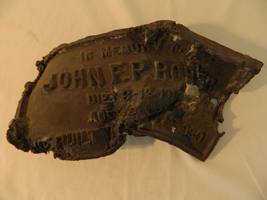
... Victorian High Country Huts Association Inc. members and friends helped rebuild the hut which is now used as an emergency shelter for visitors to the High Plains. The memorabilia is significant as the items belonged to the Roper family who were one of the original settlers of the Kiewa Valley and one of the original families who drove their cattle up to the Bogong High Plains. The burnt plaque and forks and the rebuilding of the huts (Duane's & Roper's) are significant as bush fires are a constant threat to the Bogong High Plains destroying large areas ...Roper's Hut was built in 1939 and was burnt down in 2003. It was rebuilt in 2008 and is situated on the Bogong High Plains on Duane Spur (where Duane's hut had been before it too was destroyed by (1939) bushfires, between Mt Nelse and Big River. The original hut was used as a shelter for cattlemen who grazed their cattle on the High Plains during summer. The Victorian High Country Huts Association Inc. members and friends helped rebuild the hut which is now used as an emergency shelter for visitors to the High Plains.The memorabilia is significant as the items belonged to the Roper family who were one of the original settlers of the Kiewa Valley and one of the original families who drove their cattle up to the Bogong High Plains. The burnt plaque and forks and the rebuilding of the huts (Duane's & Roper's) are significant as bush fires are a constant threat to the Bogong High Plains destroying large areas at a time.1. Bronze Plaque and 2 damaged forks from Roper's Hut which was destroyed by bush fires in 2003. 2. DVD & USB and hard copy photos of the rebuild of Roper's Hut in January 2008.The plaque had 'In Memory of / John F. P. Roper/ died 3-12-1977 / Aged 78 years / He built the original hut Feb. 1939'roper's hut, cattlemen, bogong high plains, bronze plaque, roper family, bush fires -
 Kiewa Valley Historical Society
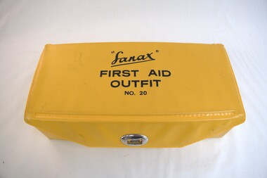
First Aid Kit, 1984
... Kiewa Valley Historical Society Mount Beauty Information Centre 31 Bogong High Plains Rd Mt Beauty high-country The State Electricity Commission of Victoria supplied First Aid Kits to its employees and 'ran' an ambulance during the construction of the Kiewa Hydro Electric Scheme (KHES). The KHES was constructed at the upper end of the Kiewa Valley in the Victorian mountains on the Bogong High Plains. This area ...The State Electricity Commission of Victoria supplied First Aid Kits to its employees and 'ran' an ambulance during the construction of the Kiewa Hydro Electric Scheme (KHES). The KHES was constructed at the upper end of the Kiewa Valley in the Victorian mountains on the Bogong High Plains. This area is remote with difficult terrain requiring people working and enjoying recreational activities to carry a first aid kit in case of emergency. This First Aid kit is light and portable enabling the user to 'fix' minor injuries and wait for access to medical assistance.This portable first aid kit was owned by a local Mt Beauty resident, Allan S. Clarke who was a long term staff employee for the State Electricity Commission of Victoria.First Aid Outfit (Kit), No.20 by "Sanax". Yellow plastic covered cardboard box with lid fastened by a metal swivel clasp. Complete with unused original contents displayed on two levels. On the top level - Absorbent lint in clear plastic bag; roll of Johnson's Cotton Wool in soft plastic; Plastic container of Sanax Aspirin tablets; glass bottle with brown plastic lid of Calamine Lotion; and steel scissors, safety pins and tweezers in small clear plastic bag. On the second/ bottom level - in a brown glass jar with brown plastic lid "Kuraburn for the treatment of Minor burns"; in a brown glass jar with brown plastic lid "Zeptic" (antiseptic); Johnson's Bandaids of varying shapes in a clear plastic bag; in a brown glass bottle with a brown plastic lid "Germistatic" (antiseptic); 2 packets of 4 Gauze bandages in clear plastic bags; and 1 large absorbent Gauze bandage in clear plastic bag.first aid kit; kiewa hydro electric scheme; sandax; medical aids; -
 Kiewa Valley Historical Society
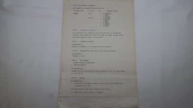
Papers - Falls Creek Tourist Area Management Committee, August 1984
... country Falls Creek is a ski resort in the north east of Victoria on the Bogong High Plains. Members of business's (accommodation & restaurants) formed the Falls Creek Chamber of Commerce to promote tourism 'under' the Falls Creek Tourist Area Management Committee. The Falls Creek Tourist Area Management Committee under the direction of the State Electric Commission of Victoria came into effect in 1959 and from then on building sites were leased and building and sewerage controls were applied. In 1979 the Victorian ...Falls Creek is a ski resort in the north east of Victoria on the Bogong High Plains. Members of business's (accommodation & restaurants) formed the Falls Creek Chamber of Commerce to promote tourism 'under' the Falls Creek Tourist Area Management Committee. The Falls Creek Tourist Area Management Committee under the direction of the State Electric Commission of Victoria came into effect in 1959 and from then on building sites were leased and building and sewerage controls were applied. In 1979 the Victorian State Government had established the Ski Industry of Victoria working party with a brief report on its operation. These papers give an insight into the business of the Falls Creek Chamber of Commerce in 1984 eg. car parking, noise, closure of the resort due to heavy snow falls, the media and general development of the resort. Local business people are named as attending the meeting indicating many non English surnames. 4 yellowed papers typed on both sides of the first 3 pages. irst paper has 6 items listed re Falls Creek Chamber of Commerce / Sub Committee on General Booking Conditions.Dated 15th August 1984 Next 3 papers dated 13th August 1984 Falls Creek Chamber of Commerce / Minutes of General Meetingfalls creek, ski resort, bogong high plains, falls creek chamber of commerce, snow, ski lodges, -
 Kiewa Valley Historical Society
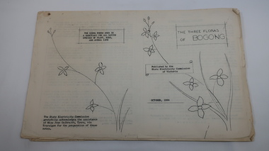
Mills Collection of Papers, 1. Unknown 2. October 1964. 3. Unknown SECV. 4. June 1963. 5. Unknown, Victorian Dept of Education. 6. Unknown SECV
... country Catelogue of flora and fauna of the 1960s in the Kiewa Region. Flora Bogong birds geology Kiewa valley tobacco forestry and conservation SECV No. 5. - Stamped with 'Hoys Passenger Service Pty Ltd' A collection of papers including: 1. Three poems. 2. The ''Three Floras of Bogong'Oct 1964. 3. 'SEC Bird Life within and adjacent to the Kiewa Works area' recorded between 1963 and 1964. 4. 'General Geology of the Kiewa Area' June 1963. 5. Victorian ...Catelogue of flora and fauna of the 1960s in the Kiewa Region.A collection of papers including: 1. Three poems. 2. The ''Three Floras of Bogong'Oct 1964. 3. 'SEC Bird Life within and adjacent to the Kiewa Works area' recorded between 1963 and 1964. 4. 'General Geology of the Kiewa Area' June 1963. 5. Victorian Department of Agriculture, 'Tobacco', Notes for Students/Geology/Maize Culture/The Buffalo Dam Project/Stamped with 'Hoys Passenger Service Pty Ltd'. 6, SEC Kiewa Region, Forestry and Conservation.No. 5. - Stamped with 'Hoys Passenger Service Pty Ltd'flora, bogong, birds, geology, kiewa valley, tobacco, forestry and conservation, secv -
 Kiewa Valley Historical Society
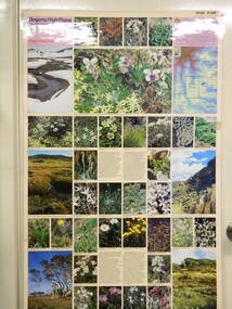
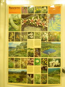
Map / Chart, Vegetation Map & Guide to Alpine Flora: Pretty Valley, 1982
... Kiewa Valley Historical Society Mount Beauty Information Centre 31 Bogong High Plains Rd Mt Beauty high-country This poster shows Pretty Valley is on the Victorian High Plains where the State Electricity Commission of Victoria worked on the Kiewa Hydro Scheme. Also cattle have grazed in the area ...This poster shows Pretty Valley is on the Victorian High Plains where the State Electricity Commission of Victoria worked on the Kiewa Hydro Scheme. Also cattle have grazed in the area over the years. This map is of interest to compare the flora in the area with times prior to 1982 and after 1982.This poster has historical and research value as it shows the flora in the pretty valley area therefore making it significant for people interested in plants. Also for those who would like to compare what plants are still in this area after 1982 and if the cattle grazing, climate change, of bush fires have had on the environment. Thus this poster also has good interpretive capacity of these reasons. Laminated double sided vegetation map and photographic guide to Alpine flora of the Pretty Valley areapretty valley. bogong. vegetation. plants. flowers. alpine. victorian high plains. cattle grazing. s.e.c.v. -
 Kiewa Valley Historical Society
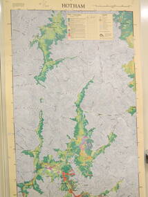
Map / Chart, Vegetation Map & Guide to Alpine Flora: Hotham, 1982
... Kiewa Valley Historical Society Mount Beauty Information Centre 31 Bogong High Plains Rd Mt Beauty high-country This poster shows Mt Hotham is on the Victorian High Plains. This poster and map enables the comparison to be made of flora in other areas of the Victorian High Plains e.g.. which was previously known as the Bogong High Plains. ...This poster shows Mt Hotham is on the Victorian High Plains. This poster and map enables the comparison to be made of flora in other areas of the Victorian High Plains e.g.. which was previously known as the Bogong High Plains. This poster has historical and research value as it shows the flora in Mt Hotham area therefore making it significant for people interested in plants. Also for those who would like to compare what plants are still in this area after 1982 and if the cattle grazing, climate change, of bush fires have had on the environment. Thus this poster also has good interpretive capacity of these reasons.Laminated double sided vegetation map and photographic guide to Alpine flora of the Hotham area.hotham. vegetation. plants. flowers. alpine. high plains of victoria. -
 Kiewa Valley Historical Society
Map / Chart, Vegetation Map & Guide to Alpine Flora: Rocky Valley, 1982
... Kiewa Valley Historical Society Mount Beauty Information Centre 31 Bogong High Plains Rd Mt Beauty high-country This poster is of Rocky Valley is on the Victorian High Plains where the State Electricity Commission of Victoria worked on the Kiewa Hydro Electric Scheme and also where cattlemen brought their cattle up during summer at various times. Its significance is due to it shows the flora of the area ...This poster is of Rocky Valley is on the Victorian High Plains where the State Electricity Commission of Victoria worked on the Kiewa Hydro Electric Scheme and also where cattlemen brought their cattle up during summer at various times. Its significance is due to it shows the flora of the area after the Kiewa Hydro Electric Scheme Rocky Valley damn has been build and therefore is a valuable for comparison to see what plants are there now after this information on this poster was complied. Historic: Comparison of the flora at Rocky Valley with other areas on the Victorian High Plains and with Rocky Valley before and after the Kiewa Hydro Scheme and / or grazing there. Is therefore research significance and interpretive capacity due to this compatibility value.Laminated double sided vegetation map and guide to the Alpine flora of the Rocky Valley area, with photographs of plants and vegetation.rocky valley. alpine. flora. vegetation. plants. s.e.c.v.. cattlemen. victorian high plains. -
 Kiewa Valley Historical Society
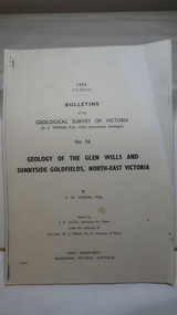
Document - Four Geological reports on the North-east Goldfields, Geological Survey of Victoria 1958 Bulletin
... country Geological Surveys of N.E. Goldfields Victoria included mines and tunnels. A resurvey of goldfields was necessary to re-assess economic possibilities using modern techniques and structural interpretation. It included an examination of a considerable surface area with maps and underground workings. Results were correlated and integrated and published by the Mines Department. The mines are in the Bogong Alpine Area. geology in the north-east gold fields goldmines glen wills Foolscap printed Victorian ...Geological Surveys of N.E. Goldfields Victoria included mines and tunnels. A resurvey of goldfields was necessary to re-assess economic possibilities using modern techniques and structural interpretation. It included an examination of a considerable surface area with maps and underground workings. Results were correlated and integrated and published by the Mines Department.The mines are in the Bogong Alpine Area.Foolscap printed Victorian Bulletins. Each stapled in the top left corner and each with varying number of pages. Covering 1941-1958 a) Glen Wills and Sunnyside b) Sunnyside Tunnel c) Red Robin d) Maud and Yellow Girl Government Printer, Mines Department, Melbourne, Victoriageology in the north-east, gold fields, goldmines, glen wills -
 Kiewa Valley Historical Society
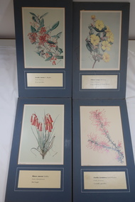
Illustrations of Wildflowers
... Kiewa Valley Historical Society Mount Beauty Information Centre 31 Bogong High Plains Rd Mt Beauty high-country The Bogong High Plains have many Alpine wild flowers unique to the area. The SECV appointed artists to draw the wild flowers in the Victorian Alps where they were constructing the Kiewa Hydro Electric Scheme. ...The Bogong High Plains have many Alpine wild flowers unique to the area.The SECV appointed artists to draw the wild flowers in the Victorian Alps where they were constructing the Kiewa Hydro Electric Scheme.32 illustrated wild flowers each mounted on blue/grey particle board with Botanical and Family name and common name printed underneathalpine wildflowers, alison m. ashby, flora illustrations -
 Kiewa Valley Historical Society
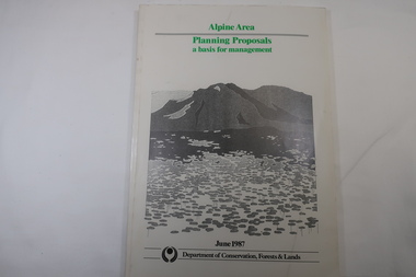
Book - Book - Alpine Area - Department of Conservation, Forests & Lands, Alpine Area / Planning Proposals / a basis for management. 1987
... areas. It is noted for its diverse plant and animal life, scenery, recreation opportunities and as a water catchment. This country is at the upper end of the Kiewa Valley and the planning for it is of interest to the Kiewa Valley inhabitants. Alpine Area Bogong National Park Victorian ...It is the policy of the Government that most of the State's alpine area will be proclaimed as an Alpine National Park, which would complement the Kosciusko National Park in N.S.W.. This is yet to be achieved (1987), however there is a need for sound, efficient and coordinated management based on the area's natural features, values and uses. Planning is proceeding on this basis.Victoria's alpine area is one of the State's most outstanding and spectacular natural areas. It is noted for its diverse plant and animal life, scenery, recreation opportunities and as a water catchment. This country is at the upper end of the Kiewa Valley and the planning for it is of interest to the Kiewa Valley inhabitants.White bound book with green print for title at the top, black & white picture and black print at the bottom for the name of the government authority publishing the book.143 pages with fold out map after page 7. The map is coloured green to indicate the planning area.alpine area, bogong national park, victorian department of conservation forests & lands -
 Bendigo Military Museum
Certificate - APPEALS 2004, Victorian State Branch RSL, 31.1.2005
... Bendigo Military Museum 37 - 39 Pall Mall Bendigo goldfields The Poppy Appeal is conducted every year leading up to Remembrance Day November 11th. brsl smirsl poppy appeal "Awarded to Bendigo RSL Sub - Branch - Top seller 2004 Poppy Appeal country area - 31st January 2005" Certificate, frame is timber brown/gold colour, certificate in colour white background with RSL Logo at the top, followed by "Returned & Service's League of Australia (Victorian Branch) Inc", under is the details of the award, signed and dated with red seal in RH corner. ...The Poppy Appeal is conducted every year leading up to Remembrance Day November 11th.Certificate, frame is timber brown/gold colour, certificate in colour white background with RSL Logo at the top, followed by "Returned & Service's League of Australia (Victorian Branch) Inc", under is the details of the award, signed and dated with red seal in RH corner."Awarded to Bendigo RSL Sub - Branch - Top seller 2004 Poppy Appeal country area - 31st January 2005"brsl, smirsl, poppy appeal -
 Bendigo Military Museum
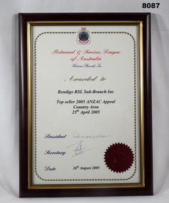
Certificate - APPEALS 2005, Victorian RSL State Branch, 26.8.2005
... Bendigo Military Museum 37 - 39 Pall Mall Bendigo goldfields The ANZAC Appeal is conducted every year leading up to ANZAC Day April 25th. brsl smirsl anzac appeal "Awarded to - Bendigo RSL Sub - Branch Inc - Top seller 2005 ANZAC Appeal country area 25th April 2005" Certificate, frame is timber brown/gold colours, certificate in colour white background with ornate edge, RSL Logo at the top followed by "Returned & Service's League of Australia (Victorian Branch) Inc, under is details of the award, signed and dated with red seal in RH corner. ...The ANZAC Appeal is conducted every year leading up to ANZAC Day April 25th.Certificate, frame is timber brown/gold colours, certificate in colour white background with ornate edge, RSL Logo at the top followed by "Returned & Service's League of Australia (Victorian Branch) Inc, under is details of the award, signed and dated with red seal in RH corner."Awarded to - Bendigo RSL Sub - Branch Inc - Top seller 2005 ANZAC Appeal country area 25th April 2005"brsl, smirsl, anzac appeal -
 Bendigo Military Museum
Certificate - APPEALS 2006, Victorian RSL State Branch, 11.11.2006
... Bendigo Military Museum 37 - 39 Pall Mall Bendigo goldfields The Poppy Appeal is conducted every year leading up to Remembrance Day November 11th. brsl smirsl poppy appeal "Awarded to - Bendigo RSL Sub - Branch Inc - Top seller 2006 Poppy Appeal country area - date 11th November 2006 Certificate, frame is timber brown/gold colour, certificate in colour white background ornate edge with RSL Logo at the top followed by "Returned and Service's League of Australia (Victorian Branch) Inc", signed and dated with red seal in RH Corner. ...The Poppy Appeal is conducted every year leading up to Remembrance Day November 11th.Certificate, frame is timber brown/gold colour, certificate in colour white background ornate edge with RSL Logo at the top followed by "Returned and Service's League of Australia (Victorian Branch) Inc", signed and dated with red seal in RH Corner."Awarded to - Bendigo RSL Sub - Branch Inc - Top seller 2006 Poppy Appeal country area - date 11th November 2006brsl, smirsl, poppy appeal -
 Bendigo Military Museum
Certificate - APPEALS 2007, Victorian RSL State Branch, 22.2.2008
... Bendigo Military Museum 37 - 39 Pall Mall Bendigo goldfields The Poppy Appeal is conducted every year in the lead up to Remembrance Day November 11th. brsl smirsl poppy appeal "Awarded to Bendigo RSL Sub - Branch - In recognition of your achievement in obtaining the highest sales for the 2007 Poppy Appeal in the country area - dated 27th February 2008" Certificate, frame is timber brown colour, certifcate colour with ornate edge with RSL Logo at the top followed by "Returned & Service's League of Australia (Victorian Branch) Inc", under is details of the award, signed and dated, red seal in RH corner. ...The Poppy Appeal is conducted every year in the lead up to Remembrance Day November 11th.Certificate, frame is timber brown colour, certifcate colour with ornate edge with RSL Logo at the top followed by "Returned & Service's League of Australia (Victorian Branch) Inc", under is details of the award, signed and dated, red seal in RH corner."Awarded to Bendigo RSL Sub - Branch - In recognition of your achievement in obtaining the highest sales for the 2007 Poppy Appeal in the country area - dated 27th February 2008"brsl, smirsl, poppy appeal -
 Bendigo Military Museum
Certificate - APPEALS 2008, Victorian RSL State Branch, 11.11.2008
... Bendigo Military Museum 37 - 39 Pall Mall Bendigo goldfields The Poppy Appeal is conducted every year in the lead up to Remembrance Day 11th November. brsl smirsl poppy appeal "Awarded to Bendigo RSL Sub Branch - In recognition of your achievement in being top seller for the 2008 Poppy Appeal in the country area - dated 11th November 2008" Certificate, frame is timber brown colour, certificate colour with ornate edge RSL Logo at the top followed by "Returned & Service's League of Australia (Victorian Branch) Inc", under is details of the award, signed, dated and red seal in RH corner. ...The Poppy Appeal is conducted every year in the lead up to Remembrance Day 11th November.Certificate, frame is timber brown colour, certificate colour with ornate edge RSL Logo at the top followed by "Returned & Service's League of Australia (Victorian Branch) Inc", under is details of the award, signed, dated and red seal in RH corner."Awarded to Bendigo RSL Sub Branch - In recognition of your achievement in being top seller for the 2008 Poppy Appeal in the country area - dated 11th November 2008"brsl, smirsl, poppy appeal -
 Bendigo Military Museum
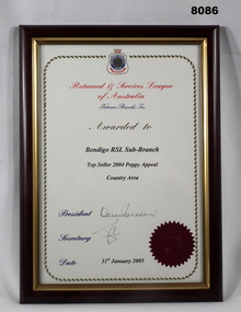
Certificate - APPEALS 2003, Victorian RSL State Branch, 31.1.2004
... This Appeal and the following 5 Appeals through to 2008 were all conducted from the Soldiers Memorial Institute in the old kitchen which was demolished as part of the Restorations during 2016 - 18. brsl smirsl poppy appeal "Awarded to Bendigo RSL - Sub Branch - Top seller 2003 Poppy Appeal Country area - 31st January 2004" Certificate, frame is timber black colour, certificate in colour has white background with ornate edge with RSL Logo at the top followed by "Returned & Service's League of Australia (Victorian Branch) Inc".Under is the detail of the award, signed and dated with Red Seal in RH Corner. ...The Poppy Appeal is conducted yearly leading up to Remembrance Day November 11th. This Appeal and the following 5 Appeals through to 2008 were all conducted from the Soldiers Memorial Institute in the old kitchen which was demolished as part of the Restorations during 2016 - 18.Certificate, frame is timber black colour, certificate in colour has white background with ornate edge with RSL Logo at the top followed by "Returned & Service's League of Australia (Victorian Branch) Inc".Under is the detail of the award, signed and dated with Red Seal in RH Corner."Awarded to Bendigo RSL - Sub Branch - Top seller 2003 Poppy Appeal Country area - 31st January 2004"brsl, smirsl, poppy appeal -
 Kiewa Valley Historical Society
Poster Brochure, Mt Beauty Tawonga Heart Of Victoria's High Country, Circa 1995
... Kiewa Valley Historical Society Mount Beauty Information Centre 31 Bogong High Plains Rd Mt Beauty high-country The Item is a pictorial time piece of the valley and usage, farms,industry,town area, vegetation and winter snow levels Historical and the social-economical development at circa 1995 of land usage and residential buildings style.Major social events e.g. Festival of the Bogong Moth and the Mt Beauty Mardi Gras. It is also a good historical record of tourism campaigns of the Alpine Shire and Mt Beauty Chamber of Commerce. Also see "KVHS 0125" tourism mt beauty tawonga photographs victorian ...The Item is a pictorial time piece of the valley and usage, farms,industry,town area, vegetation and winter snow levels Historical and the social-economical development at circa 1995 of land usage and residential buildings style.Major social events e.g. Festival of the Bogong Moth and the Mt Beauty Mardi Gras. It is also a good historical record of tourism campaigns of the Alpine Shire and Mt Beauty Chamber of Commerce. Also see "KVHS 0125"Brochure folds out from a 20.5cm x 29.5cm to 82cm x 29.5cm poster type documentinside panoramic photo of snow tipped alpine mountain range incorporating the Mount Beauty township, farming area of the Kiewa Valley and relevant tourist orientated informationtourism mt beauty tawonga photographs, victorian alps -
 Kiewa Valley Historical Society
Mug Stoneware
... country (Victorian Alps) but was instrumental in establishing two Chalets. One of these Chalets was the first one to be built on the Bogong High Plains. This item, "Bill Bogong's Mug" is what the Flinders Petrie(famous English Egyptologist/Archaelogist) Rover Crew(formed in 1940) presented newly invested members of the exclusive(200 membership) Alpine Rover Crew. The Melbourne Walking Club has a long history with the Victorian High Plains area ...This ceramic mug is titled "Bill Bogong's Mug" in honour of one of Australia's Scouting (Rovers) notable office holders, Mr.W.F."Bill" Waters. He was born on 22nd August 1897 in Taralgon, Victoria, Australia and died 8th October 1968 in Fitzroy, Victoria. He was instrumental in the Rovers building two chalets in the Victorian Alps. The Victorian Award of the National Rover Service Award(1980) has been named after Bill Waters. Bill Waters was also the leader of the first team that climbed Mount Bogong in winter in 1929. Also was part of rescue team of what is now know as the Cleve Cole tragedy on Mt Bogong in the mid 1930's. There is also a water fall named after him Waters Falls on the Bogong High Plains. W.F."Bill" Waters aka "Bill Bogong" (Bogong mountain, were his ashes were scattered), was not only a prominent bush walker (Melbourne Walking Club) of the high country (Victorian Alps) but was instrumental in establishing two Chalets. One of these Chalets was the first one to be built on the Bogong High Plains. This item, "Bill Bogong's Mug" is what the Flinders Petrie(famous English Egyptologist/Archaelogist) Rover Crew(formed in 1940) presented newly invested members of the exclusive(200 membership) Alpine Rover Crew. The Melbourne Walking Club has a long history with the Victorian High Plains area, of which the Kiewa Valley is an integral part of the Victorian Alpine Region. Due to the connections Bill Waters has with the Bogong High Plains and Mt Bogong this cup has a lot of significance to the social history of the area.. Round glazed stoneware mug, white in colour, with a heritage green coloured band covering the top rim and handle. Written inscription on the front "Bill Bogong's Mug" in large print and beneath it, in smaller print, "with compliments from Flinders Petrie Rover Crew" The other side of the mug is a free hand landscaped drawing of green bush and blue hills with a tree supporting a tent and a camp fire (with smoke rising from it).To the left of the inscription is the Scout (Rover) emblem coloured black with an unraveled and unwritten signage scroll fowler ceramics, local alpine history, alpine rovers, scouts, mugs, mt bogong, bogong high plains -
 Kiewa Valley Historical Society
Photograph Farm Land, Mount Beauty Acreage before Golf Course, Circa 1950
... country This photograph is a "snap shot" in time circa 1950s detailing the rural environment before the effects of the Kiewa Valley Hydro Scheme altered the basic rural setting of the valley. The golfing fairway was being mapped out on previous grazing land, before the laying of a golf course, for use by the construction workers and auxiliary administration employees of the Victorian State Electricity Commission. This photograph details a dramatic period in time which saw an enormous change to the exclusively rural area ...This photograph is a "snap shot" in time circa 1950s detailing the rural environment before the effects of the Kiewa Valley Hydro Scheme altered the basic rural setting of the valley. The golfing fairway was being mapped out on previous grazing land, before the laying of a golf course, for use by the construction workers and auxiliary administration employees of the Victorian State Electricity Commission. This photograph details a dramatic period in time which saw an enormous change to the exclusively rural area of the Kiewa Valley region in the mid 1900s. This change presented both physical and mental challenges to the existing quiet rural inhabitants of the valley. The State of Victoria had to make adjustments to the changing demands imposed by population and industrial expansions. The development of cleaner energy supplies to a growing population has its downside ,which ever way the intrusion into the "natural" landscape is made.Black and white photograph detailing surveyor posts for construction of golf course. Land used, before establishment of the Mount Beauty Village, as farming/grazing cattle and viewed towards Mount Bogong and its Alpine ranges. The photo is on 200gms paper and not on photographic paper.nilmount beauty in the 1940s - 1950s, grazing in the kiewa valley, sec victoria -
 Kiewa Valley Historical Society
Photograph of Snow Covered Catchment Area Vic, Snow Covered Catchment Area Victorian Alps - 1950s, Circa 1950
... Kiewa Valley Historical Society Mount Beauty Information Centre 31 Bogong High Plains Rd Mt Beauty high-country This photograph details (early to mid1950s), the Victorian Alpine region when this remote area was part of a "lay back" rural landscape,occasionally visited by recreational adventurers and some wayward tourists. ...This photograph details (early to mid1950s), the Victorian Alpine region when this remote area was part of a "lay back" rural landscape,occasionally visited by recreational adventurers and some wayward tourists. The mountain ranges had provided an adequate barrier against the way-would traveller, but with the opening up of this region by the provision of improved roadways and accommodation facilities, courtesy of the Kiewa Valley Hydro Electricity Scheme, changes such as tourism and its impact upon the "natural" state started to show its side effects (clearing of the land). The expansion of the European immigration numbers (1950s) coming into Australia was increasing after World War II which not only provided increased construction workers to the region but also immigrants who appreciated alpine regions. Some of these immigrants contributed to the expansion of the region and provided for a greater degree of diverse professions and rural related work force.This photograph depicts the borderline in time between an exclusively rural based population and respective activities(early 1900s)to the present (2000 on wards) integrated village, tourist and retiree/holiday area. The time when land was exclusively used in agriculture and Alpine grazing lands is over. The Kiewa Valley is loosing its hiding place and is becoming more and more a source of untapped residential land and winter time recreational adventure lands. The changes brought about by modern technologies involving recreational activities such as hang gliding, gliding (local airstrip), mountain bikes, car rallies and their associated clubs is providing for an increased short term population boost. These together with the attractions for retirees is changing not only the physical nature of the Kiewa valley but also its "soul".This item is a black and white photograph of a section of snow covered catchment area in the Victorian Alps in the mid 1900. It is on 200 gms paper but not on photographic paper and has a white boarder (3 mm).kiewa valley tourism, victorian alps, alternate energy supplies, alpine population growth