Showing 75 items matching "victorian railways plans"
-
 Tatura Irrigation & Wartime Camps Museum
Map - plan, Engineer for Contruction Railways Dept, Toolamba and Tatura Railway, 18 August 1879
... Victorian Railways plans...Tatura Irrigation & Wartime Camps Museum 49 Hogan Street Tatura the-murray Original plan Victorian Railways plans Victorian Railways. signed by Engineer in ink. 2 sheets stapled together, white paper. ...Original plan2 sheets stapled together, white paper. Plan of proposed railway line drawn in ink. Names of property owners transverse shown. Roads show. Existing buildings, dams (tanks), wells and railway culverts.Victorian Railways. signed by Engineer in ink.victorian railways plans -
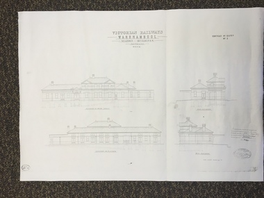 Warrnambool and District Historical Society Inc.
Map, Victorian Railway W'bool No1 & No2, 1897
... These two sheets show the 1897 plans drawn up by the Victorian Railways for the erection of the Warrnambool Railway Station building. ...railway stations and many of similar design were erected in the 1880s and 90s. These plans are important because they show clearly the design of the Warrnambool Railway Station buildings when they were first erected in the 1890s.They will be very useful for researchers. The coming of the railway was a significant event in Warrnambool’s history and did much to make the port and shipping a less viable proposition. warrnambool railway station buildings ‘Victorian Railways, Warrnambool, Station Buildings, Scale 8 feet to one inch, Contract No. 6379B (Nos. 1 and 2)’ These are two architect’s plans and drawings of the Warrnambool Railway Station building (1897). ...These two sheets show the 1897 plans drawn up by the Victorian Railways for the erection of the Warrnambool Railway Station building. It is a two-storey building still existing today. The railway came to Warrnambool in 1890 and they must have used temporary buildings for seven years before this railway building was erected. It had offices, booking counter and public facilities on the ground floor and housing for the Station Master on the first floor. The building erected was a typical design for country town railway stations and many of similar design were erected in the 1880s and 90s. These plans are important because they show clearly the design of the Warrnambool Railway Station buildings when they were first erected in the 1890s.They will be very useful for researchers. The coming of the railway was a significant event in Warrnambool’s history and did much to make the port and shipping a less viable proposition.These are two architect’s plans and drawings of the Warrnambool Railway Station building (1897). The drawings are black and white and the first plan shows the ground floor plan and the first floor plan and the outbuildings. The second plan shows drawings of the building with its elevation to the platform and its elevation to Merri Street. There are two stamps of the Railways Department, Melbourne. These are copies, not originals. ‘Victorian Railways, Warrnambool, Station Buildings, Scale 8 feet to one inch, Contract No. 6379B (Nos. 1 and 2)’warrnambool, railway station buildings -
Federation University Historical Collection
Report, A Tourism Market & Product Development Plan for the City of Ballarat, 1995, 22/11/2019
... Barker Library (top floor) Mount Helen goldfields victorian tourism industry alumni tourism ballarat railway precinct jill dunn michael pearlman murray j. millard ian parker david kima eureka stockade black hill lookout lake wendouree camp street precinct tramway White report by three University of Ballarat Students in Tourism. A Tourism Market & Product Development Plan ...White report by three University of Ballarat Students in Tourism. victorian tourism industry, alumni, tourism, ballarat railway precinct, jill dunn, michael pearlman, murray j. millard, ian parker, david kima, eureka stockade, black hill lookout, lake wendouree, camp street precinct, tramway -
 Federation University Historical Collection
Booklet - Annual Report, Greater Ballarat Association Annual Report 1952-1974, 1952-1974
... Cooke. greater ballarat association annual report edgar bartrop g.b. richmond a.w. nicholson g.e. deeble r.g> caddell l.j. fraser t.u. haymes a.w. lynch keith rash tourist bureau botanical gardens telepone booth pryor park tree planting ballarat zoological gardens centenary window dressing competition soldier settlement proposal for university for ballarat caravan park ballarat common ballarat common development t.t. hollway housing commission wendouree housing commission industrial development s.s. ballarat begomia festiva r.g. caddell w.gordon smith f.h. menzies olympic rowing royal tour decorations begonia float widening of railway bridge j. chatham l.g. chester s.v. playsted n. ellis langi kal kal langi kal kal training centre migrants to victoria flood lighting of the arch of victory olympics holidays ballarat's projected olympic pool ballarat fish hatcheries olympic hostel town planning murray byrne titles for residence areas service club signs railway level crossing traffic ploughing competition w. fraser young australia league removal of raaf from ballarat renumbering of streets renumbering of streets to the block system miners' racecourse reserve historical museum ballarat historical society c.m. canty mavis canty university status ballarat university college j.w. murray p.r. gray b.c. mcorist n.c. ellis w.h. heinz save the lake campaign lake wendouree weed home host scheme b. walker develop victoria council eureka development victorian decentralization league r.h. ramsay allan c. pittard w. gordon smith c.h. davis b.c. hedgcock les kennedy p.j. rice a.f. waddington john p. cook historic markers maze traffic lights bungal dam camera clubs sunraysia way map centre of road parking paddle steamer wendouree apex local government women's association may nelson wes sobey melton foo l.l. zilles dulcie sullivan m. barnes lou zilles john wesley sobey e.r. ingles herb warren kryal castle Eighteen annual reports of the Greater Ballarat Association. ...The first presedent of the Greater Ballarat Association in 1938 was Robert J. Cooke. Eighteen annual reports of the Greater Ballarat Association. Each one discussed the work of the association and lists the subscribers. greater ballarat association, annual report, edgar bartrop, g.b. richmond, a.w. nicholson, g.e. deeble, r.g> caddell, l.j. fraser, t.u. haymes, a.w. lynch, keith rash, tourist bureau, botanical gardens telepone booth, pryor park tree planting, ballarat zoological gardens, centenary window dressing competition, soldier settlement, proposal for university for ballarat, caravan park, ballarat common, ballarat common development, t.t. hollway, housing commission, wendouree housing commission, industrial development, s.s. ballarat, begomia festiva, r.g. caddell, w.gordon smith, f.h. menzies, olympic rowing, royal tour decorations, begonia float, widening of railway bridge, j. chatham, l.g. chester, s.v. playsted, n. ellis, langi kal kal, langi kal kal training centre, migrants to victoria, flood lighting of the arch of victory, olympics holidays, ballarat's projected olympic pool, ballarat fish hatcheries, olympic hostel, town planning, murray byrne, titles for residence areas, service club signs, railway level crossing, traffic, ploughing competition, w. fraser, young australia league, removal of raaf from ballarat, renumbering of streets, renumbering of streets to the block system, miners' racecourse reserve, historical museum, ballarat historical society, c.m. canty, mavis canty, university status, ballarat university college, j.w. murray, p.r. gray, b.c. mcorist, n.c. ellis, w.h. heinz, save the lake campaign, lake wendouree, weed, home host scheme, b. walker, develop victoria council, eureka development, victorian decentralization league, r.h. ramsay, allan c. pittard, w. gordon smith, c.h. davis, b.c. hedgcock, les kennedy, p.j. rice, a.f. waddington, john p. cook, historic markers, maze, traffic lights, bungal dam, camera clubs, sunraysia way, map, centre of road parking, paddle steamer, wendouree apex, local government women's association, may nelson, wes sobey, melton foo, l.l. zilles, dulcie sullivan, m. barnes, lou zilles, john wesley sobey, e.r. ingles, herb warren, kryal castle -
 Eltham District Historical Society Inc
Document - Survey Plan, Country Roads Board, SP 6313, Eltham-Yarra Glen Road; Luck St to Henry St, 1956
... Plan 1956 A.L. Lyon A.W. Brinkkotter Arthur Street C.R. Burkett Dudley Street E.N. Staff eltham war memorial trust henry street Luck Street Pryor Street The Board of Land & Works The Equity Trustees Executors and Agency Coy Ltd The Roman Catholic Trusts Corporation Victorian Railways Commision Neil Webster Collection A3 print, 2 pages and electronic PDF file SP 6313, Eltham-Yarra Glen Road; Luck St to Henry St Document Survey Plan Country Roads Board ...1956 C.R.B. Plan of Survey of Part of Crown Portion 13 Section 4 Parish of Nillumbik, County of Evelyn Eltham-Yarra Glen Road, Shire of Eltham Shows Surveyor field notes, property ownership and building type and construction.eltham-yarra glen road, country roads board, eltham, main road, survey plan, 1956, a.l. lyon, a.w. brinkkotter, arthur street, c.r. burkett, dudley street, e.n. staff, eltham war memorial trust, henry street, luck street, pryor street, the board of land & works, the equity trustees executors and agency coy ltd, the roman catholic trusts corporation, victorian railways commision, neil webster collection -
Glen Eira Historical Society
Article - ORMOND RAILWAY STATION
... This file contains two items: 1/ Six letters of correspondence to and from Victorian Railways regarding the decision to change the name of North Road Railway Station to South Caulfield and ultimately Ormond Station. The letters date from March 1891 til August 1897. 2/ An article from the Glen Eira/Port Phillip Leader dated 12/04/2013 regarding planning and construction works being undertaken to grade-separate the North Road level crossing....Glen Eira Historical Society 965 Glen Huntly Rd Caulfield VIC 3162 melbourne This file contains two items: 1/ Six letters of correspondence to and from Victorian Railways regarding the decision to change the name of North Road Railway Station to South Caulfield and ultimately Ormond Station. The letters date from March 1891 til August 1897. 2/ An article from the Glen Eira/Port Phillip Leader dated 12/04/2013 regarding planning and construction works being undertaken to grade-separate the North Road level crossing. ...This file contains two items: 1/ Six letters of correspondence to and from Victorian Railways regarding the decision to change the name of North Road Railway Station to South Caulfield and ultimately Ormond Station. The letters date from March 1891 til August 1897. 2/ An article from the Glen Eira/Port Phillip Leader dated 12/04/2013 regarding planning and construction works being undertaken to grade-separate the North Road level crossing.north road, caulfield south, south caulfield, north road railway station, ormond, oakley e., warrein, pritchard t. h., caulfield, caulfield shire council, glen huntly station, glenhuntly station, hyams jamie, railway stations, railways, mayors, stations, public transport, railway crossings, correspondence, local officials and employees, local government, engineering, railways construction, glen eira/port phillip leader -
Glen Eira Historical Society
Article - VICTORIAN RAILWAYS
... plans to operate a railway. 3/Original newspaper article (and image) from ‘Moorabbin Standard’ dated 25/11/1981, titled ‘Centenary train to carry mayors’. Article reports that a special train will run from Spencer Street Station to Mordialloc railway Station on Saturday 19/12/1981 to celebrate the centenary of the railway line to Mordialloc. Story mentions that in 1881, the Caulfield to Mordialloc line was a single track and that passengers can also board the special train at Caulfield Station. Image is of steam train with red ‘tait’ carriages (undated). Victorian ...File contains 3 items: 1/Original handwritten notes by Leo J Harrington (VR Melbourne) and T O’Callaghan titled ‘Victorian Railways to ‘62’. Notes include dates of electrification of lines, station openings, valuations, railway station names and their origins. Reference to council minutes regarding request to change the name of Elsternwick station to Caulfield in June 1871. 2/Original newspaper article from ‘The Age’ dated 10/06/1978 by Graeme Davidson titled ‘A case study of Railway politics’. Article refers to a publication called ‘Return to Rosstown, Railway, Land Sales and Sugar Beet ventures in Caulfield’ by D. F. ‘Return to Rosstown’ recounts the story of the Rosstown Junction railway and its creator, William Murray Ross. Tells of Ross’ life since coming to Australia from Liverpool and how he prospered as a land speculator owning large tracts of land in Caulfield, the sugar mill and his plans to operate a railway. 3/Original newspaper article (and image) from ‘Moorabbin Standard’ dated 25/11/1981, titled ‘Centenary train to carry mayors’. Article reports that a special train will run from Spencer Street Station to Mordialloc railway Station on Saturday 19/12/1981 to celebrate the centenary of the railway line to Mordialloc. Story mentions that in 1881, the Caulfield to Mordialloc line was a single track and that passengers can also board the special train at Caulfield Station. Image is of steam train with red ‘tait’ carriages (undated).victorian railways, caulfield, glenhuntly, glen huntly, elsternwick, carnegie, murrumbeena, ormond, steam train, glenhuntly road, glen huntly road, ripponlea, north road, rosstown, rosstown junction railway, ross william murray, railways, trains, south caulfield, grange road, railway stations, mirrambeena, caulfield city council, sugar mill, electrification. -
Glen Eira Historical Society
Document - Historic Conservation Areas Project
... Caulfield Library Dandenong Road Nepean Highway Hotham Street Iknerman Road Orrong Road North Road Poath Road ‘Plan of the City of Caulfield’ North Ward East Ward South Ward West Ward Kooyong Road Neerim Road Bambra Road Balaclava Road Shire of Caulfield Railways World War 1914-1918 Depression 1929-1939 Rippon Lea Labassa Parks Mansions Community Services ‘Caulfield North Draft Heritage Guidelines July 1999’ City of Glen Eira Caulfield North Heritage Area Glen Eira Heritage Management Plan Mayfield Grove Normanby Avenue Carnarvon Street Glenferrie Street Arthur Street Malakoff Street Normanby Road Heritage Advisory Service Construction Materials Victorian Style Mediterranean Style Spanish Mission Style Californian Bungalow Style Federation Style Architectural Style Architectural Features Heritage Conservation Design Building Construction Building Regulations Aboriginal Peoples Carnarvon Road Document Historic Conservation Areas Project ...Contains 4 items relating to historic conservation: 1/Five newsletters (one page each newsletter, dated 07/1975, 08/1975, 09/1975, 10/1975 and the final one 12/1975) describing how the project evolved, project funds, progress, study method, project 1 report, project 2 report and summary as no further funds available. Project was to include all of Melbourne but funding did not allow this. Note: newsletters stamped with Caulfield Historical Society. 2/Letter (one page on official city of Caulfield letterhead) from Andrew Rodda (manager planning) to Hazal Ford (dated 13/11/1989) describing ‘council resolved on 18/07/1989 to proceed with preliminary conservation survey’ and mentions that a copy is included. 3/Preliminary conservation survey for the City of Caulfield (nine pages) describing background, study area, budget, purpose, study outline, timeframe, report format, ownership, tasks and background information (mentions number and types of houses and properties as at 1986 and 1988) and a map of City of Caulfield. 4/Booklet (28 pages) titled ‘Heritage Area – Caulfield North Draft Heritage Guidelines July 1999 – City of Glen Eira’, containing Caulfield North Heritage Area, cultural heritage, Heritage Overlay Area, architectural description, common architectural forms and features, development guidelines, key design checklist. It includes a map of the Caulfield North Heritage Overlay Area, two illustrations about the development envelope and many black-and-white photographs of houses and architectural features.historic conservation areas project niven barbara, newsletters, town planning, historic buildings, heritage studies, housing, royal historical society of victoria (rhsv), read michael, plans, local government, historical societies, committee for urban action (cua), national trust, hopkins sherry ms., ford hazel, preliminary conservation survey, town planning, heritage studies, rodda andrew, city of caulfield, housing estates, victoria national estate grants program, australia icomos, burra charter, buildings structures and establishments, land surveys, suburbs, historic buildings, architectural significance, ‘caulfield’s heritage study’, soloman geulah dr., caulfield library, dandenong road, nepean highway, hotham street, iknerman road, orrong road, north road, poath road, ‘plan of the city of caulfield’, north ward, east ward, south ward, west ward, kooyong road, neerim road, bambra road, balaclava road, shire of caulfield, railways, world war 1914-1918, depression 1929-1939, rippon lea, labassa, parks, mansions, community services, ‘caulfield north draft heritage guidelines july 1999’, city of glen eira, caulfield north heritage area, glen eira heritage management plan, mayfield grove, normanby avenue, carnarvon street, glenferrie street, arthur street, malakoff street, normanby road, heritage advisory service, construction materials, victorian style, mediterranean style, spanish mission style, californian bungalow style, federation style, architectural style, architectural features, heritage conservation design, building construction, building regulations, aboriginal peoples, carnarvon road -
Glen Eira Historical Society
Document - History of the City of Caulfield
... Victorian Amateur Turf Club... Caulfield Cup... Glenhuntly Road... North Road... Glenhuntly Station... Ormond Station... Outer Circle Railway... Local Government... Gardenvale... Carnegie... Rosstown... Poath Road... Nepean Highway... Hotham Street... Ormond Park... Princes Park... Ross William Murray... Caulfield Institute of Technology... ‘Ross’ Folly’... Hawthorn Road... Glenhuntly... Ormond... Morris T. W.... Lloyd Charles Du Plan...Mary’s Church Caulfield Council Kooyong Road Neerim Road Bambra Road Greenmeadows House Caulfield Park Paddy’s Swamp Dandenong Road Caulfield Grammar School Chisholm Institute of Technology Murrumbeena Glen Eira Road Alma Road Orrong Road Balaclava Road Inkerman Road ‘Grosmont’ Caulfield School Room Caulfield Road Board Caulfield Road District Crimean War Victorian Amateur Turf Club Caulfield Cup Glenhuntly Road North Road Glenhuntly Station Ormond Station Outer Circle Railway Local Government Gardenvale Carnegie Rosstown Poath Road Nepean Highway Hotham Street Ormond Park Princes Park Ross William Murray Caulfield Institute of Technology ‘Ross’ Folly’ Hawthorn Road Glenhuntly Ormond Morris T. W. Lloyd Charles Du Plan ...This file contains 4 items: 1/Typewritten document titled ‘The City of Caulfield’. Author and date unknown. 1 page (back and front), 2 copies. Document covers topics such as origins of the name ‘Caulfield’, early settlement and the Caulfield Cup. 2/Typewritten document titled ‘History of Caulfield Council’. Author and date unknown. 6 pages, 3 copies. Document covers subjects such as early settlement, Aboriginal influence, Caulfield Road Board, Shire of Caulfield, Borough and town boundaries, coat of arms, and Freedom of Entry to the City. 3/Typewritten document (undated + author unknown) titled ‘The Structure of Local Government in Victoria with a history of the City of Caulfield’. 13 pages. Covers the following subjects: Powers, Planning, Public Works, Trading Undertakings, Health Services, Municipalities, Wards Electors or Ratepayers, Voters Roll, Councillors, Officers, Finance, Nature of Soil and Vegetation, Parks and Gardens and Reserves, Coat of Arms, Boundaries, How Did Caulfield get its Name, Aboriginal Influence, Caulfield Road Board, Shire of Caulfield, Borough and Town and the City of Caulfield. Also covered is early settlement. Note at the end of the document mentions that the historical content contained in the last section was based upon a thesis for the Department of Town and Regional Planning, University of Melbourne, 1968 by L. Alwis, P. Rowe, N. Wootten. Melbourne, ‘City of Caulfield: An Illustrated City Report’. 4/Typewritten document (undated) titled ‘The Structure of Local Government in Victoria with notes on the history of the City of Caulfield’. 8 pages, 2 copies. This document also includes a map/diagram of the city with boundaries and wards showing locations of railway stations and parks. Document covers the structure of local government and its functions then goes on to focus on City of Caulfield with subjects similar to those covered in item 3. Document signed off by Deputy Town Clerk.city of caulfield, caulfield john, caulfield baron, caulfield racecourse, elsternwick, ripponlea, st. mary’s church, caulfield council, kooyong road, neerim road, bambra road, greenmeadows house, caulfield park, paddy’s swamp, dandenong road, caulfield grammar school, chisholm institute of technology, murrumbeena, glen eira road, alma road, orrong road, balaclava road, inkerman road, ‘grosmont’, caulfield school room, caulfield road board, caulfield road district, crimean war, victorian amateur turf club, caulfield cup, glenhuntly road, north road, glenhuntly station, ormond station, outer circle railway, local government, gardenvale, carnegie, rosstown, poath road, nepean highway, hotham street, ormond park, princes park, ross william murray, caulfield institute of technology, ‘ross’ folly’, hawthorn road, glenhuntly, ormond, morris t. w., lloyd charles du plan, meals on wheels, shire of caulfield, caulfield railway station, caulfield rsl, bouran road, murrum murrumbeen, kooyong road, great dandenong road, neerim road, trams, prahran and malvern tramways trust, fisher andrew, mackinnon reserve, dover street, ‘glen eira’, blair max cr., insignia, third ordnance services unit, schools, street lighting, lampriere, mr. bevan, the caulfield leader, davies j. henry, curraweena road, st. georges road, o’neill college, hope george, market gardens, koornang reserve, packer reserve, murrumbeena reserve, hopetoun gardens, greenmeadows gardens, mirambeena, caulfield technical college, hart john, langdon h. j., ‘rosecraddock’, judge webb, ‘crotonhurst’, service james, ‘kilwinning’, ricketson henry, grimwade frederick sheppard, airdrie, jenner, st. aubin’s, caulfield john p. t., harlston, lempriere, lord reserve, ‘cantala’ -
 Eltham District Historical Society Inc
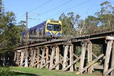
Photograph - Digital Photograph, Alan King, Eltham Railway Trestle Bridge, 28 December 2007
... But the Victorian Railways decided not to complete the formerly planned Diamond Valley Railway to Queenstown (now St Andrews) and Kinglake....But the Victorian Railways decided not to complete the formerly planned Diamond Valley Railway to Queenstown (now St Andrews) and Kinglake. ...Covered under National Trust of Australia (Victoria) State Significance and Heritage Overlay, Nillumbik Planning Scheme. Published: Nillumbik Now and Then / Marguerite Marshall 2008; photographs Alan King with Marguerite Marshall.; p103 The Eltham railway trestle bridge is the only one of its kind still regularly used in Melbourne’s metropolitan railway network. Opened in 1902, it is also one of Victoria’s very few timber rail bridges that still carries trains.1 The bridge is part of the railway line extension from Heidelberg - extended to Hurstbridge in 1912. This extension resulted in one of the greatest social changes experienced in Eltham Shire, as it considerably lessened its isolation attracting tourists, artists and suburban commuters particularly after World War Two.2 The bridge has been classified by the National Trust as historically, scientifically, aesthetically and socially significant at state level. But this has not always been recognised, and in 1977, locals fought to save it from destruction. The Victorian Railways proposed to replace the bridge with an earth embankment and large culverts to avoid maintenance problems and fire. This was rejected by the Eltham Council who protested that the bridge helped maintain the area’s rural character, historic link and beauty, as well as avoiding possible serious flooding on the flood plain if a culvert was blocked. The bridge stands as part of a National Trust classified landscape which includes the Alistair Knox Park, named after the local conservationist and architect who helped to make Eltham famous for its mud-brick houses. The landscape includes tall and spreading manna gums and candlebarks, and the historic Shillinglaw Cottage. Artist Walter Withers, one of the Heidelberg School of painters, painted the bridge early in the 20th century. The 38 span single-track railway bridge over creek and road has 34 timber-beam spans and four steel-joist spans, supported by four-pile timber piers and timber abutments. It has almost 200m of timber deck. All of the timbers have been replaced over the years, but the only change to the bridge’s character was the addition of pylons and wiring for electric trains in 1923. A petition for a railway to the shire was first made in 1883. A large deputation of local citizens to the Commissioner of Railways proposed a route passing through Alphington to midway between Greensborough and Eltham up the Diamond Creek valley towards Queenstown and Kinglake. As a result the Princes Bridge-Heidelberg Railway was opened in 1888. From 1888 locals demanded a railway extension. Kangaroo Ground farmers in particular, led by Shire Councillor and Member for Evelyn, Ewen Cameron, said it would assist local farmers and orchardists send their produce to the Melbourne market. In 1890, before the severe economic Depression, an extension of the line to Hurst’s Bridge (now Hurstbridge) was included in a new Railways Bill. The parliamentary delegations were regaled with a banquet at Hurst’s barn and entertained by the Diamond Creek Brass Band, but the extension was abandoned when the Depression struck in 1892-1893. The extension of the railway to Eltham, completed in 1902, was one of the few built in those hard times. That is why the Eltham timber-trestle railway bridge is a rare example of a broad-gauge rail bridge constructed between 1893 and 1910. At the opening, despite persistent drizzle, 300 children waving flags and banners were among the large crowd welcoming the first train, carrying official dignitaries, to Eltham. It had taken 24 years to bring the railway to Eltham. From then Eltham became a popular destination for outings. Mr Orford of Eltham recalled that after the railway came to Eltham ‘the craze for picnics on weekends and holidays began…. During the wattle season, wattle trains came to Eltham frequently. The visitors roamed the creek pulling great armfuls of wattle blossom to take back with them to Melbourne’.3 In 1926 the railway line was electrified as part of the metropolitan rail network. But the Victorian Railways decided not to complete the formerly planned Diamond Valley Railway to Queenstown (now St Andrews) and Kinglake.This collection of almost 130 photos about places and people within the Shire of Nillumbik, an urban and rural municipality in Melbourne's north, contributes to an understanding of the history of the Shire. Published in 2008 immediately prior to the Black Saturday bushfires of February 7, 2009, it documents sites that were impacted, and in some cases destroyed by the fires. It includes photographs taken especially for the publication, creating a unique time capsule representing the Shire in the early 21st century. It remains the most recent comprehenesive publication devoted to the Shire's history connecting local residents to the past. nillumbik now and then (marshall-king) collection, eltham railway trestle bridge, eltham trestle bridge -
Glen Eira Historical Society
Letter - ELSTERNWICK POST OFFICE
... railway City Manager Austin G.B. H. Architects Builders architectural features Australia Post Register of Historical Buildings Grey Karen Planning Appeal Board Heritage Overlay No H029 Victorian Government Gazette No. 60 dated 16/07/1986 Historic Building No640 Certificate of Title Volume 5817 Kennan James Harley Nelson Ivor Blake Alison Neale Anne telegraph offices Wardell Ward Andrew Letter ELSTERNWICK POST OFFICE ...This file contains seven items about the significance of this building and how this was established : 1/ Photocopies of a handwritten application (in duplicate) by Walter Kay of Elsternwick dated 13/10/1985 and Rodney H Bush’s dated 16/10/1985 to the Historic Buildings Council to register the former Elsternwick Post Office building, and an original typewritten letter dated 17/10/1985 from the Historic Buildings Council to Caulfield and Historic Society advising them of an application and inviting them to submit relevant information about the building with a copy of application attached. 2/ Six pieces of correspondence between various interested parties (Caulfield Council , Caulfield Historical Society, National Trust, of Australia and Ministry for Planning and Environment on behalf of Historic Buildings Council, Victoria) about the significance of the former Elsternwick Post Office building and the progress of efforts to include it on the Register of Historic buildings. Dated between November 1985 and May 1986. 3/ Two pieces of correspondence between the Caulfield Progress Association and the Caulfield Historical Society dated April and May 1986, regarding the efforts of the Historical Society to save the former Elsternwick Post Office building. 4/ Two pieces of ephemera by the Caulfield Progress Association, one original undated and one photocopy undated in 1986. Both appealing to the public for support to help the former Elsternwick Post Office building and to protest a proposal to demolish it, by Caulfield Council. 5/Original newspaper article dated 07/06/1989 from the Malvern-Caulfield Progress newspaper written by Robert Carmody. The article talks about the approval by the Historic Buildings Council of Caulfield Council’s restoration program of the former Elsternwick Post Office building worth approximately $850,000. The refurbishment would consist of a shop and office space which would then be rented out. Mayor Emil Braun outlines the progress to implement the plans. 6/ Caulfield Conservation Study by Andrew Ward dated September 1994 of former Elsternwick Post Office Building. The building plans for the Elizabethan Style building were approved in 1891. The original timber verandahs were replaced by the present brickworks in circa 1918 rear extensions in 1941-42. Similar Post Offices were built at Kew, Queenscliff and Portarlington. 7/ Computer printout dated 19/03/2010 of Statement of Significance held by the Victorian Heritage database of the former Elsternwick Post Office Building. It was built in 1891 in the ‘Queen Anne’ style. The substantial two story red brick building was set on a bluestone plinth with an ornate façade incorporating cement dressings. There is a brief summary of the settlement and development of the Elsternwick area with mention of how important the building is to the Elsternwick Community. Original date and author is unknown.elsternwick post office, glenhuntly road, elsternwick, riddell parade, office buildings, postal services, caulfield city council, kay walter, regent street, caulfield, bush rodney h, gisborne street, city of caulfield, braun emil councillor, mayors, aylen doug, aylen douglas r, historic buildings council, caulfield historical society, ministry for planning and environment, head stephen, historic buildings act 1981, anderson p, national trust of australia (victoria), public works department, architectural styles, calder g.k. councillor, wills cathie, lyall kerry, marsden john hudson, town clerk, hill douglas, caulfield progress association, caulfield south, glen eira road, hawthorn road, mac neil j.r., neville street, glenhuntly, marten veronika, ballantyne richard, royal historical society of victoria, dunstan don, alfada street south, hardy joan, baird rob, snowball betty, ward andrew, hoddle robert, foot henry, ebden charles hodson, elster, oldham mary kate, english ‘queen anne’ revival style, rifle club, coulson herbert h., fick p.g., railway, city manager, austin g.b. h., architects, builders, architectural features, australia post, register of historical buildings, grey karen, planning appeal board, heritage overlay no h029, victorian government gazette no. 60 dated 16/07/1986, historic building no640, certificate of title volume 5817, kennan james harley, nelson ivor, blake alison, neale anne, telegraph offices, wardell, ward andrew -
 Eltham District Historical Society Inc
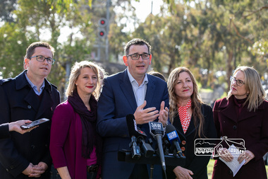
Photograph, Peter Pidgeon, Victorian Labor Government Press Release announcing planned upgrades to Hurstbridge line rail services and protection of historic Railway Trestle Bridge, Panther Place, Eltham, 1 August 2018, 1 Aug 2018
... Jacinta Allan, Minister for Public Transport, Panther Place, Premier Daniel Andrews, Press Announcement, Railway Line Construction, trestle bridge, Vicki Ward MP for Eltham, Victorian Parliament Born digital image (qty 27) Victorian Labor Government Press Release announcing planned upgrades to Hurstbridge line rail services and protection of historic Railway Trestle Bridge, Panther Place, Eltham, 1 August 2018 Photograph Peter Pidgeon ...Announcement by Premier Daniel Andrews, Minister for Public Transport, Jacinta Allan and Member for Eltham, Vicki Ward mad alongside the Eltham Railway Trestle Bridge. MEDIA RELEASE "More Trains And Fewer Delays On The Hurstbridge Line" https://www.premier.vic.gov.au/wp-content/uploads/2018/08/180801-More-Trains-And-Fewer-Delays-On-The-Hurstbridge-Line-1.pdf Commuters on the Hurstbridge line will have more trains, more seats and fewer delays with a re-elected Andrews Labor Government to continue its massive upgrade of the Hurstbridge line. The Andrews Labor Government said it would deliver locals in Melbourne’s north-east more peak hour train services and less time stuck at boom gates, and we have. The first stage of the Hurstbridge Line Upgrade has been delivered – six months early and on budget. This includes the new Rosanna Station, duplicated track between Heidelberg and Rosanna and the removal of the dangerous level crossings at Alphington and Rosanna. There’s more to do and only Labor will deliver the next stage of the Hurstbridge Line Upgrade to give local commuters more train services and a more comfortable commute. The $530 million project will include a brand new train station at Greensborough and the duplication of three kilometres of track between Greensborough and Montmorency, and 1.5 kilometres of track between Diamond Creek and Wattle Glen to allow more train services during the morning peak. This will allow trains to run every six and a half minutes at Greensborough, every 10 minutes at Eltham and Montmorency, and every 20 minutes at Hurstbridge, Diamond Creek and Wattle Glen – as well as two extra Hurstbridge express services. Locals on the Labor Government’s new Mernda line will also get five extra train services during the morning peak, with a major upgrade of the Clifton Hill junction where the Mernda and Hurstbridge lines connect. Labor will also protect the Eltham Trestle Bridge – the last remaining timber bridge on Melbourne’s electric train network – which has local heritage protection and is an important part of the area’s character. The Liberals will leave this bridge to rot and demolish the nearby childcare centre and football club with their under-cooked and under-costed promise to upgrade the Hurstbridge line. Only Labor will protect this important piece of Melbourne’s history with planning work to be carried out for a long-term solution as part of the project. Stage two of the Hurstbridge Line Upgrade will create more than 950 jobs, with construction to start in 2020 and finish by 2022. Quotes attributable to Premier Daniel Andrews “We said we’d upgrade the Hurstbridge line and remove dangerous and congested level crossings at Rosanna and Alphington and we did – but there’s more to do.” “Only Labor will deliver the next stage of the Hurstbridge Line Upgrade with a new Greensborough Station and more trains, more often.” Quote attributable to Minister for Public Transport Jacinta Allan “The former Liberal Government promised new train lines but didn’t deliver a single kilometre of track – now they’re promising a half-baked upgrade of the Hurstbridge line with rubbery figures that don’t add up.” Quote attributable to Member for Eltham Vicki Ward “As a fifteen year old hopping on Red Rattlers at Eltham I wanted to do something to make the Hurstbridge line better. It’s taken me a few decades but finally our line will offer the frequency of services that are expected and needed in a 21st century city.”Born digital image (qty 27)jacinta allan, minister for public transport, panther place, premier daniel andrews, press announcement, railway line construction, trestle bridge, vicki ward mp for eltham, victorian parliament -
 Otway Districts Historical Society
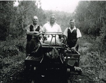
Photograph, Albert Denning, Colac track gang near Kawarren, c.1950
... Albert Denning, the son of a Gellibrand selector, worked at Driver's planing mill and Hitt's Lardner mill before joining Victorian Railways in 1928 as an engine cleaner at Beech Forest and Crowes, the last one in both places. ...Albert Denning, the son of a Gellibrand selector, worked at Driver's planing mill and Hitt's Lardner mill before joining Victorian Railways in 1928 as an engine cleaner at Beech Forest and Crowes, the last one in both places. ...In 1955 staff numbers were reduced to an absolute minimum with one track gang at Beech Forest and one at Colac, one of whose members resided at Gellibrand. No new sleepers were issued to the track gangs after 1955/56, cut down ones being used instead. Albert Denning, the son of a Gellibrand selector, worked at Driver's planing mill and Hitt's Lardner mill before joining Victorian Railways in 1928 as an engine cleaner at Beech Forest and Crowes, the last one in both places. He later became a track repairer at Gellibrand and worked with this and the Colac track gang until 1962. Bill Jamieson was a track repairer on the Colac-Gellibrand gang from the 1950s until 1962, and witnessed the official policy of minimum maintenance in the last years of the line.B/W. 201mm x 254mm. In c.1950, the Colac track gang near Kawarren, featuring, from left to right, Bill Jamieson, Albert Denning, and Don Loury on an NKS motor trolley..colac; kawarren; railways; track gangs; -
 Otway Districts Historical Society
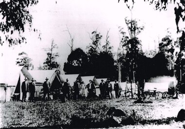
Photograph, Knox Collection, Survey camp for Colac-Beech Forest railway, 1901, 1901
... Plans for a rail connection between Colac and Beech Forest had been drawn up in 1884 and 1889 but proofed inconclusive because of the enormous cost involved in building a railway in such difficult terrain. Because of the financial depression in the early 1890s such expenditure went of hold. Towards the end of the decade planners recognised that a narrow gauge could be a viable alternative and it was taken up by the community, Parliamentary representatives and the government, although Victorian...Plans for a rail connection between Colac and Beech Forest had been drawn up in 1884 and 1889 but proofed inconclusive because of the enormous cost involved in building a railway in such difficult terrain. Because of the financial depression in the early 1890s such expenditure went of hold. Towards the end of the decade planners recognised that a narrow gauge could be a viable alternative and it was taken up by the community, Parliamentary representatives and the government, although Victorian ...Plans for a rail connection between Colac and Beech Forest had been drawn up in 1884 and 1889 but proofed inconclusive because of the enormous cost involved in building a railway in such difficult terrain. Because of the financial depression in the early 1890s such expenditure went of hold. Towards the end of the decade planners recognised that a narrow gauge could be a viable alternative and it was taken up by the community, Parliamentary representatives and the government, although Victorian Railways administration was against the idea. This was overridden. The 1898 Parliament approved a 2 foot 6 inch gauge from Colac to Beech Forest although strict financial limits were set. The route was to be the most direct and the infrastructure the most basic. Construction began in 1900 entailing very steep grades and myriad curves until it finished in 1902. Surveyors and their assistants came before and during the track laying for the whole distance.B/W. Survey camp for the Colac-Beech Forest railway in 1901, showing nine tents, ten men including a cook, survey instruments, and three bicycles. Note the cooking fire on the right.colac: beech forest; railways; survey; -
 Port Melbourne Historical & Preservation Society
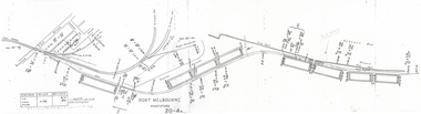
Plan - Victorian Railways 'single line diagram 'Port Store', Victorian Railways, Nov 1942
... Port Melbourne Historical & Preservation Society Port Melbourne Town Hall 333 Bay Street Port Melbourne melbourne Diagrams created by the Victorian Railways with detailed information including weight of rails, distance of points/switches from the datum point, etc. Victorian Railways Port Store Scanned copy of 'single line diagram' for 'Port Store' Scanned copy of 'single line diagram' for 'Port Store' Plan Victorian Railways 'single line diagram 'Port Store'. ...Diagrams created by the Victorian Railways with detailed information including weight of rails, distance of points/switches from the datum point, etc.Scanned copy of 'single line diagram' for 'Port Store'Scanned copy of 'single line diagram' for 'Port Store'victorian railways, port store -
 Port Melbourne Historical & Preservation Society
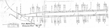
Plan - Victorian Railways 'single line diagram 'Princes Pier', Victorian Railways, Oct 1954
... Port Melbourne Historical & Preservation Society Port Melbourne Town Hall 333 Bay Street Port Melbourne melbourne Diagrams created by the Victorian Railways with detailed information including weight of rails, distance of points/switches from the datum point, etc. Victorian Railways Piers and Wharves - Princes Pier Scanned copy of 'single line diagram' for 'Princes Pier' Plan Victorian Railways 'single line diagram 'Princes Pier'. ...Diagrams created by the Victorian Railways with detailed information including weight of rails, distance of points/switches from the datum point, etc.Scanned copy of 'single line diagram' for 'Princes Pier'victorian railways, piers and wharves - princes pier -
 Bendigo Historical Society Inc.
Document - MINING IN BENDIGO COLLECTION: NAMES OF MINING SLIDES
... Railway... Healthy Golden Bendigo... Lansells 222... Lansell's Fortuna... Old Chum Mine... from New Chum Hill... to Victoria Hill... Plan of leases on Victoria Hill 1859... Lansell's Big 180... Bendigo & Vicinity... Victoria Quartz... Wm Rae's crushing Machine... Hercules & Energetic... Mungo Mines... United Devonshire... Mungo Group & Devonshire Mines 1888... Catherine Reef United... Garden Gully United... Knipe;s Castle... Old Carlisle... Nth Garden & Passby... Koch's Pioneer Quartz Crushing Battery... Great Northern Mine... Virginia Mine... Specimen Hill... New Argus... South New Moon... New Moon... Big Blue Mine... Eadie's Whim & Central Blue Mine... Fortuna Hustlers... Pictorial Photos of Victorian...History House 11 Mackenzie Street Bendigo goldfields BHS Collection DOCUMENT Gold mining in bendigo Mining in Bendigo Names of Mining Slides Bob Aulsbrook Ian Hendry New Chum Railway Healthy Golden Bendigo Lansells 222 Lansell's Fortuna Old Chum Mine from New Chum Hill to Victoria Hill Plan of leases on Victoria Hill 1859 Lansell's Big 180 Bendigo & Vicinity Victoria Quartz Wm Rae's crushing Machine Hercules & Energetic Mungo Mines United Devonshire Mungo Group & Devonshire Mines 1888 Catherine Reef United Garden Gully United Knipe;s Castle Old Carlisle Nth Garden & Passby Koch's Pioneer Quartz Crushing Battery Great Northern Mine Virginia Mine Specimen Hill New Argus South New Moon New Moon Big Blue Mine Eadie's Whim & Central Blue Mine Fortuna Hustlers Pictorial Photos of Victorian Views Hustler's Royal Reserve Mine - City Extended Hustler's Freehold - looking South Great Extended Hustlers Hustlers Reef Mine Central Nell Gwynne Cornish Boiler Lancashire Boiler Wannan's E'Drivers Guide Winding Engine - New Moon 20 Drill Air Compressor - New Moon 1904 Engine at Virginia Crushing Battery Lansell's 105 Head Crushing Battery Deeble's Pyrites Works Miner at Central Deborah Level at 1045 feet at New Moon Boring on a reef at Catherine Reef Deborah Mine 1000 ft level Mines Dep't Melb & Bendigo Engine beds Lansell's Big 180 New Hustlers Rae's Open Cut Ballerstedt's First Open Cut 3 of Early days of Bendigo Geo Lansell Typed copy and two handwritten copies of index to mining slides per Bob Aulsbrook, 30.12.69 and Ian Hendry. ...BHS CollectionTyped copy and two handwritten copies of index to mining slides per Bob Aulsbrook, 30.12.69 and Ian Hendry.document, gold, mining in bendigo, mining in bendigo, names of mining slides, bob aulsbrook, ian hendry, new chum railway, healthy golden bendigo, lansells 222, lansell's fortuna, old chum mine, from new chum hill, to victoria hill, plan of leases on victoria hill 1859, lansell's big 180, bendigo & vicinity, victoria quartz, wm rae's crushing machine, hercules & energetic, mungo mines, united devonshire, mungo group & devonshire mines 1888, catherine reef united, garden gully united, knipe;s castle, old carlisle, nth garden & passby, koch's pioneer quartz crushing battery, great northern mine, virginia mine, specimen hill, new argus, south new moon, new moon, big blue mine, eadie's whim & central blue mine, fortuna hustlers, pictorial photos of victorian views, hustler's royal reserve mine - city, extended hustler's freehold - looking south, great extended hustlers, hustlers reef mine, central nell gwynne, cornish boiler, lancashire boiler, wannan's e'drivers guide, winding engine - new moon, 20 drill air compressor - new moon 1904, engine at virginia crushing battery, lansell's 105 head crushing battery, deeble's pyrites works, miner at central deborah, level at 1045 feet at new moon, boring on a reef at catherine reef, deborah mine 1000 ft level, mines dep't melb & bendigo, engine beds lansell's big 180, new hustlers, rae's open cut, ballerstedt's first open cut, 3 of early days of bendigo, geo lansell -
 Ringwood and District Historical Society
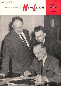
Magazine, Victorian Railways - Newsletter - June 1963
... Victorian Railways Public Relations and Betterment Board by direction of the Commissioners. Red, Black and White booklet with colour cover and black and white photographs. Contents include: The Month's Review; £30 Million plan ...Red, Black and White booklet with colour cover and black and white photographs. Contents include: The Month's Review; £30 Million plan for Flinders St.; Trades Behind the Trainl Holiday at 100; Recent Retirements list; Staff notes. etc. Published by the Victorian Railways Public Relations and Betterment Board by direction of the Commissioners. -
 Ringwood and District Historical Society
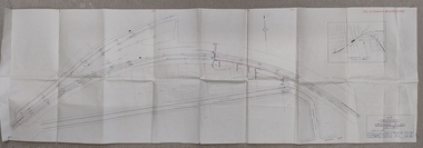
Plan, Victorian Railways letter to Ringwood Council re drainage with Attached Ringwood Railway Station and line plan 1938
... Victorian Railways letter to Ringwood Council re drainage with Attached Ringwood Railway Station and line plan 1938...Quarto cover letter from Victorian Railways to The Town Clerk, Ringwood Borough, Ringwood Dated 29th March 1938 re Council and propery owners "...pouring drainage and sewage into the railway drain, coloured red on the attached plan, without the authority of this Department...", and offering to allow this for an annual fee. ...Copy of Plan attached to this record also. Victorian Railways letter to Ringwood Council re drainage with Attached Ringwood Railway Station and line plan 1938 Plan ...Quarto cover letter from Victorian Railways to The Town Clerk, Ringwood Borough, Ringwood Dated 29th March 1938 re Council and propery owners "...pouring drainage and sewage into the railway drain, coloured red on the attached plan, without the authority of this Department...", and offering to allow this for an annual fee. Copy of Plan attached to this record also. -
 Ringwood and District Historical Society
Pamphlet, Victorian Railways Finance - A Constructive Plan to enable Freight and Fare Reductions c1947
... Ringwood and District Historical Society 125A Warrandyte Road Ringwood North melbourne Buff caloured Pamphlet published for Land Value Research Group, Surrey Hills, Victoria.Analysis of railways Revenue, Freight costs, State Land tax valuations, with the proposal being to segregate a portion of Land Tax to subsidise Railways revenue with a rate of 3d in the £1 being able to "give a eduction of all dfreights and fares of 31.7%" Victorian Railways Finance - A Constructive Plan to enable Freight and Fare Reductions c1947 Pamphlet ...Buff caloured Pamphlet published for Land Value Research Group, Surrey Hills, Victoria.Analysis of railways Revenue, Freight costs, State Land tax valuations, with the proposal being to segregate a portion of Land Tax to subsidise Railways revenue with a rate of 3d in the £1 being able to "give a eduction of all dfreights and fares of 31.7%" -
 Ringwood and District Historical Society
Booklet, Victorian Railways - The Hundredth Year 1953-54. Published January 1953
... Victorian Railways. Includes statistics, black and white photographs, with chapters on: More goods and passengers; Royal Passengers (Queen Elizabeth and Duke of edinburgh boarding train at Sale); New engines, carriages and trucks; Modernising Workshops (Newport); Track Work; Gippsland Line; Commercial Activities; Suburban Problems and Plans; Our Staff ...Victorian Railways Public Relations and Betterment Board by direction of the Commissioners. Red, Black and White 13 page booklet on the hundredth year of Victorian Railways. Includes statistics, black and white photographs, with chapters on: More goods and passengers; Royal Passengers (Queen Elizabeth and Duke of edinburgh boarding train at Sale); New engines, carriages and trucks; Modernising Workshops (Newport); Track Work; Gippsland Line; Commercial Activities; Suburban Problems and Plans; Our Staff Victorian Railways - The Hundredth Year 1953-54. ...Red, Black and White 13 page booklet on the hundredth year of Victorian Railways. Includes statistics, black and white photographs, with chapters on: More goods and passengers; Royal Passengers (Queen Elizabeth and Duke of edinburgh boarding train at Sale); New engines, carriages and trucks; Modernising Workshops (Newport); Track Work; Gippsland Line; Commercial Activities; Suburban Problems and Plans; Our Staff Published January 1953, by the Victorian Railways Public Relations and Betterment Board by direction of the Commissioners. -
 Ringwood and District Historical Society
Booklet, Victorian Railways - "Ready To Roll" December 1958
... red, Black and White booklet with black and white photographs, setting out current status and plans for Victorian railways. Contents include: Facts, Figures; Goods Traffic; Passenger Traffic; Goods Handing, Gauge stadardisation, Special Traffic; New Rolling Stock; Grade Separation; Trackwork etc; Central Reservation Bureau; Refreshment Services; Staff. ...Ringwood and District Historical Society 125A Warrandyte Road Ringwood North melbourne Published by the Victorian Railways Public Relations and Betterment Board by direction of the Commissioners. red, Black and White booklet with black and white photographs, setting out current status and plans for Victorian railways. ...red, Black and White booklet with black and white photographs, setting out current status and plans for Victorian railways. Contents include: Facts, Figures; Goods Traffic; Passenger Traffic; Goods Handing, Gauge stadardisation, Special Traffic; New Rolling Stock; Grade Separation; Trackwork etc; Central Reservation Bureau; Refreshment Services; Staff. Published by the Victorian Railways Public Relations and Betterment Board by direction of the Commissioners. -
 Flagstaff Hill Maritime Museum and Village
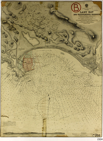
Document - Navigation Chart, Admiralty Office, Lady Bay and Warrnambool Harbour, 1893
... Victorian Government had commissioned Sir John Coode, a British harbour engineer, to present a plan to complete the Warrnambool Breakwater but his original plan was too expensive. He prepared a revised plan for a shorter structure. The construction proved to be too short to protect adequately from the weather and didn't allow enough depth for larger vessels to come into port. The decreasing trade was further affected by siltation in the bay due to the breakwater, and the completion of the railway...Victorian Government had commissioned Sir John Coode, a British harbour engineer, to present a plan to complete the Warrnambool Breakwater but his original plan was too expensive. He prepared a revised plan for a shorter structure. The construction proved to be too short to protect adequately from the weather and didn't allow enough depth for larger vessels to come into port. The decreasing trade was further affected by siltation in the bay due to the breakwater, and the completion of the railway ...This navigation cart of Lady Bay and Warrnambool Harbour was originally surveyed in 1870 but this version includes the update for magnetic variation in 1893. Since the printing of the chart several annotations have been added. These include an additional stamp dated 15-8-1910, a handwritten comment across the top of the page dated August 1910, and another handwritten comment regarding the ‘Proposed Extension of Dock’ dated 19-2-1925, plus connected drawings, notes and figures. The 1925 proposal on this chart may have been a reaction to the Royal Commission of 1923, when the damaged stonework on the seaward side of the Warrnambool Breakwater, caused by the action of the sea, was the subject of enquiry. A conference between the Public Works, Water Commission and the Harbour Trust concluded that it would less costly to make repairs to prevent further damage rather than replaced the damage portion of the wall. A contract was raised in late 1924 to deposit rubble on the damaged side of the breakwater to minimise the Southern Ocean’s destructive action and work had started by August 1925. The Breakwater construction had begun in 1874 and was completed in 1890. The Victorian Government had commissioned Sir John Coode, a British harbour engineer, to present a plan to complete the Warrnambool Breakwater but his original plan was too expensive. He prepared a revised plan for a shorter structure. The construction proved to be too short to protect adequately from the weather and didn't allow enough depth for larger vessels to come into port. The decreasing trade was further affected by siltation in the bay due to the breakwater, and the completion of the railway line. The situation of the harbour became a real problem by 1910 and required continuous dredging. In 1914 the Breakwater was extended but proved to be a failure because the work began to subside and by 1920 about two thirds of the harbour was silted up. Alterations made in the 1920's increased the silting problem and by the 1940's the harbour was no longer used. More alterations were made in the 1950's and 1960's. This chart is significant for its strong connection to the maritime history of Warrnambool Harbour and Lady Bay and the Warrnambool Breakwater. The Warrnambool Breakwater is registered as a place of significance on the Victorian Heritage Database (VHR H2024). The Warrnambool Breakwater is one of the most important late 19th century maritime engineering projects in Victoria and significant in the development of Victorian coastal shipping. It is also significant for its connection with British harbour engineer, Sir John Coode. The chart is a historical record of structures existing in 1893; the Warrnambool Jetties, Warrnambool Breakwater in Lady Bay, the leading lights (lighthouses), streets, roads, bridges and many buildings. It also shows the lay of the land and seabed. Navigation Chart: Lady Bay and Warrnambool Harbour, Australia - South Coast - Victoria. Surveyed by Nav. Lieut. H.J. Stanley, R.N., 1870. Updated for Magnetic Variation, 1893. The rectangular chart is printed on heavy cream paper. Stamps are shaped rectangular, oval and round. Around the Breakwater and Jetty area are handwritten notes, dotted and joined lines, numbers and signatures, and shading of red and green. The chart shows the surrounds of Warrnambool Harbour, Lady Bay, the Breakwater and Jetty, roads, bridges and the streets in Warrnambool. It has sounding details, and angles of line from the leading lights.Stamp, rectangular, including "AUG 1910" Stamp, double oval " - - - -CHART" Stamp, hand drawn, red circle, with "B" inside Hand written note "22-8-1910 - - - - - of surveying C. Ca - - - request of 15-8-10 [initials] " Notes and lines in red pen, including a grid of sounding numbers: "1300" "1050" "1200" "Possible Extension of Dock" "19-2-25" "Dock Dredged to 20 Ft" Notes and lines in blue pen "Extension of Dock to accommodate vessels drawing 20 Feet" and "Light not visible south of this line" Red dots (4) with yellow highlight at both leading lights, breakwater and jettyflagstaff hill, warrnambool, flagstaff hill maritime museum & village, maritime museum, maritime village, shipwreck coast, map, chart, navigation chart, plan, lady bay, warrnambool harbour, port of warrnambool, breakwater, jetty, pier, dock extension, proposed extension, vhr h2024, 1870, 1893, 1910, 1925, warrnambool town late 1800s, warrnambool streets late 1800s royal commission, 1923, public works, water commission, harbour trust, victorian harbours, sir jon coode -
 Flagstaff Hill Maritime Museum and Village
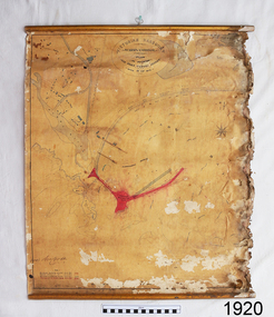
Document - Plan, Victorian Harbours Warrnambool, Victorian Harbours, Warrnambool, Plan to Accompany Sir John Coode's Report, 28-02-1879
... Victorian Government commissioned him to present a plan to complete the Warrnambool Breakwater. His original plan was too expensive so he prepared a revised plan for a shorter structure. The work was completed in 1890. The construction proved to be too short to protect adequately from the weather and didn't allow enough depth for larger vessels to come into port. The decreasing trade was further affected by siltation in the bay due to the breakwater, and the completion of the railway...Victorian Government commissioned him to present a plan to complete the Warrnambool Breakwater. His original plan was too expensive so he prepared a revised plan for a shorter structure. The work was completed in 1890. The construction proved to be too short to protect adequately from the weather and didn't allow enough depth for larger vessels to come into port. The decreasing trade was further affected by siltation in the bay due to the breakwater, and the completion of the railway ...This plan is of great significance to the local history of Warrnambool, in particular the Breakwater and its impact on Warrnambool's maritime and trade history. The plan shows the existing jetties at the Port of Warrnambool, plus the partially erected Breakwater and proposed works to the Breakwater by both the Borough of Warrnambool Surveyor and Sir John Coode. The plan was signed 28th February 1879 by Sir John Coode. The legend at the bottom left describes the existing works and the proposed works. The Warrnambool Breakwater Sir John Coode was a British harbour engineer. He was brought to Melbourne by the Melbourne Harbour Trust to advise on works to improve the Port of Melbourne. The Victorian Government commissioned him to present a plan to complete the Warrnambool Breakwater. His original plan was too expensive so he prepared a revised plan for a shorter structure. The work was completed in 1890. The construction proved to be too short to protect adequately from the weather and didn't allow enough depth for larger vessels to come into port. The decreasing trade was further affected by siltation in the bay due to the breakwater, and the completion of the railway line. The situation of the harbour became a real problem that, by 1910, required continuous dredging. In 1914 the Breakwater was extended but proved to be a failure because the work began to subside and by 1920 about two thirds of the harbour was silted up. Alterations made in the 1920's increased the silting problem and by the 1940's the harbour was no longer used. More alterations were made in the 1950's and 1960's. The Warrnambool Breakwater is registered as a place of significance on the Victorian Heritage Database. This plan of the proposed works for the existing Warrnambool Breakwater is of great significance to the local history of Warrnambool, in particular the Breakwater and its impact on Warrnambool's maritime and trade history. The Warrnambool Breakwater is registered as a place of significance on the Victorian Heritage Database (VHR H2024). It is historically significant to Victoria as one of the most important maritime engineering projects in Victoria in the late 19th century. The Warrnambool Breakwater is of historical significance as one of the most important maritime engineering projects in Victoria in the late nineteenth century. It is evidence of Victoria's nineteenth century investment in regional port infrastructure and the development of Victorian coastal shipping. It is of significance for its association with the English civil engineer Sir John Coode, the most distinguished harbour engineer of the nineteenth century, who was brought to Victoria to advise on works to improve the Port of Melbourne, but was retained by the Government to advise on improvements to the harbours at Portland, Geelong, Port Fairy, and Lakes Entrance, as well as Warrnambool. His projects for Melbourne, Lakes Entrance and Warrnambool were major engineering projects of the nineteenth century. The breakwater is historically significant as a reminder of Warrnambool's early maritime history as a Western District port, and as one of Victoria's major 'outer ports'. While the Warrnambool Breakwater is a demonstration of the engineering skills of the nineteenth century, it also demonstrates the limitations of knowledge relating to sedimentology at the time and the confidence apparent in a number of nineteenth century plans which assumed that natural forces could be overcome or contained by engineering.Plan of Warrnambool Harbour, Port of Warrnambool, dated 28 Feb 1879. Plan shows existing Breakwater and work proposed by both Warrnambool Borough Surveyor and Sir John Coode. Plan has gold coloured quarter-dowel rods top and bottom and a metal ring at the top. Stamped with title. Signed by Sir John Coode.Stamped "VICTORIAN HARBOURS / WARRNAMBOOL / PLAN / to accompany / SIR JOHN GOODE'S REPORT / DATED 28 FEB 1879" Signature "John Coode"flagstaff hill, warrnambool, maritime museum, shipwreck coast, great ocean road, sir john coode, borough of warrnambool surveyor, plan of warrnambool, victorian harbours, warrnambool harbour, warrnambool breakwater, port of warrnambool, vhd vhr h2024, flagstaff hill maritime museum & village, maritime village, map, chart, plan, lady bay, breakwater, jetty, pier, vhr h2024, proposed works, 1879 -
 Federation University Historical Collection
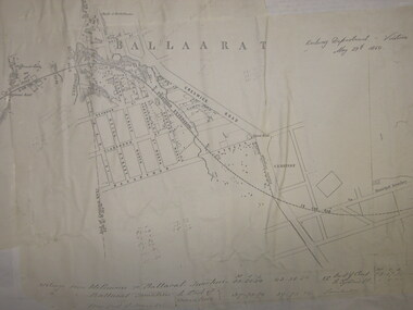
Plan, Ballarat Railway Plan, 1860, 29/05/1860
... plan was created by the Railway Department, Victoria. ballarat railway ballarat Photocopy of the Melbourne to Ballarat via Geelong Railway plan. The section is the area adjoining Bakery Hill, Ballarat. The plan shows the Yarrowee River, central Ballarat, Government Camp, Imperial Hotel, Union Hotel, Crown hotel, electric Telegraph line, Eureka Lead, Black Hill Lead, Ballaarat Old Cemetery., Bank of Australasia. Ballarat Railway Plan, 1860 Plan Plan Department of tracks and Drainage - Victorian ...This plan was created by the Railway Department, Victoria.Photocopy of the Melbourne to Ballarat via Geelong Railway plan. The section is the area adjoining Bakery Hill, Ballarat. The plan shows the Yarrowee River, central Ballarat, Government Camp, Imperial Hotel, Union Hotel, Crown hotel, electric Telegraph line, Eureka Lead, Black Hill Lead, Ballaarat Old Cemetery., Bank of Australasia.ballarat railway, ballarat -
 Federation University Historical Collection
Book, Victorian Government Legislative Assembly, The Select Committee on Castlemaine and Sandhurst water supply, Report from the Select Committee on Castlemaine and Sandhurst Water Supply, together with the proceedings of the Committee, minutes of evidence and appendices, 19/5/1865 (exact)
... Railways, and reply of the Chief Engineer of Water Supply on the works constructed by the Victorian Water Supply Department, presented to both houses of parliament by His Excellency’s command. Ferdinand M. Krause, was a lecturer at the Ballarat School of Mines in Geology Mineralogy Mining Engineering and Surveying. He was a Fellow of the Geological Society and a Fellow of the Linnian Society. He was assistant engineer for the Ballaarat and Ballarat East Water Supply Committee and helped plan...Victorian Water Supply, Castlemaine and Sandhurst district general plan including lines of Aqueduct, Reservoirs. No. 7082.3 of Victorian Mining districts, Mining Divisions and The Gold Fields in 1866 - includes districts to be supplied under the Waterworks Act, 1965. It also includes: *Report of the Engineer-in-chief of Railways...Victorian Water Supply, Castlemaine and Sandhurst district general plan including lines of Aqueduct, Reservoirs. No. 7082.3 of Victorian Mining districts, Mining Divisions and The Gold Fields in 1866 - includes districts to be supplied under the Waterworks Act, 1965. It also includes: *Report of the Engineer-in-chief of Railways ...This book contains the report from the select committee on Castlemaine and Sandhurst water supply; with the proceedings of the committee, minutes of evidence and appendices. It also contains the report Of the Engineer-In-Chief of Railways, and reply of the Chief Engineer of Water Supply on the works constructed by the Victorian Water Supply Department, presented to both houses of parliament by His Excellency’s command. Ferdinand M. Krause, was a lecturer at the Ballarat School of Mines in Geology Mineralogy Mining Engineering and Surveying. He was a Fellow of the Geological Society and a Fellow of the Linnian Society. He was assistant engineer for the Ballaarat and Ballarat East Water Supply Committee and helped plan local reservoirs.A brown cloth hard cover, foolscap book with leather spine. Title is written in black on the title page. "Water Supply Reports" is engraved in gold on spine. It includes a table showing the monthly and yearly rainfall and shade temperature at Ballarat, 2nd February, 1885. It also includes two reports and two replies, a map No.7082.2 of Victorian Water Supply, Castlemaine and Sandhurst district general plan including lines of Aqueduct, Reservoirs. No. 7082.3 of Victorian Mining districts, Mining Divisions and The Gold Fields in 1866 - includes districts to be supplied under the Waterworks Act, 1965. It also includes: *Report of the Engineer-in-chief of Railways and Reply of the Chief Engineer of Water Supply on the works constructed by the Victorian Water Supply Department, 1869. * Coliban Water Scheme, 1864 * Ballarat and Ballarat East Water Supply (1869) including the Ballarat Water Supply List containing names of occupiers and nature of improvements on lands comprised within the proposed reserve of Gong Gong Reservoir, Ballaarat. At Warrenheip the names included: Honora McCallin, William Honan, C. McMahon, Patrick McMahon, J.P. Beach, J.H. Smith, Michael Nestor, Martin Quinn, Martin McIntyre, Robert Higgins, Coleman Kane, Robert Bond. At Ballarat: William Clarke, Richard White, John Hosking, Wesleyan Chapel, J. Hewitt, Robert McRobinson. At Bungaree: John Pullin, John Llewellyn. William Daw, Smith and Wynne, William Brough, A. Alexander. * Ballarat and Ballaarat East Water Supply report upon the advisability, or otherwise, of constructing a reservoir at the junction of the Yarrowee Creek and Gile's Creek, upon a site known as Gile's Reservoir (printed by Frank Pinkerton). This report has numerous notes written on it (most probably by Krause) and includes the capacity of Harry Beale's Reservoir, Pimcott's Reservoir and the Proposed Gong Gong Reservoir. * Statement as to the position of the Ballaarat and Ballaarat East Borough Councils in Connection with Water Supply, September 1869. * Ballarat and Ballaarat East Water Supply - General Statement upon the Ballaarat and Ballaarat east Scheme of Water Supply. Includes information on Moorabool reservoir, Harry Beale's Reservoir, Lal Lal Creek, Two Mile Creek, Beale's Dam, Yarrowee Creek, Gong Gong Reservoir, Kirk's Dam, Devil's Creek, Moorabool Creek. Additional handwritten notes (probably by Krause) * Engineer's Report on the resolution of the COmmittee of Water Supply, of the 7th July 1868. The report refers to the Country around Mount Warrenheip. Names mentioned are L. Abraham, Great North-West Gold Mining Company, Border Sawmills, Ferdinand Krause, Ohlfsen Bagge, W.H. Shaw, A signature by "Ferdinand M. Krause" at the top corner of the title page. A few pages have handwriting on the margins, it is believed to be his handwriting. water supply victoria, castlemaine directories, sandhurst directories, ballarat directories, james blackburn, edward wardle, daylesford water race, c j taylor, george avery fletcher, bagge, ohlfsen bagge, george foote, john h reilly, ambrose johnson, george francis, timber preservation, james forbes, alfred surplice, malcolm carmichael, robert adams, frederick hugh thomas, h o christerpherson, william downe, thomas lawrence brown, francis hadgson nixon, strangways, guildford, maldon, muckleford, lauriston, malmesbury, franklinford, walmer, strathloddon, downe, ferdinand krause, m7082, trentham, castlemaine, drummond, metcalfe, sutton grange, lockwood, ravenswood, mandurang, yandoit, c.h. ohlfsen bagge, moorabool reservoir, gong gong reservoir, harry beale's reservoir, pincott reservoir, frank pinkerton, water -
 Ballarat Tramway Museum
Newspaper, Herald & Weekly Times Ltd, "Truck, tram collide", "Group charters tram", "Ballarat plans tram museum", 1971
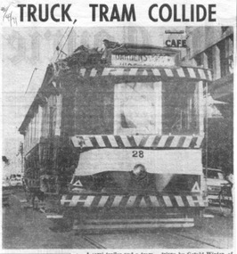
... Original of newspaper of item 1 - also has items about the future of the railway workshops following a cost review and a story of page 1 of a submission to the Victorian Land Transport enquiry. "Truck, tram collide", "Group charters tram", "Ballarat plans tram museum" Newspaper Herald & Weekly Times Ltd. ...Set of three newspaper clippings pasted onto a single sheet of paper with two Punch holes on the left hand side. First clipping from The Courier, Ballarat, 2/4/1971 with photo of tram 28 after is collision the previous day with a semi-trailer at the intersection of Princes and Victoria Streets. Gives names of the vehicle drivers and cost of the damage. Photo is of the tram returning to the depot under its own power. Tram passenger named as Margaret Foley, tram driven by James Mason and the truck driven by Gerald Winter of Gordon. See Reg Item 672.1 for a print of the Courier Photograph. Second is from The Courier, Ballarat, 15/4/1971 of the Brown Hill Progress Association chartering a tram to create interest in the project for the retention of Ballarat's trams. The tram was to leave Drummond and Sturt St. intersection the following Sunday at 1245. Item mentions the election of an interim executive and expression of interest of people outside the city. Third is from The Sun, Melbourne, 31/5/1971 about Ballarat 'tram-lovers' deciding to have a working tramway museum. Quotes Mr. Paul Nicholson, a member of the Ballarat Tramway Preservation Society. Notes that Museum will have eight trams using two miles of existing track around Lake Wendouree. Also notes that the SEC had received 88 applications for the 44 trams in both Ballarat and Bendigo.Image of the 3rd item added 28/3/2011 - see i1 and for the actual cutting i4. Original of newspaper of item 1 - also has items about the future of the railway workshops following a cost review and a story of page 1 of a submission to the Victorian Land Transport enquiry.In red ink on first cutting in top left hand corner "2/4/71" and in blue ink in top right hand corner on second cutting "15/4/71".trams, tramways, accidents, closure, charters, museum establishment -
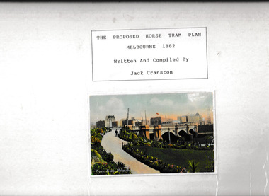 Victorian Railway History Library
Book, Cranston, Jack et al, The proposed horse tram plan for Melbourne 1882, ????
... Victorian Railway History Library 39 St Edmonds Rd Prahran Prahran Horse tramways - Melbourne Urban transportation - Melbourne Illustrations and plans for the proposed horse tram plan for Melbourne 1882 Ill, maps, p.66. ...Illustrations and plans for the proposed horse tram plan for Melbourne 1882Ill, maps, p.66.non-fictionIllustrations and plans for the proposed horse tram plan for Melbourne 1882horse tramways - melbourne, urban transportation - melbourne -
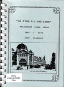 Victorian Railway History Library
Book, Jack Cranston, On time all the time: Melbournes cable trams 1885-1940, ????
... Victorian Railway History Library 39 St Edmonds Rd Prahran Prahran Urban transportation - Melbourne Cable trams - Melbourne Illustrations and plans of Melbournes cable trams 1885-1940. ...Illustrations and plans of Melbournes cable trams 1885-1940.Ill, plans, p.67.non-fictionIllustrations and plans of Melbournes cable trams 1885-1940.urban transportation - melbourne, cable trams - melbourne -
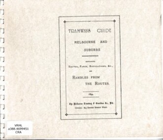 Victorian Railway History Library
Book, Jack Cranston, Tramways guide: Melbourne and suburbs containing routes, fares, regulations and rambles from the routes, 1894
... Victorian Railway History Library 39 St Edmonds Rd Prahran Prahran Urban transportation - Melbourne Cable trams - Melbourne Reprint of an 1894 guide with Illustrations, routes, descriptions and plans of Melbourne's cable trams 1885-1940. facsimile, Ill, maps, p.41. ...Reprint of an 1894 guide with Illustrations, routes, descriptions and plans of Melbourne's cable trams 1885-1940.facsimile, Ill, maps, p.41.non-fictionReprint of an 1894 guide with Illustrations, routes, descriptions and plans of Melbourne's cable trams 1885-1940.urban transportation - melbourne, cable trams - melbourne