Showing 83 items matching "weather station"
-
 Moorabbin Air Museum
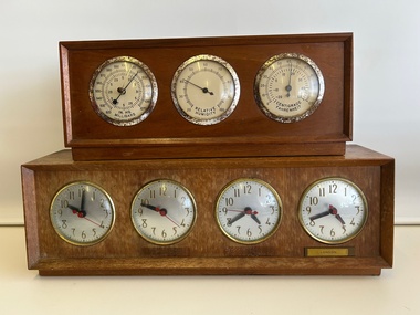
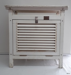
Instrument (item) - Weather Station, comprising , Barometer ,Hygrometer & Thermometer with Time Zone Clock. From the desk of Frank Pascoe General Manager Ansett-ANA, Weather Station, comprising , Barometer ,Hygrometer & Thermometer with Time Zone Clock
... Weather Station, comprising , Barometer ,Hygrometer & Thermometer with Time Zone Clock. ...Weather Station, comprising , Barometer ,Hygrometer & Thermometer with Time Zone Clock. ...Weather Station, comprising , Barometer ,Hygrometer & Thermometer with Time Zone Clock. ...Instrument Weather Station, comprising , Barometer ,Hygrometer & Thermometer with Time Zone Clock. ... -
 University of Melbourne, Burnley Campus Archives
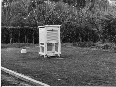
Photograph - Black and white print, E.M. Gibson, Weather Station, 1947
... Weather Station...weather station...Black and white photograph of the Weather Station in the Agrostology area....University of Melbourne, Burnley Campus Archives 500 Yarra Boulevard Richmond melbourne weather station agrostology e. m. gibson collection 76/27 Black and white photograph of the Weather Station in the Agrostology area. ...Black and white photograph of the Weather Station in the Agrostology area.76/27weather station, agrostology, e. m. gibson collection -
 Federation University Historical Collection
Document - Document - Letter, Ballarat Junior Technical School: Letters relating to equipment to establish a practice weather-observation station. 1952
... Ballarat Junior Technical School: Letters relating to equipment to establish a practice weather-observation station. 1952......weather station...Outlines establishing a weather-observing station as part of general science. ...Outlines establishing a weather-observing station as part of general science. ....1: Letter from H B Selby & Co Pty Ltd re the order for a Fortin Barameter. Asking for arrangement for Staff member to collect as it is very fragile. The glassware for the Regnault Vapour pressure Apparatus not previously sent has been forwarded. .2: Letter from the school to The Director Weather Bureau Melbourne. Outlines establishing a weather-observing station as part of general science. Mr McLachlin in Ballarat will guide the school as to method, procedure, records, etc List of equipment on loan - Stevenson Screen, maximum and minimum thermometers, wet and dry bulb thermometers, 8" rain gauge, cloud chart, instructions for reductions of barometer readings, weather code for transmission, record book. 2 Cream pages, typed .1: Letterhead for H B Selby & Co Pty Ltd - Black and red inks Signature of V T Parkinson, Managerballarat junior technical school, head master, l garner, h b selby, weather bureau, weather station, observations, fortin barameter, regnault vapour pressure apparatus, stevenson screen, maximum thermometer, minimum thermometer, bulb thermometers, rain gauge, instructions, weather code, record book -
 Myrtleford and District Historical Society
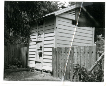
Weather Station
... Weather Station...Myrtleford and District Historical Society 29 Elgin Street Myrtleford high-country Weather Station ... -
Yarrawonga and Mulwala Pioneer Museum
Yarrawonga Weather Station
... Yarrawonga Weather Station...Yarrawonga and Mulwala Pioneer Museum 151 Melbourne St, Mulwala Yarrawonga Weather Station ... -
 Eltham District Historical Society Inc
Slide - Photograph, Never Wrong Weather Station, Eltham, 23 May 1993
... Never Wrong Weather Station, Eltham...A number of significant trees and buildings were also highlighted along with the opportunity to explored some of the properties. activities shire of eltham historical society heritage excursion eltham houses 35mm colour positive transparency (1 of 24) Mount - Kodak Kodachrome Never Wrong Weather Station, Eltham Slide Photograph ...The 1993 Eltham Heritage Tour was enjoyed by a busload of members of the Historical Society on a fine, calm day, Sunday May 23rd. Between 10.00 am and 4.30 pm, except for a brief lunch stop at the Eltham Living and Learning Centre, members passed about thirty places of local interest and others recommended for the Historic Buildings Register and the Register of the National Estate. A number of significant trees and buildings were also highlighted along with the opportunity to explored some of the properties.35mm colour positive transparency (1 of 24) Mount - Kodak Kodachromeactivities, shire of eltham historical society, heritage excursion, eltham, houses -
 Flagstaff Hill Maritime Museum and Village
Equipment - Stevenson Screen, Thomas Stevenson, ca. 1910
... ...weather station...Sometimes other meteorological instruments were included in the weather stations, so there were different Stevenson Screen sizes. ...Stevenson screen, original, from the Australian Bureau of Meteorology’s weather station at the Cape Otway Lighthouse. The screen is a white wooden cupboard with a slanted cover raised above the top. ...Sometimes other meteorological instruments were included in the weather stations, so there were different Stevenson Screen sizes. ...Stevenson screens were first introduced in Australia in the 1880s and were widely installed by 1910. The screens have been used to shelter and protect thermometers and other meteorological instruments from rain and direct heat while the holes and double-louvre walls allowed air to flow around them. Sometimes other meteorological instruments were included in the weather stations, so there were different Stevenson Screen sizes. This authentic, original Stevenson screen was previously owned by the Australian Bureau of Meteorology and was used for many years for weather readings at the Cape Otway Light Station in southwest Victoria. The Lighthouse Keepers recorded the readings for minimum and maximum temperatures at 9 a.m. every day from January 1865 until April 1994. The equipment was sheltered in a Stevenson Screen from 1902 until April 15 1994, when the mercury thermometer was replaced by a platinum resistance probe within an Automatic Weather Station (AWS). This Stevenson screen is one of the two screens that then became redundant. The other Stevenson screen was kept to display to visitors. Lightkeepers were no longer required at the Cape Otway Light station either, due to the automated system. The meteorological instruments donated with the screen were used for measuring temperature and humidity. They are mounted on a metal bracket that fits across the screw holes on the screen’s internal frame. The glass-covered Relative Humidity (RH) sensor was made by the renowned precision instrument maker, Rotronic AG of Switzerland, which was founded in 1965. The firm made its first electronic temperature and humidity instrument in 1967. Meteorological records have been collected in Australia from the 1800s. The records were collated, published and used as a basis for weather forecasts. Many sectors, such as maritime and agriculture industries, have relied on these figures for making important decisions. The quality and placement of the meteorological instruments used to measure temperature and humidity are of utmost importance for accuracy. In early colonial times, there were no national standards for meteorological instruments that would allow for accurate figures and comparisons. Once the Bureau of Meteorology was established (around 1908 to 1910) the department installed Stevenson screens throughout Australia, many at lighthouses and light stations, and the measuring instruments were standardised. The Stevenson Screen was named after its inventor, Scottish Civil Engineer Thomas Stevenson (1818-1887) who was also the father of Robert Louis Stevenson, author. Stevenson developed the small thermometer screen around 1867. It had double-louvred walls around the sides and a top of two asbestos sheets with an air space between them and was thickly painted with a white coating that reflected the sun’s rays. This design was modified in 1884 by Edward Mawley of the Royal Meteorological Society. Standards were set for the locations of the screens and instruments, including their distance above ground level and the direction the door faced.Stevenson screens played a significant part in providing a standardised shelter for all meteorological instruments used by the Australian Bureau of Meteorology from about 1910 until 1994. The readings from the instruments gave the meteorological statistics on which weather forecasts throughout Australia were based. This Stevenson screen was used locally at Cape Otway, along the Great Ocean Road in southwest Victoria, so contributed towards our local forecasts and weather warnings.Stevenson screen, original, from the Australian Bureau of Meteorology’s weather station at the Cape Otway Lighthouse. The screen is a white wooden cupboard with a slanted cover raised above the top. The top has ten drilled ventilation holes, and the sides and door are made of downward-slanting double louvres. Two brass hinges join the door to the lower edge of the screen and a metal fitting at the top edge allows for a padlock closure. The screen is supported on four short legs, each with a hole drilled from side to side for fitting to a frame. Inside the screen are two wooden frames fitted with hooks and screws. The floor has three boards; one across the back and one across the front at the same level, and a board wider than the space between these boards is fitted higher, overlapping them slightly. Inside the screen, a pair of electronic instruments with short electric cables is mounted on a metal bracket with drilled holes in it. One of the instruments is a Relative Humidity (RH) probe. It is 26 cm long and is a glass tube with a filter on one end and an electrical connection on the other. It has inscriptions on its label, showing that was made by Rotronic AG, Switzerland. The other instrument is a Resistance Temperature Device (RTD) thermometer. It is 22.5 cm long and has a narrow metal probe joined to a hexagonal metal fitting. A brass plate on the front of the screen has impressed inscriptions. The screen is Serial Number 01/C0032, Catalogue Number 235862.Stamped into brass plate "CAT. NO. / 253862 / SERIAL NO. 01/C0032" On instrument’s electrical fitting; “CD2” [within oval ‘+’ above S] “Serie693 op65 / 220/380V~16A” On instrument’s glass; “rotronic ag” “SWISS MADE” “CE / CH-8303 / Bassersdorf” Symbol for [BARCODE] “ART NO MP 101A_T4-W4W” “POWER 4.8.30VDC“ “OP. RANGE: 0-100%RH/-40+60° C” “OUT H 0-100% 0-1V” “OUT T -40+60°C -0.4..+0.6V” “SERIE NO 19522 009”flagstaff hill maritime museum and village, warrnambool, maritime museum, maritime village, great ocean road, shipwreck coast, cotton region shelter, instrument shelter, thermometer shelter, thermoscreen, thermometer screen, measuring instruments, meteorological instrument, weather recording, weather station, lighthouse equipment, light station equipment, stevenson screen, marine instruments, mercury thermometer, platinum resistance probe, aws, automatic weather station, rotronic ag, swiss made, meteorological device, weather forecast, weather prediction, weather records, meteorological forecast, meteorological record, australian bureau of meteorology, bureau of meteorology, bureau, bom, relative humidity, rh, relative humidity probe, resistance temperature device, rtd, thermometer, temperature, humidity, cape otway, cape otway lighthouse, cape otway light station, rotronic, switzerland, swiss instrument, thomas stevenson, double-louvered walls, edward mawley, royal meteorological society, 01/c0032, serial number, cat. no. 235862, serial no. 01/c00323 -
 Sunshine and District Historical Society Incorporated
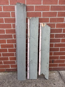
Functional object - Sunshine Railway Station Building Weather Boards
... Sunshine Railway Station Building Weather Boards...The boards are painted green Functional object Sunshine Railway Station Building Weather Boards ...These weatherboards were collected when the form wooden station building was being demolished as part of the worked for the Region Railway Line being constructed between Southern Cross Statation and Geelong Station.3 sections of weatherboards from the former wooden Sunshine Railway Station. The boards are painted green -
 University of Melbourne, Burnley Campus Archives
Instrument - Mercury Barometer and Thermometer, A.L. Franklin, Early twentieth century
... weather station...University of Melbourne, Burnley Campus Archives 500 Yarra Boulevard Richmond melbourne weather station soil science science student outside activities measurements air pressure atmospheric pressure air temperature artifact A.L.Franklin, established 1919, scientific instrument makers, Brookvale, NSW; A.L Franklin Sydney No. 457; Townson and Mercer Distributors Pty Ltd throughout Aust and NZ.; A Fortin style mercury barometer from well-known Australian instrument maker, A.L.Franklin. ...A Fortin style mercury barometer from well-known Australian instrument maker, A.L.Franklin. The column of mercury is supported by the pressure of air on the free surface of the mercury in the cistern at the bottom. Its level can be adjusted to a datum using the screw at the bottom and then the height of the column can be accurately read off using a vernier scale at the top. Attached to a backing timber board with a thermometer. Thermometer made by Townson and Mercer. Metal vertical hanging eyelet.A.L.Franklin, established 1919, scientific instrument makers, Brookvale, NSW; A.L Franklin Sydney No. 457; Townson and Mercer Distributors Pty Ltd throughout Aust and NZ.;weather station, soil science, science, student outside activities, measurements, air pressure, atmospheric pressure, air temperature, artifact -
 Lakes Entrance Historical Society
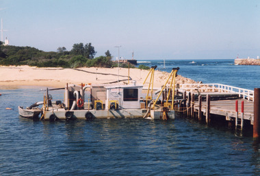
Photograph, Sand Dredge Lakes Entrance Victoria
... Scrub on dune, flagstaff and weather station on dune - top left. Entrance and tip of western pier top right. ...Scrub on dune, flagstaff and weather station on dune - top left. Entrance and tip of western pier top right. ...Colour photograph of transfer pump moored to north end of Eastern Pier. Dredged sand on beach showing pipe line from dredge across sand. Scrub on dune, flagstaff and weather station on dune - top left. Entrance and tip of western pier top right. Lakes Entrance Victoriaboats and boating, dredging, beaches -
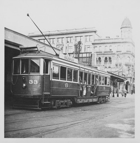
 Melbourne Tram Museum
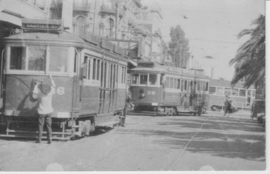
Photograph - VR tram 36, 29 at St Kilda Station, 12 January 1954
... St Kilda Railway Station...weather...station. VR tram 29 is also arriving at the terminus with weather blinds and saloon sunshades raised to shunt over tram 36. ...Yields information about St Kilda Railway Station VR 36, Vr 29, and tram operations VR tram St Kilda Railway Station weather blinds Middle Brighton tram 36 tram 29 Brighton Beach Vautier St limited express intermediate terminus M&MTB W2 Fitzroy St Acland St In ink on the rear " 36,29, &a W2 at M&MTB/VR crossing St Kilda Stn 12-1-54 1035" Sepia photograph with note on the rear. ...The photograph shows VR tram 36 at St Kilda Railway Station with the driver in summer jacket raising the rear trolley pole. The tram displays destination Vautier St, an intermediate terminus about three kms from the station. VR tram 29 is also arriving at the terminus with weather blinds and saloon sunshades raised to shunt over tram 36. Its destination sign is indistinct but appears to be Middle Brighton or Brighton Beach. This movement of multiple shunting was common in the afternoon peak. Up to three trams would depart simultaneously following the arrival of a busy electric train from the city. The first tram would travel limited express to Brighton Beach; the second tram also ran limited express to the intermediate terminus at Middle Brighton; the last tram stopped all stops to Vaitier St, then return to repeat the same run. Also in the photograph is a M&MTB W2 tram in Fitzroy St crossing the VR tracks bound for its Acland St, St Kilda Beach terminus.Yields information about St Kilda Railway Station VR 36, Vr 29, and tram operationsSepia photograph with note on the rear.In ink on the rear " 36,29, &a W2 at M&MTB/VR crossing St Kilda Stn 12-1-54 1035"vr tram, st kilda railway station, weather blinds, middle brighton, tram 36, tram 29, brighton beach, vautier st, limited express, intermediate terminus, m&mtb, w2, fitzroy st, acland st -
 Melbourne Tram Museum
Photograph - VR tram 48 at Sandringham Station, K J Magor
... ...Sandringham Station...weather...The photograph shows VR tram 48 waiting to depart Sandingham Station terminus with many passengers in summer clothing and displaying the destination Sandringham. The weather...Yields information about Sandringham Station terminus VR Trams saloon windows destination Sandringham Station weather blinds summer clothing station building in ink on the rear "No 48 at Sandringham Station terminus K J Magor Neg No. 893" Black and white photograph with note on the rear. ...The photograph shows VR tram 48 waiting to depart Sandingham Station terminus with many passengers in summer clothing and displaying the destination Sandringham. The weather blinds are up and all saloon windows are open. The station building is seen behind the tram and to the left many adults and children stand together. Yields information about Sandringham Station terminusBlack and white photograph with note on the rear.in ink on the rear "No 48 at Sandringham Station terminus K J Magor Neg No. 893"vr trams, saloon windows, destination, sandringham station, weather blinds, summer clothing, station building -
 Lakes Entrance Historical Society
Photograph - Ray, Lakes Post Newspaper, 1992
... Black and white photograph of a group of people Peter Dawson Weather Bureau Inspector for Victoria, Graham Duff Regional Operations Manager for Weather Bureau, Barbara and Frank Ray, Tony Langiano taken on the occasion of the retirement of Barbara Ray after 27 years at the Victorian Bureau of Meteorology Weather Station Myers Street Lakes Entrance...Lakes Entrance Historical Society 4 Marine Parade Lakes Entrance gippsland Genealogy retirement Black and white photograph of a group of people Peter Dawson Weather Bureau Inspector for Victoria, Graham Duff Regional Operations Manager for Weather Bureau, Barbara and Frank Ray, Tony Langiano taken on the occasion of the retirement of Barbara Ray after 27 years at the Victorian Bureau of Meteorology Weather Station Myers Street Lakes Entrance Photograph Ray Lakes Post Newspaper ...Black and white photograph of a group of people Peter Dawson Weather Bureau Inspector for Victoria, Graham Duff Regional Operations Manager for Weather Bureau, Barbara and Frank Ray, Tony Langiano taken on the occasion of the retirement of Barbara Ray after 27 years at the Victorian Bureau of Meteorology Weather Station Myers Street Lakes Entrancegenealogy, retirement -
 Bendigo Historical Society Inc.
Newspaper - BILL ASHMAN COLLECTION: CORRESPONDENCE
... Items covered are: X-rays, Outback radio telephones, travel telephones, Portable trans-ceivers, Automatic weather reporting stations, Frequency modulations, Television, Electronic microscope, radio location, Battle of Britain, Battle of Australia, navigation and Pasteurisation,...Items covered are: X-rays, Outback radio telephones, travel telephones, Portable trans-ceivers, Automatic weather reporting stations, Frequency modulations, Television, Electronic microscope, radio location, Battle of Britain, Battle of Australia, navigation and Pasteurisation, Newspaper BILL ASHMAN COLLECTION: CORRESPONDENCE ...Newspaper article titled 'Radio in the New World' by R. K. Gerrand from the Melbourne, The Herald. Piece has been torn from the paper and the only date is Saturday, Dec. Sub-heading is: What developments can we expect in radio after the war? Items covered are: X-rays, Outback radio telephones, travel telephones, Portable trans-ceivers, Automatic weather reporting stations, Frequency modulations, Television, Electronic microscope, radio location, Battle of Britain, Battle of Australia, navigation and Pasteurisation,sciences, instruments - general, scalebuoy, bill ashman collection - correspondence, the herald melbourne, r k gerrand, radio in the new world, f w clarke, electronic industries ltd, radio corporation, x-rays, outback radio telephones, travel telephones, portable trans-ceivers, automatic weather reporting statins, frequency modulations, television, electronic microscope, radio location, battle of britain, battle of australia, navigation, pasteurisation -
 Melbourne Tram Museum
Photograph - VR tram 39 at St Kilda Station
... Station...tram 39...Brighton Beach...George Hotel...weather...The photograph shows VR tram 39 waiting to depart St Kilda Railway Station with weather blinds up, showing destination Brighton Beach. ...Melbourne Tram Museum 8 Wallen Road Hawthorn melbourne The photograph shows VR tram 39 waiting to depart St Kilda Railway Station with weather blinds up, showing destination Brighton Beach. ...The photograph shows VR tram 39 waiting to depart St Kilda Railway Station with weather blinds up, showing destination Brighton Beach. The George Hotel can be seen in the background.Yields information about St Kilda Railway Station and VR 39Black and white photograph with note on the rear.In ink on the rear "VR 30 at St Kilda Rly Stn"" vr tram, st kilda railway station, tram 39, brighton beach, george hotel, weather blinds -
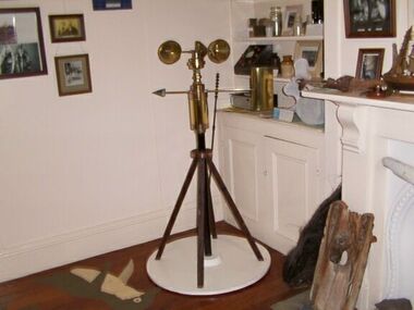 Parks Victoria - Gabo Island Lightstation
Anemometer
... The anemometer, a portable device that manually measures wind speed, was a necessary instrument once common to all weather stations. The arms are attached to a vertical rod and as the wind blows, the cups rotate, making the rod spin. ...The anemometer, a portable device that manually measures wind speed, was a necessary instrument once common to all weather stations. The arms are attached to a vertical rod and as the wind blows, the cups rotate, making the rod spin. ...This device was used to measure surface wind speed and direction. This anemometer was located on a concrete pad outside room 2.15 on a steel pole. The pole was considered unsafe and the anemometer was relocated to it's current position. When lowering the pole it fell over and was badly damaged. The Bureau of Meteorology donated it to the museum. It was then repaired and restored. The central pole on which it is mounted is galvanised iron pipe painted black. The anemometer, a portable device that manually measures wind speed, was a necessary instrument once common to all weather stations. The arms are attached to a vertical rod and as the wind blows, the cups rotate, making the rod spin. The stronger the wind blows, the faster the rod spins. The anemometer counts the number of rotations, or turns, which is used to calculate wind speed, surface wind and direction. They were designed to be durable to withstand the corrosive environment and strong winds expected at coastal sites such as those at Gabo Island. Anemometers existed in the nineteenth century and their design was improved by various experts including John Robinson in 1846, John Patterson in 1926, Brevoort and Joiner in 1935 and Derek Watson in 1991 who added wind direction measurement to its functions. This example was made for the Bureau of Meteorology by the Melbourne instrument company, Synchrotac, which became registered and incorporated on 26 July 1966. It is now displayed inside the building. A good example of its kind, the anemometer has first level contributory significance for its historic value and provenance to the lightstation.Anemometer and tripod stand. Three cupped brass discs on rotating arms fixed to turned brass cylinder shaped shaft. Beneath discs is a lead directional wind arrow attached to a rotating arm. A wooden three legged stand with central supporting pole of black painted hardwood and attached to a white painted marine ply circular base.Under wind cups: " SYNCHROTAC / MELB. / ser.no.70/372 / MADE IN AUSTRALIA." Above wind direction arrow: "C.OF.APT..../ SYNCHROTAC / MELB ? MADE IN AUSTRALIA / ser.no.70/372" -
 Melbourne Tram Museum
Photograph - VR tram 33 at St Kilda Station, K J Magor
... Station...George Hotel...weather...The photograph shows a crowded VR tram 33 waiting to depart St Kilda Railway Station with weather blinds and off-side running board raised, showing destination Middle Brighton. ...Melbourne Tram Museum 8 Wallen Road Hawthorn melbourne The photograph shows a crowded VR tram 33 waiting to depart St Kilda Railway Station with weather blinds and off-side running board raised, showing destination Middle Brighton. ...The photograph shows a crowded VR tram 33 waiting to depart St Kilda Railway Station with weather blinds and off-side running board raised, showing destination Middle Brighton. The George Hotel can be seen in the background.Yields information about St Kilda Railway Station and VR 33Black and white photograph with note on the rear.In ink on the rear " 73 Ken Magor Neg No. Ref per RS"vr tram, st kilda railway station, george hotel, weather blinds, running board, middle brighton, tram 33 -
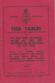 Warrnambool and District Historical Society Inc.
Booklet, Tide Tables, For the year 1976
... weather such as wind, cloud and sea descriptions. These booklets were a useful reference for fishermen and those involved in boating along the coast of Victoria. They are published in digital form today. Sold at Stan McPhee Sports store Liebig St Warrnambool Vic showing local tides. tide table warrnambool tide table 1976 southern victorian tides Booksellers stamp: ink. blue Stan McPhee Sports, green Liebig St Vic. red ...2953. 6717/75. C.H. Rixon, Government Printer, Melbourne. 51st Edition. Recommended price $3.00. Tables for Sunrise, Sunset/moonrise, moonset and transits at Port Phillip Heads & differences for other Victorian and Tasmanian Lighthouse stations ...Yearly publication showing predicted heights in metres for Port Phillip Heads, Williamstown, Portland and Stony Point (Westernport) and tidal differences for other Ports.This booklet provides tide and port information for the coastline of Victoria for the year 1976. It also has information on other aspects of weather such as wind, cloud and sea descriptions. These booklets were a useful reference for fishermen and those involved in boating along the coast of Victoria. They are published in digital form today.Sold at Stan McPhee Sports store Liebig St Warrnambool Vic showing local tides. Red card wrap around cover. 92 cream coloured pages held with 2 staples. Black print. Ports and harbour seal on the frontBooksellers stamp: ink. blue Stan McPhee Sports, green Liebig St Vic. red ...2953. 6717/75. C.H. Rixon, Government Printer, Melbourne. 51st Edition. Recommended price $3.00. Tables for Sunrise, Sunset/moonrise, moonset and transits at Port Phillip Heads & differences for other Victorian and Tasmanian Lighthouse stations.tide table, warrnambool tide table 1976, southern victorian tides -
 Warrnambool and District Historical Society Inc.
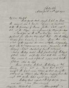
Letter, E H Macartney to Augustus Bostock, 1900
... This is one of a number of letters from E H Macartney of Delatite station to Augustus Bostock, with this one relating weather, details, sheep and the building of a sheep dip. ...This is one of a number of letters from E H Macartney of Delatite station to Augustus Bostock, with this one relating weather, details, sheep and the building of a sheep dip. ...Augustus Bostock was the 9th child of Robert & Rachael Bostock of Vaucluse Epping Forest, Van Diemen’s Land. He was only 4 years old when his mother died. He was inspired by his father to seek his fortune in the Western District of Victoria. He arrived around 1850. He married Margaret Aitkin in July 1865. Augustus owned several properties in the district and leased others. He sat on the court of Warrnambool, Mortlake or Hexham as required. He resided at Marramook in Hawkesdale and later moved to Vaucluse in Hopetoun Road Warrnambool, where he died in 1920 at the age of 87. He was involved in many aspects of life in the Western District, racing, cricket, and social activities to name a few. This is one of a number of letters from E H Macartney of Delatite station to Augustus Bostock, with this one relating weather, details, sheep and the building of a sheep dip. This is one of a number of documents which relate to the Bostock family who were one of the most important pioneering families of the Western District. They owned and leased various properties around Warrnambool and were involved in many aspects of social and business life. This letter relates farming and social details at the timeCream lined paper with large margin on left side. Written in black ink.E H Macartney, Delatite Mansfield , 25th Sept 1900warrnambool, bostock, augustus bostock, -
 Kiewa Valley Historical Society
Photographs and copies of photographs of the pack horses and early horsemen who transported supplies to outposts in the Bogong High Plains, via cattle tracks before access roads were made
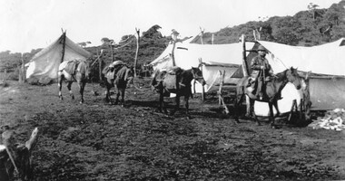
... weather and living conditions of bush camping, often arriving in their city clothes ready for work. The tent city at Bogong was destroyed by bush fires in 1939 after which an access road was built from Mt Beauty to transport building materials for more permanent dwellings for workmen. Pack horses continued to be used for transporting goods etc. to workers further up the mountain. Without the work of horsemen and their pack horses providing supplies and communications for outlying outposts, surveying and early planning for the Kiewa Valley Hydro Electric scheme could not have gone ahead and the dams and power stations ...In the mid to late 1930’s survey outposts were established to plot the early stages of the Kiewa Hydro Electric System for the SECV in the Bogong High Plains. Before any roads were built, the old cattleman’s tracks were used with packhorses to deliver supplies, wages and mail and collect timesheets and correspondence from the workmen and dam builders living in canvas tents and at the outlying survey posts. The trip up the mountain was long and hard and dangerous for both horse and man Most of the men of the survey teams were not bush-men and were often ill equipped for the harsh weather and living conditions of bush camping, often arriving in their city clothes ready for work. The tent city at Bogong was destroyed by bush fires in 1939 after which an access road was built from Mt Beauty to transport building materials for more permanent dwellings for workmen. Pack horses continued to be used for transporting goods etc. to workers further up the mountain.Without the work of horsemen and their pack horses providing supplies and communications for outlying outposts, surveying and early planning for the Kiewa Valley Hydro Electric scheme could not have gone ahead and the dams and power stations which support the system could not have been constructed. The Hydro-electric scheme, and the workers who planned and built it play a major part in the early history of the Kiewa Valley and many original families still remain living, or have ties with the local area.: Set of 21 black and white photographs and copies of photographs depicting the pack horses and the men who handled them, transporting supplies and correspondence to the outlying camps and survey posts in the Bogong High Plains, via the rough cattlemen’s tracks. Photographs also show the early tent camps of the workers. Some photos mounted on A4 white paper. Some photos enlarged to A3 poster size for display1. Handwritten on back – Max Lawrence 2. -8 No inscriptions 9. Handwritten on back- Packing in supplies for early workers of the Kiewa Hydro scheme. There were no roads in the early days of the scheme 10. Printed on bottom of photo- Roper’s cattle on road below Howman’s Gap 11. Handwritten on back – Roper’s et al about to leave for the high plains 12. Printed under photo- Syd Ryder at the Pretty Valley Cut-Out (JBR) 13-16. No markings 17. Printed under photo- Gwen Talbot visits the Camp area. 1937 18. Handwritten on back- 14/1 Barbara Talbot 19. No markings 20-21. No markings 22. Printed under photo- STATE ELECTRICITY COMMISSION OF VICTORIA. Date: 15-3-45 Time: 8.0pm No: K 1838 Kiewa Hydro-Electric Works, Investigations 1944-1945 – Survey Camp at Young’s Hut pack horses; bogong high plains; survey posts; supplies delivery -
 Kiewa Valley Historical Society
Photograph - Folder of Photographs – Photocopied set of 10 black and white photographs (pages 29 - 38) from the display folder put together by KVHS to document life on the Kiewa Valley Hydro-electric Scheme
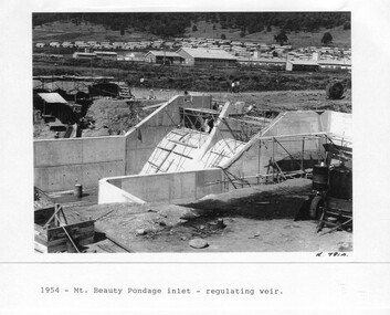
... Large A3 size spiral bound display folder containing 21 pages of photocopied black and white photographs of various aspects of the early days of the Kiewa Valley Hydro-electric scheme including equipment, various work sites and photographs of workers and their families. 1-Mt Beauty Pondage inlet-Regulating weir 2-Langfords Gap Basalt Hill-Tunnel in quarry face.3-Rocky Valley Camp-from Engineering Office 4-Basalt Hill tunnel portal 5-No 1 Pressure Shaft Works Bench 6-No 1 Power Station 7-Overturned haulage wagons on the side of an embankment 8- Group of workers dressed in wet weather gear inside a tunnel 9-Workmen and vehicle in tunnel 10-Howman’s Gap campsite at 4,150 feet ...Mount Beauty, and to a lesser extent Bogong, are among these places. secv; kiewa hydro electric scheme; mt beauty; bogong; construction area 1-1954 – Mt Beauty Pondage inlet – Regulating weir Page number 29 2-28/10/54 – Langfords Gap Basalt Hill – Tunnel in quarry face K7860 Page number 30 3-STATE ELECTRICITY COMMISSION OF VICTORIA Date: 17.8.55 Time: No K8132 Kiewa Hydro Electric Works ROCKY VALLEY CAMP – FROM ENGINEERING OFFICE Page number 31 4-28/10/54 – Basalt Hill tunnel portal K7859 Page number 32 5-No.1 Pressure Shaft Works Bench 5.7.56 Page number 33 6- No. 1 Power Station 26.4.59 Page number 34 7- No markings Page number 35 8-No markings (Wooden board on ground printed with - POLAR A.N.GELATINE DYNAMITE “75” DE 28.8.40) Page number 36 9-No markings Page number 37 10-Howman’s Gap campsite at 4,150 feet Page number 38 Large A3 size spiral bound display folder containing 21 pages of photocopied black and white photographs of various aspects of the early days of the Kiewa Valley Hydro-electric scheme including equipment, various work sites and photographs of workers and their families. 1-Mt Beauty Pondage inlet-Regulating weir 2-Langfords Gap Basalt Hill-Tunnel in quarry face.3-Rocky Valley Camp-from Engineering Office 4-Basalt Hill tunnel portal 5-No 1 Pressure Shaft Works Bench 6-No 1 Power Station 7-Overturned haulage wagons on the side of an embankment 8- Group of workers dressed in wet weather gear inside a tunnel 9-Workmen and vehicle in tunnel 10-Howman’s Gap campsite at 4,150 feet Photograph Folder of Photographs – Photocopied set of 10 black and white photographs (pages 29 - 38) from the display folder put together by KVHS to document life on the Kiewa Valley Hydro-electric Scheme ...Although the Kiewa Hydro-Electric Scheme was first proposed in 1911, construction did not commence until 1938. As part of the push to cut electricity costs and diversify supply, the Victorian Government (circa 1930) initiated the conversion from primarily brown coal supply to hydro – electricity. Field investigations during the 1940’s resulted in a new proposal for a scheme that had more than double the capacity of the 1938 scheme. The Kiewa Hydroelectric Scheme became the largest scheme of its kind in the State Of Victoria and the second largest scheme in Australia. The number of personnel involved in the planning and construction of the scheme increased dramatically. During the late 1940’s, most activity centred around the construction of the West Kiewa Power Station, Rocky Valley Reservoir, McKay Creek Power Station and the Bogong Creek Aqueduct.A common thread across all the larger hydro scheme constructions was the need for workers, both qualified and unqualified who came from around the world seeking a new life for themselves and their families. New accommodation and facilities were required for the army of workers engaged in construction in often remote and wild areas. The SEC had a high demand for timber, and set up the first of a number of sawmills at Bogong Creek in 1939 and set up the first hardwood logging in the headwaters of the Kiewa River. These new ‘towns’ such as Mt Beauty and Bogong, survived, serving the needs of operational personnel and their families, and expanding with growth of new industries. Mount Beauty, and to a lesser extent Bogong, are among these places. Large A3 size spiral bound display folder containing 21 pages of photocopied black and white photographs of various aspects of the early days of the Kiewa Valley Hydro-electric scheme including equipment, various work sites and photographs of workers and their families. 1-Mt Beauty Pondage inlet-Regulating weir 2-Langfords Gap Basalt Hill-Tunnel in quarry face.3-Rocky Valley Camp-from Engineering Office 4-Basalt Hill tunnel portal 5-No 1 Pressure Shaft Works Bench 6-No 1 Power Station 7-Overturned haulage wagons on the side of an embankment 8- Group of workers dressed in wet weather gear inside a tunnel 9-Workmen and vehicle in tunnel 10-Howman’s Gap campsite at 4,150 feet 1-1954 – Mt Beauty Pondage inlet – Regulating weir Page number 29 2-28/10/54 – Langfords Gap Basalt Hill – Tunnel in quarry face K7860 Page number 30 3-STATE ELECTRICITY COMMISSION OF VICTORIA Date: 17.8.55 Time: No K8132 Kiewa Hydro Electric Works ROCKY VALLEY CAMP – FROM ENGINEERING OFFICE Page number 31 4-28/10/54 – Basalt Hill tunnel portal K7859 Page number 32 5-No.1 Pressure Shaft Works Bench 5.7.56 Page number 33 6- No. 1 Power Station 26.4.59 Page number 34 7- No markings Page number 35 8-No markings (Wooden board on ground printed with - POLAR A.N.GELATINE DYNAMITE “75” DE 28.8.40) Page number 36 9-No markings Page number 37 10-Howman’s Gap campsite at 4,150 feet Page number 38 secv; kiewa hydro electric scheme; mt beauty; bogong; construction area -
 Kiewa Valley Historical Society
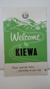
Leaflet - Kiewa, Welcome to Kiewa
... stations, dams, tunnels and was becoming a popular tourist destination with Falls Creek Ski field within its boundaries. This leaflet was published by the SECV to ensure all visitors to the Kiewa Hydro Electric Scheme were made aware of safety measures with regard to their driving and to bush fires. These were necessary as the area was unique with driving on mountainous roads, changeable and extreme weather ...The State Electricity Commission of Victoria constructed the Kiewa Hydro Electric Scheme from 1938 to 1961. The Scheme included three power stations, dams, tunnels and was becoming a popular tourist destination with Falls Creek Ski field within its boundaries.This leaflet was published by the SECV to ensure all visitors to the Kiewa Hydro Electric Scheme were made aware of safety measures with regard to their driving and to bush fires. These were necessary as the area was unique with driving on mountainous roads, changeable and extreme weather and the threat of bush fires. The gatehouse existed during construction, when the SECV was in charge, as a restriction to entry to the Scheme for SECV workers and those with permission to enter. The SECV controlled the area so in case of accident, the SECV was the body to contact not eg. the police.Small white and green leaflet made from one sheet of glossy paper and folded in half. Front cover has the title in the middle, the SECV emblem at the centre top and across the bottom is a message to read the inside pages which are safety messages for driving and bush fires. The back cover has a RACV road map of Kiewa and its 'works' including the Gatehouse which was the entrance to the scheme.The map also has an insert of the main roads & nearby cities. state electricity commission of victoria; kiewa hydro electric scheme; gatehouse; safety rules; kiewa -
 Kiewa Valley Historical Society
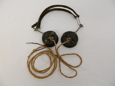
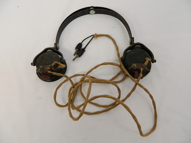
Headphones - Transmitter radio, c1924
... stations on the High Plains far above the snow-line. In operation, the service is similar to a normal telephone system but dispenses with the physical connection of wires and poles between the main terminals. Historical: This type of headphone was recommended for amateurs. It may have been used by operators on the Switchboard at Bogong or one of the construction camps on the Kiewa Hydro Electric Scheme. The S.E.C.V installed this unique system of communication to operate their branches especially at Bogong and beyond where the distance was great and often limited by the terrain and weather ...Radio Telephone was minuted during the war. It was approved in 1944 for State Electricity Commission of Victoria use only. It was completed by the end of 1946. Used by the State Electricity Commission of Victoria at Bogong during the construction of the Kiewa Hydro Electric Scheme to connect with head office in Melbourne. It allows one conversation at a time using traffic controls in an unusual system of radio telephone providing communication. At the time it was unique in Australia and installed by the S.E.C.V. technicians. It provided an unattended shortwave radio link between two ordinary telephone switchboards, connecting any of the S.E.C.V.'s internal lines with the telephone system at Bogong and the construction camps beyond. From Bogong, radio phones connect to the outpost stations on the High Plains far above the snow-line. In operation, the service is similar to a normal telephone system but dispenses with the physical connection of wires and poles between the main terminals. Historical: This type of headphone was recommended for amateurs. It may have been used by operators on the Switchboard at Bogong or one of the construction camps on the Kiewa Hydro Electric Scheme. The S.E.C.V installed this unique system of communication to operate their branches especially at Bogong and beyond where the distance was great and often limited by the terrain and weather.Used for a transmitter radio or Radio Telephone as installed by the State Electricity Commission of Victoria 2 round ear pieces. Outside of ear piece has the brand inscribed and 3 points where wires are attached. On opposite edges of the earpieces a metal piece with handle is attached from which the 2 earpieces are connected with curved wire covered by leather to fit on top of the head. Each earpiece has a cord hanging from the middle attachment (on the outside) which joins and then continues as one to 2 metal pins that would fit into holes in the switchboard. On outside of each earpiece - 'Brunet & Co. / Paris' in oval 'Type f' underneathradio telephone. ear phones. head phones.communications.state electricity commission of victoria. kiewa hydro electric scheme. bogong. switchboards. -
 Kiewa Valley Historical Society
Headphone - Transmitter radio
... stations on the High Plains far above the snow-line. In operation, the service is similar to a normal telephone system but dispenses with the physical connection of wires and poles between the main terminals. Historical: This type of headphone was used by operators on the switchboards at Bogong, Mt Beauty or on one of the construction camps on the Kiewa Hydro Electric Scheme. The S.E.C.V. installed this unique system of communication to operate their branches especially at Bogong and beyond where the distance was great and often limited by the weather ...Radio Telephone: Minuted during the war. It was approved in 1944 for State Electricity Commission of Victoria use only. It was completed by the end of 1946. Used by the State Electricity Commission of Victoria at Bogong during the construction of the Kiewa Hydro Electric Scheme to connect with head office in Melbourne. It allows one conversation at a time using traffic controls in an unusual system of radio telephone providing communication. At the time it was unique in Australia and installed by the S.E.C.V. technicians. It provided an unattended shortwave radio link between two ordinary telephone switchboards, connecting any of the S.E.C.V.'s internal lines with the telephone system at Bogong and the construction camps beyond. From Bogong, radio phones connect to the outpost stations on the High Plains far above the snow-line. In operation, the service is similar to a normal telephone system but dispenses with the physical connection of wires and poles between the main terminals.Historical: This type of headphone was used by operators on the switchboards at Bogong, Mt Beauty or on one of the construction camps on the Kiewa Hydro Electric Scheme. The S.E.C.V. installed this unique system of communication to operate their branches especially at Bogong and beyond where the distance was great and often limited by the weather and terrain.Used for a transmitter radio or Radio Telephone as installed by the State Electricity Commission of Victoria 2 round ear pieces. Outside of each ear piece has the brand inscribed, 4 screws and 1 small piece of metal. The metal has 2 screws attaching the the cord that goes to the 'switchboard'. On opposite edges of the earpieces is a thick metal piece that curves up to which the curved metal headpiece is attached and therefore connecting the earpieces. Each earpiece has a cord hanging from the small metal piece of earphone. This cord joins and then continues as one to the end where there are 2 metal pins coming out of the soft cover.'C-LR ST & C of Sydney'radio telephone. ear phones. headphones. communications. state electricity commission of victoria. kiewa hydro electric scheme. bogong. switchboards. -
 Bendigo Military Museum
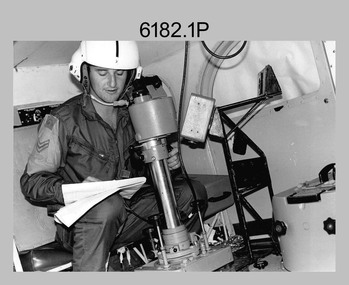
Photograph - Royal Australian Survey Corps Aerial Surveys, c1980
... station on aerial photography. Introduced in 1974–1975, the Magnavox AN/PRR-14 portable Doppler satellite (US Navy Navigation Satellite System – TRANSIT) receivers and computing system provided independent three-dimensional point positions anywhere in the world, anytime, in any weather accurate to about 1.5metres with precise satellite ephemerides. ...station on aerial photography. Introduced in 1974–1975, the Magnavox AN/PRR-14 portable Doppler satellite (US Navy Navigation Satellite System – TRANSIT) receivers and computing system provided independent three-dimensional point positions anywhere in the world, anytime, in any weather accurate to about 1.5metres with precise satellite ephemerides. ...This is a set of nine photographs of technicians from the Royal Australian Survey Corps operating aerial surveys equipment c1980s. In photo .1P, CPL Steve Gloster was operating a RC10 air survey camera mounted in an Australian Army Pilatus Porter aircraft. The Wild RC10 super wide-angle air survey cameras were first introduced in 1971, were equipped with virtual distortion free lenses for supplementary, spot and special photography. In photo .2P, Roger Rees was operating Air Profile Recorder (APR) equipment. it was possibly taken during OP NERVOSE 84, sometime between June – August 1984 when based in Ngukurr, Northern Territory. The APR was operated at this time in unison with an RC10 camera. In 1963 the Royal Australian Survey Corps introduced the radar airborne profile recorder (Canadian Applied Research Ltd, Mark V, Airborne Profiler Recorder) was introduced for 1:100,000 mapping to replace terrain heighting by aneroid barometry. Later in 1974-1975, the Australian developed WREMAPS II airborne laser terrain profile recorder was introduced. In photo .3P, Neil Jones appears at the door of Airsearch Beechcraft Queen Air aircraft, Registration / Serial VH-MWX. This aircraft was typically used by RA Svy on air survey operations flying mission with Aerodist, APR and RC10 camera equipment. The Australian Army’s Pilatus Porter (short take-off and landing turbo propeller) was also equipped with a Wild RC10 aerial mapping camera for identification photography. The Pilatus Porter was also used on RA Svy’s map field checking operations. Photo .9P was taken at a survey station at an unknown location. In this photo an Australian Army Kiowa Light Observation Helicopter (LOH) is supporting a field survey party undertaking Magnavox AN/PRR-14 portable Doppler satellite observations. The satellite receiver’s antenna is plumbed over the survey ground mark surrounded by white plastic panels. The panels were used to identify the survey station on aerial photography. Introduced in 1974–1975, the Magnavox AN/PRR-14 portable Doppler satellite (US Navy Navigation Satellite System – TRANSIT) receivers and computing system provided independent three-dimensional point positions anywhere in the world, anytime, in any weather accurate to about 1.5metres with precise satellite ephemerides. The Bell OH-58 Kiowa LOH was a family of military helicopters used for observation, utility, and direct fire support. It was identified by RA Svy in the mid-1970s that considerable time was lost in replacing unserviceable remote equipment by road. Therefore Aerodist operations (pre-dating satellite receiver operations) were fully supported by Army’s Kiowa LOH aircraft. This is a set of nine photographs of technicians from the Royal Australian Survey Corps operating aerial surveys equipment c1980s. .1P to .3P, .5P to .9P - Colour and black and white photos on photographic paper and scanned at 300 dpi. .4P - Colour photo on 35mm slide film and scanned at 96 dpi. .1) & .2) - Photo, black & white, c1980s, CPL Steve Gloster operating an RC10 air camera. .3) - Photo, colour, 1984, Roger Rees operating Air Profile Recorder (APR) equipment. .4) - Photo, colour, c1980s, Neil Jones at the door of an Airsearch Beechcraft Queen Air aircraft, typically used by RA Svy on air survey operations. .5) - Photo, colour, c1980s. A Beechcraft King Air aircraft, also used by RA Svy on air survey operations. .6) - Photo, colour, c1980s. An Australian Army Pilatus Porter, used by RA Svy on air survey and map field checking operations. SGT Peter Mustart is possibly in the foreground. .7) to .8) - Photo, colour, c1980s. An Australian Army Pilatus Porter and unidentified personnel, used by RA Svy on air survey and map field checking operations. .9) - Photo, colour, c1980s. An Australian Army Kiowa helicopter supporting a field survey party undertaking Magnavox AN/PRR-14 portable Doppler satellite observations. There are biro marks on photos .4P to .9Proyal australian survey corps, rasvy, army survey regiment, asr, fortuna, aerial surveys -
 Bendigo Military Museum
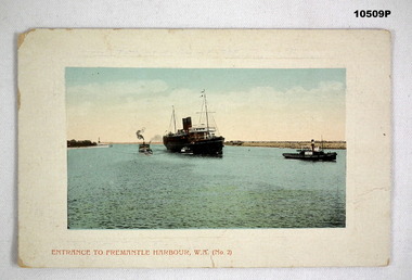
Postcard - PHOTOGRAPHIC POSTCARD, P. Falk & Co Ltd, Unknown
... Station, W.A” “Dear Miss McIntyre. I hope you are quite well. I should have written to you before, but I have been dreadfully lazy. i do not know how I am going to start work again. We have had dreadful weather...Station, W.A” “Dear Miss McIntyre. I hope you are quite well. I should have written to you before, but I have been dreadfully lazy. i do not know how I am going to start work again. We have had dreadful weather ...There is a Post Office stamp on top right side. Fees in Australasia and Great Britain 1 penny. Other places 1 1/2 pennies.A colourised postcard depicting a two funnel ship coming into Fremantle Harbour. The ship has 2 masts, the bridge is white. There is a tug boat in front of the ship. There is a small vessel against the starboard side. Two smaller vessels are between the ship and shore. All appear to be coal fired. The actual picture has a white border of approx 15mm size.Written on the back is:- “Date Sep 9th. Trafalgar Railway Station, W.A” “Dear Miss McIntyre. I hope you are quite well. I should have written to you before, but I have been dreadfully lazy. i do not know how I am going to start work again. We have had dreadful weather, nothing but wind and dust, I would much rather live in Melbourne. Love to all from Mat”postcard, fremantle wa -
 Victoria Police Museum
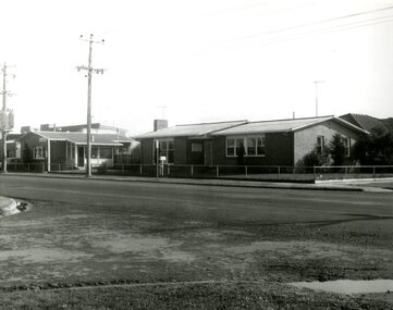
Police Stations (Altona)
... The original police station was in a small room attached to the front of a 5-roomed weather-board dwelling with an iron roof on land measuring 66' x 165'. ...The original police station was in a small room attached to the front of a 5-roomed weather-board dwelling with an iron roof on land measuring 66' x 165'. ...Altona is a suburb of Melbourne, 13 km south-west of Melbourne's CBD and located within the City of Hobsons Bay Altona Police Station opened as a temporary police station in 1919 in the Melbourne District. It was on the corner Sargood and Blyth Streets. It was staffed by one 1st Constable. The original police station was in a small room attached to the front of a 5-roomed weather-board dwelling with an iron roof on land measuring 66' x 165'. There was also a kitchen, vestibule, wash-house, office, one W.C. and a lock-up. In 1929 it became part of the Bourke District. On 31 March 1958 it moved into newly built government premises at 51-53 Blyth Street, on the corner of Bent Street. The building consisted of a cream brick veneer police residence and police station with cell. Staff was increased to a Sergeant in Charge and 3 Constables. A new police station was opened in Altona North on 7th October 1979. The Altona Police Station remained as a sub-station for a few a short time until the building was sold. July 2019 - a new police station is being constructed at 1 Galvin Street, Altona. Galvin Street was names after S/C Michael Arthur Galvin, 3651, who was appointed on 5 Jan 1886 and resigned on 4 Dec 1913. He was Werribee Shire President 1926-1927 and 1940-1941 8 black and white photos of new police station, 1963police stations; altona police station -
 Victoria Police Museum
Police Stations (Apollo Bay)
... In 1930 the police station was located to 29 Nelson Street. It was a seven-roomed weather-board dwelling on three-quarters of an acre of land. ...In 1930 the police station was located to 29 Nelson Street. It was a seven-roomed weather-board dwelling on three-quarters of an acre of land. ...Apollo Bay is a coastal town in southwestern Victoria. It is situated on the eastern side of Cape Otway, along the edge of the Barham River and on the Great Ocean Road, in the Colac Otway Shire. The original township was surveyed in 1853 and named Middleton. In 1881 the town was renamed Krambruk which was changed to Apollo Bay in 1898. The Krambruk Police Station was opened on 7 March 1888 in the Southern District on land opposite the site of the current Mechanics' Institute and changed its name to the Apollo Bay Police Station on 1 September 1990. It came under the Barwon District in 1948 and "Lima" Western District from 4 March 1990. In 1930 the police station was located to 29 Nelson Street. It was a seven-roomed weather-board dwelling on three-quarters of an acre of land. It consisted of six rooms of pine, lined and painted; one pantry; one bathroom and wash-house; one hall; one office and one W.C.. There was stabling for one horse and one cell for prisoners. It was staffed by one Mounted Constable. In the early 1970s land was acquired at 31 Nelson Street and a new police station was constructed. This was a three-roomed brick building with a cell block at the rear. By the time it closed in 2005 it had been extended twice. On 17 November 2006 the current Apollo Bay Police Station opened in its current location at 35a Nelson Street, on the corner of Cartwight Street). Outside the peak summer season, the station is open 16 hours per day and staffed by one sergeant and five other members. 3 black & white photos and 2 coloured photospolice stations; apollo bay police station -
 Bendigo Military Museum
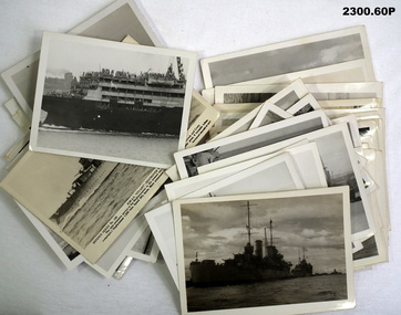
Photograph - PHOTOGRAPHS, NAVY WW2, c.WWII
... 1941 .14) HMS Carthage .15) Pilot station at Colombo .16) Aquitania .17) Ajax on patrol with Hobart and battle fleet .18) Hobart rolling in the Bight .19) HMS Gnat (river gun boat) hit by torpedo at Tobruk .20) - .21) Mauritania .22) Italian cruiser sunk by HMAS Sydney .23) Greek destroyer .24) Memorial of Mohomed Pasha Alexandria. Presented by Musso .25) Searchlight at Alexandria .26) Hobart pile driving in heavy weather...1941 .14) HMS Carthage .15) Pilot station at Colombo .16) Aquitania .17) Ajax on patrol with Hobart and battle fleet .18) Hobart rolling in the Bight .19) HMS Gnat (river gun boat) hit by torpedo at Tobruk .20) - .21) Mauritania .22) Italian cruiser sunk by HMAS Sydney .23) Greek destroyer .24) Memorial of Mohomed Pasha Alexandria. Presented by Musso .25) Searchlight at Alexandria .26) Hobart pile driving in heavy weather ...Photographs collected by Earnest Albert Simmons W/2129 Royal Australian Navy. Enlisted 30 June 1941 and discharged 14 October 1946 with the rank of Leading Stoker. Posting at discharge was HMAS Lonsdale..1) Ship .2) Submarine conning tower .3) Ship .4) Hospital ship .5) Ship at anchor .6) Launch at ships side .7) Ships at anchor .8) Sunken ship .9) Ship .10) Group on launch .11) Ship firing a broadside .12) Wooden sailing vessel .13) Ship .14) Ship .15) Pilot station .16) Ship .17) Ship .18) Ship.s deck and biplane .19) Partially sunken ship .20) Two ships .21) Ship .22) Ship - damaged .23) Ship .24) Statue and colonade .25) Searchlights .26) Ships deck at sea .27) Aircraft .28) Ship .29) Ship .30) Troop ship .31) Swimmers at ships side .32) Ship .33) Ship .34) Ship deck at sea .35) Ship .36) Submarine .37) Ship .38) Ship .39) Ship .40) Two ships at sea .41) Ship .42) Aircraft carrier .43) Ships symbol .44) Sketch of Berbera .45) Sketch of biplanes .46) Boat at pier .47) Tug boat .48) Ship .49) Ship at wharf .50) Ships at wharf .51) Aircraft carrier .52) Ship .53) Ship at wharf .54) Ships at wharf .55) Ship .56) Two ships .57) Tug boat .58) Diagram comparing the size of two ships .59) Ship sailing past lighthouse .60) Postcard HMAS "Stuart". .1) Hobart and Glascow at Colombo .2) British submarine returning to Alexandria after claiming a victory - note Skull and X Bones .3) HMS Glascow at Colombo .4) Ex Italian hospital ship taken over by British. RAMB II .5) HMS Exeter .6) The landing party returning .7) Part fleet at Colombo .8) British ammunition ship sunk by sabotage in Alex Harbour .9) HMS Exeter .10) On the approach of the island. Note twin Lewis guns .11) HMS Ajax bombarding Bardia .12) A native boat used along coasts and Indian Ocean .13) RMS Georgie refoated at Pt? 1941 .14) HMS Carthage .15) Pilot station at Colombo .16) Aquitania .17) Ajax on patrol with Hobart and battle fleet .18) Hobart rolling in the Bight .19) HMS Gnat (river gun boat) hit by torpedo at Tobruk .20) - .21) Mauritania .22) Italian cruiser sunk by HMAS Sydney .23) Greek destroyer .24) Memorial of Mohomed Pasha Alexandria. Presented by Musso .25) Searchlight at Alexandria .26) Hobart pile driving in heavy weather .27) Lockheed Hudson dive bombing .28) - .29) HMS Galatea? x 1 turret at stern .30) Troops on Aquitania .31) Boys swimming in the middle lakes at Ismalia in the centre of Sues Canal .32) A water NG ? .33) - .34) Hobart striking heavy weather .35) HMS Jupiter .36) British submarine entering Alex .37) Queen Mary .38) Queen Elizabeth .39) Nieuw Amsterdam .40) - .41) Achilles .42) HMS Aircraft carrier - Illustrious .43) Symbol of Hobart's Pom-Pom .44) - .45) - .46) - .47) - .48) Mohoja and Oronties .49) Mohoja .50) - .51) - .52) HMAS Murchison 1954 .53) Strathmore .54) - .55) - .56 - .57 - .58) HMAS Vendetta .59) HMAS Cowra .60) - photographs, ran, hmas -
 Ballarat Clarendon College
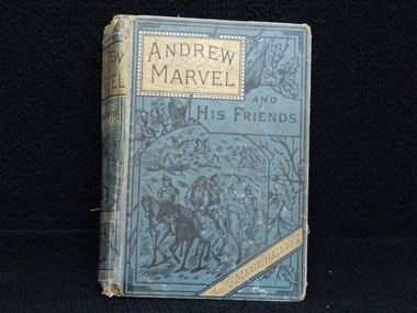
Book, Andrew Marvel and his friends, 1884
... Station in Nhill. Presbyterian educators placed great value on a classical education matched with diligence in study. Book prizes were highly regarded and academic success admired. In the school’s early years prizes were ordered direct from London and had the school crest embossed in gold on the front or back cover. Many of the prizes given in early years were returned to the school to equip the Weatherly ...This book was awarded to Mary Isabella Macdonald for second prize in Third English History in 1886. Mary entered Clarendon Ladies' College in 1885. On the original register it states that Mary was enrolled by her father named William who's occupation is noted as "Squatter" and who resided at Nhill Station in Nhill.Presbyterian educators placed great value on a classical education matched with diligence in study. Book prizes were highly regarded and academic success admired. In the school’s early years prizes were ordered direct from London and had the school crest embossed in gold on the front or back cover. Many of the prizes given in early years were returned to the school to equip the Weatherly Library when it opened in 1936.Bound in green fabric with ornate decorative illustration on cover and gilt lettering. Detached spine, black and white illustrated, 469 p. Book plate inside front cover: CLARENDON LADIES' COLLEGE./ BALLARAT./ Second PRIZE./ III rd English History/ AWARDED TO/ Mary Isabella Macdonald/ 19 th December, 1886.mary-isabella-macdonald, clarendon-ladies' -college, 1886, william-macdonald.