Showing 1113 items matching "world map"
-
 Flagstaff Hill Maritime Museum and Village
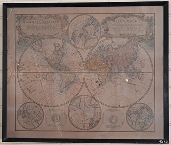
Map - World Map, Mappe Monde [Medieval Map of the World], 1910
... World Map...Mappe Monde [Medieval Map of the World]......World Map...Map behind glass in dark brown wooden frame on beige paper. The Coloured hand drawn line drawings show different hemispheres of the known world in the mid-18th century. ..."PLANIGLOBIL TERRESTRIS" "MDCCXXXXVI" [1746] "MAPPE_MONDE" [Medieval Map of the World] "LEISURE ARTS LTD" "Printed in England"...Mappe Monde [Medieval Map of the World] Map World Map ...This map from the mid-18th century doesn't include the finer details of land and sea masses that we know today. The map was produced by German cartographer and publisher, Johann Baptist Homann (1663-1724) and published in 1746, after his death. Earlier versions were published, such as 1707 and 1716. The date can be calculated from the Roman numerals on the top left text area. This print of a map is significant for its connection with early world explorers. A comparison of maps over the centuries shows the progression of navigational technology, the countries who claimed the land they explored. The naming of even some Australian locations shows who had already made their mark on Australia in the early 18th century. The print shows the fine details included by the cartographer and the beauty included that makes it attractive and interesting even today. The map is also significant for its connection with German cartographer, Johann Baptist Homann, whose Homann publishing company was renewed in Germany for producing high quality maps and atlases. Map behind glass in dark brown wooden frame on beige paper. The Coloured hand drawn line drawings show different hemispheres of the known world in the mid-18th century. Beautifully drawn figures and decorative embellishments enhance the map. The text on the top right has an explanation of the Figures I, II, III, and IV. This print of the 1746 map was produced in England by Leisure Arts Ltd. "PLANIGLOBIL TERRESTRIS" "MDCCXXXXVI" [1746] "MAPPE_MONDE" [Medieval Map of the World] "LEISURE ARTS LTD" "Printed in England"flagstaff hill, warrnambool, flagstaff hill maritime museum, flagstaff hill maritime village, flagstaff hill maritime museum and village, shipwreck coast, world map, french map, 18th century map, leisure arts ltd, cartography, early exploration, cartographer, johann homann (1663-1724), exploration, naviagtion, 1746 planiglobil terrestris -
 National Wool Museum
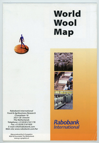
Map - World Wool Map, Rabobank International, c.2002
... World Wool Map...Folded world map showing statistics, images and graphics relating to wool in the 1990's....front: World Wool Map / Rabobank / International / Rabobank International / Food & Agricultural Research / Croeselaan 18 / 3521 CB Utrecht / The Netherlands / Telephone +31 (0) 30 2161178 / Fax +31 (0) 30 2161920 / E-mail: [email protected] / Web-site:www.rabobank.com/far / Map produced by G-O graphics / Wijk bij Duurstede, The Netherlands / www.g-o-graphics.nl...Map World Wool Map Rabobank International ...Part of a collection of books, manuals, photographs, letters and clothing relating to the working life of Stuart Ascough. Stuart's career in the wool industry spanned over 43 years from 1960 to 2003 in various roles including Topmaking Plant Manager at Courtaulds Ltd. in Spennymore, U.K., Operations Manager at Port Phillip Mills in Williamstown Victoria, Marketing Executive, Early Stage Wool Processing at the International Wool Secretariat Melbourne, Australia and General Manager of Victoria Wool Processors Pty. Ltd. in Laverton North, Victoria. Throughout his career Stuart travelled extensively, and in the 1990s worked at many topmaking mills in China on quality improvement projects. He also provided technical advice and training at mills in India, Ukraine, Lithuania, Kyrgyzstan, Russia, Latvia, Byelorussia and other parts of Europe and Asia.Folded world map showing statistics, images and graphics relating to wool in the 1990's.front: World Wool Map / Rabobank / International / Rabobank International / Food & Agricultural Research / Croeselaan 18 / 3521 CB Utrecht / The Netherlands / Telephone +31 (0) 30 2161178 / Fax +31 (0) 30 2161920 / E-mail: [email protected] / Web-site:www.rabobank.com/far / Map produced by G-O graphics / Wijk bij Duurstede, The Netherlands / www.g-o-graphics.nlstuart ascough, international wool secretariat, victoria wool processors, port phillip mills pty ltd, topmaking, career, wool industry, training, technical advice, mills, map -
 Moorabbin Air Museum
Souvenir (item) - Pan Am map of world flights 1980
... Pan Am map of world flights 1980...Pan Am map of world flights 1980...foolscap paper map of world flights...Moorabbin Air Museum Moorabbin Airport 12 First Street Moorabbin melbourne foolscap paper map of world flights Pan Am map of world flights 1980 Souvenir Pan Am map of world flights 1980 ... -
Moorabbin Air Museum
Map (Item) - The World Map - National Geographic Magazine
... The World Map - National Geographic Magazine ...Moorabbin Air Museum Moorabbin Airport 12 First Street Moorabbin melbourne Map The World Map - National Geographic Magazine ... -
Broadmeadows Historical Society & Museum
Map - Map of Australia, John Bartholomew & Son Ltd, Contour- coloured world map series: Australia, c. 1955
... Contour- coloured world map series: Australia...Broadmeadows Historical Society & Museum 21 Pearcedale Parade Broadmeadows melbourne Printed 1955 Quality Map in good condition, can be used for research purposes Australia Map Historical information Education Map of Australia - Colour contoured - printed on cloth, scale 1:5,000,000 Contour- coloured world map series: Australia Map Map of Australia John Bartholomew & Son Ltd Mr. ...Printed 1955Quality Map in good condition, can be used for research purposesMap of Australia - Colour contoured - printed on cloth, scale 1:5,000,000australia, map, historical information, education -
 Lara RSL Sub Branch
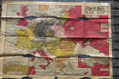
Newspaper - The Sun Newspaper Dated 5/8/1944 -specia - World War 2 Europe Map and History Of World War 2 and Nazi Tide Flows and Ebbs Across Europe, THe Sun Newspaper Dated 5/8//1944 - Special War Maps
... The Sun Newspaper Dated 5/8/1944 -specia - World War 2 Europe Map and History Of World War 2 and Nazi Tide Flows and Ebbs Across Europe...world war 2 europe map and hisytory of world war 2 and nazi tide flows and ebbs across europe...Local Newspaper Dated 5/8/1944 - Special World War 2 Maps... World War 2 Europe Map and History Of World War 2 and Nazi Tide Flows and Ebbs Across Europe...Lara RSL Sub Branch McClelland Ave Lara The Sun Newspaper Dated 5/8/1944 world war 2 europe map and hisytory of world war 2 and nazi tide flows and ebbs across europe World War 2 Europe Map and History Of World War 2 and Nazi Tide Flows and Ebbs Across Europe Local Newspaper Dated 5/8/1944 - Special World War 2 Maps THe Sun Newspaper Dated 5/8//1944 - Special War Maps Newspaper The Sun Newspaper Dated 5/8/1944 -specia - World War 2 Europe Map and History Of World War 2 and Nazi Tide Flows and Ebbs Across Europe ...The Sun Newspaper Dated 5/8/1944 Local Newspaper Dated 5/8/1944 - Special World War 2 Maps World War 2 Europe Map and History Of World War 2 and Nazi Tide Flows and Ebbs Across Europeworld war 2 europe map and hisytory of world war 2 and nazi tide flows and ebbs across europe -
 Bendigo Military Museum
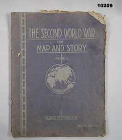
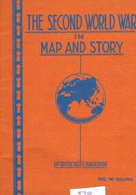
Book - ATLAS, Argus Newspaper, The Second World War in Map and Story. Volume 2, c. WW2
... The Second World War in Map and Story. Volume 2....Text on cover in white print. Map of World printed below title. Pages feature text in black type and maps in colour....The Second World War in Map and Story. Volume 2. Book ATLAS Argus Newspaper Neville Smith Robert M. ...Part of the "Kevin John Herdman" (No. 397661) Collection. See Catalogue No. 5942P for details of his service.Blue coloured textured cover with pages secured with two staples. Un-numbered white pages with cut edges. Text on cover in white print. Map of World printed below title. Pages feature text in black type and maps in colour.Handwritten in blue ink on first page: "H. Kofoed, Mandurang".kevin john herdman, maps, ww2, atlas -
 Bendigo Military Museum
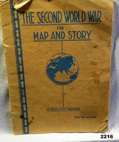
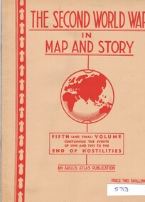
Book - BOOK WW2, The Second World War in Map and Story, During the WW2
... The Second World War in Map and Story...Title at top, globe depiction of the world central at bottom "An Argus Production, Price Two shillings. 63 pages of history with full page map every 2nd page....The Second World War in Map and Story Book BOOK WW2 ...Covers are yellow/orange with all writing in blue. Title at top, globe depiction of the world central at bottom "An Argus Production, Price Two shillings. 63 pages of history with full page map every 2nd page.books, maps, story -
 Greensborough Historical Society
Book, Neville Smith, The Second World War in map and story, ed. by Neville Smith, 1941_
... The Second World War in map and story, ed. by Neville Smith...Greensborough Historical Society 34A Glenauburn Road Lower Plenty Lower Plenty melbourne Series of articles first published in the "Argus" from 1941 to 1945, dealing with events and campaigns in World War 2. world war 2 63 p., black & white photographs, col. maps. The Second World War in map and story, ed. by Neville Smith Book Book Neville Smith Argus Atlas Robert N Myers ...Series of articles first published in the "Argus" from 1941 to 1945, dealing with events and campaigns in World War 2.63 p., black & white photographs, col. maps.world war 2 -
 Greensborough Historical Society
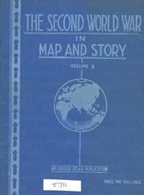
Book, Neville Smith, The Second World War in Map and Story, volume 3, ed. by Neville Smith, 1943_
... The Second World War in Map and Story, volume 3, ed. by Neville Smith...Greensborough Historical Society 34A Glenauburn Road Lower Plenty Lower Plenty melbourne Series of articles published by the "Argus" 1941-1943, dealing with events and campaigns in World War 2. world war 2 48 p., col. maps. The Second World War in Map and Story, volume 3, ed. by Neville Smith Book Book Neville Smith Argus Atlas Robert N Myers ...Series of articles published by the "Argus" 1941-1943, dealing with events and campaigns in World War 2.48 p., col. maps.world war 2 -
 Greensborough Historical Society
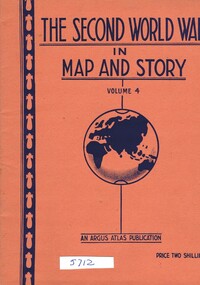
Book, Neville Smith, The Second World War in Map and Story, volume 4, ed. by Neville Smith, 1944_07
... The Second World War in Map and Story, volume 4, ed. by Neville Smith...Greensborough Historical Society 34A Glenauburn Road Lower Plenty Lower Plenty melbourne Series of articles published by the "Argus" 1941-1945, dealing with events and campaigns in World War 2. world war 2 48 p., col. maps. The Second World War in Map and Story, volume 4, ed. by Neville Smith Book Neville Smith Argus Atlas Robert N Myers ...Series of articles published by the "Argus" 1941-1945, dealing with events and campaigns in World War 2.48 p., col. maps.world war 2 -
 Greensborough Historical Society
Book, Neville Smith, The Second World War in map and story, Vol. 5, ed. by Neville Smith, 1945_
... The Second World War in map and story, Vol. 5, ed. by Neville Smith...Greensborough Historical Society 34A Glenauburn Road Lower Plenty Lower Plenty melbourne Series of articles first published in the "Argus" from 1941 to 1945, dealing with events and campaigns in World War 2. world war 2 50 p., black & white photographs, col. maps. The Second World War in map and story, Vol. 5, ed. by Neville Smith Book Book Neville Smith Argus Atlas Robert N Myers ...Series of articles first published in the "Argus" from 1941 to 1945, dealing with events and campaigns in World War 2.50 p., black & white photographs, col. maps.world war 2 -
 Monbulk RSL Sub Branch
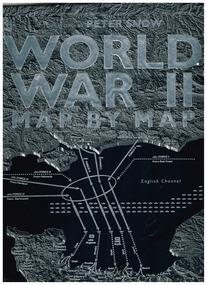
Book, Hugo Wilkinson, World War II map by map, 2019
... World War II map by map...World War II map by map Book Hugo Wilkinson Penguin Random House ...Maps and descriptions of important events in WWIIIll, maps, index, p.276.non-fictionMaps and descriptions of important events in WWIIworld war 1939-1945, world war 1939-1945 - pictorial works -
 Ringwood RSL Sub-Branch
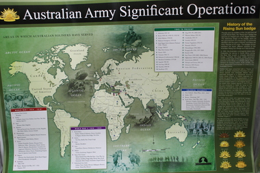
Work on paper - Australian army significant operations map, Memorabilia
... World map of operations x 2...Ringwood RSL Sub-Branch 16 Station Street Ringwood melbourne World map of operations x 2 Memorabilia Work on paper Australian army significant operations map ...World map of operations x 2 -
 B-24 Liberator Memorial Restoration Australia Inc
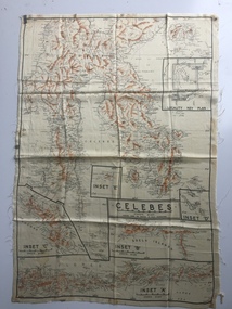
Map - Australian World War II silk map of Celebes, 1940s
... Australian World War II silk map of Celebes ...Silk and rayon maps were produced by Australia, Great Britain (some 1.75 million in total) and the United States (c.7.5 million) during World War II. ...This silk map, one of relatively few produced in Australia (most Australian RAAF pilots and crew were issued with British and US maps), is an original map from World War II. world war ii silk maps australia a185 'Prepared under the direction of RAAF Headquarters' Celebes (with Insets 'A' to 'E') An oblong, cream colour, single-sided map printed in black and white with brown contours, Celebes Map Australian World War II silk map of Celebes ...Silk and rayon maps were produced by Australia, Great Britain (some 1.75 million in total) and the United States (c.7.5 million) during World War II. They were issued to Allied military personnel as part of 'escape and evasion' kits.This silk map, one of relatively few produced in Australia (most Australian RAAF pilots and crew were issued with British and US maps), is an original map from World War II.An oblong, cream colour, single-sided map printed in black and white with brown contours, Celebes 'Prepared under the direction of RAAF Headquarters' Celebes (with Insets 'A' to 'E')world war ii, silk maps, australia, a185 -
 B-24 Liberator Memorial Restoration Australia Inc
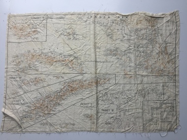
Map - Australian World War II silk map of Banda Sea, 1940s
... Australian World War II silk map of Banda Sea...Silk and rayon maps were produced by Australia, Great Britain (some 1.75 million in total) and the United States (c.7.5 million) during World War II. ...This silk map, one of relatively few produced in Australia (most Australian RAAF pilots and crew were issued with British and US maps), is an original map from World War II. world war ii silk maps australia a186 Banda Sea (with Insets 'A' to 'E') An oblong, cream colour, single-sided map printed in black and white with brown contours, Banda Sea Map Australian World War II silk map of Banda Sea ...Silk and rayon maps were produced by Australia, Great Britain (some 1.75 million in total) and the United States (c.7.5 million) during World War II. They were issued to Allied military personnel as part of 'escape and evasion' kits.This silk map, one of relatively few produced in Australia (most Australian RAAF pilots and crew were issued with British and US maps), is an original map from World War II.An oblong, cream colour, single-sided map printed in black and white with brown contours, Banda Sea Banda Sea (with Insets 'A' to 'E')world war ii, silk maps, australia, a186 -
 B-24 Liberator Memorial Restoration Australia Inc
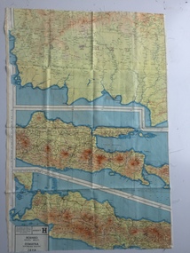
Map - British World War II silk map of Sumatra (South) and Java (Extreme North West), 1944
... British World War II silk map of Sumatra (South) and Java (Extreme North West)...Silk and rayon maps were produced by Great Britain (some 1.75 million in total), the United States (c.7.5 million) and Australia during World War II. ...This map, printed on rayon, is an original British 'escape and evasion' kit map from World War II. world war ii silk maps great britain a187 Sheet G Sumatra (South) and Java (Extreme North West) and, on the reverse, Sheet H Borneo (South West), Java and Sumatra (Extreme South) A multi-coloured, contoured, double-sided map printed on rayon, 1944 Series South West Pacific Area (SWPA) and Asia Map British World War II silk map of Sumatra (South) and Java (Extreme North West) ...Silk and rayon maps were produced by Great Britain (some 1.75 million in total), the United States (c.7.5 million) and Australia during World War II. They were issued to Allied military personnel as part of 'escape and evasion' kits.This map, printed on rayon, is an original British 'escape and evasion' kit map from World War II.A multi-coloured, contoured, double-sided map printed on rayon, 1944 Series South West Pacific Area (SWPA) and Asia Sheet G Sumatra (South) and Java (Extreme North West) and, on the reverse, Sheet H Borneo (South West), Java and Sumatra (Extreme South)world war ii, silk maps, great britain, a187 -
 B-24 Liberator Memorial Restoration Australia Inc
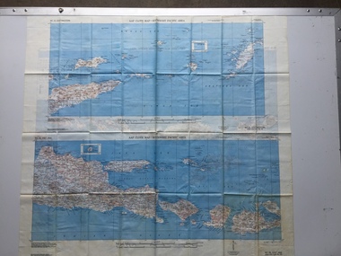
Map - US World War II-coloured map, - Southwest Pacific Area, No.22 Southwestern, No.26 East Java, No.25 Timor, 1943
... US World War II-coloured map, - Southwest Pacific Area, No.22 Southwestern, No.26 East Java, No.25 Timor...Silk and rayon maps were produced by the United States (c. 7.5 million in total), Great Britain (some 1.75 million in total) and Australia during World War II. ...This map, printed on acetate rayon, is an original US 'escape and evasion' kit map from World War II. world war ii silk maps united states of america a188 AAF Cloth Map - Southwest Pacific Area Side 1 - No. 22 Southwestern and No. 26 East Java Side 2 - No. 25 Timor A multi-coloured, contoured, double-sided map printed on acetate rayon Map US World War II-coloured map, - Southwest Pacific Area, No.22 Southwestern, No.26 East Java, No.25 Timor ...Silk and rayon maps were produced by the United States (c. 7.5 million in total), Great Britain (some 1.75 million in total) and Australia during World War II. They were issued to Allied military personnel as part of 'escape and evasion' kits.This map, printed on acetate rayon, is an original US 'escape and evasion' kit map from World War II.A multi-coloured, contoured, double-sided map printed on acetate rayon AAF Cloth Map - Southwest Pacific Area Side 1 - No. 22 Southwestern and No. 26 East Java Side 2 - No. 25 Timorworld war ii, silk maps, united states of america, a188 -
Moorabbin Air Museum
Map (item) - Pan Am map of world flights 1980
... Pan Am map of world flights 1980...Moorabbin Air Museum Moorabbin Airport 12 First Street Moorabbin melbourne Map Pan Am map of world flights 1980 ... -
 Warrnambool and District Historical Society Inc.
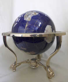
Decorative object - Trophy, World globe horseracing trophy
... Large sphere map of the world. Blue in colour with world map. ...Warrnambool and District Historical Society Inc. 2 Gilles Street (south of Merri St) Warrnambool great-ocean-road Won by thoroughbred horse Mega Pixel at the Warrnambool May carnival warrnambool horse racing globe may carnival Mega Pixel Large sphere map of the world. Blue in colour with world map. ...Won by thoroughbred horse Mega Pixel at the Warrnambool May carnivalLarge sphere map of the world. Blue in colour with world map. Supported on standwarrnambool, horse racing, globe, may carnival, mega pixel -
 Stawell Historical Society Inc
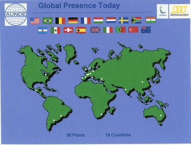
Photograph - Aunde Album 29, Global Presence Today, 2002
... Colour landscape photo: World map with flags, white dots showing locations of 56 plants in 19 coutries....Esteban logo, Isinghausen logo, Aunde logo with flags Colour landscape photo: World map with flags, white dots showing locations of 56 plants in 19 coutries. ...Aunde / Norwellan Textiles North Western Woollen Mills became Norwellan Textiles then AUNDEColour landscape photo: World map with flags, white dots showing locations of 56 plants in 19 coutries.Global Presence 56 plants in 19 Countries. Esteban logo, Isinghausen logo, Aunde logo with flagsindustry, aunde -
 Melbourne Tram Museum
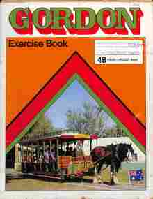
Drawing - Exercise book, David Frost, VR Electric trams, 1955
... Exercise book with newspaper cuttings and drawings of VR trams, some coloured with a coloured world map on the rear cover....David trained as a draftsman. tramways trams VR Trams tram 20 tram 54 tram 29 tram 50 tram 7 Exercise book with newspaper cuttings and drawings of VR trams, some coloured with a coloured world map on the rear cover. VR Electric trams Drawing Exercise book David Frost ...Prepared by David Frost using a Gordon Exercise book with a horse-drawn crossbench tram (destination of Bird Life Park - Gold Coast) and with most pages removed. One drawing dated 1955 and another 1957. Contents: 1 - Location map of VR tram 35 in Tyabb 2 - Newspaper item titled "End of the Line" by Stephen Foley, in the "Then and Now" section about former VR tram 20, collected by Bob Prentice 3 - Drawing of VR 29 - floor plan and side elevation 4 - Drawing of VR 54 - floor plan and elevations 5 - Isometric drawing of VR 54 coloured 6 - Drawing of VR 50 - floor plan and elevations, coloured 7 - Isometric drawing of VR 7 - colouredDemonstrates work by David Frost in preparing drawings of trams. David trained as a draftsman.Exercise book with newspaper cuttings and drawings of VR trams, some coloured with a coloured world map on the rear cover.tramways, trams, vr trams, tram 20, tram 54, tram 29, tram 50, tram 7 -
 National Vietnam Veterans Museum (NVVM)
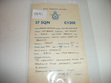
Card, 37 Squadron C130E
... On the back is hand written information. World map (partial) in blue ink on the back....On the back is hand written information. World map (partial) in blue ink on the back. 37 Squadron C130E. ...RAAF yellow card with blue printing. On the back is hand written information. World map (partial) in blue ink on the back.37 sqn raaf -
 Stawell Historical Society Inc
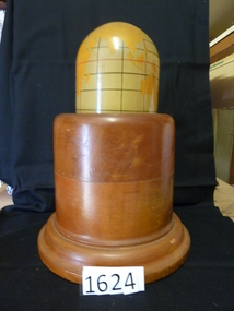
Memorabilia - Realia, 1943
... Polished Wooden Base. World Map painted o Mercator's for projection. ...Polished Wooden Base. World Map painted o Mercator's for projection. ...Lamp. Polished Wooden Base. World Map painted o Mercator's for projection. Timber from first Anglican Church.stawell, education -
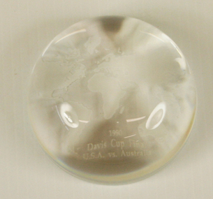 Tennis Australia
Commemorative Gift, 1990
... Glass paperweight with image of world map and caption '1990 Davis Cup Final, USA vs Australia' Materials: Glass...Tennis Australia Melbourne Park Olympic Boulevard Melbourne Park Melbourne melbourne Tennis Glass paperweight with image of world map and caption '1990 Davis Cup Final, USA vs Australia' Materials: Glass Commemorative Gift ...Glass paperweight with image of world map and caption '1990 Davis Cup Final, USA vs Australia' Materials: Glasstennis -
Glenelg Shire Council Cultural Collection
Book, The British Empire with its World Setting, c. 1916
... Hardback, red with black print and line drawing world map, front cover, British Empire in solid black. ...PORTLAND' - Black ink Back: 17.1 x 12.2 x 1.7 Hardback, red with black print and line drawing world map, front cover, British Empire in solid black. ...history; British Empire; world historyHardback, red with black print and line drawing world map, front cover, British Empire in solid black. Junior geography textbook with black and white mapshistory; British Empire; world history -
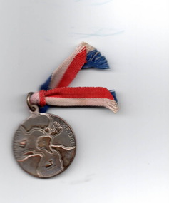 Hume City Civic Collection
Medal, Lyndon Dadswell, Victory Medal, 1945
... The words 'Victory Medal' with a world map are on one side and a soldier with a sword and map of Australia with 1945 are on the other side....The words 'Victory Medal' with a world map are on one side and a soldier with a sword and map of Australia with 1945 are on the other side. ...A Victory Medal was given to school children after the end of World War 2 in 1945. 1 150 000 of these medals were distributed to Australian school children to coincide with the end of the war in the Pacific in August 1945. It was designed by Lyndon Dadswell and the makers were Stokes & Sons.The medal was one way generations would know about Worlds War 2 in 1945.A small medal with a striped red, white and blue ribbon threaded through an eyelet at the top. The words 'Victory Medal' with a world map are on one side and a soldier with a sword and map of Australia with 1945 are on the other side.victory medal, world war 2, schools, medals -
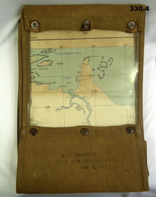 Bendigo Military Museum
Map - MAP CASE & MAPS, Hec Robinson, C.1939-45
... ...Second World War...Map...At discharge on 30.11.45 he held the rank of WO 2nd class in 2/108th Aust Light Anti Aircraft detachment. Maps WWII World War Two Second World War Map Cases Darwin Northern Territory Pine Creek Papua New Guinea Navigation Pouches zippered section marked "J. ...John James Davies No VX35280 enlisted in the 2nd AIF on 1.8.40 age 31 years. At discharge on 30.11.45 he held the rank of WO 2nd class in 2/108th Aust Light Anti Aircraft detachment..1) Map case, canvas khaki. .2) Map of Darwin, NT. Scale 4 miles to 1 inch. .3) Map, folded, New Guinea made by Hec Robinson Sydney .4) Map Pine Creek N.T.zippered section marked "J. J. Davies VX35280 108 LAD”maps, wwii, world war two, second world war, map cases, darwin, northern territory, pine creek, papua new guinea, navigation, pouches -
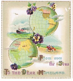 Bendigo Historical Society Inc.
Document - MALONE COLLECTION: GREETING CARDS
... At the top is a world map with N & S America on it and diagonally below it is another world map with Africa, Europe, Asia and Australia on it. ...At the top is a world map with N & S America on it and diagonally below it is another world map with Africa, Europe, Asia and Australia on it. ...Small white card with a gold, dashed border. At the top is a world map with N & S America on it and diagonally below it is another world map with Africa, Europe, Asia and Australia on it. There are 2 small bunches of pansies at the top of the America globe, a larger one between the two globes and a purple pansy below the lower globe. On the left of the globes is a coloured picture of a ship and on the right, a picture of people in a red car travelling in the country. Grey shading inside the gold border. 'From over the Seas To the Dear Homeland' printed in gold, blue and purple at the bottom.person, greeting cards, malone collection, malone collection, greeting cards -
Port Melbourne Historical & Preservation Society
Pamphlet - Brochure, International Container Terminal Services Inc, Victoria International Container Terminal (Vict), Melbourne Australia
... Coloured advertising brochure with photo of three cranes at Webb Dock east on cover front. Back cover has world map showing locations of International Container Terminal Services Inc. ...Port Melbourne Historical & Preservation Society Port Melbourne Town Hall 333 Bay Street Port Melbourne melbourne maritime piers and wharves - webb dock victoria international container terminal webb dock east Coloured advertising brochure with photo of three cranes at Webb Dock east on cover front. Back cover has world map showing locations of International Container Terminal Services Inc. ...Coloured advertising brochure with photo of three cranes at Webb Dock east on cover front. Back cover has world map showing locations of International Container Terminal Services Inc. Inside has photos and text about location, services and the company.maritime, piers and wharves - webb dock, victoria international container terminal, webb dock east