Showing 1113 items matching "world maps"
-
 Lara RSL Sub Branch
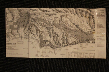
Group of Maps World War One, Group of Maps World War One - Dardanelles and Anzac Gallipoli Maps Circ 1915, Circ 1916
... Group of Maps World War One...Group of Maps World War One - Dardanelles and Anzac Gallipoli Maps Circ 1915...Gallipoli 1915 Maps and Naval plan of Operations World War One ANZAC...(and copy).. 4. Map of ANZAC Trench Diagram. World War One.Color. (and copy). 5.Panorama of Chunuk Blair from 3 miles south of Nibrunesi Point, 3 November 1915 and Anzac from 1 mile N. ...Australian War Memorial, 6. Map of ANZAC positions of World War One, Gallipoli 1915. ...Color Map of ANZAC positions with topographical Details, notes. Group of Maps World War One - Dardanelles and Anzac Gallipoli Maps Circ 1915 Group of Maps World War One ...Gallipoli 1915 Maps and Naval plan of Operations World War One ANZACRare examples that explain both ANZAC and Naval Operations during World War One Gallipoli & Dardanelles Passage .!. Black and White Photocopy of Gallipoli 1915 ANZAC Battlefield - detailed positions of troops and Cemeteries. 2.The Allied Failure to Force The Dardanelles Passage 18 March 1915 - detailed line of Attack Naval Organisation, Mine layout, Plan of Attack (and copy).. 3. Map of Turkey and surrounding area written in Turkish and German Languages. C0olor version main roads and distances. (and copy).. 4. Map of ANZAC Trench Diagram. World War One.Color. (and copy). 5.Panorama of Chunuk Blair from 3 miles south of Nibrunesi Point, 3 November 1915 and Anzac from 1 mile N. E. of Ari Burnu, 21 November 1915. Black & White 6. Color Map of ANZAC positions with topographical Details, notes. 1. Artwork and copyright by Srewart Cownie, Gallipoli 1915 ANZAC Battlefield with Landings and later evacuation marked. 2. Details of Naval actions taken in the Dardanelles Passage 18 March 1918. 3. Local area Map or Turkey. Shows roads network and townships. 4. ANZAC Trench Diagram, copyright Whitcombe & Tombs Limited , Wellington N.Z. 1919 5. Panorama of two coast views of ANZAC area. Australian War Memorial, 6. Map of ANZAC positions of World War One, Gallipoli 1915. Published by H.E.C. Roberinson, George Street, Sydney N.S.W.18 April 1916maps operational of anzac and naval opations during 1915 etc, dardanelles naval opations -
 National Wool Museum
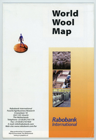
Map - World Wool Map, Rabobank International, c.2002
... World Wool Map...Folded world map showing statistics, images and graphics relating to wool in the 1990's....front: World Wool Map / Rabobank / International / Rabobank International / Food & Agricultural Research / Croeselaan 18 / 3521 CB Utrecht / The Netherlands / Telephone +31 (0) 30 2161178 / Fax +31 (0) 30 2161920 / E-mail: [email protected] / Web-site:www.rabobank.com/far / Map produced by G-O graphics / Wijk bij Duurstede, The Netherlands / www.g-o-graphics.nl...Map World Wool Map Rabobank International ...Part of a collection of books, manuals, photographs, letters and clothing relating to the working life of Stuart Ascough. Stuart's career in the wool industry spanned over 43 years from 1960 to 2003 in various roles including Topmaking Plant Manager at Courtaulds Ltd. in Spennymore, U.K., Operations Manager at Port Phillip Mills in Williamstown Victoria, Marketing Executive, Early Stage Wool Processing at the International Wool Secretariat Melbourne, Australia and General Manager of Victoria Wool Processors Pty. Ltd. in Laverton North, Victoria. Throughout his career Stuart travelled extensively, and in the 1990s worked at many topmaking mills in China on quality improvement projects. He also provided technical advice and training at mills in India, Ukraine, Lithuania, Kyrgyzstan, Russia, Latvia, Byelorussia and other parts of Europe and Asia.Folded world map showing statistics, images and graphics relating to wool in the 1990's.front: World Wool Map / Rabobank / International / Rabobank International / Food & Agricultural Research / Croeselaan 18 / 3521 CB Utrecht / The Netherlands / Telephone +31 (0) 30 2161178 / Fax +31 (0) 30 2161920 / E-mail: [email protected] / Web-site:www.rabobank.com/far / Map produced by G-O graphics / Wijk bij Duurstede, The Netherlands / www.g-o-graphics.nlstuart ascough, international wool secretariat, victoria wool processors, port phillip mills pty ltd, topmaking, career, wool industry, training, technical advice, mills, map -
 Bendigo Historical Society Inc.
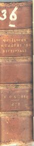
Book - A DICTIONARY GEOGRAPHICAL, STASTISTICAL, AND HISTORICAL. VOL. II
... ... world... maps...A hard covered book titled, '' A Dictionary, Geographical, Statistical, and Historical, of the various countries, places, and principal natural objects in The World. Illustrated with maps. By J.R. McCulloch, Esq. Member of the Institute of France. ...History House 11 Mackenzie Street Bendigo goldfields BOOK geography book books reference geography stastistics history world maps Europe world place dictionary dictionaries encyclopaedia Eaglehawk Publlic Library J.R. ...A hard covered book titled, '' A Dictionary, Geographical, Statistical, and Historical, of the various countries, places, and principal natural objects in The World. Illustrated with maps. By J.R. McCulloch, Esq. Member of the Institute of France. A new edition revised, with a supplement. In two volumes. Vol. II. London : Longman, Brown, Green, and Longmans. MDCCCLIV.'' Handwritten in ink is the number 36. 983 pgs. (maps)J.R. McCulloch, Esq.book, geography, book, books, reference, geography, stastistics, history, world, maps, europe, world, place, dictionary, dictionaries, encyclopaedia, eaglehawk publlic library -
 Ringwood RSL Sub-Branch
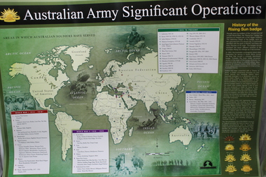
Work on paper - Australian army significant operations map, Memorabilia
... World map of operations x 2...Ringwood RSL Sub-Branch 16 Station Street Ringwood melbourne World map of operations x 2 Memorabilia Work on paper Australian army significant operations map ...World map of operations x 2 -
 Warrnambool and District Historical Society Inc.
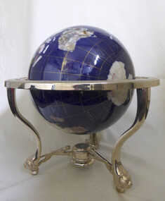
Decorative object - Trophy, World globe horseracing trophy
... Large sphere map of the world. Blue in colour with world map. ...Warrnambool and District Historical Society Inc. 2 Gilles Street (south of Merri St) Warrnambool great-ocean-road Won by thoroughbred horse Mega Pixel at the Warrnambool May carnival warrnambool horse racing globe may carnival Mega Pixel Large sphere map of the world. Blue in colour with world map. ...Won by thoroughbred horse Mega Pixel at the Warrnambool May carnivalLarge sphere map of the world. Blue in colour with world map. Supported on standwarrnambool, horse racing, globe, may carnival, mega pixel -
 Bendigo Historical Society Inc.
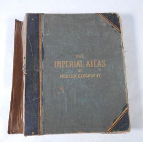
Book - Atlas, The Imperial Atlas of Modern Geography, 1860
... World maps...The atlas includes an extensive series of maps embracing the most recent discoveries and the latest political divisions of territory in all parts of the world compiled and engraved from the most authentic sources. ...In 185, his successful business in Glasgow, employed 60 men and 40 boys. World maps Index The Imperial Atlas of Modern Geography published in London by Blackie and Son, Warwick Square, E.C.; Glasgow and Edinburgh in 1860 MDCCCLX. ...Publisher Walter Graham Blackie (1816-1906) began as a letterpress operator, printer and publisher. He married Marion Brodie 16/4/1846. In 185, his successful business in Glasgow, employed 60 men and 40 boys.The Imperial Atlas of Modern Geography published in London by Blackie and Son, Warwick Square, E.C.; Glasgow and Edinburgh in 1860 MDCCCLX. The atlas includes an extensive series of maps embracing the most recent discoveries and the latest political divisions of territory in all parts of the world compiled and engraved from the most authentic sources. world maps, index -
 Stawell Historical Society Inc
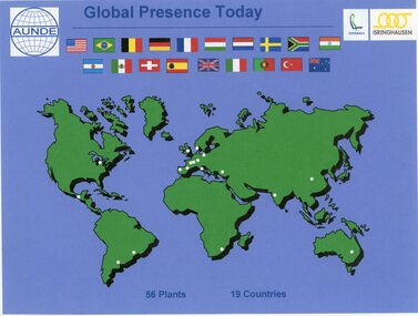
Photograph - Aunde Album 29, Global Presence Today, 2002
... Colour landscape photo: World map with flags, white dots showing locations of 56 plants in 19 coutries....Esteban logo, Isinghausen logo, Aunde logo with flags Colour landscape photo: World map with flags, white dots showing locations of 56 plants in 19 coutries. ...Aunde / Norwellan Textiles North Western Woollen Mills became Norwellan Textiles then AUNDEColour landscape photo: World map with flags, white dots showing locations of 56 plants in 19 coutries.Global Presence 56 plants in 19 Countries. Esteban logo, Isinghausen logo, Aunde logo with flagsindustry, aunde -
 Melbourne Tram Museum
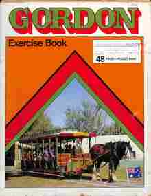
Drawing - Exercise book, David Frost, VR Electric trams, 1955
... Exercise book with newspaper cuttings and drawings of VR trams, some coloured with a coloured world map on the rear cover....David trained as a draftsman. tramways trams VR Trams tram 20 tram 54 tram 29 tram 50 tram 7 Exercise book with newspaper cuttings and drawings of VR trams, some coloured with a coloured world map on the rear cover. VR Electric trams Drawing Exercise book David Frost ...Prepared by David Frost using a Gordon Exercise book with a horse-drawn crossbench tram (destination of Bird Life Park - Gold Coast) and with most pages removed. One drawing dated 1955 and another 1957. Contents: 1 - Location map of VR tram 35 in Tyabb 2 - Newspaper item titled "End of the Line" by Stephen Foley, in the "Then and Now" section about former VR tram 20, collected by Bob Prentice 3 - Drawing of VR 29 - floor plan and side elevation 4 - Drawing of VR 54 - floor plan and elevations 5 - Isometric drawing of VR 54 coloured 6 - Drawing of VR 50 - floor plan and elevations, coloured 7 - Isometric drawing of VR 7 - colouredDemonstrates work by David Frost in preparing drawings of trams. David trained as a draftsman.Exercise book with newspaper cuttings and drawings of VR trams, some coloured with a coloured world map on the rear cover.tramways, trams, vr trams, tram 20, tram 54, tram 29, tram 50, tram 7 -
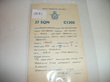 National Vietnam Veterans Museum (NVVM)
Card, 37 Squadron C130E
... On the back is hand written information. World map (partial) in blue ink on the back....On the back is hand written information. World map (partial) in blue ink on the back. 37 Squadron C130E. ...RAAF yellow card with blue printing. On the back is hand written information. World map (partial) in blue ink on the back.37 sqn raaf -
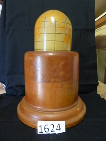 Stawell Historical Society Inc
Memorabilia - Realia, 1943
... Polished Wooden Base. World Map painted o Mercator's for projection. ...Polished Wooden Base. World Map painted o Mercator's for projection. ...Lamp. Polished Wooden Base. World Map painted o Mercator's for projection. Timber from first Anglican Church.stawell, education -
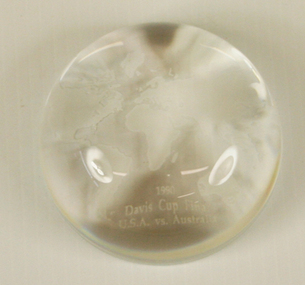 Tennis Australia
Commemorative Gift, 1990
... Glass paperweight with image of world map and caption '1990 Davis Cup Final, USA vs Australia' Materials: Glass...Tennis Australia Melbourne Park Olympic Boulevard Melbourne Park Melbourne melbourne Tennis Glass paperweight with image of world map and caption '1990 Davis Cup Final, USA vs Australia' Materials: Glass Commemorative Gift ...Glass paperweight with image of world map and caption '1990 Davis Cup Final, USA vs Australia' Materials: Glasstennis -
 Glenelg Shire Council Cultural Collection
Book, The British Empire with its World Setting, c. 1916
... Hardback, red with black print and line drawing world map, front cover, British Empire in solid black. ...PORTLAND' - Black ink Back: 17.1 x 12.2 x 1.7 Hardback, red with black print and line drawing world map, front cover, British Empire in solid black. ...history; British Empire; world historyHardback, red with black print and line drawing world map, front cover, British Empire in solid black. Junior geography textbook with black and white mapshistory; British Empire; world history -
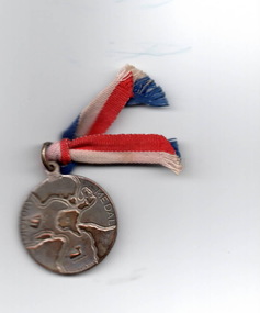 Hume City Civic Collection
Medal, Lyndon Dadswell, Victory Medal, 1945
... The words 'Victory Medal' with a world map are on one side and a soldier with a sword and map of Australia with 1945 are on the other side....The words 'Victory Medal' with a world map are on one side and a soldier with a sword and map of Australia with 1945 are on the other side. ...A Victory Medal was given to school children after the end of World War 2 in 1945. 1 150 000 of these medals were distributed to Australian school children to coincide with the end of the war in the Pacific in August 1945. It was designed by Lyndon Dadswell and the makers were Stokes & Sons.The medal was one way generations would know about Worlds War 2 in 1945.A small medal with a striped red, white and blue ribbon threaded through an eyelet at the top. The words 'Victory Medal' with a world map are on one side and a soldier with a sword and map of Australia with 1945 are on the other side.victory medal, world war 2, schools, medals -
 Bendigo Historical Society Inc.
Document - MALONE COLLECTION: GREETING CARDS
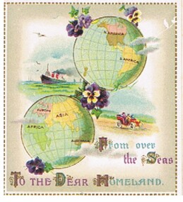
... At the top is a world map with N & S America on it and diagonally below it is another world map with Africa, Europe, Asia and Australia on it. ...At the top is a world map with N & S America on it and diagonally below it is another world map with Africa, Europe, Asia and Australia on it. ...Small white card with a gold, dashed border. At the top is a world map with N & S America on it and diagonally below it is another world map with Africa, Europe, Asia and Australia on it. There are 2 small bunches of pansies at the top of the America globe, a larger one between the two globes and a purple pansy below the lower globe. On the left of the globes is a coloured picture of a ship and on the right, a picture of people in a red car travelling in the country. Grey shading inside the gold border. 'From over the Seas To the Dear Homeland' printed in gold, blue and purple at the bottom.person, greeting cards, malone collection, malone collection, greeting cards -
Port Melbourne Historical & Preservation Society
Pamphlet - Brochure, International Container Terminal Services Inc, Victoria International Container Terminal (Vict), Melbourne Australia
... Coloured advertising brochure with photo of three cranes at Webb Dock east on cover front. Back cover has world map showing locations of International Container Terminal Services Inc. ...Port Melbourne Historical & Preservation Society Port Melbourne Town Hall 333 Bay Street Port Melbourne melbourne maritime piers and wharves - webb dock victoria international container terminal webb dock east Coloured advertising brochure with photo of three cranes at Webb Dock east on cover front. Back cover has world map showing locations of International Container Terminal Services Inc. ...Coloured advertising brochure with photo of three cranes at Webb Dock east on cover front. Back cover has world map showing locations of International Container Terminal Services Inc. Inside has photos and text about location, services and the company.maritime, piers and wharves - webb dock, victoria international container terminal, webb dock east -
 Montmorency–Eltham RSL Sub Branch
Map - Framed 1915 Anzac Cove Map, Gallipoli, 1915.ANZAC Cove Map, 1915
... world war one...anzac...gallipoli...1915...anzac cove...map...Gallipoli - Anzac Cove World War One Map - 1915...Montmorency–Eltham RSL Sub Branch Petrie Park 16 Mountain View Road Montmorency melbourne world war one anzac gallipoli 1915 anzac cove map dardenelles trench lines depth soundings landing areas Gallipoli - Anzac Cove World War One Map - 1915 A framed map depicting trench lines and the battlefields of the Gallipoli Campaign, 1915, made by the Survey Department Egypt. ...A framed map depicting trench lines and the battlefields of the Gallipoli Campaign, 1915, made by the Survey Department Egypt. Depth soundings of landing areas off Anzac Cove.Gallipoli - Anzac Cove World War One Map - 1915world war one, anzac, gallipoli, 1915, anzac cove, map, dardenelles, trench lines, depth soundings, landing areas -
 Monbulk RSL Sub Branch
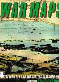
Book, McDonald, War maps, 1982
... World War 1939-1945 - Maps...Monbulk RSL Sub Branch 48 Main Road Monbulk yarra-valley-and-the-dandenong-ranges World War 1939-1945 - Maps World War 1939-1945 - Campaigns Maps of World War II campaigns from September 1939 to August 1945, air, sea and land, battle by battle. ...Maps of World War II campaigns from September 1939 to August 1945, air, sea and land, battle by battle.Index, bib, ill, maps, p.186.non-fictionMaps of World War II campaigns from September 1939 to August 1945, air, sea and land, battle by battle.world war 1939-1945 - maps, world war 1939-1945 - campaigns -
 Bendigo Historical Society Inc.
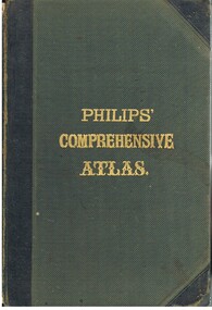
Book - LYDIA CHANCELLOR COLLECTION: PHILLIPS' COMPREHENSIVE ATLAS
... MAP...Lydia Chancellor collection... collection... atlas... maps... world...History House 11 Mackenzie Street Bendigo goldfields MAP Lydia Chancellor collection collection atlas maps world book books Edited by William Hughes, F.R.G.S. ...A gray hard covered atlas titled ' Phillips' Comprehensive Atlas of Ancient and Modern Geography.' Edited by William Hughes, FRGS. London. George Phillip and Son, 32 Fleet St., Liverpool, Caxton Buildings, South John St., 1874. 42 pgs., maps, index. NB: In the inside cover of the book is a newspaper cutting of a letter from G. Wilson Brown Secretary, Education Department, Melbourne, 12th November, 1878 advertising 'an examination of Teachers and Candidates will be held at School 1,976, Sandhurst, on Thursday and Friday, 19th and 20th December, 1878, commencing at 9.30 a.m.'Edited by William Hughes, F.R.G.S.map, lydia chancellor collection, collection, atlas, maps, world, book, books -
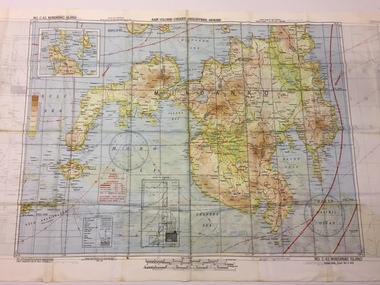 B-24 Liberator Memorial Restoration Australia Inc
Map - US World War II multi-coloured map - Philippine Series, No. C-43 Mindanao Series, No. C-44 North Borneo, 1944
... US World War II multi-coloured map - Philippine Series, No. ...maps...world war ii...Silk and rayon maps were produced by the United States (c. 7.5 million in total), Great Britain (some 1.75 million in total) and Australia during World War II. ...This map, printed on acetate rayon, is an original US 'escape and evasion' kit map from World War II. united states of america silk and rayon maps world war ii AAF Cloth Chart - Philippine Series Side 1 - No. ...Silk and rayon maps were produced by the United States (c. 7.5 million in total), Great Britain (some 1.75 million in total) and Australia during World War II. They were issued to Allied military personnel as part of 'escape and evasion' kits.This map, printed on acetate rayon, is an original US 'escape and evasion' kit map from World War II.A multi-coloured, contoured, double-sided map printed on acetate rayon AAF Cloth Chart - Philippine Series Side 1 - No. C-43 Mindanao Series Side 2 - No. C.44 North Borneounited states of america, silk and rayon maps, world war ii -
 B-24 Liberator Memorial Restoration Australia Inc
Map - US World War II multi-coloured map, Side 1 - No. C-47 South Borneo, Side 2 - No. C-48 West Java, 1944
... US World War II multi-coloured map, Side 1 - No. C-47 South Borneo, Side 2 - No. ...maps...world war ii...Silk and rayon maps were produced by the United States (c. 7.5 million in total), Great Britain (some 1.75 million in total) and Australia during World War II. ...This map, printed on acetate rayon, is an original US 'escape and evasion' kit map from World War II. united states of america silk and rayon maps world war ii a191 AAF Cloth Chart Side 1 - No. ...Silk and rayon maps were produced by the United States (c. 7.5 million in total), Great Britain (some 1.75 million in total) and Australia during World War II. They were issued to Allied military personnel as part of 'escape and evasion' kits.This map, printed on acetate rayon, is an original US 'escape and evasion' kit map from World War II.A multi-coloured, contoured, double-sided map printed on acetate rayon AAF Cloth Chart Side 1 - No. C-47 South Borneo Side 2 - No. C.48 West Javaunited states of america, silk and rayon maps, world war ii, a191 -
 Whitehorse Historical Society Inc.
Map - WW1 German Field Map, Übersichtskarte fur die 2. Armee (Nordabschnitt), C 1915
... Maps...World War 1914 - 1918...Scale 1 : 50,000 Rare German Field Map Maps World War 1914 - 1918 Honybun Charles Paper printed map of German Field positions Hand written English explanation of German Field Map (transcription stored with map) Details area bounded by Mt. ...Paper printed map of German Field positionsDetails area bounded by Mt. St. Quentin, Fresnoy, Riencourt, Canbrai and St AubertPaper printed map of German Field positionsmaps, world war 1914 - 1918, honybun charles -
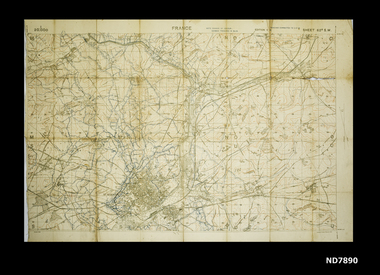
 Whitehorse Historical Society Inc.
Map - WW1 map of France, WW1 map of France - regional. Field Survey Map of Enemy Rear Organisation, 08/10/1918
... Maps...World War 1914 - 1918...Whitehorse Historical Society Inc. 2-10 Deep Creek Road Mitcham melbourne WW1 allied map of part of France - behind the enemy lines Shee 57A Military map used in WW1 Maps World War 1914 - 1918 Enemy Rear Organisation map Scale 1 : 40,000 Field Survey Map of Enemy Rear Organisation WW1 map of France - regional. ...Enemy Rear Organisation map Scale 1 : 40,000Field Survey Map of Enemy Rear Organisationnon-fictionEnemy Rear Organisation map Scale 1 : 40,000maps, world war 1914 - 1918 -
 Whitehorse Historical Society Inc.
Map, Area map of France trench map, 03/02/1918
... Maps...World War 1914 - 1918...Whitehorse Historical Society Inc. 2-10 Deep Creek Road Mitcham melbourne WW1 Allied map of German trenches WW1 France Trench Placements Maps World War 1914 - 1918 Coloured trench map of part of France Sheet 62B S.W. ...Coloured trench map of part of France Sheet 62B S.W. Scale 1 : 20,000non-fictionColoured trench map of part of France Sheet 62B S.W. Scale 1 : 20,000maps, world war 1914 - 1918 -
 Bendigo Military Museum
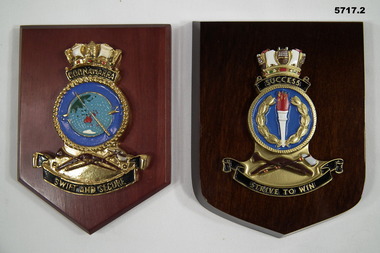
Plaque - PLAQUES, HMAS COONAWARRA & HMAS SUCCESS
... Wood, centre, metal painted gold, black, blue with a world map in blue painted centre crown on top with white and red decoration, crown on top. 2. ...Wood, centre, metal painted gold, black, blue with a world map in blue painted centre crown on top with white and red decoration, crown on top. 2. ...1. Wood, centre, metal painted gold, black, blue with a world map in blue painted centre crown on top with white and red decoration, crown on top. 2. Wood, centre, metal painted gold, black, blue and brown. Crown on top with white, brown, red and green decoration.1. "COONAWARRA" "SWIFT AND SECURE" 2. "SUCCESS" "STRIVE TO WIN".plaque, hmas coonawarra, hmas success -
Moorabbin Air Museum
Souvenir (item) - Pan Am map of world flights 1980
... Pan Am map of world flights 1980...Pan Am map of world flights 1980...foolscap paper map of world flights...Moorabbin Air Museum Moorabbin Airport 12 First Street Moorabbin melbourne foolscap paper map of world flights Pan Am map of world flights 1980 Souvenir Pan Am map of world flights 1980 ... -
 Lara RSL Sub Branch
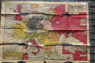
Newspaper - The Sun Newspaper Dated 5/8/1944 -specia - World War 2 Europe Map and History Of World War 2 and Nazi Tide Flows and Ebbs Across Europe, THe Sun Newspaper Dated 5/8//1944 - Special War Maps
... The Sun Newspaper Dated 5/8/1944 -specia - World War 2 Europe Map and History Of World War 2 and Nazi Tide Flows and Ebbs Across Europe...world war 2 europe map and hisytory of world war 2 and nazi tide flows and ebbs across europe...Local Newspaper Dated 5/8/1944 - Special World War 2 Maps... World War 2 Europe Map and History Of World War 2 and Nazi Tide Flows and Ebbs Across Europe...Lara RSL Sub Branch McClelland Ave Lara The Sun Newspaper Dated 5/8/1944 world war 2 europe map and hisytory of world war 2 and nazi tide flows and ebbs across europe World War 2 Europe Map and History Of World War 2 and Nazi Tide Flows and Ebbs Across Europe Local Newspaper Dated 5/8/1944 - Special World War 2 Maps THe Sun Newspaper Dated 5/8//1944 - Special War Maps Newspaper The Sun Newspaper Dated 5/8/1944 -specia - World War 2 Europe Map and History Of World War 2 and Nazi Tide Flows and Ebbs Across Europe ...The Sun Newspaper Dated 5/8/1944 Local Newspaper Dated 5/8/1944 - Special World War 2 Maps World War 2 Europe Map and History Of World War 2 and Nazi Tide Flows and Ebbs Across Europeworld war 2 europe map and hisytory of world war 2 and nazi tide flows and ebbs across europe -
 Warrnambool and District Historical Society Inc.
Book, World Publishing Co, Webster Dictionary, 1958
... The supplementary material includes coloured world maps, dictionaries of biography, geography and mythology and information on foreign words and phrases, abbreviations, Scripture and the history of Canada....The supplementary material includes coloured world maps, dictionaries of biography, geography and mythology and information on foreign words and phrases, abbreviations, Scripture and the history of Canada. ...This dictionary is a large tome containing a wealth of information current at the time of publication (1958). The Webster’s Dictionary is an American publication but it was known world-wide and would have been in many households in Australia in the mid 20th century. No information is available on A. M. Archibald (the signature in the front of the book)This book has no known local provenance but is retained as an example of an antiquarian item, a 60 year-old book.This is a large tome of 2129 pages, plus supplements of 160 pages. It has a faded dark green linen cover. The spine and the cover edges are damaged. The wording on the spine and cover are almost indecipherable. Inside the covers are images of a tree with branches representing Indo-European languages. The pages have alphabetical thumb tabs and these are double-sided with gold lettering. The pages contain black and white illustrations and coloured plates. The supplementary material includes coloured world maps, dictionaries of biography, geography and mythology and information on foreign words and phrases, abbreviations, Scripture and the history of Canada.A.M. Archibald Webster’s Dictionary antiquarian books, history of warrnambool -
 Bendigo Military Museum
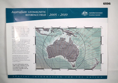
Flyer - Australian Geomagnetic Reference Field 2005-2010, Geoscience Australia, 2005
... The reverse side shows a world map with lines of magnetic declination at five-degree intervals. ...The reverse side shows a world map with lines of magnetic declination at five-degree intervals. ...Front side shows a map of australia with red lines of Magnetic Declination and blue lines depicting contours of the projected rate of declination change 2005 - 2010. The reverse side shows a world map with lines of magnetic declination at five-degree intervals. There are also three smaller Australian maps showing contours of "Total Field", "Horizontal Field (H)" and "Vertical Field (V)." Magnetic information was used extensively on the majority of maps produced by the Royal Australian Survey Corps, both topographic and aeronautical.Single A4 size sheet printed in colour on both sidesroyal australian survey corps, rasvy, fortuna, army survey regiment, army svy regt, geoscience australia -
 Flagstaff Hill Maritime Museum and Village
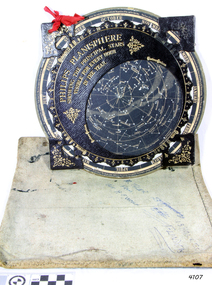
Planisphere, Early 20th Century
... This usage continued into the Renaissance: for example Gerardus Mercator described his 1569 world map as a Planisphere. The word describes the representation of the star-filled celestial sphere on the plane. ...This usage continued into the Renaissance: for example Gerardus Mercator described his 1569 world map as a Planisphere. The word describes the representation of the star-filled celestial sphere on the plane. ...The word Planisphere (Latin planisphaerium) was originally used in the second century by Claudius Ptolemy to describe the representation of a spherical Earth by a map drawn in the plane. This usage continued into the Renaissance: for example Gerardus Mercator described his 1569 world map as a Planisphere. The word describes the representation of the star-filled celestial sphere on the plane. The first star chart to have the name "Planisphere" was made in 1624 by Jacob Bartsch. Bartsch was the son-in-law of Johannes Kepler, discoverer of Kepler's laws of planetary motion. A significant item of celestial mapping used by marine navigators This particular item was made and used in the first quarter to half of the 20th centuryPlanisphere of northern hemisphere, with canvas bag. Planisphere consists of a circular star chart attached at its centre to an opaque circular overlay that has a clear elliptical window or hole so that only a portion of the sky map will be visible in the window or hole area at any given time. The chart and overlay are mounted so that they are free to rotate about a common pivot point at their centres. The star chart contains the brightest stars, constellations and (possibly) deep-sky objects visible from a particular latitude on Earth. The night sky that one sees from the Earth depends on whether the observer is in the northern or southern hemispheres and the latitude. A Planisphere window is designed for a particular latitude and will be accurate enough for a certain band either side of that. Planisphere makers will usually offer them in a number of versions for different latitudes. Planispheres only show the stars visible from the observer's latitude; stars below the horizon are not included. A complete twenty-four-hour time cycle is marked on the rim of the overlay. A full twelve months of calendar dates are marked on the rim of the starchart. The window is marked to show the direction of the eastern and western horizons. The disc and overlay are adjusted so that the observer's local time of day on the overlay corresponds to that day's date on the star chart disc. The portion of the star chart visible in the window then represents (with a distortion because it is a flat surface representing a spherical volume) the distribution of stars in the sky at that moment for the Planispheres designed location. Users hold the Planisphere above their head with the eastern and western horizons correctly aligned to match the chart to actual star positions. "Made in Germany for GEORGE PHILIP & SONS Ltd. Geographical and Educational Depot, 32 Fleet Street, London" Canvas bag has "Capt. H (Howard) Tyler from Captain H. F. Woolf" "Tyler 22 ? St East Brighton" also "13 Halls St Flinders"flagstaff hill, warrnambool, shipwrecked-coast, flagstaff-hill, flagstaff-hill-maritime-museum, maritime-museum, shipwreck-coast, flagstaff-hill-maritime-village, planisphere, star map, marine navigation, maps, george philip & sons -
 Flagstaff Hill Maritime Museum and Village
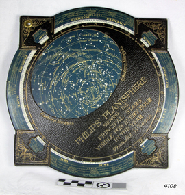
Planisphere, Early 20th Century
... This usage continued into the Renaissance: for example Gerardus Mercator described his 1569 world map as a Planisphere. The word describes the representation of the star-filled celestial sphere on the plane. ...This usage continued into the Renaissance: for example Gerardus Mercator described his 1569 world map as a Planisphere. The word describes the representation of the star-filled celestial sphere on the plane. ...The word Planisphere (Latin planisphaerium) was originally used in the second century by Claudius Ptolemy to describe the representation of a spherical Earth by a map drawn in the plane. This usage continued into the Renaissance: for example Gerardus Mercator described his 1569 world map as a Planisphere. The word describes the representation of the star-filled celestial sphere on the plane. The first star chart to have the name "Planisphere" was made in 1624 by Jacob Bartsch. Bartsch was the son-in-law of Johannes Kepler, discoverer of Kepler's laws of planetary motionA significant item of celestial mapping used by marine navigators This particular item was made and used in the first quarter to half of the 20th century.Planisphere consists of a circular star chart attached at its centre to an opaque circular overlay that has a clear elliptical window or hole so that only a portion of the sky map will be visible in the window or hole area at any given time. The chart and overlay are mounted so that they are free to rotate about a common pivot point at their centers. The star chart contains the brightest stars, constellations and (possibly) deep-sky objects visible from a particular latitude on Earth. The night sky that one sees from the Earth depends on whether the observer is in the northern or southern hemispheres and the latitude. A Planisphere window is designed for a particular latitude and will be accurate enough for a certain band either side of that. Planisphere makers will usually offer them in a number of versions for different latitudes. Planispheres only show the stars visible from the observer's latitude; stars below the horizon are not included. A complete twenty-four-hour time cycle is marked on the rim of the overlay. A full twelve months of calendar dates are marked on the rim of the star chart. The window is marked to show the direction of the eastern and western horizons. The disc and overlay are adjusted so that the observer's local time of day on the overlay corresponds to that day's date on the star chart disc. The portion of the star chart visible in the window then represents (with a distortion because it is a flat surface representing a spherical volume) the distribution of stars in the sky at that moment for the Planispheres designed location. Users hold the Planisphere above their head with the eastern and western horizons correctly aligned to match the chart to actual star positions. "Sold by J DONNE & SON, Booksellers & Stationers, 349 Post Office Place Melbourne 349. Admiralty Chart Agents" and " Made in Germany for George Philip & Son Ltd" England . Signature "Capt E. B. ?..id, 22 Baund St"flagstaff hill, warrnambool, shipwrecked-coast, flagstaff-hill, flagstaff-hill-maritime-museum, maritime-museum, shipwreck-coast, flagstaff-hill-maritime-village, star map, marine navigation, maps, george philip & sons