Showing 229 items matching " east boundary"
-
 City of Moorabbin Historical Society (Operating the Box Cottage Museum)
Photograph - Map of Dendy's Special Survey, 1852 Map of Henry Dendy's Special Survey of 1841, 19th Century
... miles south from Melbourne, bounded by North Road, East Boundary... by North Road, East Boundary Road, South Road and to the west... miles south from Melbourne, bounded by North Road, East Boundary ...A Map drawn in 1852 that shows the 5,120 acres that formed Dendy's Special Survey of 1841. In 1840 Henry Dendy, a farmer in Surrey, England acquired a "Special Survey" from the Commissioners for Land and Emigration which gave Dendy the right to choose land in Port Phillip for the "bargain basement" price of only £1 per acre for 5120 acres, (an area of 8 square miles). The Special Survey also included the right to "the shipment of a worker for every £20 spent on land, whose free passage was paid by the Crown, equalling a total of 100 workers ". Accordingly Dendy sold his English holdings and paid the required £5120 and arrived in Melbourne in February 1841. However by this time land in the new colony was selling for £5 - £40 per acre. Because Henry Dendy possessed the order from the Colonial Office in London he was able to successfully oppose Governor LaTrobe's attempts to alter the price of the land. Dendy appointed Jonathan Were, (an entrepreneur, who had arrived in 1839), as his Manager and who later became a partner. Together, Dendy and Were decided on an area 5 miles south from Melbourne, bounded by North Road, East Boundary Road, South Road and to the west by Port Phillip Bay. Were and Dendy pitched their tents in the area now known as ' Park St, Brighton' and sank a well near the corner of 'St Andrew's St and Wells St'. By 1845 J.B Were and Company had bought almost half of Dendy's land and Were built himself "Moorabbin House" in Were St Brighton made from stone, quarried from local cliffs. It was still standing in 1924. Legend records Moorabbin is named after the Aboriginal word for ' Mother's Milk ' The soil is very fertile and well supplied with water especially in the area called 'East Brighton' - now known as Bentleigh and East Bentleigh - By 1850 the area had developed with numerous market gardens, dairy farms, fruit gardens and vineyards supplying food for the growing population of Melbourne.This Map shows the birth of the Brighton and Moorabbin area. On 18th January1859 Brighton was proclaimed a Municipality and a Borough by October 1863. Meanwhile, following a Petition, the area of East and South Brighton, incorporating Mordialloc, Cheltenham, Mentone, Sandringham and Oakleigh separated from Brighton to form the Moorabbin District Roads Board becoming the first Local Government Authority. Col. William Mair was elected as the first Chairman of the Moorabbin Roads Board. Moorabbin Shire 1871 developed further and was declared a City in1934. The City of Moorabbin was the largest Municipality in Melbourne before the Amalgamation of Councils in 1994 when it was divided in the south to City of Kingston and in the north to City of Glen Eira A Photo-lithographed 1852 Map showing the 5,120 acres that formed Dendy's Special Survey of 1841. Henry Dendy & Jonathan Were chose an area 5 miles south from Melbourne, bounded by North Road, East Boundary Road, South Road and to the west by Port Phillip Bay. Moorabbin County of Bourke / Photo-Lithographed at the department of Lands and Survey. /Melbourne. / Price 1/- brighton, moorabbin, bentleigh, cheltenham, dendy henry, bent thomas, were jonathan, special survey -
 Whitehorse Historical Society Inc.
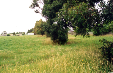
Photograph, Narmara Primary School, 13/01/1994 12:00:00 AM
... along East boundary. School on North side of Highbury Road... photo of Narmara Primary School looking North along East ...Coloured photo of Narmara Primary School looking North along East boundary. School on North side of Highbury Road between Middleborough Road and Blackburn Road. Since demolished and site developed for housing.narmara primary school, warner, philip -
 Glen Eira City Council History and Heritage Collection
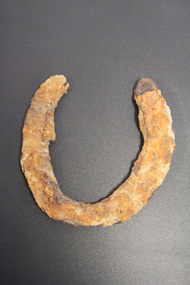
Horseshoe
... for the development of GESAC, East Boundary Road, Bentleigh. ... of GESAC, East Boundary Road, Bentleigh. No legible inscriptions ...The horseshoe was found during excavating the site for the development of GESAC, East Boundary Road, Bentleigh. Iron horseshoe, U-shaped, dark and corroded with concretion / accretion of rusty coloured debris over much of the surface.No legible inscriptions. -
 Greensborough Historical Society
Aerial Photograph, AAM Photographics, Heidelberg AAM1969c 088, 24/11/1991
... , Ivanhoe East & Viewbank. North boundary Hurstbridge railway... Eaglemont, Heidelberg, Ivanhoe East & Viewbank. North boundary ...One of a series of overlapping aerial photographs of the Heidelberg/Greensborough area, covering Eaglemont, Heidelberg, Ivanhoe East & Viewbank. North boundary Hurstbridge railway, South boundary Ivanhoe East, East boundary Bulleen RoadLaminated colour aerial photographeaglemont, heidelberg, ivanhoe east, viewbank -
 Port Melbourne Historical & Preservation Society
Photograph - Gasworks demolition, 1979
... 1. Lagoon, Esplanade East, boundary of Lagoon Reserve 2... demolition in about 1979 1. Lagoon, Esplanade East, boundary ...Six small photographs of gasworks demolition in about 1979 1. Lagoon, Esplanade East, boundary of Lagoon Reserve 2. Upright crash frame 3. Mangled cranes 4. Graham st 5. Fallen crane 6. Fallen cranebuilt environment - industrial, utilities - gas, gasworks, demolition, sandridge lagoon, lagoon reserve -
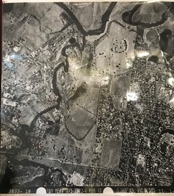
 Greensborough Historical Society
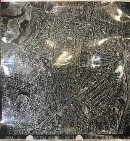
Aerial Photograph, Yan Yean M/S 7922 Run 17 No. 3833-20, 01/11/1984
... Covers Rosanna and parts of Viewbank and Heidelberg. East... of Viewbank and Heidelberg. East boundary Price Park; West boundary ...Covers Rosanna and parts of Viewbank and Heidelberg. East boundary Price Park; West boundary Hurstbridge railway lineLaminated black and white aerial photograph; adjoins 6226 on east siderosanna, viewbank, heidelberg -
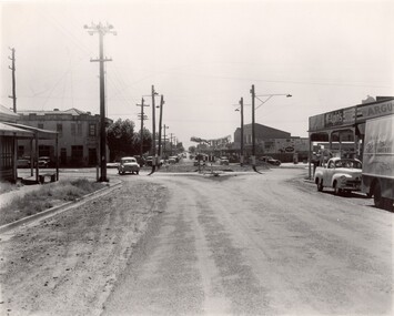 City of Kingston
Photograph - Black and white, c. 1956
... and East Boundary roads, Bentleigh East. Several cars are visible... of the intersection of Centre and East Boundary roads, Bentleigh East. Several ...Strip shopping and ample parking were features of suburbs in the middle of the twentieth centuries. Cars were still considered a luxury, although that would soon change, and local, independent shops serviced local areas.During the post-war years, the municipality of Moorabbin experienced a population boom. The 'newcomers' were predominantly returnees from the war who were marrying and establishing families; those from the old inner-suburban areas who were moving away from rented premises to establish their own homes on cheap land. The 1950s were a time of immense growth for the area now known as City of Kingston.Black and white photograph of the intersection of Centre and East Boundary roads, Bentleigh East. Several cars are visible both in the foreground and background, and the intersection includes a roundabout. The street is lined with poles to carry electricity cables, and the roundabout is dotted with four poles for electric street lights.Handwritten in blue ink: 56 - 230 Handwritten in red ink: 82% Handwritten in black ink: Ch. 6shopping strip, cars, suburbs -
 Greensborough Historical Society
Aerial Photograph, Yan Yean M/S 7922 Run 17 No. 3833-18, 1/11/1984
... boundary Yarra River & Birrarung Park; East boundary east of Plenty...; East boundary east of Plenty River viewbank Laminated black ...Covers Viewbank area: North boundary Martin's Lane; South boundary Yarra River & Birrarung Park; East boundary east of Plenty RiverLaminated black and white aerial photograph; adjoins 6227 on west sideviewbank -
 City of Kingston
Photograph - Black and white, c. 1920
... was between East Boundary and Brady Road, East Bentleigh.... was between East Boundary and Brady Road, East Bentleigh. Horse drawn ...Vic Peterson and his mother, Ida Peterson, are seated in a carriage with a horse harnessed to the front. Their property was between East Boundary and Brady Road, East Bentleigh.Black and white image of a horse and cart, with a man and woman sitting in the cart.Black ink printed on white round sticker on reverse: 335 Handwritten in red ink on reverse: 70%horse drawn wagon, east bentleigh -
 Bayside Gallery - Bayside City Council Art & Heritage Collection
Map, H.B. Foot, Plan of the Brighton Estate containing 5120 acres, first special survey at Port Phillip, c. 1842
... miles south from Melbourne, bounded by North Road, East Boundary... by North Road, South Road and East Boundary Road. The plan shows... Melbourne, bounded by North Road, East Boundary Road, South Road ...This plan records the Brighton Estate, also known as Dendy's Special Survey. In 1840 Henry Dendy, a farmer in Surrey, England acquired a "Special Survey" from the Commissioners for Land and Emigration which gave him the right to choose land in Port Phillip for the low price of £1 per acre for 5120 acres. Dendy appointed Jonathan Binns Were, as his agent, who later became a partner. Together, Dendy and Were decided on an area 5 miles south from Melbourne, bounded by North Road, East Boundary Road, South Road and to the west by Port Phillip Bay. Their Brighton Estate was first surveyed by T. S. Townsend in May 1841 and was re-surveyed by Robert Hoddle. Dendy and Were were making plans to sell the land and advertised a 30-guinea prize for the best subdivision which was to be divided into a village, marine residences, suburban and cultivation allotments, with the remainder being divided into country sections. The competition was won by H.B. Foot, who planned the village around a reserve and crescents and a 'green belt' forming the town boundary. brighton estate, dendy's special survey, special survey, henry dendy, jonathan binns were, w.b. were, survey, plan, map, brighton, george ward cole, baker's lithographer, hibernian, subdivision, town planning, cartographic material, h.b. foot -
 Greensborough Historical Society
Aerial Photograph, AAM Photographics, Heidelberg AAM1969c 106, 24/11/1991
... , Greensborough & Viewbank. North boundary Nell Street, East boundary... boundary Nell Street, East boundary Plenty River, South boundary ...One of an overlapping series of aerial photographs of the Heidelberg/Greensborough areas in 1991, covering the Simpson Barracks, Greensborough & Viewbank. North boundary Nell Street, East boundary Plenty River, South boundary Lower Plenty Road.Laminated colour aerial photographsimpson barracks, greensborough, viewbank -
 City of Kingston
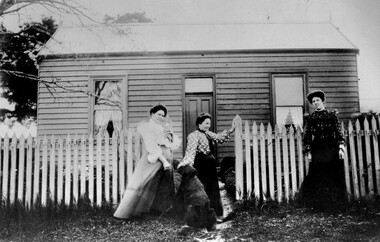
Photograph - Black and white, c. 1910
... The cottage was located on East Boundary Road, near Caleb... Parkdale The cottage was located on East Boundary Road, near Caleb ...The cottage was located on East Boundary Road, near Caleb Street in East Bentleigh. It was owned by Caleb Porter and occupied by Laura Johnson (centre). Also in the photograph are her sister Boletta Hansen Wold (left) and daughter Anna Marie Johnson (right). The dog's name has not been recordedPart of East Bentleigh was inside the original grant of land bought by English farmer and brewer, Henry Dendy, in 1841. He bought 5,120 acres (20.7 km2) which was bounded on the west by Port Phillip Bay, then North Road, East Boundary Road and South Road.Black and white image of three women and a dog standing outside a small weatherboard cottage with a picket fence. Round white sticker with black printed text: 140 Handwritten in red ink: 55%east bentleigh, caleb porter, laura johnson, boletta hansen wold, anna marie johnson -
 Kew Historical Society Inc
Legal record - The Indenture, Crown Portion 86, otherwise known as 'The Morgan Deed', 1852 (and later)
... to an alignment opposite the east boundary of Glenferrie Road... Cotham Road and High Street to an alignment opposite the east ...This indenture once formed part of the City of Kew's Municipal Collection. Cr. W.D. Vaughan in his history 'Kew's Civic Century' (1960) records on page 194 that: "The original deed of conveyance of the land being all of Crown Portion 86, Kew, purchased by John Quick, James Venn Morgan, Samuel Derrick and William Derrick was presented by the Historical Society of Victoria on behalf of Mrs Fryer, a daughter of the later J.V. Morgan, to the [Kew] Council on August 5, 1941. Crown Portion 86, comprised all the land between Cotham Road and High Street to an alignment opposite the east boundary of Glenferrie Road. On it the first residential house was built by Mr. J.V. Morgan in 1852." Following the donation, the Indenture was surrounded by other original related text and explanatory notes and framed. The resulting framed documents are the largest framed objects in the collection.The Indenture and the accompanying contextual documents are some of the most historically significant manuscripts to have survived since the settlement of Kew in the 1850s. They provide a link to Kew's most famous pioneering families.Framed 1952 Indenture recording the sale of land in Kew to pioneering Kew families.james venn morgan, john quick, william derrick, samuel derrick, kew (vic) - history, kew (vic) - pioneers, samuel watts, kew (vic.) — municipal collection -
 Ballarat Tramway Museum
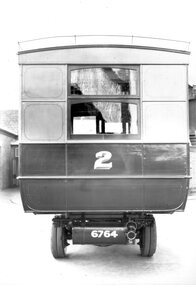
Photograph - Geelong Tramways MESCo bus No. 2
... route between the East terminus at Boundary Road and the railway... route between the East terminus at Boundary Road and the railway ...Rear of MESCo's bus No. 2, built for their East Geelong route between the East terminus at Boundary Road and the railway station or Moorabol St. wharf. Note the twin rear tyres. Looks new, 1912.Black and white print on paper.No. 1 inside a circle written on the reverse in pen. 14-2 and GRS710/14/1/2 written n the reverse in pencil.geelong tramways, mesco bus no. 2 -
 Kiewa Valley Historical Society
Map - Bogong High Plains - Grazing Runs, Grazing Run Boundaries 1960 - Soil Conservation Authority
... Feathertop in the west to Mt Nelse in the east showing physical... to Mt Nelse in the east showing physical boundaries including ...Cattle grazing on the Bogong High Plains during summer commenced in the 1840s and continued for many years. The Soil Conservation Authority recorded each family's area boundaries which were updated in June 1972 and continued to be adjusted until cattle were banned in 2005. The tradition of cattle grazing continues to be controversial.Holders of grazing rights for grazing on the Bogong High Plains were allocated specific areas recorded by the Soil Conservation Authority in 1972. Cattle have been banned in the Alpine National Park due to their impact on the environment.White paper with brown print. Bogong High Plains from Feathertop in the west to Mt Nelse in the east showing physical boundaries including the Kiewa Hydro Electric Scheme, roads, rivers and mountains. Names of families with grazing runs and the boundaries are shown.cattlemen, grazing runs, bogong high plains, kiewa valley families -
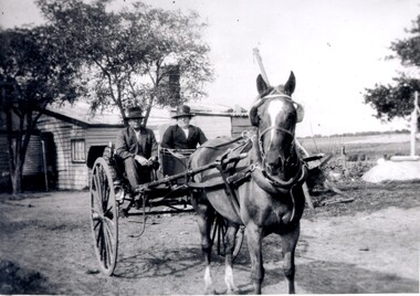
 City of Moorabbin Historical Society (Operating the Box Cottage Museum)
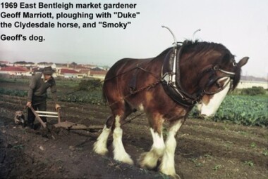
Photograph - Photograph: Horse-drawn Plough at Work, 1969 Geoff Marriott ploughing in his Market Garden, 1969
... with a four-roomed house in East Boundary Road, in the area... Boundary Road, in the area then called East Brighton. (Now known ...Members of the Marriott family arrived in Port Phillip in 1857. However it was John and Jane Marriott who in 1876, (after toiling hard since their arrival in1871, for very little gain), first leased, then purchased in 1882, 30 acres with a four-roomed house in East Boundary Road, in the area then called East Brighton. (Now known as East Bentleigh). The land they purchased had previously been a part of the 1841 Dendy Survey. Over the following years, John and his four sons with hard work and determination became prosperous vegetable growers and purchased further land in the area. Following John's retirement and subsequent death in 1903, the land was passed to his sons, and then onto the Marriott grandchildren. The family continued to remain very prosperous and successful vegetable growers. This lovely photo of Geoff Marriott bears testament to just one of the many families steeped in the tradition of vegetable growing which significantly contributed to the prosperity of the Shire, and its subsequent development into the City of Moorabbin. The photograph of Geoff Marriott of the Marriott family represents a typical example of the MANY early market gardening families, some names less prominent, but who with their labours contributed to the prosperity and the development of the community of the Shire of Moorabbin. This group of early pioneers, over many years, were a singularly important group responsible for the growth of schools, churches, the Mechanic's Hall, and were active in local government. Large coloured photograph, taken in 1969, showing Mr Geoff Marriott with his horse-drawn plough pulled by "Duke" the Clydesdale horse, and accompanied by "Smoky", his dog, working in his market garden, Brady Road, East Bentleighhorse, brighton, moorabbin, pioneers, settlers, fruit, markets, vegetables, plough, mayors, moorabbin shire, moorabbin roads board, marriott geoff, marriott john, marriott jane, market gardens, horse drawn plough, city of moorabbin -
 Federation University Historical Collection
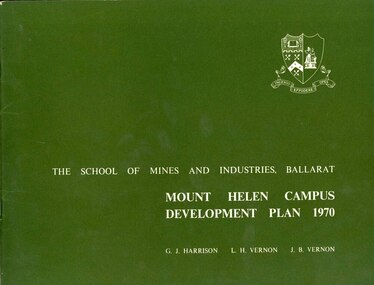
Book, Mount Helen campus Development Plan 1970, 1970
... and east boundaries are adjacent to public roads whilst the north... available is 241 acres. The west, south and east boundaries ...Green and white soft covered booklet of 48 pages. SMB Crest is on the front cover. The content include the Mt Helen site, site planning, student residences, sporting facilities, roads and parking, pedestrian circulation, engineering services, and landscaping. Illustrations include: Plan of Mt Helen Site (July 1969, existing buildings, Functional relationship, Roads and Parking, Pedestrian Circulation, engineering Services, Landscaping, Development Plan, Plan of Academic area, Library and union Courtyards, Birds Eye View of Academic Area from north-west, etc. the master plan projects student numbers.non-fictionuniversity of ballarat, ballarat institute of advanced education, mount helen, master plan, landscape, harrison, vernon, great hall, geoff harrison, john vernon, m.b. john, contour map, student accomodation, landscaping, development plan, campus plan -
 City of Moorabbin Historical Society (Operating the Box Cottage Museum)
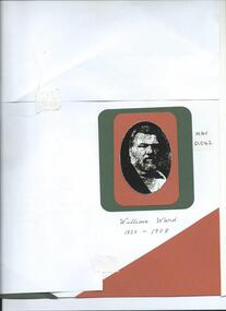
Photograph, B&W, William Ward JP Councilor, 1820 - 1908, c1880
... through out his life and when he died owned land in East Boundary... owned land in East Boundary Road, Elsternwick, and Murrumbeena ...William Ward 1820- 1908 was born in Norfolk and emigrated with his wife Ann Ostler aboard the SS Kent in 1853. The voyage took 77days. William Ward JP was a prominent figure in East Brighton . William was elected to the Moorabbin Road Board in 1863, JP at Cheltenham Court, and Shire President 1875-82. He was appointed Post Master at East Brighton in 1865 and held the position until his death in 1908. William's Municipal career extended over 30 years and the 'Southern Cross Newspaper Brighton paid him tribute in the obituary January 25th 1908. William and Anne Ward had 10 children but only 5 survived. Elizabeth Emma Ward 1963- 1921, their eldest child, married Henry Box 1839-1913 and they had 9 children but 2 died in infancy. Henry Box purchased land in Tucker Road East Brighton (Bentleigh) 1870 to establish a market garden . He continued to purchase property through out his life and when he died owned land in East Boundary Road, Elsternwick, and Murrumbeena.William Ward JP was a prominent figure in East Brighton, William was elected to the Moorabbin District Road Board in 1863, JP at Cheltenham Court, and Shire President 1875-82. He was appointed Post Master at East Brighton in 1865 and held the position until his death in 1908. William's Municipal career extended over 30 years and the 'Southern Cross Newspaper Brighton paid him tribute in the obituary January 25th 1908.A black and white photograph of William Ward JP, Councillor who was the father of Elizabeth Emma Ward the wife of Henry Box.nil -
 City of Moorabbin Historical Society (Operating the Box Cottage Museum)
Document, laminated photocopy of 'Plan of Moorabbin 1850', 1853
... easterly from the Port Phillip Bay to East Boundary Road and from... Phillip Bay to East Boundary Road and from North Road to South ...Weston Bate, 'A history of Brighton' 1962 informs us that in 1840 Henry Dendy, who was a farmer in Sussex England, paid 5,120 pounds sterling @ 1pound per acre for a 'Special Survey of Land in Port Phillip , Australia. Henry arrived in Australia in 1841 on the frigate 'York' with his wife, son, and three servants. He also took advantage of the Government Assistance of Free Immigrants for Survey Purchasers, to help on his estate and persuaded some Sussex men with their families to follow him. However when Dendy arrived in Port Phillip he found that LaTrobe and Gipps were trying to raise the price of land close to Town to 15pounds per acre. Dendy asked merchant J.B.Were to manage his affairs and they went ahead with plans to subdivide the surveyed land called 'The Brighton Estate' This area of land extended easterly from the Port Phillip Bay to East Boundary Road and from North Road to South Road in the Parish of Bourke Victoria. The Privy Council, England , decide that Henry Dendy could purchase the land at 1pound per acre. Land Sales proceeded from 1844 as more immigrants established market gardens, farms and varied businesses in 'Moorabbin'This is a photocopy of a Map of the Moorabbin , County of Bourke c1850 showing the 'Henry Dendy Special Survey 1841'A photocopy of a Map of the Moorabbin , County of Bourke c1850. A3 size laminatedLeft corner : MOORABBIN / COUNTY OF / BOURKEdendy henry, dendy special survey 1841, brighton, moorabbin, ormond, bentleigh, market gardeners, pioneers early settlers, box william, box elizabeth -
 City of Moorabbin Historical Society (Operating the Box Cottage Museum)
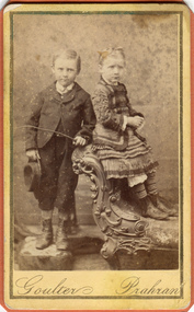
Photograph, B&W, Possibly 2 children of Heny Box 1839 -1913, c1900
... , and at his death in 1913 owned property in East Boundary Road... death in 1913 owned property in East Boundary Road, Murrumbeena ...Henry Box ,who was born in Withyham in 1839 , was the 3rd son of George and Mary Cripps Box and came to Australia in 1856 with the family. Henry paid his own fare so was not ‘bound’ to any employer. Henry helped his brother William establish his market garden on the site of Box Cottage, Jasper Road 1865 and by 1870 was purchasing property in East Brighton (Bentleigh.). He continued to purchase land, which he rent / leased to family members, and at his death in 1913 owned property in East Boundary Road, Murrumbeena and Elsternwick. Henry married Elizabeth ‘Emma’ Ward in 1868 and they had 9 children but 2 died in infancy. ‘ Emma’ was the daughter of William Ward 1820- 1908 who was born in Norfolk and emigrated with his wife Ann Ostler in 1853. Henry was a member of the Court Pride of St George AOF, and a lay preacher at the Bentleigh Baptist Church.. Surviving Children were - Caroline Alma Box 1863-1943, Mary Anne Box 1865- ?, Lydia Elizabeth Box 1867- 1957, William Henry Box 1869- 1945, Emma Elizabeth Ellen Box 1875 – 1964, Olivia Christina ‘Chrissie’ Box 1878 – 1963, Archibald Ward Box 1882 -? Box Cottage Museum, a reconstruction of an early settler hut, is named after the Box family who resided there 1865 -1913 . William Box who with his wife Elizabeth Avis Box and 13 children lived and farmed on the block of land in Jasper Road, East Brighton ( now McKinnon / Ormond) that was part of the Henry Dendy Special Survey 1841 . Henry Box, a brother of William Box, was born in Withyham, Sussex and came to Australia with his parents George and Mary Box and siblings in 1856. He purchased property and helped the family establish market gardens in East Brighton (Bentleigh). Henry and his wife Elizabeth Emma Ward Box had 9 children, Henry was a lay preacher for the Baptist Church Bentleigh. Inscribed in Album “ The early photos in this album were found by Mr (Laurie) Lewis when he was demolishing the Old Box Cottage. He gave them to Mrs Avis Box Eldridge who in turn gave them to me. They were not identified. I believe they rightly belong in the Cottage. I have attempted to identify them and present them in a way they can be preserved as a historical record of the era.” A B Leigh A black and white photograph of a young girl and boy who may be 2 of the surviving 7 children of Henry Box 1839 -1913Goulter Prahran -
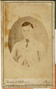
 City of Moorabbin Historical Society (Operating the Box Cottage Museum)
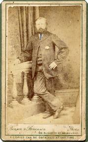
Photograph, B&W, Henry Box 1839 - 1913, c1888
... , and at his death owned property in East Boundary Road, Murrumbeena... death owned property in East Boundary Road, Murrumbeena ...Henry Box ,who was born in Withyham in 1839 , was the 3rd son of George and Mary Cripps Box and came to Australia in 1856 with the family. Henry paid his own fare so was not ‘bound’ to any employer. Henry helped his brother William establish his market garden on the site of Box Cottage, Jasper Road 1865 and by 1970 was purchasing property in East Brighton (Bentleigh.). He continued to purchase land, which he rent / leased to family members, and at his death owned property in East Boundary Road, Murrumbeena and Elsternwick. Henry married Elizabeth ‘Emma’ Ward in 1868 and they had 9 children but 2 died in infancy. ‘ Emma’ was the daughter of William Ward 1820- 1908 who was born in Norfolk and emigrated with his wife Ann Ostler in 1853. Henry was a member of the Court Pride of St George AOF, and a lay preacher at the Bentleigh Baptist Church.. Surviving Children were - Caroline Alma Box 1863-1943, Mary Anne Box 1865- ?, Lydia Elizabeth Box 1867- 1957, William Henry Box 1869- 1945, Emma Elizabeth Ellen Box 1875 – 1964, Olivia Christina ‘Chrissie’ Box 1878 – 1963, Archibald Ward Box 1882 -? Box Cottage Museum, a reconstruction of an early settler hut, is named after the Box family who resided there 1865 -1913 . William Box who with his wife Elizabeth Avis Box and 13 children lived and farmed on the block of land in Jasper Road, East Brighton ( now McKinnon / Ormond) that was part of the Henry Dendy Special Survey 1841 . Henry Box, a brother of William Box, was born in Withyham, Sussex and came to Australia with his parents George and Mary Box and siblings in 1856. He purchased property and helped the family establish market gardens in East Brighton (Bentleigh). Henry and his wife Elizabeth Emma Ward Box had 9 children, Henry was a lay preacher for the Baptist Church Bentleigh. Inscribed in Album “ The early photos in this album were found by Mr (Laurie) Lewis when he was demolishing the Old Box Cottage. He gave them to Mrs Avis Box Eldridge who in turn gave them to me. They were not identified. I believe they rightly belong in the Cottage. I have attempted to identify them and present them in a way they can be preserved as a historical record of the era.” A B Leigh A black and white photograph of Henry Box 1839 - 1913Bensen & Stevenson Photos / 108 Elizabeth St. Melbourne/ COPIES CAN BE OBTAINED AT ANY TIME -
 City of Moorabbin Historical Society (Operating the Box Cottage Museum)
Photograph, B&W, a son of Henry Box 1839 -1913, c1900
... , and at his death in 1913 owned property in East Boundary Road... death in 1913 owned property in East Boundary Road, Murrumbeena ...Henry Box ,who was born in Withyham, Sussex in 1839 , was the 3rd son of George and Mary Cripps Box and came to Australia in 1856 with the family. Henry paid his own fare so was not ‘bound’ to any employer. Henry helped his brother William establish his market garden on the site of Box Cottage, Jasper Road 1865 and by 1970 was purchasing property in East Brighton (Bentleigh.). He continued to purchase land, which he rent / leased to family members, and at his death in 1913 owned property in East Boundary Road, Murrumbeena and Elsternwick. Henry married Elizabeth ‘Emma’ Ward in 1868 and they had 9 children but 2 died in infancy. ‘ Emma’ was the daughter of William Ward 1820- 1908 who was born in Norfolk and emigrated with his wife Ann Ostler in 1853. Henry was a member of the Court Pride of St George AOF, and a lay preacher at the Bentleigh Baptist Church.. Surviving Children were - Caroline Alma Box 1863-1943, Mary Anne Box 1865- ?, Lydia Elizabeth Box 1867- 1957, William Henry Box 1869- 1945, Emma Elizabeth Ellen Box 1875 – 1964, Olivia Christina ‘Chrissie’ Box 1878 – 1963, Archibald Ward Box 1882 -? Box Cottage Museum, a reconstruction of an early settler hut, is named after the Box family who resided there 1865 -1913 . William Box who with his wife Elizabeth Avis Box and 13 children lived and farmed on the block of land in Jasper Road, East Brighton ( now McKinnon / Ormond) that was part of the Henry Dendy Special Survey 1841 . Henry Box, a brother of William Box, was born in Withyham, Sussex and came to Australia with his parents George and Mary Box and siblings in 1856. He purchased property and helped the family establish market gardens in East Brighton (Bentleigh). Henry and his wife Elizabeth Emma Ward Box had 9 children, Henry was a lay preacher for the Baptist Church Bentleigh. Inscribed in Album “ The early photos in this album were found by Mr (Laurie) Lewis when he was demolishing the Old Box Cottage. He gave them to Mrs Avis Box Eldridge who in turn gave them to me. They were not identified. I believe they rightly belong in the Cottage. I have attempted to identify them and present them in a way they can be preserved as a historical record of the era.” A B Leigh A black and white photograph of a boy who could be a son of Henry Box 1839 -1913BENSEN & STEVENSON PHOTOS / 108 Elizabeth Street Melbourne/ COPIES CAN BE OBTAINED AT ANY TIME -
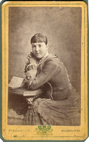 City of Moorabbin Historical Society (Operating the Box Cottage Museum)
Photograph, B&W, possibly Elizabeth Emma Ward wife of Henry Box, 1880
... , and at his death owned property in East Boundary Road, Murrumbeena... death owned property in East Boundary Road, Murrumbeena ...Henry Box ,who was born in Withyham in 1839 , was the 3rd son of George and Mary Cripps Box and came to Australia in 1856 with the family. Henry paid his own fare so was not ‘bound’ to any employer. Henry helped his brother William establish his market garden on the site of Box Cottage, Jasper Road 1865 and by 1970 was purchasing property in East Brighton (Bentleigh.). He continued to purchase land, which he rent / leased to family members, and at his death owned property in East Boundary Road, Murrumbeena and Elsternwick. Henry married Elizabeth ‘Emma’ Ward in 1868 and they had 9 children but 2 died in infancy. ‘ Emma’ was the daughter of William Ward 1820- 1908 who was born in Norfolk and emigrated with his wife Ann Ostler in 1853. William Ward JP was a prominent figure in East Brighton . William was elected to the Moorabbin Road Board in 1863, JP at Cheltenham Court, and Shire President 1875-82. He was appointed Post Master at East Brighton in 1865 and held the position until his death in 1908 Henry was a member of the Court Pride of St George AOF, and a lay preacher at the Bentleigh Baptist Church.. Surviving Children were - Caroline Alma Box 1863-1943, Mary Anne Box 1865- ?, Lydia Elizabeth Box 1867- 1957, William Henry Box 1869- 1945, Emma Elizabeth Ellen Box 1875 – 1964, Olivia Christina ‘Chrissie’ Box 1878 – 1963, Archibald Ward Box 1882 -? Box Cottage Museum, a reconstruction of an early settler hut, is named after the Box family who resided there 1865 -1913 . William Box who with his wife Elizabeth Avis Box and 13 children lived and farmed on the block of land in Jasper Road, East Brighton ( now McKinnon / Ormond) that was part of the Henry Dendy Special Survey 1841 . Henry Box, a brother of William Box, was born in Withyham, Sussex and came to Australia with his parents George and Mary Box and siblings in 1856. He purchased property and helped the family establish market gardens in East Brighton (Bentleigh). Henry and his wife Elizabeth Emma Ward Box had 9 children, Henry was a lay preacher for the Baptist Church Bentleigh. Inscribed in Album “ The early photos in this album were found by Mr (Laurie) Lewis when he was demolishing the Old Box Cottage. He gave them to Mrs Avis Box Eldridge who in turn gave them to me. They were not identified. I believe they rightly belong in the Cottage. I have attempted to identify them and present them in a way they can be preserved as a historical record of the era.” A B Leigh A black and white photograph of a young woman who may be Elizabeth Emma Ward 1863 - 1921,the wife of Henry Box.1839-1913Stewart & Co ' Coat of Arms" Melbourne -
 City of Moorabbin Historical Society (Operating the Box Cottage Museum)
Photographs,x3 Colour Early Weatherboard Cottage Cheltenham c1880, 1981
... ' that extended from Brighton bayside North Road, East Boundary Rd... Brighton bayside North Road, East Boundary Rd to South Road ...Henry Dendy , a farmer from Sussex England, purchased 5,120 acres of land in the area of a 'Special Survey 1841' that extended from Brighton bayside North Road, East Boundary Rd to South Road. This area became known as Dendy's Brighton and as part of the sale 139 emigrant workers arrived in 1842 however Dendy was unable to find work and lodgings for these people. J.B.Were, financier took over the management of the 'Special Survey 1841' area and began to sell and lease allotments. 1850 the Squatter King brothers sold land south of Dendy's 'Special Survey 1841' to Josiah Holloway who sectioned it into 2 acre lots @ £10 each for market gardens - 'Two Acre Village' and Charles Whorral opened a small hotel - 'The Cheltenham Inn' on the main Road - Arthur's Seat Rd, later Point Nepean Rd, now Nepean Highway. Notable settlers who moved into the area were Keys, Charman, Bruton, Le Page, Fairlam, Meeres and 1862 saw the separation from Brighton and the formation of the Mooorabbin Roads Board District. .By 1879 1000settlers were living in 'Cheltenham' serviced by a Post Office with Bank, Mechanics Institute, State School No 84,Keys Hotel, Meeres Store, Sir Thomas Bent ensured the new Railway Line from Caulfield to Mordialloc went through his constituency of Cheltenham 1881 and this changed the development to the bayside area of Cheltenham away from the 'Two Acre Village ' side causing some dissention, However Cheltenham as whole prospered and this house in Pine St is typical of the cottages built c 1890- 1900 in the area. This weatherboard house c 1890-1900 in Pine St Cheltenham is typical of those built for early settler families. Photo taken 1981 by CMHS member 3 x Colour photographs of an early c 1900 weatherboard house in Pine St Cheltenham taken by CMHS member 1981Kodak Aug. 81 / Handwritten Pine St Cheltenhamkeys robert, holloway josiah, king brothers, smith j l; smith mary ann, stanley helen, chaff cutter, horse drawn carts, toll gates brighton, motor cars 1900, steam engines, early settlers, bentleigh, parish of moorabbin, city of moorabbin, county of bourke, moorabbin roads board, shire of moorabbin, henry dendy's special survey 1841, were j.b.; bent thomas, o'shannassy john, king richard, charman stephen, highett william, ormond francis, maynard dennis, market gardeners, vineyards, orchards -
 City of Moorabbin Historical Society (Operating the Box Cottage Museum)
Document - Genealogy Chart Henry Dendy (Photocopy), 19 thC
... Melbourne, bounded by North Road, East Boundary Road, South Road... Road, East Boundary Road, South Road and to the west by Port ...In 1840 Henry Dendy, a farmer in Surrey, England acquired a "Special Survey" from the Commissioners for Land and Emigration which gave Dendy the right to choose land in Port Phillip for the "bargain basement" price of only £1 per acre for 5120 acres, (an area of 8 square miles). The Special Survey also included the right to "the shipment of a worker for every £20 spent on land, whose free passage was paid by the Crown, equalling a total of 100 workers ". Accordingly Dendy sold his English holdings and paid the required £5120 and arrived in Melbourne in February 1841. However by this time land in the new colony was selling for £5 - £40 per acre. Because Henry Dendy possessed the order from the Colonial Office in London he was able to successfully oppose Super-intendant LaTrobe's attempts to alter the price of the land. Dendy appointed Jonathan Were, (an entrepreneur, who had arrived in 1839), as his Manager and who later became a partner. Together, Dendy and Were decided on an area 5 miles south from Melbourne, bounded by North Road, East Boundary Road, South Road and to the west by Port Phillip Bay. Were and Dendy pitched their tents in the area now known as ' Park St, Brighton' and sank a well near the corner of 'St Andrew's St and Wells St'. By 1845 J.B Were and Company had bought almost half of Dendy's land and Were built himself "Moorabbin House" in Were St Brighton made from stone, quarried from local cliffs. It was still standing in 1924. Legend records Moorabbin is named after the Aboriginal word for ' Mother's Milk ' The soil is very fertile and well supplied with water especially in the area called 'East Brighton' - now known as Bentleigh and East Bentleigh - By 1850 the area had developed with numerous market gardens, dairy farms, fruit gardens and vineyards supplying food for the growing population of Melbourne.In 1840 Henry Dendy, a farmer in Surrey, England acquired a "Special Survey" from the Commissioners for Land and Emigration which gave Dendy the right to choose land in Port Phillip for the price of only £1 per acre for 5120 acres. This land was called Brighton in the Parish of Moorabbin, County of Bourke and emigrants developed the land establishing market gardens , dairy and poultry farms that provided the food for the growing population of Melbourne. A photocopy of the Genealogy Chart of the Dendy Family that Henry Dendy brought with him when he emigrated to Melbourne 1841Genealogy signs and descriptionsdendy henry, dendy's special survey brighton 1841, governor gipps, captain lonsdale, super-intendant latrobe, port phillip, melbourne, new south wales, squatters, emmigrants, county of bourke, parish of moorabbin, early settlers, pioneers, market gardeners, dairy farmers, fruit farms, moorabbin, bentleigh, brighton, cheltenham, were jonathan binn, -
City of Moorabbin Historical Society (Operating the Box Cottage Museum)
Document, Henry Dendy family Shield
... Melbourne, bounded by North Road, East Boundary Road, South Road... Road, East Boundary Road, South Road and to the west by Port ...In 1840 Henry Dendy, a farmer in Surrey, England acquired a "Special Survey" from the Commissioners for Land and Emigration which gave Dendy the right to choose land in Port Phillip for the "bargain basement" price of only £1 per acre for 5120 acres, (an area of 8 square miles). The Special Survey also included the right to "the shipment of a worker for every £20 spent on land, whose free passage was paid by the Crown, equalling a total of 100 workers ". Accordingly Dendy sold his English holdings and paid the required £5120 and arrived in Melbourne in February 1841. However by this time land in the new colony was selling for £5 - £40 per acre. Because Henry Dendy possessed the order from the Colonial Office in London he was able to successfully oppose Super-intendant LaTrobe's attempts to alter the price of the land. Dendy appointed Jonathan Were, (an entrepreneur, who had arrived in 1839), as his Manager and who later became a partner. Together, Dendy and Were decided on an area 5 miles south from Melbourne, bounded by North Road, East Boundary Road, South Road and to the west by Port Phillip Bay. Were and Dendy pitched their tents in the area now known as ' Park St, Brighton' and sank a well near the corner of 'St Andrew's St and Wells St'. By 1845 J.B Were and Company had bought almost half of Dendy's land and Were built himself "Moorabbin House" in Were St Brighton made from stone, quarried from local cliffs. It was still standing in 1924. Legend records Moorabbin is named after the Aboriginal word for ' Mother's Milk ' The soil is very fertile and well supplied with water especially in the area called 'East Brighton' - now known as Bentleigh and East Bentleigh - By 1850 the area had developed with numerous market gardens, dairy farms, fruit gardens and vineyards supplying food for the growing population of Melbourne. dendy henry, dendy's special survey brighton 1841, governor gipps, captain lonsdale, super-intendant latrobe, port phillip, melbourne, new south wales, squatters, emmigrants, county of bourke, parish of moorabbin, early settlers, pioneers, market gardeners, dairy farmers, fruit farms, moorabbin, bentleigh, brighton, cheltenham, were jonathan binn, -
 City of Moorabbin Historical Society (Operating the Box Cottage Museum)
Document - Pedigree of Henry Dendy, c1840 Original ; Copy 1985
... Melbourne, bounded by North Road, East Boundary Road, South Road... Melbourne, bounded by North Road, East Boundary Road, South Road ...This is a copy of the document brought by Henry Dendy to the Colony in 1841. In 1840 Henry Dendy, a farmer in Surrey, England acquired a "Special Survey" from the Commissioners for Land and Emigration which gave Dendy the right to choose land in Port Phillip for the "bargain basement" price of only £1 per acre for 5120 acres, (an area of 8 square miles). The Special Survey also included the right to "the shipment of a worker for every £20 spent on land, whose free passage was paid by the Crown, equalling a total of 100 workers ". Accordingly Dendy sold his English holdings and paid the required £5120 and arrived in Melbourne in February 1841. However by this time land in the new colony was selling for £5 - £40 per acre. Because Henry Dendy possessed the order from the Colonial Office in London he was able to successfully oppose Super-intendant LaTrobe's attempts to alter the price of the land. Dendy appointed Jonathan Were, (an entrepreneur, who had arrived in 1839), as his Manager and who later became a partner. Together, Dendy and Were decided on an area 5 miles south from Melbourne, bounded by North Road, East Boundary Road, South Road and to the west by Port Phillip Bay. Were and Dendy pitched their tents in the area now known as ' Park St, Brighton' and sank a well near the corner of 'St Andrew's St and Wells St'. By 1845 J.B Were and Company had bought almost half of Dendy's land and Were built himself "Moorabbin House" in Were St Brighton made from stone, quarried from local cliffs. It was still standing in 1924. Legend records Moorabbin is named after the Aboriginal word for ' Mother's Milk ' The soil is very fertile and well supplied with water especially in the area called 'East Brighton' - now known as Bentleigh and East Bentleigh - By 1850 the area had developed with numerous market gardens, dairy farms, fruit gardens and vineyards supplying food for the growing population of Melbourne. A copy of a paper chart of the Pedigree of Henry Dendy in a wooden frame with glassPedigree / of the branch of the family / DENDY moorabbin, brighton, henry dend special survey 1841 y, early settlers, pioneers, market gardeners -
 Glen Eira Historical Society
Album - Album page, Booran Road, 30, Circa 1972
... Robertson. The property had extensive wood stables on its north-east... Robertson. The property had extensive wood stables on its north-east ...This photograph is part of the Caulfield Historical Album 1972. This album was created in approximately 1972 as part of a project by the Caulfield Historical Society to assist in identifying buildings worthy of preservation. The album is related to a Survey the Caulfield Historical Society developed in collaboration with the National Trust of Australia (Victoria) and Caulfield City Council to identify historic buildings within the City of Caulfield that warranted the protection of a National Trust Classification. Principal photographer thought to be Trevor Hart, member of Caulfield Historical Society. Most photographs were taken between 1966-1972 with a small number of photographs being older and from unknown sources. All photographs are black and white except where stated, with 386 photographs over 198 pages. From Glen Eira Heritage Management Plan 1996 by Andrew Ward: In 1888, John Leek, a trainer, owned Lot 15, measuring one and three quarter acres, in Booran Road, north side between Glen Eira and Neerim Roads. The land backed onto the Caulfield Racecourse Reserve. NAV was £45. In 1890 Leek built for his residence, a ten roomed brick house on the site. NAV was £200. Leek was the owner/trainer of "Ingliston" who won the Caulfield Cup in 1900. Upon the horse's death in 1901, Leek is understood to have defied tradition by spending £20 on boots for the "ragged urchins in Bourke Street" instead of "shouting" at the bar. By 1899, the property was owned and occupied by Alfred Merrill, a dentist and was known as "Andover". NA V had decreased to £ll0. By 1910, Leslie Macdonald, a gentleman had purchased the property and renamed it "Moidart". In 1910-11 Macdonald sold it to John Robertson. The property had extensive wood stables on its north-east boundary and several other outbuildings. The house continued to be described as "Brick, ten rooms" as it was in 1926 when it was owned and occupied by John Arthur, a managing director. The land measured la.2r.31p. and had a NAV of £235. Nine people lived there. In 1926, Arthur also owned the adjoining Lot 16. Other racehorses of note, known to have been stabled here include Sobar, Havelock, Proud, Future and Lord.Victorian Heritage Register https://vhd.heritagecouncil.vic.gov.au/places/13532 What is significant? Lord Lodge is a thoroughbred racehorse training complex adjacent to Caulfield Racecourse, established in 1890. The area immediately around the racecourse has been associated with horse racing activities and businesses servicing the industry since the development of the racecourse in late the 19th century. Lord Lodge was named by the present occupants after the champion racehorse Lord who was stabled there in the 1950s. In the early 20th century the property was known as 'Andover' and subsequently 'Moidart'. The site consists of a single storey brick Italianate villa, jockeys' quarters, stables and open day yards with direct access to Caulfield racecourse from the rear of the property. The villa of 10 rooms on bluestone foundations was constructed in 1890 by John Leek, a horse trainer who purchased the newly subdivided land in 1888. The house has many Victorian Italianate or Boom Style features although it is more modest than many villas of its style. It has an asymmetrical facade with a faceted bay window and a prominent central tower with low pitch pyramidal roof that provides a clear view of the racecourse. Other characteristic features include stilted segmented arches, bracketed eaves, stucco wall finish and cast cement ornamentation. A room has been added on the north-facing verandah in sympathetic style and finish. Internally the rooms are substantially intact with original marble fireplaces and intricate ceiling roses and cornices. An entrance toward the rear of the southern side of the house is said to be where the stable hands, jockeys and other staff lined up for their meals. In the southeast corner of the property, backing directly on to Caulfield racecourse, is a substantial late Victorian timber stable, probably constructed in the 1890s but first appearing on the property title in 1910. The stable has 12 stalls, a loft and brick pavement and jerkin head roof form with varnished pine-lined ceiling carried on a chamfered timber frame. It has an original roof lantern. The doors of the stalls are not the original sliding doors but swing doors obtained from a barn at Epsom Racecourse in Mordialloc prior to demolition. Outside the gambrel roof has fretted barges but the building is otherwise utilitarian. Timber throughout the stalls has been worn by chewing and rubbing of horses over the century of its use. In the southern half of the property are open day yards where the racehorses are kept during the day. The red brick, single storey jockeys' quarters to the rear of the villa were probably built around 1950. A small brick, possibly late Victorian structure on the eastern boundary thought to have originally been a gardening shed, has been converted to a stable of two stalls. Modern concrete brick stables fill the northeast portion of the property. At the front of the property two Moreton Bay Figs (Ficus macrophylla), probably planted in the late 19th century, provide shade for horses in the day yards. In the 1890s John Leek sold the property, relocating his training facility to one of the newly established racecourses at Mentone or Mordialloc (Epsom). By 1899, the property was owned and occupied by Alfred Merrill, a dentist, who named the property 'Andover'. In 1910 it was purchased by Leslie McDonald, a gentleman, and renamed 'Moidart'; sold in 1910-1911 to John Robertson; and again in 1926 to John Arthur, a racehorse owner. The Victorian Amateur Turf Club purchased the property in the late 1930s and since this time has been leased to racehorse trainers. It is unclear whether the property operated as a training facility between 1899 - 1926. Several notable trainers and jockeys are associated with Lord Lodge. The best known is Arthur 'Scobie' Breasley, Australia's most successful jockey who was apprenticed to trainer Pat Quinlan at Lord Lodge (then 'Moidart') from 1928 - 1935. Breasley rode winners of the Caulfield Cup in four successive years 1942-45 and again in 1952. John Leek, the original owner of Lord Lodge trained Ingliston, the 1900 Caulfield Cup winner. Along with 'Lord' a number of well known racehorses including Sobar, Havelock, Proud and Future were trained at Lord Lodge .....Page 40 of Photograph Album with three landscape photographs of the exterior of this house.Handwritten: 30 Booran Road [top right hand corner] / 40 [bottom right]trevor hart, jenny o'donnell, booran road, mansion, caulfield east, ingliston, sobar, havelock, proud, future, lord, andover, moidart, lord lodge, grace darling, caulfield racecourse reserve, victorian amateur turf club, historic buildings register, national estate register, caulfield cup, horses, stables, horse racing, racehorses, outbuildings, racehorse trainers, depression, 1890s, brick houses, mansions, towers, verandahs, stained glass, italianate style, victorian style, architectural features, architectural styles, john leek, leslie macdonald, john arthur, john robertson, alfred merrill, jenny odonnell -
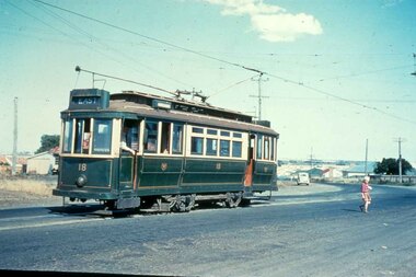 Ballarat Tramway Museum
Slide - 35mm slide/s, mid 1950's
... Pengelley No. 18 at East Terminus Ormond and Boundary Roads. Photo... at the time. Tramways trams Geelong East Closure Last Day tram 18 "G ...Yields information about the Geelong tramway system and one of the terminus and the appearance at the time.Agfachrome Professional plastic mount (blue base, white cover) reproduction slide of a colour slide of Geelong Pengelley No. 18 at East Terminus Ormond and Boundary Roads. Photo shows a child walking away from the tram. Tram has the destination of East. Photographer unknown. Taken on the last day of the first closures, 8/1/1956. See also Reg Item 4389 for a print of this slide. "G 16" and "1 -16" in pencil.tramways, trams, geelong, east, closure, last day, tram 18 -
Port Melbourne Historical & Preservation Society
Photograph - Photograph board, Seven aerial views of J Kitchen & Sons site, Port Melbourne, J Kitchen & Sons Pty Ltd. Port Melbourne 1951, 1951
... pasted on it. Taken in 1951. Photo 1 - South East direction... photographs pasted on it. Taken in 1951. Photo 1 - South East ...Large brown cardboard with seven (7) B&W aerial photographs pasted on it. Taken in 1951. Photo 1 - South East direction with Boundary Street in foreground, Kitchens buildings and Football Ground (cricket being played) Photo 2 - South West direction towards the Bay showing Station and Princes Piers, with ships in the distance. Photo 3 - almost directly above Kitchens Photo 4 - directly above kitchens Photo 5 - looking West including the Yarra River Photo 6 - looking North with Kitchen's storage and football ground in foreground Photo 7 - looking north east with football ground in foregrpound left and Yarra River top right.industry - manufacturing, built environment - industrial, piers and wharves - princes pier, piers and wharves - station pier, sport - australian rules football, sport - cricket, sport - recreational grounds, j kitchen & sons pty ltd, port melbourne football and cricket ground, north port oval