Showing 427 items
matching land's department
-
 Orbost & District Historical Society
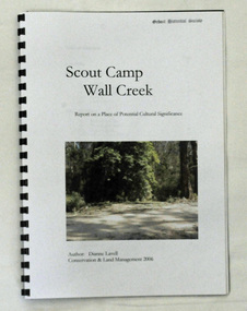
book, Scout Camp Wall Creek, 2006
... for the Department of Conservation and Land Management in Orbost. She...Department of Conservation and Land Management... for the Department of Conservation and Land Management. Dianne Lavell worked ...This report was written by Dianne Lavell for the Department of Conservation and Land Management. Dianne Lavell worked for the Department of Conservation and Land Management in Orbost. She was a long time resident of Orbost. A spiral bound, plastic covered book titled Scout Camp Wall Creek. It is a report on Scout Camp at Wall Creek in Orbost. It contains description and history of the site deemed to be a place of potential cultural significance. on the front cover is a coloured photo of the site.scout-camp-wall-creek -
 Orbost & District Historical Society
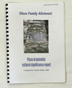
book, Close Family Allotment, 2006
... for the Department of Conservation and Land Management, Victoria. Martin...Department of Conservation and Land Management... for the Department of Conservation and Land Management, Victoria. Martin ...This report was compiled by Martin Healey for the Department of Conservation and Land Management, Victoria. Martin Healey, a long time Orbost resident, worked for the Department of Conservation and Land Management in Orbost.This is a useful research tool.A small spiral bound book of 30 pp with a plastic cover. It is a report written by Martin Healey and details the close Family allotments at Murrangower, east of Orbost. -
 The Beechworth Burke Museum
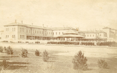
Photograph, Bayless C. - Manager, 1875
In this photo, taken in around 1875, is depicted the exterior of the Beechworth Mental Asylum buildings, with the administration buildings far right of the photo. A sunken boundary wall in the foreground and some people in view, sitting at the pavillion in the centre of the image. The two-storey buildings, designed in Italianate style, and the three-storey towers at the front, influenced by the asylum at Colney Hatch in England. The architecture of the buildings shares key features with other contemporary institutions, like Aradale at Ararat, and its design is attributed to the Public Works Department architect, J.J. Clark, whose name is connected with the construction of many other important public buildings, such as the Asylums at Kew and Ararat, the front block of the Royal Mint, Melbourne and the Melbourne Customs House. The Mayday Hills Hospital was constructed between 1864 and 1867, with buildings created in a number of periods. It formally opened on 24 October 1867 and, along with the Ovens Hospital and the Benevolent Asylum, made Beechworth a prominent social welfare centre in Victoria. Large masses of granite were excavated for its foundation and around 250 workmen were employed for its construction. The building, divided into six sections, was comprised of dormitories, doctors` rooms and plenty ancillary rooms and facilities, such as laundries, reading rooms, a concert hall and cooking areas. The site was chosen for its panoramic view of the countryside, the hilltop atmosphere and the native fauna, all contributing to the cure of patients. The Hospital was originally named the “Ovens Lunatic Asylum” but during the centenary celebrations in 1967 the name was officially changed to “Mayday Hills Hospital”, showing the gradual shift in the perception and understanding of mental health conditions over the last decades. The Hospital lies on the traditional land of the Kulin Nation.This photograph is historically significant as it provides an insight into the location, surroundings and the exterior of the Mayday Hills Hospital at the end of the 19th century. It also contributes to the understanding of the district`s development and its importance to the course of Victoria`s history and is acknowledged as a unique construction, being one of three identified as the largest of their kind.Black and white rectangular photograph printed on matte photographic paper mounted on board.Reverse: 37/ 3443/ Beechworth Asylum about 1875/ American & Australasian/Photographic Company/Victoria Branch./C.Bayless, Manager./ No./beechworth mental asylum, aradale, public works department, j.j. clark, melbourne customs house, colney hatch, italianate style, mayday hills hospital, royal mint, granite, benevolent asylum, dormitories, ovens lunatic asylum, ancillary rooms, centenary celebrations, three-storey towers, countryside, mental health conditions, kulin nation, concert hall -
 Ballan Shire Historical Society
Map - Map. Bungal, Department of Lands and Survey, Bungal, County of Grant, 09/09/1926
A map of Bungal in the 1920's showing the allotments, and the size, with the names of the residents. It shows the roads and the Western and Eastern Moorarbool River, and the Whipstick State Forest.Cream coloured map of Bungal in the County of Grant, bounded by the the East Moorarbool River on the East, and the State Forest on the South. It is marked with the scale of chains and the number L.358. Lithographed at the Department of Lands and Survey. Melbourne by W. J. Butson on 9.9.1926. It shows the land allotments with names of owners.Coloured pen marks and circled numbers on various areas. Price 2 shillings marked on bottom right hand edge.bungal, kerrit bareet, egerton, lal lal, borhoneyghurk, bungeeltap, ballark, yaloak, gorong, moorarbool west -
 Ballan Shire Historical Society
Map - Map. Kerrit Bareet, Department of Lands and Survey, Kerrit Bareet. County of Grant, 08/1944
A map of the Kerrit Bareet area within the County of Grant showing properties and names of owners in 1944.Significant to people researching land usage and ownership. Also those researching families in the area at that time.A map of Kerrit Bareet in the County of Grant. Black printing on buff coloured paper. Details roads, rivers, railways, property boundaries and names of property owners and towns and villages. The map is easily readable although there is some physical damage and that and the borders have been reinforced with sellotape. Shows a Scale in Chains and Price 2/.gordon, bungal, kerrit bareet, lal lal, moorarbool river, warrenheip, bungaree, wallace, moorarbool west -
 Ballan Shire Historical Society
Map - Map. Korweinguboora, Department of Lands and Survey, Korweinguboora. Counties of Talbot and Grant
A map of the Korweinguboora area showing roads, forests, railway lines and properties with the owners names.The inclusion of the names of landowners is of significance and value to historians.A map of the Korweinguboora area showing land subdivisions and names of owners and other physical features. There is a scale in chains. No date is certain but it could be 1902. The map has been repaired with sellotape.There are various pencil annotations but the are difficult to read.talbot, moorarbool west, wombat, bullarto, korweinguboora, moorarbool east, dean, wombat state forest, barkstead -
 Ringwood and District Historical Society
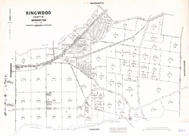
Map - Parish of Ringwood, County of Mornington, Victoria, Original Land Owners
Laminated Parish map of Ringwood detailing original Land Owners' names, property locations and acreages. Details reproduced in 1957 by the Department of Lands and Survey, Melbourne, from original surveys of varying dates. -
 Ringwood and District Historical Society
Land Title, Land Department, Titles, Maps: George Thomas Wiggin. Near Cnr Whitehorse Rd and New St Ringwood. 1917-1953
... Land Department... Ringwood. 1917-1953 Land Title Land Department ...7 photocopied pages of land area maps and titles showing names of owners from 1917 to 1953 - copied in 2004 +Additional Keywords: Wiggin, George Thomas -
Ringwood and District Historical Society
Plastic packet, PTC - Maroondah City Council, Public Transport Commission, Ringwood Railway Station Development Study, Interchange Upgrade, Community Workshops - various printed documents 1995-2013, 1995 to 2013
The urban consulting group commissioned Maroondah City Council and the Public Transport Feasibility Study, Ringwood Railway Station to be upgraded October 1995Various printed documents relating to PTC (Public Transport Commission), Maroondah City Council, Department of Transport - Ringwood Railway Station Redevelopment Study October 1995, Ringwood Station Bus interchange upgrade, designing new look Ringwood Station. Workshops were held for the community. +Additional Keywords: Ringwood Station Bus Interchange upgrade feed back sheet October 2011 / Ringwood Station Precinct Redevelopment Workshop held 26 July 2011 / Ringwood Station and bus upgrade December 2011 / Ringwood Town Centre South Project / Precinct Plans Planning Report. / Ringwood Town Centre Draft Report November 2000 / Ringwood Activities Community Newsletter August 2011 - Ringwood Station Update / State Government to sell Central Ringwood Railway land - Herald Sun 30 December 2013 / Ringwood Town Centre Precinct 4 Station Superblock for Railway Station July 2009 / Media release $66m station 15 April 2015 / Ringwood Station and Interchange Upgrade, Wednesday 27 August 2014 / Lifts left off upgrade plan - Leader Community Paper, 10 December 2013 / How to submit your feedback - Ringwood Station Precinct proposed concept, December 2011 / Designing a new look Ringwood Station workshop handout / State Government announces $66 million redevelopment of Ringwood Train Station, Herald Sun 6 June 2013 / Ringwood Station and bus interchange upgrade project update July 2012 / Set Concept design plans of $66 million Ringwood Railway Station over the years / Set photos of Ringwood Station taken between 2004 to 2005 / A3 drawing - Plan of Ringwood Station / A3 drawing - Ringwood Station proposed layout / A3 drawing - Old Station, Ringwood / A3 drawing - Proposed plan 2011 / A4 drawing - Final plan of Ringwood Station 2014 / A4 drawing - Proposed plan 2010 Ringwood Railway Station / A3 drawing - Proposed plan Ringwood Station with bridge across Maroondah Highway -
 Ringwood and District Historical Society
Pamphlet, Subdivisional Auction Sale, Bedford Park, Ringwood - 1924
Bedford Park subdivisional development did not eventuate. The land adjoining the railway line became parkland with provision for sporting facilities and the remainder was purchased by the Education Department as the site for Ringwood High School/Secondary College. Double sided bifolded auction sale advertisement including subdivision features and local facilitiesSubdivision plan includes Bedford Road, Graham Road, Joyce Street, Anderson Street, and Adams Street -
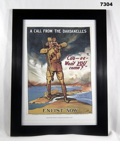 Bendigo Military Museum
Print - PRINT, FRAMED WW1, Reader's Digest (Australia) Pty Limited, 2015
From information book- "Reader's Digest/ Gallipoli/ 25th April 1915 - 9th January 1916/ Centenary Commemorative Prints". Collection of 20 prints. Refer Cat No 7300.Framed print. Print - colour print on paper. Copy of a "chromolithograph on canvas" poster. Depicts a strong soldier wearing a slouch hat standing astride a 3D land area and peninsula. "The soldier has raised his hands to his mouth". Frame - black plastic framing with glass front and MDF board backing with adhered black paper.Details below print - in black ink, "RECRUITING POSTER, A Call from the Dardanelles, 1915". Details on poster. "A CALL FROM THE DARDANELLES/ "COO-EE"/ Won't YOU come? "/ ENLIST NOW/ Issued by Authority of THE DEFENCE DEPARTMENT OF COMMONWEALTH - S.T. LEIGH & CO. LTD, LITHOGRAPHIC PRINTERS, SYDNEY".framed accessories, pprints, ww1, gallipoli, centenary -
 Warrnambool and District Historical Society Inc.
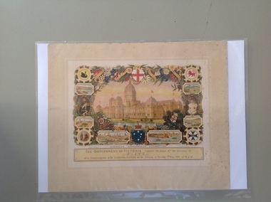
Certificate - Federation Celebration Rolfe invitation, 1901
This invitation to a ‘Conversazione’ to celebrate the Federation of the six colonies in Australia into the six States of Australia in 1901 was sent to the invitees after the event to keep as a souvenir of the occasion. The event was hosted by the Government of Victoria. The certificate was designed by George Brougham Austin, a Melbourne architect and artist employed by the Victorian Department of Public Works. He also designed many of the public decorations displayed in Melbourne during the Federation celebrations. Austin’s original work was lithographed by an artist at Sands and McDougall, Melbourne. This particular invitation was sent to George Rolfe and his wife, Annie. George Rolfe (1836-1919), a tea merchant from Melbourne, began buying blocks of land near the mouth of the Hopkins River in Warrnambool in the 1870s. By the early 1880s he owned 50 acres of land in the town and some nearby farming properties. He used the building on the ]and near the mouth of the Hopkins River as holiday accommodation and called the property, Lyndoch. He improved the property with the additions of stables, jetty, boathouse, bone and chaff sheds, reservoir and windmill and extensive gardens. Rolfe spent most of his later life at Lyndoch. Today the property is the site of an Aged Care facility. This certificate is of considerable importance for two reasons: 1. It is an important and attractive memento of a signal event in the history of Australia – the Federation of the States in 1901. 2. The certificate was an invitation to Mr and Mrs George Rolfe. George Rolfe was a prominent Warrnambool person in the late 19th and early 20th centuries. This is a multi-coloured certificate printed on a cream-coloured card. The certificate has an image of the Exhibition Building surrounded by an ornate border of heraldic shields, portraits of the Duke and Duchess of Cornwall and York, views of the six capital cities of Australia, native flora and fauna, the Royal Crest and the Crest of Australia. The names of the invitees are handwritten in black ink. ‘United Australia 1901 One Flag One Hope One Destiny Australian Commonwealth Celebrations’ ‘The Government of Victoria requests the honor of the presence of Mr & Mrs G. Rolfe at a Conversazione in the Exhibition Building on the Evening of Tuesday 7th May 1901 at 8 p.m.’ george rolfe of lyndoch, warrnambool, federation of australia, history of warrnambool, george rolfe -
 Warrnambool and District Historical Society Inc.
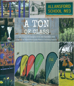
Book, A Ton of Class: 100 favourite recipes from the families and friends of Allansford and District Primary School, 2014
This cookery book was produced in 2014 as a school fundraiser. It was purchased at Allansford Cheese World in January 2015 for $15. Allansford school was established as a National School in 1856 on land reserved for the purpose by John McMahon Allan. It comprised two sandstone classrooms -one for boys and one for girls -with an attached pise teacher's residence. In 1872 when the Victorian Education Department was set up existing schools were listed in alphabetical order and given a number. Allansford State School was No.3. The school was enlarged in the late 1800s and again in the early 1920s. In 1994 following the amalgamation of the Allansford, Allans Forest and Naringal schools a new school was built which adjoined the existing buildings. The old buildings were refurbished as administration and staff facilities. John McMahon Allan settled in the area in 1839 with his brother William Osborne Allan. They were the sons of David Allan, Deputy Commissary General during Macquarie's term of government. The brothers divided the station with William retaining the Allandale portion and John naming his portion Tooram. John McMahon Allan was president of the early district Roads Board. In an attempt to recoup some of the heavy losses due to the disastrous Bateman fire of 1854 John subdivided a portion of Tooram at the Hopkins River crossing known as Allans ford. A school reserve was included in this subdivision. Source: McLeod, Graeme & Barbara. Allansford 1855-2006This book has social and historical interest and significance as it is connected to a local school. It provides a snapshot of food and cooking methods in the early 21st cebturyCookery book with full colour cover featuring 8 photographs and drawings of the Allansford Primary School surrounds and pupil activities on. The images are 'stitched' together with a white zig-zag diamond pattern as if a quilt. The foldout cover has an image of the school's centenary memorial gates and a brief history of the school. Inside the foldout are images of the pupils in each of the school's four team houses. The foldout back cover has full colour images of pupils performing at the school concert. A white strip noting 'our values' is included on the inside back cover foldout. Soft cover, 112 pages.allansford school, a ton of class, allansford primary school, a ton of class recipe book -
 Kiewa Valley Historical Society
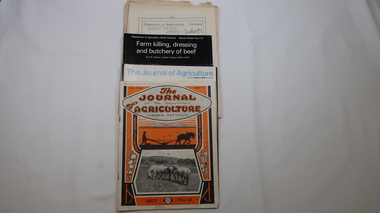
Journals - Department of Agriculture, 1. 1950s and 2. one 1932 & others 1970s
The Kiewa Valley has been a farming district from early settlement of white people. This has continued until the present although the nature of farming has varied over the years. Access to information has improved with transport and technology. The journals kept the farmers informed and up to date.These booklets and journals were one of the few sources of information during the 1950s for the isolated farmers of the Kiewa Valley. The Kiewa Hydro Electric Scheme improved both transport and technology during the scheme's construction from the 1940s. It provided the township of Mt Beauty at the upper end of the valley where shops and schools were constructed, roads were improved out of the valley and the supply of electricity for milking etc. became available. 1. 14 articles each bounded by 2 staples, and each reprinted from Dept. of Agriculture Journal on a particular topic relating to Agriculture. All black & white and c1950s. 2. 4 Journals with colored covers 3 from Victoria Dept. of Agriculture (1932, 1974 & 1975) and 1 from Sth. Australia.1. "J.H.Wallace" hand written top right corner of covers of pamphlets titled 'Diseases Affecting /Young Cattle' and 'Mastitis'. "AHW" hand written top right corner of cover of pamphlet titled ' Grading Land for Irrigation' 2. Nonefarming, agriculture, cattle, pasture, kiewa valley, department of agriculture in victoria, kiewa hydro electric scheme, -
 Kiewa Valley Historical Society
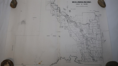
Map - Mullindolingong
Land owners of land in the Kiewa Valley in 1928The Kiewa Valley was farming country with families settling in the area prior to 1928 Two sheets the same: (one old with paper joined together and the other is a copy without any joins. 21 6 1928 dated Map of Mullindolingong / County of Bogong showing land owners along the Kiewa River and beyond.Produced by the Department of Lands and Survey, Melbournemullindolingong, kiewa valley, land owners, families of the kiewa valley -
 Kiewa Valley Historical Society
Papers - Cattle Grazing, Bogong High Plains
Cattle grazing. In the 1990s government departments allocated the number of cattle being taken up to the Bogong High Plains by the families who traditionally leased land there.Cattle grazing had been banned in other Alpine areas due to concerns of their impact on the environment. Kiewa Valley cattle graziers were caught up in the controversy as it was their tradition dating back to the 1840s. This controversy continues as cattle grazing was banned in 2005. 4 pages with black print: 1. 1989/90 Cattle Grazing Allocation and Dept. of Conservation Forests and Lands, Wodonga. 2. Proposed Future Stock Allocations 1991/92 list of 16 families 3. & 4. List of families, ear marks, brands etc. dated 22nd Feb. 1979 stapled togetherex S.C.A. / Benalla / Received 22nd Feb. 1979 / signedcattle grazing, kiewa valley farmers -
 Warrnambool and District Historical Society Inc.
Book (Collection) - Victorian Government Gazettes, Government Printer, Melbourne, Government Gazettes, 1854 to 1895
Warrnambool City CouncilDissemination of Government decisions and actionsWeekly or fortnightly publications bound in volumes according to the yearPrinting of official decisions or actions taken by the Governor of Victoria , Victorian Government authorities, Government Offices, Local Councils , companies and individualsvictorian government gazettes, warrnambool petty sessions, warrnambool customs departmentvictorian government gazettes, warrnambool petty sessions, warrnambool customs department -
 Warrnambool and District Historical Society Inc.
Map, Department of Lands and Survey (Lithographers), Caramut township, 1938
This map of the township of Caramut was produced in 1938 but shows the original land owners of each town allotment and of the surrounding area. The size of all the allotments and the date of the original purchase are also shown. Caramut is a Victorian Western District town on Mustons Creek on the Hamilton Highway 48 kilometres from Warrnambool. This map was used by Rolf Crawley when he was the engineer for the Shire of Warrnambool from 1935 to 1968. The annotations on the map have probably been made by Rolf Crawley as they refer to the records and letter books of his father, John William Crawley, Junior (Shire of Warrnambool Engineer 1895 to 1935). Both Rolf Crawley and his father, John had private businesses as architects, surveyors and engineers and the map could have been used in connection with both their official Shire duties and their private businesses. The last owner of the map was the surveyor, Michael Hand who took over the business of Rolf Crawley in the late 1960s. This map is of great interest firstly because it has all the historical details of the land first purchased in the town of Caramut and area and secondly because it came from the office of Rolf Crawley, the engineer for the Shire of Warrnambool from 1935 to 1968. This is a buff-coloured paper map with a cloth backing. The map details are in black and white print. There are some handwritten red and black annotations on the map. “Town of Caramut Parish of Caramut County of Villiers’town of caramut, john william crawley junior, warrnambool, rolf crawley, warrnambool -
 Eltham District Historical Society Inc
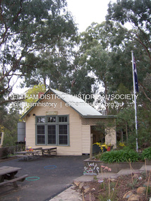
Photograph - Digital Photograph, Marguerite Marshall, Strathewen Primary School, 20 August 2008
The school building originally owned by locals was lost in the Black Saturday 2009 bushfires. Land was purchased in 1914 to build he Strathewen State School on School Ridge Road, Strathewen. Residents and the Education Department contributed funds for the building which the Education Department then leased for a small annual fee. The school opened with one teacher in 1917 with no equipment. In 1921 the Education Department provided desks and a hexagonal shelter shed and took control in 1925. After this photo was taken, the school was destroyed in Black Saturday on 9 February 2009. Published: Nillumbik Now and Then / Marguerite Marshall 2008; photographs Alan King with Marguerite Marshall.; p89This collection of almost 130 photos about places and people within the Shire of Nillumbik, an urban and rural municipality in Melbourne's north, contributes to an understanding of the history of the Shire. Published in 2008 immediately prior to the Black Saturday bushfires of February 7, 2009, it documents sites that were impacted, and in some cases destroyed by the fires. It includes photographs taken especially for the publication, creating a unique time capsule representing the Shire in the early 21st century. It remains the most recent comprehenesive publication devoted to the Shire's history connecting local residents to the past. nillumbik now and then (marshall-king) collection, strathewen primary school -
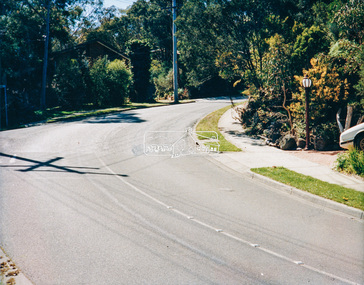
 Eltham District Historical Society Inc
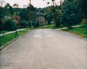
Photograph - Colour Print, Eltham Shire Council, Unidentified road, Eltham district, c.Oct. 1987
Date based on other similar display panels visible in images of the Shire of Eltham display at the Eltham Community Festival, 7 November 1987. 20 x 25 cm Shire of Eltham Engineering Department Providing the resources to undertake • Survey, design, consultation • Road construction and maintenance • Bridge construction and maintenance • Street sweeping • Drain and pit cleaning • Traffic engineering installation and maintenance • Garbage collection • Tip management, land reclamation and beautification • Maintenance of community buildings • Provision of community and recreation facilitiesunidentified, display panel, eltham festival, footpaths and gutters, infrastructure, residential, roads, shire of eltham, streets, 1987 -
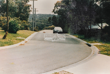
 Eltham District Historical Society Inc
Photograph - Colour Print, Eltham Shire Council, Unidentified road, Eltham district, c.Oct. 1987
Date based on other similar display panels visible in images of the Shire of Eltham display at the Eltham Community Festival, 7 November 1987. 20 x 25 cm Shire of Eltham Engineering Department Providing the resources to undertake • Survey, design, consultation • Road construction and maintenance • Bridge construction and maintenance • Street sweeping • Drain and pit cleaning • Traffic engineering installation and maintenance • Garbage collection • Tip management, land reclamation and beautification • Maintenance of community buildings • Provision of community and recreation facilitiesunidentified, display panel, eltham festival, footpaths and gutters, infrastructure, residential, roads, shire of eltham, streets, 1987 -
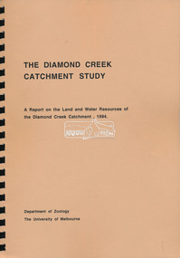 Eltham District Historical Society Inc
Book, Department of Zoology, The University of Melbourne, The Diamond Creek Catchment Study: A report on the Land and Water Resources of the Diamond Creek Catchment, 1994
Shire of Nillumbik -
Glen Eira Historical Society
Document - Caulfield City Rifle Club No. 119, 294 Glen Huntly Road, Elsternwick
Two pages of typed notes on the history of the Caulfield City Rifle Club by Kevin Armstrong, undated. The notes contain a timeline ranging from 1928 to 1969 with emphasis on the cost of ammunition an firearms over time. The file also includes two pages of handwritten research notes, undated and unattributed, about the various changes undergone throughout the early history, 1915 to 1941, of the land and the club.horsey h r, armstrong kevin, elsternwick, elsternwick rifle range, world war 1939-1945, caulfield city rifle club, caulfield city council, glen huntly road, riddell parade, commonwealth defence department, volunteer defence corps, caulfield small bore rifle club, lewis constructions, elsternwick post office -
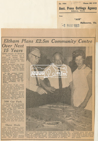 Eltham District Historical Society Inc
Newspaper Clipping, Eltham Plans £2.5m Community Centre Over Next 15 Years, The Age, 6 March 1963 page 7, 1963
Eltham Plans £2.5m Community Centre Over Next 15 Years THE people of Eltham have drawn up a plan to make their township a model community centre in the next 15 years. And yesterday the Chief Secretary (Mr Rylah) inspected the plan at the Eltham shire offices before declaring it open for public inspection In the picture (right) Mr. Rylah (centre) is shown inspecting the new plan with town planner and former councillor, Mr. Howard Bartlett, and the shire president, Cr. C. Pelling. The result of six years' work by shire officers, the plan provides for a business centre, public buildings and recreational reserves. The shire council expects that £2,500,000 will be invested by Government departments, banks, private firms and sporting bodies to implement the plan. 500 Car Park A feature of the business centre will be a quadrangle car park surrounded by shops, and with parking space for 500 cars. The public buildings will include new municipal offices, a public auditorium, a library and meeting rooms. The council plans to realign the course of Diamond Creek near the town to provide extra land for playing fields. Three Ovals The plan proposes three ovals, including improvements to an existing one, as well as a 50-metre Olympic swimming pool, tennis courts and bowling greens. In the 15 years which the shire council hopes to carry out the plan, the shire population of 18,000 is expected to increase two and a half times. Opening the display of maps and a model, Mr. Rylah said he commended the shire council's invitation to the citizens to suggest improvements to the plan. Eltham shire had grown tremendously in the past 20 years, from a sleepy country town to an important shopping centre. Digital file only of copy provided on loanauditorim, bowlong green, charis pelling, eltham community centre, rylah, howard bartlett, car park, library, forward plan -
 Eltham District Historical Society Inc
Photograph, Looking west near 942 Main Road, Hurstbridge, c. Oct 1987, 1987
Yvonne's Dressmaking and Alteration Service at 942 Main Road. Formerly a bakery, the building was demolished in 1990 and is now the site of Hurstbridge Saddlery. The milkbar is down the road, brick wall with a blue sign on it. There's still an older house next to the milkbar, but that's hidden from view in this shot as it's further back from the road. Date based on other similar display panels visible in images of the Shire of Eltham display at the Eltham Community Festival, 7 November 1987. Shire of Eltham Engineering Department Providing the resources to undertake • Survey, design, consultation • Road construction and maintenance • Bridge construction and maintenance • Street sweeping • Drain and pit cleaning • Traffic engineering installation and maintenance • Garbage collection • Tip management, land reclamation and beautification • Maintenance of community buildings • Provision of community and recreation facilitiesPhoto print mounted on carddisplay panel, eltham festival, heidelberg-kinglake road, hurstbridge, hurstbridge milk bar, infrastructure, main road, mm, shire of eltham, yvonne's dressmaking and alteration service -
Federation University Historical Collection
Book - Book - Scrapbook, Ballarat University College: Newspaper Cuttings, January to December 1991 and January to December 1992
Newspaper cuttings collected from various sources. - Ballarat Courier, The Australian, Warrnambool Standard, The Age, The Standard, The News, Ballarat News, East Gippsland News. The items are from 26 January to 20 December 1991 and 11 January to 12 December 1992. Institutions in rush to beat merger date - Victoria's education dilemma. University of the Third Age plan for coming year. Protests over the Government's remarks over Ag Department move. Caution urged by MLC Dick de Fegely. Land rehabilitation program centre at BUC. New university must not be thwarted. $24000 grant provided for specialist lectures. Tertiary education faces crisis as student numbers boom. Lack of student accommodation means some students are living in local hotels. BUC and Melbourne Uni given $500000 grant. It will be used to develop a Masters in Engineering Science (Hydrogeology) course, the first of its kind in Victoria. BUC has opened the F M Krause Broken Hill Mineral collection. Students bring weekend of music to BUC. Nicky Taws and Rob Plowright to represent Australia in the World Orienteering Championships. White A4 two ring folder. Divided into months by coloured dividers. Folder has black marks from previous use.ballarat university college, australia day honor to jack barker, institutions and merger date, university of the third age, protests to government, dick de fegely, buc, land rehabilitation, rmit and merger, student accommodation shortage, masters in engineering science, hydrogeology, krause collection on show, music at buc, nicky taws, rob plowright, orienteering championships, australian women's cricket, development squad camp at buc -
 Federation University Historical Collection
Plan, Department of Crown Lands and Survey, Melbourne, Buninyong County of Grant, 23/07/1929
The plan was photo-lithographed at the Departmen tof Lands and Survey, MelbourneA parish plan of Buninyong, including Robert Scott's Mt Buninyong Pre-emptive Right, Mt Buninyong Public Park, Thomas Learmonth's land, John Learmonth's land, Scotchan's, Yendon. The Buninyong POst Office is Allotment 1. Pisition of tracks in 1859 have been marked on the plan in red.buninyong, scotchman's, mt buninyong, robert scott, clarendon, lal lal creek, yendon, warrenheip, yarowee, enfield, thomas learmonth, john learmonth, archibald fisken, g. schloo, george innes, peter inglis, durham lead, j. fry, j. forrest, parkin lee, buninyong recreation reserve -
 Federation University Historical Collection
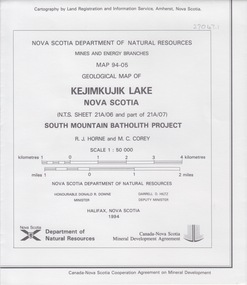
Map - Geological, Nova Scotia Department of Natural Resources, Kejimkujik Lake, Nova Scotia: Geological Map 94-05, 1994
... Produced b Nova Scotia Department of Natural Resources, Mines ...Produced b Nova Scotia Department of Natural Resources, Mines and Energy Branches. The Minister of the Department was the Honourable Donald R Downe and the Deputy Minister was Darrell D HiltzLarge coloured map depicting different areas and deposits. Includes a legend, symbols used, mineral abbreviations and alteration abbreviations.Symbolsnova scotia, kejimkujik lake, geological survey, cartography, mine and energy branches, donald r downe, minister, darrell d hiltz, deputy mnister, south mountain batholith project, legend, symbols -
 Federation University Historical Collection
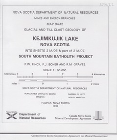
Map - Geological, Kejimkujik Lake, Nova Scotia: Glacial and Till Clast Geology: Map 94-12, 1994
... Department of Natural Resources Land Registration and Information ...Produced b Nova Scotia Department of Natural Resources, Mines and Energy Branches. The Minister of the Department was the Honourable Donald R Downe and the Deputy Minister was Darrell D HiltzLarge coloured map depicting different areas and deposits. Includes a legend, symbols used, mineral abbreviations and alteration abbreviations.Symbols