Showing 214 items
matching murray bridge
-
 Wodonga & District Historical Society Inc
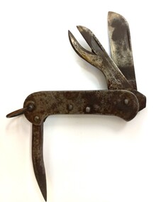
Functional object - Australian Army Issue Clasp Knife
... manufacturing equipment for General Motors Holden. He died at Murray... manufacturing equipment for General Motors Holden. He died at Murray ...Australian manufactured clasp knives were a standard issue to Australian Military Forces during World War 2. The most commonly encountered knife was an all metal model with a canoe shaped body. This knife was a Whittingslowe first pattern clasp knife which included a blade, a tin opener and a marline spike as well as screw driver and shackle to attach the knife to a lanyard or belt clip. These knives were given a dull Nickel plating to protect them. William Thomas Whittingslowe was born in Wales in 1888, he was educated in England and at 18 migrated to Canada and then to Australia, arriving in about 1912. After working in various states, he settled in South Australia and in the 1920s set up his own business, Whittingslowe Engineers Limited. He specialised in ironworking and knife manufacturing. His firm produced a large amount of blade ware during World War 2. He also designed and built manufacturing equipment for General Motors Holden. He died at Murray Bridge (SA) in 1956.This item is significance because it was donated by a member of the community of Wodonga which has a strong connection to Australian military history.A clasp knife made completely from metal with nickel plating. The accessories all fold into a canoe-shaped body. It included a knife, can opener and marlin spike.On knife blade: WE over a broad arrow/I\australian army equipment ww2, thomas whittingslowe, australian army -
 Eltham District Historical Society Inc
Photograph, Tess Justine (Nillumbik Shire Council), Construction work on replacement of Murray's Bridge over the Diamond Creek, Eltham North, 31 Mar 2022
... Construction work on replacement of Murray's Bridge over... melbourne Construction work on replacement of Murray's Bridge over ...Construction work on replacement of Murray's Bridge over the Diamond Creek on the Diamond Creek Trail Mary (Sweeney) Murray and John Wright Murray selected 80 acres, Lot C Section 16 and Lot 5 Section 17 Parish of Nillumbik, under an occupation license in 1866. John died in 1867 and freehold was granted to his son John in 1873. The farm was known as ‘Laurel Hill’. John Junior was an Eltham Shire councillor and sometime president from 1887 up until 1897. He added Lot A Section 16 to the farm in ca1888. John and his younger brother James arranged to rent/purchase Lot B Section 17, across Diamond Creek to the west, in ca1900. It appears that John and James farmed separately for a few years, with a new homestead built for James ad family on the high point of Lot B Section 17 in ca1910. John sold off Lot 5 Section 17 in 1912. When John died in 1912 James took over the land on both sides of the Diamond Creek. The old homestead on the west side of the Creek disappeared. A farm bridge over Diamond Creek from this period may have been located close to the northern boundary of the farm. John Langlands, owner of the farm known as ‘Ihurst’ on the west side of Diamond Creek to the south of the Murray’s land, died in 1907. In 1909 his land was then subdivided into 100 lots to become the ‘Glen Park Estate’. Other similar subdivisions of nineteenth century farms around Eltham in this period included the ‘Franktonia (or Beard’s) Estate’ to the northeast and ‘Bonsack’s Estate’ between Eltham and Greensborough. Soon after the opening of the railway extension line from Eltham to Hurstbridge in 1912, Glen Park and nearby residents including James Murray agitated for a railway station or siding to be located half-way between Eltham and Hurstbridge, so that the Glen Park residents who used the railway daily did not have to walk into the Eltham or Hurstbridge stations. Some believed Coleman’s Corner (opposite Edendale Farm) was an appropriate spot for the platform. James Murray was among those who thought the railway should be located on his land, closer to half-way between Eltham and Hurstbridge stations. The Railways Commissioners warned that the locals would have to fund these works themselves. The Glen Park Estate residents initially had difficulty accessing Eltham by road, with only an old low-level bridge over Diamond Creek at the south end of their estate. A new timber trestle bridge across the creek, now on Wattletree Road, was opened in 1915. Road access to the north was gained in 1927 when the new Murray’s Road, which crossed the Murray’s land, was built. Residents continued to agitate for a Glen Park station. By 1926 the Railways Commissioners’ preferred site was on the Murray’s land. They arranged an estimate of cost of a full-length platform. The estimate was too much for the locals, who in 1928 argued unsuccessfully for a shorter and hence cheaper platform. By 1929 Murray had agreed to donate the land, but the locals would still have to fund the works. Murray decided, unilaterally it would appear, to commence work on a timber trestle road bridge over Diamond Creek to link the new Murray Road to the proposed station. Late in 1929 he stopped work on the bridge, for reasons unknown, but started work again and completed the bridge in 1931. There is no further newspaper evidence of the campaign for the Glen Park station until 1939, when Murray and another local, Mr Maxwell, met the Railways Commissioner. The Glen Park locale now included 45 homes on the west side of the creek and 20 on the Eltham side. Most of the residents used the train every day. The Commissioner remained adamant that only a full-length platform could be built for safety reasons. It appears the campaign dissolved at this point. The increasing move to cars may have had an impact. There is no evidence of Murray’s bridge ever being connected to Murray’s Road, or of it having wide use for any purpose by locals. James Murray died in 1947 and the farm was taken over by his son James (Jim). Jim started to sell off parts of the farm in the 1980s, retaining a few acres around the ca1910 homestead and building a new house there. Recreation reserves were established along the creek. In ca1990 Murray’s bridge was renovated with steel girders as part of a bike/pedestrian path in the reserve. The old farmhouse was demolished in ca2014. Born digital image (5)diamond creek (creek), diamond creek trail, murrays bridge, ‘laurel hill’, john wright murray, mary (sweeney) murra, john murray jnr, james murray, john langlands, ‘ihurst’, ‘glen park estate’, beard's estate, franktonia, bonsack's estate, glen park estate, glen park railway station -
![Scene Near the Buffalo Mountains / [by] Nicholas Caire, circa 1876](/media/collectors/550653872162f11fb04854aa/items/57826074d0cdd1176ce5bcc1/item-media/578260d1d0cdd1176ce5f61a/item-fit-380x285.jpg) Kew Historical Society Inc
Kew Historical Society IncPhotograph, Anglo-Australasian Photographic Company, Scene Near the Buffalo Mountains, c. 1876
... to the River Murray. The Bridge which is seen on the right... district, and eventually finds its way to the River Murray ...Nicholas Caire was born on Guernsey in the Channel Islands in 1837. He arrived in Adelaide with his parents in about 1860. In 1867, following photographic journeys in Gippsland, he opened a studio in Adelaide. From 1870 to 1876 he lived and worked in Talbot in Central Victoria. In 1876 he purchased T. F. Chuck's studios in the Royal Arcade Melbourne. In 1885, following the introduction of dry plate photography, he began a series of landscape series, which were commercially successful. As a photographer, he travelled extensively through Victoria, photographing places few of his contemporaries had previously seen. He died in 1918. Reference: Jack Cato, 'Caire, Nicholas John (1837–1918)', Australian Dictionary of Biography.An original, rare photograph from the series 'Views of Victoria: General Series' by the photographer, Nicholas Caire (1837-1918). The series of 60 photographs that comprise the series was issued c. 1876 and reinforced a neo-Romantic view of the Australian landscape to which a growing nationalist movement would respond. Nicholas Caire was active as a photographer in Australia from 1858 until his death in 1918. His vision of the Australian bush and pioneer life had a counterpart in the works of Henry Lawson and other nationalist poets, authors and painters.‘Scene near the Buffalo Mountains’ : Views of Victoria (General Series) No.41 : Albumen silver photograph | Photo on card with Title and Description on reverse | Mounted 24 x 30 cm; Photo 12 x 17 cm.On Reverse: ‘This scene is taken from the banks of the Buckland River, which is about five miles distant from the Buffalo Mountains, as seen in the distance. These mountains are frequently covered with snow, in consequence of their great altitude. The Buckland River is a small tributary of the Ovens River, which flows through the Beechworth district, and eventually finds its way to the River Murray. The Bridge which is seen on the right of the picture forms the roadway which leads from the Buckland Camp to the Township of Bright.’nicholas caire (1837-1918), landscape photography -
 Puffing Billy Railway
Equipment - Victorian Railways Carriage Foot Warmer
... at Murray Bridge and Stawell on the tip to Melbourne and at Ballarat... took place at Murray Bridge and Stawell on the tip to Melbourne ...During prestige, long distance train journeys some carriages had air-conditioning, and the majority of passengers had to brave unheated carriages. To offer some comfort during the winter months, the non-air-conditioned carriages were provided with footwarmers. These were metal containers roughly 100 mm thick and 300 mm wide, and about 750 mm long, which were filled with salt crystals (concentrated crystalline hydrated sodium acetate). The footwarmers were covered by sleeves of thick canvas, and two footwarmers were usually placed in each compartment of non-air-conditioned carriages. To activate the chemicals, the footwarmers were heated almost to boiling point. This was done by removing the canvas sleeves and placing the footwarmers in a large bath of very hot water. After they had been heated, they were removed from the bath and the sleeves refitted. They were then ready to be placed in the carriages. The McLaren patent foot warmer was used on railways in New South Wales, Queensland, Victoria and South Australia as well as South Africa and New Zealand. It was during the 1901 royal visit by the Duke and Duchess of Cornwall that these foot warmers were first used in New Zealand in the royal carriage. Before railway carriage heating was introduced, McLaren patent foot warmers were placed on the floor of New South Wales government railway carriages from 1891 to provide a little passenger comfort. The rectangular steel container worked a bit like a hot water bottle but instead of water contained six and a half kilograms of loosely-packed salt crystals, (concentrated crystalline hydrated sodium acetate). This was permanently sealed inside the container with a soldered cap. After the foot warmer was heated in vat of boiling water for about one and a quarter hours the crystals became a hot liquid. (The melting point for sodium acetate is 58 degrees). There was a whole infrastructure of special furnaces set up at stations for the daily heating of foot warmers. By 1914 the Victorian railways had 4,000 foot warmers in service and by 1935 there were 33 furnaces at principal stations to heat them. After about 10 hours the container was picked up by the handle and given a good vertical shake which helped the cooled liquid reform into a solid mass of hot crystals. Staff or sometimes passengers shook them en route when the foot warmers began to get cold. However, as they were heavy this was only possible by fit and agile passengers. At the end of the journey the containers were boiled again for reuse on the next trip. Sodium acetate railway foot warmers were introduced in Victoria in 1889, Adelaide to Melbourne express in 1899. "Shaking up" on this service took place at Murray Bridge and Stawell on the tip to Melbourne and at Ballarat and Serviceton on the trip to Adelaide. The use of foot warmers began to decline in New South Wales from the 1930s with the first trial of carriage air-conditioning in 1936, steam heating from 1948 ad LP gas heating from 1961. By the early 1960s the main services using foot warmers were the overnight mail trains. info from : http://www.powerhousemuseum.com/collection/database/?irn=67564#ixzz4UBNzVf6t Under Creative Commons License: Attribution Non-Commercial There was a whole infrastructure set up at stations for the daily heating of foot warmers in special furnaces. In Victoria alone in 1935 there were 33 heating works.Historic - Victorian Railways - Carriage Heater - Foot warmerA rectangular-shaped stainless steel casing with a welded seam down the back and welded ends. There is a handle at one end for carrying and shaking. Inside the foot warmer are two baffle plates and three trays to contain the sodium acetate. There was a cast-iron ball in each internal compartment. puffing billy, victorian railways, carriage haeter, foot warmer, passenger comfort, station furnace, railway ephemera, early heating methods -
 Ballarat Tramway Museum
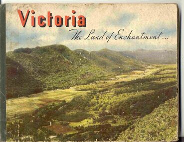
Book, Nu-color-vue or Nucolorvue Productions, "Victoria The Land of Enchantment", c1950
... ), Parliament House, Kiewa Hydro scheme, Eildon Weir, Swan Hill Murray..., Kiewa Hydro scheme, Eildon Weir, Swan Hill Murray River Bridge ...Book with hardcovers, 48 pages titled "Victoria The Land of Enchantment". Sewn in three sections, with a green strip of cloth and self end papers and printed outer paper, sides glued onto board covers. Consists of 43 colour photographs (full and half page) with captions, detailed text, and two black and white photos printed in blue on end covers. Photos of Mt Buffalo, Gippsland lakes, Mornington Beach, Yarra River, Flinders St. station from the Yarra, Collins and Spring St (with two W2's - see image No. 2), Parliament House, Kiewa Hydro scheme, Eildon Weir, Swan Hill Murray River Bridge, Bendigo Post Office, Melbourne Botanical Gardens, Ballarat - Grenville and Sturt St (No. 22 - see image No. 3), Lorne, Yallourn Power Station, Hume Weir, Maroondah Weir, Great Ocean Road, Warrnambool, Portland Beach, A timber train (see image No. 4), Mildura, flax mills, Eastern Geelong and the Prime Ministers Ave, Ballarat. Produced by Nucolorvue Productions, c1950. See also Reg Item 2925 for the same photo of No. 22 and Reg Item 5354 for a postcard. Purchased via eBay site - see attached sheets and packing slip. Purchased 10/2/2005 for A$12.50 including postage, from Virginia Georgopoulos of West Brunswick. eBay sheets and envelope with worksheet file. Has Swains 123 Pitt St, Sydney sticker on bottom left hand corner page 2trams, tramways, ballarat, sturt st, grenville st, bogie trams, geelong, bendigo, melbourne -
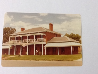
 The Beechworth Burke Museum
Photograph, Unknown c.1930s
This image shows Bethanga Bridge, which was constructed between 1927 and 1930 in Albury, NSW. The bridge was a necessity due to the building of the Hume Dam (Wier), 1919-1936. Bethanga Bridge is a long, nine-span, riveted-steel, variable depth, Pratt Truss road bridge of nine principal spans of 82 metres and a total length of 752 metres over the flooded valley of the Murray River, now part of Hume Reservoir. Because of its unique location, over the waters of a dam with the border running down the centre of the body of water, the Bethanga bridge is the only built structure shared by both New South Wales and Victoria. It was built 1.6 kilometres upstream of the dam and in 1961 was raised 300mm, with a concrete deck replacing the original wooden deck. The State Rivers and Water Supply Commission of Victoria and the New South Wales Department of Public Works were responsible for the construction works for the Hume Weir under the River Murray Waters Agreement. It is apparent that a similar joint arrangement was made for the construction of the Bethanga Bridge as part of the Hume Weir works.This photograph of the Bethanga Bridge is of historical significance as it showcases the architectural skills of Percy Allen and Vincent Packer. Additionally, it reveals the environmental landscape of the 1920s-1930s, is linked to the Hume Dam and both New South Wales and Victorian heritage. Unmounted black and white rectangular photograph. Reverse: 1997.3196 84-20-3bethanga, bethanga bridge, hume dam, pratt truss, murray river, hume weir, transportation -
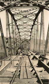 The Beechworth Burke Museum
Photograph, c. 1927 - 1930
Taken during the construction of the Bethanga Bridge (1927-1930), this sepia photograph shows a view of the incomplete bridge taken from inside the structure and looking down the span of the bridge from where the photographer stands. The photograph depicts an incomplete deck, with loose-looking wooden planks/panels lain along the centre in groups of three. Once complete, the original decking of the bridge was made of timber before being replaced by cement in 1961 (Victorian Heritage Database).Bethanga Bridge is of historical significance to the Indigo Shire for its associations with the construction of Hume Dam, its associations with the River Murray Waters Agreement and the River Murray Commission, and illustration of the needs and influence of the farming communities along the river in this area - particularly in relation to the building of the Weir. It also represents the collaboration between New South Wales and Victoria on a large infrastructure project, being the only built structure shared by both New South Wales and Victoria due to its location. also reflecting on the Shire's geographical closeness to this neighboring state. This photograph is part of a series that documents the construction of this well-known heritage site of significance to the Indigo Shire. It reflects upon a period of growth and change in the area.Sepia, rectangular photograph printed on matt photographic paper, unmountedReverse: 1997.3190 / Another snap of the bridge. taken on the bridge showing huge steel sides / 84-19-4 / V [in circle] 354 / KODAK PRINTbethanga bridge, hume dam, bridges album, construction, road construction, hume weir -
 The Beechworth Burke Museum
Photograph, c.1927-1930
This image shows the Punt (a kind of small boat) that took residents of Bethanga across the Murray River before the Bethanga Bridge was built. Bethanga Bridge was built between 1927 and 1930, and was made a necessity by the building of the Hume Dam. The Hume Dam, formerly known as the Hume Weir, was in construction between 1919 and 1936, which swelled the Murray River into the floodplain to the East of the dam permanently, creating Lake Hume, and isolating the residents of Bethanga and nearby towns, for whom the trip all the way around the new lake to another river crossing was a massive undertaking. The person who wrote on the back of this card instead chose to cross the river on a boat until the Bethanga Bridge became available. Interestingly, partially submerged trees can be seen in the lake in the background of this photograph, illustrating that the dam had already begun to fill the floodplain even before the bridge was built. This photograph shows the methods the residents of Bethanga used while the Bethanga Bridge was being built. This record is associated with the Heritage Listed sites of the Hume Dam and the Bethanga Bridge, and shows the environment during the process of construction and the creation of Lake HumeSepia rectangular photograph printed on matte photographic paperReverse: 1997.3189 / 84 -19 -1 / This is the snap of the Punt. / Our only means of getting out / of Bethanga for the present / Until the bridge is completed / it is 2 miles above the junction / of the Mitta + Murray. It is / 1/2 a mile wide + runs across / the Murray into NSW / Kodak Print / bethanga, bethanga bridge, hume, hume dam, artificial lake, lake hume, hume weir, flood, floodplain, boat, punt, weir, pier, dock, transport, transportation -
 The Beechworth Burke Museum
Audio - Oral History, Jennifer Williams, Mr Tom Carey, 3/08/2000
Mr Tom Carey was born in 1940 in Beechworth to family from Beechworth and Woolshed. His family had strong associations with Australia's Gold Rush, with grandparents having followed the rush from town to town, and parents in Beechworth. Tom has strong associations with Beechworth and its surrounds, with his family having some connection to the Kelly Gang. Tom worked in many industries in Beechworth, from the Bridge Road, Price’s Store, tannery, post office, the Kiewa Murray Water Authority, and the Beechworth Council. This oral history recording was part of a project conducted by Jennifer Williams in the year 2000 to capture the everyday life and struggles in Beechworth during the twentieth century. This project involved recording seventy oral histories on cassette tapes of local Beechworth residents which were then published in a book titled: Listen to what they say: voices of twentieth century Beechworth. These cassette tapes were digitised in July 2021 with funds made available by the Friends of the Burke. Mr Tom Carey account of his life in Beechworth and the local area during the 20th century is historically and socially significant to the cultural heritage of the region. He details important historical events and hardships in the region's history that had a lasting local, regional and national impact, including Australia during war time, economic struggles, and women's and men’s societal roles in a rural area. This oral history account is socially and historically significant as it is a part of a broader collection of interviews conducted by Jennifer Williams which were published in the book 'Listen to what they say: voices of twentieth-century Beechworth.' While the township of Beechworth is known for its history as a gold rush town, these accounts provide a unique insight into the day-to-day life of the town's residents during the 20th century, many of which will have now been lost if they had not been preserved. This is a digital copy of a recording that was originally captured on a cassette tape. The cassette tape is black with a horizontal white strip and is currently stored in a clear flat plastic rectangular container. It holds up 40 minutes of recordings on each sideMr Tom Carey/ beechworth, oral history, burke museum, tannery, beechworth council, kelly gang, bridge road, price’s store, post office, the kiewa murray water authority, woolshed, gold rush, carey, tom carey, listen to what they say -
 The Beechworth Burke Museum
Photograph
The photograph depicts two young men standing atop a prominent outcrop at Lake Sambell, with buildings visible on the further shore. The present day park and reserve occupies the site of the former Rocky Mountain Mining Company, an open-cut sluice mine that began operations in the mid-Nineteenth Century and operated until the early 1900s, through the peak of Victoria’s Gold Rush. It was converted into a park and leisure area in the 1920s. Lake Sambell was formally opened to the public on Friday 5th October 1928 and was opened by the Victorian Government’s Minister of Lands, Mr Bailey, as part of initiatives to boost the economies and development of country towns. The lake was named after Mr L.H. Sambell, a shire engineer and secretary of the Forward Beechworth Committee who was involved in promoting the transformation of the mining site and promoting plantation forestry and tourism as alternative industries. £300 to begin the process was provided by Mr J. McConvill, a former resident of Beechworth, who is remembered in a street name adjacent to the lake. An article in the Ovens and Murray Advertiser on Saturday, 5th May, 1917, gives some insight into issues in the Rocky Mountain Mining Company’s final years. The writer details the 1917 annual meeting of the Rocky Mountain Mining Company, stating that locals present appeared ‘well pleased this important local industry is in such a prosperous condition and that future prospects are so encouraging’. The author describes plans to give workers a bonus as evidence of profit-sharing that would ‘bridge the gulf between capital and labour’. The article concludes, however, with the statement that ‘there is a little arithmetical puzzle in the report in connection with the dredging operations I have been unable to solve.' The photograph is significant as it contributes to knowledge about how Beechworth reinvented itself after the Gold rush period, and more broadly how country towns repurpose and redevelop infrastructure and facilities to meet the present needs of their population. Sepia rectangular photograph printed on matte photographic paper. Obverse: nil. Reverse: 3471 / Velox (paper mark)beechworth, beechworth lake, lake sambell, l.h. sambell, mcconvill, rocky mountain mining company, rocky mountain mining co, minister of lands, forward beechworth committee, wallace park-lake sambell development scheme, wallace park lake sambell development scheme, lake, sambell, j. mcconvill, recreation, reserve, park, transformation, repurposed, redeveloped -
 Orbost & District Historical Society
black and white photograph, Murray Studio, Murray Views, 1934
After the flood damage of 1934, the bridge was repaired with a new section in the middle. This bridge remained largely unchanged until its final demolition in 1975 after construction of the new concrete bridge and Orbost by-pass which exists today. This photograph is one of a collection of photographs produced by Murray Views, Gympie. It features eight scenic b/w photographic prints of Orbost and surrounding tourist areas.Photographs like these allowed tourists to send many images of their holiday destination or hometown in the one small package. Fred Murray opened Murray Studios in Gympie in 1906. The postcard and souvenir production side of the business initially covered Gympie and surrounding regions, but Murray expanded the business to include North Queensland, New South Wales and even Adelaide. It was opened under a separate name, Murray Views, in 1929. In 1945 the business was taken over by Murray’s nephews who began postcard folder production. This is a pictorial record of an early bridge across the Snowy River at Orbost.A black / white photograph / postcard of the Snowy River Bridge at Orbost.on front bottom printed - Murray Views No.4 Traffic Bridge , Snowy River, Orbost, Vic.orbost-snowy-river-bridge -
 The Beechworth Burke Museum
Photograph
Taken in Beechworth, this photograph depicts Albert Road looking towards the Ovens and Murray Benevolent Asylum. In the center of the image are figures standing of a bridge. The Ovens Benevolent Asylum (or the Ovens and Murray Hospital for the Aged) was constructed in 1862 on an elevated site overlooking the township of Beechworth. This Asylum was built in response to boom in population due to the discovery of Gold in Beechworth in 1852. This period also saw the development of additional administration buildings such as; the Court house, the Town Hall, and offices. The original Benevolent Asylum building was designed in an unusual Flemish Gothic Revival style. The single storey building is of red brick on a dressed granite base, and the main facade is dominated by four curved, Flemish gable ends, those at the extremities being added to the original central section in 1867. This facade incorporates paired windows of pointed Gothic form and dark brick diaperwork patterning. The adjacent J. A. Wallace Wing of 1899 was designed by Donald Fiddes as a separate building. Also constructed of red brick, Fiddes adopted a conservative approach, designing a simple domestic scale building with central projecting gable porch and flanking bull nosed verandahs. The Benevolent Asylum was renamed the Ovens Benevolent Home in 1935 and The Ovens and Murray Home in 1954. Many buildings have been added to this site, particularly since the 1960s, including a poorly sited addition to the front of the original building. Extensive internal renovations have also been made to the original buildings. [https://vhd.heritagecouncil.vic.gov.au/places/118]Black and white rectangular photograph. The image is printed on matte photographic paper. Obverse: NO INSCRIPTION Reverse: BMM7590 1997.2848 AO2848 beechworth, albert road, benevolent, asylum, burke museum, photograph, black and white -
 Ringwood and District Historical Society
Photograph/Postcard, Postcard - Murray Views No.12. Main Street and Memorial Clock, Ringwood, Vic
Black and white "Murray Views" postcard - Maroondah Highway looking east towards Memorial Clock Tower on Warrandyte Road intersection; railway bridge on right. Circa 1959."1959" handwritten on front. -
 Warrnambool and District Historical Society Inc.
Book, Bridge and how to play it, 1901
This book belonged to the Warrnambool solicitor, Con O’Mahony (1863-1920). In 1883, he won the University of Melbourne Bowen Prize for his essay on the Federation of the Australian colonies. His prize, ten volumes of the ‘Lives of the Chancellors’, is today in the possession of the Warrnambool and District Historical Society. O’Mahony had a legal practice in Warrnambool in the Royal Chambers in Kepler Street at the end of the 19th century and the beginning of the 20th century. He was initially in a partnership with Messrs E.W. Klingender and Murray, then ,when this partnership was dissolved, he continued the business under the name of O’Mahony and later O’Mahony and Murray. He was actively involved in the management of the Warrnambool Mechanics’ Institute and was a member of the Warrnambool Hospital committee. The item here described shows O’Mahony’s interest in bridge-playing, a popular pastime at that time. This book is of some significance as it belonged to Con O’Mahony, a well-known lawyer in Warrnambool in the early 1900s. It also shows the interest in bridge-playing as a pastime during that period. This is a small hard cover book of 112 pages. It was published in 1901(eighth edition) and contains seven chapters on how to play bridge, a scoring table and an index. The last three pages are advertisements for other books on bridge. The cover is yellow with the title of the book, the author’s name and the publisher on the front cover contained within a scroll pattern with four coloured images of the four kings from a pack of cards. The back cover has a list of the British Chess Handbooks published by George Routledge & Sons Ltd. The pages have been annotated (presumably by Con O’Mahony, the Warrnambool solicitor) and some sentences and headings have been underlined.Four stamps – one of ‘May 24 1902’ and three of ‘C.O’Mahony, Solicitor, Warrnambool’.bridge-playing, con o’mahony, warrnambool -
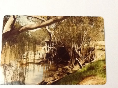
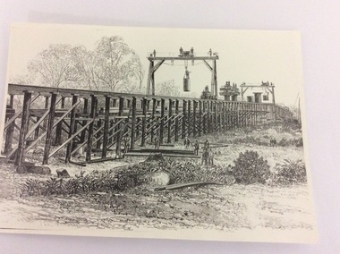 Port of Echuca
Photograph - Black and white photograph of a drawing, A black and white photograph of a drawing of the construction of the bridge crossing the Murray River at Echuca in 1887, 1981
... construction of the bridge crossing the Murray River at Echuca in 1887....A photograph of a drawing of the construction of the bridge... in building a bridge in 1877. The crossing of the Murray River ...The drawing shows all the activity and building roles involved in building a bridge in 1877. The crossing of the Murray River was very important to citizens living in both Echua, but especially those living in Moama and in further NSW regions as it provided them with access to Victorian market regions. The bridge was built privately for Deniliquin farmers, but eventually opened up to the general public.This is significant because it represents the roles of different tradesmen in the construction industry in the late 19th Century. It also shows construction stages . Bridge pylons are being inserted into the fiver banks. It is also a very well produced drawing, the artist is anonymous, but very skilled.A photograph of a drawing of the construction of the bridge crossing the Murray River in 1877. The picture shows surveyors, construction workers, crane operators, hoists and a crane and much activity.Written on the back in pen are the numbers 6530. In pencil are the numbers 61/8"? and 10"?. Stamped on the back is a small rectangle with the words 'COPYRIGHT. This photograph may not be reproduced without permission in writing from the Editot of "The Age" 250 Spencer Street Melbourne, and 39/41 York St., Sydney.' written inside it.bridge works, murray river crossing, moama, echuca, orm cook collection, 'the age' newspaper., deniliquin farmers, engineering, bridge building, pylons, 1877 -
 Port of Echuca
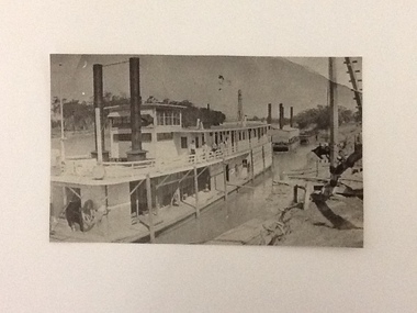
Photograph - Black and white photograph, approx. 1980
P.S. Captain Sturt, with a pile driver in the background. Possibly at Blanchetown. There are 5 men on the upper port deck. The paddle-steamer has 2 funnels and the pile driver has 4 funnels. The wheelhouse is above the upper deck.Demonstrates the use of floating pile drivers to assist in the construction of bridge or wharf building along the river Murray river in approximately the 1920's. The Captain Sturt is in close up so the structure of the paddlesteamer is clear. Rectangular, black and white copy of original photograph of P.S. Captain Sturt, with a pile driver in the background. Possibly at Blanchetown. There are 5 men on the upper port deck. The paddle-steamer has 2 funnels and the pile driver has 4 funnels. The wheelhouse is above the upper deck.In pencil on back: CaptainSturt, Blancheltown or similar. Pile driver in background. On photograph "Captain Sturt" is visible on front and side of the paddlesteamer.blanchetown, p.s.captain sturt, pile driving, murray river, south australia, 1920's -
 Port of Echuca
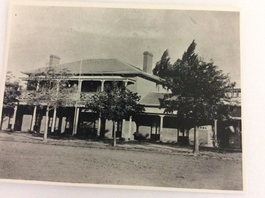
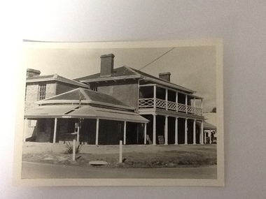
A black and white photograph, The Bridge Hotel, in 1896, showing Silky Oak trees, 1970's
... , which was situated just below the Bridge Hotel on the Murray... was situated just below the Bridge Hotel on the Murray River ...The Bridge Hotel was built by Henry Hopwood to house visitors to the town crossing the Murray River on his punt crossing, which was situated just below the Bridge Hotel on the Murray River. The accommodation was spacious and grand! In the right back corner of the photograph, the 'lantern' roof of the St Georges Hall can be seen. The street is level with the front entrance to the Hotel, which is very different to what it is today.The photograph shows hotel activities and accommodation in the late 19th Century.A black and white photograph of the Bridge Hotel taken from the Hopwood Gardens. The photograph shows four silky oak trees growing along the front of the building. There is an empty flag pole outside the front of the building. The right wing advertises billiards, whilst the left wing apparently was a bar.Written on the building can be seen the words; HOTEL and BILLIARDS. Written in pen on the back of the photograph are the words "Bridge Hotel. Probably 1896, showing Silky Oak trees.bridge hotel, henry hopwood, silky oak trees, lantern roof, st georges hotel -
 Port of Echuca
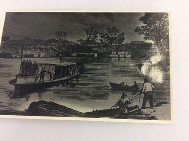
Black and white photograph of an engraving, Approximately 1970
This is a photograph of an engraving showing the first train arriving at the Echuca Wharf on 25/09/1865. The photograph appeared in the Illustrated Australian News on 25/09/1865. It also appeared in Susan Preiestly's book, 'Echuca; A centenary history' in 1965 on page 46.. The picture is of interest because it shows the size of the wharf in 1865. It also shows all the crowds to welcome the first train. It also shows the buildings along Murray Esplanade. In the far left the Steam Packet Hotel, Shackell's Bond Store and the St George's Hall, next the The Bridge Hotel. Five large steam ships are visible, all carrying crowds of people. In the foreground is the S.S Melbourne. Two rowing boats are in the left foreground.This engraving is significant because it shows the welcoming of the first train onto the wharf. The photograph shows the size of the wharf in 1865, as well as the street scape and the vessels on the water at the wharf. There is also some activity at Evan's sawmill. There are crowds on the wharf, and lining Murray Esplanade. It also shows that most of the crowd are males, which helped describe the role that women played in public life in the 1880's. A black and white photograph of an engraving of a busy Echuca wharf scene in 1865. The first train is arriving at the wharf. There are crowds of people, and in the foreground is the S.S. Melbourne. On the front of the photograph in the bottom right hand corner are the letters R.G. (Is this the Artist's initials?) On the back of the photo, written in pencil are the words "Day first train came through to the wharf. Of interest because of buildings far left. Steam Packet 1865. From Ilustrated Australian News. 25th September 1865."echuca wharf, susan preistley, railways, state library of south australia., illustrated australian news., s.s.melbourne, steam packet hotel, shackell's bond store, st george's hall, bridge hotel -
 Port of Echuca
Black and white photograph, 20.04.1979
Relates to a series of 5 photos:P000094-P000098 of the front of the Bridge Hotel on the corner of Murray esplanade and Hopwood gardens. These photos taken in 1976, were before the Port Restoration Scheme renovated the hotel.The Bridge Hotel, Echuca is of historical and social significance in that it was originally built by Henry Hopwood, the founder of Echuca. Hopwood built the hotel to provide accommodation to people using his punts across the Campaspe and Murray rivers. The hotel was situated between the 2 punts. The hotel provided for a variety of levels of accommodation from grand rooms to very basic rooms. At the time of the photos the hotel was 120 years old and became an important part of the Port of Echuca tourism. Black and white photograph of the Bridge Hotel , taken from the corner of Murray esplanade and Hopwood gardens. A power pole pokes through the verandah roof of the eastern (left) wing. The eastern wing of the Bridge is clearly visible.On sign on the front verandah "unauthorised entry not permitted". On back of photo in pen :" 1"bridge hotel, echcua, port restoration scheme, bridge hotel restoration, echuca -
 Port of Echuca
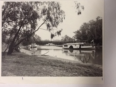
Black and white photograph, Approx. 1980
Information of construction of Pride of the Murray. Construction: Composite Tonnage: 71 gross 36 net Dimensions: L 82.4 ft B 15.5 ft D 4.4 Date of Registration: Melbourne 1870 no.88, 918 Built: Echuca, Vic. 1865 Owners: Permewan, Wights & co.This photo has Social and historical significance,depicting some of the boats and the wharf in the 1980's. It gives a very clear visual of the Port of Echuca wharf and the Echuca banks of the Murray with some of the beach visible. Black and white satin photograph of the starboard side of the P. S. Canberra sailing upstream on Murray river between the Port of Echuca wharf and the Echuca bridge. The Pride of the Murray (front on) can be seen further behind , on the left, with the Pevensey, which appears to be moored in front of the wharf in the background. On front of photo paddlesteamers are marked Canberra & Pride of the Murray. On back of the photo is marked in pencil: please return to Mrs H.Coulson, Port of Echuca, Box 35, Echuca.echuca wharf, p.s. canberra -
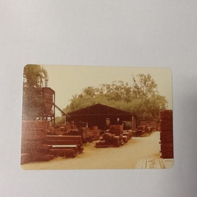
 Port of Echuca
Black and white photograph, Approx. 1975
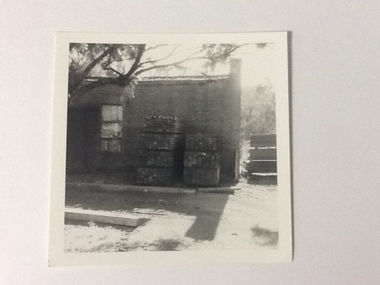
The old brick Murray River Sawmill office was demolished around 1975. This appears to be part of one of the office buildings associated with the sawmill, taken in shadow, with the building well back on the block, on the bridge side. There is a dirt driveway in front of the building and stacks of timber next to the chimney side of the building. Trees are visible behind these stacks of timber. Two stacks of timber (1x 4 blocks high, 1 X 3 blocks high) are in front of the building between the window and the chimney This relates to photographs P000106, P000105 Sawmills in the Echuca area were historically and socially significant being a large employer in the area. The Murray River sawmill was one of the biggest and longest operating sawmills in the area. Black and white photograph of an old Murray River Sawmill building with the chimney to the right and a door and window on the left. Two stacks of timber planks are against the wall between the window and the chimney. A dirt driveway is in front of the building with timber planks edging the driveway.On the reverse in pencil "Old M. R. S. Building well back on the block on the bridge side. Near old offices, also demolished about 1975??" Kodak, , in blue ink "0932"murray river sawmills, echuca, echuca, victoria, pullicino, j (unconfirmed) -
 Port of Echuca
A black and white postcard, 1906. or. 1916
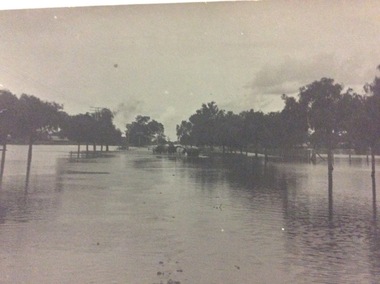
The postcard is significant because it shows the extent of the flood in the early 20th Century. The bridge crosses the Southern Cross channel which had been built as part of the Murray Darling irrigation system. There is a vehicle on the bridge either being towed by bullocks or horses. Floodwaters cover the whole view.The postcard is significant because it shows the extent of the flood in the early 20th Century. The bridge crosses the Southern Cross channel which had been built as part of the Murray Darling irrigation system. It is also near the water filtration plant which filters the town's water supply. There is a vehicle on the bridge either being towed by bullocks or horses. Floodwaters cover the whole view.A black and white postcard showing Goulburn Road, Echuca East, in either the 1906, or 1916 floods.Printed on the back are the words; W. Grimwood Echuca. POST CARD. Correspondence Address Only Kodak Australia. Hand written on the back are the words 1906 or 1916? Southern Cross bridge near filtration plant. Goulburn Road, Echuca East.floods, goulburn road, echuca east, pullicino, j, postcard, southern cross channel, water filtration plant -
 Port of Echuca
Colour Photograph, Approx.1979
... Port of Echuca 74 Murray Esplanade Echuca the-murray ...The Bridge Hotel was built by Henry Hopwood, founder of Echuca. The building was in disrepair until it was bought by the Port of Echuca and renovated to be turned into part of the Port of Echuca tourist exhibits and was leased out to be run as a restaurant.The Bridge Hotel is of historical and social significance to Echuca as it was built be Echuca's founder Henry Hopwood. The hotel was situated between the 2 rivers, Murray and Campaspe, where Hopwood ran his punt business, charging people and animals to cross the rivers. The hotel accommodated a variety of paying guest from wealthy squatters to salesmen and general workers. The building was purchased by the Port of Echuca to be part of the tourist attraction. It was extensively renovated to bring it back to its former glory. The Bridge hotel played an important role in the TV series "All the Rivers Run". Colour photograph of the Bridge Hotel, Echuca, after restorations (c.1979)On front of building : Bridge Hotel / Restaurant Printed on reverse:"This paper manufactured by Kodak"bridge hotel, echuca, port of echuca, echuca, victoria -history, henry hopwood -
 Port of Echuca
Colour photograph, Approx.1979
This photograph shows a punt (with a dingy tied to it ) moored to the wharf structure on the Murray river at Echuca. Punts were used to transport people and goods from one side of the river to the other.Punts were used to cross the Murray river at many spots before bridges were built. Henry Hopwood set up his initial business with punts across the Murray and Campaspe rivers, charging people, animals and vehicles to cross the rivers.Colour photograph of a punt tied to the port structure, seen through the foliage of gums on the river bank.On reverse:" This paper manufactured by Kodak"port of echuca, hopwood's punt, echuca, port of -
 Port of Echuca
Colour photograph, 1979
Discussed in book : Echuca: A centenary history by Susan Priestley, pp.21, 38, 45, 66, 114-123, 126, 174 R.J.Evans established this mill on the banks of the Murray River, Echuca in 1923 & it operated until 1980. The mill later became a tourist attraction, Red Gum Works, continuing to cut timber until it was taken over by The Port of Echuca as a display (Port of Echuca booklet, 2005 ed., p. 32)Sawmilling was a very important industry for Echuca. At its peak in Echuca in about 1877 there were between 1000-1500 men employed in the industry (Priestley, Susan. 1965, p.118). Red gum was sourced from the forests along the Murray river. It is a very strong timber suitable for bridge & wharf building, construction works as well as housing and especially for sleepers for the railways. Mills relied on government contracts especially for the sleepers. Colour photograph (post-card size) of red gum sawmill on the Port of Echcua. Photograph is taken looking north.Printed on reverse: "this paper manufactured by Kodak."echuca, port of echuca, sawmilling, evans, r. j., red gum works -
 Port of Echuca
Photograph - Black and white photograph, Late 1970s
Relates to a series of 5 photos:P000094-P000098 of the front of the Bridge Hotel on the corner of Murray esplanade and Hopwood gardens. These photos, taken about 1976, were before the Port Restoration Scheme renovated the hotel. The Bridge Hotel was built by Henry Hopwood in 1858. This and the Bond Store were Echuca's first 2 brick buildings. Named from Hopwood's nearby pontoon bridge. The building was bought be The Council in 1970. Restored and reopened in 1975.The Bridge Hotel is an important part of Echuca's settlement and development. It was originally built by Henry Hopwood, the European founder of Echuca, in 1859. Hopwood built the hotel to provide accommodation to people using his punts across the Campaspe and Murray rivers that area central to the landscape of the Port. The hotel was situated on the land between both rivers and punts and provided for a variety of levels of accommodation from grand rooms to very basic rooms. At the time of the photos the hotel was 120 years old and became an important part of the Port of Echuca tourism. Black and white photograph of the Bridge Hotel , showing western wing before restoration.Stamped on the reverse "Gazemore Studio, D. G. Gay, 18 Frances Street Echuca 3625.bridge hotel, echcua, port restoration scheme, bridge hotel restoration, echuca -
 Port of Echuca
Photograph, Approx. 1970's
... was situated just below the Bridge Hotel on the Murray River... just below the Bridge Hotel on the Murray River ...The Bridge Hotel was built by Henry Hopwood to house visitors to the town crossing the Murray River on his punt , which was situated just below the Bridge Hotel on the Murray River. The accommodation was spacious and grand! In the right back corner of the photograph, the 'lantern' roof of the St George's Hall can be seen. The street is level with the front entrance to the Hotel, which is very different to what it is today.The photograph shows hotel activities and accommodation in the late 19th Century. The Bridge Hotel was a very busy place as can be seen with women on the balcony, a stage coach full of people, laden carts and buggies.The Bridge Hotel Echuca - photo taken looking south towards front of building. Four people can be seen on the balcony and several gathered under the verandah. In the foreground are several horse-drawn carriages. The road in front of the hotel is unmade and very wide, with the roof of St.George's Hall seen over the right (western) wing of the hotel. Verso: Bridge Hotel, 1860s? St. George's Hall in background.bridge hotel, henry hopwood, lantern roof, st.george's hall, 1870s -
 Port of Echuca
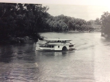
Photograph - Coloured, March 1984
This photograph was taken in February 1984 on the occasion of Cossen's visit to Echuca. P.S Pevensey with the name Philadelphia written across the wheelhouse can be seen steaming upstream under the bridge. This is significant because the P.S Pevensey played the role of the P. S Philadelphia in the movie "All The Rivers Run" which was filmed in Echuca in late 1982 and a sequel was filmed in Echuca early in 1989. Councillor Bob Snow can also be seen on the side deck. This is significant as the Cossen's visit to Echuca may have warranted this sort of attention The photograph also shows the state of the Echuca Moama bridge in the early 1980's.This photograph is significant because it shows the P.S. Pevensey showing the name P.S Philadelphia. The P.S Pevensey was used as the P.S Philadelphia in the TV Series "All The Rivers Run" based on the novel written by Nancy Cato. The TV series was filmed in Echuca in 1982. The TV series was a huge success and still draws tourists to the Port of Echuca. The fact that the P.S Pevensey was showing the Philadelphia name in 1984 is a bit of a mystery, but it has been known that she was dressed up again as the P.S Philadelphia sometimes for special occasions. The Cossen's visit to Echuca might have been such an occasion. It is also a good picture of the pylons under the Echuca Moama bridge and the actual bridge itself. The P.S Pevensey travelling upstream under the Echuca Moama bridge. There is a group of people on the lower side deck. People can also be seen in the wheelhouse and there is a man standing on the back deck as well as one standing next to the wheelhouse. The name Philadelphia can be seen written across the front of the wheelhouse. The river is low and shows the waterline at the Moama Beach. Four bridge pylons can be seen as well as the bridge itself.greenspot photography, p.s pevensey, murray river, echuca, la grue, bill, cossen's visit to echuca., all the rivers run, p. s philadelphia, echuca moama bridge, cossen family, cato, nancy -
 Port of Echuca
A coloured rectangular photograph
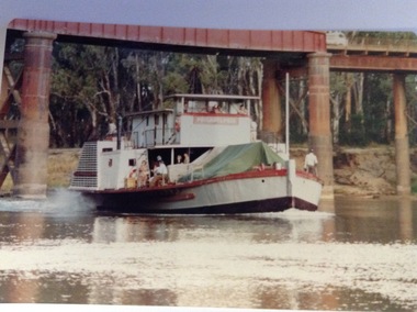
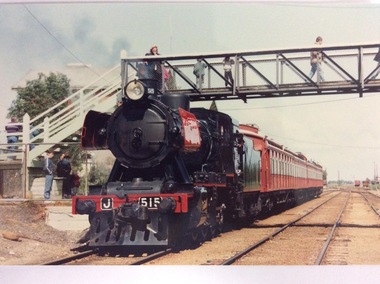
This photograph which could have been taken in the 1970's. It shows the state of the station and it's surrounds at that time. It also shows the good condition of the J Locomotive at that time.This photograph shows that state of the J class locomotive at that time. It appears to be in very good condition. The passenger carriages behind appear to be more of the usual carriages used in the 1970's.The J Class locomotive and train passing under the Echuca Station footbridge. Some people are on the bridge and also next to the train.Verso: Hart's 01301111NNNN037railways, echuca station, j locomotive -
 Port of Echuca
Black and white photograph, Mid 20th Century
The P.S Canberra was built in 1912 at Goolwa South Australia by David Milne. It was built as a fishing vessel. It was originally a steam engine, reverted to diesel, but was returned to steam in 1995. It is currently owned by the Murray Steam Ship and Tourist Co. and has operated as a tourist vessel at Echuca Since 1967. (Ref Parsons, R "Ships of the Inland Rivers " p. 58)The P.S Canberra is significant as it has operated as a tourist vessel since 1967, and continues to do so. A black and white photograph of the P.S.Canberra coming downstream from the iron bridge at Echuca.On boat the words Canberra.p.s canberra, murray steam ship & tourist company